
Diagnosis runoff concept Julie Maillet-Mezeray, Benoît Réal Arvalis-Institut du Végétal, France...
19
Diagnosis runoff concept Julie Maillet-Mezeray, Benoît Réal Arvalis-Institut du Végétal, France EU Stakeholder Workshop, 26th April 2012, Brussels
-
Upload
holly-elliott -
Category
Documents
-
view
219 -
download
0
Transcript of Diagnosis runoff concept Julie Maillet-Mezeray, Benoît Réal Arvalis-Institut du Végétal, France...

Diagnosis runoff concept
Julie Maillet-Mezeray, Benoît Réal Arvalis-Institut du Végétal, France
EU Stakeholder Workshop, 26th April 2012, Brussels

Flow theme
Different water pathwaysDatas needed to assess water pathways
Existing audit methodology
Decision support tools to help decision making

Linking water pathway and mitigation measures
Soil surface
Permeability
disruption
Leaching
Surface Run off
Lateral seepage or
drainage
Different water flow pathsPossible ways of transfer for potential pollutantsBMP options adapted to type of water flow path
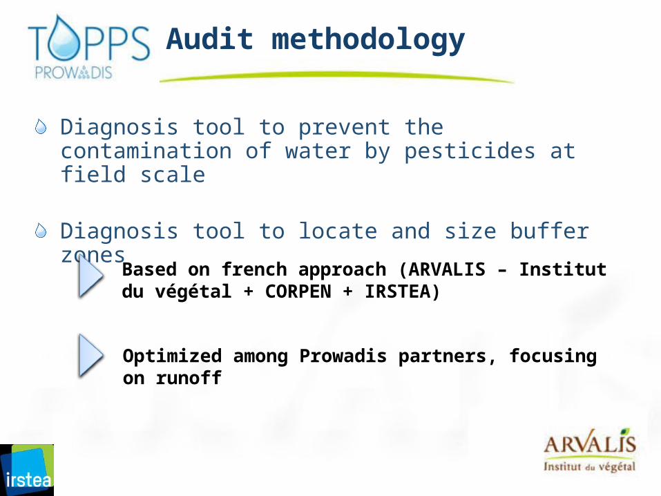
Audit methodology
Diagnosis tool to prevent the contamination of water by pesticides at field scale
Diagnosis tool to locate and size buffer zones
Based on french approach (ARVALIS – Institut du végétal + CORPEN + IRSTEA)
Optimized among Prowadis partners, focusing on runoff

Audit methodology at plot scale
During both spring and winter time
Based on CORPEN methodology
1
Method
Assess effect of practices
Identification of water circulation and exposed water
-
Data collection
Risk assessment
sol argileux
sauf sol argileux
Propose adapted solutions1. Soil management2. Cropping practices3. Adapting PPP and timing4. Vegetative buffer5. Wetlands
Landscape, farm description, types of soil, geology… with the farmer Hydrology categorisation at the
plot scale
Linking water circulation at plot scale within the
catchment
2
3
4
5
Tillage practices, application periods and PPP Used
Developed by ARVALIS-Institut du végétal : : AQUAPLAINE®
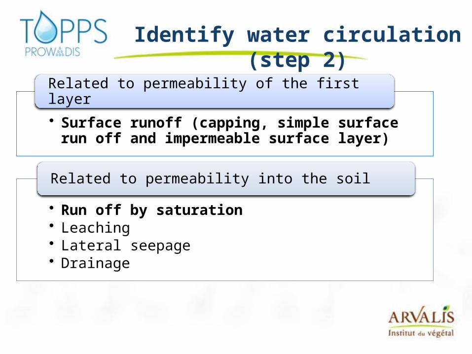
Identify water circulation (step 2)
• Surface runoff (capping, simple surface run off and impermeable surface layer)
Related to permeability of the first layer
• Run off by saturation• Leaching• Lateral seepage• Drainage
Related to permeability into the soil
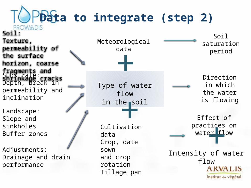
Soil:Texture, permeability of the surface horizon, coarse fragments and shrinkage cracksSubstrate:Depth, break in permeability and inclination
Landscape:Slope and sinkholesBuffer zones
Adjustments:Drainage and drain performance
Meteorological data
Cultivation dataCrop, date sown and crop rotationTillage pan
Type of water flowin the soil
Direction in which the water is flowing
Effect of practices on water flow
++
Soil saturation
period
+Intensity of water flow
Data to integrate (step 2)
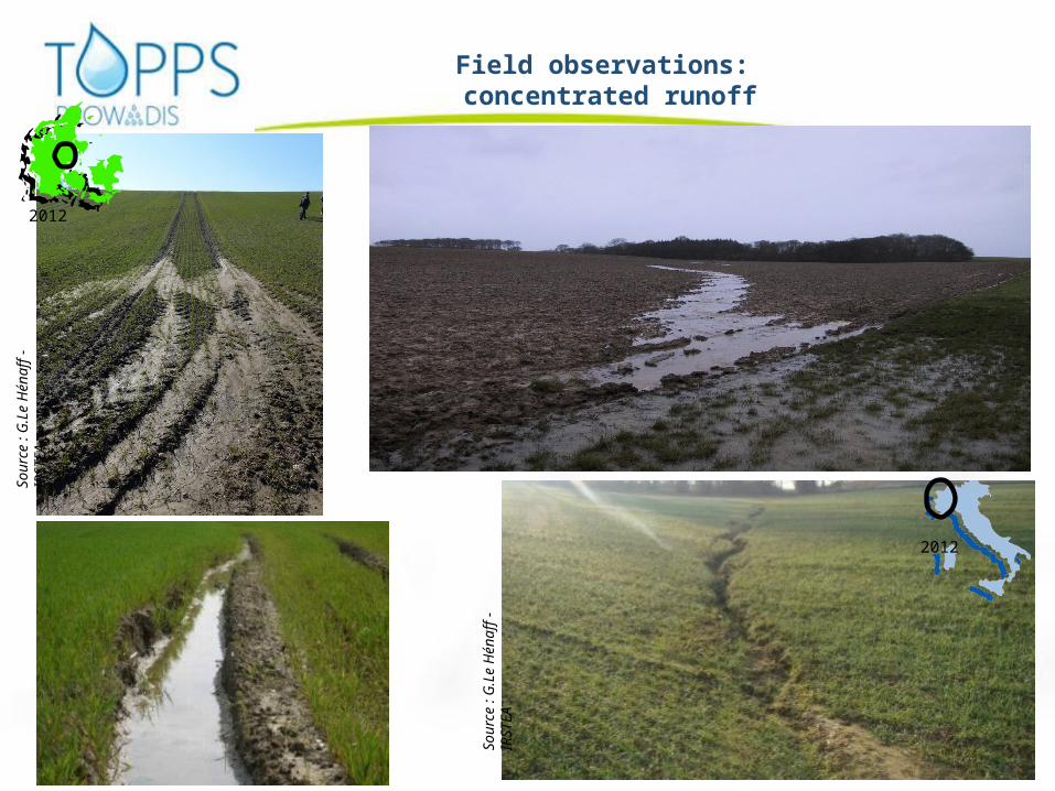
Field observations: concentrated runoff
Sour
ce :
G.L
e H
énaff
- IR
STEA
2012
2012
Sour
ce :
G.L
e H
énaff
- IR
STEA
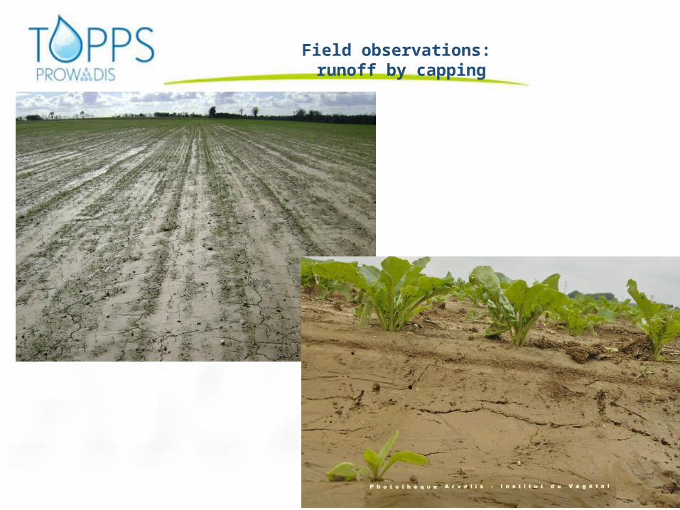
Field observations: runoff by capping
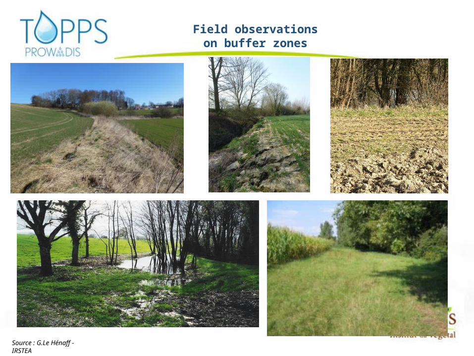
Field observationson buffer zones
Source : G.Le Hénaff - IRSTEA
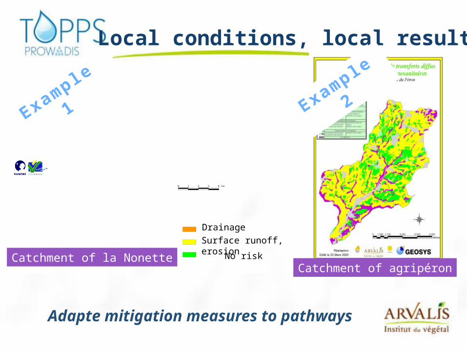
Local conditions, local results
0 2 4 6 8 Km
No risk
DrainageSurface runoff, erosion
Catchment of la NonetteCatchment of agripéron
Adapte mitigation measures to pathways
Example 1
Example 2
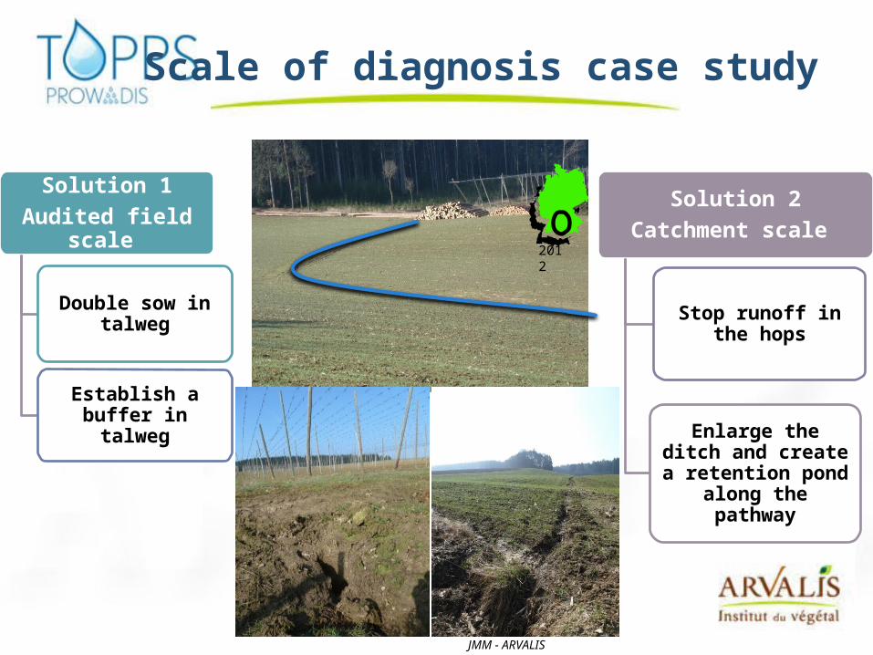
Solution 1Audited field scale
Double sow in talweg
Establish a buffer in talweg
Solution 2Catchment scale
Stop runoff in the hops
Enlarge the ditch and create a retention pond
along the pathway
Scale of diagnosis case study
2012
JMM - ARVALIS
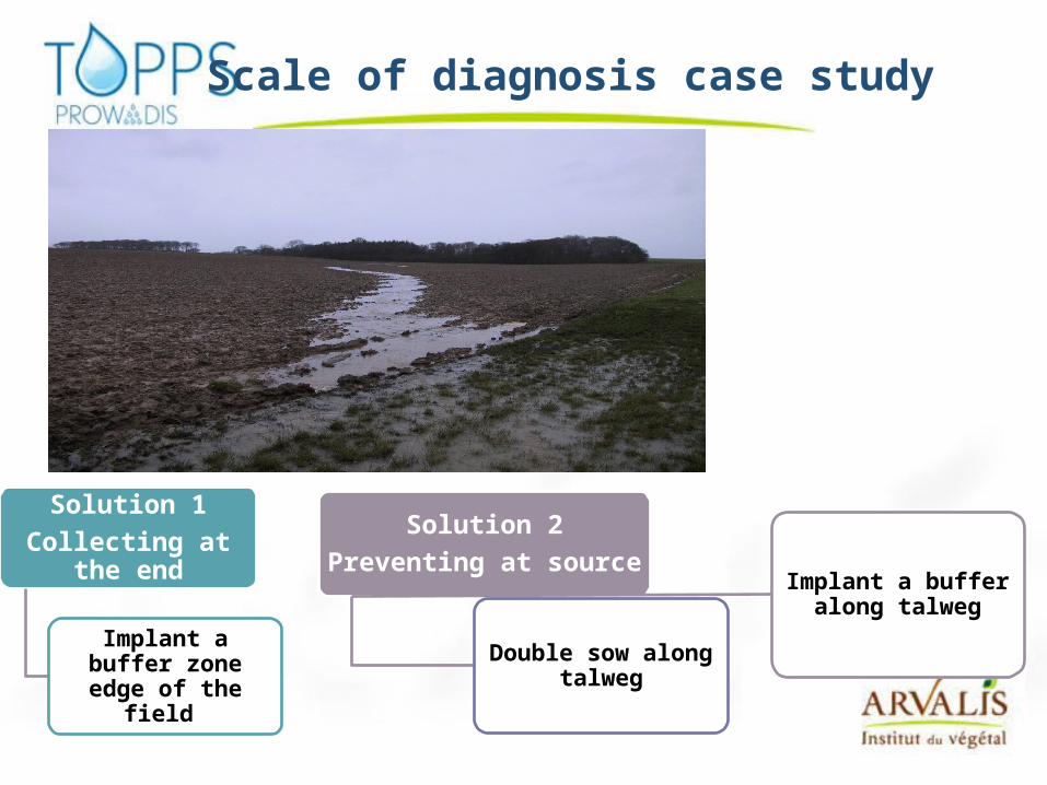
Solution 1Collecting at the end
Implant a buffer zone edge of the field
Solution 2Preventing at source
Double sow along talweg
Implant a buffer along talweg
Scale of diagnosis case study

Support risk assessment
Catchment + field diagnosis observations
DETERMINE RISK SITUATION
1. Assessment of runoff risk regarding soil caracteristic and landscape
• Restrictions of Infiltration• Saturation excess• Specific for concentrated run off
2. Assessment of runoff risk including practices
3 Assessment of efficiency of buffer zones
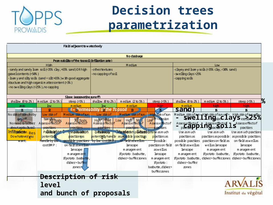
Decision trees parametrization
Rest
Description of the characteristic of the soil- clayey and loamy soils (>35% clay, <30% sand)- swelling clays >25%- capping soils
Description of risk level and bunch of proposals
medium (2 to 5%) steep (>5%) medium (2 to 5%) steep (>5%) medium (2 to 5%) steep (>5%)low medium medium high high highI2 I3 I3 I5 I6 I6
Low risk of transfer.
Assess effect of practicesProbably
potentially handle by low
cost BMP :
Medium risk of run off
Assess effect of practices
Use as much practices as
possible: practices on field as well as
lanscape management
if potato : barbutte, dicker + buffer
zones
Medium risk of run off
Assess effect of practices
Use as much practices as possible: practices
on field as well as lanscape
managementif potato : barbutte,
dicker + buffer zones
High risk of run off + erosion
Assess effect of practices
Use as much practices as
possible: practices on field
as well as lanscape
managementif potato :
barbutte, dicker + buffer zones
High risk of run off + erosion
Assess effect of practices
Use as much practices as possible: practices on field as
well as lanscape management
if potato : barbutte, dicker + buffer zones
High risk of run off + erosion
Assess effect of practices
Use as much practices as possible: practices
on field as well as lanscape
managementif potato : barbutte,
dicker + buffer zones
Low
Field adjacent to water body
Medium- clayey and loamy soils (>35% clay, <30% sand)- swelling clays >25%- capping soils
- other textures- no capping of soil
I1
Permeability of the topsoil (infilration rate)High
shallow (0 to 2%)Slope (aggravating runoff)
No risk of transfer by run off.
No need to bother about agricultural
practice.Do whatever you
want.
Low risk of transfer.
Assess effect of practicesProbably
potentially handle by low cost BMP :
I2low
Medium risk of run off
Assess effect of practices
Use as much practices as
possible: practices on field as well as
lanscape management
if potato : barbutte, dicker + buffer
zones
shallow (0 to 2%) shallow (0 to 2%)zero
No drainage
- sandy and sandy loam soil (<35% clay, >65% sand) OR high gravel contents (>50%)- loamy and silty soils (sand + silt >65%) with good aggregate structure and high organic matter content (>3%)- no swelling clays (<25%), no capping
mediumI4
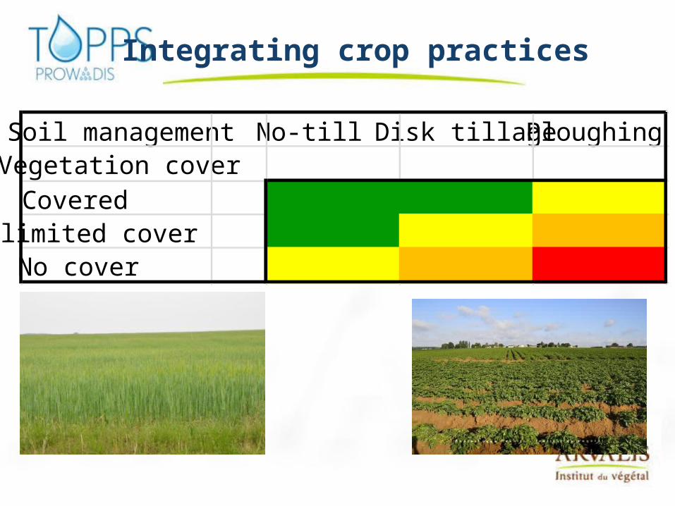
Integrating crop practices
Soil management No-till Disk tillage PloughingVegetation coverCoveredlimited coverNo cover

Concentrated runoff
Yes generated in the audited field
No Yes
Coming from uphill (generated on a field up in
catchment)
Concentrated
Slightly Clearly concentratedConcentrated in
Wheel tracksConcentrated in
cornerConcentrated in
access areaStraight to slope (through talweg)
Straight to slope (trough talweg)
Need to prevent concentrated run
off up in catchment
Make audit of the field where
run off generated
Need to prevent generation of
concentrated run off in wheel tracks
Need to prevent generation of
concentrated run off coming in corner,
specially if in direct contact with waterNeed to collect it
specially if in direct contact with water
Check outlet of concentrated run
off .If going down on
road can contaminate water
further down
Double sowing ? straight to slope
Gully can be observedPrevent at sources
Intercept on its way down
Measure related to Landscape
management to be applied
Buffer may be useful to
intercept run off.
See measure : Manage wheel tracks,Run across the slope
if possible, Practice double
sowing in some area, Enlarge headland
Buffer zones in corner if corner is not
hydromorphic
See measure : Manage field access area
Buffer straight to slope buffer

Different scales for the diagnosis
Catchment
Area Region: Decision making unit for stakeholders
Catchment: Investigation unit to understand transfer and implement suitable action plan
Fields: Units to understand the movement of excess water: In different locations in the catchmentAt different period of time
Farm: Decision making unit

Conclusion
Field audit needed
Methodology available
Help tool to support audit: decision trees in progress
Practical, acceptable, implementable


![Locomotives - data.bnf.frLocomotives. - Humphrey Jennings, réal.. - [2] (2011) Passion en DVD (2008) Zones d'ombre (2004) Documents électroniques (3) Les Trans Europ](https://static.fdocuments.us/doc/165x107/606bca6e0bcad91486797fe4/locomotives-databnffr-locomotives-humphrey-jennings-ral-2-2011.jpg)

![DataDreadlock holiday. - Storm Thorgerson, réal.. - [7] (1988) avec 10cc comme Groupe vocal et instrumental The wall street shuffle. - Phill Bishop, réal.. - [4] (1988) avec 10cc](https://static.fdocuments.us/doc/165x107/5ffd73535645bf48b700d477/data-dreadlock-holiday-storm-thorgerson-ral-7-1988-avec-10cc-comme.jpg)

