
Developments of EUREF's GNSS Reference Network (EPN) · 3. Austria BEV - Bundesamt für Eich- und...
26
Developments of EUREF’ s Developments of EUREF s GNSS Reference Network GNSS Reference Network EPN Johannes Ihde 1) (BKG), Carine Bruyninx (ROB), Heinz Habrich (BKG), Ambrus Kenyeres (FÖMI), Markku Poutanen (FGI) 1) Contact: Federal Agency for Cartography and Geodesy (BKG) Richard-Strauss-Allee 11 D-60598 Frankfurt on Main [email protected] International Symposium on Global Navigation Satellite Systems, Space-based and Ground-based Augmentation Systems and Applications B li G 11 14 N b 2008 EUREF’s EPN EUPOS Symposium 2008 1 Berlin, Germany, 11 - 14 November 2008
Transcript of Developments of EUREF's GNSS Reference Network (EPN) · 3. Austria BEV - Bundesamt für Eich- und...

Developments of EUREF’sDevelopments of EUREF s GNSS Reference NetworkGNSS Reference Network
EPNJohannes Ihde 1)(BKG), Carine Bruyninx (ROB), Heinz Habrich (BKG),
Ambrus Kenyeres (FÖMI), Markku Poutanen (FGI)
1)Contact: Federal Agency for Cartography and Geodesy (BKG)
Richard-Strauss-Allee 11D-60598 Frankfurt on Main
International Symposium on Global Navigation Satellite Systems, Space-based and Ground-based Augmentation Systems and Applications
B li G 11 14 N b 2008
EUREF’s EPN EUPOS Symposium 2008 1
Berlin, Germany, 11 - 14 November 2008

EUREF• Creation in 1987 at the IUGG General
A bl i VAssembly in Vancouver• Sub-commission 1.3a of IAG • Central Bureau of EPN in Brussels, Secretary
in Munich• Permanent committee is the Technical
Working Group with about 15 members (3 i )meetings per year)
• Links to about 130 European organizations, p gagencies, universities – related to geo-referencing, positioning, and navigation
EUREF’s EPN EUPOS Symposium 2008 2

Outline
(1) Mission of EUREF(2) Definition and Realization of
European Geodetic Reference SystemsEuropean Geodetic Reference Systems, EUREF’s Network Infrastructure
(3) From Reprocessing and Velocity Fields t R l Ti N t k M it ito Real-Time Network Monitoring
(4) Summary(4) Summary
EUREF’s EPN EUPOS Symposium 2008 3

(1) Mission of EUREFDD fi iti li ti d i t fDDefinition, realization and maintenance of the European Geodetic Reference Systems
• Promotion and assistance of the adoption and use of European Terrestrial Reference System (ETRS89) in E i li t t ITRFEurope in alignment to ITRFxx
• The EUREF GNSS Permanent Network (EPN) is the d b d GNSS i f t t f i tifi dground based GNSS infrastructure for scientific and
practical applications in positioning and navigation (GGOS, IGS-RT)
• The definition and realization of the European Vertical Reference System has arrived 2007 a new stage (EVRS2007)
• Provides all its products on the “best effort” basis and
EUREF’s EPN EUPOS Symposium 2008 4
Provides all its products on the best effort basis and free of charge to the public

Network of Cooperation
Memorandum of Understanding
M d fMemorandum of Understanding
WEGENERICG
EUREF’s EPN EUPOS Symposium 2008 5

1. Albania Institut Studimit Tokave 35. Slovakia Úrad geodézie, kartografie a katastra SR
NMCA’s2. Armenia State Committee of the Real Property Cadastre3. Austria BEV - Bundesamt für Eich- und Vermessungswesen4. Belarus State Committee for Land Resources, Geodesy and Cartography5. Belgium - Nationaal Geografisch Instituut / Institut Géographique National
- Administration du Cadastre, de L'Enregistrement et des Domaines / Administratie van het Kadaster, de Registratie en de Domeinen
6 Bosnia & Herzegovina
g , g36. Slovenia Geodetska uprava republike Slovenije37. Spain - Instituto Geográfico Nacional
- Dirección General del Catastro38. Sweden Lantmäteriet39. Switzerland Bundesamt für Landestopografie40. The Netherlands Kadaster en Openbare Registers6. Bosnia & Herzegovina
Federal Administration for Geodetic and Real Property Affairs 7. Bulgaria Ministry of Regional Development and Public Works8. Croatia Drzavna Geodetska Uprava 9. Cyprus Department of Lands and Surveys, Ministry of the Interior10. Czech Republic Cesky urad zememericky a katastralni11. Denmark Kort og Matrikelstyrelsen
41. Turkey Harita genel komutanligi, General Command of Mapping
42. Ukraine State Service of Geodesy, Cartography and Cadastre
12. Estonia Maa-amet13. Finland - Maanmittauslaitos
- Finnish Geodetic Institute 14. France IGN – Institut Géographique National 15. Germany BKG - Bundesamt für Kartographie und Geodäsie16. Great Britain Ordnance Survey of Great Britain17 Greece Hellenic Military Geographical Service
More than 50 members from more than 40 t t17. Greece - Hellenic Military Geographical Service
- Hellenic Mapping and Cadastral Organisation18. Hungary Földügyi és Térképészeti Foosztály19. Iceland - Landmælingar Íslands
- Fasteignamat Rikisins20. Ireland Ordnance Survey of Ireland21. Italy Instituto Geografico Militare Italiano
40 states
22. Kosovo Kosovo Cadastral Agency23. Latvia - LR Valsts zemes dienests
- Latvijas Geotelpiskas Informacijas Agentura24. Lithuania - National Land Service
- State Enterprise, Centre of Registers25. Luxembourg Administration du Cadastre et de la Topographie26. Malta Malta Environment and Planning Authorityg y27. Moldova National Agency of Cadastre, Land Resources and Geodesy28. Northern Ireland Ordnance Survey of Northern Ireland29. Norway Statens kartverk30. Poland Glówny Urzad Geodezji i Kartografii31. Portugal Instituto Geografico Português32. Romania Agentia Nationala de Cadastru si Publicitate Imobiliara
EUREF’s EPN EUPOS Symposium 2008 6
33. Russia Federal Service of Geodesy and Cartography of Russia34. Serbia & Montenegro
Republicki Geodetski Zavod

(2) Definition and Realization of E G d ti R f S t
ETRS89 (European Terrestrial Reference System 89)European Geodetic Reference Systems
• The datum is fixed to the stable part of the European Plate at the epoch 1989 0 (ITRF89)Plate at the epoch 1989.0 (ITRF89)
• Realized by ETRFxx derived from ITRFxx by removing the mean velocity of the European plate (xx is currently 2005)
• based on EUREF GNSS Permanent Network EPN• European Commission adopted ETRS89 as the geodetic
datum for geo-referenced information of the ECdatum for geo referenced information of the EC
EVRS (European Vertical Reference System 2007)( p y )
• Related European Vertical Datum (NAP)• Realized by the United European Levelling Network (UELN)
EUREF’s EPN EUPOS Symposium 2008 7
• Realized by the United European Levelling Network (UELN)• The use of EVRS 2007 vertical datum by EC is planned.

EUREF GNSS Permanent Network - EPN
8 Science-driven GNSS network serving high precision users in Geodesy, Geophysics, Timing, Navigation
8 Densification of the IGS (International GNSS Service) in EuropeDensification of the IGS (International GNSS Service) in Europe
8 European contribution to global geodetic networks8 Operating under the IGS standardsOperating under the IGS standards
– GPS & GPS+GLONASS tracking stationsData Centres providing free access to the observation data (daily– Data Centres providing free access to the observation data (daily & hourly RINEX)
– Analysis Centres computing station coordinates and by-products
Brest, FranceMatera, Italy
Sajarevo, Bosnia/Hercegovina
Vaasa, Finland
EUREF’s EPN EUPOS Symposium 2008 8

EPN is the Densification of ITRF2005 and the Realization of ETRS89
8 212 permanent GNSS stations
GNSS Station (212)Data centre (7)Analysis centre (16)
(80 GPS/ GLONASS)
Analysis centre (16)3 of them provide combined GPS/GLONASS products
8 87 of them are IGS stations
products
8 38 European countries arecountries are covered
8 About 100 contributing agencies
EUREF’s EPN EUPOS Symposium 2008 9
g

http://www.epncb.oma.be/
EUREF’s EPN EUPOS Symposium 2008 10

EVRF2007 –Summary of the adjustment parameters
• Datum realization by 13 datum points• Reduction to the zero tidal system
y j p
Reduction to the zero tidal system• Reduction of the measurements to the epoch 2000
using the whole NKG2005LU model
Parameter EVRF2000 EVRF2007 Number of datum points 1 13 Number of unknowns 3063 7939Number of measurements 4263 10347 Number of condition equations 0 1 equations Degrees of freedom 1200 2409 A-posteriori standard deviation referred to 1 km levelling distance in 1.10 1.11levelling distance in kgal·mm Mean value of the standard deviation of the adjusted geopotential numbers 19.64 16.05
EUREF’s EPN EUPOS Symposium 2008 11 11
geopotential numbers ( =̂ heights), in kgal·mm Average redundancy 0.281 0.233

UELN lines andUELN lines and datum points of
EVRF2007EVRF2007
EUREF’s EPN EUPOS Symposium 2008 12 12

EUVN Densification Action (EUVN_DA) 1200 GNSS/levelling points
• for European geoid determination EGG07
• for the validation of the satellite gravity field
i i
CHAMP GRACE
missions
EUREF’s EPN EUPOS Symposium 2008 13
GOCE

European Combined Geodetic Network – ECGNA Regional GGOS Component
• 21 countries• 74 stationsWith
g p
With
GNSS (EPN)absolut gravitylevelling to EVRS6 super
d ticoducting grav.15 tide gauges
8 ECGN core8 ECGN core42 ECGN7 candidate15 proposedp p
EUREF’s EPN EUPOS Symposium 2008 14

ECGN A Regional Densification of GGOS
• ECGN integrates fundamental geodetic techniques for the l t b ti f E th t t
A Regional Densification of GGOS
long-term observation of Earth system parameters. • ECGN plan follows the guidelines of the IAG Project GGOS
Areas to Study• Glacial dynamics, postglacial rebound• Crustal stability• Global climate change and its consequences
ParametersParametersHeight / height systemsSea LevelSea LevelGeodetic position, reference framesGeopotential and gravity anomalies
EUREF’s EPN EUPOS Symposium 2008 15
Temporal gravity change

Nordic Geodetic Observing System - NGOS A Regional Densification of GGOS and ECGNg
• Absolute gravity points• Absolute gravity points (triangles) measured with FG5 absolute gravimeters
• Tide gauges (circles)• Tide gauges (circles). • Nordic permanent GPS network (upside down i l ) ll b ltriangles) at all absolute
gravity points and tide gauges
Key item: Determination of yrelation between uplift and gravity change.
EUREF’s EPN EUPOS Symposium 2008 16

Outline
(1) Mission of EUREF(2) Definition and Realization of
European Geodetic Reference SystemsEuropean Geodetic Reference Systems, EUREF’s Network Infrastructure
(3) From Re-processing and Velocity Fi ld t R l Ti N t kFields to Real-Time Network Monitoring – Projects, Examples, Ideasg j p
(4) Summary
EUREF’s EPN EUPOS Symposium 2008 17
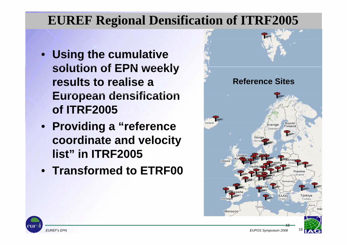
EUREF Regional Densification of ITRF2005
• Using the cumulative solution of EPN weeklysolution of EPN weekly results to realise aEuropean densification
Reference Sites
European densification of ITRF2005P idi “ f• Providing a “reference coordinate and velocity li t” i ITRF2005list” in ITRF2005
• Transformed to ETRF00
EUREF’s EPN EUPOS Symposium 2008 1818

European velocity field
EPN c m lati ecumulative solution
May serve as reference for the densification of the European regionalEuropean regional velocity field
(IAG WG on “Regional Dense Velocity Fields”, headed by C.Bruyninx)
2D velocities wrt the EURA plate,d i d f b ti 1996 2008
EUREF’s EPN EUPOS Symposium 2008 19
headed by C.Bruyninx)derived from observations 1996-2008

EPN Re-processingStatus:Inhomogeneous 'historical' observation series(standards models reference frames )(standards, models, reference frames ... )
Objective:• Densification of ITRFxx• Realization of ETRS89• European 3D-velocity field• European 3D-velocity field
Actions:• Pilot re-processing done in 2007/08 by MUT* and ROB• Project on the basis of PDR05 is in work (TU Dresden, BKG)• “Official” EUREF re-processing will follows the IGS scheduleOfficial EUREF re processing will follows the IGS schedule
and standards (2009-2010)• Continuously re-processing for EPN monitoring
EUREF’s EPN EUPOS Symposium 2008 20
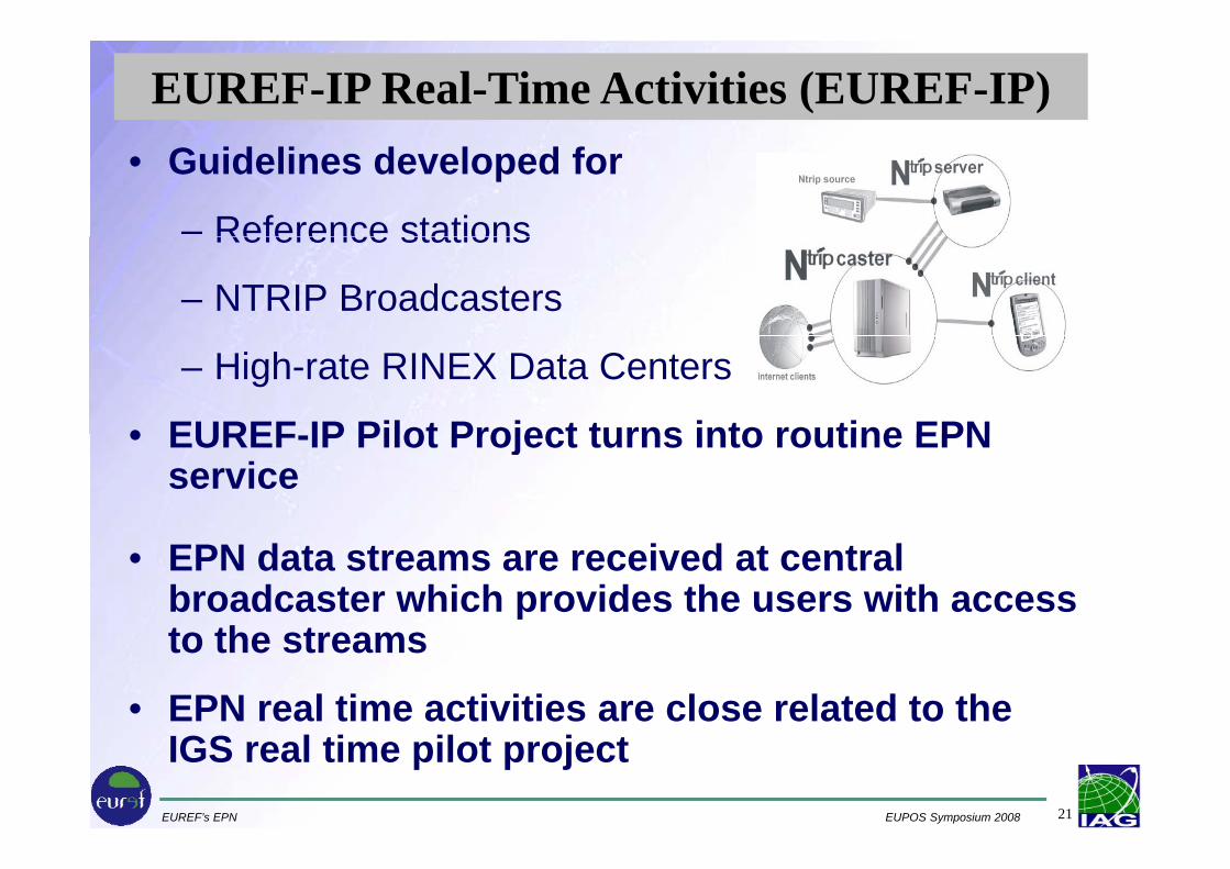
EUREF-IP Real-Time Activities (EUREF-IP)• Guidelines developed for
– Reference stationsReference stations
– NTRIP Broadcasters
– High-rate RINEX Data Centers
• EUREF IP Pilot Project turns into routine EPN• EUREF-IP Pilot Project turns into routine EPN service
• EPN data streams are received at central broadcaster which provides the users with access t th tto the streams
• EPN real time activities are close related to the
EUREF’s EPN EUPOS Symposium 2008 21
IGS real time pilot project

EUREF Real-Time GNSS Product Area
Satellite Clocks
Satellite Orbits
Troposphere
EphemeridesRaw Streams
RTIGS St
RealTime Space Weather
Ionosphere
ConversionDecoding &
RTIGS Streams
TimeGNSSEngine
Space Weather
Satellite Health
ConversionProducts
Decoding &Synchronization
RTCM 3 Streams
EngineInterference
Geodynamics
RTCM 2.x Streams Natural Hazards
Networked DGNSS
EUREF’s EPN EUPOS Symposium 2008 22
Networked RTK
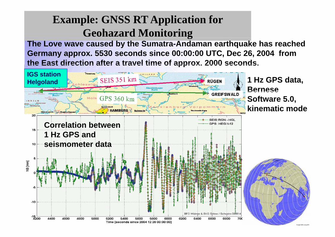
Example: GNSS RT Application for Geohazard Monitoringg
The Love wave caused by the Sumatra-Andaman earthquake has reached Germany approx. 5530 seconds since 00:00:00 UTC, Dec 26, 2004 from the East direction after a travel time of approx. 2000 seconds.IGS station Helgoland
the East direction after a travel time of approx. 2000 seconds.
1 Hz GPS data, BerneseBernese Software 5.0, kinematic mode
Correlation between 1 Hz GPS and seismometer dataseismometer data
EUREF’s EPN EUPOS Symposium 2008 23

Information System (ISO Registry) for European Coordinate Reference Systems (CRS)
CRSInformation System
for European Coordinate Reference Systems (CRS)
CRS CRS
http://crs.bkg.bund.de/crs-eu
Content nationalCRS
pan-EuropeanCRS
Description Overview
References
Europeancountries
CRS
Europe
CRSLinks
Contact
Description ofCRS
Parameterfor transform.
to pan European
Onlinetransformation
Description ofpan-European
CRS
Contact
to pan-EuropeanCRS
CRS
Following ISO 19111 (2003): Spatial referencing by coordinates
EUREF’s EPN EUPOS Symposium 2008 24
Available at: http://crs.bkg.bund.de/crs-euFollowing ISO 19111 (2003): Spatial referencing by coordinates

EUREF(4) Summary
EUREF
• is the key organization for the support of theis the key organization for the support of the geodetic GNSS ground based infra-structure in Europe- GNSS, Height and Gravity reference frames –
• established a working group to for definition and realization of continental geodetic reference system
• takes over geodetic tasks of EuroGeographics – the European legal entity of more than 50 European NMCA’s i th 40 t tin more than 40 states
• supports the IAG (IGS, GGOS, …) items in EUROPE and ill t i l b i t t t i thwill certainly be an important partner in the
implementation of INSPIRE (EC), GGOS (IAG), GEOSS (GEO)
EUREF’s EPN EUPOS Symposium 2008 25www.euref-iag.net www.euref.eu

EUREF & EUPOS
• Invitation to EUPOS to join EUREF annual symposiasymposia
• Cooperation in scientific aspects forCooperation in scientific aspects for investigations of geodynamical features in Europe (recent crustal movements, vertical,Europe (recent crustal movements, vertical, horizontal)
• Cooperation in the area of realization of continental geodetic reference systems
• Common contributions to environment and it i E
EUREF’s EPN EUPOS Symposium 2008 26
security in Europe