Development of Road Maintenance Inventory in UKM by Using ... · dicipta untuk menganalisis dan...
6
Jurnal Kejuruteraan SI 1(2) 2018: 73-78 http://dx.doi.org/10.17576/jkukm-2018-si1(2)-09 Development of Road Maintenance Inventory in UKM by Using Aerial Images (Pembangunan Inventori Penyelenggaraan Jalan Raya di UKM dengan Menggunakan Aerial Imej) Fifi Susanti Sjafri a , Khairul Nizam Abdul Maulud a,b,c * a Civil Engineering Programme, b Smart and Sustainable Township Research Centre (SUTRA), Faculty of Engineering and Built Environment, Universiti Kebangsaan Malaysia, Bangi, Malaysia Wan Shafrina Wan Mohd Jaafar c , Faiz Arif c , Abdul Aziz Ab Rahman c c Earth Observation Centre, Institute of Climate Change, Universiti Kebangsaan Malaysia Bangi, Malayisa Muhammad Mukhlisin d d Department of Civil Engineering, Politeknik Negeri Semarang, JI. Prof. Sudarto, SH. Tembalang, Semarang, Central Java, Indonesia ABSTRACT Nowadays, all data and information management is conducted in integrated digital form. The same goes for inventory management of road maintenance to ensure the updated road information. Geographical Information System (GIS) is a powerful application and able to analyse and store all the geospatial data. The objective of this study is to identify the physical condition of the roads in UKM based on information from the unmanned aerial vehicle (UAV) technology, to produce spatial data storage of road distresses and to analyse the frequency of road distress in UKM. This study was carried out in the field and a desktop study. The results of the study proved that there is road damage occurring repeatedly in the same location yearly. The results from UAV found that in a period of one year, the types of distresses decrease from 11 types to 5 types, where patching is the highest occurring road distress. Lingkungan Ilmu indicates the highest number of road distress occurring along the period at 63 distresses in 2015 and 15 distresses in 2016. All the recorded information can be stored easily by using geospatial technology. This study shows that UAV and GIS are utilisable in maintaining road inventory management. Keywords: Geospatial; Road distress; UAV technology; Road management; Inventory management ABSTRAK Pada masa kini, semua pengurusan data dan maklumat diuruskan oleh komputer. Perkara yang sama juga berlaku kepada pengurusan inventori penyelenggaraan jalan untuk memastikan maklumat jalan raya yang terkini. Terdapat pelbagai sistem dicipta untuk menganalisis dan menyimpan data. Salah satu sistem yang bertenaga adalah Sistem Maklumat Geografi (GIS). Objektif kajian adalah untuk memastikan keadaan fizikal jalan di UKM berdasarkan kepada maklumat yang diperolehi dari teknologi kenderaan udara tanpa pemandu (UAV) yang mana berfungsi untuk menghasilkan data spatial kerosakan jalan dengan menggunakan pendekatan spatial dan menganalisis kekerapan kerosakan jalan di UKM. Kajian ini dijalankan melalui dua pendekatan iaitu kajian di lapangan dan kajian destop. Hasil kajian membuktikan terdapat kerosakan jalan dalam tempoh satu tahun pemantauan. Hasil kajian juga menunjukkan dalam masa satu tahun, jumlah kerosakan jalan telah berkurangan dari 11 jenis kepada 5 jenis di mana kerosakan berbentuk menampal adalah jenis kerosakan yang tertinggi. Lingkungan Ilmu menunjukkan nilai yang tertinggi iaitu sebanyak 63 kerosakan dalam tahun 2015 dan 15 kerosakan dalam tahun 2016. Keseluruhan maklumat dapat disimpan dengan mudah dengan menggunakan kaedah teknologi geospatial. Kajian membuktikan bahawa teknologi UAV dan GIS mampu digunakan dalam pengurusan inventori jalan raya. Kata kunci: Geospatial; Kerosakan jalan; Teknologi UAV; Pengurusan jalan; Pengurusan inventori INTRODUCTION Road maintenance means all work involved in the purpose of maintaining the road condition as its original condition in terms of geometric characteristics as well as structural strength. The main objective of road maintenance is to reduce the rate of damage or road failure. In fact, maintenance can also reduce the operating costs of vehicles using the road by providing a good road surface. Furthermore, it also provides comfort and security for all the road users. Road maintenance can be divided into two types, which is regular maintenance and periodic maintenance. Recently, Unmanned Aerial Vehicle (UAV) application was an important tool especially during and after the development stages (Bryson & Sukkarieh 2009). The UAV can be flown at either high or low altitude (Nega et al. 2015; Udin & Ahmad 2014). Low altitude systems is an aerial imaging and capable to capture the image in a cloudy environment,
Transcript of Development of Road Maintenance Inventory in UKM by Using ... · dicipta untuk menganalisis dan...

Jurnal Kejuruteraan SI 1(2) 2018: 73-78http://dx.doi.org/10.17576/jkukm-2018-si1(2)-09
Development of Road Maintenance Inventory in UKM by Using Aerial Images
(Pembangunan Inventori Penyelenggaraan Jalan Raya di UKM dengan Menggunakan Aerial Imej)
Fifi Susanti Sjafria, Khairul Nizam Abdul Mauluda,b,c*aCivil Engineering Programme,
bSmart and Sustainable Township Research Centre (SUTRA), Faculty of Engineering and Built Environment, Universiti Kebangsaan Malaysia, Bangi, Malaysia
Wan Shafrina Wan Mohd Jaafarc, Faiz Arifc, Abdul Aziz Ab Rahmanc
cEarth Observation Centre, Institute of Climate Change, Universiti Kebangsaan Malaysia Bangi, Malayisa
Muhammad Mukhlisind
dDepartment of Civil Engineering, Politeknik Negeri Semarang, JI. Prof. Sudarto, SH. Tembalang, Semarang, Central Java, Indonesia
ABSTRACT
Nowadays, all data and information management is conducted in integrated digital form. The same goes for inventory management of road maintenance to ensure the updated road information. Geographical Information System (GIS) is a powerful application and able to analyse and store all the geospatial data. The objective of this study is to identify the physical condition of the roads in UKM based on information from the unmanned aerial vehicle (UAV) technology, to produce spatial data storage of road distresses and to analyse the frequency of road distress in UKM. This study was carried out in the field and a desktop study. The results of the study proved that there is road damage occurring repeatedly in the same location yearly. The results from UAV found that in a period of one year, the types of distresses decrease from 11 types to 5 types, where patching is the highest occurring road distress. Lingkungan Ilmu indicates the highest number of road distress occurring along the period at 63 distresses in 2015 and 15 distresses in 2016. All the recorded information can be stored easily by using geospatial technology. This study shows that UAV and GIS are utilisable in maintaining road inventory management.
Keywords: Geospatial; Road distress; UAV technology; Road management; Inventory management
ABSTRAK
Pada masa kini, semua pengurusan data dan maklumat diuruskan oleh komputer. Perkara yang sama juga berlaku kepada pengurusan inventori penyelenggaraan jalan untuk memastikan maklumat jalan raya yang terkini. Terdapat pelbagai sistem dicipta untuk menganalisis dan menyimpan data. Salah satu sistem yang bertenaga adalah Sistem Maklumat Geografi (GIS). Objektif kajian adalah untuk memastikan keadaan fizikal jalan di UKM berdasarkan kepada maklumat yang diperolehi dari teknologi kenderaan udara tanpa pemandu (UAV) yang mana berfungsi untuk menghasilkan data spatial kerosakan jalan dengan menggunakan pendekatan spatial dan menganalisis kekerapan kerosakan jalan di UKM. Kajian ini dijalankan melalui dua pendekatan iaitu kajian di lapangan dan kajian destop. Hasil kajian membuktikan terdapat kerosakan jalan dalam tempoh satu tahun pemantauan. Hasil kajian juga menunjukkan dalam masa satu tahun, jumlah kerosakan jalan telah berkurangan dari 11 jenis kepada 5 jenis di mana kerosakan berbentuk menampal adalah jenis kerosakan yang tertinggi. Lingkungan Ilmu menunjukkan nilai yang tertinggi iaitu sebanyak 63 kerosakan dalam tahun 2015 dan 15 kerosakan dalam tahun 2016. Keseluruhan maklumat dapat disimpan dengan mudah dengan menggunakan kaedah teknologi geospatial. Kajian membuktikan bahawa teknologi UAV dan GIS mampu digunakan dalam pengurusan inventori jalan raya.
Kata kunci: Geospatial; Kerosakan jalan; Teknologi UAV; Pengurusan jalan; Pengurusan inventori
INTRODUCTION
Road maintenance means all work involved in the purpose of maintaining the road condition as its original condition in terms of geometric characteristics as well as structural strength. The main objective of road maintenance is to reduce the rate of damage or road failure. In fact, maintenance can also reduce the operating costs of vehicles using the road by providing a good road surface. Furthermore, it also provides
comfort and security for all the road users. Road maintenance can be divided into two types, which is regular maintenance and periodic maintenance.
Recently, Unmanned Aerial Vehicle (UAV) application was an important tool especially during and after the development stages (Bryson & Sukkarieh 2009). The UAV can be flown at either high or low altitude (Nega et al. 2015; Udin & Ahmad 2014). Low altitude systems is an aerial imaging and capable to capture the image in a cloudy environment,

74
low-cost supplying, providing different views and tilted images of the surveyed object and easy-to-maintain for engineering application systems such as topographic survey and mapping (Saha & Ksaibati 2015).
A comprehensive fully integrated Pavement Maintenance and Management Systems (PMMS), is a comprehensive system and able to reconstruction, restoration and maintenance the pavements (Burrough, 1986; Al-Ajami 015). The best road preservation projects were important to enhance the quality and reduce the cost and provide the most benefit to the society. (Darwin & Ahmad 2014). To verify long-term pavement performance; it is important for predicting pavement temperature, detecting the pavement distress, and calculating the cost analysis of all the pavement distress (Chen et al. 2010; Sorum et al. 2013; Nega et al. 2015).
GIS able to improve the management operation by using the spatial analysis tools which is matching the geographical nature of road networks (Nasir et al. 2016; Fendi et al. 2014). Local authorities implement the GIS in managing the pavement activities and it’s proven and helpful in resolving the road problems. Besides that, geospatial technologies capable to enhance the analysis especially in transportation issues and
perform the best decision-making process by improving the quality. The definition for the GIS is an integrated method for collecting, storing, retrieving, analysing and displaying all the real spatial data for a set of specific purposes (Ibraheem & Falih 2006; Maulud et al. 2017).
The main purposes of the study are identifying the physical condition of road networks in UKM based on information from UAV. All the captured road distresses data was stored in an integrated geodatabase. The study able to determines the hotspot location for road distresses in UKM throughout one-year period of maintenance.
METHODOLOGY
The process of collecting data to determine the road distresses in the UKM is done by digitising the distresses using ArcMap 10.2 based on UAV image obtained from the Earth Observation Centre (EOC), UKM. The distress was digitised on eight main roads in the UKM which are Lingkungan Johan, Jalan Syed Nasir, Lingkungan Ilmu, Jalan Bunga Raya, Jalan Nik Ahmed Kamil, Jalan Temuan, Jalan Tun Ismail Ali, and Persiaran Tun Ismail Ali (Figure 1).
FIGURE 1. Study area in UKM (Source: Earth Observation Centre)
To obtain the accurate location and distress, the planning process must be done carefully starting from the distress digitizing until the map for hotspot locations of distress is created. Next, after the process of digitizing is done, site validation must be conduction for the distress marks. The purpose of site validation is to make sure that the marking points in the ArcGIS 10.2 are really distressed in a real condition. Besides that, site validation may provide the information for the types of distress, location of distress and area of the distresses (Nur Mustakiza Zakaria et al. 2015).
Data from a case study in 2015 is used to obtain information about the history of the road distress (Nasir et al. 2016). Then, the data will be overlapped with the latest data obtained from the digitized UAV image in 2016 which will be compared. Both of these data will be compared with the maintenance data from the Prasarana UKM, to locate the hotspot location of the road distresses. The analysis of hotspot location is only conducted for Lingkungan Ilmu road and Lingkungan Ke-2 road in UKM (Figure 2). Figure 3 and Figure 4 shows the capability of the UAV in identifying the location of road distress.

75
FIGURE 2. The hotspot location of distress in UKM on 2015 and 2016
FIGURE 4. Road distress identified by UAV image
FIGURE 3. Road distress identified by UAV image
76
ArcGIS software able to digitize the information from UAV and performs the analysis. GIS allows the user to interpret, trace and visualise data in the ways in establishing the trends, pattern and relationships in the form of reports charts and maps (Darwin & Ahmad, 2014). In the other words, GIS able to solve the integrated and temporal data in order to comprehend the outcomes.
RESULTS AND DISCUSSION
HOTSPOT ROAD DISTRESS IN UKM
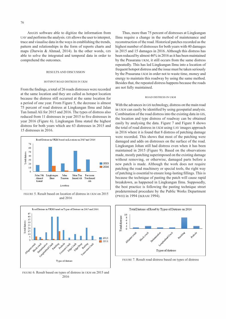
From the findings, a total of 26 roads distresses were recorded at the same location and they are called as hotspot location because the distress still occurred at the same location for a period of one year. From Figure 5, the decrease is almost 75 percent of road distress at Lingkungan Ilmu and Jalan Tun Ismail Ali for 2015 and 2016. The types of distress also reduced from 11 distresses in year 2015 to five distresses in year 2016 (Figure 6). Lingkungan Ilmu stated the highest distress for both years which are 63 distresses in 2015 and 15 distresses in 2016.
Thus, more than 75 percent of distresses at Lingkungan Ilmu require a change in the method of maintenance and reconstruction of the road. Historical patches recorded as the highest number of distresses for both years with 40 damages in 2015 and 15 damages in 2016. Although this distress has been reduced by almost 46% in 2016 as it has been maintained by the Prasarana UKM, it still occurs from the same distress repeatedly. This has led Lingkungan Ilmu into a location of frequent hotspot distress and the issue must be taken seriously by the Prasarana UKM in order not to waste time, money and energy to maintain this roadway by using the same method. Besides that, the repeated distress happens because the roads are not fully maintained.
ROAD DISTRESS IN UKM
With the advances in GIS technology, distress on the main road in UKM can easily be identified by using geospatial analysis. Combination of the road distress into the existing data in GIS, the location and type distress of roadway can be obtained easily by analysing the data. Figure 7 and Figure 8 shows the total of road distress in UKM using UAV images approach in 2016 where it is found that 8 distress of patching damage were recorded. This shows that most of the patching were damaged and adds on distresses on the surface of the road. Lingkungan Johan still had distress even when it has been maintained in 2015 (Figure 9). Based on the observations made, mostly patching superimposed on the existing damage without removing, or otherwise, damaged parts before a new patch is made. Although the work does not require patching the road machinery or special tools, the right way of patching is essential to ensure long-lasting fillings. This is because the technique of pasting the patch will cause rapid breakdown, as happened in Lingkungan Ilmu. Supposedly, the best practice is following the pasting technique street predetermined procedure by the Public Works Department (PWD) in 1994 (IKRAM 1994). FIGURE 5. Result based on location of distress in UKM on 2015
and 2016
FIGURE 6. Result based on types of distress in UKM on 2015 and 2016
FIGURE 7. Result road distress based on types of distress

77
CONCLUSION
Before any decision to be performed, the causes of damages should be analysed and evaluated in advance to ensure comfort and safety for road users. Among the causes of road damages in UKM is due to the heavy traffic, land topography and the pavement condition itself. Proper maintenance followed by comprehensive guideline should be done properly to avoid wasting time and money for repairing the same damage repeatedly. Managing road maintenance by using GIS approach is the best approach for future maintenance management. GIS is not limited to the use of road damages management but also be applied to other systems as well as sewage systems, waste management and other utilities. In short, GIS is a system designed to help users in recording, analysing, problems solving and data store for current and future users. The combined data obtained into the GIS has succeeded in producing an analysis map and displaying the actual location of recurrent road damages. In addition, the main road damage analysis map has been developed with the UAV technology. The production of analytical map based on GIS able to improve the process for managing road pavement maintenance from the system of data collection and storage of road damage to the priority determination of road improvements.
FIGURE 8. Result road distress based on location
FIGURE 9. Data maintenance on Lingkungan Johan in year 2015
ACKNOWLEDGEMENT
The authors would like to thank the Universiti Kebangsaan Malaysia for the research university research grant Top Down, TD-2016-012 and Strategic Research Grant, KRA-2018-019 for the financial support. All authors also would like to thank Earth Observation Centre (EOC) and Prasarana UKM for the cooperation and information the success of these studies.
REFERENCES
Al-Ajami, H. 2015. Pavement maintenance management systems. Civil and Environmental Research 7(5): 108-115.
Burrough, P. A. 1986. Principle of Geographic Information System for Land Resource Assessment. Oxford; Clarendon Press.
Bryson, M. & Sukkarieh, S. 2009. Archietecture for cooperative airbone simulataneous localization and mapping. Journal of Intelligent Robort System 55: 267-297.
Darwin, N. & Ahmad, A. 2014. The potential of low Altitude Aerial data for large scale mapping. Jurnal Teknologi (Science & Technology) 70(5): 109-115.
Chen H. Y., Yong C. C. & Yang Q. C. 2010. Autopilots for small unmanned aerial vehicles: A survey. International Journal of Control, Automation and Systems 8(1): 36-44.
Fendi, K. G., Adam, S. M., Kokkas, N. & Smith, M. 2014. An approach to produce a GIS database for road surface monitoring. APCBEE Procedia 9: 235-240.
Ibraheem, A. & Falih, D. 2006. Applying Geographic Information System (GIS) for maintenance strategy selection. Journal of Intelligent Robort System 55: 267-297.
Institut Kerja Raya Malaysia (IKRAM). Interim Guide to Evaluation and Rehabilitation of Flexible Road Pavements. Jabatan Kerja Raya, 1994 IKRAM Series (Pavement), ISP-2: 5.18
Maulud, K.N.M., Karim, O.A. & Lee, A.S.P. 2017. Study the potential of marine energy in the coastal of Selangor and Perak, Jurnal Kejuruteraan Special Issue 1: 15-23.
Nasir, N.A.M., Maulud, K.N.A. & Yusoff, N.I.M. 2016. Geospatial analysis of road distresses and the relationship with the slope factor. Journal of Engineering Science and Technology 11(5): 655-665.
Nega, A., Nikraz, H., Herath, S. & Ghadami, B 2015. Distress identification, cost analysis and pavement temperature prediction for the long-term pavement performance for Western Australia. International Journal of Engineering and Technology 7(4): 267-275.
Nur Mustakiza Zakaria, Muhammad Fakhry Md. Jaffary, Muhammad Kamal Hassan, Asmah Hamim, Nur Izzi Md. Yusoff, Khairul Anuar Mohd Nayan. 2015. Penentuan sifat kekukuhan dan ketebalan lapisan permukaan berasfalt menggunakan kaedah Pencarian Resonan Tambahan (ERS). Jurnal Teknologi 76(1): 15-23.

78
Saha, P. & Ksaibati, K. 2016. A risk-based optimisation methodology for pavement management system of county roads, International Journal of Pavement Engineering 17(10): 913-923.
Udin, W. S. & Ahmad, A. 2014. Assessment of photogrammetric mapping accuracy based on variation flying altitude using unmanned aerial vehicle. IOP Conference Series: Earth and Environmental Science 18: 012027.
Sorum, N. G. Guite, T. & Martina, N. 2013. Pavement distress: A case study. International Journal of Innovation Research in Science, Engineering and Technology 3(4): 274-284.
*Corresponding author; email: [email protected]
Fifi Susanti Sjafri, *Khairul Nizam bin Abdul MauludCivil Engineering Programme, Smart and Sustainable Township Research Centre, Faculty of Engineering and Built Environment, Universiti Kebangsaan Malaysia, Bangi, Malaysia
*Khairul Nizam bin Abdul Maulud, Wan Shafrina Wan Mohd Jaafar, Faiz Arif, Abdul Aziz Ab Rahman, Earth Observation Centre (EOC), Institute of Climate Change,Universiti Kebangsaan Malaysia, Bangi, Malaysia
Muhammad MukhlisinDepartment of Civil Engineering, Politeknik Negeri Semarang, JI. Prof. Sudarto, SH. Tembalang, Semarang, Central Java, Indonesia Received date: 22nd May 2018Accepted date: 15th August 2018Online First date: 1st October 2018Published date: 30th November 2018