Developing Java Applications with the Enterprise ADF · Developing JavaTM Applications with the...
45
TM TM Developing Java Developing Java TM TM Applications with the Applications with the Enterprise ADF Enterprise ADF Di hG l Di hG l Divesh Goyal Divesh Goyal Eric Bader Eric Bader 1
Transcript of Developing Java Applications with the Enterprise ADF · Developing JavaTM Applications with the...

TMTMDeveloping JavaDeveloping JavaTMTM Applications with the Applications with the Enterprise ADFEnterprise ADF
Di h G lDi h G lDivesh Goyal Divesh Goyal Eric Bader Eric Bader
11

Key Objectives of This PresentationKey Objectives of This Presentation
•• Help You Answer:Help You Answer:What Why and How on ADF’s EJBWhat Why and How on ADF’s EJBTMTM componentscomponents–– What, Why, and How on ADF s EJBWhat, Why, and How on ADF s EJB componentscomponents
–– How does ADF support development of Geospatial Java How does ADF support development of Geospatial Java Enterprise (EE) applications?Enterprise (EE) applications?
–– What are the workflow steps for building Geospatial Java EE What are the workflow steps for building Geospatial Java EE applications? applications?
–– Are there any nuances? If so, what are they?Are there any nuances? If so, what are they?y , yy , y–– What are the development patterns for programming to the What are the development patterns for programming to the
Geospatial EJBs?Geospatial EJBs?What resources are recommended and available for a JavaWhat resources are recommended and available for a Java–– What resources are recommended and available for a Java What resources are recommended and available for a Java developer who is new to ESRI technology?developer who is new to ESRI technology?
22

AgendaAgenda
•• IntroductionIntroduction•• Inside the Enterprise Application Developer FrameworkInside the Enterprise Application Developer Framework•• Inside the Enterprise Application Developer Framework Inside the Enterprise Application Developer Framework •• ArchitectureArchitecture•• WorkflowWorkflow•• WorkflowWorkflow•• Programming models and scenariosProgramming models and scenarios•• Application DeploymentApplication Deployment•• Application DeploymentApplication Deployment•• Learning resourcesLearning resources•• SummarySummarySummarySummary
33

OverviewOverview
ArcGIS Server (Java) includes framework to build and deploy GISArcGIS Server (Java) includes framework to build and deploy GIS--enabled J2EE applications using Enterprise JavaBeans technology enabled J2EE applications using Enterprise JavaBeans technology pp g p gypp g p gy(EJB)(EJB)
•• OutOut ofof thethe box EJBs that perform GIS tasksbox EJBs that perform GIS tasks•• OutOut--ofof--thethe--box EJBs that perform GIS tasksbox EJBs that perform GIS tasks–– Mapping, Geocoding, Geodata Querying, Geoprocessing, Network Mapping, Geocoding, Geodata Querying, Geoprocessing, Network
solvingsolvingD l d id i t f J2EE 1 4 tifi d li tiD l d id i t f J2EE 1 4 tifi d li ti•• Deployed across a wide variety of J2EE 1.4 certified application Deployed across a wide variety of J2EE 1.4 certified application servers servers ---- such as BEA, Oracle, IBM, JBoss, and Sunsuch as BEA, Oracle, IBM, JBoss, and Sun
•• Integrated into Manager Application for simple point click easeIntegrated into Manager Application for simple point click ease•• Focus on generated applications and not coded applicationsFocus on generated applications and not coded applications•• High PerformanceHigh Performance
44

Understanding EJBsUnderstanding EJBs
•• Enterprise JavaBeans (EJB )Enterprise JavaBeans (EJB )An architecture for developing secure transactional applicationsAn architecture for developing secure transactional applications–– An architecture for developing secure transactional applications An architecture for developing secure transactional applications as distributed components in Javaas distributed components in Java
•• ServerServer--side Componentsside Components•• Clients can be:Clients can be:
–– Standalone desktop applications (ClientStandalone desktop applications (Client--server)server)–– Web Applications (Servlets/JSPs/Web Services)Web Applications (Servlets/JSPs/Web Services)–– Other EJBs (remote or local)Other EJBs (remote or local)
55

EJB AdvantagesEJB Advantages
•• AdvantagesAdvantages–– One source for business logicOne source for business logic–– Accessible by many types of clientsAccessible by many types of clients–– Integrates well with other systemsIntegrates well with other systemsIntegrates well with other systemsIntegrates well with other systems–– Clear separation of business from client tierClear separation of business from client tier–– Easily distributedEasily distributed
66

What’s inside the Enterprise ADF?What’s inside the Enterprise ADF?•• EJBs: PreEJBs: Pre--packaged, ready for configuringpackaged, ready for configuring
–– MappingMapping–– GeocodingGeocoding–– GeoprocessingGeoprocessing–– Network AnalysisNetwork Analysis
•• API: a pure Java libraryAPI: a pure Java library–– Packaged in:Packaged in: com.esri.arcgisws.*com.esri.arcgisws.*
•• Java EE standard Resource AdaptorJava EE standard Resource AdaptorO ti lO ti l–– OptionalOptional
–– Provided for strict J2EE compliancy when connecting to ArcGIS ServerProvided for strict J2EE compliancy when connecting to ArcGIS Server
•• SDK: Documentation and Sample client applications SDK: Documentation and Sample client applications –– Demonstrate best practices and recommended development patternsDemonstrate best practices and recommended development patterns
•• Eclipse IDE IntegrationEclipse IDE Integration
77
•• Manager IntegrationManager Integration
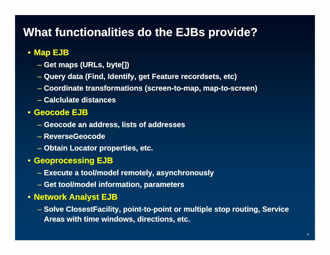
What functionalities do the EJBs provide?What functionalities do the EJBs provide?•• Map EJBMap EJB
–– Get maps (URLs, byte[])Get maps (URLs, byte[])–– Query data (Find, Identify, get Feature recordsets, etc)Query data (Find, Identify, get Feature recordsets, etc)Q y ( , y, g , )Q y ( , y, g , )–– Coordinate transformations (screenCoordinate transformations (screen--toto--map, mapmap, map--toto--screen)screen)–– Calclulate distancesCalclulate distances
•• Geocode EJBGeocode EJB•• Geocode EJBGeocode EJB–– Geocode an address, lists of addressesGeocode an address, lists of addresses–– ReverseGeocodeReverseGeocode–– Obtain Locator properties, etc.Obtain Locator properties, etc.
•• Geoprocessing EJBGeoprocessing EJB–– Execute a tool/model remotely, asynchronouslyExecute a tool/model remotely, asynchronouslyy, y yy, y y–– Get tool/model information, parametersGet tool/model information, parameters
•• Network Analyst EJBNetwork Analyst EJBSolve ClosestFacility pointSolve ClosestFacility point toto point or multiple stop routing Servicepoint or multiple stop routing Service
88
–– Solve ClosestFacility, pointSolve ClosestFacility, point--toto--point or multiple stop routing, Service point or multiple stop routing, Service Areas with time windows, directions, etc.Areas with time windows, directions, etc.

ArchitectureArchitecture
A li ti SA li ti S
EIS TierEIS TierEJB TierEJB TierClient TierClient Tier
erer
Application ServerApplication Server
EJB ContainerEJB ContainerJNDIJNDI
1.1. lookuplookup
2. Return Home 2. Return Home Object ReferenceObject Reference erer
ArcGIS ArcGIS ServerServerur
ceur
ceA
dapt
eA
dapt
e
EJBEJBEJB HomeEJB Home
Hom
eH
omeObject ReferenceObject Reference
3. Use Home 3. Use Home to create EJBto create EJB
Home Home StubStub
Home InterfaceHome Interface
urce
urce
Ada
pte
Ada
pte
EJBEJB ClientClient ServerServer
Res
ouR
esou
EJB ObjectEJB Object
Rem
ote
Rem
ote
5. Invoke Business5. Invoke BusinessMethodMethod
EJB Object EJB Object StubStub
Remote InterfaceRemote Interface
ArcObject ArcObject COMCOM
4. Returns EJB 4. Returns EJB Object ReferenceObject Reference
Local EJBLocal EJB
Res
ouR
esou
EJB EJB ClientClient
jjMethodMethod COM COM ComponentsComponents
IntraIntra--vm optimizations vm optimizations (EJB Client/Bean co(EJB Client/Bean co--located in same VM)located in same VM)
99
(EJB Client/Bean co(EJB Client/Bean co--located in same VM)located in same VM)

Typical J2EE Use Case Scenario in GIS spaceTypical J2EE Use Case Scenario in GIS spaceCC P t tiP t ti
A li ti SA li ti S
EIS TierEIS TierBusiness Business EJB TierEJB Tier
Client Client TierTier
Presentation Presentation Web TierWeb Tier
Application ServerApplication Server
EJB EJB C t iC t i
JNDIJNDI
Application Application ServerServer
Servlet/JSP Servlet/JSP C t iC t i ContainerContainer
EJBEJBHom
eH
ome
ClientClient EJBEJB
ContainerContainer
ServletsServletsDatabasesDatabases
JCA
JCA
Rem
ote
Rem
ote
ClientClient EJBEJB
EJBEJB
ServletsServletsJSPsJSPs
EJBEJB
1010
ArcGISArcGISServerServer

Invoking GIS operationsInvoking GIS operations
A li ti SA li ti S
EIS TierEIS TierEJB TierEJB TierClient TierClient Tier
RequestRequestResponse usingResponse using
Axis RuntimeAxis Runtime
Application ServerApplication Server
EJB ContainerEJB ContainerJNDIJNDI
Home InterfaceHome Interface
ArcGIS ArcGIS ServerServer
SOAP/DCOM SOAP/DCOM HandlerHandler
EJBEJBEJB HomeEJB Home
Hom
eH
ome
Home Home StubStub
EJBEJB ClientClient ServerServer
EJB ObjectEJB Object
Rem
ote
Rem
ote
EJB Object EJB Object StubStub
Remote InterfaceRemote Interface
ArcObject ArcObject COM COM Local EJBLocal EJB
EJB EJB ClientClient
SOAP/DCOMSOAP/DCOM
XML XML PayloadPayload
jj COCOComponentsComponents
1111

Certified J2EE 1.4 ContainersCertified J2EE 1.4 Containers
JBoss 4.0.2BEA WebLogic8.1 SP4 OracleAS10.1.2 (10g Release 2)
IBM WebSphere 5.1 Sun (SJSAS) 8.1
1212

ArcGIS Server 9.2
EJB Container EJB WorkflowEJB Workflow3.3. C fi ti d
Web ClientsArcGIS Server
Configuration and deployment
Web Server Web Server
4.4.
GIS ServerGIS Server
Manager2.2.Rich Clients
ArcCatalog Administration
Manager or
2.2.
A M A Gl b
Geodata
11
1313
ArcMap, ArcGlobe
Service Content Author
1.1.

Steps to Creating and Deploying EJBs (2.1)Steps to Creating and Deploying EJBs (2.1)
CreateCreateUse Manager Use Manager
Point Click EasePoint Click Ease Create Create Remote InterfaceRemote Interface
Point Click EasePoint Click Ease
Create Create Bean Home InterfaceBean Home Interface
Package and DeployPackage and Deploy
EJBEJBEJB EJB ContainerContainer
Write Bean Write Bean ImplementationImplementation
Create Create Deployment DescriptorDeployment Descriptor
1414

Building GeoSpatial EJBs with ManagerBuilding GeoSpatial EJBs with Manager
1515

Building GeoSpatial EJBs with EclipseBuilding GeoSpatial EJBs with Eclipse
Using the ArcGIS Server PluginsUsing the ArcGIS Server PluginsUsing the ArcGIS Server PluginsUsing the ArcGIS Server Plugins
1616

Programming Patterns and ScenariosProgramming Patterns and Scenarios
1717

EJB Business Case #1: EJB Business Case #1: Getting MapsGetting Maps
Client code development tasks…Client code development tasks…
1.1. Get a reference to the Get a reference to the Map EJBMap EJB through standard through standard JNDI l kJNDI l kJNDI lookupJNDI lookup
2.2. Get the Get the MapDescriptionMapDescription object from the Map EJBobject from the Map EJB33 Create theCreate the ImageDescriptionImageDescription andand ImageDisplaImageDispla3.3. Create the Create the ImageDescriptionImageDescription and and ImageDisplayImageDisplay
objects and set the appropriate propertiesobjects and set the appropriate properties44 Apply theApply the ImageDescriptionImageDescription andand ImageDisplayImageDisplay objectsobjects4.4. Apply the Apply the ImageDescriptionImageDescription and and ImageDisplayImageDisplay objects objects
to to MapDescriptionMapDescription5.5. Get the Get the MapImageMapImage object from the object from the Map EJBMap EJB using using
1818
p gp g jj pp ggMapDescriptionMapDescription objectobject

EJB Business Case #1: EJB Business Case #1: Getting MapsGetting Maps
// Get the Map EJBpmapContext = new InitialContext();Object ref = mapContext.lookup(mapJNDIName);MapEJBHome home = (MapEJBHome) PortableRemoteObject.narrow(ref,
MapEJBHome.class);mapEJB = home.create();
1919

EJB Business Case #1: EJB Business Case #1: Getting MapsGetting Maps
..// Get the MapDescriptionString defaultMapName = mapEJB.getDefaultMapName();mapDescription = mapEJB.getServerInfo(defaultMapName).getDefaultMapDescription();
// Create and prepare the ImageDescription, ImageType and ImageDisplayimageDescription = new ImageDescription();
ImageType type = new ImageType();type.setImageFormat(EsriImageFormat.esriImagePNG);type.setImageReturnType(EsriImageReturnType.esriImageReturnMimeData);
ImageDisplay display = new ImageDisplay(600, 600, 96);imageDescription.setImageDisplay(display);imageDescription.setImageType(type);
// Get the map image to be displayed in your client application…MapImage mapImage = mapEJB.exportMapImage(mapDescription, imageDescription);byte[] mimeData = mapImage.getImageData();..
2020

EJB Business Case #2: EJB Business Case #2: Querying Features within a FeatureLayerQuerying Features within a FeatureLayerQ y g yQ y g y
Client code development tasks…Client code development tasks…
1.1. Get a reference to the Get a reference to the Map EJBMap EJB through JNDI lookupthrough JNDI lookup2.2. Get theGet the LayerDescriptionLayerDescription object for the Layer to beobject for the Layer to be2.2. Get the Get the LayerDescriptionLayerDescription object for the Layer to be object for the Layer to be
queried. Use queried. Use MapDescriptionMapDescription to obtain it.to obtain it.3.3. Define a Define a SpatialFilterSpatialFilter to select Features with. Use to select Features with. Use
PolygonNPolygonN and and PointNPointN objects.objects.4.4. Call Call setWhereClause(String)setWhereClause(String) on the on the SpatialFilterSpatialFilter5.5. Define a selection symbol and set it to the Layer to Define a selection symbol and set it to the Layer to
be queried.be queried.66 E t th M IE t th M I
2121
6.6. Export the MapImageExport the MapImage

EJB Business Case #2: EJB Business Case #2: Querying Features within a FeatureLayerQuerying Features within a FeatureLayerQ y g yQ y g y
...
// Create and set the appropriate values for the SpatialFilter// Create and set the appropriate values for the SpatialFilter
SpatialFilter sf = new SpatialFilter();sf.setFilterGeometry(polygon);sf.setGeometryFieldName("SHAPE");sf.setWhereClause(""); //selects ALL features in the Layersf.setSearchOrder(EsriSearchOrder.esriSearchOrderAttribute);sf.setSpatialRelDescription("");sf.setSpatialRelDescription( );sf.setSpatialRel(EsriSpatialRelEnum.esriSpatialRelIntersects);
...
// #1: Query layer and set selected featuresFIDSet ifid = mapEJB.queryFeatureIDs(mapdesc.getName(), layer0.getLayerID(), sf);
layer0 setSelectionFeatures(ifid getFIDArray());
2222
layer0.setSelectionFeatures(ifid.getFIDArray());MapImage mapimg = mapEJB.exportMapImage(mapDesc, imageDesc);

EJB Business case #3: EJB Business case #3: Reverse GeocodeReverse Geocode
Client code development tasks…Client code development tasks…
1.1. Define and set input parameters using Define and set input parameters using PropertySetPropertySetdd P t S tP t []P t S tP t []and and PropertySetProperty[]PropertySetProperty[]
2.2. Create the point to geocode (Create the point to geocode (PointNPointN). Make sure the ). Make sure the correctcorrect SpatialReferenceSpatialReference is appliedis appliedcorrect correct SpatialReferenceSpatialReference is appliedis applied
3.3. Invoke the method call to the Invoke the method call to the Geocode EJBGeocode EJB using using the the PropertySetPropertySetp yp y
4.4. Process the resultsProcess the results
2323

EJB Business case #3: EJB Business case #3: Reverse GeocodeReverse Geocode
// Get a reference to the Geocode EJB..InitialContext context = new InitialContext();Object ref = context.lookup(“ejb/esri/GCEjb/Geocode”);Object ref context.lookup( ejb/esri/GCEjb/Geocode );GeocodeEJBHome home =
(GeocodeEJBHome) PortableRemoteObject.narrow(ref, GeocodeEJBHome.class);
geoEJB = home.create();g ()
2424

EJB Business case #3: EJB Business case #3: Reverse GeocodeReverse Geocode
// Define reverse GC inputsPropertySet geocodePropSet = new PropertySet();PropertySetProperty[] propArray = new PropertySetProperty[2];PropertySetProperty[] propArray = new PropertySetProperty[2];
PropertySetProperty geocodeProp = new PropertySetProperty();geocodeProp.setKey("ReverseDistanceUnits");geocodeProp.setValue("Meters");propArray[0] = geocodeProp;
PropertySetProperty geocodeProp1 = new PropertySetProperty();p y p y g p p y p y()geocodeProp1.setKey("ReverseDistance");geocodeProp1.setValue("100“);propArray[1] = geocodeProp1;
geocodePropSet.setPropertyArray(propArray);
2525

EJB Business case #3: EJB Business case #3: Reverse GeocodeReverse Geocode// Create point to reverse geocodePointN inputPoint = new PointN();
inputPoint.setX(7649794.0);pinputPoint.setY(677525.0);
// Point must be in the same coordinate system as locator
SpatialReference resultsr = null;Fields resultflds = geoEJB.getResultFields(geocodePropSet);
for(int i = 0;i < resultflds.getFieldArray().length;i++){Field fld = resultflds.getFieldArray()[i];if(fld.getType().getValue().equals("esriFieldTypeGeometry")){
resultsr = fld.getGeometryDef().getSpatialReference();}
}}
inputPoint.setSpatialReference(resultsr);
2626

EJB Business case #3: EJB Business case #3: Reverse GeocodeReverse Geocode// Do the Reverse Geocode and iterate through the results
PropertySet results = geoEJB reverseGeocode(inputPoint false geocodePropSet)geoEJB.reverseGeocode(inputPoint, false, geocodePropSet);
PropertySetProperty[] resultsArray = results.getPropertyArray();
for (int i = 0; i < resultsArray.length; i++) {PropertySetProperty result = resultsArray[i];System.out.println(result.getKey().toString());System.out.println(result.getValue().toString());System.out.println(result.getValue().toString());if (result.getValue() instanceof PointN) {
PointN geocodePoint = (PointN) result.getValue();double x = geocodePoint.getX();d bl d P i t tY()double y = geocodePoint.getY();System.out.println(x + ", " + y);
}}
2727

EJB Business Case #4: EJB Business Case #4: Buffering Features by calling a GP ModelBuffering Features by calling a GP Modelg y gg y g
Client code development tasks…Client code development tasks…
1.1. Get the tool names from the Get the tool names from the GP EJBGP EJB2.2. For each tool, get the For each tool, get the GPToolInfoGPToolInfo from the GP EJBfrom the GP EJB3.3. For each tool, get its For each tool, get its GPParameterInfoGPParameterInfoss4.4. Each parameter requires a specific Each parameter requires a specific GPValue GPValue type. For each type. For each
parameter, find out what the valid data type isparameter, find out what the valid data type is5.5. Set the appropriate values to each parameter for the tool to be Set the appropriate values to each parameter for the tool to be
executedexecuted6.6. Add each newly populated GPParameterInfo value to a Add each newly populated GPParameterInfo value to a y p py p p
GPValue[] GPValue[] arrayarray7.7. Submit the “Job” by calling the GP EJB to execute, passing Submit the “Job” by calling the GP EJB to execute, passing
the name of the tool and the GPValue[]. This can happen the name of the tool and the GPValue[]. This can happen
2828
[] pp[] ppasynchronouslyasynchronously
8.8. When the job finishes, do something with the resultWhen the job finishes, do something with the result

Get the EJB referencesGet the EJB references
// Get the GP Bean referencegpContext = new InitialContext();Object ref = gpContext.lookup(gpJNDIName);GeoprocessingEJBHome gpEJBHome = (GeoprocessingEJBHome) PortableRemoteObject.narrow(ref,GeoprocessingEJBHome.class);
gpEJB = gpEJBHome.create();
// Get the Map Bean referencemapContext = new InitialContext();Object ref = mapContext.lookup(mapJNDIName);MapEJBHome home = (MapEJBHome) PortableRemoteObject.narrow(ref,
M EJBH l )MapEJBHome.class);mapEJB = home.create();
2929

Set the parameters for the buffer model Set the parameters for the buffer model
// get the tool namesString[] toolNames = gpEJB.getToolNames();String executeTool = toolNames[1]; // this is the buffer tool
// get toolinfo, parameter info and initialize the parametersGPToolInfo toolInfo = gpEJB.getToolInfo(executeTool);GPParameterInfo[] paramInfo = toolInfo.getParameterInfo();
// There are 2 parameters for this toolGPValue[] values = new GPValue[paramInfo.length];
..
..if (paramInfo[i].getDataType().equalsIgnoreCase("GPFeatureRecordSetLayer")) {
GPFeatureRecordSetLayer gpFeatureRS = new GPFeatureRecordSetLayer();
// this is the recordset of features to buffer// this is the recordset of features to buffer…gpFeatureRS.setRecordSet(recordSet);
// Set value for the FIRST parameterparamInfo[i].setValue(gpFeatureRS);
3030
p [ ] (gp );}
values[i] = paramInfo[i].getValue();

Set the parameters for the buffer model Set the parameters for the buffer model
..
..// Deal with the second parameter…if (paramInfo[i].getDataType().equalsIgnoreCase("GPLinearUnit")) {
GPLinearUnit lu = new GPLinearUnit();lu.setUnits(EsriUnits.esriMiles);lu.setValue(distance);
// Set the value for the SECOND parameterparamInfo[i].setValue(lu);
}
values[i] = paramInfo[i].getValue();
3131

Execute the tool Execute the tool // j b d i// execute job and retrieve statusString jobID = gpEJB.submitJob(executeTool, values);
EsriJobStatus jobStatus = gpEJB.getJobStatus(jobID);
String status = jobStatus.getValue();
// wait till job execution succeedswhile (!status equalsIgnoreCase(EsriJobStatus esriJobSucceeded)) {while (!status.equalsIgnoreCase(EsriJobStatus._esriJobSucceeded)) {
Thread.sleep(1000);jobStatus = gpEJB.getJobStatus(jobID);status = jobStatus.getValue();
if (status.equalsIgnoreCase(EsriJobStatus._esriJobFailed)) {break;
}}
if (!status.equalsIgnoreCase(EsriJobStatus._esriJobSucceeded)) {jobID = null;
}
3232
return jobID;

EJB Business Case #5: EJB Business Case #5: Solve a simple route between 2 stops and generate Solve a simple route between 2 stops and generate p p gp p gdirectionsdirections
Client code development tasks…Client code development tasks…
1.1. Get references to Get references to GeocodeGeocode and and NANA EJBSEJBS2.2. Geocode “start” and “end” addressesGeocode “start” and “end” addresses2.2. Geocode start and end addressesGeocode start and end addresses3.3. Get the Get the PointNPointN for each (to be used as the “stops”)for each (to be used as the “stops”)4.4. Create Create NAServerRouteParamsNAServerRouteParams and and
add the “stops” to itadd the “stops” to it•• add the “stops” to itadd the “stops” to it•• Set “Return Directions” to be TRUESet “Return Directions” to be TRUE•• Set “Direction Distance Units”Set “Direction Distance Units”
S t “I d ” (Mi t ? M t ?)S t “I d ” (Mi t ? M t ?)•• Set “Impedance” (Minutes? Meters?)Set “Impedance” (Minutes? Meters?)5.5. Call Call solve (NAServerRouteParams)solve (NAServerRouteParams) on NA EJBon NA EJB6.6. Process the results (Process the results (NAServerRouteResultsNAServerRouteResults is returned from is returned from
S l )S l )
3333
Solve)Solve)

Geocode the “start” and “end” addressesGeocode the “start” and “end” addresses//Geocode STARTING address
Field[] addressFields = geoEJB.getAddressFields().getFieldArray();PropertySetProperty[] addressComponents = new PropertySetProperty[]{new
PropertySetProperty(), new PropertySetProperty()};
addressComponents[0].setKey(addressFields[0].getName());addressComponents[0].setValue(startAddress);addressComponents[1].setKey(addressFields[1].getName());addressComponents[1] setValue(startZone);addressComponents[1].setValue(startZone);PropertySet address = new PropertySet(addressComponents);
PointN startPoint = null;PointN endPoint = null;PointN endPoint null;
PropertySet gecodedAddress = geoEJB.geocodeAddress(address,null);PropertySetProperty[] geocodedComponents = gecodedAddress.getPropertyArray();
for(int i=0;i<geocodedComponents.length;i++){if(geocodedComponents[i].getKey().equals("Shape")){
startPoint = (PointN)geocodedComponents[i].getValue();break;
3434
}// DO THE SAME FOR THE ENDING ADDRESS

Prepare the Route Parameters...Prepare the Route Parameters...//Find route. First, set the Route ParametersNAServerRouteParams routeParams = (NAServerRouteParams)naEJB.getNASolverParameters(routeLayer);
NAServerPropertySets stops = new NAServerPropertySets();PropertySet[] pitStops =
new PropertySet[] {new PropertySet(), new PropertySet()};
pitStops[0].setPropertyArray(new PropertySetProperty[] {new PropertySetProperty("Name", startAddress),new PropertySetProperty("X", String.valueOf(startPoint.getX())),new PropertySetProperty("Y", String.valueOf(startPoint.getY()))});
pitStops[1].setPropertyArray(new PropertySetProperty[] {new PropertySetProperty("Name", endAddress),
P t S tP t ("X"new PropertySetProperty("X", String.valueOf(endPoint.getX())),new PropertySetProperty("Y", String.valueOf(endPoint.getY()))});
stops setPropertySets(pitStops);
3535
stops.setPropertySets(pitStops);routeParams.setStops(stops);routeParams.setReturnDirections(true);

Solve the Route...Solve the Route...
...
// Solve RouteNAServerRouteResults results =NAServerRouteResults results =
(NAServerRouteResults)naEJB.solve (routeParams);
// Iterate through the resulting direction components (Text directions etc// Iterate through the resulting direction components (Text directions, etc...NAStreetDirections[] directions = results.getDirections();
3636

Network Analyst EJB DemoNetwork Analyst EJB Demo
3737

Integration with Web ADFIntegration with Web ADF
•• The Java Web ADF API includes:The Java Web ADF API includes:EJBMapResourceEJBMapResource–– EJBMapResourceEJBMapResource
–– EJBGeocodeResourceEJBGeocodeResource
•• To add an EJB as a Map or Geocode resource to your To add an EJB as a Map or Geocode resource to your p yp yADF Web Application:ADF Web Application:–– Modify the Modify the WEBWEB--INF/facesINF/faces--config.xmlconfig.xml
–– Include a Include a “managed“managed--bean” bean” for each EJBfor each EJB–– Define Define “managed properties”“managed properties” for jndiNames and any RMI for jndiNames and any RMI
specific keyspecific key--values (specific for each different application server values (specific for each different application server vendor)vendor)
3838

WEBWEB--INF/facesINF/faces--config.xmlconfig.xml<!-- Managed bean for ArcGIS Server EJB resource [START] --><managed-bean><managed-bean-name>agsejb2</managed-bean-name><managed-bean-class>com.esri.adf.web.ejb.data.EJBMapResource</managed-bean-class>
d b / d b<managed-bean-scope>none</managed-bean-scope><managed-property><property-name>jndiNames</property-name>
<map-entry><key>map</key><key>map</key><value>ejb/esri/Enterprise/Frisco/Map</value>
</map-entry>...
</managed-property></managed property><managed-property><property-name>jndiConnectionEnvProperties</property-name>
<!-- AGSEJB APPSERVER SPECIFIC ENTRIES [START] -->...</managed-property>
...
3939

Application DeploymentApplication Deployment
•• EAR deploymentsEAR deploymentsMost common deployment mechanism for all application serversMost common deployment mechanism for all application servers–– Most common deployment mechanism for all application serversMost common deployment mechanism for all application servers
4040

EJB SecurityEJB Security
•• The Geospatial EJBs in the Enterprise ADF can take The Geospatial EJBs in the Enterprise ADF can take advantage of J2EE standard security mechanismadvantage of J2EE standard security mechanism
•• 2 Security aspects:2 Security aspects:–– AuthenticationAuthentication –– is the requestor really who they say they are?is the requestor really who they say they are?–– Authentication Authentication –– is the requestor really who they say they are?is the requestor really who they say they are?–– AuthorizationAuthorization –– is the requestor really allowed to perform the is the requestor really allowed to perform the
task they are asking to perform?task they are asking to perform?
•• Authorization policies are made declaratively within Authorization policies are made declaratively within application deployment descriptorsapplication deployment descriptorspp p y ppp p y p–– Bean developers are not required to implement in codeBean developers are not required to implement in code–– Some vendors provide tools to create theseSome vendors provide tools to create these
4141

EJB SecurityEJB Security
Example: Securing a Geocode EJB at the method levelExample: Securing a Geocode EJB at the method level
Steps:Steps:1.1. Define a security Define a security realm realm for the EJBfor the EJB2.2. Define security Define security rolesroles3.3. Define method Define method permissionspermissions4.4. Map the roles to users/groupsMap the roles to users/groups5.5. Edit the Edit the ejbejb--jar.xml jar.xml for your EJB module for your EJB module –– Declare Declare
the security role for your specific methodsthe security role for your specific methods6.6. Using your application server’s specific Using your application server’s specific
administrator set up the security realm roles for thatadministrator set up the security realm roles for that
4242
administrator, set up the security realm, roles for that administrator, set up the security realm, roles for that realm, and users belonging to the roles.realm, and users belonging to the roles.

EJB SecurityEJB SecurityEdits to theEdits to the ejbejb jar xmljar xmlEdits to the Edits to the ejbejb--jar.xml...jar.xml...<!--- Define an abstract security role, reverse-geocoders: -<ejb-jar>
<enterprise-beans>p...
</enterprise-beans><assembly-descriptor>
<security-role><description>Users allowed to reverse geocode</description><role-name>reverse-geocoders</role-name>
</security-role><!--- Restrict access to reverseGeocode method: -
<method-permission><description>Restricting access to reverseGeocode() </description><role-name>reverse-geocoders</role-name> < th d><method>
<ejb-name>GeocodeEJB</ejb-name> <method-name>reverseGeocode</method-name>
</method></method-permission>
4343
</method-permission></assembly-descriptor>
</ejb-jar>

SummarySummary
ArcGIS Server Application Development FrameworkArcGIS Server Application Development Frameworksupports development of J2EE applications poweredsupports development of J2EE applications poweredsupports development of J2EE applications powered supports development of J2EE applications powered by EJB technologyby EJB technologyships with outships with out--ofof--thethe--box Geospatial EJBs ready tobox Geospatial EJBs ready toships with outships with out ofof thethe box Geospatial EJBs ready to box Geospatial EJBs ready to use, and ready to deploy across a wide variety of use, and ready to deploy across a wide variety of J2EE 1.4 certified application servers J2EE 1.4 certified application servers supports EJB development within Manager supports EJB development within Manager application for simple point click easeapplication for simple point click easeintegrates with other application developer integrates with other application developer framework components such as Web ADF, and framework components such as Web ADF, and Eclipse IDEEclipse IDE
4444
Eclipse IDEEclipse IDEships with Advanced Edition of ArcGIS Server 9.2ships with Advanced Edition of ArcGIS Server 9.2
Developer ResourcesDeveloper Resources
•• http://edn.esri.com/javahttp://edn.esri.com/java -- “JavaCentral”“JavaCentral”
4545


![Developing Oracle ADF Mobile Browser Applications · [1]Oracle® Fusion Middleware Developing Oracle ADF Mobile Browser Applications 12c (12.2.1) E52656-02 December 2015 Documentation](https://static.fdocuments.us/doc/165x107/5b5323b47f8b9aa40e8b688c/developing-oracle-adf-mobile-browser-applications-1oracle-fusion-middleware.jpg)