Developing Conception of China National High … Conception of China National High Resolution Earth...
24
China Earth Observation The Earth Observation System and Data Center , CNSA April 18, 2012 Developing Conception of China National High Resolution Earth Observation Data Grid for Public Service
Transcript of Developing Conception of China National High … Conception of China National High Resolution Earth...
China Earth Observation
The Earth Observation System and Data Center , CNSA April 18, 2012
Developing Conception of China National
High Resolution Earth Observation
Data Grid for Public Service

Introduction
The New Generation Earth Observation (EO) System
Data Grid for Public Service International Cooperation
Outlines

Introduction

4
Utilize outer space peacefully
Enhance innovation capability in science and technology
Accelerate the development of economy and society
Serve the sustainable development of humankind
Purpose of China’s EO System According to the white paper of China's Space Activities in 2011
Introduction

Meteorological satellite series (FY1/2/3/4)
Resources satellite series (CBERS- 01/02/03/04, ZY-1-02C/ZY-3)
Oceanic satellite series (HY-1A/1B/HY-2)
Disaster mitigation satellite constellation (HJ-1A/1B/HJ-2)
Development Overview of EO system
Introduction

The New Generation EO System

Goal of the new generation EO system
Construct an advanced earth observation system with the coverage of the global land, ocean and atmosphere;
Achieve all-weather, all-day and global coverage EO data acquiring capability; provide global application service in the fields of agriculture, disaster mitigation, resource and environment, as well as public security, etc.
Meet the requirements of sustainable development of economy and society, as well as promote international cooperation.
The New Generation of EO System
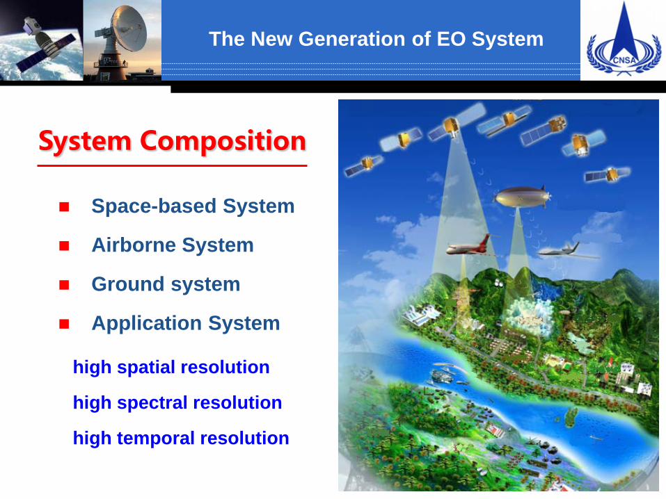
System Composition
Space-based System
Airborne System
Ground system
Application System
high spatial resolution
high spectral resolution
high temporal resolution
The New Generation of EO System

Space-based system
Several satellites with various orbits and various spectrum ranging from visible to microwave;
Satellites launched by LM launch vehicles;
Spatial resolution greater than 1.2m; spectral resolution reaching nanometer level, and swath ranging from
10km to 100km, with attitude maneuvering capability.
The New Generation of EO System

Airborne system
Consist of air flight platform, airborne earth observation instrument and data processing system;
Develop three types of earth observation equipments,including Optical, LASERs and SAR;
Spatial resolution greater than 0.1m, and spectrum resolution better 1nm.
The New Generation of EO System

Ground system
Consist of three operational systems: data receiving, data processing, data management and task scheduling system; and three kinds of supporting infrastructure: data receiving, calibration and public platform;
Responsible for mission planning, data receiving and processing, data distribution and massive data management;
Available for data sharing and efficient operation.
The New Generation of EO System

Application system
Consist of applied technology center subsystem and typical application subsystem;
Responsible for transferring earth observation data into application information and knowledge, and providing application services;
Establish a comprehensive application and service system with multi-source data to meet the domestic and international users’ requirements.
The New Generation of EO System
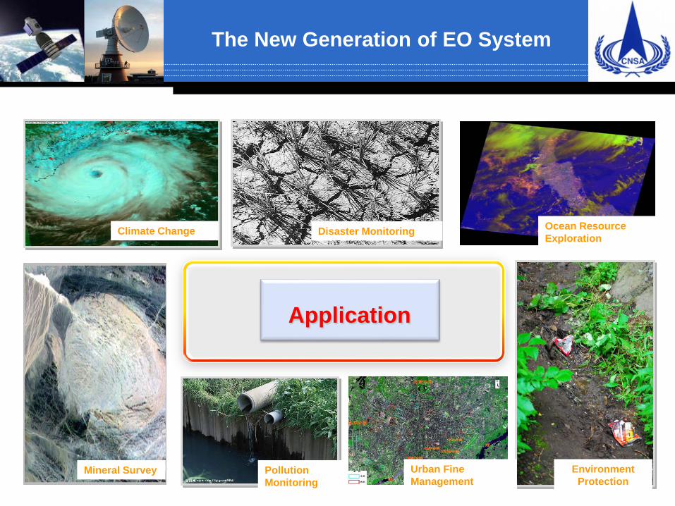
Application
Climate Change Disaster Monitoring Ocean Resource Exploration
Mineral Survey Pollution Monitoring
Environment Protection
Urban Fine Management
The New Generation of EO System

Data Grid for Public Service

The data center is organized into a coalition including 6 key members and over 30 national ministries or state bureaus.
Centre for Major National Project, State Administration of Science, Technology and Industry for National Defense
China Centre for Resources Satellite Data and Application Centre for Earth Observation and Digital Earth of Chinese Academy of Sciences National Satellite Meteorological Center National Satellite Center for Marine Applications
Data Grid for Public Service
The Earth Observation System and Data Center, CNSA
Forestry Statistics Agriculture
Water Resourc
es Transpor
tation Housing Land
Resources
Education
Topography
Environmental
Protection
Disaster Mitigatio
n

To build the national spatial data infrastructure to promote data sharing and reuse across multiple institutes and domains
To facilitate public data service and data integration.
To coordinate fast data transfer and production for emergency response.
Data Grid for Public Service
Goals of Data Grid for Public Service
5+x
基础设施即服务 平台即服务 数据即服务
PaaS DaaS
IaaS
软件即服务 SaaS
VPN-based Management Network Layer
Y=50
Internet-based Public Cloud Service Layer
林业
水利
住建
民政
……..
交通 北京
长三角
珠三角
……..
Z=1000
国土
减灾
管控节点
接收节点
处理节点 测控节点
Internal Data Network Layer
应用技术中心节点 环保 农
业 测绘
海洋
气象
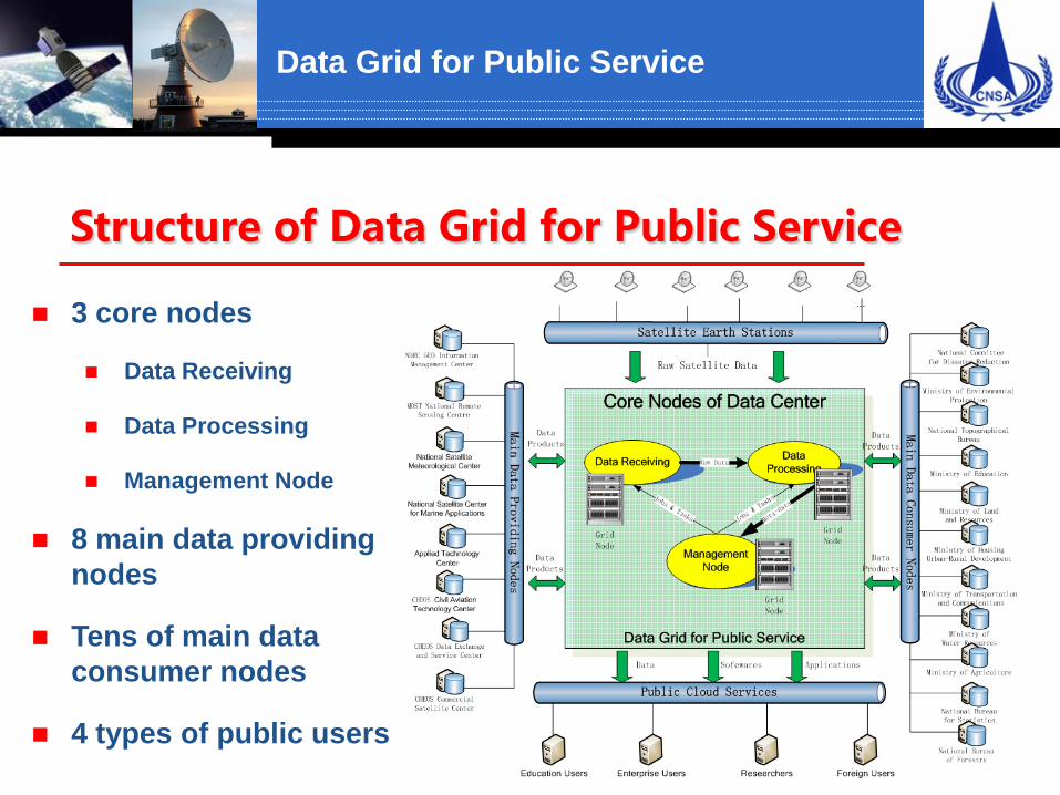
3 core nodes
Data Receiving
Data Processing
Management Node
8 main data providing nodes
Tens of main data consumer nodes
4 types of public users
Data Grid for Public Service
Structure of Data Grid for Public Service

Data Grid for Public Service
Application in Disaster Mitigation(1/2) The Data Grid could enables
Rapid utilization of disaster data stemming from a number of geographically distributed data sources.
Fast disaster information collection, disaster data mitigation, and disaster application delivering.
On demand and integrated services for emergency decision,
Quality control of key process to address the monitoring and early warning.
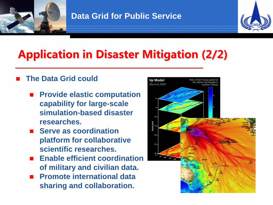
The Data Grid could
Provide elastic computation capability for large-scale simulation-based disaster researches.
Serve as coordination platform for collaborative scientific researches.
Enable efficient coordination of military and civilian data.
Promote international data sharing and collaboration.
Data Grid for Public Service
Application in Disaster Mitigation (2/2)

International Cooperation
Principles of International Cooperation
The international cooperation in China’s new generation Earth Observation System complies with the principles as described in the white paper of China's Space Activities in 2011. The following are given priority to:
Reinforcing space cooperation with the developing countries, and veluing space cooperation with the developed countries
Carrying out multi-level and multi-form international cooperation Conducting commercial cooperation actively and pragmatically
International Cooperation

International Cooperation
UN-SPIDER CHARTER GEO
Multilateral Cooperation:
ESA, Russia, Brazil, Thailand, South Africa, etc.
Bilateral Cooperation:
International Cooperation

International Cooperation
Earth Observation System & Data Center of CNSA is willing to cooperate with the governments and space agencies all over the world on the basis of principle of peaceful utilization of outer space, and actively participate in the international space cooperation, and try our best to promote the development of space industry, thus contribute more to the scientific and technical progress and the lofty cause of human peace and development.
International Cooperation

24
Thanks for your attention !