Cities Safer by Design: Designing Safer Streets and Communities - Transforming Transportation 2016

Designing Streets for Transit
Introducing the NACTO Transit Street Design Guide
Craig ToocheckProgram Analyst/Designer,Designing Cities Initiative
National Association of City Transportation Officials

Urban Street Design GuidePublished Fall 2013
Urban Bikeway Design GuidePublished Spring 20112nd Edition Fall 2012
Transit Street Design GuidePublished April 2016
NACTO Design Guides

Why Transit Streets Matter
Better Streets, Better Service
Transit Creates Urban Places
A Mobility Service For The Whole
City
Growth Without Congestion
Safe Movement At A Large Scale
Permanent Economic Benefits

Better Streets, Better Service

Better Streets, Better Service

Better Streets, Better Service

15% runtime savings 1st and 2nd Avenues, New York City Source: NYC DOT
Better Streets, Better Service

Better Streets, Better Service
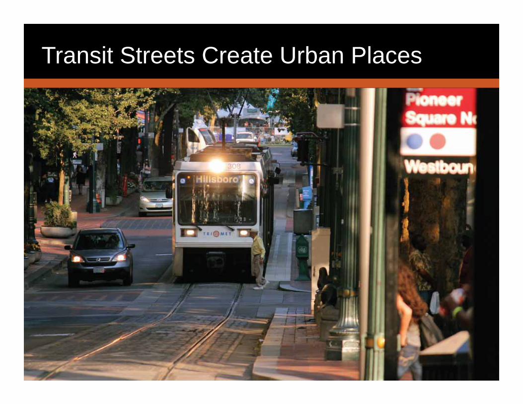
Transit Streets Create Urban Places

Growth Without Congestion

Permanent Economic Benefits

Safe Movement at a Large Scale

Mobility for the Whole City

Transit Streets

TransitStreetContext
Neighborhood
Corridor
Downtown

Neighborhood Transit Street example
In-lane stops keep buses in priority position. Near-side avoids intersection queueing. Can alternate with far-side, pull-out.
Loading zones relieve double parking, provide business access.
Bulbs create space for shelters, reduce crossing distance.
Short signal cycles reduce wait time when bus falls behind progression.
Transit Streets

Textured pavement or vertical separation keep traffic out of transitway
Platforms can be consolidated or separate to fit on narrow ROW
Downtown Transit Street example
Platform-platform crossing serves ped desires lines
Transit Streets

Transit Lanes
Offset Transit Lane • Maintains curbside space for other treatments
• Relatively simple & low-cost• Lacks separation

Stops & Stations
In-Lane Stops • Speeds service by eliminating pull-in and pull-out maneuvers

Stops & Stations
Side-Boarding Islands
• Enables in-lane stops• Balances safe bike and transit
movements• Generally does not require
drainage modifications

Stops & Stations
Shelters
• Place with appropriate clear paths
• Typically 4’ deep (2’ in constrained conditions)
• May face or back up against the road bed
• Enhances comfort and place
Stops & Stations
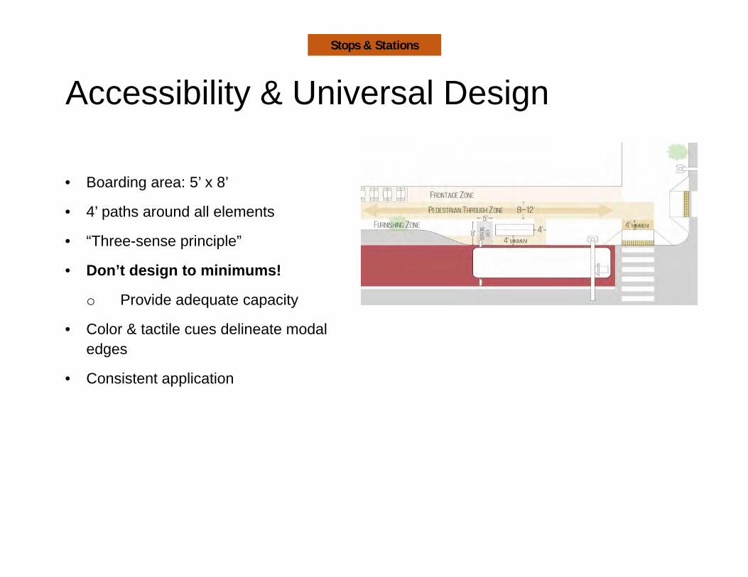
Accessibility & Universal Design
• Boarding area: 5’ x 8’
• 4’ paths around all elements
• “Three-sense principle”
• Don’t design to minimums!
o Provide adequate capacity
• Color & tactile cues delineate modal edges
• Consistent application
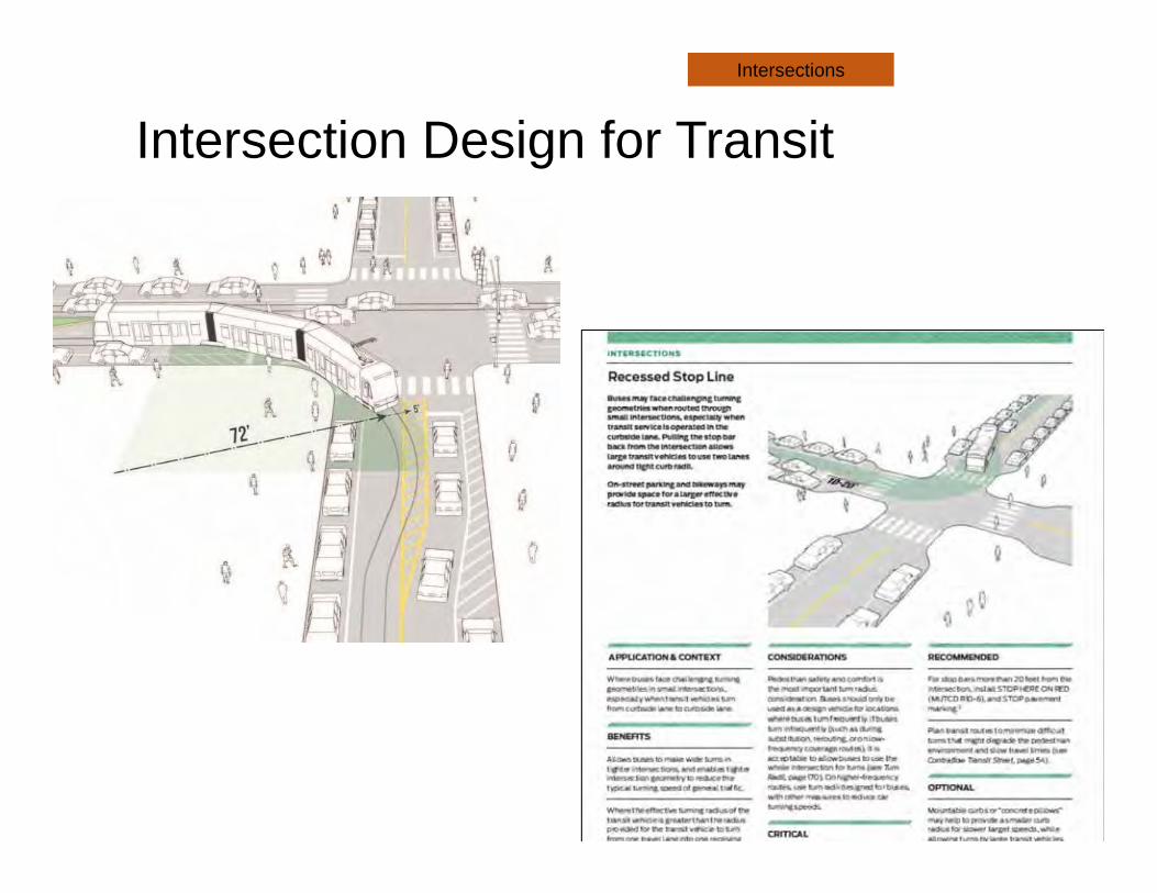
Intersection Design for TransitIntersections

Minimize Person Delay:Turn restrictions
Intersections

System design: HoustonSystem Strategies

System design: Houston System Strategies

Route modificationsSystem Strategies
- Steering Committee- 40 cities & 18 transit agencies
- ITE - Complete Streets Council review
- APTA - Sustainable Urban Design Standards
- Independent Technical review
Creating the Guide
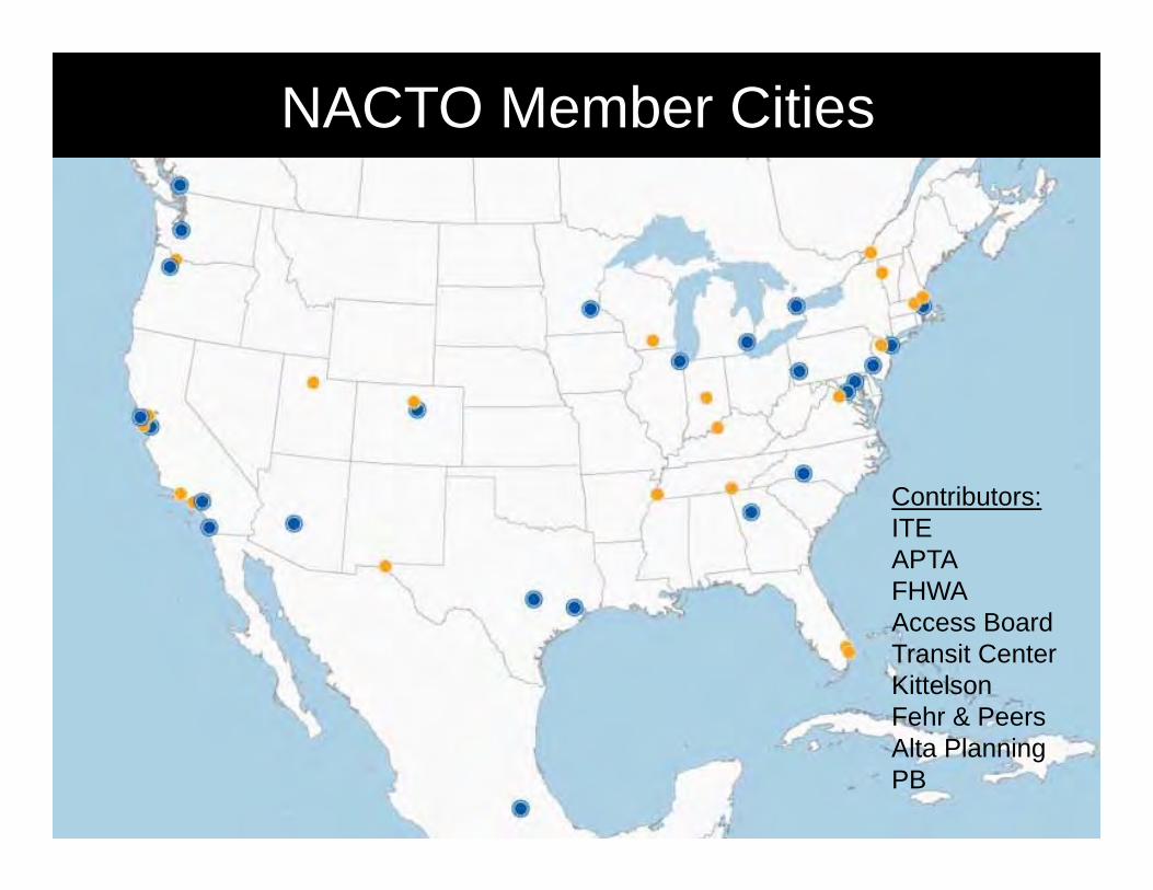
NACTO Member Cities
Contributors:ITEAPTAFHWAAccess BoardTransit CenterKittelsonFehr & PeersAlta PlanningPB

• Officially released April 15• Launch event at NYC Transit Museum: April 26• Webinar hosted by Island Press: April 27
More details at nacto.org/events
Release Events

Transit Street Design Guide
Order today atIslandpress.org
20% off with code 2NACTO
Craig Toocheck

NACTO & ITE Partnership:From Design Guide to Implementation / Operation
Lawrence MarcusBureau Chief, Transportation Engineering & OperationsArlington County, VA
ITE Transportation Planning Council ChairITE Complete Streets Council
32

Arlington County Multi‐modal CultureTransportation Facilities & Services – Expanding Travel Options
33
• 1,100 lane‐miles• 19 miles of HOV lanes• 12 miles of Metrorail lines and 11 stations• VRE commuter rail• Extensive regional and local bus • Expanding car‐share program with over 80 cars
• 80+ Capital Bikeshare stations• 50 miles of multi‐use trails• 36 miles of on‐street bike facilities

34
Crystal City Potomac Yard TransitwayImplementation Case Study

Crystal City Vicinity
Pentagon
Washington National Airport
Arlington National Cemetery

36
Crystal City – Location & History

Crystal City Sector Plan ‐ Transportation
37
Sector Plan calls for phased development of Street Network

Crystal City Potomac Yard Transitway
38

39
What is the project?• Joint project between Arlington County and
City of Alexandria
• Transit improvements on 4.5‐mile corridor between Pentagon City and Braddock Road Metrorail stations
• First surface transitway of its kind in the Washington region
• Dedicated lanes & exclusive right‐of‐way
• 30 station platforms along corridor
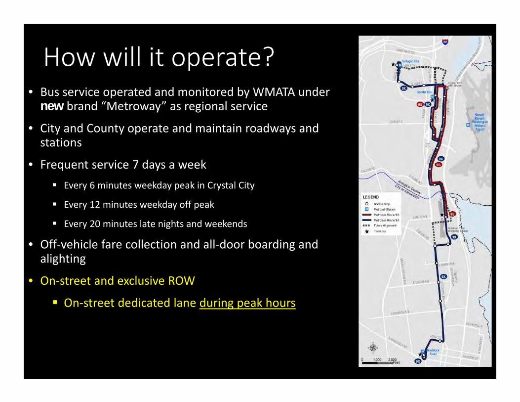
How will it operate?• Bus service operated and monitored by WMATA under
new brand “Metroway” as regional service
• City and County operate and maintain roadways and stations
• Frequent service 7 days a week Every 6 minutes weekday peak in Crystal City
Every 12 minutes weekday off peak
Every 20 minutes late nights and weekends
• Off‐vehicle fare collection and all‐door boarding and alighting
• On‐street and exclusive ROW
On‐street dedicated lane during peak hours
40

How will the network operate from a complete streets perspective?
41

With a dedicated lane during the peak periods, what are the challenges to design and operate the street?
ITE can help!
42

Complete Streets Challenges1. Multi‐jurisdiction Transit Signal Priority2. Cross‐section Design3. Safety: Potential Conflict Points
43

Transitway Operational Challenges
1. Traffic signal operations2. Transit signal priority
• Coordination with WMATA
• Coordination between two jurisdictions
• Technology
3. Right turns vs. transit ops. on exclusive ROW
44

Design & Curbside Management
1. Urban environment / limited ROW2. Cross‐section alternatives
• bike accommodation options• Location of bike lane
3. Curbside management
45

Option 1
Option 2

Questions: [email protected]
NACTO’s Transit Street Design Guide• Key points:
• Purpose of doc (MR) 5 min• Doc development process (MR) 1 min• Release activities (MR) 1 min• ITE role / follow‐up docs (LM) 1 min• Arlington example (LM) 2 min• ITE related challenges (LM) 7 min• Closeout 1 min