Derek L. Doughty, P.E. October 15, 2013 Chair Honorable ...
44
Derek L. Doughty, P.E. Chair Mitch Thrower Vice Chair Bowen A. Arnold Member-at-Large Stephanie A. Agliano Stephen L. Benson, AICP Theodore Trent Green, R.A. Brian P. Hollands Gary Pike Jacqueline S. Wilds Ray Young Christina Hummel (Ex-Officio) MacDill AFB Cathy Valdes (Ex-Officio) School District Ramond A. Chiaramonte, AICP Executive Director 601 E. Kennedy, 18 th Floor P.O. Box 1110 Tampa, Florida 33601-1110 813/272-5940 Fax 813/272-6258 Fax 813/272-6255 www.planhillsborough.org October 15, 2013 Honorable Charlie Miranda, Chairman, and Members of City Council 315 East Kennedy Boulevard Tampa, Florida 33602 RE: Small Scale Amendment to the Tampa Comprehensive Plan TA/CPA 13-03, vicinity of 3705 West Carmen Street Adoption Public Hearings October 24, 2013 at 5:30 PM and November 7, 2013 at 10:30 AM On October 14, 2013, the Planning Commission held a public hearing, which had been continued from September 9, 2013. A finding of CONSISTENCY was made on a privately petitioned amendment to the Tampa Comprehensive Plan. Plan Amendment TA/CPA 13-03 is a request to amend the Future Land Use Plan Map from Residential-20 to Community Commercial-35 on approximately .58 acres of land in the Oakwood Park neighborhood. The amendment area is located east of Dale Mabry Highway and north of Kennedy Boulevard in the vicinity of West Carmen Street (3705 West Carmen Street) and North Sterling Avenue. This small-scale amendment to the Tampa Comprehensive Plan is scheduled for public hearings and consideration of adoption on Thursday, October 24, 2013 at 5:30 p.m. and Thursday, November 7, 2013 at 10:30 a.m. The Planning Commission adopted resolution, staff report and affidavits of public hearing notice are attached for your review in advance of the hearings. Sincerely, Ramond A. Chiaramonte, AICP, Executive Director RAC/rmp Attachments cc: Shirley Foxx-Knowles, City Clerk Julia Mandell, City Attorney Martin Shelby, City Council Attorney Randy Goers, City Planning Coordinator A consolidated city-county agency serving the cities of Tampa, Temple Terrace, Plant City and the County of Hillsborough. An Affirmative Action-Equal Opportunity Employer
Transcript of Derek L. Doughty, P.E. October 15, 2013 Chair Honorable ...
Derek L. Doughty, P.E. Chair
Mitch Thrower
Vice Chair
Bowen A. Arnold Member-at-Large
Stephanie A. Agliano
Stephen L. Benson, AICP Theodore Trent Green, R.A.
Brian P. Hollands Gary Pike
Jacqueline S. Wilds Ray Young
Christina Hummel (Ex-Officio) MacDill AFB
Cathy Valdes (Ex-Officio)
School District
Ramond A. Chiaramonte, AICP Executive Director
601 E. Kennedy, 18th Floor P.O. Box 1110
Tampa, Florida 33601-1110 813/272-5940
Fax 813/272-6258 Fax 813/272-6255
www.planhillsborough.org
October 15, 2013
Honorable Charlie Miranda, Chairman, and Members of City Council 315 East Kennedy Boulevard Tampa, Florida 33602
RE: Small Scale Amendment to the Tampa Comprehensive Plan TA/CPA 13-03, vicinity of 3705 West Carmen Street Adoption Public Hearings
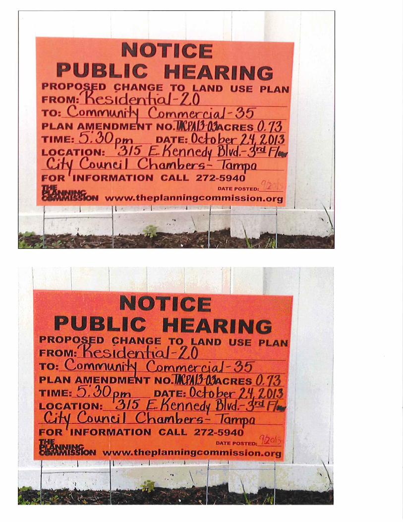
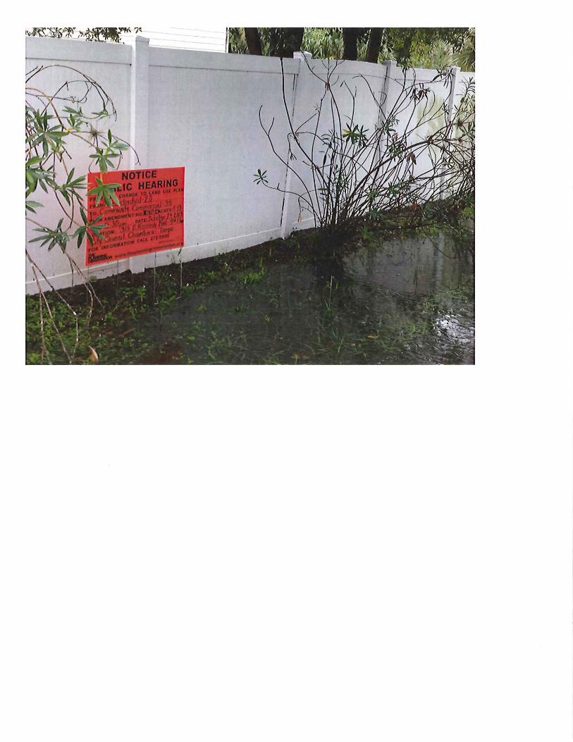
October 24, 2013 at 5:30 PM and November 7, 2013 at 10:30 AM On October 14, 2013, the Planning Commission held a public hearing, which had been continued from September 9, 2013. A finding of CONSISTENCY was made on a privately petitioned amendment to the Tampa Comprehensive Plan. Plan Amendment TA/CPA 13-03 is a request to amend the Future Land Use Plan Map from Residential-20 to Community Commercial-35 on approximately .58 acres of land in the Oakwood Park neighborhood. The amendment area is located east of Dale Mabry Highway and north of Kennedy Boulevard in the vicinity of West Carmen Street (3705 West Carmen Street) and North Sterling Avenue. This small-scale amendment to the Tampa Comprehensive Plan is scheduled for public hearings and consideration of adoption on Thursday, October 24, 2013 at 5:30 p.m. and Thursday, November 7, 2013 at 10:30 a.m. The Planning Commission adopted resolution, staff report and affidavits of public hearing notice are attached for your review in advance of the hearings. Sincerely,
Ramond A. Chiaramonte, AICP, Executive Director RAC/rmp Attachments
cc: Shirley Foxx-Knowles, City Clerk Julia Mandell, City Attorney Martin Shelby, City Council Attorney Randy Goers, City Planning Coordinator
A consolidated city-county agency serving the cities of Tampa, Temple Terrace, Plant City and the County of Hillsborough. An Affirmative Action-Equal Opportunity Employer
EXECUTIVE SUMMARY Meeting Date: October 14, 2013 Public Hearing Agenda Item: Tampa: Comprehensive Plan Amendment TA/CPA 13-03 Presenter: Tony LaColla, AICP (extension 350) Action Necessary: Yes
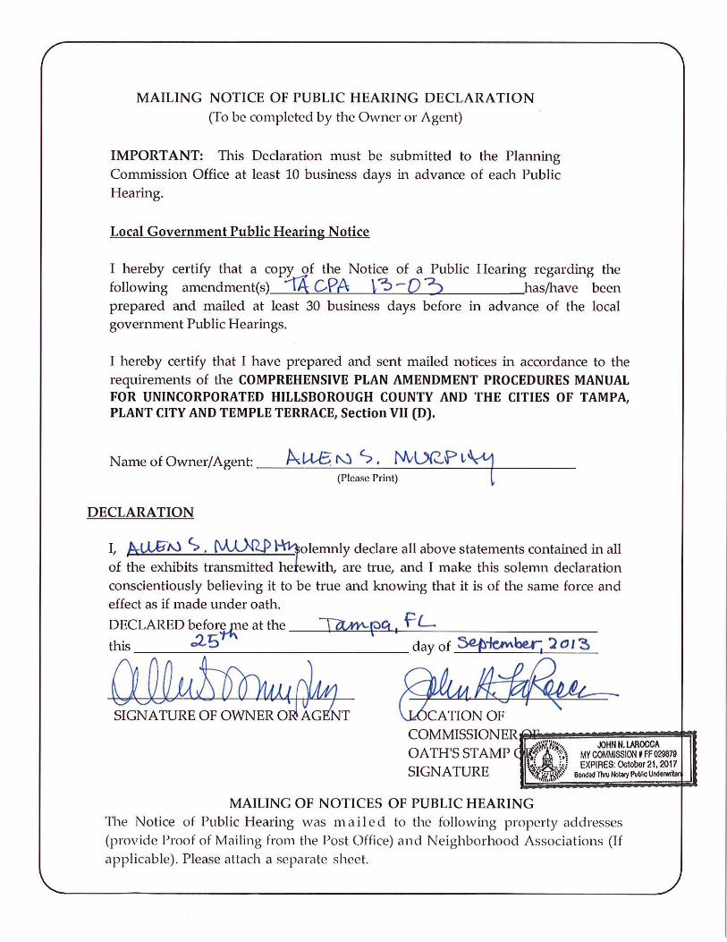
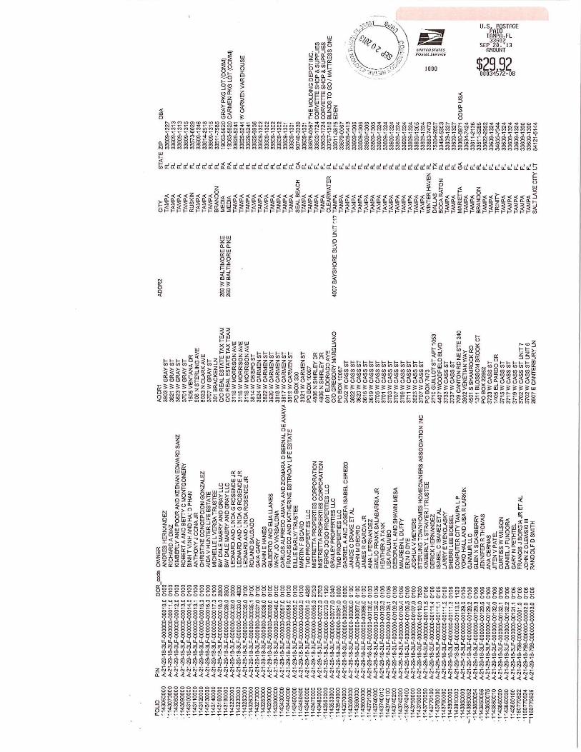
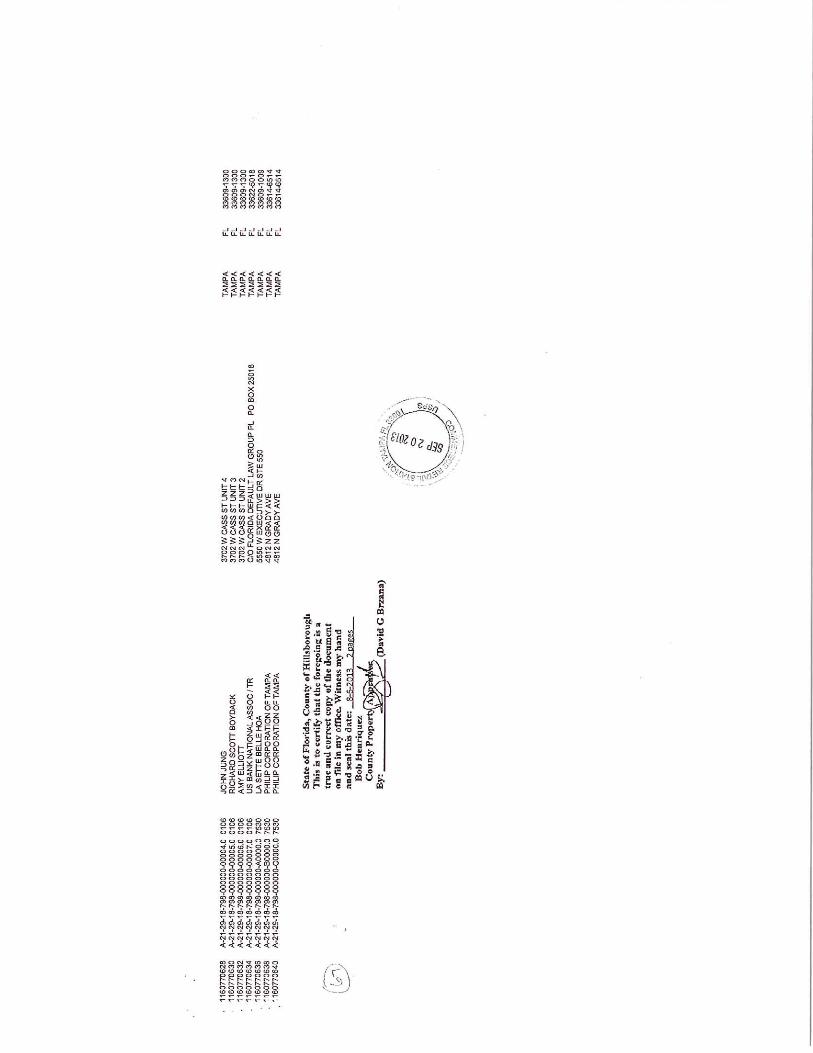
SUMMARY: The Tampa Comprehensive Plan is the official document guiding the long-term development of the City of Tampa. The Planning Commission is required to make recommendations to the Tampa City Council on all proposed changes to the Tampa Comprehensive Plan pursuant to Chapter 163, Part II, Florida Statutes and Chapter 97-351, Laws of Florida, as amended. Plan Amendment TA/CPA 13-03 is a privately-initiated request to amend the Tampa Comprehensive Plan Future Land Use Plan Map which meets criteria for being reviewed as a small-scale amendment. The site is comprised of one parcel containing four platted lots, totaling approximately .58 acres in size, located at 3705 West Carmen in the Westshore Planning District between Interstate-275 and Kennedy Boulevard. The request is to amend the Future Land Use Map designation from Residential-20 to Community Commercial-35. The effect of the map amendment, if approved, will recognize an existing land use that has been in place on the subject site since prior to 1962 and allow continued operation of the existing business. RECOMMENDATION: It is recommended that the Planning Commission APPROVE the attached resolution finding the amendment TA/CPA 13-03 CONSISTENT with the Tampa Comprehensive Plan and forward this recommendation to the Tampa City Council for consideration of adoption of the amendment. ATTACHMENTS: Resolution and Staff Report
Hillsborough County City-County Planning Commission 601 E Kennedy Blvd., 18th floor, Tampa, Florida, 33601 ·813-272-5940·theplanningcommission.org
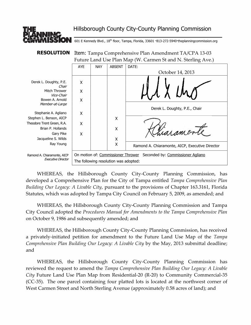
RESOLUTION Item: Tampa Comprehensive Plan Amendment TA/CPA 13-03
Future Land Use Plan Map (W. Carmen St and N. Sterling Ave.)
AYE NAY ABSENT DATE:
October 14, 2013
Derek L. Doughty, P.E. X Chair
Mitch Thrower X Vice-Chair
Bowen A. Arnold X Member-at-Large
Derek L. Doughty, P.E., Chair
Stephanie A. Agliano X Stephen L. Benson, AICP X
Theodore Trent Green, R.A. X Brian P. Hollands X
Gary Pike X Jacqueline S. Wilds X
Ray Young X Ramond A. Chiaramonte, AICP, Executive Director
Ramond A. Chiaramonte, AICP Executive Director
On motion of: Commissioner Thrower Seconded by: Commissioner Agliano
The following resolution was adopted:
WHEREAS, the Hillsborough County City-County Planning Commission, has
developed a Comprehensive Plan for the City of Tampa entitled Tampa Comprehensive Plan
Building Our Legacy: A Livable City, pursuant to the provisions of Chapter 163.3161, Florida
Statutes, which was adopted by Tampa City Council on February 5, 2009, as amended; and
WHEREAS, the Hillsborough County City-County Planning Commission and Tampa
City Council adopted the Procedures Manual for Amendments to the Tampa Comprehensive Plan
on October 9, 1986 and subsequently amended; and
WHEREAS, the Hillsborough County City-County Planning Commission, has received
a privately-initiated petition for amendment to the Future Land Use Map of the Tampa
Comprehensive Plan Building Our Legacy: A Livable City by the May, 2013 submittal deadline;
and
WHEREAS, the Hillsborough County City-County Planning Commission has
reviewed the request to amend the Tampa Comprehensive Plan Building Our Legacy: A Livable
City Future Land Use Plan Map from Residential-20 (R-20) to Community Commercial-35
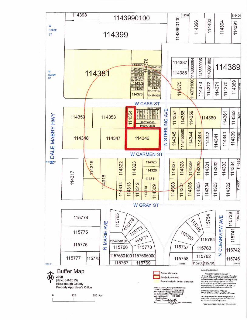
(CC-35). The one parcel containing four platted lots is located at the northwest corner of
West Carmen Street and North Sterling Avenue (approximately 0.58 acres of land); and
Hillsborough County City-County Planning Commission 601 E Kennedy Blvd., 18th floor, Tampa, Florida, 33601 ·813-272-5940·theplanningcommission.org
RESOLUTION PAGE 2 Title: Tampa Comprehensive Plan TA/CPA 13-03 Future Land Use Plan Map Date of Hearing: October 14, 2013
WHEREAS, the Hillsborough County City-County Planning Commission has reviewed the proposal, has considered existing and expected future development patterns and community facilities in the respective area, as well as the adopted goals, objectives and policies of the Tampa Comprehensive Plan Building Our Legacy: A Livable City as follows:
Sensitive Transition Policy 1.2.2: The City shall preserve, protect, and enhance single family neighborhoods by providing sensitive transitions between these neighborhoods and adjoining areas, and requiring new development, both private and public, to respect and respond to those existing physical characteristics— buildings, streetscapes, open spaces, and city form—that contribute to the overall character and livability of the neighborhood. Livable City Economic Prosperity Objective 12.1: A positive business climate supported by adequate public infrastructure, including transportation and schools. Business Centers Objective 14.2: Ensure the continued prosperity and competitiveness of the city’s premier business centers. Policy 14.2.1: Partnership - The City shall maintain regular and ongoing coordination efforts with the Tampa Downtown Partnership, the Westshore Alliance and the University of South Florida to ensure that key city building decisions support these economic centers. Mixed-Use Corridors Objective 16.1: The transformation of major corridors to include a broader mix of uses, both horizontal and vertical, that provides opportunities for medium and higher density housing, while also addressing local and citywide demand for retail and services. Policy 16.1.1: Redeveloping Automobile-oriented Corridors - The City shall promote redevelopment of existing automobile-oriented corridors and the upgrading of existing commercial development to create vibrant, mixed-use boulevards that balance efficient movement of motor vehicles with the creation of attractive pedestrian-friendly districts that serve the adjoining neighborhoods as well as passing motorists.
RESOLUTION PAGE 3 Title: Tampa Comprehensive Plan TA/CPA 13-03 Future Land Use Plan Map Date of Hearing: October 14, 2013
Policy 16.1.7: Differentiation of the Corridors - The long-term development direction is to create linear mixed use villages in these corridors. Three types of mixed use corridor villages are defined and they are based on the scale of the development pattern to be expected – suburban mixed use scale corridor village (refer to the SMU-6 plan category for more detail); community mixed use scale corridor village (refer to the CMU-35 and CC-35 plan categories for more detail); and the urban mixed use scale corridor village (refer to the UMU-60 plan category for more detail). Neighborhoods Policy 18.1.1: Recognize that every neighborhood has assets that identify that neighborhood and contribute to the well-being of the people who live there. Understand what those are and look for opportunities to enhance them and leverage them for neighborhood improvement. Assets include trees, large yards, schools, people and independent businesses. Commercial Areas Policy 18.6.5: Require commercial uses to be appropriately buffered from any residential development.
WHEREAS, the Hillsborough County City-County Planning Commission recognizes that the petitioned amendment continues the policy direction of the Tampa City Council to remove industrial lands and uses to encourage residential and other compatible uses in accordance with the planning direction of the South Tampa Planning District;
NOW, THEREFORE, BE IT RESOLVED, that the Hillsborough County City-County
Planning Commission finds Tampa Comprehensive Plan Amendment TA/CPA 13-03 CONSISTENT with the Tampa Comprehensive Plan Building Our Legacy: A Livable City and recommends the plan amendment be approved.
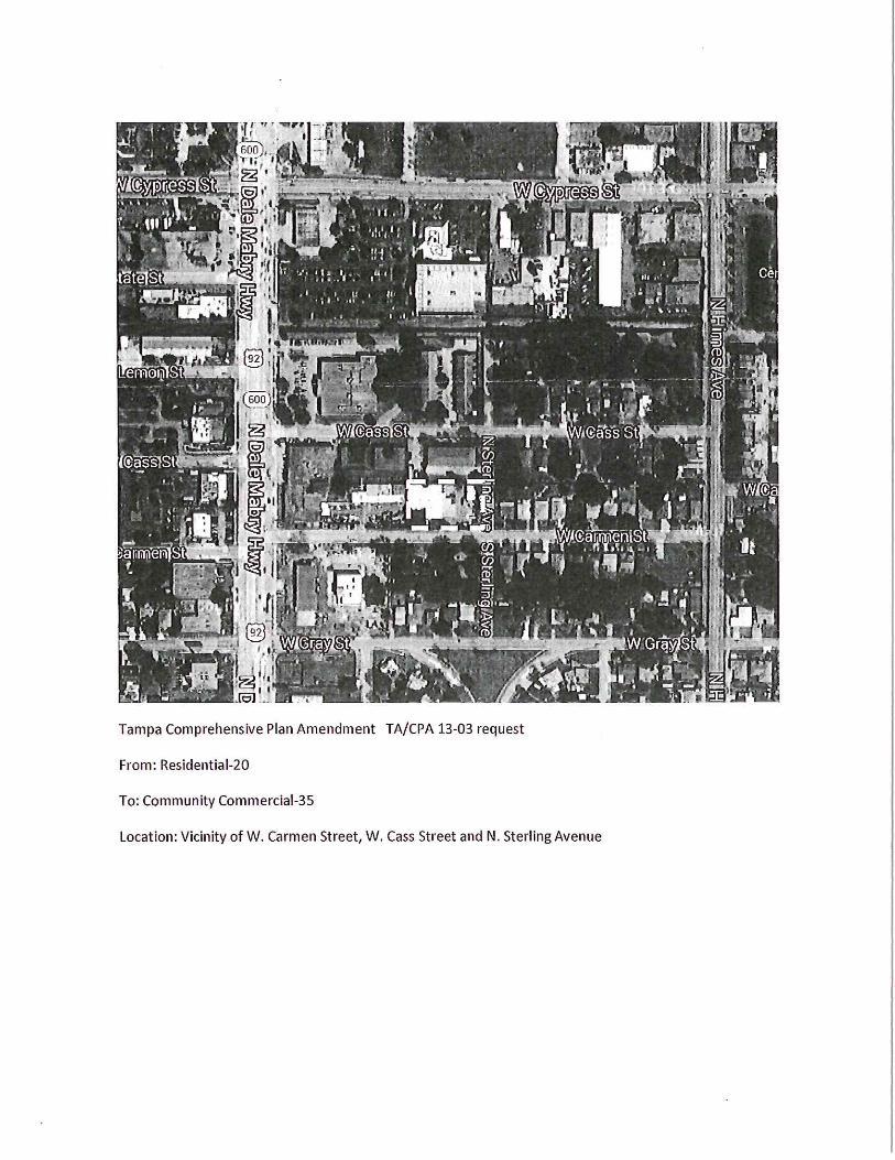
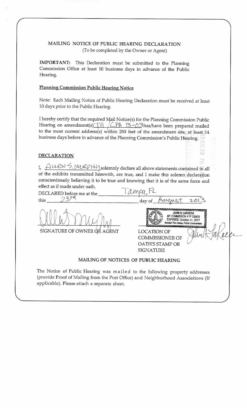
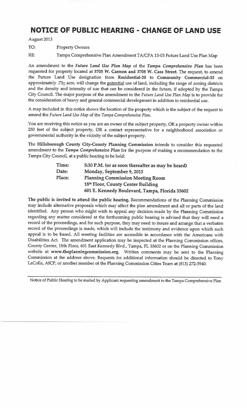
W. Carmen Street and N. Sterling Ave. Page 1 of 16 TA/CPA 13-03 Small Scale Future Land Use Map Plan Amendment
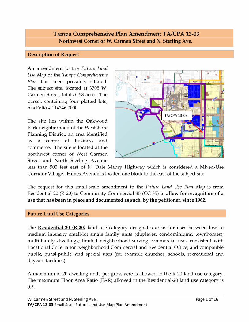
Tampa Comprehensive Plan Amendment TA/CPA 13-03 Northwest Corner of W. Carmen Street and N. Sterling Ave.
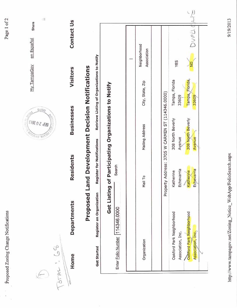
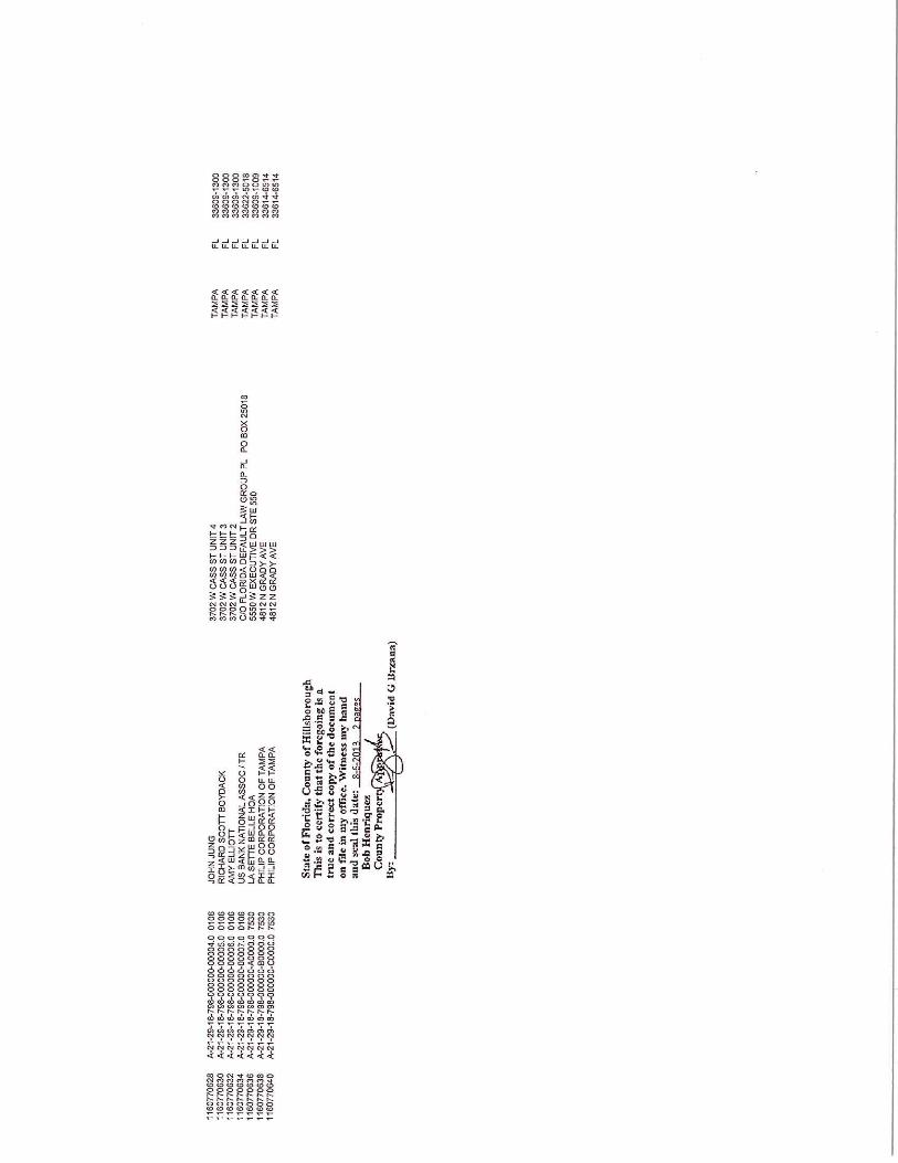
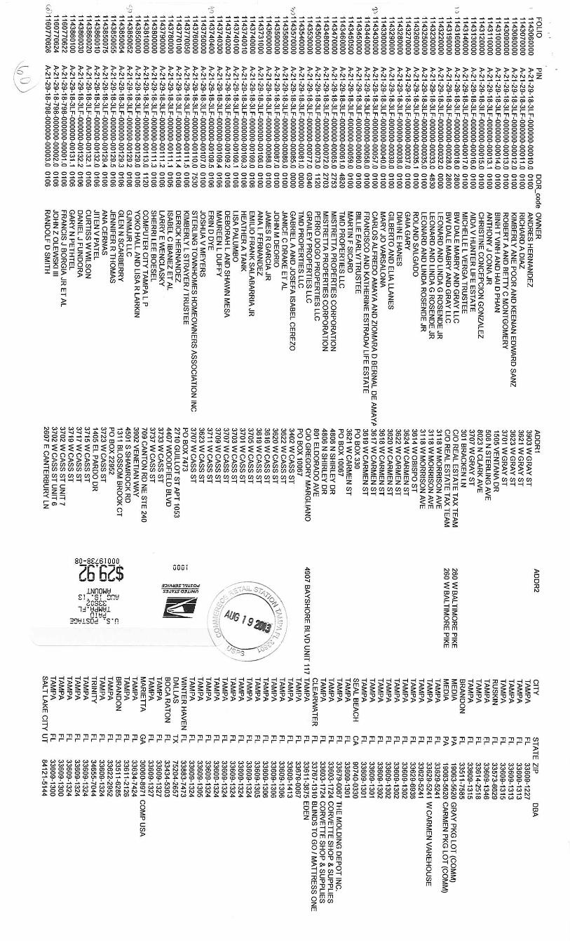
Description of Request An amendment to the Future Land Use Map of the Tampa Comprehensive Plan has been privately-initiated. The subject site, located at 3705 W. Carmen Street, totals 0.58 acres. The parcel, containing four platted lots, has Folio # 114346.0000. The site lies within the Oakwood Park neighborhood of the Westshore Planning District, an area identified as a center of business and commerce. The site is located at the northwest corner of West Carmen Street and North Sterling Avenue less than 500 feet east of N. Dale Mabry Highway which is considered a Mixed-Use Corridor Village. Himes Avenue is located one block to the east of the subject site. The request for this small-scale amendment to the Future Land Use Plan Map is from Residential-20 (R-20) to Community Commercial-35 (CC-35) to allow for recognition of a use that has been in place and documented as such, by the petitioner, since 1962. Future Land Use Categories The Residential-20 (R-20) land use category designates areas for uses between low to medium intensity small-lot single family units (duplexes, condominiums, townhomes); multi-family dwellings; limited neighborhood-serving commercial uses consistent with Locational Criteria for Neighborhood Commercial and Residential Office; and compatible public, quasi-public, and special uses (for example churches, schools, recreational and daycare facilities). A maximum of 20 dwelling units per gross acre is allowed in the R-20 land use category. The maximum Floor Area Ratio (FAR) allowed in the Residential-20 land use category is 0.5.
TA/CPA 13-03
W. Carmen Street and N. Sterling Ave. Page 2 of 16 TA/CPA 13-03 Small Scale Future Land Use Map Plan Amendment
The Community Commercial-35 (CC-35) land use category provides for horizontal and vertical mixed-use development and single-use commercial and residential development that includes: intensive and general commercial, service, office, and residential uses. Gathering places such as a plaza, courtyard, or park and compatible public, quasi-public, and special uses are also permitted. The development pattern includes a mix of non-residential and residential uses with more intense development near major intersections. A maximum of 35 dwelling units per gross acre is allowed in the CC-35 land use category. The maximum Floor Area Ratio (FAR) allowed in the CC-35 land use category is 2.0.
Potential Build-Out based on Future Land Use Plan Category Designations* Existing potential under R-20:
11 Dwelling Units 12,577 sq. ft. of commercial or office use
Potential if CC-35 is Approved:
20 Dwelling Units 50,308 sq. ft. of Commercial or office use
*Potential maximum build-out is for all lands included in the amendment and does not take into account site specific conditions.
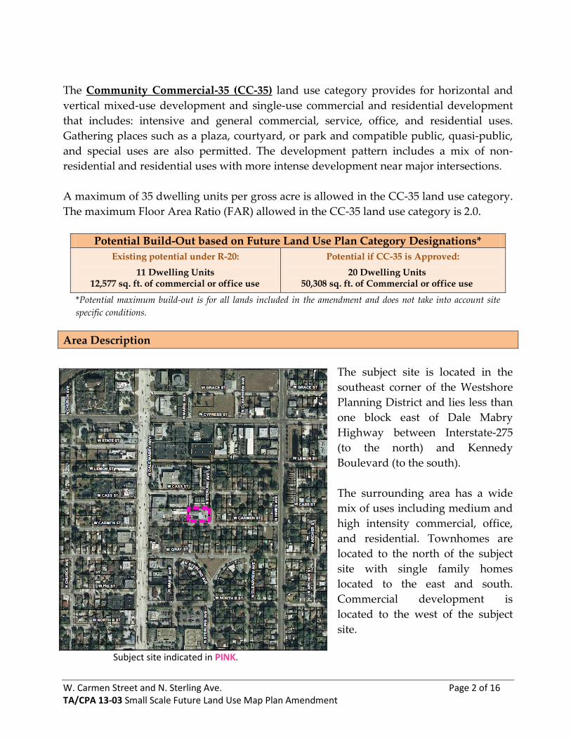
Area Description
The subject site is located in the southeast corner of the Westshore Planning District and lies less than one block east of Dale Mabry Highway between Interstate-275 (to the north) and Kennedy Boulevard (to the south). The surrounding area has a wide mix of uses including medium and high intensity commercial, office, and residential. Townhomes are located to the north of the subject site with single family homes located to the east and south. Commercial development is located to the west of the subject site. Subject site indicated in PINK.
W. Carmen Street and N. Sterling Ave. Page 3 of 16 TA/CPA 13-03 Small Scale Future Land Use Map Plan Amendment
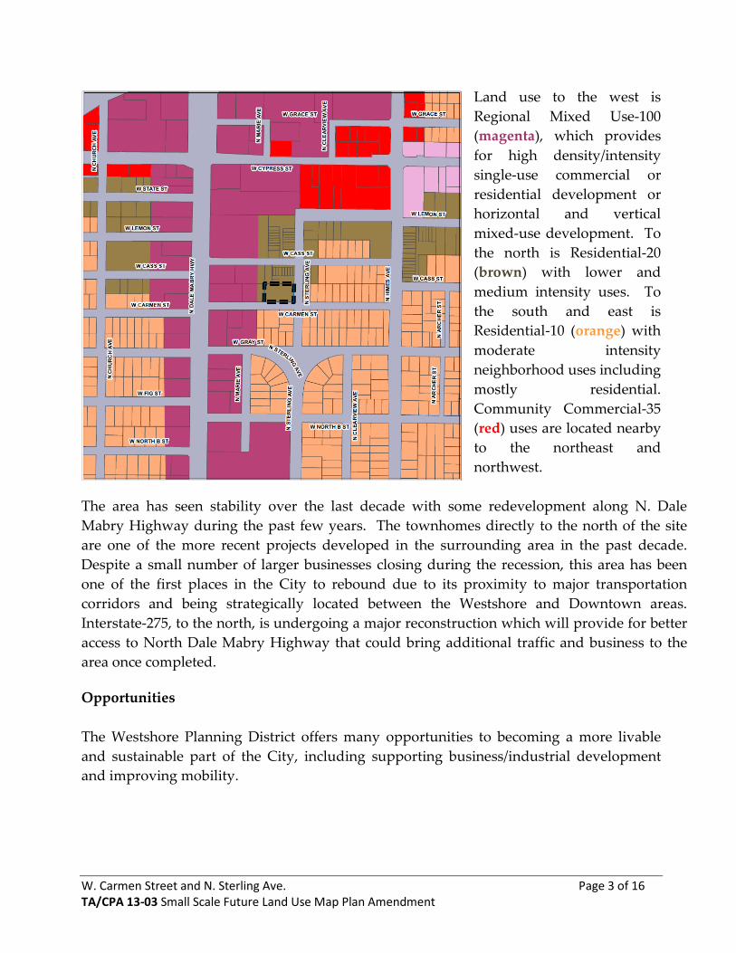
Land use to the west is Regional Mixed Use-100 (magenta), which provides for high density/intensity single-use commercial or residential development or horizontal and vertical mixed-use development. To the north is Residential-20 (brown) with lower and medium intensity uses. To the south and east is Residential-10 (orange) with moderate intensity neighborhood uses including mostly residential. Community Commercial-35 (red) uses are located nearby to the northeast and northwest.
The area has seen stability over the last decade with some redevelopment along N. Dale Mabry Highway during the past few years. The townhomes directly to the north of the site are one of the more recent projects developed in the surrounding area in the past decade. Despite a small number of larger businesses closing during the recession, this area has been one of the first places in the City to rebound due to its proximity to major transportation corridors and being strategically located between the Westshore and Downtown areas. Interstate-275, to the north, is undergoing a major reconstruction which will provide for better access to North Dale Mabry Highway that could bring additional traffic and business to the area once completed. Opportunities The Westshore Planning District offers many opportunities to becoming a more livable and sustainable part of the City, including supporting business/industrial development and improving mobility.
W. Carmen Street and N. Sterling Ave. Page 4 of 16 TA/CPA 13-03 Small Scale Future Land Use Map Plan Amendment
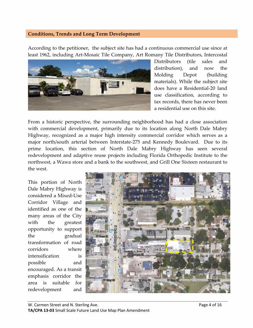
Conditions, Trends and Long Term Development According to the petitioner, the subject site has had a continuous commercial use since at least 1962, including Art-Mosaic Tile Company, Art Romany Tile Distributors, Intercostal
Distributors (tile sales and distribution), and now the Molding Depot (building materials). While the subject site does have a Residential-20 land use classification, according to tax records, there has never been a residential use on this site.
From a historic perspective, the surrounding neighborhood has had a close association with commercial development, primarily due to its location along North Dale Mabry Highway, recognized as a major high intensity commercial corridor which serves as a major north/south arterial between Interstate-275 and Kennedy Boulevard. Due to its prime location, this section of North Dale Mabry Highway has seen several redevelopment and adaptive reuse projects including Florida Orthopedic Institute to the northwest, a Wawa store and a bank to the southwest, and Grill One Sixteen restaurant to the west. This portion of North Dale Mabry Highway is considered a Mixed-Use Corridor Village and identified as one of the many areas of the City with the greatest opportunity to support the gradual transformation of road corridors where intensification is possible and encouraged. As a transit emphasis corridor the area is suitable for redevelopment and
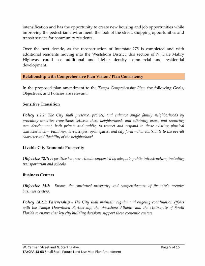
W. Carmen Street and N. Sterling Ave. Page 5 of 16 TA/CPA 13-03 Small Scale Future Land Use Map Plan Amendment
intensification and has the opportunity to create new housing and job opportunities while improving the pedestrian environment, the look of the street, shopping opportunities and transit service for community residents. Over the next decade, as the reconstruction of Interstate-275 is completed and with additional residents moving into the Westshore District, this section of N. Dale Mabry Highway could see additional and higher density commercial and residential development. Relationship with Comprehensive Plan Vision / Plan Consistency In the proposed plan amendment to the Tampa Comprehensive Plan, the following Goals, Objectives, and Policies are relevant: Sensitive Transition Policy 1.2.2: The City shall preserve, protect, and enhance single family neighborhoods by providing sensitive transitions between these neighborhoods and adjoining areas, and requiring new development, both private and public, to respect and respond to those existing physical characteristics— buildings, streetscapes, open spaces, and city form—that contribute to the overall character and livability of the neighborhood. Livable City Economic Prosperity Objective 12.1: A positive business climate supported by adequate public infrastructure, including transportation and schools. Business Centers Objective 14.2: Ensure the continued prosperity and competitiveness of the city’s premier business centers. Policy 14.2.1: Partnership - The City shall maintain regular and ongoing coordination efforts with the Tampa Downtown Partnership, the Westshore Alliance and the University of South Florida to ensure that key city building decisions support these economic centers.
W. Carmen Street and N. Sterling Ave. Page 6 of 16 TA/CPA 13-03 Small Scale Future Land Use Map Plan Amendment
Mixed-Use Corridors Objective 16.1: The transformation of major corridors to include a broader mix of uses, both horizontal and vertical, that provides opportunities for medium and higher density housing, while also addressing local and citywide demand for retail and services. Policy 16.1.1: Redeveloping Automobile-oriented Corridors - The City shall promote redevelopment of existing automobile-oriented corridors and the upgrading of existing commercial development to create vibrant, mixed-use boulevards that balance efficient movement of motor vehicles with the creation of attractive pedestrian-friendly districts that serve the adjoining neighborhoods as well as passing motorists. Policy 16.1.7: Differentiation of the Corridors - The long-term development direction is to create linear mixed use villages in these corridors. Three types of mixed use corridor villages are defined and they are based on the scale of the development pattern to be expected – suburban mixed use scale corridor village (refer to the SMU-6 plan category for more detail); community mixed use scale corridor village (refer to the CMU-35 and CC-35 plan categories for more detail); and the urban mixed use scale corridor village (refer to the UMU-60 plan category for more detail). Neighborhoods Policy 18.1.1: Recognize that every neighborhood has assets that identify that neighborhood and contribute to the well-being of the people who live there. Understand what those are and look for opportunities to enhance them and leverage them for neighborhood improvement. Assets include trees, large yards, schools, people and independent businesses. Commercial Areas Policy 18.6.5: Require commercial uses to be appropriately buffered from any residential development.
W. Carmen Street and N. Sterling Ave. Page 7 of 16 TA/CPA 13-03 Small Scale Future Land Use Map Plan Amendment
Staff Analysis and Conclusion
A number of agencies/departments were part of the review process and requested to submit feedback on the amendment. Some agencies did have comments included in Attachment A of this report. The reviewing agencies/departments included the following:
City of Tampa –Planning and Urban Design Division: Objections City of Tampa – Water Department: No Objections City of Tampa – Wastewater Department: No Objections City of Tampa – Stormwater Department: No Objections City of Tampa – Transportation Department: No Objections Hillsborough County Public Schools: No Objections The Environmental Protection Commission (EPC): No Objections Metropolitan Planning Organization (MPO): No Objections HART: No Objections The City of Tampa Planning and Urban Design Division is concerned that the CC-35 land use category would allow for intensive commercial uses on the property in the future which could potentially impact the residential areas to the north, east, and south of the subject site. Potential future redevelopment could be limited via the rezoning process, which the applicant will have to go through, by conditioning the site for limited uses as to provide a sensitive transition between the more intense RMU-100 immediately to the west and the low intensity R-20 and R-10 to the north, south, and east. The property owner will be subject to whatever development restrictions are ultimately determined by Tampa City Council during the rezoning process, based on staff recommendations and neighborhood concerns, should there be any. This is based on if the proposed plan amendment, as submitted, is adopted by Tampa City Council, which would be the first step of this process. The existing structure/business, directly abuts a business to the west that has a future land use designation of Regional Mixed Use-100, one of the most intense categories contained in the Comprehensive Plan. The present business on that site is an intensive commercial use, operating as such since 1985. Given the high intensity RMU-100 land use to the west, directly abutting the existing commercial site on Carmen Street, the surrounding residentially designated categories and the existing built environment, the proposed CC-35 designation for all four parcels on Carmen will allow for a reasonable transition in intensity into the residential area.
W. Carmen Street and N. Sterling Ave. Page 8 of 16 TA/CPA 13-03 Small Scale Future Land Use Map Plan Amendment
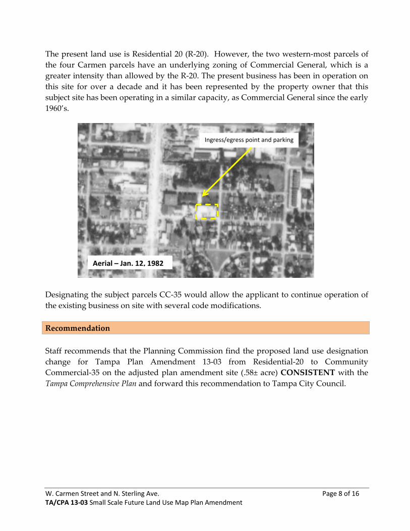
The present land use is Residential 20 (R-20). However, the two western-most parcels of the four Carmen parcels have an underlying zoning of Commercial General, which is a greater intensity than allowed by the R-20. The present business has been in operation on this site for over a decade and it has been represented by the property owner that this subject site has been operating in a similar capacity, as Commercial General since the early 1960’s.
Designating the subject parcels CC-35 would allow the applicant to continue operation of the existing business on site with several code modifications. Recommendation Staff recommends that the Planning Commission find the proposed land use designation change for Tampa Plan Amendment 13-03 from Residential-20 to Community Commercial-35 on the adjusted plan amendment site (.58± acre) CONSISTENT with the Tampa Comprehensive Plan and forward this recommendation to Tampa City Council.
Aerial – Jan. 12, 1982
Ingress/egress point and parking

W. Carmen Street and N. Sterling Ave. Page 9 of 16 TA/CPA 13-03 Small Scale Future Land Use Map Plan Amendment
Attachment A
Agency Comments City of Tampa Planning and Urban Design Division In the current city code a warehouse use is only allowed in the CI, IG and IH zoning categories. Provided the existing land uses surrounding this site, a land use designation of CC-35 will allow for intensive commercial uses on this property in the future. As part of this request, the parcel which fronts Cass Street has residential uses to the immediate north, west and east. This parcel has a land use category of R-20 which is consistent with the surrounding development and land use designations. The request for CC-35 would be inconsistent and allow for a much higher intensity of uses on this parcel which is surrounding with residential uses. Transportation Division Plan amendment TA/CPA 13-03: Future Land Use Map Change – 3705 W. Carmen Street and 3708 W. Cass Street is in Transportation Concurrency Exception Area and a traffic analysis may be required. Water Department Existing water mains are located on north side of Cass Street, west side of Sterling Avenue and south side of Carmen Street. Carmen Street main is only 2-inch. Downtown and South Tampa CIAC fees will apply in addition to all applicable fees for water service connection.
W. Carmen Street and N. Sterling Ave. Page 10 of 16 TA/CPA 13-03 Small Scale Future Land Use Map Plan Amendment
Wastewater Department
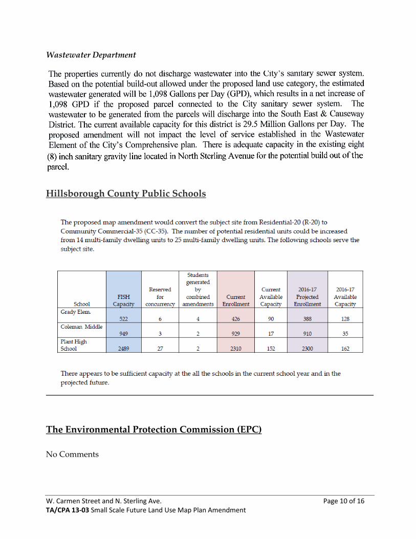
Hillsborough County Public Schools
The Environmental Protection Commission (EPC) No Comments
W. Carmen Street and N. Sterling Ave. Page 11 of 16 TA/CPA 13-03 Small Scale Future Land Use Map Plan Amendment
Hillsborough Area Regional Transit Authority (HART) Existing Service/ Future Needs There are four HART routes that travel within this vicinity. Route 36 (Dale Mabry/ Himes Avenue), Route 10 (Cypress Street), Route 30 (Downtown Tampa to Tampa International Airport /Town ’N Country) and Hurricane Evacuation Routes “H” and “I”. The routes travel on Dale Mabry Highway, Cypress Street, and Kennedy Boulevard. The transit hurricane emergency evacuation corridors for this location are Kennedy Boulevard and Dale Mabry. Routes 10 and 30 travel to the Downtown Marion Transit Center and the Westshore Plaza Transfer Center connecting to thirty-two routes including two routes operated by the Pinellas Suncoast Transit Authority. Route 36 travels to the West Tampa Transfer Center and the Britton Plaza Transfer Center and connects to eight routes. The major update of the HART Transit Development Plan 2012-2021 identifies Dale Mabry Highway and Kennedy Boulevard as potential corridors for MetroRapid service to improve service reliability and increase transit speed. Future Need-Capital Investment for Enhanced Transit Connection The proposed land use designation will create a need to connect to transit. Since Carmen Street and Cass Street connect to transit on Dale Mabry, HART recommends the renovation of the sidewalks along the north side of Carmen Street be incorporated into the Future Needs Plan. Future development must include internal pedestrian and bike connections to sidewalks that border the property to facilitate pedestrian/ADA connections to transit.
W. Carmen Street and N. Sterling Ave. Page 12 of 16 TA/CPA 13-03 Small Scale Future Land Use Map Plan Amendment
Attachment B
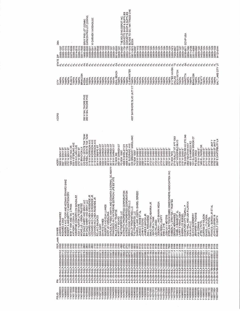
Map Series 1) TA CPA 13-03 – Aerial Map 2) TA CPA 13-03 – Existing Land Use Map 3) TA CPA 13-03 – Adopted Future Land Use Map 4) TA CPA 13-03 – Requested Future Land Use Map Change
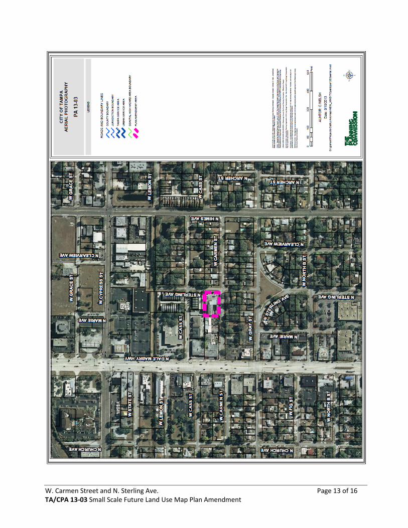
W. Carmen Street and N. Sterling Ave. Page 13 of 16 TA/CPA 13-03 Small Scale Future Land Use Map Plan Amendment
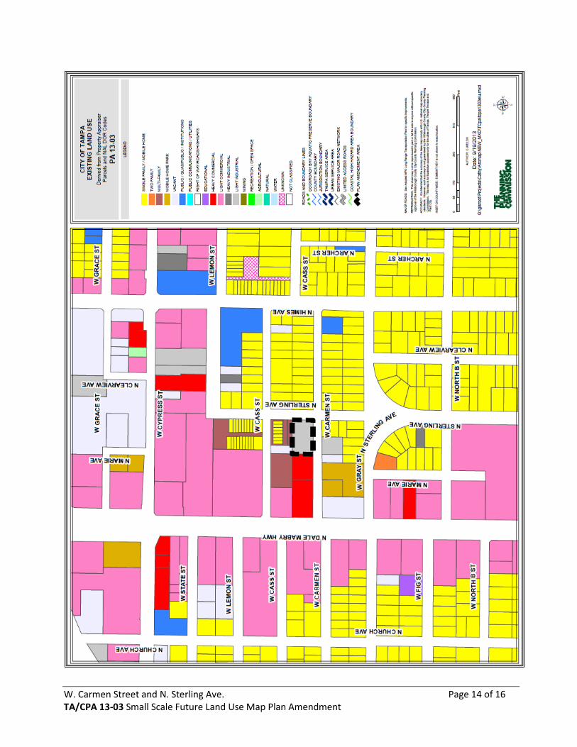
W. Carmen Street and N. Sterling Ave. Page 14 of 16 TA/CPA 13-03 Small Scale Future Land Use Map Plan Amendment
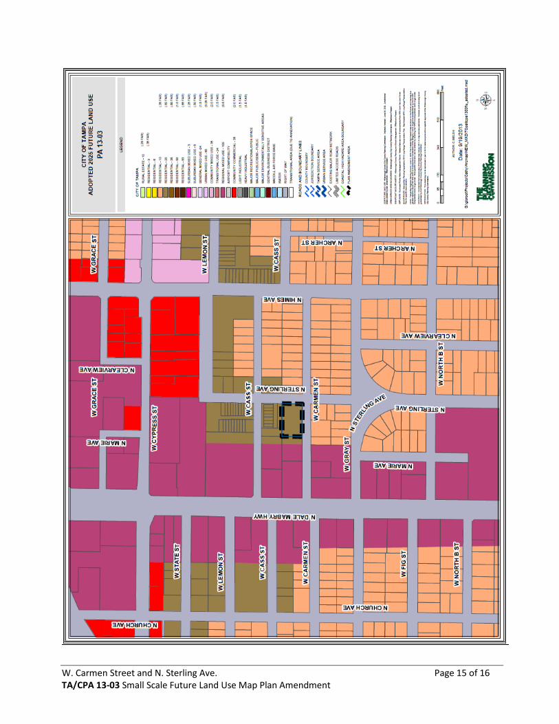
W. Carmen Street and N. Sterling Ave. Page 15 of 16 TA/CPA 13-03 Small Scale Future Land Use Map Plan Amendment
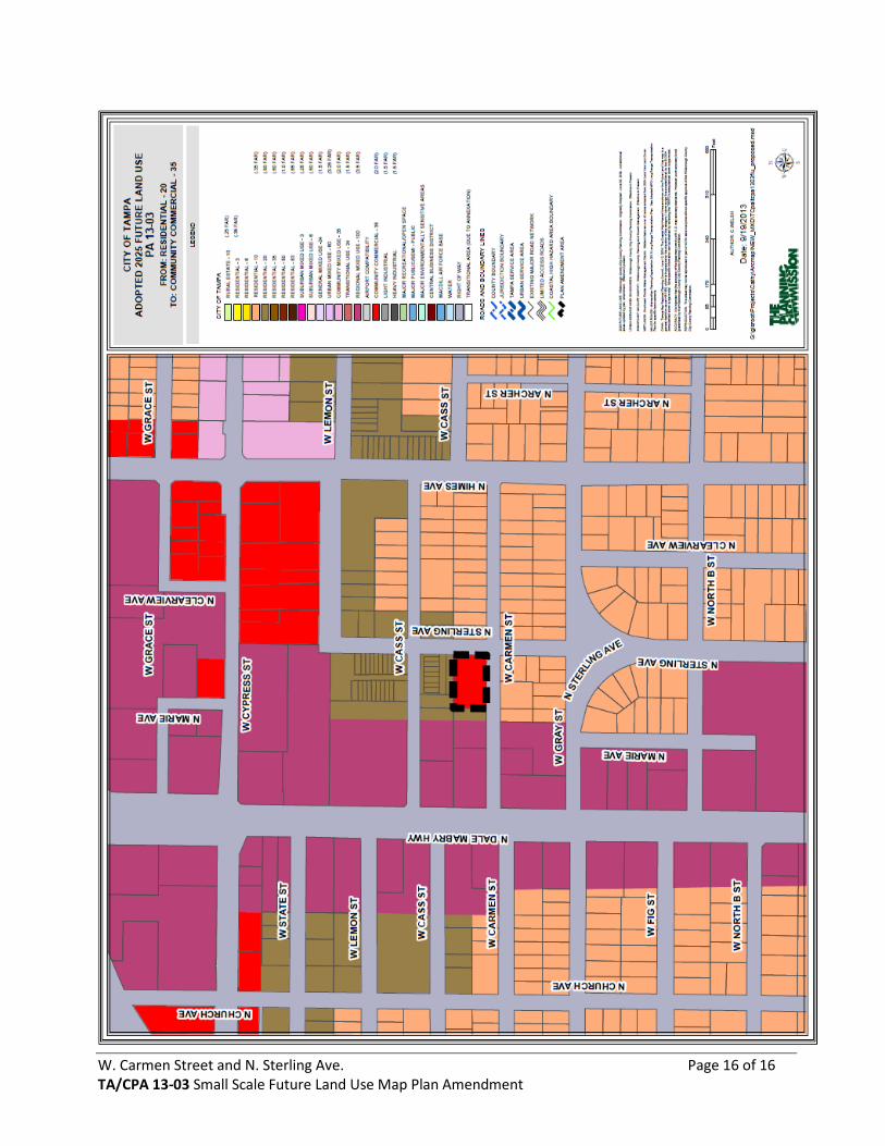
W. Carmen Street and N. Sterling Ave. Page 16 of 16 TA/CPA 13-03 Small Scale Future Land Use Map Plan Amendment