Dept. of Natural Resour.;-· Nat. Q)consisted of 35 mm Kodachrome colored slides; 35 mm infra red...
70
,. \.Jis Doc Nat. 39 Q) Department of Natural Resources Madison, Wis. 1969 Dept. of Natural Resour.;-·- T echnical Li .; r dry 3 911 Fish Hatchery Road fitchburg, Wl 53711 • 5397 AQUATIC PLANT SURVEY Of Major Lakes in the Fox ·I II inois· Watershed
Transcript of Dept. of Natural Resour.;-· Nat. Q)consisted of 35 mm Kodachrome colored slides; 35 mm infra red...
,.
\.Jis Doc Nat.
~: 4/ 39
Q)
Department of Natural Resources
Madison, Wis.
1969
Dept. of Natural Resour.;-·
Technical Li .;r dry 3911 Fish Hatchery Road fitchburg, Wl 53711 • 5397
AQUATIC PLANT SURVEY
Of Major Lakes in the Fox ·I II inois· Watershed
D. K. TYLER, Vice-Chairman
Phillips
HERBERT F. BEHNKE
Shawano
RUSSELL G. LYNCH
Wauwatosa
NATURAL RESOURCES BOARD
JOHN M. POTTER, Chairman
Wisconsin Rapids
GERARD A. ROHLICH, Secretary
Madison
-~ ARTHUR R. MacARTHUR
) anesville
CHARLES F. SMITH
Wausau
DEPARTMENT OF NATURAL RESOURCES
L. P. VOIGT
Secretary
JOHN A. BEALE
Deputy Secretary
f
•
•
•
•
AQUATIC PLANT SURVEY
OF MAJOR LAKES IN THE FOX RIVER (ILLINOIS) WATERSHED
By
Brian J. Belonger
Research Report No. 39
DEPARTMENT OF NATURAL RESOURCES Madison, Wisconsin 53701
1969 650-04

ACKNOWLEDGEMENTS
Grateful acknowledgement is made to Van Valaskey for valuable assistance in conducting the survey and preparing an aquatic plant reference collection; and Stanton Kleinert and Thomas Wirth for guidance and critical review of the report.
This survey was financed in part through a planning grant to the Southeastern Wisconsin Regional Planning Commission from the U.S. Department of Housing and Urban Development under the provisions of Section 701 of the Housing Act of 1954 as amended; and in part by funds authorized by Wisconsin Chapter 502, Laws of 1965, Accelerated Water Resources Research and Data Collection Program.
Edited by Ruth 1. Hine
•
•
•
ABSTRACT
An aquatic vegetation survey was conducted on 44 lakes of the Fox River Watershed. There was wide variation in abundance and diversity of vegetation among the lakes, ranging from dense with a high diversity to sparse with a low diversity. The genus Potamogeton was the most widely distributed, being found in every lake. The genus with the highest relative abundance was Chara, and was abundant in 31 of the 44 lakes surveyed.
Resurveys of the first twelve lakes were done in an attempt to describe vegetation changes from early to late summer. No major changes were revealed in'the distribution of plants, but seasonal variations in the amount of plant matter present were found .
ABSTRACT
INTRODUCTION
METHODS
RESULTS AND DISCUSSION
MANAGEMENT IMPLICATIONS
CONCLUSION
INDIVIDUAL LAKE SURVEY REPORTS
Lakes o~ Kenosha County Benedict Lake Benet and Shangrila Lake Camp Lake
Resurvey Center Lake Cross Lake Dyer Lake Lake Elizabeth Lilly Lake Marie Lake Powers Lake Rock Lake
Resurvey Silver Lake
Lakes of Racine County, Bohners Lake Browns Lake Lake Buena Eagle Lake
Resurvey Keenong Go Mong . Long Lake Lake Tichigan
Resurvey Lake Waubeesee
Resurvey Wind Lake
Resurvey
CONTENTS
Page
1
1
. 7 . 12
12
20
20 20 23 23 24 24 25 26 26 27 27 28 29 30 50
31 31 32 32 33 33 34 31+ 35 37 37 38 38 39

Lakes of Walworth County 39 Arrey Lake • 39 Lake Beulah 40
Resurvey . 41 Booth Lake 41 Lake Como • 42
Resurvey . 42 • Lake Geneva • 43
Ivanhoe Lake 43 Resurvey • 44
• Lauderdale Chain of Lakes 44 Lulu Lake 45 North Lake 1+6 Pell Lake 46 Peters Lake 47 Pleasant Lake 48 Potters Lake 48 Silver Lake 49 Wandawega Lake 50
Lakes of Waukesha County 51 Big Muskego Lake - :>1 Denoon Lake 52 Eagle Springs Lake 52 Little Muskego Lake 53
Resurvey 54 Lower Phantom Lake 54
Resurvey 55 Lake Pewaukee 5t:
Resurvey 57 Spring Lake - 58 Upper Phantom Lake 58
LITERATURE CITED 60
•
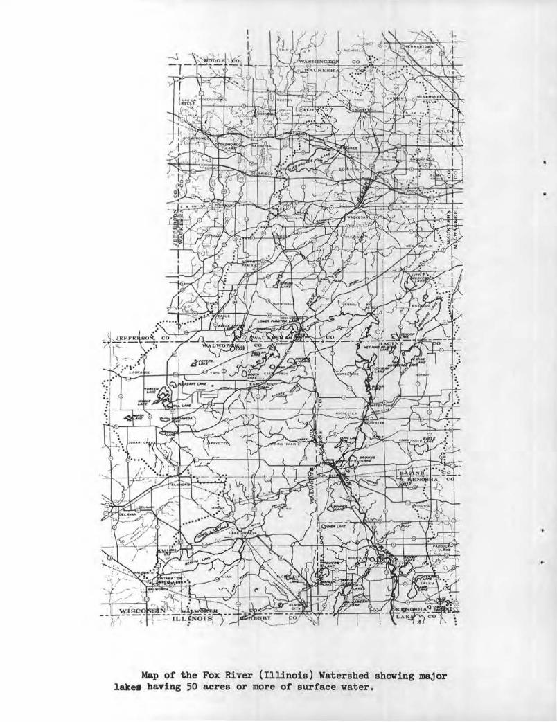
Map of the Fox River (Illinois) Watershed showing major lakel having 50 acres or more of surface water.
INTRODUCTION
An aquatic plant survey was undertaken during the summer of 1967 as a part of an effort to describe the natural resource base of the Fox River Watershed. The area of study was the headwater portion of an interstate river basin , with a 942-square- mile area located in Wisconsin.
There are 45 major lakes in the Fox River Watershed having 50 acres or more of surface water area , and 31 minor lakes with less than 50 acres . The lakes are mostly of glaci al origin, being natural, simple or compound depressions in gravelly outwash and moraine or ground moraine, and sometimes augmented by a low-head dam at the outlet. By virtue of their origin, these lakes are fairly regular in shape with their deepest points predictably near the center of the basin, or near the center of each of several connected basins. The beaches are characteristically gravel or sand on the wind-swept north , east and south shores while fine sediments and encroaching vegetation are common on the protected west shores and in the bays.
The primary purpose of the aquatic plant survey was to determine the distribution and abundance of aquatic plants with reference to their possible impact upon man ' s recreational activities and fish and wildlife, and to establish a record of the present status of aquatic plants for possible future reference.
METHODS
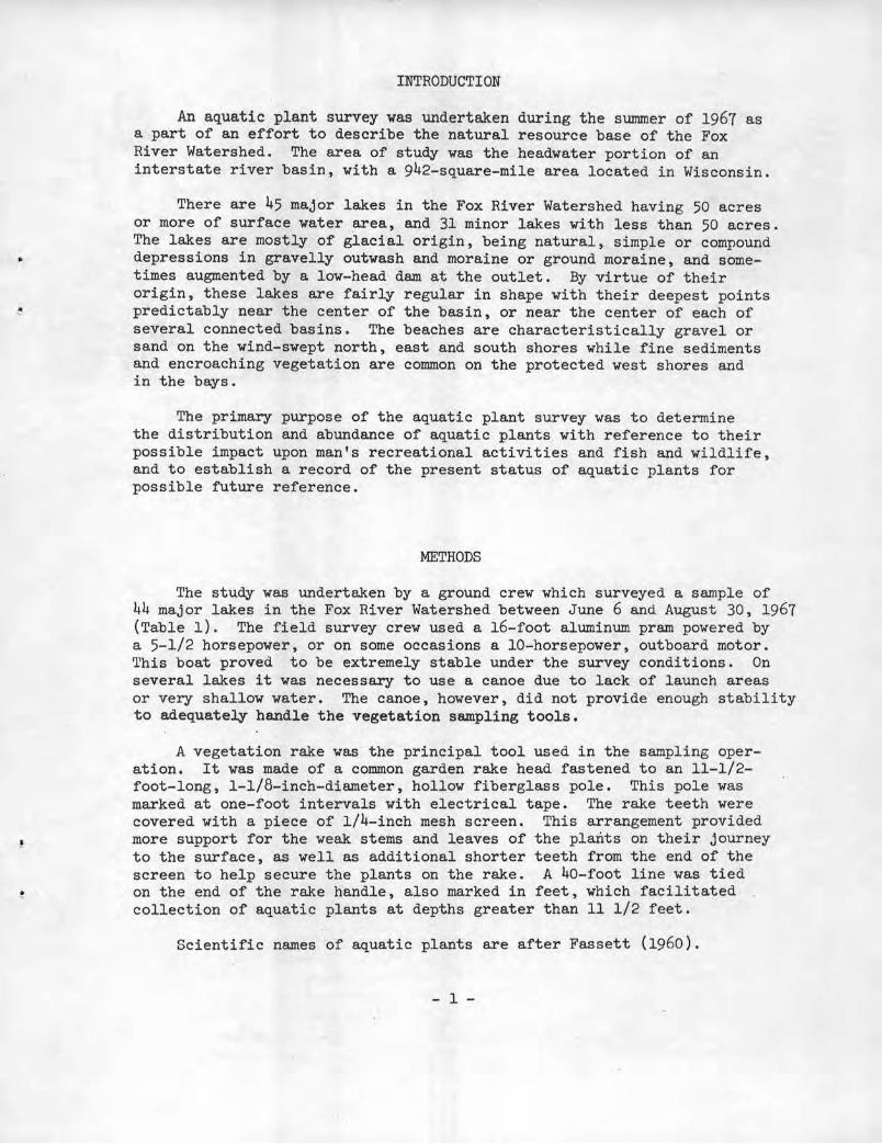
The study was undertaken by a ground crew which surveyed a sample of 44 major lakes in the Fox River Watershed between June 6 and August 30 , 1967 (Table 1) . The field survey crew used a 16- foot aluminum pram powered by a 5-1/2 horsepower, or on some occasions a 10-horsepower, outboard motor. This boat proved to be extremely stable under the survey conditions . On several lakes it was necessary to use a canoe due to lack of launch areas or very shallow water. The canoe, however, did not provide enough stability to adequately handle the vegetation sampl ing tool s.
A vegetation rake was the principal tool used in the sampling operation . It was made of a common garden rake head fastened to an 11-1/2-foot-long, 1-1/8-inch-diameter, hollow fiberglass pole. This pole was marked at one- foot intervals with electrical tape. The rake teeth were covered with a piece of 1/4- inch mesh screen. This arrangement provided more support for the weak stems and leaves of the plants on their journey to the surface, as well as additional shorter teeth from the end of the screen to help secure the plants on the rake. A 40-foot line was tied on the end of the rake handle, also marked in feet, which facilitated collection of aquatic plants at depths greater than 11 1/2 feet .
Scientific names of aquatic plants are after Fassett (1960).
- 1-
Aquatic plant survey crew.
TABLE 1
Identif.ying submerged vegetation collected using the vegetation rake.
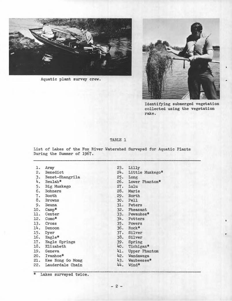
List of Lakes of the Fox River Watershed Surveyed for Aquatic Plants During the Summer of 1967.
1. Arrey 23. Lilly 2. Benedict 24. Little Muskego* 3. Benet-Shangrila 25. Long 4. Beulah* 26. Lower Phantom* 5. Big Muskego 27. Lulu 6. Bohners 28. Marie 7. Booth 29. North 8. Browns 30. Pell 9. Be una 31. Peters
10. Camp* 32. Pheasant 11. Center 33. Pewaukee* 12. Como* 34. Potters 13. Cross 35. Powers 14. Denoon 36. Rock* 15. Dyer 37. Silver 16. Eagle* 38. Silver 17. Eagle Springs 39. Spring 18. Elizabeth 40. Tichigan* 19. Geneva 41. Upper Phantom 20. Ivanhoe* 42. Wandawega 21. Kee Nong Go Mong 43. Waubeesee* 22. Lauderdale Chain 44. Wind*
* Lakes surveyed twice.
- 2 -
..
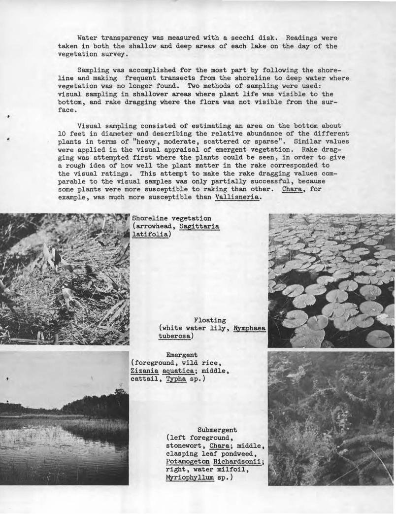
Water transparency was measured with a secchi disk. Readings were taken in both the shallow and deep areas of each lake on the day of the vegetation survey.
Sampling was accomplished for the most part by following the shoreline and making frequent transects from the shoreline to deep water where vegetation was no longer found. Two methods of sampling were used: visual sampling in shallower areas where plant life was visible to the bottom, and rake dragging where the flora was not visible from the surface.
Visual sampling consisted of estimating an area on the bottom about 10 feet in diameter and describing the relative abundance of the different plants in terms of "heavy, moderate, scattered or sparse". Similar values were applied in the visual appraisal of emergent vegetation. Rake dragging was attempted first where the plants could be seen, in order to give a rough idea of how well the plant matter in the rake corresponded to the visual ratings. This attempt to make the rake dragging values comparable to the visual samples was only partially successful, because some plants were more susceptible to raking than other. Chara, for example, was much more susceptible than Vallisneria.
~~B~!~Sj~Rrl"J'~~ Shoreline vegetation (arrowhead, Sagi ttaria
-.-.. ..... ...._ latifolia)
Floating (white water lily, Nymphae a tuberosa)
Emergent (foreground, wild rice, Zizania aquatica; middle, cattail, Typha sp.)
Submergent (left foreground, stonewort, Chara; middle, clasping leaf pondweed, Potamogeton .Richardsonii; right, water milfoil, Myriophyllum sp.)
Field observations were recorded on a contour map of each lake on the day of the survey with a number, letter and colored circle . Each number represented a separate genus and each letter a separate species . Plants were identified only to genus, except for the Potamogetons and certain other species. In one case, the whole family Cyperaceae was represented by the number (except for Scirpus validus) because of the extreme difficulty in identifying members of the family to genus when not in fruit. Since different taxonomic levels were involved in identifying the vegetation (family, genus, species), the terms "plant type" or "plant description" were used when referring to these groups collectively. The color code consisted of a black , red, blue or green circle placed around each number-letter code. These colors represented in the order given, heavy, moderate , scattered, and sparse ratings for each taxonomic grouping at each sample area . This code system allowed rapid recording on the lake survey maps of the kind of plant present, its relative abundance and the approximate location in the lake where it was observed.
Numerical values were assigned to the relative abundance classification to take into consideration the total area covered by each plant type in the lake : heavy , 12; moderate, 4; scattered, 1; and sparse, 1/4. These points were then totalled for each plant type in all lakes to arrive at its contribution to the total flora.
A truly precise estimate for the number of lakes surveyed would have involved an unrealistic amount of work and time. Vegetation surveys were conducted on 44 lakes once, except for the first 12 which were surveyed twice. This resulted in 56 surveys in 59 work days. The visual and drag rake techniques of sampling leave much to be desired. The aquatic plant survey techniques employed by Swindale and Curtis (1957) and Jessen and Lound (1962) are superior to those used in this survey but lack of time prohibited their use.
Aerial photographs were taken of the surveyed lakes. The photographs consisted of 35 mm Kodachrome colored slides; 35 mm infra red slides; and 9x9-inch transparencies taken with Kodak Ectachrome Aero Film (infra red), Type 8442, at an altitude to provide a scale of 1 inch = 4oo feet. When exposure , angle, and atmospheric conditions are judged correctly, these slides show aquatic vegetation for moderate distances below the surface. The color slides and 9x9-inch transparencies could prove to be an adequate tool for mapping major vegetation beds and recording changes in vegetation . The latter may prove to be the best method if reflection and exposure can be corrected . The advantage of these pictures is more area can be covered on a single exposure resulting in less time spent on orientation. The best approach for using these slides appears to be examination of the photographs as soon as possible after they are taken and ground checking questionable areas. The time lapse between taking the pictures and. examining them should be minimized for best results . Some major problems in mapping involve separating bottom from vegetation, distinguishing between plants of about the same color, and adjusting for angular distortion.
- 4 -
•
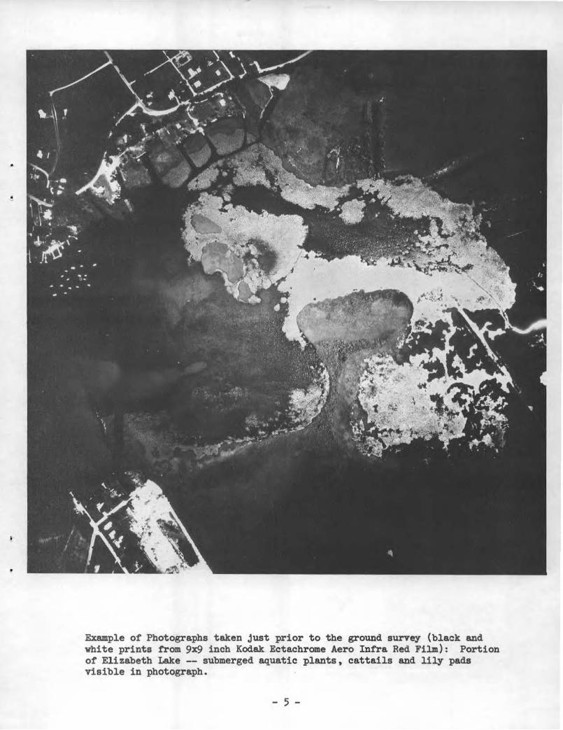
Example of Photographs taken just prior to the ground survey (black and white prints from 9x9 inch Kodak Ectachrome Aero Infra Red Film): Portion of Elizabeth Lake -- submerged aquatic plants, cattails and lily pads visible in photograph.
- 5 -

Example of photographs taken just prior to the ground survey (black and vhi te prints from 9x9 inch Kodak Ectachrome Aero Intra Red Film) : Ivanhoe Lake-- submerged aquatic plants, cattails and lily pads visible in photograph.
• 6 -
•
RESULTS AND DISCUSSION
A list of aquatic plants found during the survey is presented in Table 2. The presence and relative abundance of each plant type observed are summarized in Tables 3 and 4 for all 44 lakes sampled, and are recorded for each lake in Table 6. The percentage contribution of each plant type to the total vegetation of the 44 lakes sampled is presented in Tables 3 and 4.
With few exceptions lakes had moderate to abundant vegetation in many areas from shore to depths as great as 30 feet. In general, lakes with combinations of extensive shallow areas, clear water, and muck bottoms appeared to have more vegetation per acre than lakes with combinations of limited shallow areas, either turbid or dark-colored water, and sand or gravel bottoms. It has been shown by Curtis (1959) that lakes in southern Wisconsin contained 300 to 2,500 times as much plant material per unit area as lakes in northern Wisconsin. The same worker found that this greater plant production corresponded to the geographic region of very hard, alkaline waters with high conductivity characteristic of lakes in southern Wisconsin. During the survey there was a continuum of abundances which ranged from Lake Geneva with relatively little plant life to lakes such as Lower Phantom which had an abundance of plants over its entire basin.
The diversity of the aquatic plant communities varied considerably over the lakes surveyed in the Fox River Watershed. A continuum of variation was noted ranging from only a few genera present (as in Browns Lake, with 3 genera recorded) to many different genera contributing appreciably to the flora (as in the Lauderdale chain, with 21 genera recorded). The average number of genera found per lake was 12.6. Curtis (1959) felt that although the submerged environment is homogeneous, the communities are diverse in their composition and show surprising variation over short distances. He lists as major environmental controls affecting diversity, water depth as related to light intensity, water chemistry, water movement, and nature of the substrate.
A human factor, herbicide spraying, may be decreasing diversity. There is not enough evidence to substantiate this, but Lake Pewaukee may prove to be an example. The lake has a very high level of herbicide spraying and has the least amount of diversity of any lake surveyed -- diversity being based on the number of genera contributing appreciably to the lake flora. One genus and probably only one species, Myriophyllum exalbescens, accounted for about 98 percent of the vegetation in the lake. The herbicide application may be less effective against this plant resulting in its increasing role in the lake's vegetation. The effect of mechanical harvesting of aquatic plants cannot be substantiated from the survey. However, there is a possibility that some plants are more affected than others because of their different physiological reactions resulting in some species increasing and others decreasing.
Some of the lakes surveyed had unusually rank aquatic plant growth or extensive algae blooms. These situations may indicate pollution by unnatural enrichment. Some of the lakes exhibiting super abundances of plants include Camp, Eagle Spring, Lilly, Little Huskego, Lower Phantom, Pell, Wandawega and Tichigan. The problem in 'l'ichigan is primarily algae, although higher aquatic plants are extremely abundant in some areas.
- 7 -
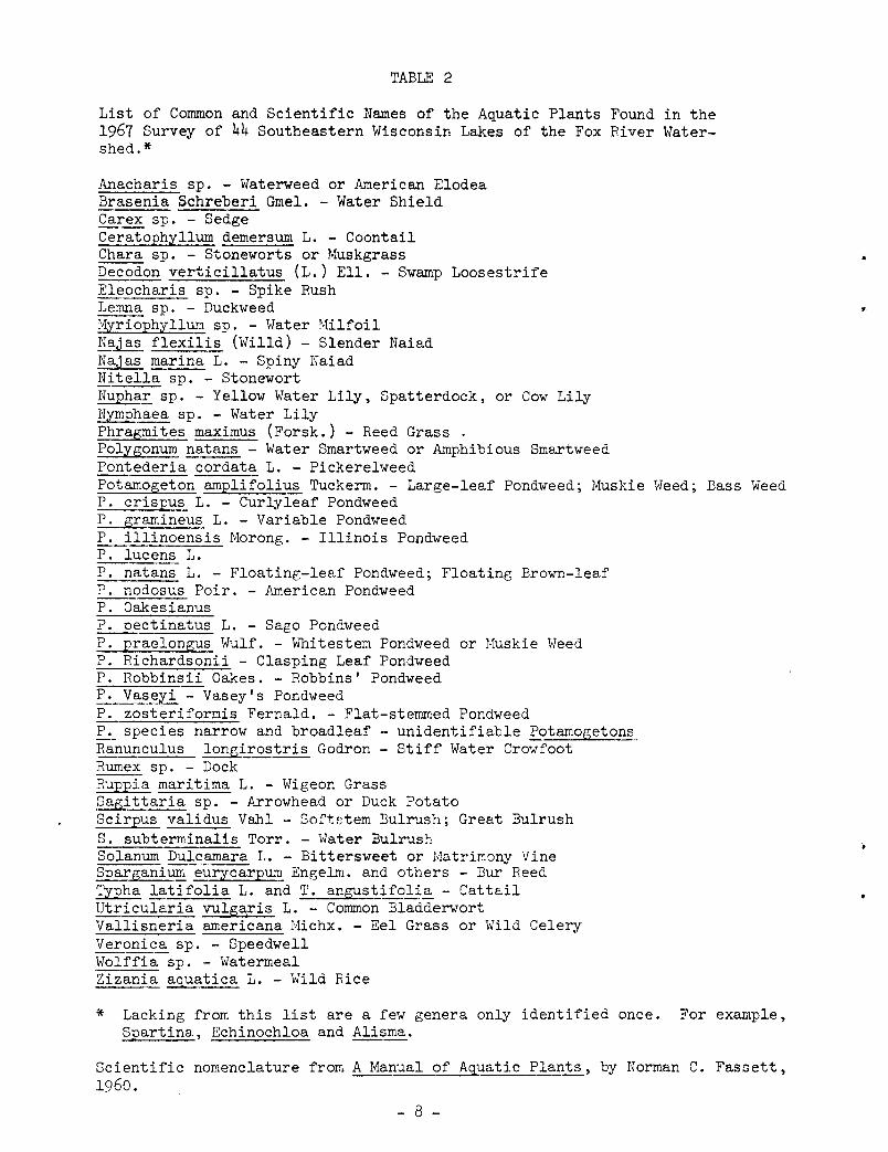
TABLE 2
List of Common and Scientific Names of the Aquatic Plants Found in the 1967 Survey of 44 Southeastern Wisconsin Lakes of the Fox River Watershed.*
Anacharis sp. - Waterweed or American Elodea Brasenia Schreberi Gmel. - Water Shield Carex sp. - Sedge Ceratophyllum demersum L. - Coontail Chara sp. - Stoneworts or Muskgrass Decodon verticillatus (L.) Ell.- Swamp Loosestrife Eleocharis sp. - Spike Rush Lemna sp. - Duckweed ~riophyllum sp. - Water Milfoil Najas flexilis (Willd) - Slender Naiad Najas marina L. - Spiny Naiad Nitella sp. - Stonewort Nupha~ sp. - Yellow Water Lily, Spatterdock, or Cow Lily Nymphaea sp. - Water Lily Phragmites maximus (Forsk.)- Reed Grass . Polygonum natans - Water Smartweed or Amphibious Smartweed Pontederia cordata L. - Pickerelweed Potamogeton amplifolius Tuckerm. - Large-leaf Pondweed; Muskie Weed; Bass Weed P. crispus L. - Curlyleaf Pondweed P. gramineus L. - Variable Pondweed P. illinoensis Morang. - Illinois Pondweed P. lucens L. P. natans L. - Floating-leaf Pondweed; Floating Brown-leaf P. nodosus Pair. - American Pondweed P. Oakesianus ~ctinatus L. - Sago Pondweed P. praelongus Wulf. - Whitestem Pondweed or Muskie Weed P. Richardsonii - Clasping Leaf Pondweed P. Robbinsii Oakes. -Robbins' Pondweed P._Va~~~- Vasey's Pondweed P. zosteriformis Fernald. - Flat-stemmed Pondweed P~ species narrow and broadleaf - unidentifiable Potamogetons Ranunculus longirostris Godron - Stiff Water Crowfoot Rumex sp. - Dock Ruppia maritima L. - Wigeon Grass Sagittaria sp. - Arrowhead or Duck Potato Scirpus validus Va.hl - Soft~:tem Bulrush; Great Bulrush S. subterminalis Torr. - Water Bulrush Solanum Dulcamara L. - Bittersweet or Matrirr.cmy Vine Spargani~ -eurycarpum Engelm. and others - Bur Reed Typha latifolia L. and T. an~ifoli.§._ - Cattail Utricularia vulga,ris L. - Common Bladderwort Vallisneria americana Michx. - Eel Grass or Wild Celery Veronica sp. - Speedwell Wolffia sp. - Watermeal Zizania aquatica L. - Wild Rice
* Lacking from this list are a few genera only identified once. For example, Spartina, Echinochloa and Alisma.
Scientific nomenclature from A Manual of Aquatic Plants, by Norman C. Fassett, 1960.
- 8 -
"

•
The distribution of life forms generally followed the classical pattern associated with increase in depth. The plants changed with increasing depth from emergent to floating leaf and finally submergent species.
Many areas graded from nonaquatic directly into submerged or from emergent or floating leaf to submergent species. Emergent species were confined to areas with a depth less than about 3 feet. The Cyperaceae, Decodon, Phragmites, Polygonum, Rumex, Sagittaria, Sparganium and Typha latifolia were most often found in very shallow water; while Typha angustifolia, Pontederia, Scirpus validus and Zizania were usually found in the deeper areas occupied by emergents. Floating-leafed plants were generally found to depths of 4 feet. The floating leaves of Potamogeton natans occurred in water as deep as 7 feet. Lemna, a free-floating aquatic plant, was capable of drifting over very deep areas. Of the two most conspicuous floating-leafed plants, Nymphaea and Nuphar, the latter was usually found in deeper water. Submergent vegetation was found as deep as 30 feet but rarely occurred near the surface in water exceeding 12 feet deep. Chara and Potamogeton were common in water less than about 8 feet deep. MYriophyllum, Najas, and Ceratophyllum were common in both shallow and deep water, while Nitella was never found in water shallower than about 13 feet.
The first 12 lakes surveyed were resurveyed in the latter part of August to detect possible changes in vegetation. The average time lapse between surveys was 70 days. Several changes were observed in the abundance of some of the survey plants while in general their distribution remained about the same. Swindale and Curtis (1957) found that relative frequency of plants did not change much between June 28 and September 19, but that many plants varied as to the amount of vegetative matter present. This does not mean that appreciable changes cannot occur over relatively short periods. Dane (1959) reported noticeable changes in aquatic plant distribution in New York ponds over a period of only 3 years.
Genera which showed the greatest increase in abundance in the resurveyed lakes were Najas, Vallisneria, Potamogeton pectinatus, unidentified broad-leaved Potamogetons, Lemna, Pontederia, and Scirpus americanus. Najas flexilis and N. marina both increased considerably. Najas flexilis was found in moderate amounts even during the first surveys but N. marina only began to be found about mid-July. Vallisneria showed dramatic increases in several of the resurveyed lakes probably due to the rapid vegetative reproduction characteristic of the plant.
Plants that exhibited the greatest decrease over the survey period included Anacharis, Potamogeton natans, P. crispus, P. praelongus and Ranunculus. The latter three afforded the most striking examples of this, being completely lacking from some areas in which they were found during the first surveys.
Secchi disk readings often varied over the extent of a lake being surveyed. In general, the disk was visible to greater depths in deeper areas than in the shallows. However, the reverse was true in areas such as Muskego Lake where secchi disk readings showed some of the shallows to be clearer than the deep water areas. Secchi disk readings ranged from less than a foot in several lakes to 18 feet in Lake Waubeesee.
- 9 -

TABLE 3
Relative Abundance and Presence of Plant Types
Percent of Percent Total Occurrence
Plant Types Vegetation in Lakes
Chara (Stoneworts) 18.7 93.1 Potamogeton (Pondweeds) 16.8 100.0 P. Eectinatus 3.6 91.1 P. natans 2.6 70.4 .. P. amElifolius 2.5 38.6 P. 12raelongus 2.3 43.1 ~ sp. (narrow leaf) 1.3 75.0 P. zosteriformis 1.5 45.4 P. criS£US 1.5 52.2 !:..:.. sp. (broad leaf) M* 34.0 P. illinoensis .9 22.7 P. gramineus .6 38.6 P. Robbinsii M 20.4 P. nodosus M 25.0 P. Oakesianus M 4.5 P. Richardsonii M 6.8 P. lucens M 4.5 P. Vaseyi M 2.2 M~rioEh~llum (Water Milfoil) 8.5 88.6 Ty£ha (Cattail) 7 .. 2 84.0 Najas (Spiny Naiad) 6.8 61.3 Nuphar (Yellow Water Lily) 6.2 81.8 Nymphaea (Water Lily) 5.9 88.6 Scir£US validu~ (Softstem Bulrush) 5.8 86.3 CeratoEhyllum (Coontail) 4.3 61.3 Cyperaceae [,excluding Scir£US validus) 3.8 72.7 Vallisneria (Eel Grass) 2.8 59.0 Decodon (Loosestrife) 2.6 45.4 Nitella (Stonewort) 2.5 29.7 Ru£pia (Wigeon Grass) 2.3 9.0 Lerona (Duckweed) 1.9 22.7 Anacharis (Waterweed) .1 50.0 Utricularia (Bladderwort) .1 45.4 Pontederia (Pickerelweed) .1 20.4 Sagittaria (Arrowhead) . 5 36.3 S£arganium (Bur Reed) M 31.8 Brasenia (Water Shield) M 6.8 Wolffia (Watermea~) M 4.5 Ranunculus (Crowfoot) M 22.7 Zizania (Wild Rice) M 11.3 Rumex (Dock) M 18.1 Polygonum (Smart weed) M 13.6 Phra~ites (Reed Grass) M 6.8
* M = minor. - 10 -
•
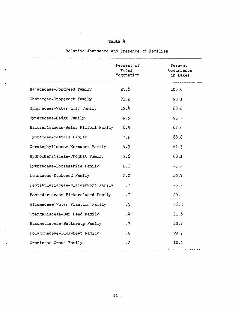
TABLE 4
Relative Abundance and Presence of Families
Percent of Total
Vegetation
Najadaceae-Pondweed Family 25.8
Characeae-Stonewort Family 21.2
Nymphaceae-Water Lily Family 12.4
Cyperaceae-Sedge Family 9.5
Haloragidaceae-Water Milfoil Family 8.5
Typhaceae-Cattail Family 7.2
Ceratophyllaceae-Hornwort Family 4.3
Hydrocharitaceae-Frogbit Family 3.6
Lythraceae-Loosestrife Family 2.6
Lemnaceae-Duckweed Family 2.2
Lentibulariaceae-Bladderwort Family .7
Pontederiaceae-Pickerelweed Family .7
Alismaceae-Water Plantain Family .5
Sparganiaceae-Bur Reed Family .4
Ranunculaceae-Buttercup Family .3
Polygonaceae-Buckwheat Family .2
Gramineae-Grass Family .2
- 11 -
Percent Occurrence in Lakes
100.0
93.1
88.6
95.4
87.6
88.6
61.3
68.1
45.4
22.7
45.4
20.4
36.3
31.8
22.7
29.7
18.1
-----
MANAGEMENT IMPLICATIONS
Very little wildlife was seen at the lakes during the surveys. The large amount of shoreline use, such as cottages, beaches and piers on most lakes, may be a factor contributing to the lack of wildlife. It must be pointed out, however, that the surveys were not conducted during the hours of peak activity for most species of wildlife. During the resurveys in late August, ducks began to appear on the lakes with increasing regularity.
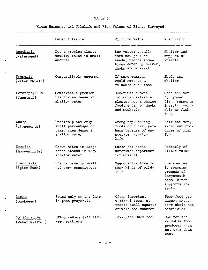
A listing of the values of the aquatic plants encountered for fish and wildlife and their present nuisance level for humans in surveyed lakes is presented in Table 5. The values for fish and wildlife have been taken from Fassett (1960) and Martin, Zim and Nelson (1951). The present nuisance level comments stem from observations made on the summer survey.
When considering the fish and wildlife values of the plants, it should be kept in mind that any plant when overabundant can have ill effects on these resources.
CONCLUSION
Vegetation pl~s an important role in the type of use a lake is able to receive. Fishing, boating, and swimming can all be adversely affected by dense aquatic plant and algae growth. These conditions have been described for some of the surveyed lakes. Periodic surveys may help identify lakes in which the amount of vegetation is rapidly increasing, and situations where pollution may be contributing nutrients to our waters.
- 12 -
•
•
TABLE 5
Human Nuisance and Wildlife and Fish Values of Plants Surveyed
Anacharis (Waterweed)
Brasenia (Water Shield)
Ceratophyllum (Coontail)
Char a (stoneworts)
Decodon (Loosestrife)
Eleocharis (Spike Hush)
Lemna (Duckweed)
Myriophyllum (Water Milfoil)
Human Nuisance
Not a problem plant; usually found in small amounts
Comparatively uncommon
Sometimes a problem plant when dense in shallow water
Problem plant only small percentage of time, when dense in shallow water
Grows often in large dense stands in very shallow water
Stands usually small, not very conspicuous
Found only on one lake in pest proportions
Often causes extensive weed problems
- 13 -
Wildlife Value
Low value; usually does not produce seeds; plants sometimes eaten by beaver, ducks and muskrat
If more common, would rate as a valuable duck food
Sometimes crowds out more desirable plants; not a choice food; eaten by ducks and muskrats
Among top-ranking foods of ducks; perhaps because of associated aquatic life
Ducks eat seeds; sometimes important for muskrat
Seeds attractive to many kinds of wildlife
Often important wildfowl food; attracts small aquatic animals and muskrat
Low-r,rade duck food
Fish Value
Shelter and support of insects
Shade and shelter
Good shelter for young fish; supports insects; valuable as fish food
Fair shelter; excellent producer of fish food
Probably of little value
One species is spawning grounds of largemouth bass; often supports insects
Poor food producer; excessive shade not beneficial
Shelter and valuable food producer when not over-abundant
IJajas (Naiad)
Nitella (Stonewort)
Nuphar (Spatterdock)
Nymphae a (Water Lily)
Phragmi t~J?. (Reed Grass)
Polygon~.
(Smartweed)
Pontederia (Pickerelweed)
?otrunogeton (Pondweed)
Ranunculus (Crowfoot)
Rumex --(Dock)
TABLE 5 (cent. )
Human Nuisance
Sometimes causes problems in later summer
No problem, grows in deep water
Sometimes causes problems because of the extensiveness of the beds
Usually not abundant enough to be a problem
Never abundant enough to cause problem
Usually not abundant enough to be nuisance
Some species cause nuisance problems because of their abundance
Never found abundantly enough to cause problems
Not abundant enough to cause problems
- 14 -
Wildlife Value
Stems, foliage and seeds eaten; among choicest eastern duck foods
May support small animal life; eaten by diving ducks
Seeds eaten by ducks; stems eaten by deer, porcupine; beaver and muskrat eat roots
Attracts wildfowl and shorebirds; parts eaten by muskrat, beaver, deer, moose, and porcupine
Little or no value as wildfowl food; muskrats eat
Seeds eaten by waterfowl, marsh, and songbirds, muskrat, raccoon and squirrel
Seeds eaten by ducks; good muskrat food
Staple for ducks; attractive to marsh birds, shorebirds, muskrat, deer and beaver
Aquatic species probably of little value
Nutlets eaten by wildfowl; attracts songbirds; heavily browsed by deer
Fish Value
Good food producer; provides good shelter
Fair shelter; supports insects; valuable for food
Shelter and shade; leaves harbor insects
Negative value when too dense
Probably of little value
Produces food and cover
Mainly shade and shelter
Food and sheJ.ter; leaves eaten by bluegills
Fair food producer for trout
Fair food producer for trout
,,
•

•
Ruppia (Wigeon Grass)
Sagittaria (Arrowhead)
S9irpus (Bulrush)
Sparganium (Bur Reed)
Typha (Cattail)
Utricularia (Bladderwort)
Vallisneria (Eel Grass)
Wolffia (Watermeal)
Zizania (Wild Rice)
TABLE 5 (cont.)
Human Nuisance
Seldom found but when found usually very dense
Often not dense, usually not a problem
Sometimes forms extensive stands which may influence human activity
Not often dense; usually not a problem
Often in dense stands; may sometimes be undesirable
Never abundant enough to be a problem
Sometimes forms dense growths; undesirable in swimming areas
Can cause undesirable surface growths; usually associated with Lemna
Never found overabundantly
- 15 -
Wildlife Value
Often important duck food
Tubers and nutlets eaten by waterfowl, muskrat , porcupine, and beaver
Seeds provide good food for wildfowl, shorebirds , and marsh birds; provides nesting cover; stems and underground parts eaten
Essentially a cover plant; attracts marsh birds and waterfowl; heavily eaten by muskrats
Important food of muskrat and beaver; attracts marshbirds; questionable waterfowl value
Probably only slightly used
Excellent waterfowl food; also eaten by muskrat
Often good waterfowl food
Importance perhaps overestimated in view of local and seasonal availability
Fish Value
Excellent food and cover
Shade and shelter
Spawning grounds; shelter and support for insects
Supports insects
Good food and cover
Good food and cover
Valuable fish food
Eaten by carp; of doubtful value

Swamp loosestrife, Decodon
Arrowhead, Sagi ttaria, with submerged rosette of ·leaves (above); s. latifolia, average leaf for.m-(above, right) and narrow leaf form (below, right)
- 16 -
•

•
j
Yellow water lily or spatterdock, Nuphar
Duckweed, Lemna minor
(right) Pickerelweed, Pontederia cordata
Sottstem bulrush, Scirpus validus
II
Cattail, TYpha sp.

CUrly leaf pondweed, Potamogeton crispus
Sago pondweed, Potamogeton pectinatus
Floating-leaf pondweed, Potamogeton natans
Large-leaf pondweed, Potamogeton ampli:folius
Clasping leaf pondweed, Potamogeton Richardsonii
'
,
..
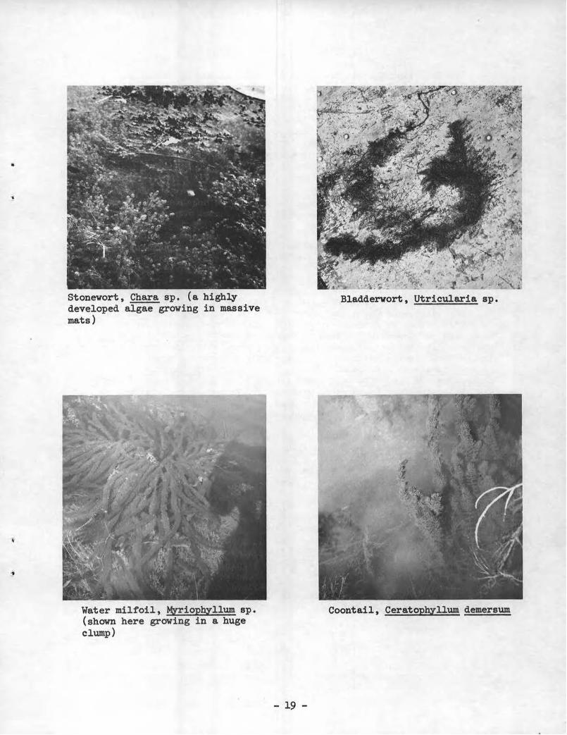
Stonewort, Chara sp. (a highly developed algae growing in massive mats)
Water milfoil, MYriophyllum sp. (shown here growing in a huge clump)
Bladderwort, Utricularia sp.
Coontail, Ceratophyllum demersum
- 19 -
INDIVIDUAL LAKE SURVEY REPORTS
The following reports cover the distribution and abundance of aquatic plants in the 44 lakes of the Fox River Watershed surveyed between June 6 and August 30 , 1967. These reports also contain information concerning the size of the lakes, the depth and slope of the bottom, water clarity, public use of the lake while each survey was in progress, and in some lakes, the measures used to control plant problems. The latter information is very sketchy for it is based on contacts with only a few local people . Presence and relative abundance of aquatic plants found in each lake are shown in Table 6.
Lakes of Kenosha County
Benedict Lake August 3
Benedict is a 78-acre lake with a bottom that slopes gradually on the northwest side and more steeply on the remaining sides. The water was relatively clear, with secchi disk readings of 10 feet. The maximum depth extent of vegetation was 25 feet .
From shore to a depth of about 17 feet, MYriophyllum was the most abundant plant, and Chara was second. The MYriophyllum formed a rather dark belt along the shoreline while the Chara formed small dense to scattered patches over the sand bottom areas. Potamogeton illinoensis was probably the most abundant Potamogeton species in this depth range (shore to 17 feet), while some P. pectinatus and several other Potamogetons were also found. Najas, Vallisneria, Utricularia, Ranunculus and Anacharis were other genera found from shore to 17 feet, with Najas the only one present with any frequency . The flora from a depth of 18 to 25 feet consisted mainly of Nitella with small amounts of MOCriophyllum, Potamogeton crispus, and Utricularia also present.
Floating leaf plants consisted of one bed of Nuphar and only a few small beds of Nymphaea scattered along the shore.
Emergents consisted of several small areas of Scirpus validus and Decodon. This grass marsh on the south side of the lake was too dry to have emergent species.
The lake does have a weed problem in many shallower areas mainly because the MYriophyllum comes near the surface.
Lake use during the survey consisted of three pleasure boats, one being rowed and two under motor power, one boat pulling a water skier, and one person in a boat fishing.
A vegetation harvester is used on the lake, but the status of herbicide application is unknown.
- 20 -
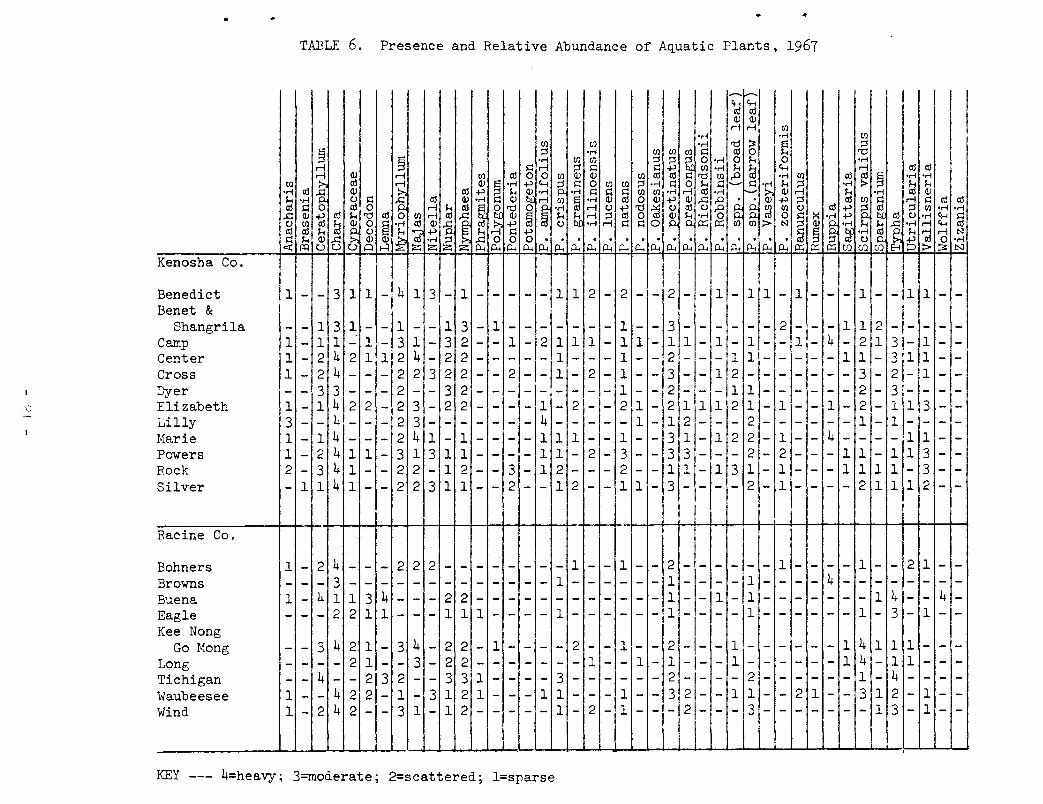
Kenosha Co.
Benedict Benet &
Shangrila Camp Center Cross Dyer Elizabeth Lilly Marie Powers Rock Silver
Racine Co.
Bohners Browns Buena Eagle Kee Nong
Go Mong Long Tichigan Waubeesee Wind
.. ..
TABLE 6. Presence and Relative Abundance of Aquatic Plants, 1967
I 1 - - 3 1 1 - 4 1 3 - 1 - - - - - 1 1 2 - 2 - - 2 - - 1 - 1 1 - 1 - - - 1 - - 1 1 - -
I I - - 1 3 1- -11-- 1 3- 1- -1--- -- 1-- 3 -- - - - - 2- _,_ 1 1 2- --- -1 - 1 1 ~ 1 - 3 1 - 3 2- - 1 - 2 1 1 1- 1 1 - 1 1- 1 - 1 - lj- 4 2 1 31- 1 - -1- 2 4 2 1 1 2 4- 2 2----- 1--- 1-- 2-- -,11 1- -'-- 1 1 -1311 1--1 - 2 4-- - 2 2 3 2 2-- 2- -11- 2- 1- -13-- 1 2 -1- -1- - 3'- 21- 1-- -·3 3--- 2-- 3 2--- -1--- -,- 1-- 2-- -11 1- --- 2- 3!- --1 - 1 4 2 2 - 2 3 - 2 2 - _- _- -_ 14 _- 2_ - - 2 1'- 2 1 1 1 2 1 - 1 - - 1- 2- 1 1 3 --3-- 4'--- 2 3---- - 1- 1 2--- 2------ 1- 1----1 - 1 4 - - - 2 4 1 - 1 - - - - 1 1 1 -1- 1 - - 3 1 - 1 2 2 - 1 - - 4 - - - - 1 1 - -1- 2 4 1 1- 3 1 311 1---- 1 1- 2- 3- - 3 3- - - 2- 2- - - 1 1 - 1 1 3 - -2 - 3 4 1 - - 2 2 - 1 2 - - 3 - 1 2 - - - 2 - - 1,1,- 1 3 1 - 1 - - - 1 1 1 1 - 3 - -- 1 1 4 1-- 2 2 3 1 1-- 2-- 1 2- -.1 1- 3 -,- -,- 2 -,1---- 2 1 1 1 2--
1 - 2 4 - - - 2 2 2 - - - - - - - - 1 - - 1 - -- - - 3 - - - - - - - - - - - - - 1 - - - - - -1 - 4 1 1 3 4 - - - 2 2 - - - - - - - - - - - -- - - 2 2 1 1 - - - 1 1 1 - - - - 1 - - - - - -
2 - - - - - - 1 - - - - 1 - - 2 11- -1 - - - - 1 - - - - 4 - - - - - - - -1 - - 1 - 1 - - - - - - - 1 4 - - 4 -1 - - - -,1 - - - - - - 1 - 3 - 1 - -
- - 3 4 2 1 - 3 4 - 2 2 - 1 - - - - 2 - - 1 - - 2 - - - 1 - - - - - - 1 4 1 1 1 - - -- - - - 2 1 - - 3 - 2 2 - - - - - - - 1 - - 1 - 1 -1- - 1- - - - - - 1 4 - 1 1 - - -
~ = ~ 4; ~ = ~ = 3 i ~ i = = = ~ i = = =1~ = = ~; = = ~ ~ = =; ~ = = ~ ~ ~ = ~ = = 1 - 2 4 2 - - 3 1 - 1 2 - - - - - 1 - 2 - 1 - - - 2 - - - 3 - - - - - - - 1 3 - 1 - -
l KEY --- 4=heavy; 3=moderate; 2=scattered; l=sparse
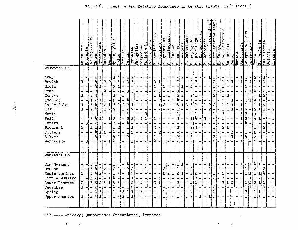
TABLE 6. Presence and Relative Abundance of Aquatic Plants, 1967 (cont.)
1-- _....
I I I
c,., c,., al al OJ OJ
r-i r-i [/)
•rl •rl (I) [/) [/) •rl 'd ~ ~ ::s s ::s •rl [/) [/) [/) s:: al 0 'd
~ •rl (I) [/) g ::s ~ 0 •rl 0 ,.. 0 •rl r-i S::r-i ::s s:: 1i! [/) •rl ,.. ,.. c,., r-i al al
~ <V r-i [/) al 0 0 (I) OJ OJ [/) al s:: 'd [/) .0 Ill •rl (I) al ttl ~ •rl •rl
(I) a! t. OJ ~ •rl ~ c,., ~ s:: 0 (I) [/) ::s •rl s:: 0 ~ s:: ....._. s:: •rl ,..
~ •rl > ~ ,..
•rl a! .g OJ al ~ ,.. ~
•rl •rl s:: s:: s:: [/) [/) •r-i r-i •r-i :- &; OJ ,.. •rl OJ ,.. •rl CJ s:: .g a! OJ
'i s:: OJ 8 (I) ~ •rl <V ttl 0 OJ ~ OJ ,.q .0
~ ~ ::s ttl (I) s:: r-i s:: a! a!
al s:: 0 a! 0 r-i ~ al ~ 'd 0 •rl r-i CJ 1i! 'd -a CJ al CJ .g ~ (I) (I) CJ al ~
G ~ ::s (I) •rl •r-i
,.q <V 1;j al ,.. 'd ttl 0 (I) r-i ~ OJ @ @ ,.. ~ r-i ~ 0 ~ a •rl al 0 s:: >< •rl ~
li CJ •rl c,.,
~ CJ (I) ~ ~ 0 § •rl al OJ -a ~ ~ CJ •rl s:: s:: 0 p::; p::; > ~
~ j ~ •r-i ,.. •rl r-i c,., a! a! ,.. CJ
I~ '2 ~ ~~ ,.. s:: b ~ •r-i ~
,.. al r-i ~
~ ,.. <V a OJ OJ L;g .~ ~ 0 I~ ~
. . . . . . . . . . . . CJ ~ 0 ori I=Q u u A ....:1 ~ p.. p.. p.. p.. p.. p.. p.. p.. p.. p.. p.. p.. p.. p.. p.. p.. p.. p::; p::; C/) C/) C/) 0 > ;:.:: N
Walworth Co.
Army - - - 2 11 - - 11 4 - 2 2 - - - - - - 1 - - - 2 - 1 - - - 1 1 - - - - - 1 1 - 2 - 1 - -Beulah 1 - - 4 2 3 2 4 4 4 3 3 - - - - 3 1 - - - 2 - - 2 3 - - - 2 - 1 2 1 - 1 2 1 1 3 1 - -Booth - - - 4 1 - - 2 1 - - - - - - - 1 - 1 3 - - 1 - 1 - - - - 1 - 1 - - - - 1 - - - - - -Como - - - 3 2 4 - 4 - - 3 3 - - - - 2 3 - - - 3 - - 2 - - - - 3 - - - - - - 2 1 4 - 2 - -Geneva 1 - 2 3 - - - 1 - 1 - - -~- - - 1 1 1 1 - 2 2 - 2 1 - - - 2 - 1 2 - - - - - - 1 2 - -Ivanhoe - - 1 2 1 1 - 2 - - 4 2 - - - - - 2 - - 2 4 - - 1 - - - - 1 - 2 1 1 - - 1 1 4 1 - - -Lauderdale 1 - 3 4 2 2 1 3 1 2 2 1 - 1 - - - 1 2 - - 3 1 3 3 3 - 1 2 2 - 1 1 1 - 1 1 - 1 1 4 - 1 Lulu 1 - 2 4 4 1 - 2 1 1 2 2 - - - - - - - - - 1 - - 1 - 2 - 2 - - 1 1 1 - 1 2 - 2 1 1 - 2 North - - - - 3 - - - - - 4 4 - - 3 - - - - - - 1 - - 1 1 - I - - 1 - 3 - - - 3 3 - 4 - - - -Fell - - 3 4 1 - 1 2 - - 2 2 - 1 1 - 1 - - - - 3 - - 1 4 - 3 - - - 1 - - - 1 2 - 4 1 - - 1 Peters - 3 - 2 2 - - 1 - - 4 4 - - - - - - - - - - - - 2 - - - - - - - - - - - 4 - 1 - - - -Pleasant 2 - 1 1 1 - - 1 2 - 1 1 - - - - 3 3 - - - 2 - - 2 3 - - - 1 - 2 1 - - - - - 1 - 2 - -Potters - - - 4 1 2 - 4 - - 1 2 - - - - - 2 - - - - - - 1 - - - - - - - - 1 - - 1 - 2 - - - -Silver - - - 4 1 - - 4 4 - 2 4 - - - - 1 - - - - 2 - - 2 - - - - 2 - - - 1 - 2 4 - 2 - - - 1 Wandawega - 3 - 1 2 - 1 4 1 - 1 3 - - 2 - 4 - 1 - - 2 - - 2 1 - - - 2 - 1 - - - 1 1 - 2 - - - -
Waukesha Co.
I Big Muskego - - 2 1 - - - 1 1 - 4 4 - - 2 - - - 1 1 - 1 1 - 1 - - - 1 1 - - - - - 1 2 1 4 1 - - -Denoon - - 3 4 2 2 - 2 1 - 2 2 - - 1 - - - 2 - - 1 - - 2 - - - 2 - - - - - - - 1 - 2 - 2 - -Eagle Springs 1 - 1 4 2 - - 1 4 - 3 3 - - - - - - 2 2 1 2 1 - 2 2 - - - 1 - 2 - - - - 1 1 1 1 4 - -Little Muskego 1 - 3 2 - - 1 4 - - - 1 - - - - -,3 - - - - - - 2 3 - - - 2 - 3 - - - 1 1 1 1 - 1 - -Lower Phantom 2 - 3 3 2 4 1 4 3 - 4 2 - 1 - - 3 1 - - - 2 - - 1 1 - - - - - 3 1 1 - - 1 2 2 1 2 - -Pewaukee 1 - - 2 - - - 4 - - 1 2 - - - - - 2 - - - - - - 2 1 - - - 2 - - - - - - 1 1 1 - 1 - 1 Spring - - - 4 3 - - 1 - 2 1 1 - 1 - - - - 1 - - - - - 1 - - - - 1 - - - - - - 3 - 1 1 - - -Upper Phantom 1 - 2 4 1 1 - 1 3 3 1 1 - - - - 1 - 1 - - 1 - 1 2 - 1 - 1 1 - - - - - - 1 - 1 1 3 - -
KEY ---- 4=heavy; 3=moderate; 2=scattered; l=sparse
•
•
•
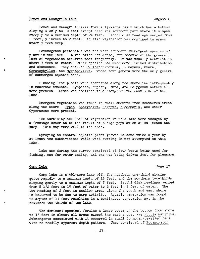
Benet and Shangrila Lake August 2
Benet and Shangrila lakes form a 172-acre basin which has a bottom sloping slowly to 10 feet except near its southern part where it slopes steeply to a maximum. depth of 24 feet. Secchi disk readings varied from 1 foot, 9 inches to 2 feet. Aquatic vegetation was confined to areas under 5 feet deep.
Potamogeton pectinatus was the most abundant submergent species of plant in the lake. It was often not dense, but because of the general lack of vegetation occurred most frequently. It was usually heaviest in about 3 feet of water. Other species had much more limited distribution and abundance. They include P. zosteriformis, P. natans, Chara, Ceratophyllum, and Myriophyllum. These four genera were the only genera of submerged aquatic seen.
Floating leaf plants were scattered along the shoreline infrequently in moderate amounts. N~nphaea, Nuphar, Lemna, and Polygonum natans all were present. Lemna was confined to a slough on the east side of the lake.
Emergent vegetation was found in small amounts from scattered areas along the shore. Typha, Sparganium, Scirpus, Eleocharis, and other Cyperaceae were present.
The turbidity and lack of vegetation in this lake were thought by a frontage owner to be the result of a high population of bullheads and carp. This may very well be the case.
Spraying to control aquatic plant growth is done twice a year by at least two subdivisions while weed cutting is not attempted on this lake.
Lake use during the survey consisted of four boats being used for fishing, one for water skiing, and one wa~ being driven just for pleasure.
Camp Lake June 12
Camp Lake is a 461-acre lake with the northern one-third sloping quite rapidly to a maximum depth of 19 feet, and the southern two-thirds sloping gently to a maximum depth of 7 feet. Secchi disk readings varied from 8 1/2 feet in 15 feet of water to 2 feet in 3 feet of water. The low reading of 2 feet in shallow areas along the south and east shore is believed to be due to carp activity. Aquatic vegetation was found to depth.s of 13 feet resulting in a continuous vegetation mat in the southern two-thirds of the lake.
The dominant species, forming a dense cover on the bottom from shore to 13 feet in almost all areas except the east shore, was Ruppia maritima. Submergents associated with it occurred in small to moderate-sized beds with no readily apparent depth pattern. They consisted of Potamogeton
- 23 -
crispus, P. praelongus, P. natans, Potamogeton spp. (narrow leaf), P. pectinatus, Ceratophyllum, and Chara. Ruppia in places along the southwest shore was dense and close enough to the surface to make it difficult to run the motor through. On the east shore, Myriophyllum was the dominant plant and was choked to the surface in some three-foot areas. Associated with it were Ceratophyllum, Chara, Potamogeton illinoensis, P. crispus, P. amplifolius, P. pectinatus, P. gramineus, Ruppia, Ranunculus, Utricularia and Vallisneria.
Nuphar was the predominant floating leaf plant and occurred in extensive beds with Nymphaea scattered in among it.
Typha angustifolia was abundant along areas of all shorelines with Scirpus validus commonly farther from shore. One small stand of Pontederia cordata was also observed.
Lake use during the survey from 9:30 to 12:00 consisted of one family fishing from shore and one boat being used for fishing.
The president of the Center Lake Sportsmen's Club informed us that three years ago a weed harvester had been used. It was the only known attempt at controlling weeds on the lake. He felt the weed problem on the lake was very great.
Resurvey August 14
Some small changes in vegetation of Camp Lake over a period of 64 days were observed. There was a slight increase noticed in the abundance of Vallisneria, Ruppia, Potamogeton gramineus and Pontederia. Potamogeton crispus and Myriophyllum both appeared to be in poor condition and near the end of their growing season. Potamogeton nodosus, P. robbinsii, Najas flexilis, and N. marina all were found in small quantities and not reported in the first survey. An algae growth on the surface of a Myriophyllum bed near the southe~stern shore was not present during the first survey. I would estimate the weed problem to be about the same as it was during the first survey.
Center Lake August 14
Center Lake is a 129-acre lake which slopes moderately to a maximum depth of 28 feet. Secchi disk readings of 6 and 6.5 feet were recorded. Vegetation was found to a depth of 11 feet.
Najas marina and Chara were the most abundant species of plants recovered from the lake. They were often sparse or dense, and were lacking in a few spots from one to 7 feet. They were most abundant from shore to 4-1/2 feet, although Ceratophyllum in a few instances was also abundant in the area in a few sheltered bays. Small amounts of Potamogeton crispus, Potamogeton spp. (narrow and broad leaf), Anacharis, P. pectinatus, P. natans, Myriophyllum, Vallisneria, and Utricularia
- 24 -
•
were also found from shore to 5 1/2 feet. P. pectinatus and Ceratophyllum were generally sparse and occurred to a depth of 11 feet although it should be mentioned that many of the areas of 5 to 11 feet lacked any vegetation.
Floating leafed plants were well represented. Nymphaea and Nuphar occurred many places along the shoreline and a small amount of Lemna was observed in a bay on the west shore.
TYpha was the main emergent plant on the lake edge. It was esspecially abundant along the western side of the lake. Cyperaceae and Decodon were not extensive in distribution but did occur in dense stands in several small areas. Scirpus validus was more common on the east end of the lake but was not usually dense. Sagittaria was very limited in its abundance and distribution.
In some of the shallow areas Chara and Najas marina were dense and came close enough to the surface to cause a problem for boating. Swimming is carried on at several private beaches which are sand-blanketed and have the weeds raked out. The weed problem is less severe in this lake than in Camp Lake just across the road.
Lake use consisted of three boats being rowed about, four being used for fishing, and two for pleasure motoring, as well as three groups of people swimming.
Cross Lake August 2
Cross Lake is an 87-acre lake which slopes gradually to a maximum depth of 35 feet. Secchi disk reading of 5 feet were recorded. Vegetation extended to a depth of 14 feet.
Chara was the most abundant plant from shore to a depth of 8 feet. Potamogeton was probably the next most common genus present with P. pectinatus, P. illinoensis, Potamogeton spp. (broad leaf) in about that order of importance. Other genera present in this area were Najas marina, N. flexilis, Vallisneria, and Anacharis. From 8 to 14 feet some of the previously mentioned Potamogetons overlapped while P. crispus and P. robbinsii were the only new species of Potamogeton found in this area. Myriophyllum, Ceratophyllum, Najas and Nitella were the most common genera in the 8 to 14 foot area.
Nymphaea and Nuphar were only abundant along the southwest corner of the lake while smaller amounts of both were found along the west side of the lake.
Emergent vegetation consisted of small amounts of Scirpus validus scattered all along the shoreline, small patches of Pontederia cordata along the west and southwest shore, and a stand of TYpha along the southwest corner of the lake.
- 25 -
Pyer Lake August 3
Dyer Lake is a 56-acre lake which slopes gradually to a maximum depth of 13 feet. A secchi disk reading of 6 feet was obtained. Vegetation was recovered from depths up to 8 feet although it may extend farther.
Myriophyllum was the most abundant submergent plant seen in this lake with Chara a close second, especially along the west side of the lake where it was choking at the surface. Ceratophyllum was generally sparse and scattered in shallower areas (shore to 6 feet) and moderately abundant in deeper areas (6 to 8 feet). Potamogeton pectinatus, P. natans, and Potamogeton spp. (narrow and broad leaf) were also found but in rather small amounts.
Both Nymphaea and Nuphar were abundant in this lake, especially along the eastern shore.
Emergent plants were also abundant. Stand of Scirpus validus almost formed a complete band around the lake in shallow water. Also two extensive rypha marshes were present along the northwest and southwest shores.
The vegetation is very dense in areas of less than about 5 feet deep. The only attempts made at controlling the plant is periodic bottom raking. This is done at the Boy Scout camp beach.
The lake was being used for swimming by the scouts at the time of the survey.
Lake Elizabeth August 7
Lake Elizabeth is a 638-acre body of water with a maximum depth of 32 feet. The basin where this depth occurs is in the northeastern part of the lake. Secchi disk readings of 10 and 11 feet were obtained. Vegetation was recovered from a maximum depth of 14 feet.
Chara was probably the most abundant submergent plant in the lake. It occurred from near shore to a depth of about 8 feet. Also moderately common, but not abundant in this depth range were Najas flexilis, Potamogeton pectinatus, P. natans, Potamogeton spp. (broad leaf) and Vallisneria. More widely scattered in the zero to 8-foot area were Najas marina, Myriophyllum, Utricularia, Anacharis, Potamogeton amplifolius, P. gramineus, P. richardsonii, Potamogeton spp. (narrow leaf) and P. zosteriformis.
In areas of.9 to 14 feet which had vegetation, Ruppia, Potamogeton praelongus, and P. robbinsii were most common with the first most abundant.
Floating leaf plants Nymphaea and Nuphar were common along the west and south shore and almost lacking from the north and east shores.
- 26 -
•

f
Emergent vegetation composed of Scirpus, Decodon, Typha and Cyperaceae (sedges) were most abundant in the extreme southern and northwestern parts of the lake but small stands of Scirpus and some Decodon were scattered along the other shorelines.
Weeds do not appear to be a problem in most areas of the lake. The president of a local sportsmen's club stated that the plants present were needed for fish spawning.
Lake use during the survey consisted of 13 boats being used for fishing, 3 for boating and 3 for water skiing.
Lilly Lake July 26
Lilly Lake is an 87-acre lake with a maximum depth of about 6 feet. The water is clear resulting in a secchi disk being visible all over on the bottom when not obscured by aquatic plants. The aquatic plants are very dense in general, and local people complained about the lack of good northern pike fishing in recent years.
The flora of this lake was unusual because a species of Potamogeton (P. amplifolius) was the most abundant plant. It was very often found in dense proportions in water deeper than 5 or 6 feet. Also found in these areas were scattered small amounts of Potamogeton praelongus, Potamogeton pectinatus. Nyriophyllum and Ancharis. From 5 feet to shore, dense areas of Chara, Najas flexilis and Ancharis were common in about that order of importance. Small amounts of MYriophyllum, Potamogeton spp. (narrow leaf), Potamogeton pectinatus and P. nodosus were also common.
Emergent vegetation consisted of small amounts of Typha and Scirpus along the southwestern shore.
A tavern owner complained that many of the fish in the lake, perch in particular, were stunted because the rank growth of vegetation provided too much protection from the northern pike. This could very well be the case because the vegetation, especially P. amplifolius, was very dense in many areas.
Lake use during the survey consisted of 3 people swimming and one person in a boat fishing.
A tavern owner stated that the plants in the lake are mechanically harvested and no spraying has been done.
Narie Lake August 7
Marie Lake is a 315-acre lake with a maximum depth of 33 feet. This deep area is located along a northeast, southwest axis on the eastern side of the lake. The rest of the lake, about half, is less than 10 feet deep. Secchi disk readings of 7 feet were recorded. The maximum depth at which vegetation was recovered was 20 feet.
- 27 -
Emergent aquatic plants were lacking from this lake, maybe as a result of the complete shoreline development.
Floating leaf plants were scarce with only a few small beds of Nymphaea being noticed along the bay shore which is near the outlet to Lake Elizabeth.
Submergent species of aquatic plants were abundant in Marie Lake. The two most abundant plants were Chara and Ruppia. Chara usually occurred from shore to 7 feet, while Ruppia was found from 7 to 17 feet. From 17 to 21 feet, varyingamountsof Nitella were present, or small amounts of Ceratophyllum or Myriophyllum, or in many instances the bottom lacked vegetation from about 19 feet down. In several areas with a depth of about 10 feet there were moderately dense patches of Potamogeton pectinatus. Scattered small amounts of P. zosteriformis, P. crispus, P. praelongus, P. amplifolius, P. robbinsii, P. gramineus, P. natans, Potamogeton spp. (narrow and broad leaf), Vallisneria, Najas flexilis, N. marina, Utricularia, Myriophyllum, and Anacharis were also found from shore to 7 feet with the Chara except along the southeast side. There Chara was the only plant seen. Associated with the Ruppia, Ceratophyllum, and Nitella frequently and in small amounts was Myriophyllum. Less frequently Najas marina, Utricularia, P. robbinsii, P. zosteriformis and Anacharis were found.
Weeds in this lake do not appear to be a very serious problem for boat travel, but may be considered undesirable by the swimmers.
Lake use during the survey consisted of one sailboat, 4 boats being used for water skiing and 4 being used for fishing.
Powers Lake July 19
Powers Lake is a 459-acre lake with an irregular shoreline and a maximum depth of 34 feet. The bottom slopes slowly to rapidly, depending on the area. The water was moderately clear producing secchi disk readings of 9 and 10 feet. One exception to these readings occurred in a bay on the northwest side of the lake. In this area the water was grey in color and produced a secchi disk reading of 2 feet in 3 feet of water. Carp activity may have been the cause of this.
Vegetation was found to depths of 27 feet. Nitella was the only plant found at this depth. It was also the most common plant found in 19 to 27 feet of water. Most areas from zero to 5 feet deep had a light growth of Chara scattered over the sand and gravel. Exceptions to this were usually found in bays where the Chara was generally thicker and a variety of plants were growing with it. Potamogeton pectinatus, P. gramineus, P .. natans, Potamogeton spp. (narrow leaf), and P. praelongus were most commonly seen in these areas and Najas, Myriophyllum, Nymphaea, Nuphar, P. zosteriformis, Scirpus and Vallisneria were less commonly seen. From 5 to 8 feet Chara was usually dense and very often the only plant present. When other plants were found in this depth range, P. pectinatus,
- 28 -
l
1
•
P. natans, and P. gramineus were most common. From 9 to 18 feet, P. praelongus, P. pectinatus, Myriophyllum, and Chara were all abundant. Utricularia, Vallisneria, and Ceratophyllum were less commonly found at this depth range.
Nymphaea and Nuphar comprised the floating leafed plants in the lake. They were confined to small patches in a few bays.
Emergent vegetation was also scarce. Small amounts of Scirpus, Decodon, Sagittaria, TYpha, and Cyperaceae at scattered locations made up the emergents present in the lake.
A man living on the lake for 15 years stated the weeds were worse this year than any other. He said it was the first year they ever had a slimy algae in the shallow water by their dock or small dense patches of Myriophyllum near their dock. This was on the southern part of the east shore. It should be mentioned that this area was the only area where a significant amount of algae was seen. It also was the only area where plants were choking at the surface. The lake had a diverse and generally heavy vegetation mat from 5 to 26 feet. From zero to 5 feet it is generally sparse. The plants were not heavy enough at the surface to impede motorboat travel but swimmers and fishermen may consider the plants a problem.
Use of the lake during the survey consisted of 20 boats out fishing, 6 being used for water skiing and pleasure riding. In addition many people were swimming.
The person contacted did not know of any herbicide spraying or weed harvesting on the lake.
Rock Lake June 8
Rock Lake is a 46-acre lake which quickly grades from shore to a maximum depth of 33 feet. The water is clear giving a secchi disk reading of 14 feet. No vegetation was recovered from depths greater than 16 feet. As a result of the rapidity at which the bottom drops to depths greater than 16 feet, the vegetation is confined to a small portion of the total surface area of the lake.
In general, Chara occurred in a dense mat which completely covered the bottom in most places from zero to 5 feet deep. Also in this area among the Chara were scattered dense stands of Potamogeton crispus, P. natans, Myriophyllum, Anacharis, Nymphaea and Nuphar. Sparse beds of P. praelongus, P. amplifolius, P. zosteriformis and narrow leaf Potamogeton also occurred. In the 5- to 15-foot depths, which were generally less extensive than the zero to 5-foot areas, Ceratophyllum predominated with scattered Myriophyllum and Najas flexilis being observed. Emergents were predominately TYpha associated with Eleocharis, Sagittaria, Juncus, and Carex on the north side. Typha on the south side and TYpha and a sedge on the west side with almost no emergents on the east side of the lake.
- 29 -
The manager of a boat livery was contacted. He stated there was no serious weed problem, although he felt it was silted and congested with weeds at the public access. He plans to dredge and sand blanket the area. He also felt if he could put in another dam board at the outlet it would result in the vegetation being a few inches below the surface instead of at the surface in some areas. My own opinion is that it would not help the situation.
While conducting the two and a half hour vegetation survey, about 10 people were observed swimming just south of the boat livery where a sand blanket had been applied. Five boats were also observed being used for fishing on the lake during this period.
Swimming was restricted to areas which were sand-blanketed because of the dense Chara along shore. Also in a few spots, particularly along the south and east shore, the vegetation formed dense mats which were impossible to move through with a boat and motor.
The lake apparently has had very little herbicide treatment. The livery owner said he tried a small application around the swimming area but he could not remember the name of the herbicide used.
Resurvey August 29
Rock Lake showed very dramatic changes in the distribution and abundance of some aquatic plants between June 8 and August 29, a time span of 83 days. Of the 12 lakes resurveyed, Rock Lake showed by far the most dramatic changes. Three species showed the greatest changes, Pontederia cordata, Vallisneria americana, and Potamogeton spp. (broad leaf). Pontederia cordata was represented by one small stand of about 20 or 30 leaves during the first survey and conservatively over a thousand leaves on the resurvey. The stands were dense along a considerable portion of the southeastern shoreline. Vallisneria and Potamogeton spp. (broad leaf) which were very sparse at the time of the first survey were very common, especially in a depth of about 4 feet during the resurvey, although they were sometimes found in deeper areas from 5 to 7 feet and also sometimes in shallower water. Chara was most prominent towards the deeper water from the Vallisneria and others. Nymphaea and Nuphar were also more abundant, the beds being slightly larger. Not much change was noticed in the abundance of the other plants.
Silver Lake July 18
Silver Lake is a 464-acre lake with a southwest half 10 feet or less in depth and a northeast half slowly to moderately sloping to a maximum depth of 43 feet. Secchi disk readings of '(-1/2 feet were taken at scattered locations.
Vegetation was recovered frcm shore to 15-foot depths, but many large sandy areas from zero to 5 feet lacked any vegetation. Chara was the most abundant plant found in the lake. It was usually sparse be-
- 30 -
•
•

•
tween a depth of zero to 5 feet. Also scattered in this depth range were Potamogeton gramineus, P. pectinatus, P. natans, P. nodosus, Vallisneria, Pontederia, Cyperaceae, Nymphaea, Scirpus, and Nuphar. From a depth of 5 to 8 or 9 feet, Chara was generally dense with small amounts of P. gramineus, P. pectinatus, P. natans, P. crispus, Vallisneria, and Utricularia. From a depth of 8 or 9 feet Chara was almost lacking with the most abundant plants being P. pectinatus, Najas marina, and Nitella. Nitella was dense only in the 15-foot areas. Plants of less abundance in this area included Myriophyllum, Ceratophyllum, Vallisneria and Utricularia.
At the time of the survey, no plants were choking at the surface.
Although Chara was dense in many places it did not grow far off the bottom so it did not appear to be a problem. In depths of 8 to 12 feet where P. pectinatus appears, a plant problem may exist. P. pectinatus almost reaches the surface in these areas and may interfere with swimming and fishing. It should be stressed however that at present, the area of the lake with plants near the surface is small.
A former head of the local sportsmen's club informed us that a boat livery owner was cutting weeds just off his livery and this was the only cutting being done on the lake. He further stated that there has been no herbicide spraying done on the lake.
Lakes of Racine County
Bohners Lake July 26
Bohners Lake is a 124-acre body of water with a bottom that increases in slope to a depth of 25 feet. The maximum depth is 30 feet. A secchi disk reading of 8 feet was obtained. Vegetation was found at a maximum depth of 17 feet.
Chara was the most abundant submerged aquatic plant found in the lake occurring from shore to about 7 feet. It was usually dense from 2 to 5 feet and sparser in the remainder of the areas in which it occurred. Only one sizable shallow water area of the lake lacked Chara. This was an area about one-third the length of the west shore near the southern part of that shore. In that area Najas flexilis, Potamogeton gramineus, Myriophyllum and Ceratophyllum were common. Also found in scattered locations in a depth of 1 to 7 feet were: Anacharis and Potamogeton natans primarily along the south shore; Potamogeto~ gramineus and Utricularia along all shorelines; and small infrequent amounts of P. zosteriformis and Vallisneria along all shores. In deeper water areas from 8 to 17 feet, Nitella, Ceratophyllum and Najas flexilis were the most abundant plants, with small amounts of the previously mentioned plants also present.
No noticeable amounts of floating leaf or emergent plants were present.
- 31 -

Lake use during the survey consisted of 4 boats being used for pleasure riding and 2 being used for fishing.
Browns Lake July 12
Browns Lake is a 396-acre lake with about 70 percent of its area less than 12 feet deep. On the east side there is a small area which slopes sharply to a maximum depth of 44 feet, and in the north central area depths range up to 18 feet. Secchi disk readings varied from 3-1/2 feet in shallow water (5 feet deep) to 5 feet in 11 and 18 feet of water. The water appeared brownish and visibility was poor.
Vegetation was found from shore to depths of 13 feet. Chara was the most abundant plant in the southwest bay. It covered the bottom usually in a dense mat. Ruppia, Myriophyllum, Potamogeton pectinatus, and~ crispus were associated with it in small quantities near shore. The rest of the lake was dominated by Ruppia maritima. It was almost without exception the only plant found in depth greater than 6-1/2 feet and less than 13 feet. It also occurred in patches from 6-1/2 feet to shore with Chara and small scattered amounts of Potamogeton pectinatus, Potamogeton spp. (narrow leaf), P. crispus, and Myriophyllum. In 9 to 12 feet of water, Ruppia formed dense patches with hundreds of its silk-like flower stalks streaming for about a foot on the surface. Because of the extreme density of the plants there appears to be a weed problem on this lake.
Public use of the lake during the survey consisted of 4 fishing boats, 1 waterskier, and 20 swimmers and sunbathers divided between three beaches.
Lake Buena July 21
Lake Buena is actually a 241-acre section of the Fox River just south of Lake Tichigan. It has a maximum depth of 8 feet in the channel. A secchi disk reading of 2 feet was recorded form the channel area although the water was clear enough to see the bottom at a depth of 4 feet in the center of the west bay.
Vegetation was found to the maximum depth of 8 feet. In the center of the channel, where the water was generally deeper, Ceratophyllum occurred in sparse amounts. Small amounts of Lemna and Wolffia were also observed scattered on the surface in some spots in this area. Along the shoreline of the channel and bays in from slightly to well sheltered areas Ceratophyllum was usually choking at the surface and covered by a mat of Lemna and Wolffia and/or algae. Along the channel shoreline Lemna and Wolffia were.the main plants covering the Ceratophyllum while algae was more abundant in the bays. The algae which was largely Cladophora usually had moderate amounts of Lemna and Wolffia on it. Nymphaea and Nuphar were also found in considerable amounts in the large western bay as well as several bays and back waters. Small scattered amounts of Potamogeton pectinatus, Potamogeton spp. (narrow leaf), P. robbinsii and Chara were also found in the lake.
- 32 -

Several large marshes and small islands provided habitat for emergent vegetation along the lake shore. Decodon and Typha were the two main emergents with smaller amounts of Sparganium and sedges also occurring. Decodon when associated with TYpha was found usually in a narrow band of less than 10 feet wide along the edge with large areas of Typha shoreward from it.
This lake has a serious problem in most areas except for the channel proper. The water was shallow and the Ceratophyllum so dense that many areas were almost impossible to get through by rowing or motoring. The large amounts of Lerona, Wolffia and algae all add appreciably to the problem.
Attempts to combat the weeds were being made by a vegetation harvester. A marina owner had no knowledge of herbicide spraying on the lake.
Lake use consisted of 4 boats being used for fishing, 3 for water skiing, and 1 for pleasure riding. Water skiing and pleasure riding were restricted to the channel.
Eagle Lake June 12
Eagle Lake is a 520-acre lake which gradually slopes to a maximum depth of 15 feet. The water in this lake is turbid, producing secchi disk readings of 6 inches to a foot in 3 feet of water along the eastern shore, 2-1/4 feet in 5 feet of water along the west shore, and 1-1/2 feet in 7 feet of water along the south shore. The water level appeared to be higher than normal in the lake. Many docks were just at the water level or partly submerged.
Submergent vegetation in this lake was very sparse. No vegetation was recovered from depths greater than 4 feet. Chara and Cladophora were the main plants, occurring from shore to a depth of 4 feet. When occurring singly or together, they were sparse and not at all healthy looking. Potamogeton crispus, Potamogeton spp. (narrow leaf) and Vallisneria complete the list of submergents recovered. They each occurred only sparsely.
Resurvey August 29
Several changes were noticed in the abundance and distribution of some of the aquatic plants in the lake over a time lapse of 80 days. One of the most striking changes was the appearance of dense patches of Vallisneria along the shoreline in many places. One spot in particular which upon sampling the first time produced only a sparse amount of Vallisneria, produced upon resurveying a dense bed about 125 feet long and 20 feet wide. A small amount of Najas flexilis was observed along the southwest shoreline. It was previously not recorded in the lake. At scattered areas along the shore large patches of bluegreen filamentous algae were seen. The other plants seen in small amounts during the first survey were about the same.
- 33 -

Carp probably play an important role in limiting plant life in this lake by uprooting it and making the water turbid. At the time of the survey a great deal of carp activity was noticed along the western shore. The turbidity was less than during the first survey.
Keenong Go Mong August 15
Keenong Go Mong is a 97-acre lake which generally slopes rapidly to a maximum depth of 26 feet. Secchi disk readings were not taken in this lake, but a 5- or 6-foot reading would probably have been obtained. The maximum depth sampled was 10 feet. Vegetation was recovered from this depth and may have occurred in deeper water also.
Of the submergent species of plants, Chara and Naja~ marina were both very abundant. They occurred in dense patches all along the shoreline in a depth of 1 to 5 or 6 feet except along the northeastern shore where the bottom was hard and sandy. In that area, only Scirpus validus was seen. Myriophyllum and Ceratophyllum were abundant from a depth of 6 to 10 feet and generally sparse from 1 to 5 feet. One exception to this general distribution is worthy of mention. Ceratophyllum formed a dense bed near shore and in some areas of the circular canal, both at the south end of the lake. Potamogeton pectinatus was sparse but common in occurrence while P. natans, P. gramineus, Potamogeton spp. (broad leaf), Najas flexilis, Polygonum natans, and Utricularia were more sporadically distributed.
Nymphaea and Nuphar were moderately abundant in the lake. They were present in greatest numbers along the northwestern shoreline.
Emergent vegetation was well represented along the lake shore. Scirpus validus was the most common species. It was heaviest along the north, east and south shore. Along the northern two-thirds of the western shoreline Spartina and Cyperaceae (sedges) were most abundant. Small amounts of Typha, Sparganium, Rumex, and Sagittaria were also present.
The small area of the lake under a depth of 4 feet has sufficient vegetation in most places to make using a boat with a motor very difficult. Swimming in the lake is also hampered by the vegetation but people with sand-blanketed shorelines rake out the plants and do maintain swimming areas.
A lake lot owner stated that as far as she knew, the vegetation had not been sprayed or cut for 10 years, at which time they had to pay $80 towards spraying the shoreline.
Lake use during the survey consisted of 3 boats being used for fishing.
Long Lake July 25
Long Lake is a shallow 124-acre lake with a maximum depth of 8 feet. A secchi disk in a depth of 8 feet produced a reading of 4 feet. The
- 34 -

small 8-foot deep area is located at the southwestern end of the lake. At the northeast end is a somewhat larger area with a maximum depth of 4.8 feet. However, the majority of the lake is less than 3 feet deep with many areas near the north end of the lake too shallow to allow boat travel. In this area the narrow, shallow channel through the Scirpus made it impossible to reach the deeper area at the north end of the lake. As a result this area has not been included in the vegetation survey.
Scirpus was the most conspicuous plant in the lake. It occurred in dense stands especially large towards the northern part where it completely covered the lake except for a channel and small open areas. It was present all along the shoreline except for a small area on the extreme southwestern, northwestern, and possibly the northern shoreline. The channel through the center of the Scirpus lacked vegetation except for a few small beds of Nuphar. Small to moderate stands of Cyperaceae (sedges), ±7Pha, Sagittaria, and Decodon also occurred but contributed little to the bulk of Scirpus. The southern and central part of the lake contained less Scirpus with large amounts of the bottom covered by Najas marina and small amounts of Najas flexilis, Potamogeton spp. (broad leaf), P. illinoensis, P. nodosus, P. pectinatus and Utricularia. Floating leaf plants were also common in the southern part of the lake with Nymphaea and Nuphar in about equal numbers--Nymphaea being more common in the extreme southwestern part of the lake and Nuphar being more common in the south and south central parts of the lake. A cottage owner stated that he has seen Utricularia very dense in the central areas in some years. He also stated that Lemna is sometimes abundant along shore. During the survey, Lemna was not observed and Utricularia was sparse.
The main plant problem is due to the large amount of emergent Scirpus. Because of the shallowness of the lake this problem will probably presist. No herbicide spraying or weed harvesting are being done on the lake.
During the survey one boat was being used for fishing on the lake. There was also a large number of duck blinds in the Scirpus areas indicating the use of the lake for duck hunting during the fall.
Lake Tichigan June 16
Lake Tichigan is an 891-acre lake with a northeast half sloping moderately to 10 feet then rapidly to a maximum depth of 63 feet, and a shallow southwest half which maintains a depth of about 4 feet. Secchi disk readings in the deep half of the lake ranged from 9 feet in 25 feet of water to 2 feet in the northern most bay. The 2-foot reading was attributed to large amounts of a colonial, nonfilamentous, green algae which was very abundant in the lake. The water in the southwest half of the lake was turbid, producing readings from 1 foot to 1.5 feet. The bottom was muck on the southwest half of the lake.
Because of the differences in clarity depth and vegetation this lake will be considered in two parts. The northeast half had vegetation restricted to depths of 8 feet or less which resulted in a small portion of
- 35 -
the area with rooted aquatic plants. The most abundant species was Potamogeton crispus. It formed a fairly continuous band along the shoreline in from 3 to 8 feet of water but was most often not dense. Ceratophyllum and narrow-leafed Potamogeton were often found associated with it usually in shallow water (0 to 5 feet). In the northern most bay, Myriophyllum was associated with P. crispus, both occurred in dense proportions in large patches. P. pectinatus was observed in two locations in sparse amounts.
The northern half of the lake lacked emergents except for the northernmost shore where TYpha and Decodon were abundant and Solanum occurred sparsely.
Floating leaf species were also not abundant; one bed of Nuphar on the west shore and one of Nymphaea on the east shore were the only beds of water lilies observed. Lemna occurred sparsely at the shoreline in several spots.
A free-floating nonfilamentous, colonial green algae Planktospheria was abundant as spherical masses about the size of a dime over deep water areas and formed a floating mass blanketing the water just off shore.
The southwestern half of the lake was dominated by Ceratophyllum. It was generally sparse in offshore areas and moderate to choking at the surface near shore. Some areas of choking Ceratophyllum occurred around the island near the south shore and along the northern shore of the south half of the lake. Around the island the Ceratophyllum looked yellow because of the large amount of Lemna and algae on its surface. Small amounts of P. crispus, P. praelongus, narrow leaf Potamogeton, ~ pectinatus, and Myriophyllum were found in the near shore areas associated with Ceratophyllum.
Floating leaf plants include large beds of Nymphaea and Nuphar. Lemna also was found commonly along the shoreline, usually in small amounts but sometimes dense.
A great deal of the shoreline on this half of the lake produced emergent vegetation which was dominated by TYpha with Scirpus, Decodon, Phragmites, Solanum, and SparBanium also represented.
Use of the lake during the survey consisted of 7 boats for fishing, 3 pleasure riding and 3 groups swimming.
Two landowners were contacted with regard to weed problems and control. They both complained about the high carp population and algae bloom in the lake. One owner stated he no longer let his grandchildren swim off his dock because they used to come out of the water with a coat of algae on themselves. Neither landowner knew of spraying or harvesting of weeds on the lake.
- 36 -
•
Resurvey August 30
Several changes occurred in the distribution and abundance of aquatic plants in Lake Tichigan between June 16 and August 30, a span of 76 days. In the northeast half of the lake where Potamogeton cris1us occurred at a depth of 3 to 8 feet and Potamogeton spp. (narrow leaf and Ceratophyllum occurred in small amounts from shore to 5 feet, no vegetation, except for very sparse amounts of Ceratophyllum, was raked up upon resurveying. This was also true of the northern bay where dense Myriophyllum occurred before. Because of the vegetation still present in other lakes, some methoda of removing the vegetation was apparently employed in this lake, most likely herbicide spraying.
In the rest of the lake most noticeable was the increase in Ceratophyllum almost continuously along the shoreline averaging in width from a few feet to about 15 feet. Also an increase in the amount of Lemna was noticeable. It was almost restricted in its distribution to shoreline areas and places where Ceratophyllum reached the surface. It often corresponded very nicely to the maximum extent of dense Ceratophylum beds. The Ceratophyllum away from the shoreline which was sparse before, was even sparser. Another difference noticed was several areas of ~ nodosus not observed during the first survey. Decodon, because of the little early growth, was very much underrated during the first survey. It was discovered on the second survey that it plays a prominent role in the emergent vegetation. It is second only to the very abundant Typha.
Lake Waubeesee June 27
Lake Waubeesee is an exceptionally clear 129-acre lake producing secchi disk readings from 17 to 18 feet. The lake slopes gradually to a depth of about 6-1/2 feet and then steeply to a maximum depth of 73 feet. Vegetation was recovered from depths up to 20 feet.
Chara was by far the most abundant plant in the lake. It was recovered from shore to depths of 9 feet and was generally dense, forming a complete bottom cover except for the southeast side of the lake and the areas very near shore. Most commonly associated with it near shore were P. pectinatus, Potamogeton spp. (narrow leaf) and P. praelongus. Less commonly occurring were Anacharis, Myriophyllum, P. amplifolius, P. crispus, Ranunculus, and Vallisneria. From about 14 to 20 feet Nitella occurred in dense patches.
Floating leaf plants consisted of beds of Nymphaea and Nuphar with Nymphaea being more common.
Emergent vegetation was dominated by Typha and Scirpus with Decodon, Rumex and Sparganium making up a minor part of the vegetation.
Lake use consisted of about 25 people swimming at a resort and one boat out fishing.
The weed problem does not appear serious at this lake. At no place on the lake was the vegetation dense at the surface. The Chara was dense but did not extend far off the bottom.
- 37 -
Resurvey August 16
The major vegetation on this lake showed no noticeable changes in abundance or distribution, although there were some changes in the status of a few less common species. Small amounts of Potamogeton spp. (broad leaf) were observed in the second survey but not the first. A small dense patch of Ranunculus had been reduced to a small scattered amount on the west side of the lake. P. crispus was also less abundant along the northern shoreline. The only other noticeable changes were a small increase in the amount of Vallisneria on the lake.
Wind Lake June 13
Wind Lake is a 936-acre lake with a shallow northeast half gradually sloping to a depth of slightly more than 15 feet and a deep southwest half sloping more rapidly to a maximum depth of 47 feet. Secchi disk readings ranged from 6 inches in 2 feet of water to 4 feet in 15 feet of water on the northeast half and 8.5 feet in 12 feet of water on the southwest half of the lake. The vegetation ranged from shore to about 10 feet of depth.
Chara was the dominant plant but large areas from 0 to 10 feet were completely lacking vegetation. The Chara was often patchy and thinly covered the bottom when it occurred. MYriophyllum was the second most common plant encountered. It was most often sparse when found. Exceptions to this were the 8-foot areas of the northeast half of the lake where it was dense. Narrow-leafed Potamogeton was also observed often in 0 to 10-foot depth, although never very abundantly. P. illinoensis and P. praelongus were less common but did occur in small beds in scattered locations. Ceratophyllum was also found at scattered locations with a significant concentration between shore and the island on the west side of the lake. P. natans, P. crispus, Anacharis, and Vallisneria complete the list of submerged aquatics observed. They were either found once or rarely, and probably do not contribute significantly to the flora.
Scirpus validus, S. americanus and Typha comprise the greatest proportion of emergent aquatic vegetation. Typha usually occupied the lake edge areas and sandbar in dense stands while Scirpus was farther off shore. Scirpus was observed to have a dark brown cast, from a distance, while Typha appeared green. Sparganium and sedges made up a minor part of the emergent vegetation.
Floating leafed plants were not very abundant on this lake. Nymphaea was more common than Nuphar- with a large bed occurring between the island and shore.
Public use of the lake during the survey consisted of about 20 boats on the lake. One was being used for water skiing and the rest for fishing. No one was observed swimming.
A cottage owner was contacted with regard to weed problems and control. He lived in about the center of the north side of the lake and stated that a lot of plant matter drifted into the shallow water by his
- 38 -
dock and was a nuisance. He knew of no spraying or weed harvesting occurring on the lake.
In many of the shallow water areas there was vegetation, but at the time of the survey, it was not dense enough to hamper motor travel, although it was undesirable for swimming.
Resurvey August 16
Several evident changes took place in the abundance of some species of plants in this lake between June 13 and August 16. Vallisneria increased in abundance especially along the north shore. Here Anacharis, P. illinoensis, and P. richardsonii also increased, but to a lesser degree. Between the island and shore on the west side of the lake, Najas marina was not seen during the first survey but it formed a large dense bed at the time of the resurvey. Small amounts of this plant began to appear in lakes about July 15 and has been found in many since that date. The last lake it was found in was Center Lake on August 14 where it was very abundant. This plant may get a slow start in summer and only reach its peak in mid-August. The stands of Scirpus americanus had also inc~eased in size enough to be noticeable. Scirpus validus and Chara probably also increased, but slightly.
Lakes of Walworth County
Army Lake August 28
Army Lake is a 78-acre body of water with a bottom which slopes slowly to a maximum depth of 17 feet. A secchi disk reading of 8 feet, 7 inches was recorded. The maximum depth vegetation occurred at was 13-1/2 feet.
The most abundant species of submergent aquatic plant found in the lake was Najas marina. It occurred from very near shore to the maximum extent of vegetation. Except for very small amounts of Potamogeton pectinatus and Myriophyllum, it was the only plant found at a depth of greater than 8 feet. In some places on about the 7-foot contour, higher concentrations of P. pectinatus were seen. From 5 feet to shore in many areas vegetation was lacking. The small bay areas generally had larger accumulations of plants with Chara and Najas marina common and Potamogeton nodosus, P. pectinatus, P. gramineus, Potamogeton spp. (narrow leaf), Najas flexilis and Vallisneria less common in about that order of importance.
Nymphaea and Nupha~ beds were not extensive but did occur in most of the small bays.
Emergent vegetation was restricted to the north and northwestern sides of the lake. The north side of the lake had several small stands of Scirpus while the northwestern side had an extensive marsh. The marsh near the lake edge was composed largely of TYpha with scattered ~ttaria and Scirpus.
- 39 -
Weeds do not appear to be a serious problem for the lake in general but some b~ areas do have very dense plant life.
Lake use during the survey consisted of 4 boats being used for fishing and two people swimming.
Lake Beulah June 20
Lake Beulah is a 837-acre lake which slopes, rapidly in some areas and slowly in others, to a maximum depth of 58 feet. The lake is exceptionally clear producing secchi disk reading from 9 to 14 feet. Vegetation was found from shore to depths of 30 feet.
The lake has a wide variety of abundant species of plants which were found from 15 feet of water to shore. Of the 27 genera thus far recorded, 19 were also found in Lake Beulah. The only generalization which would hold true for the entire lake is that Nitella was the only plant found in 25 to 30 feet of water. It usually graded into Najas flexilis and then Chara or directly into Chara or Myriophyllum. MYriophyllum was very abundant in the southwest half of the lake. In general the lake bottom sloped very steeply from 10 to 30 feet resulting in difficulty in obtaining samples from that depth. The majority of the bottom between 10 feet and shore was covered by Najas and Chara in about equal amounts. They were generally very dense mats. MYriophyllum covered extensive areas in the southwestern part of the lake. Large dense to small sparse beds of Potamogeton amplifolius, P. praelongus, Potamogeton spp. (narrow leaf), P. pectinatus, P. natans and Anacharis were very common in all areas of the lake between shore and 10 or 12 feet. Utricularia was never abundant at one spot but was often found, especially with Ch~. Ranunculus was moderately abundant in several of the shallow b~s of the lake. Potamogeton crispus was choking in one very small bay. This was the only place it was observed except for a few plants along the south shore. Vallisneria, P. zosteriformis and P. crispus were the only submerged aquatics found that were not common.
Emergents consisted of Typha, Decodon, members of the family Cyperaceae, Sagittaria, Sparganium, Rumex, and Scirpus in about that order of abundance.
Floating leafed plants were found mainly in sheltered bays and consisted of large beds of both Nymphaea and Nuphar. Lemna was also present although only once in real dense proportions.
Lake use during the survey consisted of several groups swimming, 6 boats being used for pleasure riding, 10 boats for fishing, and 10 sailboats.
A landowner was contacted in regard to weed problems and control measures. He stated the lake was slowly going downhill with regard to the weeds. He said he had, in the past been able to swim across the bay near his home without feeling weeds, but not now. He did not know of any herbicide applications on the lake. A weed harvester was observed on the northeast side of the lake during the survey period.
- 40 -
..

From 0 to 10 feet there was almost a continuous plant cover. It did not generally reach the surface except in some areas of the southwestern half of the lake where Myriophyllum, the chief plant, was choking at the surface. Chara was also quite near the surface in some 0 to 2-foot areas.
Resurvey August 24
Several changes in the distribution and abundance of aquatic plants were observed in this lake from June 19 to August 24, a time lapse of 56 d~s. The most dramatic change noticed was the increase in abundance of Najas flexilis. Vallisneria also appeared to have increased in abundance since the first survey but not nearly to the extent of Najas flexilis. The only other species which showed any noticeable increase was Myriophyllum although it was only slight. Several species had also decreased. They were Potamogeton crispus, P. praelongus, Potamogeton spp. (narrow leaf) and Ranunculus. Three secchi disk readings were taken, two were lower than the previous readings and one was higher. They averaged 10 feet. The previous average was 12.25 feet.
Booth Lake July 21
Booth Lake is a 113-acre lake which slopes gently to a maximum depth of 24 feet. The water was clear and produced a secchi disk reading of 13 feet.
Vegetation was found from shore to a maximum depth of 14 feet. Myriophyllum, Najas, Potamofeton gramineus, and possibly Chara were found in small amounts at 1 feet. There was some doubt that Chara was growing at this depth. It may have drifted there.
The west side of the lake had a diversity of plants while the rest of the lake was strongly dominated by Chara. It was generally sparse on the southeast side of the lake and dense on the northeast and west sides of the lake. On the west side of the lake Myriophyllum often was found in heavy proportions especially in depths of 8 to 10 feet. From a depth of 10 feet to shore, Najas, P. gramineus, and P. illinoensis were common in small beds. P. nodosus, P. zosteriformis, Potamogeton spp. (narrow leaf), P. pectinatus, and P. amplifolius were also present but less common. Along the other shore only small scattered amounts of ~ gramineus, Najas flexilis, N. marina, P. illinoensis, and Myriophyllum were observed.
Vegetation is most abundant on the west shore and while it was not dense enough to impede motorboat travel, it may be a problem for swimmers and fishermen. The Chara as in other lakes usually extended for less than a foot off the bottom so although dense, it seldom reached near the surface.
Floating leaf plants were completely lacking on the lake and emergents consisted of small stands of Carex and Scirpus.
Lake use during the survey consisted of one sailboat in operation and four people swimming.
- 41 -

Lake Como June 22
Lake Como is a 946-acre lake which slopes gently to a maximum depth of 9 feet. This lake is turbid, producing secchi disk readings from 9 inches to one foot. A cottage owner stated four years ago the water was clear and the bottom could be seen all over the lake. He believes the turbidity has been caused by the large bullhead population which has developed in recent years. No vegetation was found at depths greater than 6-l/2 feet.
The predominant species of submergent plant in the west half of the lake was Potamogeton crispus. It was sparse along the south shore of the west half, with considerable areas completely lacking vegetation. Myriophyllum and narrow leaf Potamogeton were associated with it on that shore but very sparsely. On the north shore of the west half P. crispus was more abundant and choking at the surface over a large area. A few large beds of P. amplifolius and scattered Myriophyllum, Nuphar, narrow leaf Potamogeton were associated with it on the north side. The west end of the lake was composed of a large TYpha marsh with considerable areas of Decodon, Nymphaea, Nupha~, Myriophyllum, P. crispus, and small amounts of P. natans and P. amplifolius. The north shore eastward grades into a large TYPha and Decodon marsh with Nymphaea and Nuphar present off shore. Chara was off shore from the marsh. It was often abundant with scatter----ed narrow leaf Potamogeton and P. pectinatus. The east shore was domi-nated by Chara and Myriophyllum with considerable amounts of P. pectinatus, P. natans, and lesser amounts of P. nodosus. ~~. Scirpus, Cyperaceae, and Decodon comprised the emergents and ~aea and Nuphar the floating leaf plants. The south shore of the east half was composed of a large Typha marsh with some Scirpus, Cyperaceae, and Decod~n along the edge. Cha~, Myriophyllum, P. natans, narrow leaf Potamogeton, ~phaea, and Nuphar complete the list of species found off shore from the marsh.
Lake use during the survey consisted of 2 groups fishing from shore, 3 from boats, and l water skiing and 1 swimmer.
A livery owner and a cottage owner were contacted in regard to plant control. Neither knew of any weed spraying on the lake. They both stated a subdivision on the north central shore used a weed cutter. This area of the lake has the worst weed problem with the east and west ends a close second.
Resurvey August 29
Several changes in the distribution and abundance of aquatic plants were observed in this lake from June 22 to August 29, a time lapse of 69 days. The most striking change noticed was the almost total disappearance of Potamogeton crispus along the north shoreline of the western half of the lake. It had been very dense in some places in the area during the first survey. Another difference was an apparent increase in the amount of Myriophyllum. The Myriophyllum beds were very dark in color though, and may have appeared more abundant because they were more conspicuous. During the first survey the Myriophyllum did not protrude above the surface as in the resurvey. The only other difference notic-
- 42 -

ed was an apparent increase in the Nymphaea and Nuphar beds along the southeast shore and a decrease in the amount of Potamogeton amplifolius along the northwest side of the lake. The far west and southwest sides of the lake were not resurveyed because of a storm which forced us off the lake.
Lake Geneva July 5, 6 & 7
Lake Geneva is a clear 5,262-acre lake which generally grades steeply to a maximum depth of 135 feet. Secchi disk readings ranged from 13 to 14 feet. Vegetation was found in depths up to 26 feet. Chara, Nitella, and Ceratophyllum were the only plants found to that depth.
Chara was the most common plant in the lake but it was not dense, except for a few locations. It occurred most often sparsely from zero to 26 feet. In the deeper areas Anacharis was sometimes found with it. Often the Chara was replaced in deeper water by Ceratophyllum or Nitella. Commonly attached to the rocks, extending from the shoreline sometimes to 16 feet of water, was a sparse to dense mat of Cladophora, or (once) Spirogyra. Small amounts of Vallisneria were commonly found in depths of 1 to 6 feet of water. Ranunculus was found slightly less regularly, usually in about 10 feet of water. From 4 to 10 feet of water at scattered locations small amounts of P. pectinatus, Potamogeton spp. (narrow leaf) Myriophyllum, P. amplifolius, P. crispus, P. gramineus, ~ illinoensis, P. natans, P. nodosus, P. praelongus, P. zosteriformis, and Utricularia were found.
The shoreline was completely developed and lacked both emergent and floating leafed vegetation.
Lake use during the survey consisted of many boats fishing, sailing, pleasure riding, and water skiing. The lake also has a reputation for swimmers and sun bathers.
One owner contacted knew of no herbicide spraying or vegetation harvesting on the lake.
One person contacted felt the weeds were about at their peak. If that was the case, I feel the plants were too sparse to be considered a problem.
Ivanhoe Lake June 29
Ivanhoe is a 41-acre lake which slopes gently to a maximum depth of 11 feet. In 9 feet of water a secchi disk reading of 6 feet was obtained.
Vegetation was recovered from shore to a maximum depth of 11 feet, although many of the deeper areas sampled lacked rooted plant life. Small amounts of MYriophyllum, Ceratophyllum and Potamogeton crispus were the only plants found from depths of 6 to 11 feet. From a depth of 5 feet to shore there were large Nuphar and Nymphaea beds with the former much more abundant than the latter. Also in this area scattered
- 43 -
abundantly in small to moderate sized beds were P. natans, Myriophyllum, P. crispus, P. lucens, P. zosteriformis, and Chara. Also found in small amounts were P. pectinatus, Potamogeton spp. (narrow leaf), Ranunculus, and Utricularia.
Emergent vegetation was abundant along the margins of this lake which had almost no shoreline development. A Typha marsh almost completely surrounded the lake with some small stands of Decodon, members of the family Cyperaceae and a few individual Rumex plants near the water. In the water along shore small stands of Scirpus were present.
Along the northeast and southwest shores the plants were dense enough to make motorboat travel difficult. The rest of the shoreline had less dense vegetation although a considerable amount was present.
Lake use during the survey consisted of one person in a boat fishing.
Resurvey August 29
Very little change was noticed in the distribution and abundance of aquatic plants in this lake over a time lapse of 61 days. Chara appeared to be slightly more abundant along the east shore during the resurvey. Myriophyllum appeared to be slightly more abundant along the southwest shore. And finally, Potamogeton crispus appeared to be less abundant and lacking from some areas it occurred in during the first survey.
Lauderdale Chain of Lakes August 10, 11
Lauderdale Chain of Lakes forms a 841-acre area of water in three major basins. The slope of the bottom is gradual up to about 10 feet at which point it becomes quite steep to a depth greater than 40 feet in each basin. Secchi disk readings in these basins varied from 13 to 16 feet. The maximum depth at which vegetation was found was about 23 feet.
The aquatic plant life of this chain of three lakes is very diverse generically. Of the 33 genera of aquatic plants thus far recorded, at least 23 of them were present in the chain. Like Lake Beulah, the vegetation was difficult to map because the species composition was constantly changing. This is especially true in areas that surrounded the deep part of the lakes. The bays in general had more extensive areas over which little change in species composition took place. Of the submer~ gent plant life that surrounded the deep basins, Vallisneria and Chara were most abundant forming small dense to moderately sparse beds. Vallisneria was often dense but also often sparse, mixed with Chara or other species while Chara was usually dense with only small amounts of other plants growing over it. Potamogeton natans, P. oakesianus, ~ praelongus, P. pectinatus, and Myriophyllum were frequently found in smaller amounts mixed in with the Chara and Vallisneria. In the deeper areas (10 to 23 feet) Nitella, Ceratophyllum, Myriophyllum, and~ pectinatus were most common. The 10- to 23-foot area was usually small in extent because of the fast rate at which the depth changed after 10 feet. The submergent plants that were not common but seen from time to
- 44 -

1
time were P. zosteriformis, P. crispus, P. gramineus, P. robbinsii, Utricularia, Ranunculus, Polygonum natans, Najas flexilis, and Anacharis. In the large shallower bay areas not surrounding deeper areas, the most abundant submergent species were Ceratophyllum, Myriophyllum, and Chara. It should be mentioned though, that large parts of these areas lacked vegetation completely or had only floating leaf or emergent plants on them. Many of the other plants already mentioned also were found in these bay areas but in lesser numbers. P. nodosus and Najas marina were two plants found in bay areas which were almost entirely lacking from the areas around the deeper parts of the lakes.
Nymphaea and Nuphar were most abundant in the large bays but were also found along the general shoreline. Small amounts of Lerona were also seen.
Emergent plants were also much more abundant in the large bay areas. Some large dense stands of Typha, members of the family Cyperaceae, Scirpus and Zizania were observed as well as small amounts of Sagittaria, Rumex, Decodon, and Eleocharis.
A weed problem does exist in some of the shallower areas of the lakes. The dense Ceratophyllum, Nymphaea or Nuphar in some spots make motorboat travel almost impossible. In the areas around deep basins the vegetation quickly disappears because of the depth.
Lake use during the survey consisted of many boats being used for fishing, pleasure riding, and water skiing. There were also several diving boards and many rafts for swimming but little swimming was seen because of cool weather.
Weed spraying and mechanical harvesting are being done on this lake according to the local building inspector.
Lulu Lake August 8
Lulu Lake is a clear 84-acre lake which has a bottom that slopes with great rapidity from a depth of 5 feet to 25 feet and gradually to the maximum depth of 40 feet. The area of 5 feet or less in depth varies from about 10 feet to 40 feet in width. Secchi disk readings were 13 and 16 feet. Nineteen feet was the deepest area from which aquatic vegetation was recovered.
The submergent plant distribution in this lake was moderately simple. Chara was the predominant plant and covered the bottom in most areas under 5 feet deep. In the shallow areas Chara was choking at the surface in spots making boat traffic impossible. The only areas within this depth where Chara was not dense occurred along the west central and southern shores. The west central shore was dominated by Myriophyllum with one spot of dense Anacharis. The ·southern shore had some dense patches of Naj as . flexilis arid some bare sand areas as well as Char a, P. richardsonii, and P. natans in small amounts all along the shoreline. P. zosteriformis, Anacharis, P. pectinatus, Vallisneria, Utricularia and Potamogeton spp.
- 45 -
(broad leaf) were much less frequently seen and when seen were in small amounts. In the limited area from 6 to 19 feet, small to moderate amounts of Nitella, Najas flexilis, Ceratophyllum, Vallisneria and P. pectinatus were found.
Nymphaea and Nuphar were common along the shoreline often in moderate sized beds.
Emergent plants of the family Cyperaceae were abundant along the shoreline. Lesser amounts of Scirpus, Zizania and Typha were also present with only a small amount of Sagittaria, Decodon, and Eleocharis noticed. The emergents were mainly restricted to the western two-thirds of the lake.
During the survey two boats were being used for fishing. This was the only lake use during the survey.
Weed harvesting and spraying are probably not done on this lake.
North Lake July 31
North Lake is a shallow lake with a surface area of 244-acres. Most areas were so shallow or congested with vegetation, canoe travel was di ffi cult .
Emergent and floating leaf plants were by far more abundant than submergent species. Nymphaea and Nuphar were both common all over the lake with Nuphar most abundant.
Emergent plants occurred all along the shoreline. Scirpus validus was found in many spots on the deep water edge of the emergent vegetation. Other sedges (Cyperaceae) as well as Pontederia, Sagittaria, Typha, and Sparganium were all well represented along the shoreline. Typha, was more abundant in the western one-third of the lake while Scirpus was more abundant in the eastern two-thirds of the lake. The other emergents previously mentioned were scattered all along the shore with a less distinct pattern.
Submergent vegetation was represented by usually small beds of Potamogeton zosteriformis and P. praelongus with smaller scattered amounts of P. pectinatus and Potamogeton spp. (narrow leaf) also present.
There was considerable carp activity on the west end of the lake. This may be a reason for the moderately sparse growth of submergent plants.
There was no lake use during the survey.
Pell Lake July 14
Pell Lake is a shallow turbid 86-acre lake with a maximum depth of 13 feet and secchi disk readings of 3 and 3-1/2 feet. At the time of the survey, we were told by a local citizen that the lake level was about
- 46 -
•

1
•
3 feet above normal. This was probably close to the truth, because most of the docks along the lake were partly submerged and the contours on the lake map were usually about 3 feet off.
On the basis of vegetation this lake may be divided into two parts. The western one-third was made up of two large Typha marshes and canals containing Chara with patches or individual plants of Myriophyllum, Potamogeton pectinatus, Polygonum natans, Utricularia, Nymphaea and Nuphar. The eastern two-thirds had a diversity of abundant plants. Chara was usually on the bottom in near shore while large dense patches of Potamogeton natans and smaller amounts of P. pectinatus, P. zosteriformis. Scirpus and Pontederia grew up over it. A small bay on the northwest side of the lake was especially diverse with Lemna, Utricularia and Zizania, Sagittaria, MYriophyllum, Nymphaea and Nuphar growing there. The area of the lake from about a depth of 5 feet at normal water level (8 feet to the maximum depth of 13 feet during the survey) was occupied by large dense beds of Ceratophyllum, P. robbinsii, and P. praelongus with small amounts of Chara and a few patches of Potamogeton natans. The area just east of the Typha marshes was the only area that did not fit the above generalizations. Myriophyllum was the most common plant along that area instead of Chara.
This lake has a serious weed problem. The entire bottom of the lake is covered by rooted aquatic vegetation, much of which reaches or nearly reaches the surface. This coupled with the fact that the western one-third is mainly a Typha marsh makes the lake hard to fish and, with the exception of two sandy beaches, poor for swimming.
Local people contacted knew of no herbicide spraying or weed cutting operations on the lake.
Lake use consisted of swimmers at the above mentioned beaches, two boats being used; one for fishing and one pleasure riding (rowing --no motors allowed) and one family fishing from shore.
Peters Lake July 31
Peters Lake is a 64-acre body of water which has a maximum depth of 8 feet. Vegetation was only visually sampled because lack of an access resulted in the use of a canoe for conducting the survey. The maximum extent of vegetation is not known because deeper water recovery of plants is not practical in a canoe.
Floating leaf plants dominated the vegetation in this lake. Both Nymphaea and Nuphar occurred along all the shorelines in abundance. Brasenia was also abundant but was only found along the south shore •
Emergent plants were also common along the shorelines. Scirpus validus was the most common species, being found around the perimeter of the entire lake. Other Cyperaceae and Typha were found in small scattered stands along the shore except for the little pothole connected to the northeastern side of the lake where sedges as well as Scirpus validus were abundant.
- 47 -
Visible submergent vegetation consisted of small to moderate amounts of Potamogeton pectinatus all along the shore with a small amount of Chara on the east shore and Myriophyllum on the west shore.
Lake use during the survey consisted of about 20 children swimming.
Aquatic plants are raked out of the swimming area.
Pleasant Lake July 6
Pleasant Lake is a 155-acre lake which slopes gradually to a maximum depth of 29 feet. The water is clear, giving a secchi disk reading of 12 feet. Vegetation was obtained from depths up to 16 feet. The major part of the lake was without rooted aquatic vegetation.
The dominant species from about 2 feet to 8 feet were Potamogeton praelongus and P. amplifolius. Both species occurred in moderate sized beds singly or together, or they occurred sparsely mixed with other species. P. praelongus was slightly more abundant than P. amplifolius. Both, while abundant, did not form an almost continuous bed. Considerable bottom areas of under 16 feet in depth were completely lacking in rooted aquatic vegetation. Also periodically occurring in the 2- to 8-foot depth forming small beds or as single individuals were Anacharis, Vallisneria, Potamogeton zosteriformis, Potamogeton spp. (narrow leaf) P. crispus, Ceratophyllum, Chara, Myriophyllum, and Ranunculus. The 10 to 16 foot depth was dominated by Potamogeton crispus with scattered beds of Najas flexilis. Also a small amount of Chara, Ceratophyllum and Vallisneria were observed in this depth. A small bay on the northeast side of the lake which had a maximum depth of 2 feet contained a large bed of Nymphaea with Nuphar sparsely present. Potamogeton natans also covered considerable surface area. Among these plants and further from shore P. pectinatus grew in heavy proportions.
The lake margin was almost void of emergents except for a small area of sedges on the north shore and a large stand of TYpha and Eleocharis in the bay.
The vegetation appeared to be just starting to develop and at the time of the survey did not show any evidence of causing a nuisance and problems. It was noted by a biologist that the small bay is completely choked with weeds except for a narrow channel by late summer.
Public use of the lake during the vegetation survey consisted of one family fishing from the public access and one boat with occupants fishing.
Herbicide spraying history of the lake is uncertain.
Potters Lake June 30
Potters Lake is a 162-acre lake which gradually slopes to a maximum depth of 26 feet. The water was moderately turbid producing a secchi disk reading of 5 feet.
- 48 -
•
1
This lake had recently been sprayed with a herbicide and the vegetation was knocked down and in poor condition all over except for an area on the northwest side of the lake. Only three genera of submergent plants were observed. Myriophyllum, Chara, and two species of Potamogeton, P. crispus, and P. pectinatus. Chara was the most abundant plant in the lake. It was usually sparse and extended from shore to a depth of 9 feet. Myriophyllum was the second most common plant found. It may have been much heavier than Chara before the herbicide application. It was sparse from a depth of l to 10 feet except in the 5- to 7-foot area where it was more abundant. P. crispus was found in small amounts on the southwest and northeastern shore. It, like Myriophyllum, was found from shore to depths of 10 feet, which was the maximum extent of vegetation in the lake. P. pectinatus was found only on the eastern shore and in the bay in the southeast corner of the lake where it was moderately dense.
Floating leafed plants consisted of Nymphaea and Nuphar in a few small beds along the west shore.
Emergent vegetation consisted of a large TYPha marsh on the southwest shore with Decodon along the edge in considerable amounts and Rume~ scattered in among it. Also a smaller Typha marsh partly around the east bay with some Decodon. The north and south shore each had a small stand of Typha. A small stand of Eleocharis was associated with the Typha on the south shore.
A large patch of Myriophyllum choking at west shore, which was apparently not sprayed, problem on the lake if not for the spraying. the lake is sprayed for weeds twice each year.
the surface near the northmay indicate a serious weed A resort owner stated that
Lake use during the survey period consisted of 4 boats being used for fishing and a group of 4 people fishing from shore.
Silver Lake July 14
Silver Lake is a shallow 85-acre lake with a maximum depth of only 3 feet. Secchi disk readings were not taken because the bottom was always visible when not covered by vegetation.
Submergent plants almost completely covered the bottom in this lake. They consisted of large dense beds of Myriophyllum, Najas flexilis, and Chara with scattered amounts of Potamogeton pectinatus, Potamogeton spp. (narrow leaf), and small amounts of P. amplifolius. Najas was usually more common near the center of the lake while Myriophyllum and to a lesser extent Chara were more common near shore. Chara was by far the least abundant of the three main submergent plants.
Floating leaf plants were also abundant in the lake where they were usually found near shore but a few beds near the middle of the lake. They were especially abundant along the west and east sides of the lake. Nymphaea, Nuphar and Potamogeton natans were all well represented.
- 49 -

Emergent plants were also very abundant. A Scirpus marsh completely surrounded the lake with small stands of TYpha, Cyperaceae, Sagittaria, and Rumex scattered along the shore. Along the south side of the lake the Scirpus even extended about one-third of the way across the lake in spots.
This lake has a serious vegetation problem. Because of the shallow conditions of the lake and the abundance of vegetation, we were forced to row around the lake instead of using the motor.
There was no lake use during the survey, although it is reported to be used heavily during the waterfowl season. About eight pied-billed grebes were seen on the lake but no ducks were observed.
Wandawega Lake July 14
Wandawega is a shallow 119-acre lake with a maximum depth of 8 feet. At the time of survey, a lake lot owner stated that the water was down about 2 feet. A secchi disk reading of 6 feet was obtained from a depth of 7 feet.
Both Myriophyllum and Potamogeton amplifolius were extremely abundant in this lake. They both occurred all over the lake, with MYriophyllum being more common near shore and P. amplifolius more common toward the center of the lake, where the vegetation was much less diverse. It tended to be dense P. amplifolius with small scattered amounts of ~ pectinatus and P. zosteriformis, and small dense areas of Myriophyllum. Towards the shore the diversity of plant genera was considerably greater. Vegetation on the west end of the lake included large amounts of emergent, floating leaf, and submergent plants. The emergent vegetation was made up of a Typha marsh with small stands of Cyperaceae, Pontederia and Scirpus associated with it. The floating leaf plants included large beds of Brasenia, P. natans, and ~phaea with lesser amounts of Lemna and Nuphar. The submergents were composed of large amounts of ~ amplifolius and small scattered amounts of P. pectinatus. The east end of the lake had less emergent and floating leaf plants but as much or more submergent plants. Emergents included Typha, Cyperaceae, and Sagittaria with Typha most abundant. Floating leaf plants were Nymphaea, Nuphar, P. natans and Lemna. The composition of submergents on this end of the lake was quite different than on the west end. Myriophyllum, Chara, Potamogeton spp. (narrow leaf), were all rather abundant, with small amounts of P. pectinatus, Ceratophyllum, and P. amplifolius also occurring. The long north and south running shorelines were a combination of these two extremes. They possessed small amounts of emergent and floating leaf plants of the genera already mentioned. The submergents previously mentioned were also present with the addition of P. zosteriformis, P. gramineus, and P. praelongus in small quantities.
This lake has a serious weed problem. At the time of the survey we were told to add 90 percent to our abundance figures because the weeds just had been cut. Even without adding anything to the figures, the weeds were in dense proportions all over the lake. Several years ago
- 50 -
•

1
l.
herbicide spraying had been done but was discontinued. At present a weed harvester and muck pump are being used to improve the lake.
At the time of the survey, no one was utilizing the lake's resources.
Lakes of Waukesha County
Big Muskego Lake August 4
Big Muskego is a turbid, shallow, 2,260-acre lake with an average depth of around 3 feet. The only place sampled with a depth over 4 feet was Bass Bay on the northwestern corner of the lake. The maximum depth there was about 26 feet. Secchi disk readings varied from 3 feet on Bass Bay to 6 inches in the lake proper.
Mapping the vegetation on this lake was especially difficult for two reasons. First, we were often in among Typha which was too tall to see over and prevented use of the shoreline to determine location. Second, the map scale was so large it was difficult to keep in perspective.
Emergent aquatic plants predominated in this lake. Typha was by far the most abundant plant, occurring all along the examined shoreline, and forming numerous islands especially along the west side of the lake. Scirpus was found in many places in the lake but was usually sparse with only one dense stand encountered on the southwestern side of the lake. Pontederia was represented forming 3 large stands along the east central lake edge. Sparganium and Sagittari~ were also present but only in small widely scattered amounts.
Next in abundance to the emergent plants were the floating leaf species. Nymphaea and Nuphar were very abundant and Lemn~ was sparse. Lemna was usually found along the shoreline. Nuphar was generally found more abundantly in the open areas away from shore while Nymphaea was located near shore or in among the Typha stands.
Submergent species of aquatic plants were usually scarce in most parts of the lake. The only places sampled which had more than a sparse growth were along the northwestern and northeastern sides. Along the northwestern side of the lake an area with Ceratophyllum generally covering about 80 percent of the bottom was found. In this area and in a few pockets in among the Typha the water was found to be clearer resulting in the bottom being visible in 1-1/2 feet of water. In the pocket areas the bottom lacked any plants and appeared dark brown, not a yellow-brown color like the rest of the lake. Along the northeast side of the lake near shore small patches of several species of Potamogeton were seen. They included P. illinoensis, P. pectinatus, P. gramineus, P. nodosus, P. natans, and Potamogeton spp. (narrow and broad leaf~. The rest of the areas sampled either lacked submergent vegetation or had sparse amounts of either Myriophyllum, Chara, Najas fleJQ.lis., N. marinB:_, Ceratophyllum, or the Potamogeton species already mentioned.
Because of the shallow condition of the lake, a large amount of emergent vegetation should be expected. Large motorboat travel and
- 51 -
swimming are difficult in this lake, except for Bass Bay, where both appear to be popular.
A livery owner on Bass Bay stated he knew of no weed spraying on the lake and that the weeds are cut in the channel from the bay to the lake proper.
Denoon Lake July 27
Denoon Lake is a 162-acre body of water which has a maximum depth of 55 feet. A secchi disk reading of 5 feet was obtained in 30 feet of water near a point on the south shore. Vegetation was found to be a depth of 15 feet.
Chara was the most abundant species of submergent aquatic plant found in the lake. It occurred in water ranging in depth from a few inches to 9 feet. It was usually most dense between 3 and 6 feet of depth. In some parts of the western shoreline it was choking at the surface during the survey. The Chara along the northeastern shoreline was much sparser than in other areas.
Along the west and northwestern shoreline, MYriophyllum and Ceratophyllum occurred in considerable amounts. Occurring in small scattered amounts in other areas with Chara were Potamogeton gramineus, P. natans, P. pectinatus, Potamogeto~ spp. (broad leaf), Vallisneria, Najas, Myriophyllum and Ceratophyllum. From a depth of 10 to 15 feet, Ceratophyllum was most abundant with small amounts of ~ectinatus, Najas marina, and MYriophyllum also occurring.
Floating leaf plants consisted of both Nymphaea and Nuphar. They were common along the shore except on the east side where none were seen.
In this lake plant life was most abundant on the west side. A problem does exist there but the vegetation in the rest of the lake was much less extensive.
A lake frontage owner stated there was no spraying or cutting done on the lake to control aquatic plants.
Eagle Springs Lake July 10
Eagle Springs Lake is a 261-acre lake with a maximum depth of 8 feet. The secchi disk was visible on the bottom on all attempts to secure a reading, although the bottom could not be seen in the deeper areas. Due to the shallow, clear condition of the lake, vegetation formed a continuous mat on the bottom except for a few small sandy areas.
Najas, Chara and Vallisneria were all extremely abundant in this lake. There was no pattern to their distribution. They all occurred in shallow and deep water. Vallisneria was often in dense beds by itself or moderately abundant to sparse in areas of dense Char~ or Najas.
- 52 -
{
•

Often when Najas formed a dense cover over a large area of the bottom, small dense patches of Chara would also be present. The same thing held true of large areas of Chara with Najas. Two extensive areas existed where the above-mentioned plants were not present. These consisted of the southwesternmost bay which was choked with Nymphaea and Nuphar, except for the channel to Lulu Lake, and the area on the west shore behind the large island which had a dense growth of Scirpus subterminalis with some Nymphaea and Nuphar. Other plants which were common and scattered with no pattern were: Potamogeton zosteriformis, P. praelongus, P. pectinatus, P. natans, and P. gramineus and P. illinoensis. Plants that appeared to be scarce were: Anacharis, Ceratophyllum, Myriophyllum, P. lucens, P. nodosus, Potamogeton spp. (narrow leaf), Zizania and Utricularia.
Emergents were sparse along the shore with meager amounts of Typha and Scirpus present.
Floating leaf plants consisted of large previously mentioned beds of Nymphaea and Nuphar primarily along the southwest shore.
Lake use during the survey consisted of 3 people swimming from a dock and 4 boats being used for fishing.
This lake has a lake landowner's association vegetation harvester on it. It also has had herbicide application at least on the south end of the lake according to a cottage owner.
The bottom of the lake has a complete plant cover, but there are very few places where the plants are choking at the surface. As a result motorboat travel is not hampered but swimmers and fishermen may consider the weeds a problem.
Little Muskego Lake June 27
Little Muskego Lake is a 506-acre lake with a shallow northern one-third and a gently sloping southern two-thirds from zero to 20 feet. From 20 feet to the maximum depth of 65 feet, the slope increases considerably. Secchi disk readings varied from 7 feet in deeper water (20 feet) to 1-1/2 feet in some shallow areas. The turbidity in the shallow areas was believed to be the result of fish activity although none were actually seen. Vegetation was recovered from depths as great as 15 feet. Although most 15 foot areas sampled lacked vegetation, Ceratophyllum was found in some areas. Potamogeton praelongus was found in a depth up to 9 feet and Myriophyllum in a depth up to 7 feet.
Myriophyllum was the most abundant plant found in all areas except along the south shore. This area almost lacked Myriophyllum and was composed mainly of Chara and P. praelongus with scattered Ceratophyllum and P. zosteriformis. Along the north, east, and west sides of the lake, ~iophyllum was choking at the surface from 3 to 6 feet of water over large areas with a mat of bright green Mougeotia covered in some places. P. praelongus occurred in small dense beds in many areas of the lake. The beds had a very yellow color from a distance. P. zosteriformis , ~
- 53 -
pectinatus, and narrow leaf Potamogeton were moderately abundant in many areas of the lake. Chara, Ceratophyllum, and P. crispus were a little less common than the above and Anacharis and Vallisneria were scarce.
Floating leaf and emergent vegetation was scarce. Lemna and Nymphaea were the only floating leafed plants observed. Scirpus, Sagittaria and Typha in small quantities were the only emergents.
The District Fish Manager's reports show there has been pesticide applications on the lake for the last several years although a local bait dealer and tavern owner were unaware of it.
Weeds are a problem on this lake. ~iophyllum_ is the main problem plant. It chokes at the surface in many areas.
Resurvey August 30
Several changes in the distribution and abundance of aquatic plants were observed on the resurvey of Little Muskego, over a lapse of 66 days, from June 27 to August 30. Myriophyll~ appeared to be lacking in several spots where it was present in varying quantities on the first survey. The dense bed along the southwest shore was slightly more extensive than before. Weed spraying may have been responsible for this. The dense bed in the north bay appeared to be of lesser extent but actually was not. Much of the Myriophyllum had just dropped to about one foot below the surface in this area instead of being choking at the surface as in the first survey. Much less algae was also seen on the dense beds of vegetation than during the first survey. Ceratophyllum was the only plant that appeared to be noticeably more abundant than d~ing the first survey. It was found in some places where it was not recorded before and found slightly more dense in some places where it had been previously found. Potamogeton praelongus and P. crispus both moderately common during the first survey were almost nonexistent during the second survey. P. zosteriformis, P. pectinatus, Chara, Potamogeton spp. (narrow leaf) and Anacharis did not appear to have changed appreciably.
Lower Phantom Lake June 23
Lower Phantom Lake is a shallow, clear 433-acre lake. The majority of it is under 5 feet deep, the exception being a small area near the east side of the lake which reaches a depth of 12 feet. No secchi disk reading was taken because the bottom was visible everywhere except when obscured by dense vegetation.
The lake bottom was completely covered by vegetation except for a few scattered patches. The diversity of the vegetation in the lake varied. The southeast one-third was very diverse, with respect to species composition, while the other two-thirds was poor in species but the vegetation was denser.
Myriophyllum was most abundant submergent plant in the lake. In the northern two-thirds of the lake it was indisputably the most abundant submergent species, choking at the surface in the north central area of
- 54 -

1
the lake. Chara, Ceratophyllum, narrow leaf Potamogeton, P. zosteriformis, and P. pectinatus were scattered in among the Myriophyllum. The western half of the lake was very shallow and contained large emergent stands of Scirpus and Decodon with Nymphaea and Nuphar floating on the surface in open areas and Myriophyllum, Ceratophyllum and narrow leaf Potamogeton comprising the submergent vegetation. Large areas of the northeastern part of the lake were covered by Nuphar with some Nymphaea scattered between them. The diverse southeast one-third contained Najas flexilis as probably the most abundant plant. P. amplifolius also covered large areas and grew above the Najas flexilis. Associated with these in les-ser numbers were Vallisneria, Chara, Anacharis, M[riophyllum, Ceratophyllum, P. praelongus, P. zosteriformis, narrow leaf Potamogeton, P. natans, Ranunculus, and Utricularia. Nymphaea, Nuphar and Lemna were floating and the shore was lined with ~pha and Decodon. This southeast area of the lake was characterized by an algae bloom. It was both floating on the surface and submerged over large areas.
Use of the lake during the survey consisted of 4 boats out on the lake being used for fishing. No pleasure boating or swimming was observed.
A livery owner was contacted in regard to weed control. He stated that he heard someone had sprayed a section of shoreline last year but wasn't sure it was true. He further stated that an association of lake property owners on Upper and Lower Phantom Lakes had bought a weed harvester which was observed in operation on the lake during the survey.
Because of the large areas of shallow water which are choked with Decodon, Ceratophyllum and Myriophyllum about two-fifths of the lake is inaccessible to motorboat travel.
Resurvey August 28
A few changes took place in the distribution and abundance of several species of aquatic plants in Lower Phantom Lake between June 23 and August 28, a time span of 67 days. Najas flexilis, although very abundant inthe southeast part of the lake during the first survey, was confined to about 6 inches of high growth. During the resurvey it was found dense to the surface in some areas as deep as 6 feet. Most of the plants found in the southeastern part of the lake were still there but in lesser amounts due to the tremendous Najas growth. The Myriophyllum in the central part of the lake was still as dense as before and the other plants were also about the same. Upon resurveying, a channel had been cut through the western half of the lake allowing us to get a close look at this area. It was discovered that the Scirpus previously described was not as extensive as it had been thought to be and that behind it Decodon formed the predominant species with small amounts of Typha, Lemna, Polygonum, grasses, and sedges. Along the channel Ceratophyllum formed some dense patches being replaced along the extreme western part of the lake by Potamogeton spp. (narrow leaf) and lesser amounts of ~ nodosus. Large beds of Nymphaea and Nuphar were scattered throughout the Deeodon openings. Near the east tip of the island the sterile leaves
- 55 -
of what was thought to be limp leaf Sparganium was on the resurvey identified positively as a healthy stand of Zizania. The weed problem was even greater during the resurvey than during the first survey.
Lake Pewaukee June ,14, 15
Lake Pewaukee is a 2,493-acre lake with a shallow eastern half which slopes gently to slightly more than 10 feet and a western half which slopes moderately to a maximum depth of 44 feet. The east shallow half produced secchi disk readings from 6 feet in 10 feet of water to 3.5 feet in 4 feet of water where carp were active. No vegetation was recovered from depth greater than 11 feet and it was generally very sparse from 8 feet to 11 feet in the west half and 6 to 11 feet in the east half.
Myriophyllum exalbescen~ probably made up 99 percent of the vegetation in the lake. It formed an almost continuous dense bed from 3 to 6 or 7 feet in depth, and occurred sparsely from 7 to 11 feet. Potamogeton crispus occurred with it generally as isolated plants except in a few areas where it formed small dense beds. P. crispus was most commonly found along the shallow water edge of Myriophyllum, growing in 3 feet of water. From 3 feet to shore, the bottom either had a Chara mat and/or Potamogeton pectinatus or was bare and rocky. In some spots the Myriophyllum was very dark in color; in other areas, especially bays, it appeared yellow from a distance because of the algae attached to it. Chara occurred in some dense beds in 5 to 6 feet of water in the east half of the lake.
Floating leaf plants were scarce. Two small beds of Nupha~ variegatum with a few Nymphaea plants mixed with them were the only floating leaf plants observed.
Emergent vegetation was also almost nonexistent, probably because of the development of the shoreline. One small stand of Typha and Sparganium was observed on the west end of the lake and a small stand of Zizania occurred on the north central side of the lake.
Lake use during the survey consisted of about 30 boats being used for fishing and carp spearing, 5 for water skiing and 4 for pleasure riding. A considerable number of people were also swimming.
Lake Pewaukee has a history of intensive weed spraying and we observed 2 vegetation harvesters in operation during the survey.
The weed problem appears to be very great over a large part of the west half of the lake and in the 2- to 7-foot areas of the east half. In this area Myriophyllum is dense to solid to the surface making travel almost impossible.
- 56 -
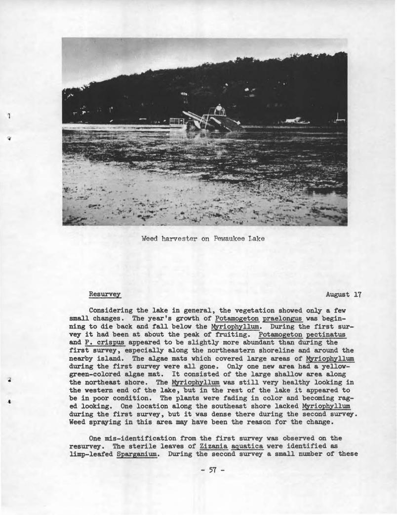
Weed harvester on Pewaukee I.ake
Resurvey August 17
Considering the lake in general, the vegetation showed only a few small changes • The year's growth of Potamogeton praelongus was beginning to die back and fall below the MYriophyllum. During the first survey it had been at about the peak of fruiting. Potamogeton pectinatus and P. crispus appeared to be slightly more abundant than during the first survey, especially along the northeastern shoreline and around the nearby island. The algae mats which covered large areas of Myriophyllum during the first survey were all gone. Only one new area had a yellowgreen-colored algae mat. It consisted of the large shallow area along the northeast shore. The MYriophyllum was still very healthy looking in the western end of the lake, but in the rest of the lake it appeared to be in poor condition. The plants were fading in color and becoming raged looking. One location along the southeast shore lacked Myriophyllum during the first survey, but it was dense there during the second survey. Weed sprQfing in this area may have been the reason for the change.
One mis-identification from t he first survey was observed on the resurvey. The sterile leaves of Zizania aquatica were identified as limp-leafed Sparganium. During the second survey a small number of these
- 57 -

plants in fruit were observed and positively identified. Lemna was the only genus of aquatic plants found which was not noticed during the first survey.
Spring Lake July 13
Spring Lake is a 107-acr e lake with a maximum depth of 22 feet. It m~ have a small area 44 feet deep if a farmer who lives near the lake is correct. The 22-foot maximum is in the center of the southern half of the lake. The northern half is 2 feet or less deep. Secchi disk readings were nine feet.
Nitella was the only plant found in water from 10 to 17 feet deep. It was dense in this depth range. At about 10 feet Chara began to appear and by 9 feet was heavy with sparse Potamogeton pectinatus mixed in with it. In water of 6 feet and less, Potamogeton spp. (narrow leaf), P. pectinatus, and P . gramineus were found in sparse amounts except along the southeast shore where P. gramineus was dense. Chara usually thinned out near shore. In the norther n half Chara was dense to sparse with only P. gramineus mixed in with it. A few dense patches of Po1ygonum natans and some sparse Utricularia, Nymphaea and Nuphar were also seen on the north half of the lake near shore in among the Scirpus.
Emergents consisted of Scirpus sparsely covering a considerable area of the north end of the lake. It also occurred along the lake edge with other sedges . On the west end of the lake, Typha covered the shoreline with a few small patches of Scirpus.
Floating leafed plants consisted of Nymphaea and Nuphar. Nymphaea was sparse on the north half shoreline and moderately abundant near shore on the west side. Nuphar was also sparse on the north half of the lake along the shore and had a considerable sized bed off shore on the west side.
Lake use during the survey consisted of two groups out in boats fishing.
The farmer who owned the land where we launched felt the lake did not have a weed problem and he also felt that the weeds that were there helped the fishing. The most apparent problem on the lake was the shallowness of the north end.
The farmer knew of no herbicide spraying. No weed harvester has been used on the lake either, but cottage owners on the east shore pulled out a stand of cattails, the farmer reported .
Upper Phantom Lake August 28
Upper phantom Lake is a 106-acre lake with a maximum depth of 29 feet. The slope of the bottom varies from gradual to steep. Secchi disk readings of 8 and 9 feet were recorded and vegetation was recovered from depths as great as 22 feet.
- 58 -
1
J
1
•
Submergent vegetation near shore (0 to 15 feet deep) consisted mainly of Chara and Najas flexilis. Vallisneria was common but not as abundant as the former. Less common were Potamogeton amineus, Ceratophyllum, Myriophyllum, Potamogeton spp. (broad leaf , Utricularia, P. amplifolius, Najas marina, Potamogeton spp. (narrow leaf),~ richardsonii, P. oakesianus and Anacharis in about that order of decreasing abundance. Bottom areas between a depth of 15 and 22 feet either lacked vegetation or were dominated by Nitella, with small amounts of Najas flexilis and Ceratophyllum also present.
Emergent plants were uncommon with the majority seen along the south shore. Cyperaceae (sedges) were abundant in this area with some Scirpus among it. Decodon and a small amount of TYpha were also observed.
Floating leaf plants were scarce, only occurring along the south and southeast shore. Both ~ae~ and Nuphar were present.
Lake use during the survey consisted of 4 boats being used for fishing, one for water skiing and 3 people swimming.
A boat livery owner stated that an association of cottage owners have a mechanical weed harvester which they use on the lake. He also has heard of some limited spraying on the lake •
- 59 -
LITERATURE CITED
Curtis, J. T. 1959. The vegetation of Wisconsin. University of Wisconsin Press,
Madison.
Dane, C. W. 1959. Succession of aquatic plants in small artificial marshes in
New York State. N. Y. Fish and Game Jour. 1 (1):57-76.
Fassett, N. C. 1960. A manual of aquatic plants. University of Wisconsin Press,
l
Madison. ~
Jessen, R. and R. Lound 1962. An evaluation of a survey technique for submerged aquatic
plants. Minn. Dept. of Conserv., Game Investigational Report No. 6.
Martin, A. D., H. S. Zim and A. L. Nelson 1951. American wildlife and plants, a guide to food habits. Dover
Publications, Inc. New York.
Swindale, L. D. and J. T. Curtis 1957. Phytosociology of the larger submerged plants in Wisconsin
lakes. Ecology 38:397-407.
- 60 -
J

l
)

J
I r
J


![Infra [ initiatives ]](https://static.fdocuments.us/doc/165x107/589ecd381a28ab47138b61d3/infra-initiatives-.jpg)