Depositional history of the fluvial Lower Carboniferous ... · facies association 1) composed of...
13
65 Geology of Greenland Survey Bulletin 187, 65–77 (2000) © GEUS 2000 Depositional history of the fluvial Lower Carboniferous Sortebakker Formation, Wandel Sea Basin, eastern North Greenland Finn Dalhoff and Lars Stemmerik The Lower Carboniferous non-marine Sortebakker Formation is restricted to the south coast of Holm Land. It is estimated to exceed 1000 m in thickness and is subdivided by a low-angle disconformity into a lower mudstone-dominated unit (c. 335 m) and an upper sand-dominated unit (c. 665 m). The lower mudstone-dominated succession consists of stacked 0.5–6 m thick fining-upward cycles of fine- to medium-grained sandstone and mudstone. Cycles in the upper part of the formation are up to 20 m thick. They are dominated by thick tabular sandstones up to 13 m thick overlain by shaly units that resemble those in the lower mudstone dominated cycles. Six facies associations are identified and together describe a fluviatile–lacustrine deposi- tional system. Five of the facies associations characterise different parts of a meandering river- dominated flood plain whereas the sixth facies association represents more permanent lakes. Geological Survey of Denmark and Greenland, Thoravej 8, DK-2400 Copenhagen NV, Denmark. E-mail: [email protected] Keywords: Carboniferous, depositional environments, North Greenland, Sortebakker Forma- tion, Wandel Sea Basin The Lower Carboniferous non-marine Sortebakker Formation in Holm Land, eastern North Greenland (Fig. 1), was deposited during the initial phase of Late Pal- aeozoic rifting of the northern North Atlantic and the Arctic Ocean. Time equivalent non-marine deposits are known from central East Greenland, Svalbard, west- ern Barents Sea and Arctic Canada (e.g. Steel & Worsley 1984; Gjelberg 1987; Davies & Nassichuk 1988; Stem- merik et al. 1991; Bugge et al. 1995). Sedimentation took place in a humid climate and in most areas the sedimentary succession dominantly consists of humid- type fluvial deposits with some coal. The Sortebakker Formation (Stemmerik & Håkans- son 1989) consists of approximately 1000 m of stacked fining-upward cycles of fluvial sandstone and mud- stone with minor lacustrine deposits in the upper part. The formation is divided by a low-angle disconformity into a lower mudstone-dominated unit (c. 335 m thick) composed of 0.5–6 m thick fining-upward cycles and an upper sand-dominated unit (c. 665 m thick) com- posed of up to 10–20 m thick fining-upward cycles. Even finer scale cyclicity is seen within the fine-grain- ed parts of each cycle, and three levels of cyclicity are recognised within the succession. This paper describes the depositional facies of the Sortebakker Formation and discusses the controls on the different levels of cyclicity seen within this fluvial succession. Geological setting In eastern North Greenland, Lower Carboniferous sedi- ments are restricted to Sortebakker on the south coast of Holm Land (Fig. 1; Stemmerik & Håkansson 1989). The Sortebakker Formation is approximately 1000 m thick and rests directly on Precambrian basement. It is unconformably overlain by Upper Carboniferous (Mo- scovian), marine deposits (Håkansson & Stemmerik 1984). The Sortebakker Formation is internally subdi- vided by a low-angle, possibly tectonically induced dis- conformity. Prior to deposition of the overlying ma- rine sediments, the formation was faulted and eroded; modelling data indicate that as much as 2000 m of
Transcript of Depositional history of the fluvial Lower Carboniferous ... · facies association 1) composed of...

65Geology of Greenland Survey Bulletin 187, 65–77 (2000) © GEUS 2000
Depositional history of the fluvial Lower CarboniferousSortebakker Formation, Wandel Sea Basin, eastern NorthGreenland
Finn Dalhoff and Lars Stemmerik
The Lower Carboniferous non-marine Sortebakker Formation is restricted to the south coast ofHolm Land. It is estimated to exceed 1000 m in thickness and is subdivided by a low-angledisconformity into a lower mudstone-dominated unit (c. 335 m) and an upper sand-dominatedunit (c. 665 m). The lower mudstone-dominated succession consists of stacked 0.5–6 m thickfining-upward cycles of fine- to medium-grained sandstone and mudstone. Cycles in the upperpart of the formation are up to 20 m thick. They are dominated by thick tabular sandstones upto 13 m thick overlain by shaly units that resemble those in the lower mudstone dominatedcycles. Six facies associations are identified and together describe a fluviatile–lacustrine deposi-tional system. Five of the facies associations characterise different parts of a meandering river-dominated flood plain whereas the sixth facies association represents more permanent lakes.
Geological Survey of Denmark and Greenland, Thoravej 8, DK-2400 Copenhagen NV, Denmark.E-mail: [email protected]
Keywords: Carboniferous, depositional environments, North Greenland, Sortebakker Forma-tion, Wandel Sea Basin
The Lower Carboniferous non-marine SortebakkerFormation in Holm Land, eastern North Greenland (Fig.1), was deposited during the initial phase of Late Pal-aeozoic rifting of the northern North Atlantic and theArctic Ocean. Time equivalent non-marine deposits areknown from central East Greenland, Svalbard, west-ern Barents Sea and Arctic Canada (e.g. Steel & Worsley1984; Gjelberg 1987; Davies & Nassichuk 1988; Stem-merik et al. 1991; Bugge et al. 1995). Sedimentationtook place in a humid climate and in most areas thesedimentary succession dominantly consists of humid-type fluvial deposits with some coal.
The Sortebakker Formation (Stemmerik & Håkans-son 1989) consists of approximately 1000 m of stackedfining-upward cycles of fluvial sandstone and mud-stone with minor lacustrine deposits in the upper part.The formation is divided by a low-angle disconformityinto a lower mudstone-dominated unit (c. 335 m thick)composed of 0.5–6 m thick fining-upward cycles andan upper sand-dominated unit (c. 665 m thick) com-posed of up to 10–20 m thick fining-upward cycles.Even finer scale cyclicity is seen within the fine-grain-
ed parts of each cycle, and three levels of cyclicity arerecognised within the succession.
This paper describes the depositional facies of theSortebakker Formation and discusses the controls onthe different levels of cyclicity seen within this fluvialsuccession.
Geological setting
In eastern North Greenland, Lower Carboniferous sedi-ments are restricted to Sortebakker on the south coastof Holm Land (Fig. 1; Stemmerik & Håkansson 1989).The Sortebakker Formation is approximately 1000 mthick and rests directly on Precambrian basement. It isunconformably overlain by Upper Carboniferous (Mo-scovian), marine deposits (Håkansson & Stemmerik1984). The Sortebakker Formation is internally subdi-vided by a low-angle, possibly tectonically induced dis-conformity. Prior to deposition of the overlying ma-rine sediments, the formation was faulted and eroded;modelling data indicate that as much as 2000 m of
GEUS Bulletin no 187.p65 28-11-00, 12:3565

66
17°
Sortebakker Depotfjeld80°10′
80°10′
Wandel Sea
PTØ
Prinsesse IngeborgHalvø
Kilen
Kronp
rins
Christ
ianLa
nd
Ingolf Fjord
AmdrupLand Henrik Krøyer
Holme
82°
81°
80°
18° 14° 10°
Conglomerate resting on Precambrian basement Sortebakker Formation
Marine Upper Carboniferous Kap Jungersen and Foldedal Formations
Ice cover
Boundary established
Boundary inferredPrecambrian basement
17°
b
a
c
b
Contour interval 100 m
c
Mesozoic and Palaeogene
Ice cover
Carboniferous and Permian
Cambrian–Silurian
Proterozoic
Fault
Precambrian basement
PTØ Prinsesse Thyra Ø
5 km
LandStructuralhighsDepositionalcentres
Fault
Holm Land
6105 8
411
9 7
Svalbard
FinnmarkPlatform
Bjørnøya
BB
WSB
HAB
HBNorth
Greenland
WSB
HolmLand
250 km
Wandel SeaBasin
50 km
GEUS Bulletin no 187.p65 28-11-00, 12:3566

67
Fig. 1. a: Map with major structural outline and palaeogeographicreconstruction of the Wandel Sea and Barents Sea regions.Modified from Stemmerik & Worsley (1995). b: Simplified geo-logical map of Kronprins Christian Land and environs showingthe distribution of Upper Palaeozoic sediments. Modified fromStemmerik et al. (1994). For location, see Fig. 1a. c: Geologicalmap of the southern part of Holm Land showing distribution ofthe Sortebakker Formation. Numbers 4–11 indicate the loca-tions of Figs 4–11. For location, see Fig. 1b.
0
10
20
30
40
m
MSi m
c
f
MSi m
c
f
MSi m
c
f
0
10
20
m
Sandstone
Siltstone
Mudstone
Coal
Lithology
Large-scale planarcross-bedding
Large-scale troughcross-bedding
Weak lamination
Structureless
Structures/textures
Plant fragments
A
B
1000
m ?
900
800
700
600
500
400
300
100
0
Parallel lamination
Disconformity
Mud
Silt
Fine sand
Medium sand
Coarse sand
B
AUpwards-fining units
M
Si
f
m
c
Fig. 2. Composite sedimentological log from the SortebakkerFormation with two representative detailed vertical sections com-prising several complete cycles as indicated by the triangles. A:from lower part; B: from upper part above the disconformity.For location of sections, see Fig. 3. The total thickness is esti-mated to exceed 1000 m.
GEUS Bulletin no 187.p65 28-11-00, 12:3567

68
100
m
9407
21-1
WE
Dis
conf
orm
ity
GEUS Bulletin no 187.p65 28-11-00, 12:3568

69
sediments were eroded away prior to the Late Carbon-iferous transgression (Stemmerik et al. 1998). The up-per part of the formation is dated as Viséan (Dalhoff etal. 2000, this volume) which means that depositionwas coeval with that of the lower part of the Traill ØGroup in East Greenland (Vigran et al. 1999) and theBillefjorden Group on Svalbard and its equivalents inthe Barents Sea.
Sedimentation apparently took place in an isolatedbasin separated to the west by a major fault zone fromthe stable Greenland craton and to the north boundedby a basement high (Fig. 1). The western part of thedepositional basin is not preserved and the studiedoutcrops are believed to represent deposition in theaxial zone of the basin. The basin forms part of theLate Palaeozoic – Mesozoic rift system which startedto form between Greenland and Norway during theEarly Carboniferous (Stemmerik et al. 1991). The riftsystem extended westwards between North Greenlandand Svalbard to the Sverdrup Basin of Arctic Canadaand eastwards through the Nordkapp Basin in theBarents Sea. During Early Carboniferous times, non-marine sedimentation dominated within the rift sys-tem and marine deposits were limited to the FinnmarkPlatform in the easternmost parts of the rift (Bugge etal. 1995).
Sedimentary facies
Thirty-two sedimentological sections through variousparts of the Sortebakker Formation in the coastal cliffsof Sortebakker form the basis for this study (Fig. 2).Correlation of individual sections is based on tracingbeds in the field and on photographs. The outcropsallow firm lateral correlation of individual channel sandsfor approximately 500 m in the lower part of the suc-cession and for more than 1000 m in the upper part
(Fig. 3). Six facies associations are defined, five of whichcharacterise different parts of a meandering river sys-tem and one facies association represents lacustrinesedimentation.
Facies association 1: channel sandstones
This association includes three different channel sand-stones: (1) thin, tabular 0.5–4 m thick multistorey sand-stone units, (2) thick, up to 13 m thick, units of tabularmultistorey sandstone, and (3) isolated, laterally con-fined sandstone units.
(1) Thin tabular sandstone units. The thin tabular sand-stones consist of 0.5–4 m thick, laterally persistent units
Fig. 3. Extensive fining-upward fluvial deposits from the east-ern part of the Sortebakker Formation in a coastal cliff sectionbetween Sortebakker and Depotfjeld from 17°W and 1.5 kmwestward in Fig. 1. The line drawing shows correlation of thelower surface of some of the thickest channel sandstones. Thedashed line marks the disconformity dividing the formation intoa lower mudstone-dominated unit and an upper sand-domi-nated unit. The thick lines mark the positions of measured sedi-mentary sections. The detailed vertical section A in Fig. 2, formsthe lower part of the sedimentary section 940721-1. Section Bof Fig. 2 is located westward of the outcrops shown on thephotograph. The cliff is approximately 350 m high.
Fig. 4. Thin tabular sandstones of facies association 1 (Fa1) over-lain by sediments of facies association 2 (Fa2), together form-ing stacked fining-upward fluvial cycles. Individual cycles areindicated by the triangles. Thickness of section shown on pho-tograph is approximately 13 m. For location, see Fig. 1c.
Fa2
Fa2
Fa1
Fa1
2 m
GEUS Bulletin no 187.p65 28-11-00, 12:3569

70
of medium- to fine-grained sandstone. Individual bedsmay be up to 1 m thick, but are usually 0.3–0.5 mthick. The base of the sandstone bed is usually sharpand erosional, commonly with mudflake clasts. Thesandstone is typically structureless; in rare cases, inter-
vals of cross-bedded or cross-laminated sandstone oc-cur. This facies is capped by mudstone or siltstonebelonging to facies association 2 (Figs 3, 4). This faciesis limited to the lower part of the formation, below thedisconformity.
(2) Thick tabular sandstone units. The thick tabularsandstones form up to 13 m thick fining-upward unitsgrading from medium- to fine-grained sandstone tomudstone; the thickest units are laterally persistent andhave been traced for more than a kilometre (Figs 3, 5).Pebbly lag deposits occur rarely at the base of thesandstone where they consist of coarse-grained peb-bly (< 1 cm) sandstone with large coaly plant fragments.Sedimentary structures are rare and mainly consist oftrough cross-bedding. The sandstone passes upwardsinto fining-upward units of medium- to fine-grainedsandstone. They are well sorted, light grey to yellow-ish in colour and display weak bedding, up to 2 mthick, but usually about 0.5 m thick. The sandstonesmay be structureless, or show planar or trough cross-bedding. The planar cross-bedding is seen as tabularsets; cosets of weak cross-bedded sandstone occur lo-cally. Intraformational clasts of mudstone and siltymudstone, plant remains and groove marks are ob-served in the sandstone, and in places tree stumps ingrowth position are seen to extend vertically up fromthe underlying beds. The upper part of these sand-stones display ripple cross-lamination and, locally, in-ternal deformation structures such as convolutebedding. Mudstones or siltstones belonging to faciesassociation 2 generally cap this facies. Transition from
Fig. 5. Thick tabular sandstone unit (Ch:facies association 1) composed of twostoreys, erosively overlying coals (C)from facies association 6. The arrowmarks the erosive base of the channelsandstone. Person for scale. For location,see Fig. 1c.
Fig. 6. Laterally confined sandstone units of facies association1, marked by arrows, enclosed by fine-grained lake deposits.Thickness of illustrated section is approximately 65 m. For lo-cation, see Fig. 1c.
Ch
Ch
C
GEUS Bulletin no 187.p65 28-11-00, 12:3570

71
facies association 1 to facies association 2 can be ei-ther gradational or abrupt. The thick tabular sandstoneunits are only present above the disconformity andinferred epsilon cross-stratification has only been ob-served in one, inaccessible locality.
(3) Isolated, laterally confined sandstone units. Thesesandstone bodies have a maximum thickness of 3–15m and a maximum width of up to 25 m (Fig. 6). Theyhave a concave and undulating erosional base, oftenshowing groove marks, and they commonly consist ofa basal coarse-grained to conglomeratic lag whichpasses upwards into medium-grained sandstone. Themedium-grained sandstone consists of massive, planarand trough cross-bedded sets, 0.5–2 m thick, with abun-dant poorly preserved coaly plant fragments in thelower part. The erosional basal contact is typically in-cised into sediments belonging to facies association 4,and there is commonly a sharp boundary between theisolated, laterally confined sandstone units (1) and as-sociation 4.
Measurement of palaeocurrent directions in the threetypes of channel sandstone was only possible in a fewplaces. Groove casts trend NE–SW and ripple cross-lamination indicates palaeocurrents towards the north-east.
Interpretation. The multistorey sandstones (1) and (2)are interpreted as fluvial channel deposits. The sand-stones represent lateral and vertical accretion and themultistorey character of the sandstone bodies is theresult of lateral meander loop migration during net
aggradation (Allen 1963; Bridge 1975; Bridge & Diemer1983; Diemer & Belt 1991). Each storey is a single pointbar deposit which was superimposed on a previouspoint bar deposit (e.g. Bridge 1975). The scarcity ofsedimentary structures and the presence of convolutebedding may reflect rapid fall out from suspension (Col-linson & Thompson 1989), or it may be an artifact dueto difficulties observing internal structures. However,the presence of in situ tree stumps indicates limitederosion and deposition from suspension. The thick-ness variations of the sandstone units probably reflectvariable discharge with time, implying that the thick-ness of the channel deposits roughly equals the maxi-mum depth of the channel, although the degree ofaccretion and erosion are also factors controlling bedthickness. A meandering system is the most obviousconsidering the scarcity of planar tabular cross-bed-ding which is typically produced by bars in sandybraided systems (Gersib & McCabe 1981); angular andtrough-shaped cross-bedding are interpreted as theproduct of migration of dunes and sandwaves (Collin-son & Thompson 1989).
The laterally confined sandstone units (3) are inter-preted as channel-fill deposits from a fixed channel.Fixed channels produce laterally restricted sand rib-bons commonly isolated in finer grained sediment (Col-linson 1986). The infilling of sand enclosed by finerdeposits suggests a combined load stream with a highsuspended load. Furthermore, it implies a gradualwaning of flow in the channel so bedload transportpersisted approximately to the time of abandonment(Allen 1964; Collinson 1986).
Fig. 7. Wedge-shaped structurelesssandstone bed of crevasse splay origin(Fa3: facies association 3) embedded infloodplain deposits of facies association 2(Fa2) composed of laminated to weaklylaminated mudstone. Pencil for scale. Forlocation, see Fig. 1c. Fa2
Fa3
Fa2
GEUS Bulletin no 187.p65 28-11-00, 12:3571
72
Facies association 2: overbank fines
Description. This facies association comprises up to 10m thick units of laminated to weakly laminated mud-stone and siltstone interbedded with thin-beddedstructureless sandstone and parallel-laminated siltysandstone (Fig. 7). In the lowermost part of the forma-tion rare 0.5–3 cm thick coal streaks occur within thisfacies. The overbank fines association has a transitionalor planar to irregular base and comprises mainly fin-ing-upward units with flaser and lenticular bedding.Locally, coarsening-upward units are observed. Thesandstone beds are 0.5–10 cm thick with wavy or pla-nar lower and upper boundaries. Successions of thistype usually overlie the channel sandstone of faciesassociation 1. Poorly preserved plant fragments are theonly fossils recorded in this association. The facies as-
sociation can be traced laterally for more than a kilo-metre.
Interpretation. Facies association 2 records depositionof fine material from suspension and is closely compa-rable to facies 6 of Fielding (1984). Deposition tookplace in interchannel areas. The fine-grained units rep-resent the result of vertical accretion of floodplain de-posits. The thin intercalations of massive and ripplecross-laminated sandstone represent infrequent over-bank flooding, where bedload capacity was sufficientto transport sand material into the flood basin areas(Fielding 1984; Farrell 1987; Diemer & Belt 1991). Thecoarsening-upward units are interpreted to representinfilling of the interchannel areas by fine-grained splaysediments as minor delta lobes. The thin coal streaksare thought to represent detrital organic matter trans-ported into the interchannel areas during flooding (Al-exander & Gawthorpe 1993).
Facies association 3: crevasse splaysandstones
Description. Facies association 3 comprises up to 5 mthick units of composite medium- to fine-grained sand-stone. Individual beds are up to 1.5 m thick and theylocally contain lens-shaped clasts of mudstone up to10 cm across (Fig. 7). The base is sharp, planar orwavy and erosional. The sandstone is structureless orplanar cross-bedded, laminated or ripple cross-lami-nated. Flattened coaly clasts of plant debris and treestumps are sometimes preserved, but no other fossilshave been found. Individual beds are often wedge-shaped; when stacked into thicker units, they formtabular sheets. The thickest units are laterally persist-ent for more than 500 m along the cliff exposure andno channel forms are recognised. However, the sand-stone may split laterally into 10–40 cm thick beds, alter-nating with mudstone and siltstone from faciesassociation 2. In a few places, above the disconform-ity, structureless beds up to 40 cm thick are seen to berecumbently folded whilst bedding above and beloware undisturbed.
Interpretation. The sediments were deposited byunconfined erosional flows. The stacked sandstoneswere deposited in a fluctuating discharge regime dur-ing several flood pulses. Comparable sediments havebeen described by McKee et al. (1967), Tunbridge(1981) and Fielding (1984). Tunbridge (1981) inter-
Fig. 8. Interbedded fine-grained sandstone (St) and siltstone(Si) from facies association 4 overlying a thin-bedded unit offine-grained sandstone from facies association 3 (Fa3). Noticecross-lamination (Cl) above the pencil. For location, see Fig.1c.
Cl
St
St
St
St
St
Fa3
Si
Si
Si
GEUS Bulletin no 187.p65 28-11-00, 12:3572

73
preted laterally persistent sandy sediments with bedthickness of 0.4–2.5 m arranged in stacked sequencesand with no indication of channelling having formedduring high-stage flood deposition of sand followedby rapid waning of flow, with little or no low-stagereworking. The sediments represent vertical accretionat some distance from a feeder channel and are inter-preted as crevasse splay deposits. The recumbentlyfolded beds are interpreted as the result of syndeposi-tional slump movements on the basis of the undis-turbed nature of the bedding below and above.
Facies association 4: levee heteroliths
Description. Facies association 4 comprises thinly bed-ded heterolithic units, up to 0.9 m thick, consisting ofweakly laminated or non-laminated mudstone to silt-stone alternating with fine-grained sandstone. Suchunits commonly succeed sediments of facies associa-tion 1 (Fig. 8). The sandstone sets are generally 1–2 cmthick, massive or weakly cross-laminated, followed by2–12 cm thick lamina sets of rippled siltstone to fine-grained sandstone. Only rare plant fragments have beenobserved. Locally this facies association forms coar-sening-upward sequences in which sandstones becomedominant towards the top. In one section theheterolithic units are arranged in multistorey sequencesup to 10 m thick separated by up to 0.5 m thick ero-sional beds of sandstone. These sandstone beds arestructureless or horizontally planar or ripple cross-lami-nated with an erosional base.
This facies association is difficult to trace laterally; iteither interfingers with sediments of facies association2 or is cut by sediments of facies association 1.
Interpretation. These units are interpreted as leveesediments where each sedimentary rhythm representsa flood event. Fielding (1984), Diemer & Belt (1991),and Platt & Keller (1992), among others, have describedsimilar sediments were the heterolithic deposition isinterpreted to represent variation in discharge. The coar-sening-upward trend is considered to reflect infillingof interchannel areas by growth or encroachment ofthe levee. The erosionally based sandstone beds rep-resent sediment-laden floods from the crevasse splayassociation and the scarcity of rootlets suggests sub-aqueous deposition (Fielding 1984).
Facies association 5: lake
Description. Facies association 5 consists of dark brownto reddish brown laminated to non-laminated mud-stone and silty mudstone sequences up to 28 m thick.Poorly preserved plant fragments are common. Hori-zons enriched with iron and iron-rich concretions arelocally present. Thin, sharp-based beds (5–10 cm) ofstructureless, laminated and ripple cross-laminated, fine-grained silty sandstone beds are common in thesemudstones. They occasionally show desiccation cracks(Fig. 9).
This association is laterally persistent over severalhundreds of metres. The lateral transition is not clearly
Fig. 9. Fine-grained sandstone withdesiccation cracks (facies association 5).The hammer is 32 cm long. For location,see Fig. 1c.
GEUS Bulletin no 187.p65 28-11-00, 12:3573

74
observed but the sediments seem to wedge out later-ally. Facies association 5 is cut by laterally restricted,sharp-based channel deposits of facies association 1(Fig. 6).
Interpretation. The uniform fine grain size and the scar-city of current generated structures suggest that faciesassociation 5 was deposited from suspension in pro-tected basins and accordingly this facies association isinterpreted to represent shallow lake deposits. The thinsandstone beds represent distal flood deposits or eventsof lowered lake level and the basins were periodicallysubaerially exposed as indicated by the occurrence ofdesiccation cracks.
Facies association 6: swamp
Description. This facies association is composed of thin,generally less than 1 m thick, coal and shaly coal beds.Thin beds (< 0.1 m) of mudstone or silty mudstoneand ripple-laminated or horizontal planar-laminatedfine-grained sandstones are occasionally present withinthe coal (Fig. 10). The coal is black to brownish blackwith sparse rootlet horizons. Locally, vertical treestumps in growth position are seen to penetrate up-wards into the overlying sediments. Facies association6 can only be traced laterally for about 200 m.
Interpretation. This association probably represents theorganic deposits of peat swamps (Fielding 1984). Theswamp evolved through the prolific growth of vegeta-tion on the shallow submerged and abandoned sur-faces of lake infills and channels. Whether these coalsare entirely autochthonous is impossible to determinebecause of the scarcity of rootlet horizons below andwithin facies association 6 as a whole. The thicknessand distribution of the coals may indicate an autocyclicorigin whereas relatively thin and discontinuous coalseams can be interpreted to reflect local sedimentarycontrol by the channels (Belt et al. 1992). The thinintercalated clastic beds are the result of overbank sedi-mentation in the swamp area (McCabe 1984).
Depositional environment
The lack of evidence of marine proximity or evidenceof tidal current processes, the abundance of plant re-mains including in situ stems and coal beds and thestacking pattern of the six facies associations suggestdeposition in a fluviatile sedimentary environment. Theindividual fining-upward successions and their char-acteristic sedimentary structures cannot be taken asproof of a meandering fluvial environment (Miall 1992).However, the overall stacking patterns and the distri-bution of facies associations 1–4 and 6 are in accord-ance with other inferred ancient meandering riverdeposits (e.g. Allen 1965; Leeder 1973; Puigdefabregas& Van Vliet 1978; Bridge & Diemer 1983; Diemer &Belt 1991; Alexander & Gawthorpe 1993), and the sedi-ments are thought to represent a complete fossil me-ander belt where the sandstones represent theindividual active channels.
Amalgamation of the channel sandstones reflectsdownstream progradation of the meanders in associa-tion with aggradation. The channel and floodplain
Fig. 10. A thick coal bed with thin intercalated fine-grainedsandy beds overlain by thick tabular sandstone units (2) offacies association 1. Person for scale. For location, see Fig. 1c.
GEUS Bulletin no 187.p65 28-11-00, 12:3574
75
deposits are interpreted to represent sedimentation inchannels of moderate to high sinuosity on the adja-cent floodplain. The channel sandstones are thoughtto have been deposited in moderately high sinuositystreams based on the few channel bodies observed.The finer sediments in facies associations 2 to 6 arelaterally and vertically associated with facies associa-tion 1 and accumulated as flood basin, crevasse splay,levee, shallow lake and swamp deposits. The thickflood basin sequences probably reflect a more stableflood basin area, distant from the main meander belts,where stream channels had only minor influence onsedimentation. The final shift towards mixed lacustrineand fluvial deposition reflects a change in base levelpossibly due to increased rates of subsidence, changesin sediment supply or increased precipitation andthereby raised ground water level.
If the thickness of the sandstones corresponds tooriginal channel depth (Collinson 1986), the maximumchannel depths were in the order of 3 to 13 m for theupper part of the formation. The lower half of theformation is dominated by facies association 2 sug-gesting deposition from rivers with an even largeramount of suspended load leading to more extensiveflood basin deposits. The channels were shallower thanin the upper part with a maximum depth of c. 4 m.
Cyclicity
Two orders of cyclicity can be seen in the Lower Car-boniferous succession. The thickest cycles consist of
interbedded channel sandstones and overbank fines.Each cycle starts with lateral accretion or avulsion, andscouring of the underlying beds, followed by infillingof the channel or part of it by vertical accretion ofsandstone. The cycle is terminated by overbank finesthat are erosively overlain by sandstones of the fol-lowing cycle.
Cycle thickness is 0.5–6 m below the disconformitywith an average thickness around 2 m. Cycles fromthe upper part of the succession range from 3 to 20 mwith an average around 11 m. They are dominated bythick tabular channel sandstones up to 13 m thick.This change in cycle thickness is abrupt and appar-ently reflects a shift from a broad distant floodplain,where the meandering stream channels had limitedinfluence on sedimentation, to a more proximal or lat-erally confined floodplain where channels were morefrequent. The change in cycle thickness and the asso-ciated shift from mudstone-dominated cycles belowthe disconformity to sand-dominated cycles above sug-gest an analogy with the 1st order cycles in alluvialsediments of Schumm (1977), McLean & Jerzykiewicz(1978) and Wescott (1993) and may be related to tec-tonic disturbance. Syntectonic disturbance is also indi-cated by the recumbent slump folds in facies association3. This disturbance may have led to changes in baselevel followed by changes in discharge, sediment sup-ply and the river transport capacity.
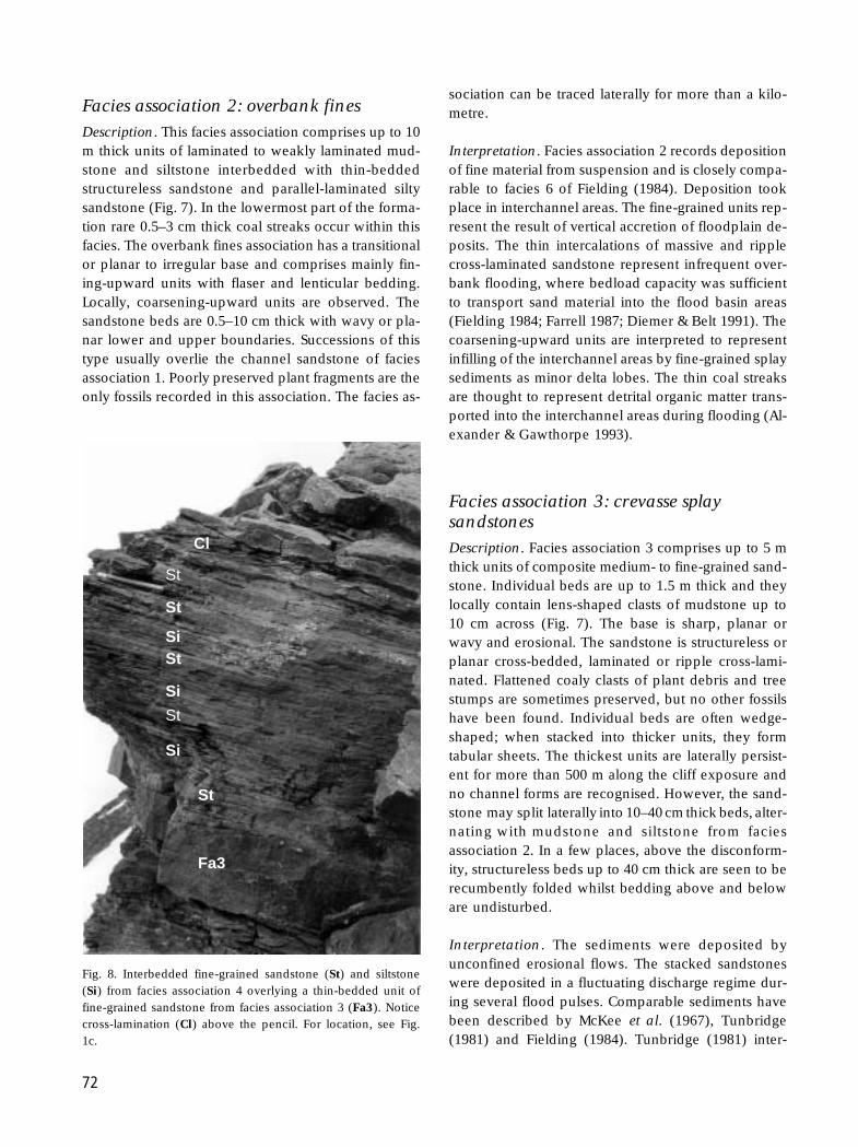
Cyclicity on an even finer scale is represented inthe overbank fines. Each cycle consists of a basal thin-bedded, fine-grained sandstone followed by massiveto planar or ripple cross-laminated, fine-grained silt
StSt
StSt
St St
Fig. 11. Fine-grained sandstones (St) andsilty mudstones from facies association 2arranged in a cyclic pattern. Notice theoverall fining-upward trend. The ruler asscale is 20 cm long. For location, see Fig.1c.
GEUS Bulletin no 187.p65 28-11-00, 12:3675

76
and silty mudstone (Fig. 11). Cycle thickness rangesfrom a few tens of centimetres to about 1 m. Thesecycles represent vertical accretion deposits and areinterpreted to be of autocyclic origin (McLean &Jerzykiewicz 1978; Farrell 1987). This type of cyclicityis comparable to the 3rd order cyclicity of McLean &Jerzykiewicz (1978) and the 3rd and 4th order cyclesof Schumm (1977) and Wescott (1993).
Conclusions
The Sortebakker Formation consists of a variety of faciesthat together characterise deposition on a floodplain.The sediments stack in a cyclic fashion with a shiftthrough time from thin mudstone-dominated cycles tothick sand-dominated cycles; the uppermost part ofthe succession consists of mixed fluvial and lacustrinedeposits. The 1st order cyclicity that led to the devel-opment of an angular disconformity, is interpreted tohave been allogenetic in origin. It was related to majorchanges in accommodation space and is thought tohave been created by tectonic movement. The cyclicitybelow and above the disconformity is interpreted tohave been controlled by autocyclic processes. The fin-ing-upward fluvial cycles are interpreted to recordunhindered meandering of a river across a floodplainunder conditions of steady subsidence and sedimentsupply (e.g. Friend 1961; Allen 1964). This kind ofcyclicity is referred to as 2nd order cyclicity by McLean& Jerzykiewicz (1978) and as 3rd order cyclicity bySchumm (1977) and Wescott (1993). Allocyclic mecha-nisms such as climatic fluctuations and base levelchanges are reported to produce cyclicity equivalentto that observed in the Sortebakker Formation, andthese mechanisms may alternatively explain the ob-served patterns.
Acknowledgement
This paper forms a contribution to the project ‘Re-sources of the sedimentary basins of North and EastGreenland’ that is supported by the Danish ResearchCouncils.
ReferencesAlexander, J. & Gawthorpe, R.L. 1993: The complex nature of a
Jurassic multistorey, alluvial sandstone body, Whitby, NorthYorkshire. In: North, C.P. & Prosser, D.J. (eds): Characteriza-tion of fluvial and aeolian reservoirs. Geological Society (Lon-don) Special Publications 73, 123–142.
Allen, J.R.L. 1963: The classification of cross-stratified units, withnotes on their origin. Sedimentology 2, 93–114.
Allen, J.R.L. 1964: Studies in fluviatile sedimentation: Sixcyclothems from the Lower Old Red Sandstone, Anglo-WelshBasin. Sedimentology 3, 163–198.
Allen, J.R.L. 1965: Fining-upwards cycles in alluvial successions.Geological Journal 4, 229–246.
Belt, E.S., Sakimoto, S.E.H. & Rockwell, B.W. 1992: A drainage-diversion hypothesis for the origin of widespread coal bedsin the Williston Basin: examples from Paleocene strata, east-ern Montana. In: Scholes, M.A. & Vuke-Foster, S.M. (eds):Coal geology of Montana. Special Publication of MontanaBureau of Mines and Geology 102, 21–60.
Bridge, J.S. 1975: Computer simulation of sedimentation inmeandering streams. Sedimentology 22, 3–43.
Bridge, J.S. & Diemer, J.A. 1983: Quantitative interpretation ofan evolving ancient river system. Sedimentology 30, 599–623.
Bugge, T., Mangerud, G., Elvebak, G., Mørk, A., Nilsson, I.,Fanavoll, S. & Vigran, J.O. 1995: The Upper Palaeozoic suc-cession on the Finnmark Platform, Barents Sea. NorskGeologisk Tidsskrift 75, 3–30.
Collinson, J.D. 1986: Alluvial sediments. In: Reading, H.G. (ed.):Sedimentary environments and facies, 2nd edition, 20–62.Oxford: Blackwell Scientific Publication.
Collinson, J.D. & Thompson, D.B. 1989: Sedimentary structures,2nd edition, 207 pp. London: Unwin Hyman.
Dalhoff, F., Vigran, J.O. & Stemmerik, L. 2000: Stratigraphy andpalynology of the Lower Carboniferous Sortebakker Forma-tion, Wandel Sea Basin, eastern North Greenland. In: Stem-merik, L. (ed.): Palynology and deposition in the WandelSea Basin, eastern North Greenland. Geology of GreenlandSurvey Bulletin 187, 51–63 (this volume).
Davies, G.R. & Nassichuk, W.W. 1988: An Early Carboniferous(Viséan) lacustrine oil shale in Canadian Arctic Archipelago.American Association of Petroleum Geologists Bulletin 72,8–20.
Diemer, J.A. & Belt, E.S. 1991: Sedimentology and paleohydrau-lics of the meandering river systems of the Fort Union For-mation, southeastern Montana. Sedimentary Geology 75, 85–108.
Farrell, K.M. 1987: Sedimentology and facies architecture ofoverbank deposits of the Mississippi River, False River re-gion, Louisiana. In: Ethridge, F.G., Flores, R.M. & Harvey,M.D. (eds): Recent developments in fluvial sedimentology.Society of Economic Paleontologists and Mineralogists Spe-cial Publication 39, 111–120.
Fielding, C.R. 1984: Upper delta plain lacustrine and fluvio-lacustrine facies from the Westphalian of the Durham coal-field, NE England. Sedimentology 31, 547–567.
GEUS Bulletin no 187.p65 28-11-00, 12:3676

77
Friend, P.F. 1961: The Devonian stratigraphy of north and cen-tral Vestspitsbergen. Proceedings of the Yorkshire Geologi-cal Society 33, 77–118.
Gersib, G.A. & McCabe, P.J. 1981: Continental coal-bearing sedi-ments of the Port Hood Formation (Carboniferous), CapeLinzee, Nova Scotia, Canada. In: Ethridge, F.G. & Flores, R.M.(eds): Recent and ancient nonmarine depositional environ-ments. Society of Economic Paleontologists and Mineralo-gists Special Publication 31, 95–108.
Gjelberg, J. 1987: Early Carboniferous graben style and sedi-mentation response, Svalbard. In: Miller, J., Adams, A.E. &Wright, V.P. (eds): European Dinantian environments, 93–113. Chichester: John Wiley.
Håkansson, E. & Stemmerik, L. 1984: Wandel Sea Basin – theNorth Greenland equivalent to Svalbard and the Barents Shelf.In: Spencer, A.M. et al. (eds): Petroleum geology of the northEuropean margin, 97–107. London: Graham & Trotman forthe Norwegian Petroleum Society,
Leeder, M. 1973: Sedimentology and palaeogeography of theUpper Old Red Sandstone in the Scottish Border Basin. Scot-tish Journal of Geology 9, 117–144.
McCabe, P.J. 1984: Depositional environments of coal and coal-bearing strata. In: Rahmani, R.A. & Flores, R.M. (eds): Sedi-mentology of coal and coal-bearing sequences. InternationalAssociation of Sedimentologists Special Publication 7, 13–42.
McKee, E.D., Crosby, E.J. & Berryhill Jr, H.L. 1967: Flood de-posits, Bijou Creek, Colorado, June 1965. Journal of Sedi-mentary Petrology 37, 829–851.
McLean, J.R. & Jerzykiewicz, T. 1978: Cyclicity, tectonics andcoal: some aspects of fluvial sedimentology in the Brazeau-Paskapoo Formations, Coal Valley area, Alberta, Canada. In:Miall, A.D. (ed.): Fluvial sedimentology. Canadian Society ofPetroleum Geology Memoir 5, 441–468.
Miall, A.D. 1992: Alluvial deposits. In: Walker, R.G. & James,N.P. (eds): Facies models, response to sea level change, 119–142. Ontario: Geological Association of Canada.
Platt, N.H. & Keller, B. 1992: Distal alluvial deposits in a fore-land basin setting – the Lower Molasse (Lower Miocene),Switzerland: sedimentology, architecture and palaeosols.Sedimentology 39, 545–565.
Puigdefabregas, C. & Van Vliet, A. 1978: Meandering streamdeposits from the Tertiary of the southern Pyrenees. In: Miall,
A.D. (ed.): Fluvial sedimentology. Canadian Society of Pe-troleum Geologists Memoir 5, 469–485.
Schumm, S.A. 1977: The fluvial system, 338 pp. New York: JohnWiley & Sons.
Steel, R.J. & Worsley, D. 1984: Svalbard’s post-Caledonian strata– an atlas of sedimentational patterns and palaeogeographicevolution. In: Spencer, A.M. et al. (eds): Petroleum geologyof the north European margin, 109–135. London: Graham &Trotman for the Norwegian Petroleum Society.
Stemmerik, L. & Håkansson, E. 1989: Stratigraphy and deposi-tional history of the Upper Palaeozoic and Triassic sedimentsin the Wandel Sea Basin, central and eastern North Green-land. Rapport Grønlands Geologiske Undersøgelse 143, 21–45.
Stemmerik, L. & Worsley, D. 1995: Permian history of the BarentsShelf area. In: Scholle, P.A., Peryt, T.M. & Ulmer-Scholle,D.S. (eds): The Permian of northern Pangea: sedimentarybasins and economic resources 2, 81–97. Berlin: SpringerVerlag.
Stemmerik, L., Vigran, J.O. & Piasecki, S. 1991: Dating of latePaleozoic rifting events in the North Atlantic: new biostrati-graphic data from the uppermost Devonian and Carbonifer-ous of East Greenland. Geology 19, 218–221.
Stemmerik, L., Dalhoff, F. & Nilsson, I. 1994: Petroleum-geo-logical studies in eastern North Greenland. In: Henriksen,N. (ed.): Express report, eastern North Greenland and North-East Greenland, 69–76. Unpublished report, Geological Sur-vey of Greenland, Copenhagen, Denmark.
Stemmerik, L., Dalhoff, F., Larsen, B.D., Lyck, J., Mathiesen, A.& Nilsson, I. 1998: Wandel Sea Basin, eastern North Green-land. Geology of Greenland Survey Bulletin 180, 55–62.
Tunbridge, I.P. 1981: Sandy high-energy flood sedimentation –some criteria for recognition, with an example from the Dev-onian of S. W. England. Sedimentary Geology 28, 79–95.
Vigran, J.O., Stemmerik, L. & Piasecki, S. 1999: Stratigraphy anddepositional evolution of the uppermost Devonian–Carbon-iferous (Tournaisian–Westphalian) non-marine deposits inNorth-East Greenland. Palynology 23, 115–152.
Wescott, W.A. 1993: Geomorphic thresholds and complex re-sponse of fluvial systems – some implications for sequencestratigraphy. American Association of Petroleum GeologistsBulletin 77, 1208–1218.
GEUS Bulletin no 187.p65 28-11-00, 12:3677