Depositional Facies and Petrophysical Analysis of the Bakken
49
Depositional Facies and Petrophysical Analysis of the Bakken Formation, Parshall Field, Mountrail County, North Dakota Andrea Simenson Colorado School of Mines November 18, 2010
Transcript of Depositional Facies and Petrophysical Analysis of the Bakken

Depositional Facies and Petrophysical Analysis of the Bakken Formation, Parshall
Field, Mountrail County, North Dakota
Andrea SimensonColorado School of Mines
November 18, 2010

Acknowledgements
Dr. S. A. Sonnenberg Dr. J. F. Sarg Dr. M. Prasad Robert Cluff Discovery Group Fellow Bakken students


Outline Introduction
• Study area, data set, etc. Core Results
• Facies descriptions• Environment of deposition
Well Log Analysis• Model used• Results and mapping
Source-Rock Characteristics• Organic richness & thermal maturity
Conclusions

Lear Pet Expl Parshall SD 1Sec. 3-T152N-R90W
Lodgepole
Ba
kken
Upper Shale
Middle Mbr.
Lower Shale
Three Forks “Sanish”
“Sanish”
“False Bakken”
CSM consortium, Nov 2008

Limit LowerBakken Shale
Limit MiddleBakken
Limit Bakken
1970-80sUpper Bakken Shale Depositional Edge
PlayPost 1987
Horizontal Play
AntelopeField
Sanish & Bakken1953
Elm Coulee2001-P
Horizontal Middle Bakken
Structure Bakken Formation
BakkenSanish
The Bakken Cycles
Robinson Lake & Parshall Field Area
2006-P
CSM consortium, Nov. 2008

Study Area
Modified from LeFever (2008)

Study Area Dataset
T. 147-164N R. 84-99W: 5,700 mi2
Approximately 900 vertical wells with Bakken penetrations, 135 wells with digital logs
10 cores from the NDGS and Fidelity
249 source rock samples, 28 from Parshall Field

Objective and Purpose
Understand the depositional environment of the BakkenFormation in the Parshall Field area
Determine the reservoir quality by applying an integrated petrophysicalanalysis approach

Methods
Detailed core descriptions Lithology, environment of deposition,
reservoir properties, mapping Build petrophysical model using
digital logs available Source rock analysis: organic
richness, thermal maturity, etc.

Core Descriptions
Facies identification and description
Log calibration

Core Locations

Facies C1 & C2(10,102 – 10,119 feet)(3,079.1 – 3,084.3 meters)
Facies A(10,142 – 10,146 feet)(3,091.3 – 3,092.5 meters)
Facies B(10,119 – 10,142 feet)(3,084.3 – 3,091.3 meters)
Facies D1 & D2(10,084 – 10,102 feet)(3,073.6 – 3,079.1 meters)
Facies G(10,146 – 10,192 feet)(3,092.5 – 3,106.5 meters)
Facies G(10,077 – 10,077 feet)(3,071.5 – 3,071.5 meters)
Facies E1, E2 & F(10,077 – 10,084 feet)(3,071.5 – 3,073.6 meters)
L. Bakken
M. Bakken
U. Bakken
Deadwood Canyon Ranch #43-28H

Middle Bakken Facies
Facies A
Muddy lime wackestone Crinoid and brachiopod
shell fragments common Common burrows Absence of waves and
currents Suspension deposition,
deposit-feeder traces
From Long #1-01H9,171.9 ft (2,795.6 m)

Middle Bakken Facies
Facies B
Bioturbated, argillaceous, calcareous, very fine-grained sandstone/siltstone
Helminthopsis/Sclaritubadominant trace fossils
Possible Planolites Sparse bivalves Local calcareous
concretions Sparse calcite-filled
vertical fractures From N & D #1-05H9,447.0 ft (2,879.4 m)

Middle Bakken Facies
Facies C1
Planar to undulose and discontinuous laminated, shaly, very fine-grained siltstone/sandstone
Crenulated/irregular bedding surfaces may be influenced by microbial activity
Local calcareous concretions
From Deadwood Canyon Ranch #43-28H10,112.7 ft (3,082.4 m)

Middle Bakken Facies
Facies C2
symmetrically ripple to undulose laminated, very fine-grained siltstone/sandstone
Local bioturbation Possible hummocky cross
stratification present
From Deadwood Canyon Ranch #43-28H
10,103.8 ft (3,079.6 m)
From Van Hook #1-13H9,470.8 ft (2,886.7 m)

Middle Bakken Facies
Facies D1
Contorted to massive fine-grained sandstone
Local soft sediment deformation
Common micro-faults and calcite-filled fractures
From Dobrinski #18-448,653.2 ft (2,637.5 m)
Middle Bakken Facies
Facies D2
Low angle, planar to slightly undulose, cross laminated sandstone with thin discontinuous shale laminations
Highly calcareous Some calcite-filled
fractures
From Deadwood Canyon Ranch #43-28H10,094.7 ft (3,076.9 m)

Middle Bakken Facies
Facies E1
Finely inter-laminated, bioturbated, dolomitic-mudstone and dolomitic siltstone/sandstone
Local contorted bedding and soft sediment deformation
Crenulated/irregular bedding surfaces may be influenced by microbial activity
Local ripples and possible hummocky cross stratification From Long #1-01H
9,146.0 ft (2,787.7 m)

Middle Bakken Facies
Facies E2
Calcitic, whole fossil, dolomitic-to lime wackestone
Fossil rich beds contain crinoid fragments and brachiopods found as articulated shells, single valves, or shell fragments
Found interspersed with facies E1
From Fertile #1-12H9,372.5 ft (2,856.7 m)
From Van Hook #1-13H9,460.0 ft (2,883.4 m)
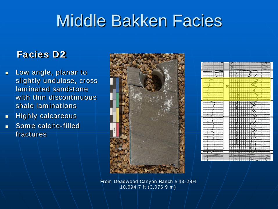
Middle Bakken Facies
Facies F
Bioturbated, shaly, dolomitic siltstone
Sometimes mottled looking
Local beds of homogeneous/ planar laminated dolomiticsiltstone
From Jensen #12-449,170.1 ft (2,795.0 m)

Upper and Lower Bakken Facies
Facies G
Organic rich, pyritic, brown/black mudstone
Planar laminated Horizontal and
vertical fractures cemented with calcite and pyrite
Local thin sideriticbeds, sparsely burrowed
Upper Bakken
Lower Bakken
From Deadwood Canyon Ranch #43-28H
10,174.0 ft (3,101.0 m)
From Long #1-01H9,135.0 ft (2,784.3 m)

Environment of Deposition
A
B
C D
E
F
Modified from Smith and Bustin (1996)
HST
LST
TST

Deadwood Canyon Ranch #43-28H
Upper Bakkenmfs
mfs
E and Fts
SBD
TST
LST
HST
C
B
A
Lower Bakken

Stratigraphic cross section grid shown on the Middle Bakken isopach map

West to east stratigraphic section with the Upper Bakken as the datum
Lower Bakken and Facies C,B,A thinning to the east
Facies D not present in all of the wells

Facies A and B
From Long #1-01H9,171.9 ft (2,795.6 m)
A
B
From N & D #1-05H9,447.0 ft (2,879.4 m)

Facies C
From Deadwood Canyon Ranch #43-28H10,112.7 ft (3,082.4 m)
C1
C2
From Deadwood Canyon Ranch #43-28H
10,103.8 ft (3,079.6 m)
From Van Hook #1-13H9,470.8 ft (2,886.7 m)

Facies D
D1
D2
From Dobrinski #18-448,653.2 ft (2,637.5 m)
From Deadwood Canyon Ranch #43-28H
10,094.7 ft (3,076.9 m)

Facies E and F
From Jensen #12-449,170.1 ft (2,795.0 m)
From Fertile #1-12H
9,372.5 ft (2,856.7 m)
From Long #1-01H
9,146.0 ft (2,787.7 m)
E2
F
E1

Well Log Analysis
Logs• GR• Resistivity• Acoustic Compressional
and Shear• Density• Neutron
Formation Tops
Core Data• Porosity• Grain density• Gas permeability• Permeability to air• Water saturation• Oil saturation

Deadwood Canyon Ranch #43-28H Type Well

Calculate Sw and BVW
Archie’s Water Saturation equation• a=1; n=1.74;
m=varied by facies• Rw = 0.02• Rt = Deep Resistivity
n
tm
w
RaRSwφ
=
Bulk Volume Water• Used Total Method wT SPHIXBVW *=

Calculate Permeability
Used a generalized form of the Timur Model for permeability calibrated with core data
KSWIEXP
KPHIEXP
coef SWIPHIXKK =log
62500=coefK
VariedKKPHIEXP =
0.2=KSWIEXPK
by facies

Facies E & F
Facies D
Facies C
Facies B
Facies A
m=1.75 KPHIEXP = 4.8
m=1.40 KPHIEXP = 5.7
m=1.50 KPHIEXP = 5.6
m=1.65 KPHIEXP = 5.3
m=1.80 KPHIEXP = 5.0
For all faciesa=1 ; n=1.74

Average Sw for the Middle Bakken

Net pay determination

Net feet of pay for the Middle Bakken

Source Rock Richness
Determination of total organic carbon (TOC)
Schmoker and Hester (1983) method using formation density
Passey et al. (1990) method using formation density
261.574.154−
=
ρTOC
( ) ( )LOMRTOC ×−×∆= 1688.0297.210log

TOC ComparisonSanish Field Parshall Field

Upper Bakkenaverage TOCusing the Schmoker and Hester equation

Lower Bakkenaverage TOCusing the Schmoker and Hester equation

Source Rock Type
Published data from Webster (1984) and Price et al. (1984), Parshall data from NDGS

Source Rock Maturity
Published data from Webster (1984) and Price et al. (1984), Parshall data from NDGS

Conclusions Middle Bakken has 9 distinct facies representing a
offshore to tidally influenced inner shelf environment
Good correlation between core facies identified and their corresponding log characteristics
Good correlation between core and log porosity Well log analysis suggest that a variable m works
for a better water saturation model Variable KPHIEXP gets a better permeability
model

Conclusions Water saturations are low in Parshall Field and
increase along the eastern and southern edges of the field
Middle Bakken net pay interval averages 25 feet thick in Parshall and mainly consists of facies E1, C2, C1, and B
Calculated TOC values show an average of 12% in the Upper Bakken and 13% in the Lower Bakken
Rock-Eval data indicates the Bakken is mainly a Type II kerogen in Parshall

Questions?

References
LeFever, J., 2008, What’s Happening at Parshall, North Dakota: North Dakota Geological Survey Newsletter, v. 35, no. 1, p. 1-2.
Nordeng, S. H., and J. LeFever, 2008, The Bakken: A question of maturity: 16th Annual Williston Basin Petroleum Conference, North Dakota Geological Survey, PowerPoint presentation.
Nordeng, S. H., 2010, The Bakken source system: Emphasis on the Three Forks Formation: 18th
Williston Basin Petroleum Conference and Expo, North Dakota Geological Survey, PowerPoint presentation.
Passey, Q. R., S. Creaney, J. B. Kulla, F. J. Moretti, and J. D. Stroud, 1990, A practical model for organic richness from porosity and resistivity logs: AAPG Bulletin, v. 74, no. 12, p. 1777-1794.
Price, L. C., T. Ging, T.Daws, A. Love, M. Pawlewicz, and D. Anders, 1984, Organic metamorphism in the Mississippian - Devonian Bakken shale, North Dakota portion of the Williston Basin inWoodward J., F. F. Meissner, J. L. Clayton, eds., Hydrocarbon Source Rocks of the Greater Rocky Mountain Region, Denver, Colorado, Rocky Mountain Association of Geologists, p. 83-134.
Schmoker, J. W., and T. C. Hester, 1983, Organic carbon in the Bakken Formation, United States portion of Williston basin: AAPG Bulletin, v. 67, no. 12, p. 2165–2174.
Smith, M. G., and R. M. Bustin, 1996, Lithofacies and paleoenvironments of the Upper Devonian and Lower Mississippian Bakken Formation, Williston Basin: Bulletin of Canadian Petroleum Geology, v. 44, p. 495-507.
Webster, R. L., 1984, Petroleum source rocks and stratigraphy of the Bakken Formation in North Dakota in Woodward J., F. F. Meissner, J. L. Clayton, eds., Hydrocarbon source rocks of the greater Rocky Mountain region, Rocky Mountain Association of Geologists, p. 57 - 82.