Depositional Characteristics and Petroleum … and the Bongaya Formation. Sections of the rock units...
7
Sanudin et al /ICG 2015 1 Depositional Characteristics and Petroleum Exploration Potential of the Upper Miocene Sedimentary Sequence in East Sabah, Malaysia. Sanudin Tahir, Junaidi Asis and Baba Musta Faculty of Science and Natural Resources Universiti Malaysia Sabah [email protected] Abstract This study is to document facies associations of the Upper Miocene rock units recorded from the various locations in Sabah, Malaysia, namely; the Belait Formation, the Meligan Formation, the Kapilit Formation, the Sandakan Formation and the Bongaya Formation. Sections of the rock units were measured in detail to reveal their sequential variations and depositional environment as well as petrographic analysis to evaluate their reservoir characteristics. The measured sections are predominantly composed of interbedded sandstone and mudstone with shallow marine fossils and plant remains. The interbedded sandstone and mudstone regularly show sedimentary structures which are indicative of wave and tidal processes, such as swaley, hummocky, trough and planar cross stratifications. Bioturbation is common that include range of inchnofacies Skolithos to Cruziana, indicative of shoreface to inner neritic depositional environments. The major depositional systems, concluded as storm-dominated near shore package that includes five depositional facies, namely: tidal inlet facies, lagoon facies, upper to lower shoreface facies and inner shelf facies. This range setting from high tide level to below storm wave base is located between shoreline to inner shelf framework. The sequence grades up-section into facies sets of increasing tidal energy and terminate with the deposition within the tidal inlet setting. The arrangement of the facies suggests a pattern of normal regression of sedimentary successions in this part of Borneo during Upper Miocene. Petrographic analysis of different sandstone samples from different facies were used to demonstrate the diagenetic maturity of the rock units. Some selected sandstones for petrograpic analysis gave evidence of texturally and mineralogically mature quartz arenite with good sorting. However, the presence of unstable lithic grains and feldspars during diagenetic processes contributed to the reduction of porosity, giving irregular porosity due to history of sedimentation, and susceptibility to chemical alteration of labile minerals. Most observed porosity in the sandstone sequence is secondary, developed from dissolution of both carbonate cement and unstable framework grains. Lithic fragments, feldspars and authigenic cements were altered to form diagenetic mineral suites, which tend to occlude porosity; besides, dissolution and chemical reactions of some of these rock forming particles also enhanced secondary porosity development. Reservoir quality was also influenced by the subsequent diagenesis of the sandstones, which was driven by overburden pressure and could be culminated by continuously increasing temperature and pressure during the history of proceeding depth of burial. Mean porosity suggested trace of decreasing trend with increasing depth of burial. However, detailed examination of several localities revealed that the major secondary porosity development was strongly influenced by local factors. Thus, the Upper Miocene shoreline deposits in Sabah can be concluded as fair sandstone reservoir potential and could be a potential petroleum system which is very similar to the proven petroleum system in the adjacent area, the Kutei Basin. It is therefore recommended that further and more detailed studies to be conducted in this sedimentary sequence. Keywords: Sabah, Sedimentary facies and Petroleum Potential.
Transcript of Depositional Characteristics and Petroleum … and the Bongaya Formation. Sections of the rock units...
Sanudin et al /ICG 2015
1
Depositional Characteristics and Petroleum Exploration Potential ofthe Upper Miocene Sedimentary Sequence in East Sabah, Malaysia.
Sanudin Tahir, Junaidi Asis and Baba MustaFaculty of Science and Natural Resources
Universiti Malaysia [email protected]
Abstract
This study is to document facies associations of the Upper Miocene rock units recorded from the various locations inSabah, Malaysia, namely; the Belait Formation, the Meligan Formation, the Kapilit Formation, the SandakanFormation and the Bongaya Formation. Sections of the rock units were measured in detail to reveal their sequentialvariations and depositional environment as well as petrographic analysis to evaluate their reservoir characteristics.The measured sections are predominantly composed of interbedded sandstone and mudstone with shallow marinefossils and plant remains. The interbedded sandstone and mudstone regularly show sedimentary structures which areindicative of wave and tidal processes, such as swaley, hummocky, trough and planar cross stratifications. Bioturbationis common that include range of inchnofacies Skolithos to Cruziana, indicative of shoreface to inner neritic depositionalenvironments. The major depositional systems, concluded as storm-dominated near shore package that includes fivedepositional facies, namely: tidal inlet facies, lagoon facies, upper to lower shoreface facies and inner shelf facies. Thisrange setting from high tide level to below storm wave base is located between shoreline to inner shelf framework. Thesequence grades up-section into facies sets of increasing tidal energy and terminate with the deposition within the tidalinlet setting. The arrangement of the facies suggests a pattern of normal regression of sedimentary successions in thispart of Borneo during Upper Miocene. Petrographic analysis of different sandstone samples from different facies wereused to demonstrate the diagenetic maturity of the rock units. Some selected sandstones for petrograpic analysis gaveevidence of texturally and mineralogically mature quartz arenite with good sorting. However, the presence of unstablelithic grains and feldspars during diagenetic processes contributed to the reduction of porosity, giving irregularporosity due to history of sedimentation, and susceptibility to chemical alteration of labile minerals. Most observedporosity in the sandstone sequence is secondary, developed from dissolution of both carbonate cement and unstableframework grains. Lithic fragments, feldspars and authigenic cements were altered to form diagenetic mineral suites,which tend to occlude porosity; besides, dissolution and chemical reactions of some of these rock forming particles alsoenhanced secondary porosity development. Reservoir quality was also influenced by the subsequent diagenesis of thesandstones, which was driven by overburden pressure and could be culminated by continuously increasing temperatureand pressure during the history of proceeding depth of burial. Mean porosity suggested trace of decreasing trend withincreasing depth of burial. However, detailed examination of several localities revealed that the major secondaryporosity development was strongly influenced by local factors. Thus, the Upper Miocene shoreline deposits in Sabahcan be concluded as fair sandstone reservoir potential and could be a potential petroleum system which is very similarto the proven petroleum system in the adjacent area, the Kutei Basin. It is therefore recommended that further and moredetailed studies to be conducted in this sedimentary sequence.
Keywords: Sabah, Sedimentary facies and Petroleum Potential.

Sanudin et al /ICG 2015
2
Introduction
Upper Miocene sequence is probably anattractive frontier for the key area to thepetroleum exploration potential in Sabah.Previous worked and our recent study suggestedthat the area could contain potential petroleumsystems. The area represents the major Neogenebasins as identified onshore, the SandakanBasin. Equivalent rock unit is widely exposed inDent Peninsula, Sandakan Peninsula andnortheast Sabah (Figure 1).
Figure 1. Geology of eastern Sabah showing the UpperMiocene to Pliocene clastic sedimentary units.
The geology of Sabah was established bythe Geological Survey of Malaysia (JabatanMineral dan Geosains Malaysia), and excellentreports with high quality geological maps havebeen published that reveals the Upper Miocenelithostratigraphic units. Extensive investigationsfor oil and minerals have been conducted in theoffshore as well as onshore areas byPETRONAS and international oil companiessince 1970s to give better views. With thosecredits, researchers gain excellent baseline datafor the continuous collection of geological datato improve the understanding of the stratigraphyof Sabah. This study is to simplify theassociation of the Upper Miocene rock unitsthose were recorded from various locations inSabah, Malaysia, namely; the Belait Formation,the Meligan Formation, the Kapilit Formation,
the Sandakan Formation and the BongayaFormation. Sections of the rock units weremeasured in detail to reveal their sequentialvariations and depositional environment as wellas petrographic analysis to evaluate theirreservoir characteristics.
Material and Methods
The surface data and literature review of thearea were used for this study. Sampling stationsand measured sections were located within thetraverse area and were chosen to provide thedata for this study. In every station, field datasupport the lithofacies to do interpretation forevery selected outcrop. Among the importantdata is the lithology, geometry, grain size,sedimentary structures, thickness of the rocklayer and trace fossil distributions. The lithologylogs were then analysed and interpreted withrespect to the sedimentary facies and othercharacteristics to determine the depositionalenvironments. Fresh rock samples werecollected for petrographic analysis.
Geologic Setting and Stratigraphy
Extensive fieldwork data has been used todevelop palaeogeographic reconstructions ofSabah (Figure 2), which have in turn been usedto assess the sedimentary sequences of equalsetting during the late Middle Miocene toPliocene. The rock units those exposed in Sabahwith these equivalent ages, are the BelaitFormation, the Meligan Formation, the KapilitFormation, the Sandakan Formation, theTanjong Formation and the Bongaya Formationare dominated by clastic shoreline deposits, theTabanak Formation, the Sebahat Formation, TheGanduman Formation and the Togopi Formationwith locally influenced by channel feeding to theoffshore setting. The rock units are sitting on topof the Middle Miocene unconformity thatmarked as deep regional unconformity (DRU)revealed by offshore seismic data. Thisunconformity marked the top erosion limit of thedeep marine Palaeogene sequences of theBornean and wide spread to the neighbouringstratigraphy. The Middle Miocene DRU is

Sanudin et al /ICG 2015
3
marked by tremendously thick Mélange andvolcanic facies all over onshore Sabah and noneof the outcrops that differentiating between themélange and the volcanic facies show anyhiatus.
Seismic interpretation deduced thickTertiary sedimentary sequence and estimatedthat the upper section of the stratigraphic unitsare interpreted to be hydrocarbon potential. Thepotential reservoirs are expected to be within thestructural and stratigraphic traps of the cleanthick sandstone layers.
Figure 2. Paleogeographic reconstruction of northwestBorneo during Tertiary (Sanudin and Baba 2007).
These post-tectonic sedimentary unitsoccurred within the remnant of an accretionaryprism of the orogenic belt forming shallowmarine basins. The post-magmatic sequence wasmarked by the deposition of detritus within theLate Neogene circular basins of major areas ineast Sabah (Figure 3). The sediments of thecircular basins were unconformably depositedover deformed Palaeogene sequences, whichindicate intra-arc basin. This was followed bythe late Middle Miocene to Pliocene sedimentsof which are probably related to fore deep basinsedimentation that developed at the front of the
orogenic belt. This evidence is proven by thegeographical distribution that occupies the tipsof the peninsulas in east Sabah (Figure 3). Figure4 shows the simplified stratigraphy of the area.
Figure 3. Geological map of Sabah (modified from Yin
1985).
The Upper Miocene Sequence east Sabah
This study documents shallow marine faciesrecorded from the Miocene basins in east Sabah.The rock units identified include; the SebahatFormation, the Ganduman Formation, theTabanak Formation the Sandakan Formation, theBongaya Formation and the Togopi Formation.Sections of the rock units exposed onshore ineastern part of Sabah were examined andmeasured in detail to reveal their sequentialvariations and depositional environment. Thesuccessions of the sequence are exposures ofmajor shoreline to deltaic deposits of the regionduring the late Miocene. The sections arepredominantly composed of various thicknessesof interbedded sandstone and mudstone withindicative sedimentary structures, shallowmarine fauna and trace fossils. The sandstoneusually shows sedimentary structures which areindicative of storm, wave and tidal processes,such as swaley, hummocky, trough and planarcross stratifications (Figure 5). Figure 6 revealsthe vertical section of the interpreted shelfsequence from the selected composite sections.Bioturbation is common and include range ofinchnofacies Skolithos to Cruziana that indicateshoreface to inner shelf depositionalenvironments. The sequence grades up-sectioninto facies packages of increasing tidal energy
Sanudin et al /ICG 2015
4
and terminate with the deposition within theupper flow regime shoreline settings deltaic andtidal inlets. Silty samples collected from one ofthe circular basins in the Dent Peninsula areacontains nannofossils of at least Middle to LateMiocene age, namely Cyclococcolithusmacintyrei, Helicosphaera carteri,Cyclococcolithus leptoporus, Sphenoliythusabies, and Recticulofenestra pseudoumbilica(Rangin et al. 1990).
AGE ROCKUNIT
R S T Hc
PLEISTOCENE
TogopiFm
BongayaSandakan
Tb Gn………....Sebahat....Hiatus….
Volc. Fs………….Melange
Lst. Fs………….
LabangFm
PLIO.
Upper
Lower
MIOCENE
Upper
Middle
Lower
OLIGO
Upper
Lower
EOCENE
Upper
Middle
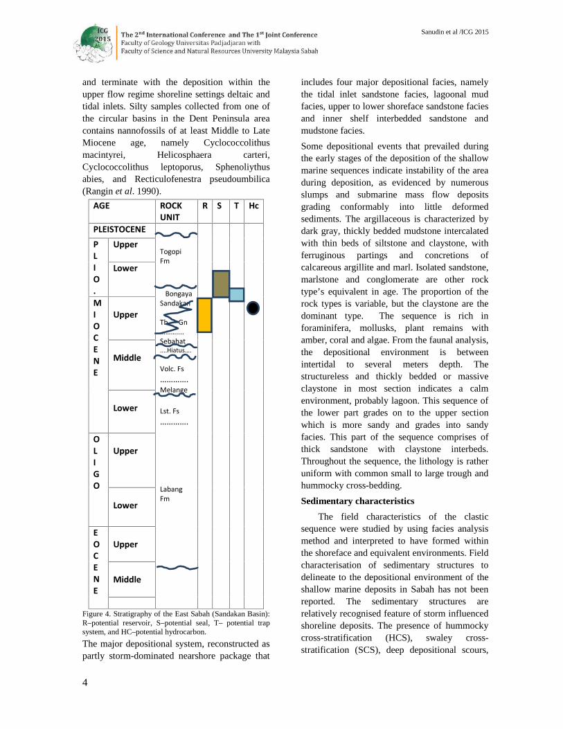
Figure 4. Stratigraphy of the East Sabah (Sandakan Basin):R–potential reservoir, S–potential seal, T– potential trapsystem, and HC–potential hydrocarbon.
The major depositional system, reconstructed aspartly storm-dominated nearshore package that
includes four major depositional facies, namelythe tidal inlet sandstone facies, lagoonal mudfacies, upper to lower shoreface sandstone faciesand inner shelf interbedded sandstone andmudstone facies.
Some depositional events that prevailed duringthe early stages of the deposition of the shallowmarine sequences indicate instability of the areaduring deposition, as evidenced by numerousslumps and submarine mass flow depositsgrading conformably into little deformedsediments. The argillaceous is characterized bydark gray, thickly bedded mudstone intercalatedwith thin beds of siltstone and claystone, withferruginous partings and concretions ofcalcareous argillite and marl. Isolated sandstone,marlstone and conglomerate are other rocktype’s equivalent in age. The proportion of therock types is variable, but the claystone are thedominant type. The sequence is rich inforaminifera, mollusks, plant remains withamber, coral and algae. From the faunal analysis,the depositional environment is betweenintertidal to several meters depth. Thestructureless and thickly bedded or massiveclaystone in most section indicates a calmenvironment, probably lagoon. This sequence ofthe lower part grades on to the upper sectionwhich is more sandy and grades into sandyfacies. This part of the sequence comprises ofthick sandstone with claystone interbeds.Throughout the sequence, the lithology is ratheruniform with common small to large trough andhummocky cross-bedding.
Sedimentary characteristics
The field characteristics of the clasticsequence were studied by using facies analysismethod and interpreted to have formed withinthe shoreface and equivalent environments. Fieldcharacterisation of sedimentary structures todelineate to the depositional environment of theshallow marine deposits in Sabah has not beenreported. The sedimentary structures arerelatively recognised feature of storm influencedshoreline deposits. The presence of hummockycross-stratification (HCS), swaley cross-stratification (SCS), deep depositional scours,

Sanudin et al /ICG 2015
5
and intraformational conglomerates indicatesthat storms were important depositional agentduring the accumulation of the sedimentary
Coarsening upwardsequence, upper section
Fine-grain sandstone, lowersection
Swaley cross bedding Hummocky cross bedding
Figure 5. Typical sedimentary structures indicative of
shoreline deposits from selected sections of the Upper
Miocene outcrops.
Figure 6. Sequence of the Upper Miocene shallow marinedeposits.
sequence (Figure 5). Combining informationfrom trace fossils and sedimentary structuresallow the subdivision of the sequence intodeposits of the upper shoreface, lower shorefaceand distal lower shoreface.
The sedimentary structures found can beinterpreted as a product of a combination of bothbed load transport and sediment falling off fromsuspension. The clastic facies composed ofmainly thick bedded sandstone interlayered withmedium to thin bedded shale and is representedby well-sorted, fine to coarse grained arenite.The coarse sandy deposits, mainly upper sectionof the sequence are characterised by hummockyand swaley cross stratification. Sandstones aretexturally and mineralogically mature quartzarenite with good sorting
Physical Characteristics of SelectedSandstone Samples
Petrographic analysis of sandstone samplesfrom selected locations were used todemonstrate the diagenetic maturity of the rockunits. Some selected sandstones for petrographicanalysis gave evidence of texturally andmineralogically mature quartz arenite with goodsorting. However, the presence of unstable lithicgrains and feldspars during diagenetic processescontributed to the reduction of pore spaces,giving irregular porosity due to history ofsedimentation, and susceptibility to chemicalalteration of labile minerals (Figure 7). Mostobserved porosity in the sandstone sequence issecondary, developed from dissolution of bothcarbonate cement and unstable framework labilegrains. Lithic fragments, feldspars andauthigenic cements were altered to formdiagenetic mineral suites, which tend to occludeporosity; besides, dissolution and chemicalreactions of some of these rock forming grainsalso enhanced secondary porosity development.Reservoir quality was also influenced by thesubsequent diagenesis of the sandstones, whichwas driven by overburden pressure and could beculminated by continuously increasingtemperature and pressure during the history ofproceeding depth of burial (Sanudin Tahir 2003).Mean porosity suggested trace of decreasingtrend with increasing depth of burial. However,detailed examination of several localitiesrevealed that themajor secondary porosity
20m
-------
-------
-------
- - - - - - -
-------
-------
-------
-------
............................
............................
....... .......
....... .......
............................
....... .......
....... .......
............................
....... .......
..............
............................
....... .......
....... .......
....... ....... .......
............................
....... .......
....... .......
..............
....... .......
.......
..............
....... .......
.......
- - - - - - -- - - - - - -
-------
-------
....... .............. .......
--------------
--------------
-------
---------------------
---------------------
---------------------
---------------------
---------------------
- - - - - - -- - - - - - -- - - - - - -
---------------------
---------------------
---------------------
---------------------------------------------------------------
----------------------------
--------------
.....................
..............
.....................
..............
.......
....... .......
.....................
..............
....... .......
. . . . . . .. . . . . . .. . . . . . .
. . . . . . .. . . . . . .
....... .......
..............
.....................
.......
-----------------------------------
..........................................
....... .............. .......
....... .............. ....... .............. .............. .......
..............
.....................
..............
............................
-------- - - - - - -- - - - - - -- - - - - - --------- - - - - - -
- - - - - - -- - - - - - -- - - - - - -- - - - - - -- - - - - - -- - - - - - -- - - - - - -
- - - - - - -- - - - - - -- - - - - - -- - - - - - -- - - - - - -- - - - - - -- - - - - - -
- - - - - - -- - - - - - -- - - - - - -- - - - - - -- - - - - - -- - - - - - -- - - - - - -
- - - - - - -- - - - - - -- - - - - - -- - - - - - -- - - - - - -- - - - - - -- - - - - - -
-------
..............
mud silt sand
Litholog Facies EnvironmentInterpretation
SequentEnvironment
Amalgamated and low angle planarcross-stratifiedcoarse grainedsandstone
Upper shoreface
Hummocky-swaleycross-stratifiedfine to coarsegrained sandstone
Lower shoreface
Rare hummockycross-stratifiedfine grainedsandstone-siltstoneinterbeds
Shoreface - shelftransition
Shelf

Sanudin et al /ICG 2015
6
development was strongly influenced by localfactors.
Figure 7. Photomicrograph of a selected sandstone sampleshowing general components.(Mo – monocrystallinequartz, Po – polycrystalline quartz, K – altered lithicfragments, I – altered feldspar and dark dirty appearanceare voids. Most of the grain contacts are tangential andlongitudinal types).
The organic source rock is matured (Table1) and is expected to be an intraformationalmudstone migrated up dip from a source deeperin the basin. Potential hydrocarbon kitchen areasin the basin are expected to be late MiddleMiocene argillaceous facies. Chemical analysisshown that terrestrial to shallow marine are theproper anticipated source rocks. Maturitywindow was tested by using ratios of oxygen-carbon and hydrogen-carbon giving the result ofmature migrated hydrocarbon. Hydrocarbonmigration from a source to the trap is expected tobe via permeable beds present in variousstratigraphic levels and fracture system. Timingof trap formation is not considered critical in thebasin since hydrocarbon generation frompotential source rocks continued up to thepresent day. The regional top seal of the basin isanticipated to be the Plio-Pleistocene fine-grained sequence that is thick andwidespreadonshore outcrops. Local top seals would beprovided by intra-formational clay stoneassociated with transitional to shallow watersequences. The potential traps present wereformed mostly during the Plio-Pleistocenecompressional phase although additionalpotential traps were formed during the post-rift.
Table 1. Analysed source rocks collected fromsome of the rock units exposed onshore.
Play Types
There are three major petroleum plays, theyare:
– Structural closures stacked with Late
Miocene reservoirs;
– Late Middle Miocene reefs, and;
– Late Miocene stratigraphic closures.
Conclusions and Recommendations
Thick sands deposited by delta andshoreline complexes around Borneo duringUpper Miocene have proven to be prolifichydrocarbon reservoirs, e.g.Bagram Delta andthe Mahakam delta. The Sandakan Basin at thepresent day is fed by a relatively large riversystems, e.g. Kinabatangan River and Segama
Sample
Proximate Analysis Ultimate Analysis
Moist.%
Ash%
VolatileMatter%
TotalSulphur %
C % H % O %
ST a 4.00 5.80 29.200.23 72.10 3.89 9.47
ST b 6.60 2.80 38.100.30 68.30 5.03 12.11
STc 5.30 2.60 38.400.35 71.20 5.20 11.25
SP1 0.80 4.00 48.000.91 78.70 6.14 8.93
SP2 2.80 1.70 40.600.43 76.80 5.45 9.38
SP3 2.10 1.60 43.900.30 79.10 5.91 9.98
SK1 2.0 26.9 33.30.44 58.40 4.61 11.17
SK2 1.10 30.80 33.001.74 52.60 4.17 11.01
SK3 1.10 28.90 33.701.74 53.10 4.02 10.13
KP1 0.99 4.51 37.640.85 71.58 5.60 11.98
KP2 1.01 3.95 38.011.03 73.22 5.59 12.01
KP3 1.87 2.44 37.910.72 46.93 5.56 10.45

Sanudin et al /ICG 2015
7
River could be the key evidence to the thicksedimentary sequence of the area. Seismic dataindicates the presence of a large offshoreregressive system and delta equivalentcomplexes (could be a combination of bothrivers mentioned).
One of the main challenges for oil and gasexploration in the area, part of the SandakanBasin, is therefore to understand the provenance,transport, deposition and distribution of sandwithin the basin, all of which have implicationsfor reservoir quality. In addition, part of thebasin has been affected by gravity tectonics,producing spectacular linked up dip extensionalstructures, all of which are likely to haveinfluenced local depositional transport.
High resolution seismic data andexperienced analyst are necessary to mapsedimentary systems within the Neogene Basinof the area to determine their interaction with theformation of sedimentary sequences. The resultscan be linked to onshore parts of the basin togive better view of the prospects. It may containa potential petroleum system that is very similarto the proven petroleum system in theneighbouring areas, e.g. Kutei Basin and BaramDelta. It is therefore recommended that furtherand more detailed studies be conducted in thearea the future addition hydrocarbon prospects inSabah.
ReferencesRangin,C.; Bellon, H.; Bernard, F.; Letouzey, J.; Muller,C.
and Sanudin,T. 1990. Neogene arc-continent collisionin Sabah, North Borneo (Malaysia). Tectonophysics,(183): 305-3190
Rangin, C; Muller, C; Letouzey, J; Stephan, J.F.;Chorowicz, J; Bernard, F; Butterlin, J.; Bellon, H.;Sanudin, T.; Baladad, D.; and Berrador, A. 1989. Arc-continent collision in Sabah and Panay Island(Philippines): Some constraints on the Cenozoicevolution of Sulu Sea marginal basin. Proc. Int. Symp.Geodyn. Evolut. Eastern Eurasian Margin, Paris.
Sanudin Tahir 2003. Geologi Petroleum. Penerbit UMS:Kota Kinabalu, 377 p.
Sanudin Tahir and Baba Musta 2007. Pengenalan kepadastratigrafi. Penerbit UMS: Kota Kinabalu, 203 p.
Yin, E.H. 1985. Geological map of Sabah. Scale,1/500,000. Geol. Surv. Malaysia.