Prevalence of physical activity and obesity in US counties, 2001--2011: a road map for action

United States Department of Agriculture
Natural Resources Conservation Service
In cooperation with Texas AgriLife Research
Soil Survey of Edwards and Real Counties, Texas


How To Use This Soil Survey
General Soil Map
The general soil map, which is a color map, shows the survey area divided into groups of associated soils called general soil map units. This map is useful in planning the use and management of large areas.
To find information about your area of interest, locate that area on the map, identify the name of the map unit in the area on the color-coded map legend, then refer to the section General Soil Map Units for a general description of the soils in your area.
Detailed Soil Maps
The detailed soil maps can be useful in planning the use and management of small areas.
To find information about your area of interest, locate that area on the Index to Map Sheets. Note the number of the map sheet and go to that sheet.
Locate your area of interest on the map sheet. Note the map unit symbols that are in that area. Go to the Contents, which lists the map units by symbol and name and shows the page where each map unit is described.
The Contents shows which table has data on a specific land use for each detailed soil map unit. Also see the Contents for sections of this publication that may address your specific needs.
i

ii
This soil survey is a publication of the National Cooperative Soil Survey, a joint effort of the United States Department of Agriculture and other Federal agencies, State agencies including AgriLife Research, and local agencies. The Natural Resources Conservation Service has leadership for the Federal part of the National Cooperative Soil Survey.
Major fieldwork for this soil survey was completed in 1995. Soil names and descriptions were approved in 2000. Unless otherwise indicated, statements in this publication refer to conditions in the survey area in 2000. This survey was made cooperatively by the Natural Resources Conservation Service and Texas AgriLife Research. The survey is part of the technical assistance furnished to the Edwards and Real Soil and Water Conservation District.
Soil maps in this survey may be copied without permission. Enlargement of these maps, however, could cause misunderstanding of the detail of mapping. If enlarged, maps do not show the small areas of contrasting soils that could have been shown at a larger scale.
The U.S. Department of Agriculture (USDA) prohibits discrimination in all its programs and activities on the basis of race, color, national origin, age, disability, and where applicable, sex, marital status, familial status, parental status, religion, sexual orientation, genetic information, political beliefs, reprisal, or because all or part of an individual’s income is derived from any public assistance program. (Not all prohibited bases apply to all programs.) Persons with disabilities who require alternative means for communication of program information (Braille, large print, audiotape, etc.) should contact USDA’s TARGET Center at (202) 720-2600 (voice and TDD). To file a complaint of discrimination, write to USDA, Director, Office of Civil Rights, 1400 Independence Avenue, S.W., Washington, D.C. 20250-9410, or call (800) 795-3272 (voice) or (202) 795-6382 (TDD). USDA is an equal opportunity provider and employer. Cover: A view along the Frio River in the Eckrant-Rock outcrop, steep to very steep general soil map
unit in the foreground and background, and the Real-Mailtrail, nearly level to hilly general soil map unit in the valley. The steep slopes are the Eckrant soil series. The flood plain is Dev and Oakalla soils and Riverwash. The cropland above the floodplain is the Campwood, Knippa, Rio Frio, and Vanderpool soils. The brushy footslopes of the hills are the Real and Mailtrail soils.
Additional information about the Nation’s natural resources is available on the Natural Resources Conservation Service homepage on the World Wide Web. The address is http://www.nrcs.usda.gov

Contents
How to Use This Soil Survey ...........................................................................i Foreword ........................................................................................................ vii General Nature of the Survey Area .................................................................. 2
History......................................................................................................... 3 Natural Resources ...................................................................................... 3 Transportation............................................................................................. 3 Economy ..................................................................................................... 3 Climate........................................................................................................ 3
How this Survey Was Made ............................................................................. 5 Survey Procedures ..................................................................................... 5
General Soil Map Units .................................................................................. 7 1. Eckrant-Rock outcrop, nearly level to hilly.............................................. 7 2. Eckrant-Rock outcrop, steep and very steep.......................................... 7 3. Ector-Rock outcrop-Eckrant, nearly level to very steep.......................... 8 4. Oplin-Eckrant-Rock outcrop, nearly level to very steep.......................... 8 5. Eckrant-Prade, nearly level to hilly ......................................................... 9 6. Real-Mailtrail, nearly level to hilly ........................................................... 9 7. Ector-Rock outcrop, nearly level to very steep ..................................... 10 8. Rock outcrop-Langtry-Ector, nearly level to very steep........................ 10 9. Spires, gently undulating ...................................................................... 10
Detailed Soil Map Units................................................................................ 13 CkB—Campwood-Knippa complex, 0 to 3 percent slopes....................... 14 CoB—Cho-Angelo complex, limestone substratum,
0 to 2 percent slopes........................................................................... 16 DeB—Dev-Riverwash complex, 0 to 3 percent slopes,
frequently flooded................................................................................ 18 DnD—Dina-Eckrant complex, 1 to 8 percent slopes ................................ 20 EcF—Eckrant-Rock outcrop complex, 1 to 20 percent slopes ................. 22 EcG—Eckrant-Rock outcrop complex, 20 to 60 percent slopes .............. 24 ErB—Ector gravelly silty clay loam, 1 to 3 percent slopes ....................... 26 ErF—Ector-Rock outcrop complex, 1 to 20 percent slopes...................... 27 ErG—Ector-Rock outcrop complex, 20 to 60 percent slopes................... 29 IrA—Irion clay, 0 to 1 percent slopes........................................................ 31 KrD—Kerrville-Real complex, 1 to 8 percent slopes ................................ 32 KrF—Kerrville-Real complex, 8 to 40 percent slopes............................... 34 LaE—Langtry-Rock outcrop complex, 1 to 15 percent slopes ................. 36 LkB—Leakey silty clay loam, 1 to 3 percent slopes ................................. 38 MaD—Mailtrail very gravelly clay loam, 1 to 8 percent slopes ................. 40 MmC—Mailtrail-Mereta complex, 0 to 5 percent slopes........................... 41 NuB—Nuvalde clay loam, 1 to 3 percent slopes, rarely flooded .............. 43 OdA—Oakalla-Dev complex, 0 to 2 percent slopes, flooded ................... 44 OrA—Orif soils, frequently flooded ........................................................... 46 OrG—Oplin-Rock outcrop complex, 20 to 60 percent slopes .................. 47 PeB—Prade-Eckrant complex, 0 to 3 percent slopes .............................. 49 PIT—Pits................................................................................................... 51 PrC—Prade-Tarrant complex, 2 to 5 percent slopes................................ 52 PtB—Pratley clay, 1 to 3 percent slopes .................................................. 54
iii

RaF—Real-Oplin complex, 1 to 20 percent slopes .................................. 55 RdB—Rio Diablo silty clay, 0 to 2 percent slopes, rarely flooded ............ 57 RfB—Rio Frio-Vanderpool complex, 0 to 2 percent slopes,
rarely flooded ...................................................................................... 59 RsB—Riverwash and Dev soils, 0 to 3 percent slopes,
frequently flooded................................................................................ 61 RtG—Rock outcrop-Langtry complex, 15 to 60 percent slopes ............... 63 StC—Spires-Tarpley complex, 1 to 5 percent slopes............................... 64 TeA—Tarrant-Eckrant complex, 0 to 2 percent slopes............................. 66 TvB—Tarrant-Valera complex, 0 to 3 percent slopes............................... 68 VaA—Valera clay, 0 to 2 percent slopes .................................................. 70 W—Water ................................................................................................. 71
Prime Farmland ............................................................................................ 73 Use and Management of the Soils .............................................................. 75
Interpretive Ratings................................................................................... 75 Rating Class Terms............................................................................. 75 Numerical Ratings............................................................................... 75
Crops and Pasture.................................................................................... 76 Management of Cropland ................................................................... 76 Management of Pasture and Hayland ................................................ 77 Management of Orchards ................................................................... 77
Yields Per Acre ......................................................................................... 77 Land Capability Classification................................................................... 78 Rangeland................................................................................................. 79 Rangeland Productivity............................................................................. 81
Ecological Sites................................................................................... 82 Limestone Hill 14-19" PZ Ecological Site ....................................... 82 Steep Rocky 14-19" PZ Ecological Site.......................................... 83 Clay Loam 19-23" PZ Ecological Site ............................................. 83 Limestone Hill 19-23" PZ Ecological Site ....................................... 83 Steep Rocky 19-23" PZ Ecological Site.......................................... 84 Draw 19-31" PZ Ecological Site...................................................... 84 Clay Flat 14-19" PZ Ecological Site ................................................ 85 Clay Loam 23-31" PZ Ecological Site ............................................. 85 Low Stony Hill 23-31" PZ Ecological Site ....................................... 85 Shallow 23-31" PZ Ecological Site.................................................. 86 Steep Rocky 23-31" PZ Ecological Site.......................................... 86 Very Shallow 23-31" PZ Ecological Site ......................................... 87 Adobe 29-35" PZ Ecological Site.................................................... 87 Clay Loam 29-35" PZ Ecological Site ............................................. 88 Deep Redland 29-35" PZ Ecological Site ....................................... 88 Gravelly Redland 29-35" PZ Ecological Site .................................. 88 Loamy Bottomland 29-35" PZ Ecological Site ................................ 89 Low Stony Hill 29-35" PZ Ecological Site ....................................... 89 Redland 29-35" PZ Ecological Site................................................. 90 Steep Adobe 29-35" PZ Ecological Site ......................................... 90 Steep Rocky 29-35" PZ Ecological Site.......................................... 91
Wildlife Habitat .......................................................................................... 91 Recreation................................................................................................. 95 Engineering............................................................................................... 96
Building Site Development.................................................................. 97
iv

Sanitary Facilities ................................................................................ 98 Construction Materials ...................................................................... 100 Water Management........................................................................... 102
Hydric Soils ............................................................................................. 102 Soil Properties ............................................................................................ 105
Engineering Soil Properties .................................................................... 105 Physical Soil Properties .......................................................................... 106 Chemical Soil Properties ........................................................................ 108 Water Features ....................................................................................... 109 Soil Features........................................................................................... 110 Physical, Chemical, and Clay Mineralogy of Selected Soils .................. 110
Classification of the Soils.......................................................................... 113 Soil Series and Their Morphology........................................................... 113
Angelo Series.................................................................................... 114 Campwood Series............................................................................. 115 Cho Series ........................................................................................ 118 Dev Series......................................................................................... 120 Dina Series........................................................................................ 122 Eckrant Series................................................................................... 125 Ector Series....................................................................................... 127 Ector taxadjunct ................................................................................ 128 Irion Series ........................................................................................ 129 Kerrville Series .................................................................................. 130 Knippa Series.................................................................................... 132 Langtry Series ................................................................................... 133 Leakey Series ................................................................................... 134 Mailtrail Series................................................................................... 137 Mereta Series.................................................................................... 138 Nuvalde Series.................................................................................. 139 Oakalla Series................................................................................... 141 Oplin Series....................................................................................... 141 Orif Series ......................................................................................... 142 Prade Series ..................................................................................... 143 Pratley Series.................................................................................... 145 Real Series........................................................................................ 146 Rio Diablo Series .............................................................................. 147 Rio Frio Series .................................................................................. 150 Spires Series..................................................................................... 151 Tarpley Series ................................................................................... 152 Tarrant Series ................................................................................... 153 Valera Series..................................................................................... 154 Vanderpool Series............................................................................. 155
Formation of the Soils................................................................................ 157 Factors of Soil Formation........................................................................ 157
Parent Material.................................................................................. 157 Climate .............................................................................................. 157 Plant and Animal Life ........................................................................ 158 Relief ................................................................................................. 158 Time .................................................................................................. 159
Processes of Horizon Differentiation ...................................................... 159 Surface Geology ..................................................................................... 160
v

vi
References .................................................................................................. 163 Glossary ...................................................................................................... 165 Tables .......................................................................................................... 183
Table 1.—Temperature and Precipitation—Carta Valley, Texas ........... 184 Table 2.—Freeze Dates in Spring and Fall—Carta Valley, Texas ......... 185 Table 3.—Growing Season—Carta Valley, Texas ................................. 185 Table 4.—Temperature and Precipitation—Camp Wood, Texas ........... 186 Table 5.—Freeze Dates in Spring and Fall—Camp Wood, Texas......... 187 Table 6.—Growing Season—Camp Wood, Texas ................................. 187 Table 7.—Acreage and Proportionate Extent of the Soils ...................... 188 Table 8.—Irrigated and Nonirrigated Yields by Map Unit Component ... 189 Table 9.—Prime and Other Important Farmland .................................... 192 Table 10.—Rangeland Productivity ........................................................ 193 Table 11.—Grain and Seed Crops, Grasses and Legumes, and
Irrigated Grain and Seed Crops .................................................. 196 Table 12.—Upland Wild Herbaceous Plants, and Upland Shrubs
and Vines .......................................................................................... 204 Table 13.—Riparian Herbaceous Plants, and Riparian Shrubs, Vines,
and Trees .......................................................................................... 210 Table 14.—Camp Areas, Picnic Areas, and Playgrounds...................... 216 Table 15.—Paths, Trails, and Golf Course Fairways ............................. 222 Table 16.—Dwellings and Small Commercial Buildings......................... 229 Table 17.—Roads and Streets, Shallow Excavations, and Lawns and
Landscaping...................................................................................... 235 Table 18.—Sewage Disposal ................................................................. 242 Table 19.—Landfills ................................................................................ 249 Table 20.—Source of Gravel and Sand.................................................. 256 Table 21.—Source of Reclamation Material, Roadfill, and Topsoil ........ 261 Table 22.—Ponds and Embankments.................................................... 268 Table 23.—Engineering Soil Properties ................................................. 274 Table 24.—Physical Soil Properties ....................................................... 284 Table 25.—Chemical Soil Properties...................................................... 290 Table 26.—Water Features .................................................................... 294 Table 27.—Soil Features ........................................................................ 298 Table 28.—Physical Analyses of Selected Soils .................................... 301 Table 29.—Chemical Analyses of Selected Soils................................... 303 Table 30.—Clay Mineralogy of Selected Soils ....................................... 305 Table 31.—Taxonomic Classification of the Soils .................................. 306
Issued 2009

Foreword
This soil survey contains information that affects land use planning in this survey area. It contains predictions of soil behavior for selected land uses. The survey also highlights soil limitations, improvements needed to overcome the limitations, and the impact of selected land uses on the environment.
This soil survey is designed for many different users. Farmers, ranchers, foresters, and agronomists can use it to evaluate the potential of the soil and the management needed for maximum food and fiber production. Planners, community officials, engineers, developers, builders, and home buyers can use the survey to plan land use, select sites for construction, and identify special practices needed to ensure proper performance. Conservationists, teachers, students, and specialists in recreation, wildlife management, waste disposal, and pollution control can use the survey to help them understand, protect, and enhance the environment.
Various land use regulations of Federal, State, and local governments may impose special restrictions on land use or land treatment. The information in this report is intended to identify soil properties that are used in making various land use or land treatment decisions. Statements made in this report are intended to help the land users identify and reduce the effects of soil limitations on various land uses. The landowner or user is responsible for identifying and complying with existing laws and regulations.
Great differences in soil properties can occur within short distances. Some soils are seasonally wet or subject to flooding. Some are too unstable to be used as a foundation for buildings or roads. Clayey or wet soils are poorly suited to use as septic tank absorption fields. A high water table makes a soil poorly suited to basements or underground installations.
These and many other soil properties that affect land use are described in this soil survey. Broad areas of soils are shown on the general soil map. The location of each soil is shown on the detailed soil maps. Each soil in the survey area is described. Information on specific uses is given for each soil. Help in using this publication and additional information are available at the local office of the Natural Resources Conservation Service or Texas AgriLife Extension Service.
Donald H. Gohmert State Conservationist Natural Resources Conservation Service
vii


Soil Survey of Edwards and Real Counties, Texas
By Wayne J. Gabriel, Dr. Lynn E. Loomis, and James A. Douglass II Natural Resources Conservation Service
Soils surveyed by Wayne J. Gabriel, Dr. Lynn E. Loomis, Dennis L. Williamson, Winfred C. Coburn, Tommy L. Lovelace, Rex A. Cochran, James R. Oakley, Jonathan K. Wiedenfeld, Micheal L. Golden, Dennis N. Brezina, Stanley R. Albee, A. C. Lowther, and Jack W. Stevens
United States Department of Agriculture, Natural Resources Conservation Service, in cooperation with Texas AgriLife Research
This survey updates the (Edwards and Real Counties portion) of the 1915 Reconnaissance Soil Survey of South-Central Texas by A.E. Kocher and Party. The U.S. Department of Agriculture, Bureau of Soils, published the Soil Survey in 1915. The Reconnaissance survey covered 16 counties. This survey provides additional information, greater detail, and larger scale maps with photographic background.
Edwards and Real Counties are in the southwestern part of Texas (fig. 1). Rocksprings, the county seat of Edwards County is about 150 miles northwest of San Antonio. Leakey, the county seat of Real County is about 120 miles northwest of San Antonio. The survey area borders Kimble and Sutton Counties in the north, Val Verde County in the west, Kinney and Uvalde Counties in the south, and Kerr and Bandera Counties in the east. The shape of Edwards County is rectangular, and measures approximately 47 miles from north to south and 60 miles from east to west. The shape of Real County is rectangular, and measures approximately 32 miles from north to south and 27 miles from east to west. The area is about 2,820 square miles, or 1,805,037 acres.
Edwards and Real Counties are in the Edwards Plateau major land resource area. The land surface in the divide country and along streams is nearly level to undulating, and undulating to very steep along the dissected margin of the Edwards Plateau. Elevations range from approximately 1,500 to 2,400 feet above sea level.
The southern parts of Edwards and Real Counties drain into the Nueces, Frio, and Sabinal Rivers. The Devils River, Dry Devils River, and other minor tributaries of the Rio Grande drain the western part of Edwards County. Northern Edwards County and the extreme northern part of Real County are in the watershed of the Colorado River, and are drained by the South Llano River.
The major land use in Edwards and Real Counties is rangeland. The survey area has approximately 1,794,000 acres of rangeland, 4,100 acres of cropland, 2,000 acres of orchard land, and 4,937 acres of urban and built-up land, water, and other land uses.
1

Soil Survey of Edwards and Real Counties, Texas
Figure 1.—Location of Edwards and Real Counties, Texas.
General Nature of the Survey Area This section provides general information about the history, natural resources,
transportation, economy, and climate in Edwards and Real Counties.
History Indian tribes inhabited the area for thousands of years. The Spanish mission San Luis
de la Santa Cruz was established on the Nueces River near present-day Camp Wood in 1762 and remained until 1832. In 1858, the Texas Legislature approved a bill providing for the organization of Edwards and Real Counties. Following the early explorers, most of the Edwards and Real Counties area was a vast open range used by settlers who owned or controlled large landholdings. Longhorn cattle and horses were raised in large numbers and driven overland each year to distant markets. With the advent of barbed wire in the late 1870's, large blocks of rangeland were fenced, and improved breeds of beef cattle were gradually introduced. By 1880, several small settlements, mainly ranch headquarters and trading centers, were located along the streams and rivers of the area. Edwards County, named for Hayden H. Edwards, was established in 1883. The county seat of Edwards County was initially at Leakey. In 1891, the county seat was moved to Rocksprings. Real County with its county seat at Leakey was formed from parts of Edwards and Bandera Counties. Real County was named for Louis Real, a prominent local businessman.
The 1880 census showed 260 inhabitants in Edwards County. In 1980 the population of Edwards County was 2,033. Rocksprings, the county seat, had a population of about 1,317. The population of Real County was about 2,469. Leakey, the county seat had a population of about 468. Camp Wood had a population of 728. Other communities in the survey area include Barksdale, Carta Valley, and Rio Frio.
The Upper Nueces-Frio Soil and Water Conservation District which includes most of the survey area was formed in 1955. The northwestern part of Edwards County is in the Edwards Plateau Soil and Water Conservation District which was formed in 1946.
2

Soil Survey of Edwards and Real Counties, Texas
Natural Resources The most important natural resources in Edwards and Real Counties are soil, water,
wildlife, petroleum, and natural gas. Also present are deposits of gravel, caliche, and clay which are used for the construction of roads, buildings, and ponds.
Most of the soils in Edwards and Real Counties are very shallow or shallow, and are used primarily for rangeland. Cropland, pastureland, and/orchards are located on the deeper soils along major drainageways or on high divides.
The largest supply of good quality water in Edwards and Real Counties is found in the Edwards Plateau Water Table Aquifer. Water wells in the Edwards Aquifer supply water for domestic use and livestock, while springs emanating from the base of the aquifer maintain base flow of streams. Other minor aquifers include the Glen Rose Limestone Formation and the gravel and sand beds of the major streams.
Wildlife in the survey area provides recreation and income for many landowners. Whitetail deer, javelina, dove, quail, and turkey are the major game species in the survey area. Also present are fox, raccoon, skunk, opossum, nutria, armadillo, cottontail and jackrabbits, squirrel, bats, and numerous rodents. Resident predators are the coyote and bobcat, along with an occasional mountain lion. Exotic wildlife species include blackbuck antelope, barbadoe sheep, muflon sheep, sika deer, axis deer, fallow deer, and feral hogs.
Transportation
Three U.S. Highways cross the survey area—U.S. Highway 83 north to south through Leakey and eastern Real County, U.S. Highway 377 northeast to southwest through Rocksprings in central Edwards County, and U.S. Highway 277 north to south through northwestern Edwards County. Texas Highway 55 extends northwest to southeast, connecting U.S. Highway 277, Rocksprings, Barksdale, and Camp Wood. Texas Highway 41 passes east to west between U.S. Highways 377 and 83. Ranch Roads 335, 336, 337, and 674 along with county roads provide access for shipping agricultural products. Air service, which is limited to small aircraft, is through the Edwards County Airport near Rocksprings and numerous private airfields
Economy Agriculture and agribusiness are the principal industries in Edwards and Real
Counties. Sales of cattle, sheep, goats, wool, and mohair, and hunting leases are the largest sources of agricultural revenue in the survey area. The major agribusiness enterprises in the survey area are wool and mohair markets, and farm and ranch supplies. Other important industries in the survey area include recreation, oil and gas field service, and retail trade.
Climate Prepared by the Natural Resources Conservation Service National Water and Climate Center, Portland, Oregon
Climate tables were created from data collected at the climate station at Carta Valley, Texas.
Thunderstorm days, relative humidity, percent sunshine, and wind information are estimated from First Order station Del Rio, Texas.
Table 1 provides data on temperature and precipitation for the survey area as recorded at Carta Valley in the period 1971 to 2000. Table 2 provides probable dates of the first freeze in fall and the last freeze in spring. Table 3 provides data on the length of the growing season.
3

Soil Survey of Edwards and Real Counties, Texas
In winter, the average temperature is 51 degrees F and the average daily minimum temperature is 36 degrees. The lowest temperature on record, which occurred at Carta Valley on December 23, 1989, is 4 degrees. In summer, the average temperature is 82 degrees and the average daily maximum temperature is 93 degrees. The highest temperature, which occurred at Carta Valley on June 9, 1988, is 110 degrees.
Growing degree days are shown in table 3. They are equivalent to "heat units." During the month, growing degree days accumulate by the amount that the average temperature each day exceeds a base temperature (50 degrees F). The normal monthly accumulation is used to schedule single or successive plantings of a crop between the last freeze in spring and the first freeze in fall.
The average annual total precipitation is about 23 inches. Of this, about 19 inches, or 82 percent, usually falls in March through October. The growing season for most crops falls within this period. The heaviest 1-day rainfall during the period of record was 0.75 inch at Carta Valley on August 24, 1998. Thunderstorms occur on about 23 days each year, and most occur in May.
The average seasonal snowfall is 0.5 inch. The greatest snow depth at any one time during the period of record was 5 inches recorded on January 25, 1973 at Rocksprings. The heaviest 1-day snowfall on record was 12 inches recorded on February 8, 1973 at Rocksprings.
The average relative humidity in mid-afternoon is about 48 percent. Humidity is higher at night, and the average at dawn is about 78 percent. The sun shines 77 percent of the time in summer and 57 percent in winter. The prevailing wind is from the southeast. Average wind speed is highest, 11 miles per hour, in June.
Thunderstorm days, relative humidity, percent sunshine, and wind information are estimated from First Order station San Antonio, Texas.
Climate tables were created from data collected at the climate station at Camp Wood, Texas.
Table 4 provides data on temperature and precipitation for the survey area as recorded at Camp Wood in the period 1971 to 2000. Table 5 provides probable dates of the first freeze in fall and the last freeze in spring. Table 6 provides data on the length of the growing season.
In winter, the average temperature is 50 degrees F and the average daily minimum temperature is 35 degrees. The lowest temperature on record, which occurred at Camp Wood on December 23, 1989, is 5 degrees. In summer, the average temperature is 81 degrees and the average daily maximum temperature is 93 degrees. The highest temperature, which occurred at Camp Wood on September 6, 2000, is 109 degrees.
Growing degree days are shown in table 6. They are equivalent to "heat units." During the month, growing degree days accumulate by the amount that the average temperature each day exceeds a base temperature (50 degrees F). The normal monthly accumulation is used to schedule single or successive plantings of a crop between the last freeze in spring and the first freeze in fall.
The average annual total precipitation is about 28 inches. Of this, about 24 inches, or 86 percent, usually falls in March through November. The growing season for most crops falls within this period. The heaviest 1-day rainfall during the period of record was 8 inches at Camp Wood on November 15, 2001. Thunderstorms occur on about 39 days each year, and most occur in May.
The average seasonal snowfall is 0.3 inch. The greatest snow depth at any one time during the period of record was 10 inches recorded on January 13, 1985. The heaviest 1-day snowfall on record was 5 inches recorded on February 23, 1966.
The average relative humidity in mid-afternoon is about 52 percent. Humidity is higher at night, and the average at dawn is about 84 percent. The sun shines 72 percent of the time in summer and 48 percent in winter. The prevailing wind is from the south-southeast. Average wind speed is highest, 10 miles per hour, in April.
4

Soil Survey of Edwards and Real Counties, Texas
How This Survey Was Made This survey was made to provide information about the soils and miscellaneous areas
in the survey area. The information includes a description of the soils and miscellaneous areas and their location and a discussion of their suitability, limitations, and management for specified uses. Soil scientists observed the steepness, length, and shape of the slopes; the general pattern of drainage; the kinds of crops and native plants; and the kinds of bedrock. They dug many holes to study the soil profile, which is the sequence of natural layers, or horizons, in a soil. The profile extends from the surface down into the unconsolidated material in which the soil formed. The unconsolidated material is devoid of roots and other living organisms and has not been changed by other biological activity.
The soils and miscellaneous areas in the survey area are in an orderly pattern that is related to the geology, landforms, relief, climate, and natural vegetation of the area. Each kind of soil and miscellaneous area is associated with a particular kind of landform or with a segment of the landform. By observing the soils and miscellaneous areas in the survey area and relating their position to specific segments of the landform, a soil scientist develops a concept or model of how they were formed. Thus, during mapping, this model enables the soil scientist to predict with a considerable degree of accuracy the kind of soil or miscellaneous area at a specific location on the landscape.
Commonly, individual soils on the landscape merge into one another as their characteristics gradually change. To construct an accurate soil map, however, soil scientists must determine the boundaries between the soils. They can observe only a limited number of soil profiles. Nevertheless, these observations, supplemented by an understanding of the soil-vegetation-landscape relationship, are sufficient to verify predictions of the kinds of soil in an area and to determine the boundaries.
Soil scientists recorded the characteristics of the soil profiles that they studied. They noted soil color, texture, size and shape of soil aggregates, kind and amount of rock fragments, distribution of plant roots, reaction, and other features that enable them to identify soils. After describing the soils in the survey area and determining their properties, the soil scientists assigned the soils to taxonomic classes (units). Taxonomic classes are concepts. Each taxonomic class has a set of soil characteristics with precisely defined limits. The classes are used as a basis for comparison to classify soils systematically. Soil taxonomy, the system of taxonomic classification used in the United States, is based mainly on the kind and character of soil properties and the arrangement of horizons within the profile. After the soil scientists classified and named the soils in the survey area, they compared the individual soils with similar soils in the same taxonomic class in other areas so that they could confirm data and assemble additional data based on experience and research.
While a soil survey is in progress, samples of some of the soils in the area generally are collected for laboratory analyses and for engineering tests. Soil scientists interpret the data from these analyses and tests as well as the field-observed characteristics and the soil properties to determine the expected behavior of the soils under different uses. Interpretations for all of the soils are field tested through observation of the soils in different uses and under different levels of management. Some interpretations are modified to fit local conditions, and some new interpretations are developed to meet local needs. Data are assembled from other sources, such as research information, production records, and field experience of specialists. For example, data on crop yields under defined levels of management are assembled from farm records and from field or plot experiments on the same kinds of soil.
Predictions about soil behavior are based not only on soil properties but also on such variables as climate and biological activity. Soil conditions are predictable over long periods of time, but they are not predictable from year to year. For example, soil scientists can predict with a fairly high degree of accuracy that a given soil will have a
5

Soil Survey of Edwards and Real Counties, Texas
6
high water table within certain depths in most years, but they cannot predict that a high water table will always be at a specific level in the soil on a specific date.
After soil scientists located and identified the significant natural bodies of soil in the survey area, they drew the boundaries of these bodies on aerial photographs and identified each as a specific map unit. Aerial photographs show trees, buildings, fields, roads, and rivers, all of which help in locating boundaries accurately.
The descriptions, names, and delineation’s of the soils in this survey area do not fully agree with those of the soils in adjacent survey areas. Differences are the result of a better knowledge of soils, modifications in series concepts, or variations in the intensity of mapping or in the extent of the soils in the survey areas.
Survey Procedures Careful study of the original soil survey of South-Central Texas was made, along with
many field observations, before major fieldwork for this soil survey began. From these field observations soil scientists were able to determine where map units in the original survey would remain unchanged, which map units should be eliminated, and which new map units should be added to the update of the Edwards and Real Counties Soil Survey. Soil scientists studied U.S. Geological Survey topographic maps and aerial photographs, relating land and image features. Then the soil scientists made preliminary boundaries of slopes and landforms by stereoscopically plotting the boundaries on aerial photographs.
The soil scientists made traverses by truck on the existing network of roads and trails. Where there were no roads or trails, traverses were made on foot. Soil examinations along the traverses were made every 50 to 1,000 yards, depending on the landscape and soil pattern (Miller and others, 1979).
The soil was examined with the aid of a hand auger, spade, or power probe to a depth of 5 to 7 feet. Many typical pedons were observed and studied in small pits that were dug by hand. Observations of landforms, surface geology, vegetation, road-cuts, excavations, and animal burrows were made continuously without regard to spacing. Soil boundaries were determined based on soil examinations and photo interpretation.
The soil scientists transected some of the map units to determine their composition and recorded the vegetation. They chose at least three delineations of each transected map unit to be representative of the unit. At least 10 observations 50 to 100 feet apart were made for most transects.
After completion of the field mapping, map unit delineations were transferred by hand to high-altitude aerial photographs at a scale of 1:24,000. Surface drainage and cultural features were transferred from 7½-minute U.S. Geological Survey topographic maps and were recorded from visual observations in the field.

General Soil Map Units
The general soil map in this publication shows broad areas that have a distinctive pattern of soils, relief, and drainage. Each map unit on the general soil map is a unique natural landscape. Typically, it consists of one or more major soils or miscellaneous areas and some minor soils or miscellaneous areas. It is named for the major soils or miscellaneous areas. The components of one map unit can occur in another but in a different pattern.
The general soil map can be used to compare the suitability of large areas for general land uses. Areas of suitable soils can be identified on the map. Likewise, areas where the soils are not suitable can be identified.
Because of its small scale, the map is not suitable for planning the management of a farm or field or for selecting a site for a road or building or other structure. The soils in any one map unit differ from place to place in slope, depth, drainage, and other characteristics that affect management.
1. Eckrant-Rock outcrop, nearly level to hilly
Well drained, moderately slowly permeable, very shallow and shallow clayey soils, and rock outcrop
This map unit makes up about 43 percent of the survey area. It is about 54 percent Eckrant soils, 12 percent Rock outcrop, and 34 percent other soils.
This map unit typically is on ridges on dissected plateaus. Slopes range from 1 to 20 percent. The soils formed in residuum weathered from limestone of Cretaceous age.
Eckrant soils are on shoulders, summits, backslopes, and footslopes on ridges. Rock outcrop occurs on similar positions.
Of minor extent in this map unit are Tarrant Dev, Prade, Dina, Rio Diablo, Mailtrail, and Orif soils. Dev soils are in draws. Dina, Prade, and Tarrant soils are on summits of ridges and plains. Orif and Rio Diablo soils are on flood plains. Mailtrail soils are on stream terraces.
These areas are used almost exclusively for rangeland.
2. Eckrant-Rock outcrop, steep and very steep
Well drained, moderately slowly permeable, very shallow and shallow clayey soils, and rock outcrop
This map unit makes up about 21 percent of the survey area. It is about 46 percent Eckrant soils, 25 percent Rock outcrop, and 29 percent other soils (fig. 2).
This map unit typically is on dissected plateaus. The Eckrant soils are on side slopes of ridges. The soils formed in residuum weathered from limestone of Cretaceous age.
Of minor extent in this map unit are Dina, Mailtrail, Dev, Real, and Rio Frio soils. The Dev soils are in draws. Dina soils are on summits. Mailtrail soils are on stream terraces. Real soils are on footslopes of ridges. Rio Frio soils are on flood plains.
These areas are used for rangeland.
7

Soil Survey of Edwards and Real Counties, Texas
Figure 2.—Relationship of soils and topography in the Eckrant-Rock outcrop, steep and very steep general soil map units.
3. Ector-Rock outcrop-Eckrant, nearly level to very steep
Well drained, moderately permeable and moderately slowly permeable, very shallow and shallow loamy and clayey soils, and rock outcrop
This map unit makes up about 10 percent of the survey area. It is about 31 percent Ector soils, 18 percent Rock outcrop, 15 percent Eckrant soils, and 36 percent other soils (fig. 3).
This map unit typically is on dissected plateaus. Slopes are typically 1 to 60 percent. Ector soils formed in loamy residuum weathered from limestone of Cretaceous age. Eckrant soils formed in residuum weathered from limestone of Cretaceous age.
Ector soils are on footslopes and backslopes of ridges. Eckrant soils are on backslopes and side slopes of ridges and summits.
Of minor extent in this map unit are Mailtrail, Rio Diablo, Dev, and Tarrant soils. The Dev soils are in draws. Mailtrail soils are on stream terraces. Rio Diablo soils are on flood plains. Tarrant soils are on summits.
These areas are used for rangeland.
4. Oplin-Eckrant-Rock outcrop, nearly level to very steep
Well drained, moderately permeable and moderately slowly permeable, very shallow and shallow loamy and clayey soil, and rock outcrop.
This map unit makes up about 8 percent of the survey area. It is about 31 percent Oplin soils, 25 percent Eckrant soils, 22 percent Rock outcrop, and 22 percent other soils.
This map unit typically is on dissected plateaus. Slopes are typically 1 to 60 percent. Oplin and Eckrant soils formed in residuum weathered from limestone of Cretaceous age.
Oplin soils are on side slopes and backslopes of ridges. Eckrant soils are backslopes and side slopes of ridges.
Of minor extent in this map unit are Dina, Dev, Ector, Riverwash and Mailtrail soils, and. The Dev soils are in draws. Dina and Ector soils are on summits. Mailtrail soils are on stream terraces. Riverwash is on flood plains.
These areas are used for rangeland.
8

Soil Survey of Edwards and Real Counties, Texas
Figure 3.—Relationship of soils and topography in the Ector-Rock outcrop-Eckrant, nearly level to very steep general soil map units.
5. Eckrant-Prade, nearly level to hilly
Well drained, moderately slowly permeable, very shallow and shallow clayey soils
This map unit makes up about 7 percent of the survey area. It is about 36 percent Eckrant soils, 29 percent Prade soils, and 35 percent other soils.
This map unit typically is on dissected plateaus. Eckrant and Prade soils formed in residuum weathered from limestone of Cretaceous age.
Eckrant soils are on side slopes. Prade soils are on undulating plains. Of minor extent in this map unit are Valera, Ector, Cho, Rock outcrop, Angelo, and
Tarrant soils, and Rock outcrop. These areas are used for rangeland. The Valera, Cho, and Ector soils, Rock outcrop,
and Angelo soils are on plains.
6. Real-Mailtrail, nearly level to hilly
Well drained, moderately permeable, very shallow and shallow loamy soils
This map unit makes up about 6 percent of the survey area. It is about 13 percent Real soils, 10 percent Mailtrail soils, and 77 percent other soils.
This map unit typically is on dissected plateaus. Slopes are typically 1 to 20 percent. Real soils formed in residuum weathered from limestone of Cretaceous age. Mailtrail soils formed in alluvium from limestone.
Real soils are on backslopes and side slopes on ridges. Mailtrail soils are on risers and treads of stream terraces.
Of minor extent in this map unit are Dev, Campwood, Nuvalde, Eckrant, Oplin, and Mereta soils, Riverwash, Pratley soils, Rock outcrop, Knippa, Kerrville, Leakey, Nuvalde,
9

Soil Survey of Edwards and Real Counties, Texas
Oakalla, Rio Frio, Vanderpool, and Orif soils. Campwood, Knippa, Leakey, Mereta, and Nuvalde soils are on stream terraces. Dev, Oakalla, Orif, Rio Frio, and Vanderpool soils and Riverwash are on flood plains. Eckrant and Oplin soils are on side slopes. Pratley soils are on plains.
These areas are used for rangeland.
7. Ector-Rock outcrop, nearly level to very steep
Well drained, moderately permeable, very shallow and shallow loamy soils and rock outcrop
This map unit makes up about 3 percent of the survey area. It is about 51 percent Ector soils, 21 percent Rock outcrop, and 28 percent other soils.
This map unit typically is on dissected plateaus. Slopes are typically 1 to 60 percent. The soils formed in loamy residuum weathered from limestone of Cretaceous age.
Ector soils are on footslopes and backslopes of ridges. Of minor extent in this map unit are Mailtrail, Rio Diablo, Eckrant, Dev, and Tarrant,
soils, and Valera and Langtry soils. Eckrant and Tarrant soils are on summits. Mailtrail soils are on stream terraces. Rio Diablo and Dev soils and Riverwash are on flood plains. Valera soils are on plains.
These areas are used for rangeland.
8. Rock outcrop-Langtry-Ector, nearly level to very steep
Well drained, moderately permeable and moderately slowly permeable, very shallow and shallow loamy and clayey soils, and rock outcrop
This map unit makes up about 1 percent of the survey area. It is about 27 percent Rock outcrop, 18 percent Langtry soils, 14 percent Ector soils, and 41 percent other soils (fig. 4).
This map unit typically is on footslopes, backslopes, and side slopes on dissected plateaus. The soils formed in residuum weathered from limestone of Cretaceous age.
Rock outcrop is on side slopes with slopes ranging from 1 to 60 percent. Langtry soils are on backslopes and footslopes of ridges with slopes of 1 to 60 percent. Ector soils are on summits and side slopes of ridges with slopes of 1 to 60 percent.
Of minor extent in this map unit are Rio Diablo, Mailtrail, and Dev soils, and Riverwash. Dev and Rio Diablo soils and Riverwash are on flood plains. Mailtrail soils are on stream terraces.
These areas are used for rangeland.
9. Spires, gently undulating
Well drained, slowly permeable, very shallow and shallow loamy soils
This map unit makes up about 1 percent of the survey area. It is about 59 percent Spires soils and 41 percent other soils.
This map unit typically is on plains on dissected plateaus. Slopes are typically 1 to 5 percent. The soils formed in residuum from weathered limestone of Cretaceous age.
Of minor extent in this map unit are Tarpley, Eckrant, Rock outcrop, and Dina soils. Dina and Tarpley soils are on summits. Eckrant soils and Rock outcrop are on side slopes.
These areas are used for rangeland.
10

Soil Survey of Edwards and Real Counties, Texas
Figure 4.—Relationship of soils and topography in the Rock outcrop-Langtry-Ector, nearly level to very steep general soil map units.
11


Detailed Soil Map Units
The map units delineated on the detailed soil maps in this survey represent the soils or miscellaneous areas in the survey area. The map unit descriptions in this section, along with the maps, can be used to determine the suitability and potential of a unit for specific uses. They also can be used to plan the management needed for those uses.
A map unit delineation on a soil map represents an area dominated by one or more major kinds of soil or miscellaneous areas. A map unit is identified and named according to the taxonomic classification of the dominant soils. Within a taxonomic class there are precisely defined limits for the properties of the soils. On the landscape, however, the soils are natural phenomena, and they have the characteristic variability of all natural phenomena. Thus, the range of some observed properties may extend beyond the limits defined for a taxonomic class. Areas of soils of a single taxonomic class rarely, if ever, can be mapped without including areas of other taxonomic classes. Consequently, every map unit is made up of the soils or miscellaneous areas for which it is named and some minor components that belong to taxonomic classes other than those of the major soils.
Most minor soils have properties similar to those of the dominant soil or soils in the map unit, and thus they do not affect use and management. These are called noncontrasting, or similar, components. They may or may not be mentioned in a particular map unit description. Other minor components, however, have properties and behavioral characteristics divergent enough to affect use or to require different management. These are called contrasting, or dissimilar, components. They generally are in small areas and could not be mapped separately because of the scale used. Some small areas of strongly contrasting soils or miscellaneous areas are identified by a special symbol on the maps. The contrasting components are mentioned in the map unit descriptions. A few areas of minor components may not have been observed, and consequently they are not mentioned in the descriptions, especially where the pattern was so complex that it was impractical to make enough observations to identify all the soils and miscellaneous areas on the landscape.
The presence of minor components in a map unit in no way diminishes the usefulness or accuracy of the data. The objective of mapping is not to delineate pure taxonomic classes but rather to separate the landscape into landforms or landform segments that have similar use and management requirements. The delineation of such segments on the map provides sufficient information for the development of resource plans. If intensive use of small areas is planned, however, onsite investigation is needed to define and locate the soils and miscellaneous areas.
An identifying symbol precedes the map unit name in the map unit descriptions. Each description includes general facts about the unit and provides the principal hazards and limitations to be considered in planning for specific uses.
Soils that have profiles that are almost alike make up a soil series. Except for differences in texture of the surface layer, all the soils of a series have major horizons that are similar in composition, thickness, and arrangement.
Soils of one series can differ in texture of the surface layer, slope, stoniness, salinity, degree of erosion, and other characteristics that affect their use. On the basis of such differences, a soil series is divided into soil phases. Most of the areas shown on the detailed soil maps are phases of soil series. The name of a soil phase commonly indicates a feature that affects use or management. For example, Ector gravelly silty clay loam, 1 to 3 percent slopes is a phase of the Ector series.
13

Soil Survey of Edwards and Real Counties, Texas
Some map units are made up of two or more major soils or miscellaneous areas. These map units are complexes.
A complex consists of two or more soils or miscellaneous areas in such an intricate pattern or in such small areas that they cannot be shown separately on the maps. The pattern and proportion of the soils or miscellaneous areas are somewhat similar in all areas. Eckrant-Rock outcrop complex, 1 to 20 percent slopes, is an example.
This survey includes miscellaneous areas. Such areas have little or no soil material and support little or no vegetation. Riverwash and Dev soils, 0 to 3 percent soils, frequently flooded, is an example.
Table 7 shows the acreage and proportionate extent of each map unit in this survey area. Other tables give properties of the soils and the limitations, capabilities, and potentials for many uses. The Glossary defines many of the terms used in describing the soils or miscellaneous areas.
CkB—Campwood-Knippa complex, 0 to 3 percent slopes
Setting
Major land resource area: 81C—Edwards Plateau, Eastern Part Landscape: River valleys Elevation: 800 to 2,200 feet (244 to 671 meters) Mean annual precipitation: 18 to 32 inches (457 to 813 millimeters) Mean annual air temperature: 64 to 70 degrees F (18 to 21 degrees C) Frost-free period: 215 to 260 days
Composition
Campwood and similar soils: 53 percent Knippa >27 PZ and similar soils: 30 percent Contrasting soils: 17 percent Similar soils consist of small areas of soils like Campwood and Knippa that are gravelly in
the subsoil. The contrasting soils in this map unit include small areas of Dev, Leakey, Mailtrail, Mereta, Nuvalde, and Pratley soils, and Riverwash. The Dev soils and Riverwash are on lower positions on the landscape than Campwood and Knippa. The Leakey, Mailtrail, Mereta, Nuvalde, and Pratley soils are on similar or slightly higher positions. The estimated composition of this map unit is based on cumulative field observations, descriptions, and three transects of the map unit. There is an 80 percent probability that the true composition of the whole map unit is 47 to 59 percent Campwood soil, 24 to 36 percent Knippa soil, and 12 to 22 percent contrasting soils.
Soil Description
Campwood
Landforms: Stream terraces Geomorphic positions, three-dimensional: Tread, riser Down-slope shape: Concave Across-slope shape: Linear Aspect, range: All aspects Parent material: Alluvium derived from limestone
Typical Profile
Surface layer: 0 to 7 inches—moderately alkaline, dark grayish brown clay
Subsoil: 7 to 33 inches—moderately alkaline, dark grayish brown clay 33 to 47 inches—moderately alkaline, dark grayish brown and brown clay
14

Soil Survey of Edwards and Real Counties, Texas
47 to 62 inches—moderately alkaline, brown and dark grayish brown clay 62 to 80 inches—moderately alkaline, brown and dark grayish brown silty clay and clay
Properties and Qualities
Slope: 0 to 3 percent Percent of area covered by surface fragments: Not specified Depth to first restrictive layer: Not present Slowest soil permeability to 60 inches, above first cemented restrictive layer: 0.06 to 0.2
in/hr (slow) Slowest permeability to 60 inches, within and below first cemented restrictive layer: No
restrictive layer Salinity, representative within 40 inches: Not saline Salinity, maximum within 40 inches: Not saline Sodicity, representative within 40 inches: Not sodic Sodicity, maximum within 40 inches: Not sodic Representative total available water capacity to 60 inches: About 8.3 inches (moderate) Natural drainage class: Well drained Flooding frequency: None Ponding frequency: None Depth to seasonal water table: Not present within 80 inches
Interpretive Groups
Land capability nonirrigated: 2e Land capability irrigated: Not assigned Ecological site name: Clay Loam 29-35" PZ Ecological site number: R081CY357TX
Soil Description
Knippa >27 PZ
Landforms: Stream terraces Geomorphic positions, three-dimensional: Tread, riser Down-slope shape: Concave Across-slope shape: Linear Aspect, range: All aspects Parent material: Calcareous clayey alluvium
Typical Profile
Surface layer: 0 to 6 inches—moderately alkaline, very dark gray clay
Subsoil: 6 to 28 inches—moderately alkaline, very dark grayish brown clay 28 to 39 inches—moderately alkaline, brown clay 39 to 52 inches—moderately alkaline, light brown clay 52 to 80 inches—moderately alkaline, pink clay
Properties and Qualities
Slope: 0 to 2 percent Percent of area covered by surface fragments: Not specified Depth to first restrictive layer: Not present Slowest soil permeability to 60 inches, above first cemented restrictive layer: 0.2 to 0.6
in/hr (moderately slow) Slowest permeability to 60 inches, within and below first cemented restrictive layer: No
restrictive layer
15
Soil Survey of Edwards and Real Counties, Texas
Salinity, representative within 40 inches: Not saline Salinity, maximum within 40 inches: Not saline Sodicity, representative within 40 inches: Not sodic Sodicity, maximum within 40 inches: Not sodic Representative total available water capacity to 60 inches: About 10.6 inches (high) Natural drainage class: Well drained Flooding frequency: None Ponding frequency: None Depth to seasonal water table: Not present within 80 inches
Interpretive Groups
Land capability nonirrigated: 3e Land capability irrigated: 2e Ecological site name: Clay Loam 29-35" PZ Ecological site number: R081CY357TX
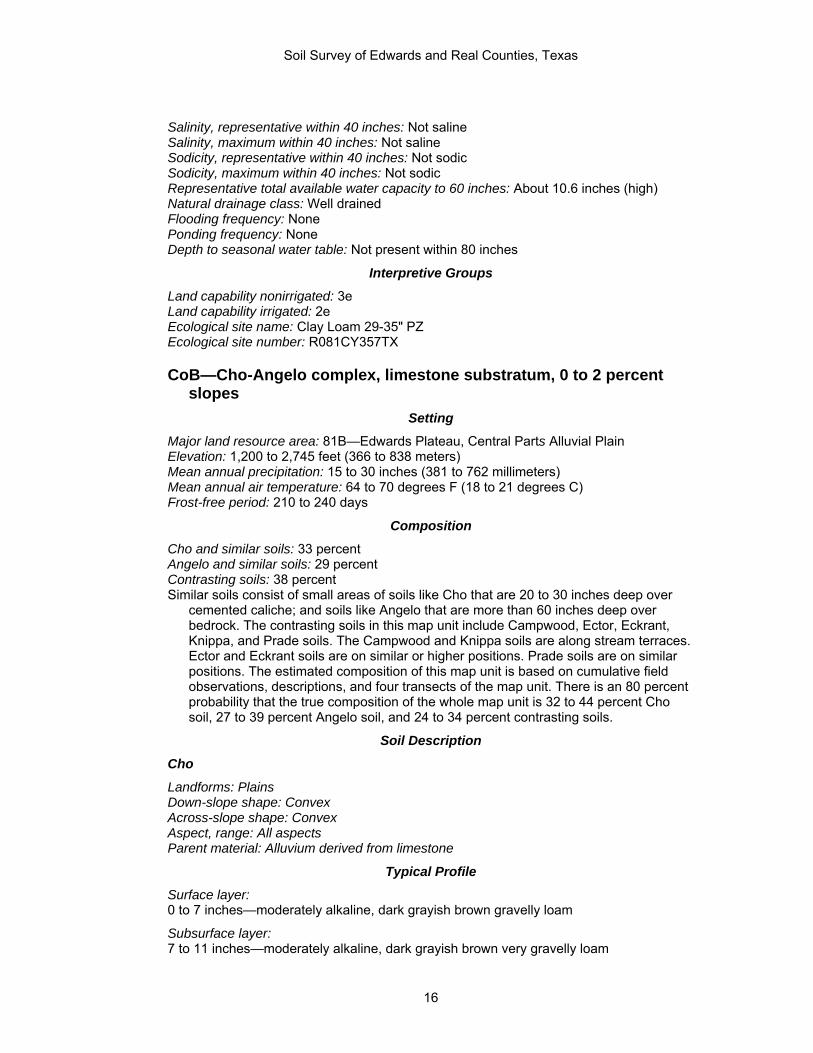
CoB—Cho-Angelo complex, limestone substratum, 0 to 2 percent slopes
Setting
Major land resource area: 81B—Edwards Plateau, Central Parts Alluvial Plain Elevation: 1,200 to 2,745 feet (366 to 838 meters) Mean annual precipitation: 15 to 30 inches (381 to 762 millimeters) Mean annual air temperature: 64 to 70 degrees F (18 to 21 degrees C) Frost-free period: 210 to 240 days
Composition
Cho and similar soils: 33 percent Angelo and similar soils: 29 percent Contrasting soils: 38 percent Similar soils consist of small areas of soils like Cho that are 20 to 30 inches deep over
cemented caliche; and soils like Angelo that are more than 60 inches deep over bedrock. The contrasting soils in this map unit include Campwood, Ector, Eckrant, Knippa, and Prade soils. The Campwood and Knippa soils are along stream terraces. Ector and Eckrant soils are on similar or higher positions. Prade soils are on similar positions. The estimated composition of this map unit is based on cumulative field observations, descriptions, and four transects of the map unit. There is an 80 percent probability that the true composition of the whole map unit is 32 to 44 percent Cho soil, 27 to 39 percent Angelo soil, and 24 to 34 percent contrasting soils.
Soil Description
Cho
Landforms: Plains Down-slope shape: Convex Across-slope shape: Convex Aspect, range: All aspects Parent material: Alluvium derived from limestone
Typical Profile
Surface layer: 0 to 7 inches—moderately alkaline, dark grayish brown gravelly loam
Subsurface layer: 7 to 11 inches—moderately alkaline, dark grayish brown very gravelly loam
16

Soil Survey of Edwards and Real Counties, Texas
Underlying material: 11 to 14 inches—moderately alkaline, strongly cemented caliche 14 to 24 inches—moderately alkaline, white and very pale brown weakly cemented caliche 24 to 80 inches—moderately alkaline, white and very pale brown gravelly silty clay loam
Properties and Qualities
Slope: 0 to 2 percent Percent of area covered by surface fragments: Not specified Depth to first restrictive layer: 7 to 20 inches (petrocalcic) Slowest soil permeability to 60 inches, above first cemented restrictive layer: 0.6 to 2.0
in/hr (moderate) Slowest permeability to 60 inches, within and below first cemented restrictive layer: 0.06
to 0.2 in/hr (slow) Salinity, representative within 40 inches: Not saline Salinity, maximum within 40 inches: Not saline Sodicity, representative within 40 inches: Not sodic Sodicity, maximum within 40 inches: Not sodic Representative total available water capacity to 60 inches: About 1.2 inches (very low) Natural drainage class: Well drained Flooding frequency: None Ponding frequency: None Depth to seasonal water table: Not present within 80 inches
Interpretive Groups
Land capability nonirrigated: 4s Land capability irrigated: Not assigned Ecological site name: Very Shallow 23-31" PZ Ecological site number: R081BY354TX
Angelo
Landforms: Plains Down-slope shape: Linear Across-slope shape: Linear Aspect, range: All aspects Parent material: Alluvium derived from limestone
Typical Profile
Surface layer: 0 to 12 inches—slightly alkaline, dark grayish brown silty clay loam
Subsoil: 12 to 25 inches—slightly alkaline, brown silty clay loam 25 to 37 inches—slightly alkaline, light yellowish brown clay loam 37 to 56 inches—slightly alkaline, reddish yellow clay loam
Underlying material: 56 to 80 inches—brown indurated limestone bedrock interbedded with strongly cemented
paralithic materials
Properties and Qualities
Slope: 0 to 1 percent Percent of area covered by surface fragments: Not specified Depth to first restrictive layer: 40 to 60 inches (lithic bedrock) Slowest soil permeability to 60 inches, above first cemented restrictive layer: 0.2 to 0.6
in/hr (moderately slow)
17

Soil Survey of Edwards and Real Counties, Texas
Slowest permeability to 60 inches, within and below first cemented restrictive layer: 0.06 to 0.2 in/hr (slow)
Salinity, representative within 40 inches: Not saline Salinity, maximum within 40 inches: Not saline Sodicity, representative within 40 inches: Not sodic Sodicity, maximum within 40 inches: Not sodic Representative total available water capacity to 60 inches: About 9.5 inches (high) Natural drainage class: Well drained Flooding frequency: None Ponding frequency: None Depth to seasonal water table: Not present within 80 inches
Interpretive Groups
Land capability nonirrigated: 3c Land capability irrigated: 1 Ecological site name: Clay Loam 19-23" PZ Ecological site number: R081BY325TX
DeB—Dev-Riverwash complex, 0 to 3 percent slopes, frequently flooded
Setting
Major land resource area: 81B—Edwards Plateau, Central Part Landscape: Dissected plateaus and river valleys (fig. 5) Elevation: 600 to 3,145 feet (183 to 960 meters) Mean annual precipitation: 8 to 35 inches (203 to 889 millimeters) Mean annual air temperature: 61 to 70 degrees F (16 to 21 degrees C) Frost-free period: 210 to 300 days
Composition
Dev and similar soils: 60 percent Riverwash and similar soils: 25 percent Contrasting soils: 15 percent Similar soils consist of small areas of soils like Dev that are not as gravelly, and are
occasionally flooded. The contrasting soils in this map unit include small areas of Dina, Ector, Eckrant, Mailtrail, Mereta, Nuvalde, Oplin, Prade, Rio Frio, Vanderpool, Tarrant, and Valera soils. The Mailtrail, Mereta, and Nuvalde soils are on stream terraces. The Rio Frio and Vanderpool soils are on flood plains, The Dina, Prade, Tarrant and Valera soils are higher plains. The Ector, Eckrant, and Oplin soils are on steep side slopes. The estimated composition of this map unit is based on cumulative field observations, descriptions, and one transect of the map unit. The estimated composition of the whole map unit is 54 to 66 percent Dev soil, 20 to 30 percent Riverwash, and 11 to 21 percent contrasting soils.
Soil Description
Dev
Landforms: Flood plains, flood plains on draws Down-slope shape: Linear Across-slope shape: Concave Aspect, range: All aspects Parent material: Alluvium derived from limestone
18

Soil Survey of Edwards and Real Counties, Texas
Figure 5.—The Frio River flowing through an area of Dev-Riverwash complex, 0 to 3 percent slopes, frequently flooded. Eckrant soils and Rock outcrop are on the steep slopes in the background.
Typical Profile
Surface layer: 0 to 6 inches—moderately alkaline, dark grayish brown very gravelly loam
Subsurface layer: 6 to 9 inches—moderately alkaline, dark grayish brown loam 9 to 37 inches—moderately alkaline, dark grayish brown very gravelly sandy loam
Underlying material: 37 to 52 inches—moderately alkaline, light yellowish brown extremely gravelly sand 52 to 62 inches—moderately alkaline, pale brown very cobbly sandy loam 62 to 80 inches—moderately alkaline, pale brown extremely cobbly sand
Properties and Qualities
Slope: 0 to 3 percent Percent of area covered by surface fragments: Not specified Depth to first restrictive layer: Not present Slowest soil permeability to 60 inches, above first cemented restrictive layer: 2.0 to 6.0
in/hr (moderately rapid) Slowest permeability to 60 inches, within and below first cemented restrictive layer: No
restrictive layer Salinity, representative within 40 inches: Not saline Salinity, maximum within 40 inches: Not saline Sodicity, representative within 40 inches: Not sodic Sodicity, maximum within 40 inches: Not sodic Representative total available water capacity to 60 inches: About 4.9 inches (low) Natural drainage class: Well drained
19

Soil Survey of Edwards and Real Counties, Texas
Flooding frequency: Frequent during April to September for brief duration Ponding frequency: None Depth to seasonal water table: Not present within 80 inches
Interpretive Groups
Land capability nonirrigated: 6w Land capability irrigated: Not assigned Ecological site name: Draw 19-31" PZ Ecological site number: R081BY682TX
Riverwash
Landforms: Channels Down-slope shape: Concave Across-slope shape: Concave Parent material: Gravelly alluvium derived from limestone
Properties and Qualities
Slope: 0 to 2 percent Percent of area covered by surface fragments: Not specified Depth to first restrictive layer: Not present Slowest soil permeability to 60 inches, above first cemented restrictive layer: 6.0 to 20
in/hr (rapid) Slowest permeability to 60 inches, within and below first cemented restrictive layer: No
restrictive layer Salinity, representative within 40 inches: Not saline Salinity, maximum within 40 inches: Not saline Sodicity, representative within 40 inches: Not sodic Sodicity, maximum within 40 inches: Not sodic Representative total available water capacity to 60 inches: About 1.8 inches (very low) Natural drainage class: Excessively drained Flooding frequency: Frequent during May to September for brief duration Ponding frequency: Not ponded Depth to seasonal water table: Not present within 80 inches
Interpretive Groups
Land capability nonirrigated: 8w Land capability irrigated: Not assigned Ecological site name: Not assigned Ecological site number: Not assigned
DnD—Dina-Eckrant complex, 1 to 8 percent slopes
Setting
Major land resource area: 81C—Edwards Plateau, Eastern Part Landscape: Dissected plateaus Elevation: 1,000 to 2,400 feet (305 to 732 meters) Mean annual precipitation: 22 to 32 inches (559 to 813 millimeters) Mean annual air temperature: 66 to 70 degrees F (19 to 21 degrees C) Frost-free period: 210 to 245 days
Composition
Dina and similar soils: 60 percent Eckrant and similar soils: 30 percent
20
Soil Survey of Edwards and Real Counties, Texas
Contrasting soils: 10 percent Similar soils consist of small areas of soils like Dina that are shallow and soils like
Eckrant that are moderately deep. The contrasting soils in this map unit include Dev, Ector, Oplin, and Valera soils. The Dev soils are on flood plains. The Ector and Oplin soils are on side slopes. The Valera soils are on similar or lower positions. The estimated composition of this map unit is based on cumulative field observations, descriptions, and one transect of the map unit. The estimated composition of the whole map unit is 54 to 66 percent Dina soil, 24 to 35 percent Eckrant soil, and 6 to 14 percent contrasting soils.
Soil Description
Dina
Landforms: Low ridges Geomorphic positions, two-dimensional: Summit, shoulder Geomorphic positions, three-dimensional: Interfluve Down-slope shape: Convex Across-slope shape: Convex Aspect, range: All aspects Parent material: Residuum weathered from limestone
Typical Profile
Surface layer: 0 to 3 inches—neutral, very dark gray and very dark grayish brown cobbly silty clay loam
Subsurface layer: 3 to 8 inches—neutral, brown and very dark gray cobbly silty clay loam
Subsoil: 8 to 14 inches—neutral, dark reddish brown, brown very stony clay 14 to 20 inches—neutral, dark reddish brown and brown very stony clay 20 to 26 inches—neutral, reddish brown very stony clay 26 to 31 inches—neutral, reddish brown extremely cobbly clay
Underlying material: 31 to 203 inches—light gray indurated bedrock, fractured
Properties and Qualities
Slope: 1 to 5 percent Percent of area covered by surface fragments: Not specified Depth to first restrictive layer: 20 to 40 inches (lithic bedrock) Slowest soil permeability to 60 inches, above first cemented restrictive layer: 0.2 to 0.6
in/hr (moderately slow) Slowest permeability to 60 inches, within and below first cemented restrictive layer: 0.2 to
0.6 in/hr (moderately slow) Salinity, representative within 40 inches: Not saline Salinity, maximum within 40 inches: Not saline Sodicity, representative within 40 inches: Not sodic Sodicity, maximum within 40 inches: Not sodic Representative total available water capacity to 60 inches: About 1.6 inches (very low) Natural drainage class: Well drained Flooding frequency: None Ponding frequency: None Depth to seasonal water table: Not present within 80 inches
21

Soil Survey of Edwards and Real Counties, Texas
Interpretive Groups
Land capability nonirrigated: 6s Land capability irrigated: Not assigned Ecological site name: Gravelly Redland 29-35" PZ Ecological site number: R081CY359TX
Eckrant
Landforms: Ridges Geomorphic positions, two-dimensional: Shoulder Geomorphic positions, three-dimensional: Side slope Down-slope shape: Convex Across-slope shape: Convex Aspect, range: All aspects Parent material: Residuum weathered from limestone
Typical Profile
Surface layer: 0 to 7 inches—slightly alkaline, very dark gray very cobbly silty clay
Subsurface layer: 7 to 16 inches—slightly alkaline, gray extremely stony silty clay
Underlying material: 16 to 80 inches—light gray indurated limestone bedrock
Properties and Qualities
Slope: 1 to 8 percent Percent of area covered by surface fragments: Not specified Depth to first restrictive layer: 8 to 20 inches (lithic bedrock) Slowest soil permeability to 60 inches, above first cemented restrictive layer: 0.2 to 0.6
in/hr (moderately slow) Slowest permeability to 60 inches, within and below first cemented restrictive layer: 0.06
to 0.2 in/hr (slow) Salinity, representative within 40 inches: Not saline Salinity, maximum within 40 inches: Not saline Sodicity, representative within 40 inches: Not sodic Sodicity, maximum within 40 inches: Not sodic Representative total available water capacity to 60 inches: About 1.5 inches (very low) Natural drainage class: Well drained Flooding frequency: None Ponding frequency: None Depth to seasonal water table: Not present within 80 inches
Interpretive Groups
Land capability nonirrigated: 7s Land capability irrigated: Not assigned Ecological site name: Low Stony Hill 29-35" PZ Ecological site number: R081CY360TX
EcF—Eckrant-Rock outcrop complex, 1 to 20 percent slopes
Setting
Major land resource area: 81B—Edwards Plateau, Central Part Landscape: Dissected plateaus
22

Soil Survey of Edwards and Real Counties, Texas
Elevation: 1,000 to 2,400 feet (305 to 732 meters) Mean annual precipitation: 10 to 35 inches (254 to 889 millimeters) Mean annual air temperature: 52 to 73 degrees F (11 to 23 degrees C) Frost-free period: 120 to 320 days
Composition
Eckrant and similar soils: 67 percent Rock outcrop and similar soils: 13 percent Contrasting soils: 20 percent Similar soils in this map unit include small areas of Eckrant that are moderately deep, and
Tarrant soils. The contrasting soils in this map unit are Dev, Dina, Nuvalde, Oplin, and Valera soils. The Dev soils are on flood plains. The Dina and Oplin soils are on similar positions. The Nuvalde soils are on stream terraces. The Valera soils are on lower positions on plains. The estimated composition of this map unit is based on cumulative field observations, descriptions, and three transects of the map unit. There is an 80 percent probability that the true composition of the whole map unit is 61 to 73 percent Eckrant soil, 9 to 17 percent Rock outcrop, and 15 to 25 percent contrasting soils.
Soil Description
Eckrant
Landforms: Ridges Geomorphic positions, two-dimensional: Shoulder, footslope Geomorphic positions, three-dimensional: Base slope, side slope Down-slope shape: Convex Across-slope shape: Convex Aspect, range: All aspects Parent material: Residuum weathered from limestone
Typical Profile
Surface layer: 0 to 9 inches—slightly alkaline, black very cobbly silty clay
Underlying material: 9 to 80 inches—pale yellow, indurated limestone bedrock
Properties and Qualities
Slope: 1 to 20 percent Percent of area covered by surface fragments: Not specified Depth to first restrictive layer: 8 to 20 inches (lithic bedrock) Slowest soil permeability to 60 inches, above first cemented restrictive layer: 0.2 to 0.6
in/hr (moderately slow) Slowest permeability to 60 inches, within and below first cemented restrictive layer: 0.06
to 0.2 in/hr (slow) Salinity, representative within 40 inches: Not saline Salinity, maximum within 40 inches: Not saline Sodicity, representative within 40 inches: Not sodic Sodicity, maximum within 40 inches: Not sodic Representative total available water capacity to 60 inches: About 0.8 inch (very low) Natural drainage class: Well drained Flooding frequency: None Ponding frequency: None Depth to seasonal water table: Not present within 80 inches
23

Soil Survey of Edwards and Real Counties, Texas
Interpretive Groups
Land capability nonirrigated: 7s Land capability irrigated: Not assigned Ecological site name: Low Stony Hill 23-31" PZ Ecological site number: R081BY337TX
Rock outcrop
Landforms: Ridges Geomorphic positions, two-dimensional: Footslope, shoulder Geomorphic positions, three-dimensional: Base slope, side slope Down-slope shape: Convex Across-slope shape: Convex Parent material: Limestone
Properties and Qualities
Slope: 1 to 20 percent Percent of area covered by surface fragments: Not specified Depth to first restrictive layer: 0 to 2 inches (lithic bedrock) Slowest soil permeability to 60 inches, above first cemented restrictive layer: Not
specified Slowest permeability to 60 inches, within and below first cemented restrictive layer: 0.06
to 0.2 in/hr (slow) Salinity, representative within 40 inches: Not saline Salinity, maximum within 40 inches: Not saline Sodicity, representative within 40 inches: Not sodic Sodicity, maximum within 40 inches: Not sodic Representative total available water capacity to 60 inches: About 0.5 (very low) Natural drainage class: Not specified Flooding frequency: None Ponding frequency: None Depth to seasonal water table: Not present within 80 inches
Interpretive Groups
Land capability nonirrigated: 8s Land capability irrigated: Not assigned Ecological site name: Not assigned Ecological site number: Not assigned
EcG—Eckrant-Rock outcrop complex, 20 to 60 percent slopes
Setting
Major land resource area: 81C—Edwards Plateau, Eastern Part Landscape: Dissected plateaus Elevation: 1,000 to 2,400 feet (305 to 732 meters) Mean annual precipitation: 10 to 35 inches (254 to 889 millimeters) Mean annual air temperature: 52 to 73 degrees F (11 to 23 degrees C) Frost-free period: 120 to 320 days
Composition
Eckrant and similar soils: 50 percent Rock outcrop and similar soils: 33 percent Contrasting soils: 17 percent
24

Soil Survey of Edwards and Real Counties, Texas
Similar soils consist of small areas of Eckrant that are moderately deep, and Tarrant soils. The contrasting soils in this map unit include small areas of Dev, Dina, Campwood, Knippa, Leakey, Oplin, and Real. The Dev soils are on flood plains. The Campwood, Leakey, and Knippa soils are on stream terraces. The Dina, Oplin, and Real soils are on similar positions. The estimated composition of this map unit is based on cumulative field observations, descriptions, and three transects of the map unit. There is an 80 percent probability that the true composition of the whole map unit is 44 to 56 percent Eckrant soil, 27 to 39 percent Rock outcrop, and 12 to 22 percent contrasting soils.
Soil Description
Eckrant
Landforms: Ridges Geomorphic positions, two-dimensional: Backslope, footslope Geomorphic positions, three-dimensional: Base slope, side slope Down-slope shape: Convex Across-slope shape: Convex Aspect, range: All aspects Parent material: Residuum weathered from limestone
Typical Profile
Surface layer: 0 to 2 inches—very dark grayish brown and white cobbly partially decomposed organic matter 2 to 11 inches—slightly alkaline, very dark gray very cobbly silty clay
Underlying material: 11 to 80 inches—light brownish gray indurated bedrock
Properties and Qualities
Slope: 20 to 60 percent Percent of area covered by surface fragments: Not specified Depth to first restrictive layer: 8 to 20 inches (lithic bedrock) Slowest soil permeability to 60 inches, above first cemented restrictive layer: 0.2 to 0.6
in/hr (moderately slow) Slowest permeability to 60 inches, within and below first cemented restrictive layer: 0.06
to 0.2 in/hr (slow) Salinity, representative within 40 inches: Not saline Salinity, maximum within 40 inches: Not saline Sodicity, representative within 40 inches: Not sodic Sodicity, maximum within 40 inches: Not sodic Representative total available water capacity to 60 inches: About 0.9 inch (very low) Natural drainage class: Well drained Flooding frequency: None Ponding frequency: None Depth to seasonal water table: Not present within 80 inches
Interpretive Groups
Land capability nonirrigated: 7s Land capability irrigated: Not assigned Ecological site name: Steep Rocky 29-35" PZ Ecological site number: R081CY363TX
Rock outcrop
Landforms: Ridges Geomorphic positions, two-dimensional: Backslope, footslope
25

Soil Survey of Edwards and Real Counties, Texas
Geomorphic positions, three-dimensional: Base slope, side slope Down-slope shape: Convex Across-slope shape: Convex Parent material: Limestone
Properties and Qualities
Slope: 20 to 60 percent Percent of area covered by surface fragments: Not specified Depth to first restrictive layer: 0 to 2 inches (lithic bedrock) Slowest soil permeability to 60 inches, above first cemented restrictive layer: Not specified Slowest permeability to 60 inches, within and below first cemented restrictive layer: 0.06
to 0.2 in/hr (slow) Salinity, representative within 40 inches: Not saline Salinity, maximum within 40 inches: Not saline Sodicity, representative within 40 inches: Not sodic Sodicity, maximum within 40 inches: Not sodic Representative total available water capacity to 60 inches: About 0.5 inch (very low) Natural drainage class: Not specified Flooding frequency: None Ponding frequency: None Depth to seasonal water table: Not present within 80 inches
Interpretive Groups
Land capability nonirrigated: 8s Land capability irrigated: Not assigned Ecological site name: Not assigned Ecological site number: Not assigned
ErB—Ector gravelly silty clay loam, 1 to 3 percent slopes
Setting
Major land resource area: 81A—Edwards Plateau, Western Part Landscape: Dissected plateaus Elevation: 1,745 to 2,745 feet (533 to 838 meters) Mean annual precipitation: 12 to 20 inches (305 to 508 millimeters) Mean annual air temperature: 63 to 70 degrees F (17 to 21 degrees C) Frost-free period: 220 to 240 days
Composition
Ector taxadjunct and similar soils: 90 percent Contrasting soils: 10 percent Similar soils consists of small of areas of soils like Ector that are less gravelly. The
contrasting soils in this map unit include small areas of Angelo, Campwood, Knippa, Irion, and Valera soils. The Irion soils are in depressions. The Angelo, Campwood, Knippa, and Valera soils are on similar or lower positions. The estimated composition of this map unit is based on cumulative field observations, descriptions, and one transect of the map unit. The estimated composition of the whole map unit is 86 to 94 percent Ector soil, 6 to 14 percent contrasting soils.
Soil Description
Ector
Landforms: Low hills Geomorphic positions, two-dimensional: Summit, shoulder, backslope
26
Soil Survey of Edwards and Real Counties, Texas
Geomorphic positions, three-dimensional: Mountainflank, mountaintop Down-slope shape: Convex Across-slope shape: Convex Aspect, range: All aspects Parent material: Loamy residuum weathered from limestone
Typical Profile
Surface layer: 0 to 3 inches—moderately alkaline, dark grayish brown gravelly silty clay loam
Subsurface layer: 3 to 7 inches—moderately alkaline, dark grayish brown extremely gravelly silty clay loam
Underlying material: 7 to 80 inches—moderately alkaline, white and yellowish brown unweathered indurated
bedrock
Properties and Qualities
Slope: 1 to 3 percent Percent of area covered by surface fragments: Not specified Depth to first restrictive layer: 4 to 20 inches (lithic bedrock) Slowest soil permeability to 60 inches, above first cemented restrictive layer: 0.6 to 2.0
in/hr (moderate) Slowest permeability to 60 inches, within and below first cemented restrictive layer: 0.06
to 0.2 in/hr (slow) Salinity, representative within 40 inches: Not saline Salinity, maximum within 40 inches: Not saline Sodicity, representative within 40 inches: Not sodic Sodicity, maximum within 40 inches: Not sodic Representative total available water capacity to 60 inches: About 0.5 inch (very low) Natural drainage class: Well drained Flooding frequency: None Ponding frequency: None Depth to seasonal water table: Not present within 80 inches
Interpretive Groups
Land capability nonirrigated: 7s Land capability irrigated: Not assigned Ecological site name: Limestone Hill 19-23" PZ Ecological site number: R081BY593TX
ErF—Ector-Rock outcrop complex, 1 to 20 percent slopes
Setting
Major land resource area: 81A—Edwards Plateau, Western Part Landscape: Dissected plateaus Elevation: 1,600 to 2,745 feet (488 to 838 meters) Mean annual precipitation: 10 to 35 inches (254 to 889 millimeters) Mean annual air temperature: 52 to 73 degrees F (11 to 23 degrees C) Frost-free period: 120 to 320 days
Composition
Ector and similar soils: 71 percent Rock outcrop and similar soils: 16 percent Contrasting soils: 13 percent
27
Soil Survey of Edwards and Real Counties, Texas
Similar soils consist of small areas of soils like Ector that are moderately deep and Zorra soils. The contrasting soils in this map unit include small areas of Dev, Eckrant, Oplin, Mailtrail, and Rio Diablo soils. The Dev and Rio Diablo soils are on flood plains. Eckrant and Oplin soils are on similar positions. Mailtrail soils are on lower positions. The estimated composition of this map unit is based on cumulative field observations, descriptions, and six transects of the map unit. There is an 80 percent probability that the true composition of the whole map unit is 66 to 76 percent Ector soil, 12 to 20 percent Rock outcrop, and 9 to 17 percent contrasting soils.
Soil Description
Ector
Landforms: Ridges Geomorphic positions, two-dimensional: Backslope, footslope Geomorphic positions, three-dimensional: Mountainflank, mountaintop, crest Down-slope shape: Convex Across-slope shape: Convex Aspect, range: All aspects Parent material: Loamy residuum weathered from limestone
Typical Profile
Surface layer: 0 to 8 inches—moderately alkaline grayish brown very cobbly loam
Underlying material: 8 to 80 inches—indurated limestone bedrock
Properties and Qualities
Slope: 1 to 20 percent Percent of area covered by surface fragments: Not specified Depth to first restrictive layer: 4 to 20 inches (lithic bedrock) Slowest soil permeability to 60 inches, above first cemented restrictive layer: 0.6 to 2.0
in/hr (moderate) Slowest permeability to 60 inches, within and below first cemented restrictive layer: 0.06
to 0.2 in/hr (slow) Salinity, representative within 40 inches: Not saline Salinity, maximum within 40 inches: Not saline Sodicity, representative within 40 inches: Not sodic Sodicity, maximum within 40 inches: Not sodic Representative total available water capacity to 60 inches: About 0.7 inch (very low) Natural drainage class: Well drained Flooding frequency: None Ponding frequency: None Depth to seasonal water table: Not present within 80 inches
Interpretive Groups
Land capability nonirrigated: 7s Land capability irrigated: Not assigned Ecological site name: Limestone Hill 19-23" PZ Ecological site number: R081BY593TX
Rock outcrop
Landforms: Ridges Geomorphic positions, two-dimensional: Backslope, footslope Geomorphic positions, three-dimensional: Mountainflank, mountaintop, crest
28

Soil Survey of Edwards and Real Counties, Texas
Down-slope shape: Convex Across-slope shape: Convex Parent material: Limestone
Properties and Qualities
Slope: 1 to 20 percent Percent of area covered by surface fragments: Not specified Depth to first restrictive layer: 0 to 2 inches (lithic bedrock) Slowest soil permeability to 60 inches, above first cemented restrictive layer: Not
specified Slowest permeability to 60 inches, within and below first cemented restrictive layer: 0.06
to 0.2 in/hr (slow) Salinity, representative within 40 inches: Not saline Salinity, maximum within 40 inches: Not saline Sodicity, representative within 40 inches: Not sodic Sodicity, maximum within 40 inches: Not sodic Representative total available water capacity to 60 inches: About 0.5 inch (very low) Natural drainage class: Not specified Flooding frequency: None Ponding frequency: None Depth to seasonal water table: Not present within 80 inches
Interpretive Groups
Land capability nonirrigated: 8s Land capability irrigated: Not assigned Ecological site name: Not assigned Ecological site number: Not assigned
ErG—Ector-Rock outcrop complex, 20 to 60 percent slopes
Setting
Major land resource area: 81A—Edwards Plateau, Western Part Landscape: Dissected plateaus Elevation: 1,600 to 2,745 feet (488 to 838 meters) Mean annual precipitation: 10 to 35 inches (254 to 889 millimeters) Mean annual air temperature: 52 to 73 degrees F (11 to 23 degrees C) Frost-free period: 120 to 320 days
Composition
Ector and similar soils: 61 percent Rock outcrop and similar soils: 35 percent Contrasting soils: 4 percent Similar soils consist of small areas of soils like Ector that are moderately deep and Zorra
soils. The contrasting soils in this map unit include small areas of Dev, Eckrant, Mailtrail, Oplin, and Rio Diablo soils. The Dev and Rio Diablo soils are on flood plains. The Eckrant and Oplin soils are on similar positions. The Mailtrail soils are on lower positions. The estimated composition of this map unit is based on cumulative field observations, descriptions, and six transects of the map unit. There is an 80 percent probability that the true composition of the whole map unit is 55 to 67 percent Ector soil, 29 to 41 percent Rock outcrop, and 2 to 6 percent contrasting soils.
29

Soil Survey of Edwards and Real Counties, Texas
Soil Description
Ector
Landforms: Ridges Geomorphic positions, two-dimensional: Backslope, footslope Geomorphic positions, three-dimensional: Mountainflank, mountaintop, crest Down-slope shape: Convex Across-slope shape: Convex Aspect, range: All aspects Parent material: Loamy residuum weathered from limestone
Typical Profile
Surface layer: 0 to 12 inches—moderately alkaline, grayish brown very cobbly loam
Underlying material: 12 to 80 inches—indurated limestone bedrock
Properties and Qualities
Slope: 20 to 40 percent Percent of area covered by surface fragments: Not specified Depth to first restrictive layer: 4 to 20 inches (lithic bedrock) Slowest soil permeability to 60 inches, above first cemented restrictive layer: 0.6 to 2.0
in/hr (moderate) Slowest permeability to 60 inches, within and below first cemented restrictive layer: 0.06
to 0.2 in/hr (slow) Salinity, representative within 40 inches: Not saline Salinity, maximum within 40 inches: Not saline Sodicity, representative within 40 inches: Not sodic Sodicity, maximum within 40 inches: Not sodic Representative total available water capacity to 60 inches: About 1.1 inches (very low) Natural drainage class: Well drained Flooding frequency: None Ponding frequency: None Depth to seasonal water table: Not present within 80 inches
Interpretive Groups
Land capability nonirrigated: 7s Land capability irrigated: Not assigned Ecological site name: Steep Rocky 19-23" PZ Ecological site number: R081BY349TX
Rock outcrop
Landforms: Ridges Geomorphic positions, two-dimensional: Backslope, footslope Geomorphic positions, three-dimensional: Mountainflank, mountaintop, crest Down-slope shape: Convex Across-slope shape: Convex Parent material: Limestone
Properties and Qualities
Slope: 20 to 60 percent Percent of area covered by surface fragments: Not specified Depth to first restrictive layer: 0 to 2 inches (lithic bedrock)
30

Soil Survey of Edwards and Real Counties, Texas
Slowest soil permeability to 60 inches, above first cemented restrictive layer: Not specified Slowest permeability to 60 inches, within and below first cemented restrictive layer: 0.06
to 0.2 in/hr (slow) Salinity, representative within 40 inches: Not saline Salinity, maximum within 40 inches: Not saline Sodicity, representative within 40 inches: Not sodic Sodicity, maximum within 40 inches: Not sodic Representative total available water capacity to 60 inches: About 0.5 inch (very low) Natural drainage class: Not specified Flooding frequency: None Ponding frequency: None Depth to seasonal water table: Not present within 80 inches
Interpretive Groups
Land capability nonirrigated: 8s Land capability irrigated: Not assigned Ecological site name: Not assigned Ecological site number: Not assigned
IrA—Irion clay, 0 to 1 percent slopes
Setting
Major land resource area: 81B—Edwards Plateau, Central Part Landscape: Dissected plateaus Elevation: 2,280 to 2,735 feet (695 to 835 meters) Mean annual precipitation: 14 to 22 inches (356 to 559 millimeters) Mean annual air temperature: 64 to 70 degrees F (18 to 21 degrees C) Frost-free period: 220 to 240 days
Composition
Irion and similar soils: 90 percent Contrasting soils: 10 percent Similar soils consist of small areas of soils like Irion with limestone bedrock at 40 to 60
inches. The contrasting soils in this map unit include small areas of Angelo, Cho, Eckrant, Ector, Harper, Prade, Tarrant, and Valera soils. All of these soils are on higher positions. The estimated composition of this map unit is based on cumulative field observations, descriptions, and two transects of the map unit. There is an 80 percent probability that the true composition of the whole map unit is 85 to 95 percent Irion soil, and 5 to 15 percent contrasting soils.
Soil Description
Irion
Landforms: Depressions Down-slope shape: Concave Across-slope shape: Concave Aspect, range: All aspects Parent material: Alluvium derived from limestone
Typical Profile
Surface layer: 0 to 14 inches—moderately alkaline, very dark grayish brown clay
Subsoil: 14 to 54 inches— moderately alkaline, very dark grayish brown clay
31

Soil Survey of Edwards and Real Counties, Texas
54 to 72 inches— moderately alkaline, dark grayish brown clay
Underlying material: 72 to 80 inches—indurated limestone bedrock
Properties and Qualities
Slope: 0 to 1 percent Percent of area covered by surface fragments: Not specified Depth to first restrictive layer: 60 to 80 inches (lithic bedrock) Slowest soil permeability to 60 inches, above first cemented restrictive layer: 0.001 to
0.06 in/hr (very slow) Slowest permeability to 60 inches, within and below first cemented restrictive layer: No
restrictive layer Salinity, representative within 40 inches: Not saline Salinity, maximum within 40 inches: Not saline Sodicity, representative within 40 inches: Not sodic Sodicity, maximum within 40 inches: Not sodic Representative total available water capacity to 60 inches: About 9.0 inches (high) Natural drainage class: Well drained Flooding frequency: None Ponding frequency: Occasional during May to November for long periods Depth to seasonal water table: Not present within 80 inches
Interpretive Groups
Land capability nonirrigated: 2s Land capability irrigated: Not assigned Ecological site name: Clay Flat 14-19" PZ Ecological site number: R081AY290TX
KrD—Kerrville-Real complex, 1 to 8 percent slopes
Setting
Major land resource area: 81C—Edwards Plateau, Eastern Part Landscape: Dissected plateaus Elevation: 1,000 to 2,095 feet (305 to 640 meters) Mean annual precipitation: 22 to 34 inches (559 to 864 millimeters) Mean annual air temperature: 64 to 70 degrees F (18 to 21 degrees C) Frost-free period: 220 to 250 days
Composition
Kerrville and similar soils: 54 percent Real and similar soils: 26 percent Contrasting soils: 20 percent Similar soils consist of small areas of soils like Kerrville that are shallow over limestone
bedrock. The contrasting soils in this map unit include small areas of Dev, Campwood, Ector, Knippa, Mailtrail, Mereta, Oakalla, Orif, Pratley, and Real soils, and Riverwash. The Dev, Oakalla, Orif, and Riverwash are on flood plains. The Campwood, Knippa, Mailtrail, and Mereta soils are on stream terraces. The Ector and Real soils are on similar positions. The Pratley soils are on lower positions. The estimated composition of this map unit is based on cumulative field observations, descriptions, and three transects of the map unit. There is an 80 percent probability that the true composition of the whole map unit is 48 to 60 percent Kerrville soil, 20 to 32 percent Real soil, and 15 to 25 percent contrasting soils.
32

Soil Survey of Edwards and Real Counties, Texas
Soil Description
Kerrville
Landforms: Ridges Geomorphic positions, two-dimensional: Shoulder, summit Geomorphic positions, three-dimensional: Side slope, interfluve Down-slope shape: Convex Across-slope shape: Convex Aspect, range: All aspects Parent material: Residuum weathered from limestone
Typical Profile
Surface layer: 0 to 5 inches—moderately alkaline, pale brown, gravelly silt loam
Subsoil: 5 to 33 inches—moderately alkaline, pale brown, very paracobbly clay loam
Underlying material: 33 to 48 inches—strongly cemented limestone bedrock
Properties and Qualities
Slope: 1 to 8 percent Percent of area covered by surface fragments: Not specified Depth to first restrictive layer: 20 to 40 inches (lithic bedrock) Slowest soil permeability to 60 inches, above first cemented restrictive layer: 0.6 to 2.0
in/hr (moderate) Slowest permeability to 60 inches, within and below first cemented restrictive layer: 0.06
to 0.2 in/hr (slow) Salinity, representative within 40 inches: Not saline Salinity, maximum within 40 inches: Not saline Sodicity, representative within 40 inches: Not sodic Sodicity, maximum within 40 inches: Not sodic Representative total available water capacity to 60 inches: About 2.3 inches (very low) Natural drainage class: Well drained Flooding frequency: None Ponding frequency: None Depth to seasonal water table: Not present within 80 inches
Interpretive Groups
Land capability nonirrigated: 4e Land capability irrigated: Not assigned Ecological site name: Adobe 29-35" PZ Ecological site number: R081CY355TX
Real
Landforms: Ridges Geomorphic positions, two-dimensional: Backslope, footslope Geomorphic positions, three-dimensional: Base slope, side slope Down-slope shape: Convex Across-slope shape: Convex Aspect, range: All aspects Parent material: Residuum weathered from limestone
33

Soil Survey of Edwards and Real Counties, Texas
Typical Profile
Surface layer: 0 to 6 inches—moderately alkaline, dark grayish brown, very cobbly clay loam
Subsurface layer: 6 to 9 inches—moderately alkaline, dark grayish brown, extremely cobbly clay loam
Underlying material: 9 to 80 inches—moderately cemented bedrock
Properties and Qualities
Slope: 1 to 8 percent Percent of area covered by surface fragments: Not specified Depth to first restrictive layer: 8 to 20 inches (paralithic bedrock) Slowest soil permeability to 60 inches, above first cemented restrictive layer: 0.6 to 2.0
in/hr (moderate) Slowest permeability to 60 inches, within and below first cemented restrictive layer: 0.2 to
0.6 in/hr (moderately slow) Salinity, representative within 40 inches: Not saline Salinity, maximum within 40 inches: Not saline Sodicity, representative within 40 inches: Not sodic Sodicity, maximum within 40 inches: Not sodic Representative total available water capacity to 60 inches: About 0.7 inch (very low) Natural drainage class: Well drained Flooding frequency: None Ponding frequency: None Depth to seasonal water table: Not present within 80 inches
Interpretive Groups
Land capability nonirrigated: 6s Land capability irrigated: Not assigned Ecological site name: Adobe 29-35" PZ Ecological site number: R081CY355TX
KrF—Kerrville-Real complex, 8 to 40 percent slopes
Setting
Major land resource area: 81C—Edwards Plateau, Eastern Part Landscape: Dissected plateaus Elevation: 1,000 to 2,095 feet (305 to 640 meters) Mean annual precipitation: 22 to 34 inches (559 to 864 millimeters) Mean annual air temperature: 64 to 70 degrees F (18 to 21 degrees C) Frost-free period: 220 to 250 days
Composition
Kerrville and similar soils: 60 percent Real and similar soils: 21 percent Contrasting soils: 19 percent Similar soils consist of small areas of soils like Kerrville that are shallow over limestone
bedrock. The contrasting soils in this map unit include small areas of Campwood, Dev, Ector, Knippa, Mailtrail, Mereta, Oakalla, Orif, and Pratley soils, and Riverwash. The Dev, Oakalla, Orif, and Riverwash are on flood plains. The Campwood, Knippa, Mailtrail, and Mereta soils are on stream terraces. The Ector soils are on similar positions. The Pratley soils are on lower positions. The estimated composition of this
34

Soil Survey of Edwards and Real Counties, Texas
map unit is based on cumulative field observations, descriptions, and three transects of the map unit. There is an 80 percent probability that the true composition of the whole map unit is 54 to 66 percent Kerrville soil, 14 to 26 percent Real soil, and 14 to 24 percent contrasting soils.
Soil Description
Kerrville
Landforms: Ridges Geomorphic positions, two-dimensional: Backslope, footslope Geomorphic positions, three-dimensional: Side slope, base slope Down-slope shape: Convex Across-slope shape: Convex Aspect, range: All aspects Parent material: Residuum weathered from limestone
Typical Profile
Surface layer: 0 to 6 inches—moderately alkaline, light brownish gray gravelly silt loam
Subsoil: 6 to 14 inches—moderately alkaline, pale yellow very paragravelly silty clay loam 14 to 19 inches—moderately alkaline, pale yellow and light yellowish brown very
paragravelly silty clay loam 19 to 36 inches—moderately alkaline, white and light yellowish brown very paragravelly
silty clay loam
Underlying material: 36 to 48 inches—white strongly cemented limestone bedrock
Properties and Qualities
Slope: 8 to 40 percent Percent of area covered by surface fragments: Not specified Depth to first restrictive layer: 20 to 40 inches (lithic bedrock) Slowest soil permeability to 60 inches, above first cemented restrictive layer: 0.6 to 2.0
in/hr (moderate) Slowest permeability to 60 inches, within and below first cemented restrictive layer: 0.06
to 0.2 in/hr (slow) Salinity, representative within 40 inches: Not saline Salinity, maximum within 40 inches: Not saline Sodicity, representative within 40 inches: Not sodic Sodicity, maximum within 40 inches: Not sodic Representative total available water capacity to 60 inches: About 3.5 inches (low) Natural drainage class: Well drained Flooding frequency: None Ponding frequency: None Depth to seasonal water table: Not present within 80 inches
Interpretive Groups
Land capability nonirrigated: 7s Land capability irrigated: Not assigned Ecological site name: Steep Adobe 29-35" PZ Ecological site number: R081CY362TX
Real
Landforms: Ridges
35

Soil Survey of Edwards and Real Counties, Texas
Geomorphic positions, two-dimensional: Backslope, footslope Geomorphic positions, three-dimensional: Base slope, side slope Down-slope shape: Convex Across-slope shape: Convex Aspect, range: All aspects Parent material: Residuum weathered from limestone
Typical Profile
Surface layer: 0 to 10 inches—moderately alkaline, dark grayish brown, very cobbly clay loam
Underlying material: 10 to 13 inches—moderately cemented limestone bedrock 13 to 80 inches—weakly cemented limestone bedrock
Properties and Qualities
Slope: 8 to 40 percent Percent of area covered by surface fragments: Not specified Depth to first restrictive layer: 8 to 20 inches (paralithic bedrock) Slowest soil permeability to 60 inches, above first cemented restrictive layer: 0.6 to 2.0
in/hr (moderate) Slowest permeability to 60 inches, within and below first cemented restrictive layer: 0.2 to
0.6 in/hr (moderately slow) Salinity, representative within 40 inches: Not saline Salinity, maximum within 40 inches: Not saline Sodicity, representative within 40 inches: Not sodic Sodicity, maximum within 40 inches: Not sodic Representative total available water capacity to 60 inches: About 0.8 inch (very low) Natural drainage class: Well drained Flooding frequency: None Ponding frequency: None Depth to seasonal water table: Not present within 80 inches
Interpretive Groups
Land capability nonirrigated: 7s Land capability irrigated: Not assigned Ecological site name: Steep Adobe 29-35" PZ Ecological site number: R081CY362TX
LaE—Langtry-Rock outcrop complex, 1 to 15 percent slopes
Setting
Major land resource area: 81A—Edwards Plateau, Western Part Landscape: Dissected plateaus Elevation: 895 to 2,250 feet (274 to 686 meters) Mean annual precipitation: 10 to 35 inches (254 to 889 millimeters) Mean annual air temperature: 52 to 73 degrees F (11 to 23 degrees C) Frost-free period: 120 to 320 days
Composition
Langtry and similar soils: 72 percent Rock outcrop and similar soils: 10 percent Contrasting soils: 18 percent
36

Soil Survey of Edwards and Real Counties, Texas
Similar soils consist of small areas of soils like Langtry that are very gravelly, or very stony in the surface layer. Also included are small areas of soils less than 2 inches thick over limestone bedrock that are like Rock outcrop. Included are small areas of soils like these with slopes of 15 to 30 percent. The contrasting soils in this map unit include small areas of Dev, Ector, Mailtrail, Tarrant, and Rio Diablo soils, and Riverwash. The Dev and Rio Diablo soils, and Riverwash are on lower positions. The other soils are on similar positions on the landscape to Langtry and Rock outcrop. The estimated composition of this map unit is based on cumulative field observations, descriptions, and four transects of the map unit. There is an 80 percent probability that the true composition of the whole map unit is 67 to 77 percent Langtry soil, 7 to 13 percent Rock outcrop, and 13 to 23 percent contrasting soils.
Soil Description
Langtry
Landforms: Ridges Geomorphic positions, two-dimensional: Backslope, footslope Geomorphic positions, three-dimensional: Crest Down-slope shape: Convex Across-slope shape: Convex Aspect, range: All aspects Parent material: Residuum weathered from limestone
Typical Profile
Surface layer: 0 to 8 inches— moderately alkaline, dark grayish brown very cobbly silt loam
Subsurface layer: 8 to 14 inches— moderately alkaline, dark grayish brown extremely cobbly silt loam
Underlying material: 14 to 80 inches—indurated limestone bedrock
Properties and Qualities
Slope: 1 to 15 percent Percent of area covered by surface fragments: Not specified Depth to first restrictive layer: 4 to 20 inches (lithic bedrock) Slowest soil permeability to 60 inches, above first cemented restrictive layer: 0.6 to 2.0
in/hr (moderate) Slowest permeability to 60 inches, within and below first cemented restrictive layer: 0.06
to 0.2 in/hr (slow) Salinity, representative within 40 inches: Not saline Salinity, maximum within 40 inches: Not saline Sodicity, representative within 40 inches: Not sodic Sodicity, maximum within 40 inches: Not sodic Representative total available water capacity to 60 inches: About 0.6 inch (very low) Natural drainage class: Well drained Flooding frequency: None Ponding frequency: None Depth to seasonal water table: Not present within 80 inches
Interpretive Groups
Land capability nonirrigated: 7s Land capability irrigated: Not assigned Ecological site name: Limestone Hill 14-19" PZ Ecological site number: R081AY566TX
37
Soil Survey of Edwards and Real Counties, Texas
Rock outcrop
Landforms: Ridges Geomorphic positions, two-dimensional: Backslope, footslope Geomorphic positions, three-dimensional: Crest Down-slope shape: Convex Across-slope shape: Convex Parent material: Limestone
Properties and Qualities
Slope: 1 to 15 percent Percent of area covered by surface fragments: Not specified Depth to first restrictive layer: 0 to 2 inches (lithic bedrock) Slowest soil permeability to 60 inches, above first cemented restrictive layer: Not specified Slowest permeability to 60 inches, within and below first cemented restrictive layer: 0.06
to 0.2 in/hr (slow) Salinity, representative within 40 inches: Not saline Salinity, maximum within 40 inches: Not saline Sodicity, representative within 40 inches: Not sodic Sodicity, maximum within 40 inches: Not sodic Representative total available water capacity to 60 inches: About 0.5 inch (very low) Natural drainage class: Not specified Flooding frequency: None Ponding frequency: None Depth to seasonal water table: Not present within 80 inches
Interpretive Groups
Land capability nonirrigated: 8s Land capability irrigated: Not assigned Ecological site name: Not assigned Ecological site number: Not assigned
LkB—Leakey silty clay loam, 1 to 3 percent slopes
Setting
Major land resource area: 81C—Edwards Plateau, Eastern Part Landscape: River valleys Elevation: 1,000 to 2,000 feet (305 to 610 meters) Mean annual precipitation: 26 to 32 inches (660 to 813 millimeters) Mean annual air temperature: 64 to 70 degrees F (18 to 21 degrees C) Frost-free period: 220 to 240 days
Composition
Leakey and similar soils: 73 percent Contrasting soils: 27 percent Similar soils consist of small areas of soils like Leakey that are clay loam, gravelly clay, or
gravelly clay loam in the surface layer. Also included are small areas of soils like these with slopes of 5 to 8 percent. The contrasting soils in this map unit include small areas of Campwood, Dev, Eckrant, Knippa, Mailtrail, Mereta, Oplin, Real, and Tarpley soils, and Riverwash. The Dev soils and Riverwash are on flood plains. The Campwood, Knippa, Mailtrail, and Mereta soils are on stream terraces. The Tarpley soils are on similar positions. The Oplin, Real, and Eckrant soils are on higher positions. The estimated composition of this map unit is based on cumulative field observations, descriptions, and three transects of the map unit. There is an 80
38

Soil Survey of Edwards and Real Counties, Texas
percent probability that the true composition of the whole map unit is 68 to 78 percent Leakey soil, and 22 to 32 percent contrasting soils.
Soil Description
Leakey
Landforms: High stream terraces Geomorphic positions, three-dimensional: Tread Down-slope shape: Convex Across-slope shape: Linear Aspect, range: All aspects Parent material: Alluvium derived from limestone
Typical Profile
Surface layer: 0 to 3 inches—slightly acid, very dark grayish brown silty clay loam
Subsurface layer: 3 to 8 inches—neutral, very dark gray clay
Subsoil: 8 to 15 inches—neutral, brown and very dark gray clay 15 to 21 inches—neutral, reddish brown and dark red clay 21 to 34 inches—slightly alkaline, dark red and reddish brown very stony clay
Underlying material: 34 to 36 inches—moderately alkaline, light brownish gray, reddish yellow, and pinkish
white strongly cemented caliche 36 to 60 inches—moderately alkaline, pinkish white and reddish yellow moderately
cemented caliche
Properties and Qualities
Slope: 1 to 3 percent Percent of area covered by surface fragments: Not specified Depth to first restrictive layer: 20 to 40 inches (petrocalcic) Slowest soil permeability to 60 inches, above first cemented restrictive layer: 0.001 to
0.06 in/hr (very slow) Slowest permeability to 60 inches, within and below first cemented restrictive layer: 0.0 to
0.001 in/hr (almost impermeable) Salinity, representative within 40 inches: Not saline Salinity, maximum within 40 inches: Not saline Sodicity, representative within 40 inches: Not sodic Sodicity, maximum within 40 inches: Not sodic Representative total available water capacity to 60 inches: About 3.7 inches (low) Natural drainage class: Well drained Flooding frequency: None Ponding frequency: None Depth to seasonal water table: Not present within 80 inches
Interpretive Groups
Land capability nonirrigated: 3e Land capability irrigated: Not assigned Ecological site name: Deep Redland 29-35" PZ Ecological site number: R081CY358TX
39

Soil Survey of Edwards and Real Counties, Texas
MaD—Mailtrail very gravelly clay loam, 1 to 8 percent slopes
Setting
Major land resource area: 81B—Edwards Plateau, Central Part Landscape: Dissected plateaus and river valleys Elevation: 1,495 to 2,495 feet (457 to 762 meters) Mean annual precipitation: 16 to 26 inches (406 to 660 millimeters) Mean annual air temperature: 64 to 70 degrees F (18 to 21 degrees C) Frost-free period: 210 to 240 days
Composition
Mailtrail and similar soils: 67 percent Contrasting soils: 33 percent Similar soils consist of small areas of soils like Mailtrail that are gravelly, very cobbly, or
cobbly in the surface layer or loam or clay loam in the surface layer. Also included are small areas of soils like these with slopes of 8 to 15 percent. The contrasting soils in this map unit include small areas of Dev, Ector, Eckrant, Harper, Real, Oplin, Rio Diablo, and Tarrant soils, and Riverwash. The Real, and Tarrant soils are on similar or higher positions. The Ector, Harper, Oplin, and Eckrant soils are on higher positions on the landscape. The Rio Diablo soils are on similar or slightly lower positions. The Dev soils and Riverwash are on flood plains. The estimated composition of this map unit is based on cumulative field observations, descriptions, and three transects of the map unit. There is an 80 percent probability that the true composition of the whole map unit is 61 to 73 percent Mailtrail soil, and 27 to 39 percent contrasting soils.
Soil Description
Mailtrail
Landforms: Stream terraces, border surfaces valleys Geomorphic positions, three-dimensional: Riser, tread Down-slope shape: Convex Across-slope shape: Convex Aspect, range: All aspects Parent material: Alluvium derived from limestone
Typical Profile
Surface layer: 0 to 6 inches—slightly alkaline, dark grayish brown very gravelly clay loam
Subsurface layer: 6 to 15 inches—moderately alkaline, dark gray extremely stony clay loam
Underlying material: 15 to 20 inches—moderately alkaline, white, reddish yellow, and brown indurated caliche 20 to 32 inches—moderately alkaline, white moderately cemented caliche 32 to 80 inches—moderately alkaline, white and pink weakly cemented and moderately
cemented caliche
Properties and Qualities
Slope: 1 to 8 percent Percent of area covered by surface fragments: Not specified Depth to first restrictive layer: 4 to 20 inches (petrocalcic)
40

Soil Survey of Edwards and Real Counties, Texas
Slowest soil permeability to 60 inches, above first cemented restrictive layer: 0.6 to 2.0 in/hr (moderate)
Slowest permeability to 60 inches, within and below first cemented restrictive layer: 0.06 to 0.2 in/hr (slow)
Salinity, representative within 40 inches: Not saline Salinity, maximum within 40 inches: Not saline Sodicity, representative within 40 inches: Not sodic Sodicity, maximum within 40 inches: Not sodic Representative total available water capacity to 60 inches: About 1.0 inch (very low) Natural drainage class: Well drained Flooding frequency: None Ponding frequency: None Depth to seasonal water table: Not present within 80 inches
Interpretive Groups
Land capability nonirrigated: 7s Land capability irrigated: Not assigned Ecological site name: Very Shallow 23-31" PZ Ecological site number: R081BY354TX
MmC—Mailtrail-Mereta complex, 0 to 5 percent slopes
Setting
Major land resource area: 81B—Edwards Plateau, Central Part Landscape: Dissected plateaus and river valleys Elevation: 1,095 to 2,795 feet (335 to 853 meters) Mean annual precipitation: 15 to 28 inches (381 to 711 millimeters) Mean annual air temperature: 64 to 70 degrees F (18 to 21 degrees C) Frost-free period: 210 to 240 days
Composition
Mailtrail and similar soils: 55 percent Mereta and similar soils: 30 percent Contrasting soils: 15 percent Similar soils consist of small areas of soils like Mailtrail that are gravelly clay loam,
gravelly loam, or very gravelly loam. Also included are small areas of soils like these with slopes of 5 to 8 percent. The contrasting soils in this map unit include small areas of Campwood, Dev, Knippa, Leakey, Oplin, and Pratley soils, and Riverwash. The Oplin soils are on higher positions. The Dev soils and Riverwash are on flood plains. The Pratley and Leakey soils are on similar or slightly higher positions. The Campwood and Knippa soils are on stream terraces. The estimated composition of this map unit is based on cumulative field observations, descriptions, and two transects of the map unit. There is an 80 percent probability that the true composition of the whole map unit is 49 to 61 percent Mailtrail soil, 24 to 36 percent Mereta soil, and 11 to 19 percent contrasting soils.
Soil Description
Mailtrail
Landforms: Stream terraces, border surfaces valleys Geomorphic positions, three-dimensional: Riser, tread Down-slope shape: Convex Across-slope shape: Convex Aspect, range: All aspects
41

Soil Survey of Edwards and Real Counties, Texas
Parent material: Alluvium derived from limestone
Typical Profile
Surface layer: 0 to 5 inches—slightly alkaline, dark grayish brown very gravelly clay loam
Subsurface layer: 5 to 13 inches—moderately alkaline, dark grayish brown extremely cobbly clay loam
Underlying material: 13 to 18 inches—moderately alkaline, white strongly cemented caliche 18 to 80 inches—moderately alkaline, white weakly cemented caliche
Properties and Qualities
Slope: 1 to 5 percent Percent of area covered by surface fragments: Not specified Depth to first restrictive layer: 4 to 20 inches (petrocalcic) Slowest soil permeability to 60 inches, above first cemented restrictive layer: 0.6 to 2.0
in/hr (moderate) Slowest permeability to 60 inches, within and below first cemented restrictive layer: 0.06
to 0.2 in/hr (slow) Salinity, representative within 40 inches: Not saline Salinity, maximum within 40 inches: Not saline Sodicity, representative within 40 inches: Not sodic Sodicity, maximum within 40 inches: Not sodic Representative total available water capacity to 60 inches: About 0.9 inch (very low) Natural drainage class: Well drained Flooding frequency: None Ponding frequency: None Depth to seasonal water table: Not present within 80 inches
Interpretive Groups
Land capability nonirrigated: 7s Land capability irrigated: Not assigned Ecological site name: Very Shallow 23-31" PZ Ecological site number: R081BY354TX
Mereta
Landforms: Stream terraces, border surfaces valleys Geomorphic positions, three-dimensional: Riser, tread Down-slope shape: Convex Across-slope shape: Convex Aspect, range: All aspects Parent material: Alluvium derived from limestone
Typical Profile
Surface layer: 0 to 12 inches—moderately alkaline, dark grayish brown clay loam
Subsoil: 12 to 19 inches—moderately alkaline, brown clay loam Underlying material: 19 to 27 inches—moderately alkaline, pink strongly cemented caliche 27 to 80 inches—moderately alkaline, pink weakly cemented caliche
42

Soil Survey of Edwards and Real Counties, Texas
Properties and Qualities
Slope: 0 to 1 percent Percent of area covered by surface fragments: Not specified Depth to first restrictive layer: 14 to 20 inches (petrocalcic) Slowest soil permeability to 60 inches, above first cemented restrictive layer: 0.2 to 0.6
in/hr (moderately slow) Slowest permeability to 60 inches, within and below first cemented restrictive layer: 0.06
to 0.2 in/hr (slow) Salinity, representative within 40 inches: Not saline Salinity, maximum within 40 inches: Not saline Sodicity, representative within 40 inches: Not sodic Sodicity, maximum within 40 inches: Not sodic Representative total available water capacity to 60 inches: About 3.4 inches (low) Natural drainage class: Well drained Flooding frequency: None Ponding frequency: None Depth to seasonal water table: Not present within 80 inches
Interpretive Groups
Land capability nonirrigated: 3s Land capability irrigated: 3s Ecological site name: Shallow 23-31" PZ Ecological site number: R081BY343TX
NuB—Nuvalde clay loam, 1 to 3 percent slopes, rarely flooded
Setting
Major land resource area: 81B—Edwards Plateau, Central Part Landscape: River valleys Elevation: 1,150 to 2,000 feet (351 to 610 meters) Mean annual precipitation: 20 to 28 inches (508 to 711 millimeters) Mean annual air temperature: 63 to 66 degrees F (17 to 19 degrees C) Frost-free period: 210 to 240 days
Composition
Nuvalde and similar soils: 90 percent Contrasting soils: 10 percent Similar soils consist of small areas of soils like Nuvalde that have gravelly surface layers,
gravelly subsoil layers, or gravelly substrata. The contrasting soils in this map unit include small areas of Campwood, Dev, Knippa, Oakalla, and Orif soils, and Riverwash. The Campwood and Knippa soils are on similar positions. The Dev, Orif, and Oakalla soils, and Riverwash are on flood plains. The estimated composition of this map unit is based on cumulative field observations, descriptions, and one transect of the map unit. The estimated composition of the whole map unit is 86 to 94 percent Nuvalde soil, and 6 to 14 percent contrasting soils.
Soil Description
Nuvalde
Landforms: Stream terraces Geomorphic positions, three-dimensional: Tread Down-slope shape: Convex Across-slope shape: Linear
43

Soil Survey of Edwards and Real Counties, Texas
Aspect, range: All aspects Parent material: Alluvium derived from limestone
Typical Profile
Surface layer: 0 to 4 inches—moderately alkaline, dark grayish brown clay loam
Subsurface layer: 4 to 18 inches—moderately alkaline, dark grayish brown clay loam
Subsoil: 18 to 26 inches—moderately alkaline, brown clay loam 26 to 33 inches—moderately alkaline, brown clay loam 33 to 80 inches—moderately alkaline, light brown clay loam
Properties and Qualities
Slope: 1 to 3 percent Percent of area covered by surface fragments: Not specified Depth to first restrictive layer: Not present Slowest soil permeability to 60 inches, above first cemented restrictive layer: 0.6 to 2.0
in/hr (moderate) Slowest permeability to 60 inches, within and below first cemented restrictive layer: No
restrictive layer Salinity, representative within 40 inches: Not saline Salinity, maximum within 40 inches: Not saline Sodicity, representative within 40 inches: Not sodic Sodicity, maximum within 40 inches: Not sodic Representative total available water capacity to 60 inches: About 9.4 inches (high) Natural drainage class: Well drained Flooding frequency: Rare Ponding frequency: None Depth to seasonal water table: Not present within 80 inches
Interpretive Groups
Land capability nonirrigated: 2e Land capability irrigated: 2e Ecological site name: Clay Loam 23-31" PZ Ecological site number: R081BY326TX
OdA—Oakalla-Dev complex, 0 to 2 percent slopes, flooded
Setting
Major land resource area: 81C—Edwards Plateau, Eastern Part Landscape: Dissected plateaus and river valleys Elevation: 600 to 3,145 feet (183 to 960 meters) Mean annual precipitation: 8 to 34 inches (203 to 864 millimeters) Mean annual air temperature: 61 to 70 degrees F (16 to 21 degrees C) Frost-free period: 210 to 290 days
Composition
Oakalla <27” PZ and similar soils: 50 percent Dev and similar soils: 40 percent Contrasting soils: 10 percent Similar soils consist of small areas of soils like Oakalla with very gravelly horizons and
like Dev soils with nongravelly horizons. The contrasting soils in this map unit include
44

Soil Survey of Edwards and Real Counties, Texas
small areas of Campwood, Knippa, Mailtrail, Mereta, Nuvalde, Rio Diablo, and Vanderpool soils. The Rio Diablo, Rio Frio, and Vanderpool soils are on higher positions on flood plains. The rest of the soils are on stream terraces which are on higher positions than Oakalla or Dev soils. The estimated composition of this map unit is based on cumulative field observations, descriptions, and one transect of the map unit. The estimated composition of the whole map unit is 44 to 56 percent Oakalla soil, 34 to 46 percent Dev soil, and 4 to 15 percent contrasting soils.
Soil Description
Oakalla <27” PZ
Landforms: Flood plains, draws flood plains Down-slope shape: Linear Across-slope shape: Concave Aspect, range: All aspects Parent material: Alluvium derived from limestone
Typical Profile
Surface layer: 0 to 11 inches—moderately alkaline, very dark gray clay loam
Subsurface layer: 11 to 15 inches—moderately alkaline, dark grayish brown clay loam 15 to 27 inches—moderately alkaline, dark grayish brown clay loam
Subsoil: 27 to 80 inches—moderately alkaline, brown clay loam
Properties and Qualities
Slope: 0 to 2 percent Percent of area covered by surface fragments: Not specified Depth to first restrictive layer: Not present Slowest soil permeability to 60 inches, above first cemented restrictive layer: 0.6 to 2.0
in/hr (moderate) Slowest permeability to 60 inches, within and below first cemented restrictive layer: No
restrictive layer Salinity, representative within 40 inches: Not saline Salinity, maximum within 40 inches: Not saline Sodicity, representative within 40 inches: Not sodic Sodicity, maximum within 40 inches: Not sodic Representative total available water capacity to 60 inches: About 8.9 inches (moderate) Natural drainage class: Well drained Flooding frequency: Occasional during May to September for brief duration Ponding frequency: None Depth to seasonal water table: Not present within 80 inches
Interpretive Groups
Land capability nonirrigated: 2w Land capability irrigated: Not assigned Ecological site name: Loamy Bottomland 29-35" PZ Ecological site number: R081CY561TX
Dev
Landforms: Flood plains, flood plains on draws Down-slope shape: Linear Across-slope shape: Concave
45

Soil Survey of Edwards and Real Counties, Texas
Aspect, range: All aspects Parent material: Alluvium derived from limestone
Typical Profile
Surface layer: 0 to 6 inches—moderately alkaline, dark grayish brown very gravelly loam
Subsurface layer: 6 to 9 inches—moderately alkaline, dark grayish brown loam 9 to 37 inches—moderately alkaline, dark grayish brown very gravelly sandy loam
Underlying material: 37 to 52 inches—moderately alkaline, light yellowish brown extremely gravelly sand 52 to 62 inches—moderately alkaline, pale brown very cobbly sandy loam 62 to 80 inches—moderately alkaline, pale brown extremely cobbly sand
Properties and Qualities
Slope: 0 to 2 percent Percent of area covered by surface fragments: Not specified Depth to first restrictive layer: Not present Slowest soil permeability to 60 inches, above first cemented restrictive layer: 2.0 to 6.0
in/hr (moderately rapid) Slowest permeability to 60 inches, within and below first cemented restrictive layer: No
restrictive layer Salinity, representative within 40 inches: Not saline Salinity, maximum within 40 inches: Not saline Sodicity, representative within 40 inches: Not sodic Sodicity, maximum within 40 inches: Not sodic Representative total available water capacity to 60 inches: About 4.9 inches (low) Natural drainage class: Well drained Flooding frequency: Frequent during April to September for brief duration Ponding frequency: None Depth to seasonal water table: Not present within 80 inches
Interpretive Groups
Land capability nonirrigated: 6w Land capability irrigated: Not assigned Ecological site name: Draw 19-31" PZ Ecological site number: R081BY682TX
OrA—Orif soils, frequently flooded
Setting
Major land resource area: 81C—Edwards Plateau, Eastern Part Landscape: River valleys Elevation: 750 to 2,000 feet (229 to 610 meters) Mean annual precipitation: 18 to 30 inches (457 to 762 millimeters) Mean annual air temperature: 66 to 70 degrees F (19 to 21 degrees C) Frost-free period: 220 to 270 days
Composition
Orif and similar soils: 95 percent Contrasting soils: 5 percent Similar soils consist of small areas of soils like Orif that are occasionally flooded. The
contrasting soils in this map unit include small areas of Campwood, Dev, Knippa,
46

Soil Survey of Edwards and Real Counties, Texas
Leakey, Mailtrail, Mereta, Nuvalde, Pratley, Real, Rio Frio, and Vanderpool soils and Riverwash. The Dev, Rio Frio, and Vanderpool soils and Riverwash are on similar positions. The rest of these soils are on higher stream terrace or footslope positions. The estimated composition of this map unit is based on cumulative field observations, descriptions, and three transects of the map unit. There is an 80 percent probability that the true composition of the whole map unit is 92 to 98 percent Orif soil, and 2 to 8 percent contrasting soils.
Soil Description
Orif
Landforms: Flood plains Down-slope shape: Linear Across-slope shape: Concave Aspect, range: All aspects Parent material: Alluvium derived from limestone
Typical Profile
Surface layer: 0 to 12 inches—moderately alkaline, light brownish gray fine sandy loam
Underlying material: 12 to 40 inches—moderately alkaline, very pale brown extremely gravelly sand 40 to 80 inches—moderately alkaline, very pale brown coarse sand
Properties and Qualities
Slope: 0 to 2 percent Percent of area covered by surface fragments: Not specified Depth to first restrictive layer: Not present Slowest soil permeability to 60 inches, above first cemented restrictive layer: 6.0 to 20
in/hr (rapid) Slowest permeability to 60 inches, within and below first cemented restrictive layer: No
restrictive layer Salinity, representative within 40 inches: Not saline Salinity, maximum within 40 inches: Not saline Sodicity, representative within 40 inches: Not sodic Sodicity, maximum within 40 inches: Not sodic Representative total available water capacity to 60 inches: About 4.1 inches (low) Natural drainage class: Well drained Flooding frequency: Frequent during January to December for very brief duration Ponding frequency: None Depth to seasonal water table: Not present within 80 inches
Interpretive Groups
Land capability nonirrigated: 6s Land capability irrigated: Not assigned Ecological site name: Loamy Bottomland 29-35" PZ Ecological site number: R081CY561TX
OrG—Oplin-Rock outcrop complex, 20 to 60 percent slopes
Setting
Major land resource area: 81B—Edwards Plateau, Central Part Landscape: Dissected plateaus Elevation: 1,200 to 2,400 feet (366 to 732 meters)
47
Soil Survey of Edwards and Real Counties, Texas
Mean annual precipitation: 10 to 35 inches (254 to 889 millimeters) Mean annual air temperature: 52 to 73 degrees F (11 to 23 degrees C) Frost-free period: 120 to 320 days
Composition
Oplin and similar soils: 53 percent Rock outcrop and similar soils: 30 percent Contrasting soils: 17 percent Similar soils consist of small areas of soils like Oplin that are moderately deep over
limestone bedrock or have less than 20 percent slope. The contrasting soils in this map unit include small areas of Dev, Dina, Eckrant, Mailtrail, Nuvalde, Oakalla, Prade, and Tarrant soils, and Riverwash. The Dev and Oakalla soils, and Riverwash are on flood plains. The Mailtrail and Nuvalde soils are on stream terraces. The Dina, Eckert, Prade, and Tarrant soils are on higher positions. The estimated composition of this map unit is based on cumulative field observations, descriptions, and three transects of the map unit. There is an 80 percent probability that the true composition of the whole map unit is 47 to 59 percent Oplin soil, 24 to 36 percent Rock outcrop, and 12 to 22 percent contrasting soils.
Soil Description
Oplin
Landforms: Ridges Geomorphic positions, two-dimensional: Backslope, footslope Geomorphic positions, three-dimensional: Side slope, base slope Down-slope shape: Convex Across-slope shape: Convex Aspect, range: All aspects Parent material: Residuum weathered from limestone
Typical Profile
Surface layer: 0 to 8 inches—moderately alkaline, very dark grayish brown extremely cobbly clay loam
Underlying material: 8 to 80 inches—light gray indurated limestone bedrock
Properties and Qualities
Slope: 20 to 40 percent Percent of area covered by surface fragments: Not specified Depth to first restrictive layer: 7 to 20 inches (lithic bedrock) Slowest soil permeability to 60 inches, above first cemented restrictive layer: 0.6 to 2.0
in/hr (moderate) Slowest permeability to 60 inches, within and below first cemented restrictive layer: 0.2 to
0.6 in/hr (moderately slow) Salinity, representative within 40 inches: Not saline Salinity, maximum within 40 inches: Not saline Sodicity, representative within 40 inches: Not sodic Sodicity, maximum within 40 inches: Not sodic Representative total available water capacity to 60 inches: About 1.0 inch (very low) Natural drainage class: Well drained Flooding frequency: None Ponding frequency: None Depth to seasonal water table: Not present within 80 inches
48

Soil Survey of Edwards and Real Counties, Texas
Interpretive Groups
Land capability nonirrigated: 7s Land capability irrigated: Not assigned Ecological site name: Steep Rocky 23-31" PZ Ecological site number: R081BY350TX
Rock outcrop
Landforms: Ridges Geomorphic positions, two-dimensional: Backslope, footslope Geomorphic positions, three-dimensional: Side slope, base slope Down-slope shape: Convex Across-slope shape: Convex Parent material: Limestone
Properties and Qualities
Slope: 20 to 60 percent Percent of area covered by surface fragments: Not specified Depth to first restrictive layer: 0 to 2 inches (lithic bedrock) Slowest soil permeability to 60 inches, above first cemented restrictive layer: Not specified Slowest permeability to 60 inches, within and below first cemented restrictive layer: 0.06
to 0.2 in/hr (slow) Salinity, representative within 40 inches: Not saline Salinity, maximum within 40 inches: Not saline Sodicity, representative within 40 inches: Not sodic Sodicity, maximum within 40 inches: Not sodic Representative total available water capacity to 60 inches: About 0.5 inch (very low) Natural drainage class: Not specified Flooding frequency: None Ponding frequency: None Depth to seasonal water table: Not present within 80 inches
Interpretive Groups
Land capability nonirrigated: 8s Land capability irrigated: Not assigned Ecological site name: Not assigned Ecological site number: Not assigned
PeB—Prade-Eckrant complex, 0 to 3 percent slopes
Setting
Major land resource area: 81B—Edwards Plateau, Central Part Landscape: Dissected plateaus Elevation: 1,000 to 2,400 feet (305 to 732 meters) Mean annual precipitation: 22 to 32 inches (559 to 813 millimeters) Mean annual air temperature: 63 to 70 degrees F (17 to 21 degrees C) Frost-free period: 210 to 250 days
Composition
Prade and similar soils: 35 percent Eckrant and similar soils: 28 percent Contrasting soils: 37 percent Similar soils consist of small areas of soils like Prade or Eckrant that are moderately deep
over marl or limestone bedrock and Tarrant soils. The contrasting soils in this map
49

Soil Survey of Edwards and Real Counties, Texas
unit include small areas of Angelo, Cho, Harper, Irion, Oplin, Vanderpool, and Valera soils. The Irion soils are in depressions. The Angelo, Cho, Harper, Oplin, Vanderpool, and Valera soils are on similar or lower positions. The estimated composition of this map unit is based on cumulative field observations, descriptions, and four transects of the map unit. There is an 80 percent probability that the true composition of the whole map unit is 29 to 41 percent Prade soil, 23 to 33 percent Eckrant soils, and 32 to 44 percent contrasting soils.
Soil Description
Prade
Landforms: Undulating plains Down-slope shape: Convex Across-slope shape: Linear Aspect, range: All aspects Parent material: Residuum weathered from limestone
Typical Profile
Surface layer: 0 to 15 inches—slightly alkaline, very dark gray very cobbly clay
Underlying material: 15 to 16 inches—very pale brown strongly cemented caliche 16 to 60 inches—very pale brown moderately cemented marl bedrock
Properties and Qualities
Slope: 0 to 2 percent Percent of area covered by surface fragments: Not specified Depth to first restrictive layer: 6 to 20 inches (petrocalcic); 7 to 21 inches (paralithic
bedrock) Slowest soil permeability to 60 inches, above first cemented restrictive layer: 0.2 to 0.6
in/hr (moderately slow) Slowest permeability to 60 inches, within and below first cemented restrictive layer: 0.06
to 0.2 in/hr (slow) Salinity, representative within 40 inches: Not saline Salinity, maximum within 40 inches: Not saline Sodicity, representative within 40 inches: Not sodic Sodicity, maximum within 40 inches: Not sodic Representative total available water capacity to 60 inches: About 1.3 inches (very low) Natural drainage class: Well drained Flooding frequency: None Ponding frequency: None Depth to seasonal water table: Not present within 80 inches
Interpretive Groups
Land capability nonirrigated: 7s Land capability irrigated: Not assigned Ecological site name: Very Shallow 23-31" PZ Ecological site number: R081BY354TX
Eckrant
Landforms: Ridges Geomorphic positions, two-dimensional: Summit Geomorphic positions, three-dimensional: Side slope Down-slope shape: Convex
50

Soil Survey of Edwards and Real Counties, Texas
Across-slope shape: Convex Aspect, range: All aspects Parent material: Residuum weathered from limestone
Typical Profile
Surface layer: 0 to 8 inches—slightly alkaline, black very cobbly silty clay
Subsurface layer: 8 to 12 inches—slightly alkaline, black very cobbly clay
Underlying material: 12 to 60 inches—very pale brown indurated limestone bedrock
Properties and Qualities
Slope: 1 to 3 percent Percent of area covered by surface fragments: Not specified Depth to first restrictive layer: 8 to 20 inches (lithic bedrock) Slowest soil permeability to 60 inches, above first cemented restrictive layer: 0.2 to 0.6
in/hr (moderately slow) Slowest permeability to 60 inches, within and below first cemented restrictive layer: 0.06
to 0.2 in/hr (slow) Salinity, representative within 40 inches: Not saline Salinity, maximum within 40 inches: Not saline Sodicity, representative within 40 inches: Not sodic Sodicity, maximum within 40 inches: Not sodic Representative total available water capacity to 60 inches: About 1.1 inches (very low) Natural drainage class: Well drained Flooding frequency: None Ponding frequency: None Depth to seasonal water table: Not present within 80 inches
Interpretive Groups
Land capability nonirrigated: 7s Land capability irrigated: Not assigned Ecological site name: Low Stony Hill 23-31" PZ Ecological site number: R081BY337TX
PIT—Pits
Setting
Caliche and gravel pits used as a source of road base or construction base. Pits may be actively used or abandoned.
Major land resource area: 81B—Edwards Plateau, Central Part Landscape: Dissected plateaus and river valleys Elevation: 1,505 to 2,420 feet (460 to 738 meters) Mean annual precipitation: 9 to 56 inches (229 to 1422 millimeters) Mean annual air temperature: 54 to 73 degrees F (12 to 23 degrees C) Frost-free period: 180 to 350 days
Composition
Pits and similar soils: 100 percent Composition is based on observations of the map unit.
51

Soil Survey of Edwards and Real Counties, Texas
Soil Description
Pits
Position(s) on landform(s): Caliche and gravel pits Parent material: Residuum weathered from limestone or alluvium from limestone
Properties and Qualities
Slope: 5 to 90 percent Percent of area covered by surface fragments: Not specified Depth to first restrictive layer: Not specified Slowest soil permeability to 60 inches, above first cemented restrictive layer: 0.06 to 0.2
in/hr (slow) Slowest permeability to 60 inches, within and below first cemented restrictive layer: No
restrictive layer Salinity, representative within 40 inches: Not saline Salinity, maximum within 40 inches: Saline Sodicity, representative within 40 inches: Not sodic Sodicity, maximum within 40 inches: Not sodic Representative total available water capacity to 60 inches: About 3.6 inches (low) Natural drainage class: Well drained Flooding frequency: None Ponding frequency: Not ponded Depth to seasonal water table: Not present within 80 inches
Interpretive Groups
Land capability nonirrigated: 8s Land capability irrigated: Not assigned Ecological site name: Not assigned Ecological site number: Not assigned
PrC—Prade-Tarrant complex, 2 to 5 percent slopes
Setting
Major land resource area: 81B—Edwards Plateau, Central Part Landscape: Dissected plateaus Elevation: 1,000 to 2,400 feet (305 to 732 meters) Mean annual precipitation: 20 to 32 inches (508 to 813 millimeters) Mean annual air temperature: 63 to 70 degrees F (17 to 21 degrees C) Frost-free period: 230 to 250 days
Composition
Prade and similar soils: 43 percent Tarrant <31” PZ and similar soils: 40 percent Contrasting soils: 17 percent Similar soils consist of small areas of soils Prade or Tarrant that are moderately deep
over marl or limestone bedrock and Eckrant soils. The contrasting soils in this map unit include small areas of Angelo, Cho, Ector, Harper, Irion, Oplin, Vanderpool, and Valera soils. The Irion soils are in depressions. The Angelo, Cho, Ector, Harper, Oplin, Vanderpool, and Valera soils are on similar or lower positions. The estimated composition of this map unit is based on cumulative field observations, descriptions, and three transects of the map unit. There is an 80 percent probability that the true composition of the whole map unit is 37 to 49 percent Prade soil, 34 to 46 percent Tarrant soils, and 12 to 22 percent contrasting soils.
52
Soil Survey of Edwards and Real Counties, Texas
Soil Description
Prade Landforms: Undulating plains Down-slope shape: Convex Across-slope shape: Linear Aspect, range: All aspects Parent material: Residuum weathered from limestone
Typical Profile
Surface layer: 0 to 12 inches—neutral, very dark gray very cobbly clay
Underlying material: 12 to 15 inches—moderately alkaline, very pale brown indurated caliche 15 to 62 inches—moderately alkaline, very pale brown moderately cemented marl
bedrock
Properties and Qualities
Slope: 2 to 5 percent Percent of area covered by surface fragments: Not specified Depth to first restrictive layer: 6 to 20 inches (petrocalcic); 7 to 21 inches (paralithic
bedrock) Slowest soil permeability to 60 inches, above first cemented restrictive layer: 0.2 to 0.6
in/hr (moderately slow) Slowest permeability to 60 inches, within and below first cemented restrictive layer: 0.06
to 0.2 in/hr (slow) Salinity, representative within 40 inches: Not saline Salinity, maximum within 40 inches: Not saline Sodicity, representative within 40 inches: Not sodic Sodicity, maximum within 40 inches: Not sodic Representative total available water capacity to 60 inches: About 1.1 inches (very low) Natural drainage class: Well drained Flooding frequency: None Ponding frequency: None Depth to seasonal water table: Not present within 80 inches
Interpretive Groups
Land capability nonirrigated: 7s Land capability irrigated: Not assigned Ecological site name: Very Shallow 23-31" PZ Ecological site number: R081BY354TX
Tarrant <31” PZ
Landforms: Undulating plains Down-slope shape: Convex Across-slope shape: Linear Aspect, range: All aspects Parent material: Residuum weathered from limestone
Typical Profile
Surface layer: 0 to 11 inches—moderately alkaline, very dark grayish brown very stony clay
Subsurface layer: 11 to 19 inches—moderately alkaline, very dark grayish brown very cobbly clay
53

Soil Survey of Edwards and Real Counties, Texas
Underlying material: 19 to 80 inches—indurated limestone bedrock
Properties and Qualities
Slope: 2 to 5 percent Percent of area covered by surface fragments: Not specified Depth to first restrictive layer: 6 to 20 inches (lithic bedrock) Slowest soil permeability to 60 inches, above first cemented restrictive layer: 0.2 to 0.6
in/hr (moderately slow) Slowest permeability to 60 inches, within and below first cemented restrictive layer: 0.06
to 0.2 in/hr (slow) Salinity, representative within 40 inches: Not saline Salinity, maximum within 40 inches: Not saline Sodicity, representative within 40 inches: Not sodic Sodicity, maximum within 40 inches: Not sodic Representative total available water capacity to 60 inches: About 1.5 inches (very low) Natural drainage class: Well drained Flooding frequency: None Ponding frequency: None Depth to seasonal water table: Not present within 80 inches
Interpretive Groups
Land capability nonirrigated: 7s Land capability irrigated: Not assigned Ecological site name: Low Stony Hill 23-31" PZ Ecological site number: R081BY337TX
PtB—Pratley clay, 1 to 3 percent slopes
Setting
Major land resource area: 81C—Edwards Plateau, Eastern Part Landscape: Dissected plateaus Elevation: 1,000 to 2,000 feet (305 to 610 meters) Mean annual precipitation: 26 to 32 inches (660 to 813 millimeters) Mean annual air temperature: 64 to 70 degrees F (18 to 21 degrees C) Frost-free period: 220 to 250 days
Composition
Pratley and similar soils: 75 percent Contrasting soils: 25 percent Similar soils consist of small areas of soils like Pratley that are clay loam, gravelly clay, or
gravelly clay loam in the surface layer. Also included are small areas of soils like these with slopes of 3 to 5 percent. The contrasting soils in this map unit include small areas of Campwood, Dev, Eckrant, Knippa, Leakey, Mailtrail, Mereta, Oplin, Real, and Tarpley soils, and Riverwash. The Dev soils and Riverwash are on flood plains. The Campwood, Knippa, Leakey, Mailtrail, Mereta, and Tarpley soils are on slightly lower positions. The Eckrant, Oplin, and Real soils are on higher positions. The estimated composition of this map unit is based on cumulative field observations, descriptions, and two transects of the map unit. There is an 80 percent probability that the true composition of the whole map unit is 70 to 80 percent Pratley soil, and 20 to 30 percent contrasting soils.
54

Soil Survey of Edwards and Real Counties, Texas
Soil Description
Pratley
Landforms: Plains Down-slope shape: Linear Across-slope shape: Linear Aspect, range: All aspects Parent material: Residuum weathered from limestone
Typical Profile
Surface layer: 0 to 12 inches—moderately alkaline, very dark grayish brown clay
Subsurface layer: 12 to 19 inches—moderately alkaline, brown clay
Subsoil: 19 to 24 inches—moderately alkaline, brown extremely cobbly clay
Underlying material: 24 to 30 inches— moderately alkaline, pink strongly cemented caliche 30 to 60 inches— moderately alkaline, very pale brown weakly to moderately cemented
chalk bedrock and strongly cemented limestone bedrock
Properties and Qualities
Slope: 1 to 3 percent Percent of area covered by surface fragments: Not specified Depth to first restrictive layer: 22 to 40 inches (petrocalcic); 23 to 57 inches (paralithic
bedrock) Slowest soil permeability to 60 inches, above first cemented restrictive layer: 0.2 to 0.6
in/hr (moderately slow) Slowest permeability to 60 inches, within and below first cemented restrictive layer: 0.06
to 0.2 in/hr (slow) Salinity, representative within 40 inches: Not saline Salinity, maximum within 40 inches: Not saline Sodicity, representative within 40 inches: Not sodic Sodicity, maximum within 40 inches: Not sodic Representative total available water capacity to 60 inches: About 3.9 inches (low) Natural drainage class: Well drained Flooding frequency: None Ponding frequency: None Depth to seasonal water table: Not present within 80 inches
Interpretive Groups
Land capability nonirrigated: 2e Land capability irrigated: 2e Ecological site name: Clay Loam 29-35" PZ Ecological site number: R081CY357TX
RaF—Real-Oplin complex, 1 to 20 percent slopes
Setting
Major land resource area: 81C—Edwards Plateau, Eastern Part Landscape: Dissected plateaus Elevation: 1,000 to 2,400 feet (305 to 732 meters)
55

Soil Survey of Edwards and Real Counties, Texas
Mean annual precipitation: 22 to 34 inches (559 to 864 millimeters) Mean annual air temperature: 64 to 70 degrees F (18 to 21 degrees C) Frost-free period: 210 to 250 days
Composition
Real and similar soils: 53 percent Oplin and similar soils: 24 percent Contrasting soils: 23 percent Similar soils consist of small areas of soils like Real or Oplin that are moderately deep or
have slopes greater than 20 percent. The contrasting soils in this map unit include small areas of Campwood, Dev, Kerrville, Knippa, Nuvalde, Oakalla, Rio Frio, and Vanderpool soils, and Riverwash. The Dev, Oakalla, Rio Frio, and Vanderpool soils, and Riverwash are on flood plains. The Campwood, Knippa and Nuvalde soils are on stream terraces. The Kerrville soils are on lower or similar positions. The estimated composition of this map unit is based on cumulative field observations, descriptions, and three transects of the map unit. There is an 80 percent probability that the true composition of the whole map unit is 47 to 59 percent Real soil, 19 to 29 percent Oplin soils, and 18 to 28 percent contrasting soils.
Soil Description
Real
Landforms: Ridges Geomorphic positions, two-dimensional: Backslope, footslope Geomorphic positions, three-dimensional: Base slope, side slope Down-slope shape: Convex Across-slope shape: Convex Aspect, range: All aspects Parent material: Residuum weathered from limestone
Typical Profile
Surface layer: 0 to 8 inches—moderately alkaline, dark grayish brown very cobbly clay loam
Subsurface layer: 8 to 13 inches—moderately alkaline, brown extremely cobbly clay loam
Underlying material: 13 to 15 inches—white moderately cemented fractured limestone bedrock 15 to 48 inches—very pale brown weakly cemented chalk and moderately cemented
limestone bedrock
Properties and Qualities
Slope: 1 to 20 percent Percent of area covered by surface fragments: Not specified Depth to first restrictive layer: 8 to 20 inches (paralithic bedrock) Slowest soil permeability to 60 inches, above first cemented restrictive layer: 0.6 to 2.0
in/hr (moderate) Slowest permeability to 60 inches, within and below first cemented restrictive layer: 0.2 to
0.6 in/hr (moderately slow) Salinity, representative within 40 inches: Not saline Salinity, maximum within 40 inches: Not saline Sodicity, representative within 40 inches: Not sodic Sodicity, maximum within 40 inches: Not sodic Representative total available water capacity to 60 inches: About 1.0 inch (very low) Natural drainage class: Well drained
56

Soil Survey of Edwards and Real Counties, Texas
Flooding frequency: None Ponding frequency: None Depth to seasonal water table: Not present within 80 inches
Interpretive Groups
Land capability nonirrigated: 6s Land capability irrigated: Not assigned Ecological site name: Adobe 29-35" PZ Ecological site number: R081CY355TX
Oplin
Landforms: Ridges Geomorphic positions, two-dimensional: Summit, shoulder Geomorphic positions, three-dimensional: Interfluve, side slope Down-slope shape: Convex Across-slope shape: Convex Aspect, range: All aspects Parent material: Residuum weathered from limestone
Typical Profile
Surface layer: 0 to 8 inches—moderately alkaline, very dark grayish brown very cobbly silty clay loam
Underlying material: 8 to 48 inches—white indurated limestone bedrock
Properties and Qualities
Slope: 1 to 10 percent Percent of area covered by surface fragments: Not specified Depth to first restrictive layer: 7 to 20 inches (lithic bedrock) Slowest soil permeability to 60 inches, above first cemented restrictive layer: 0.6 to 2.0
in/hr (moderate) Slowest permeability to 60 inches, within and below first cemented restrictive layer: 0.2 to
0.6 in/hr (moderately slow) Salinity, representative within 40 inches: Not saline Salinity, maximum within 40 inches: Not saline Sodicity, representative within 40 inches: Not sodic Sodicity, maximum within 40 inches: Not sodic Representative total available water capacity to 60 inches: About 1.0 inch (very low) Natural drainage class: Well drained Flooding frequency: None Ponding frequency: None Depth to seasonal water table: Not present within 80 inches
Interpretive Groups
Land capability nonirrigated: 7s Land capability irrigated: Not assigned Ecological site name: Low Stony Hill 23-31" PZ Ecological site number: R081BY337TX
RdB—Rio Diablo silty clay, 0 to 2 percent slopes, rarely flooded
Setting
Major land resource area: 81B—Edwards Plateau, Central Part
57
Soil Survey of Edwards and Real Counties, Texas
Landscape: Dissected plateaus and dissected river valleys Elevation: 1,495 to 2,295 feet (457 to 701 meters) Mean annual precipitation: 15 to 22 inches (381 to 559 millimeters) Mean annual air temperature: 66 to 70 degrees F (19 to 21 degrees C) Frost-free period: 230 to 260 days
Composition
Rio Diablo and similar soils: 85 percent Contrasting soils: 15 percent Similar soils consist of small areas of soils like Rio Diablo that have dark surface layers
more than 20 inches deep or are occasionally flooded. The contrasting soils in this map unit include small areas of Dev, Ector, Mailtrail, Oplin, Tarrant, and Valera soils, and Riverwash. The Dev soils and Riverwash are on flood plains. The Mailtrail soils are on stream terraces. The Ector and Oplin soils are on side slopes. The Tarrant and Valera soils are on higher positions. The estimated composition of this map unit is based on cumulative field observations, descriptions, and three transects of the map unit. There is an 80 percent probability that the true composition of the whole map unit is 81 to 89 percent Rio Diablo soil, and 11 to 19 percent contrasting soils.
Soil Description
Rio Diablo
Landforms: Step flood plains, step flood plains on draws Down-slope shape: Linear Across-slope shape: Concave Aspect, range: All aspects Parent material: Alluvium derived from limestone
Typical Profile
Surface layer: 0 to 10 inches—moderately alkaline, brown silty clay 10 to 15 inches—moderately alkaline, brown silty clay
Subsoil: 15 to 22 inches—moderately alkaline, brown silty clay 22 to 43 inches—moderately alkaline, brown silty clay 43 to 63 inches—moderately alkaline, light brown and pink gravelly clay 63 to 80 inches—moderately alkaline, pink cobbly silt loam
Properties and Qualities
Slope: 0 to 2 percent Percent of area covered by surface fragments: Not specified Depth to first restrictive layer: Not present Slowest soil permeability to 60 inches, above first cemented restrictive layer: 0.2 to 0.6
in/hr (moderately slow) Slowest permeability to 60 inches, within and below first cemented restrictive layer: No
restrictive layer Salinity, representative within 40 inches: Not saline Salinity, maximum within 40 inches: Not saline Sodicity, representative within 40 inches: Not sodic Sodicity, maximum within 40 inches: Not sodic Representative total available water capacity to 60 inches: About 9.0 inches (high) Natural drainage class: Well drained Flooding frequency: Rare Ponding frequency: None
58

Soil Survey of Edwards and Real Counties, Texas
Depth to seasonal water table: Not present within 80 inches
Interpretive Groups
Land capability nonirrigated: 3c Land capability irrigated: 2e Ecological site name: Clay Loam 23-31" PZ Ecological site number: R081BY326TX
RfB—Rio Frio-Vanderpool complex, 0 to 2 percent slopes, rarely flooded
Setting
Major land resource area: 81C—Edwards Plateau, Eastern Part Landscape: Dissected plateaus and dissected river valleys Elevation: 1,200 to 2,000 feet (366 to 610 meters) Mean annual precipitation: 26 to 30 inches (660 to 762 millimeters) Mean annual air temperature: 63 to 70 degrees F (17 to 21 degrees C) Frost-free period: 230 to 270 days
Composition
Rio Frio and similar soils: 65 percent Vanderpool and similar soils: 20 percent Contrasting soils: 15 percent Similar soils consist of small areas of soils like Rio Frio and Vanderpool that are occasionally
flooded. The contrasting soils in this map unit include small areas of Dev, Mailtrail, and Orif soils and Riverwash. Mailtrail soils are on stream terraces. The other soils are on similar or lower positions on flood plains. The estimated composition of this map unit is based on cumulative field observations, descriptions, and two transects of the map unit. There is an 80 percent probability that the true composition of the whole map unit is 59 to 71 percent Rio Frio soil, 15 to 25 percent Vanderpool soil, and 11 to 19 percent contrasting soils.
Soil Description
Rio Frio
Landforms: Step flood plains, step flood plains on draws Down-slope shape: Linear Across-slope shape: Concave Aspect, range: All aspects Parent material: Alluvium derived from limestone
Typical Profile
Surface layer: 0 to 6 inches—moderately alkaline, grayish brown clay loam
Subsurface layer: 6 to 13 inches—moderately alkaline, grayish brown clay loam
Subsoil: 13 to 25 inches—moderately alkaline, pale brown clay loam 25 to 53 inches—moderately alkaline, very pale brown clay loam 53 to 80 inches—moderately alkaline, light brown clay loam
Properties and Qualities
Slope: 0 to 2 percent Percent of area covered by surface fragments: Not specified
59

Soil Survey of Edwards and Real Counties, Texas
Depth to first restrictive layer: Not present Slowest soil permeability to 60 inches, above first cemented restrictive layer: 0.6 to 2.0
in/hr (moderate) Slowest permeability to 60 inches, within and below first cemented restrictive layer: No
restrictive layer Salinity, representative within 40 inches: Not saline Salinity, maximum within 40 inches: Not saline Sodicity, representative within 40 inches: Not sodic Sodicity, maximum within 40 inches: Not sodic Representative total available water capacity to 60 inches: About 8.4 inches (moderate) Natural drainage class: Well drained Flooding frequency: Rare Ponding frequency: None Depth to seasonal water table: Not present within 80 inches
Interpretive Groups
Land capability nonirrigated: 3s Land capability irrigated: 2s Ecological site name: Clay Loam 29-35" PZ Ecological site number: R081CY357TX
Vanderpool
Landforms: Step flood plains, step flood plains on draws Down-slope shape: Linear Across-slope shape: Concave Aspect, range: All aspects Parent material: Alluvium derived from limestone
Typical Profile
Surface layer: 0 to 7 inches—moderately alkaline, dark grayish brown clay loam
Subsurface layer: 7 to 16 inches—moderately alkaline, dark grayish brown clay loam
Subsoil: 16 to 36 inches—moderately alkaline, pale brown clay loam 36 to 80 inches—moderately alkaline, reddish yellow clay loam
Properties and Qualities
Slope: 0 to 2 percent Percent of area covered by surface fragments: Not specified Depth to first restrictive layer: Not present Slowest soil permeability to 60 inches, above first cemented restrictive layer: 0.6 to 2.0
in/hr (moderate) Slowest permeability to 60 inches, within and below first cemented restrictive layer: No
restrictive layer Salinity, representative within 40 inches: Not saline Salinity, maximum within 40 inches: Not saline Sodicity, representative within 40 inches: Not sodic Sodicity, maximum within 40 inches: Not sodic Representative total available water capacity to 60 inches: About 8.4 inches (moderate) Natural drainage class: Well drained Flooding frequency: Rare Ponding frequency: None
60

Soil Survey of Edwards and Real Counties, Texas
Depth to seasonal water table: Not present within 80 inches
Interpretive Groups
Land capability nonirrigated: 3e Land capability irrigated: 2e Ecological site name: Clay Loam 29-35" PZ Ecological site number: R081CY357TX
RsB—Riverwash and Dev soils, 0 to 3 percent slopes, frequently flooded
Setting
Major land resource area: 81B—Edwards Plateau, Central Part Landscape: Dissected river valleys Elevation: 600 to 3,145 feet (183 to 960 meters) Mean annual precipitation: 8 to 35 inches (203 to 889 millimeters) Mean annual air temperature: 61 to 70 degrees F (16 to 21 degrees C) Frost-free period: 210 to 300 days
Composition
Riverwash and similar soils: 75 percent Dev and similar soils: 15 percent Contrasting soils: 10 percent Similar soils consist of small areas of soils like Dev that have gravelly loam, gravelly clay
loam, very cobbly loam, or very cobbly clay loam horizons in the subsoil. The contrasting soils in this map unit include small areas of Campwood, Orif, Oplin, Ector, Eckrant, Tarrant, Rio Diablo, and Mailtrail soils, and Rock outcrop. The Orif soils are on similar positions on the landscape to the Riverwash and Dev. The other soils are on higher positions. The estimated composition of this map unit is based on cumulative field observations, descriptions, and one transect of the map unit. The estimated composition of the whole map unit is 69 to 81 percent Riverwash, 10 to 20 percent Dev, and 5 to 15 percent contrasting soils.
Soil Description
Riverwash Landforms: Channels Down-slope shape: Concave Across-slope shape: Concave Parent material: Gravelly alluvium derived from limestone
Properties and Qualities
Slope: 0 to 2 percent Percent of area covered by surface fragments: Not specified Depth to first restrictive layer: Not present Slowest soil permeability to 60 inches, above first cemented restrictive layer: 6.0 to 20
in/hr (rapid) Slowest permeability to 60 inches, within and below first cemented restrictive layer: No
restrictive layer Salinity, representative within 40 inches: Not saline Salinity, maximum within 40 inches: Not saline Sodicity, representative within 40 inches: Not sodic Sodicity, maximum within 40 inches: Not sodic Representative total available water capacity to 60 inches: About 1.8 inches (very low) Natural drainage class: Excessively drained
61

Soil Survey of Edwards and Real Counties, Texas
Flooding frequency: Frequent during May to September for brief duration Ponding frequency: Not ponded Depth to seasonal water table: Not present within 80 inches
Interpretive Groups
Land capability nonirrigated: 8w Land capability irrigated: Not assigned Ecological site name: Not assigned Ecological site number: Not assigned
Dev
Landforms: Flood plains, flood plains on draws Down-slope shape: Linear Across-slope shape: Concave Aspect, range: All aspects Parent material: Alluvium derived from limestone
Typical Profile
Surface layer: 0 to 6 inches—moderately alkaline, dark grayish brown very gravelly loam
Subsurface layer: 6 to 9 inches—moderately alkaline, dark grayish brown loam 9 to 37 inches—moderately alkaline, dark grayish brown very gravelly sandy loam
Underlying material: 37 to 52 inches—moderately alkaline, light yellowish brown extremely gravelly sand 52 to 62 inches—moderately alkaline, pale brown very cobbly sandy loam 62 to 80 inches—moderately alkaline, pale brown extremely cobbly sand
Properties and Qualities
Slope: 0 to 3 percent Percent of area covered by surface fragments: Not specified Depth to first restrictive layer: Not present Slowest soil permeability to 60 inches, above first cemented restrictive layer: 2.0 to 6.0
in/hr (moderately rapid) Slowest permeability to 60 inches, within and below first cemented restrictive layer: No
restrictive layer Salinity, representative within 40 inches: Not saline Salinity, maximum within 40 inches: Not saline Sodicity, representative within 40 inches: Not sodic Sodicity, maximum within 40 inches: Not sodic Representative total available water capacity to 60 inches: About 4.9 inches (low) Natural drainage class: Well drained Flooding frequency: Frequent during April to September for brief duration Ponding frequency: None Depth to seasonal water table: Not present within 80 inches
Interpretive Groups
Land capability nonirrigated: 6w Land capability irrigated: Not assigned Ecological site name: Draw 19-31" PZ Ecological site number: R081BY682TX
62

Soil Survey of Edwards and Real Counties, Texas
RtG—Rock outcrop-Langtry complex, 15 to 60 percent slopes
Setting
Major land resource area: 81A—Edwards Plateau, Western Part Landscape: Dissected plateaus Elevation: 895 to 2,250 feet (274 to 686 meters) Mean annual precipitation: 10 to 35 inches (254 to 889 millimeters) Mean annual air temperature: 52 to 73 degrees F (11 to 23 degrees C) Frost-free period: 120 to 320 days
Composition
Rock outcrop and similar soils: 55 percent Langtry and similar soils: 40 percent Contrasting soils: 5 percent Similar soils consist of small areas of soils like Langtry that are moderately deep over
limestone bedrock or shallow over cemented caliche. The contrasting soils in this map unit include small areas of Dev, Ector, and Riverwash. Ector is on similar positions. Dev soils and Riverwash are on flood plains in lower positions. The estimated composition of this map unit is based on cumulative field observations, descriptions, and three transects of the map unit. There is an 80 percent probability that the true composition of the whole map unit is 49 to 61 percent Rock outcrop, 34 to 46 percent Langtry, and 3 to 9 percent contrasting soils.
Soil Description
Rock outcrop
Landforms: Ridges Geomorphic positions, two-dimensional: Backslope, footslope Geomorphic positions, three-dimensional: Crest Down-slope shape: Convex Across-slope shape: Convex Parent material: Limestone
Properties and Qualities
Slope: 15 to 60 percent Percent of area covered by surface fragments: Not specified Depth to first restrictive layer: 0 to 2 inches (lithic bedrock) Slowest soil permeability to 60 inches, above first cemented restrictive layer: Not
specified Slowest permeability to 60 inches, within and below first cemented restrictive layer: 0.06
to 0.2 in/hr (slow) Salinity, representative within 40 inches: Not saline Salinity, maximum within 40 inches: Not saline Sodicity, representative within 40 inches: Not sodic Sodicity, maximum within 40 inches: Not sodic Natural drainage class: Not specified Flooding frequency: None Ponding frequency: None Depth to seasonal water table: Not present within 80 inches
Interpretive Groups
Land capability nonirrigated: 8s Land capability irrigated: Not assigned
63

Soil Survey of Edwards and Real Counties, Texas
Ecological site name: Not assigned Ecological site number: Not assigned
Langtry
Landforms: Ridges Geomorphic positions, two-dimensional: Backslope, footslope Geomorphic positions, three-dimensional: Crest Down-slope shape: Convex Across-slope shape: Convex Aspect, range: All aspects Parent material: Residuum weathered from limestone
Typical Profile
Surface layer: 0 to 12 inches—moderately alkaline, dark grayish brown very cobbly clay loam
Subsurface layer: 12 to 15 inches—moderately alkaline, dark grayish brown extremely cobbly clay loam
Underlying material: 15 to 80 inches—indurated limestone bedrock
Properties and Qualities
Slope: 15 to 40 percent Percent of area covered by surface fragments: Not specified Depth to first restrictive layer: 4 to 20 inches (lithic bedrock) Slowest soil permeability to 60 inches, above first cemented restrictive layer: 0.6 to 2.0
in/hr (moderate) Slowest permeability to 60 inches, within and below first cemented restrictive layer: 0.06
to 0.2 in/hr (slow) Salinity, representative within 40 inches: Not saline Salinity, maximum within 40 inches: Not saline Sodicity, representative within 40 inches: Not sodic Sodicity, maximum within 40 inches: Not sodic Representative total available water capacity to 60 inches: About 0.8 inch (very low) Natural drainage class: Well drained Flooding frequency: None Ponding frequency: None Depth to seasonal water table: Not present within 80 inches
Interpretive Groups
Land capability nonirrigated: 7s Land capability irrigated: Not assigned Ecological site name: Steep Rocky 14-19" PZ Ecological site number: R081AY319TX
StC—Spires-Tarpley complex, 1 to 5 percent slopes
Setting
Major land resource area: 81C—Edwards Plateau, Eastern Part Landscape: Dissected plateaus Elevation: 1,000 to 2,400 feet (305 to 732 meters) Mean annual precipitation: 24 to 35 inches (610 to 889 millimeters) Mean annual air temperature: 64 to 70 degrees F (18 to 21 degrees C) Frost-free period: 210 to 250 days
64

Soil Survey of Edwards and Real Counties, Texas
Composition
Spires and similar soils: 61 percent Tarpley and similar soils: 29 percent Contrasting soils: 10 percent Similar soils consist of small areas of soils like Spires that are deep over bedrock and
soils like Tarpley that are moderately deep over bedrock. The contrasting soils in this map unit include small areas of Comfort, Dina, Eckrant, Oplin, and Valera. These soils are on similar positions. The estimated composition of this map unit is based on cumulative field observations, descriptions, and seven transects of the map unit. There is an 80 percent probability that the true composition of the whole map unit is 55 to 67 percent Spires soil, 24 to 34 percent Tarpley soil, and 7 to 13 percent contrasting soils.
Soil Description
Spires
Landforms: Plains Down-slope shape: Convex Across-slope shape: Linear Aspect, range: All aspects Parent material: Residuum weathered from limestone
Typical Profile
Surface layer: 0 to 6 inches—neutral, reddish brown loam
Subsoil: 6 to 28 inches—neutral, dark red clay
Underlying material: 28 to 38 inches—indurated limestone bedrock
Properties and Qualities
Slope: 1 to 5 percent Percent of area covered by surface fragments: Not specified Depth to first restrictive layer: 20 to 40 inches (lithic bedrock) Slowest soil permeability to 60 inches, above first cemented restrictive layer: 0.06 to 0.2
in/hr (slow) Slowest permeability to 60 inches, within and below first cemented restrictive layer: 0.2 to
0.6 in/hr (moderately slow) Salinity, representative within 40 inches: Not saline Salinity, maximum within 40 inches: Not saline Sodicity, representative within 40 inches: Not sodic Sodicity, maximum within 40 inches: Not sodic Representative total available water capacity to 60 inches: About 2.8 inches (very low) Natural drainage class: Well drained Flooding frequency: None Ponding frequency: None Depth to seasonal water table: Not present within 80 inches
Interpretive Groups
Land capability nonirrigated: 4e Land capability irrigated: Not assigned Ecological site name: Deep Redland 29-35" PZ Ecological site number: R081CY358TX
65

Soil Survey of Edwards and Real Counties, Texas
Tarpley
Landforms: Plains Down-slope shape: Convex Across-slope shape: Linear Aspect, range: All aspects Parent material: Residuum weathered from limestone
Typical Profile
Surface layer: 0 to 7 inches—neutral, dark reddish brown clay loam
Subsoil: 7 to 18 inches—neutral, reddish brown clay
Underlying material: 18 to 48 inches—indurated limestone bedrock
Properties and Qualities
Slope: 1 to 5 percent Percent of area covered by surface fragments: Not specified Depth to first restrictive layer: 13 to 20 inches (lithic bedrock) Slowest soil permeability to 60 inches, above first cemented restrictive layer: 0.06 to 0.2
in/hr (slow) Slowest permeability to 60 inches, within and below first cemented restrictive layer: 0.2 to
0.6 in/hr (moderately slow) Salinity, representative within 40 inches: Not saline Salinity, maximum within 40 inches: Not saline Sodicity, representative within 40 inches: Not sodic Sodicity, maximum within 40 inches: Not sodic Representative total available water capacity to 60 inches: About 2.0 inches (very low) Natural drainage class: Well drained Flooding frequency: None Ponding frequency: None Depth to seasonal water table: Not present within 80 inches
Interpretive Groups
Land capability nonirrigated: 6s Land capability irrigated: Not assigned Ecological site name: Redland 29-35" PZ Ecological site number: R081CY361TX
TeA—Tarrant-Eckrant complex, 0 to 2 percent slopes
Setting
Major land resource area: 81B—Edwards Plateau, Central Part Landscape: Dissected plateaus Elevation: 1,000 to 2,400 feet (305 to 732 meters) Mean annual precipitation: 20 to 32 inches (508 to 813 millimeters) Mean annual air temperature: 64 to 70 degrees F (18 to 21 degrees C) Frost-free period: 210 to 250 days
Composition
Tarrant <31 PZ and similar soils: 35 percent Eckrant and similar soils: 30 percent
66
Soil Survey of Edwards and Real Counties, Texas
Contrasting soils: 35 percent Similar soils consist of small areas of soils like Tarrant or Eckrant that are moderately
deep over bedrock, or have 2 to 5 percent slopes. The contrasting soils in this map unit include small areas of Ector, Eckert, Harper, and San Saba soils. These soils are on similar positions. The estimated composition of this map unit is based on cumulative field observations, descriptions, and two transects of the map unit. There is an 80 percent probability that the true composition of the whole map unit is 29 to 41 percent Tarrant soil, 24 to 36 percent Eckrant soil, and 29 to 41 percent contrasting soils.
Soil Description
Tarrant <31” PZ
Landforms: Undulating plains Down-slope shape: Convex Across-slope shape: Linear Aspect, range: All aspects Parent material: Residuum weathered from limestone
Typical Profile
Surface layer: 0 to 7 inches—moderately alkaline, very dark brown cobbly silty clay
Subsurface layer: 7 to 17 inches—moderately alkaline, dark grayish brown very cobbly silty clay
Underlying material: 17 to 80 inches—indurated limestone bedrock
Properties and Qualities
Slope: 0 to 2 percent Percent of area covered by surface fragments: Not specified Depth to first restrictive layer: 6 to 20 inches (lithic bedrock) Slowest soil permeability to 60 inches, above first cemented restrictive layer: 0.2 to 0.6
in/hr (moderately slow) Slowest permeability to 60 inches, within and below first cemented restrictive layer: 0.06
to 0.2 in/hr (slow) Salinity, representative within 40 inches: Not saline Salinity, maximum within 40 inches: Not saline Sodicity, representative within 40 inches: Not sodic Sodicity, maximum within 40 inches: Not sodic Representative total available water capacity to 60 inches: About 1.4 inches (very low) Natural drainage class: Well drained Flooding frequency: None Ponding frequency: None Depth to seasonal water table: Not present within 80 inches
Interpretive Groups
Land capability nonirrigated: 7s Land capability irrigated: Not assigned Ecological site name: Low Stony Hill 23-31" PZ Ecological site number: R081BY337TX
Eckrant
Landforms: Ridges Geomorphic positions, two-dimensional: Summit
67

Soil Survey of Edwards and Real Counties, Texas
Geomorphic positions, three-dimensional: Side slope Down-slope shape: Convex Across-slope shape: Convex Aspect, range: All aspects Parent material: Residuum weathered from limestone
Typical Profile
Surface layer: 0 to 9 inches—slightly alkaline, very dark gray very cobbly silty clay
Underlying material: 9 to 80 inches—indurated bedrock
Properties and Qualities
Slope: 0 to 2 percent Percent of area covered by surface fragments: Not specified Depth to first restrictive layer: 8 to 20 inches (lithic bedrock) Slowest soil permeability to 60 inches, above first cemented restrictive layer: 0.2 to 0.6
in/hr (moderately slow) Slowest permeability to 60 inches, within and below first cemented restrictive layer: 0.06
to 0.2 in/hr (slow) Salinity, representative within 40 inches: Not saline Salinity, maximum within 40 inches: Not saline Sodicity, representative within 40 inches: Not sodic Sodicity, maximum within 40 inches: Not sodic Representative total available water capacity to 60 inches: About 0.8 inch (very low) Natural drainage class: Well drained Flooding frequency: None Ponding frequency: None Depth to seasonal water table: Not present within 80 inches
Interpretive Groups
Land capability nonirrigated: 7s Land capability irrigated: Not assigned Ecological site name: Low Stony Hill 23-31" PZ Ecological site number: R081BY337TX
TvB—Tarrant-Valera complex, 0 to 3 percent slopes
Setting
Major land resource area: 81B—Edwards Plateau, Central Part Landscape: Dissected plateaus Elevation: 1,000 to 2,495 feet (305 to 762 meters) Mean annual precipitation: 16 to 32 inches (406 to 813 millimeters) Mean annual air temperature: 64 to 70 degrees F (18 to 21 degrees C) Frost-free period: 220 to 250 days
Composition
Tarrant <31” PZ and similar soils: 43 percent Valera and similar soils: 30 percent Contrasting soils: 27 percent Similar soils consist of small areas of soils like Tarrant that are moderately deep over
limestone bedrock, and Valera soils that are deep over cemented caliche, and have slopes of 2 to 5 percent. The contrasting soils in this map unit include small areas of
68
Soil Survey of Edwards and Real Counties, Texas
Harper, Kavett, and Prade soils, and Rock outcrop and Riverwash. All of these soils and miscellaneous areas are on similar positions. The estimated composition of this map unit is based on cumulative field observations, descriptions, and three transects of the map unit. There is an 80 percent probability that the true composition of the whole map unit is 37 to 49 percent Tarrant soil, 24 to 36 percent Valera soil, and 22 to 32 percent contrasting soils.
Soil Description
Tarrant <31 PZ
Landforms: Undulating plains Down-slope shape: Convex Across-slope shape: Linear Aspect, range: All aspects Parent material: Residuum weathered from limestone
Typical Profile
Surface layer: 0 to 7 inches—moderately alkaline, very dark grayish brown very cobbly clay
Subsurface layer: 7 to 15 inches—moderately alkaline, brown very cobbly clay
Underlying material: 15 to 80 inches—very pale brown indurated limestone bedrock
Properties and Qualities
Slope: 0 to 3 percent Percent of area covered by surface fragments: Not specified Depth to first restrictive layer: 6 to 20 inches (lithic bedrock) Slowest soil permeability to 60 inches, above first cemented restrictive layer: 0.2 to 0.6
in/hr (moderately slow) Slowest permeability to 60 inches, within and below first cemented restrictive layer: 0.06
to 0.2 in/hr (slow) Salinity, representative within 40 inches: Not saline Salinity, maximum within 40 inches: Not saline Sodicity, representative within 40 inches: Not sodic Sodicity, maximum within 40 inches: Not sodic Representative total available water capacity to 60 inches: About 1.2 inches (very low) Natural drainage class: Well drained Flooding frequency: None Ponding frequency: None Depth to seasonal water table: Not present within 80 inches
Interpretive Groups
Land capability nonirrigated: 7s Land capability irrigated: Not assigned Ecological site name: Low Stony Hill 23-31" PZ Ecological site number: R081BY337TX
Valera
Landforms: Plains, plains Down-slope shape: Linear Across-slope shape: Linear Aspect, range: All aspects Parent material: Slope alluvium derived from limestone
69
Soil Survey of Edwards and Real Counties, Texas
Typical Profile
Surface layer: 0 to 10 inches—moderately alkaline, very dark gray clay
Subsoil: 10 to 26 inches—moderately alkaline, brown silty clay 26 to 30 inches—moderately alkaline, brown silty clay
Underlying material: 30 to 32 inches—pink strongly cemented caliche 32 to 80 inches—very pale brown strongly cemented limestone bedrock
Properties and Qualities
Slope: 0 to 1 percent Percent of area covered by surface fragments: Not specified Depth to first restrictive layer: 20 to 40 inches (petrocalcic); 21 to 52 inches (lithic
bedrock) Slowest soil permeability to 60 inches, above first cemented restrictive layer: 0.2 to 0.6
in/hr (moderately slow) Slowest permeability to 60 inches, within and below first cemented restrictive layer: 0.06
to 0.2 in/hr (slow) Salinity, representative within 40 inches: Not saline Salinity, maximum within 40 inches: Not saline Sodicity, representative within 40 inches: Not sodic Sodicity, maximum within 40 inches: Not sodic Representative total available water capacity to 60 inches: About 5.4 inches (low) Natural drainage class: Well drained Flooding frequency: None Ponding frequency: None Depth to seasonal water table: Not present within 80 inches
Interpretive Groups
Land capability nonirrigated: 2s Land capability irrigated: Not assigned Ecological site name: Clay Loam 23-31" PZ Ecological site number: R081BY326TX
VaA—Valera clay, 0 to 2 percent slopes
Setting
Major land resource area: 81B—Edwards Plateau, Central Part Landscape: Dissected plateaus Elevation: 1,495 to 2,495 feet (457 to 762 meters) Mean annual precipitation: 16 to 26 inches (406 to 660 millimeters) Mean annual air temperature: 64 to 70 degrees F (18 to 21 degrees C) Frost-free period: 220 to 240 days
Composition
Valera and similar soils: 75 percent Contrasting soils: 25 percent Similar soils consist of small areas of soils like Valera that are deep over cemented
caliche or have slopes of 2 to 3 percent. The contrasting soils in this map unit include small areas of Kavett, Tarrant, Eckrant, Tobosa, and Prade soils. All of these soils are on similar positions. The estimated composition of this map unit is based on
70
Soil Survey of Edwards and Real Counties, Texas
cumulative field observations, descriptions, and two transects of the map unit. There is an 80 percent probability that the true composition of the whole map unit is 70 to 80 percent Valera soil, and 20 to 30 percent contrasting soils.
Soil Description
Valera
Landforms: Plains, plains Down-slope shape: Linear Across-slope shape: Linear Aspect, range: All aspects Parent material: Slope alluvium derived from limestone
Typical Profile
Surface layer: 0 to 9 inches—moderately alkaline, very dark grayish brown clay 9 to 14 inches—moderately alkaline, brown clay
Subsoil: 14 to 27 inches—moderately alkaline, brown clay 27 to 32 inches—moderately alkaline, brown gravelly clay
Underlying material: 32 to 35 inches—pink strongly cemented caliche 35 to 80 inches—reddish yellow indurated limestone bedrock
Properties and Qualities
Slope: 0 to 2 percent Percent of area covered by surface fragments: Not specified Depth to first restrictive layer: 20 to 40 inches (petrocalcic); 21 to 52 inches (lithic
bedrock) Slowest soil permeability to 60 inches, above first cemented restrictive layer: 0.2 to 0.6
in/hr (moderately slow) Slowest permeability to 60 inches, within and below first cemented restrictive layer: 0.06
to 0.2 in/hr (slow) Salinity, representative within 40 inches: Not saline Salinity, maximum within 40 inches: Not saline Sodicity, representative within 40 inches: Not sodic Sodicity, maximum within 40 inches: Not sodic Representative total available water capacity to 60 inches: About 5.7 inches (low) Natural drainage class: Well drained Flooding frequency: None Ponding frequency: None Depth to seasonal water table: Not present within 80 inches
Interpretive Groups
Land capability nonirrigated: 2e Land capability irrigated: Not assigned Ecological site name: Clay Loam 23-31" PZ Ecological site number: R081BY326TX
W—Water
A small, natural or constructed lake, pond, or pit that contains water most of the year. It is typically 5 to 40 acres in size and used mainly for livestock water, migratory waterfowl, and other wildlife.
71


Prime Farmland
Prime farmland, as defined by the U.S. Department of Agriculture, is land that has the best combination of physical and chemical characteristics for producing food, feed, forage, fiber, and oilseed crops and is available for these uses. It could be cultivated land, pastureland, forestland, or other land, but it is not urban or built-up land or water areas. The soil qualities, growing season, and moisture supply are those needed for the soil to economically produce sustained high yields of crops when proper management, including water management, and acceptable farming methods are applied. In general, prime farmland has an adequate and dependable supply of moisture from precipitation or irrigation, a favorable temperature and growing season, acceptable acidity or alkalinity, an acceptable salt and sodium content, and few or no rocks. It is permeable to water and air. It is not excessively erodible or saturated with water for long periods, and it either is not frequently flooded during the growing season or is protected from flooding. The slope ranges mainly from 0 to 5 percent. More detailed information about the criteria for prime farmland is available at the local office of the Natural Resources Conservation Service.
About 72,772 acres in the survey area or nearly 4 percent of the total acreage meets the soil requirements for prime farmland if irrigated. Prime farmland is located throughout the survey area. Most of the acreage is used predominantly for rangeland, with some areas used as improved pasture, and for cultivated crops.
A trend in land use in some parts of the survey area has been the loss of some prime farmland to industrial and urban uses. The loss of prime farmland to other uses puts pressure on marginal lands, which generally are more erodible, droughty, and less productive and cannot be easily cultivated.
The map units that make up the prime farmland in Edwards and Real Counties are listed in table 9. This list does not constitute a recommendation for a particular land use. On some soils included in the list, measures that overcome a hazard or limitation, such as flooding, wetness, and droughtiness, are needed. Onsite evaluation is needed to determine whether or not the hazard or limitation has been overcome by corrective measures. The extent of each listed map unit is shown in table 7. The location is shown on the detailed soil maps. The soil qualities that affect use and management are described under the heading "Detailed Soil Map Units."
73


Use and Management of the Soils
This soil survey is an inventory and evaluation of the soils in the survey area. It can be used to adjust land uses to the limitations and potentials of natural resources and the environment. Also, it can help to prevent soil-related failures in land uses.
In preparing a soil survey, soil scientists, conservationists, engineers, and others collect extensive field data about the nature and behavioral characteristics of the soils. They collect data on erosion, droughtiness, flooding, and other factors that affect various soil uses and management. Field experience and collected data on soil properties and performance are used as a basis in predicting soil behavior.
Information in this section can be used to plan the use and management of soils for crops and pasture; as rangeland and forestland; as sites for buildings, sanitary facilities, highways and other transportation systems, and parks and other recreational facilities; and for wildlife habitat. It can be used to identify the potentials and limitations of each soil for specific land uses and to help prevent construction failures caused by unfavorable soil properties.
Planners and others using soil survey information can evaluate the effect of specific land uses on productivity and on the environment in all or part of the survey area. The survey can help planners to maintain or create a land use pattern in harmony with the natural soil.
Contractors can use this survey to locate sources of sand and gravel, roadfill, and topsoil. They can use it to identify areas where bedrock, wetness, or very firm soil layers can cause difficulty in excavation.
Health officials, highway officials, engineers, and others may also find this survey useful. The survey can help them plan the safe disposal of wastes and locate sites for pavements, sidewalks, campgrounds, playgrounds, lawns, and trees and shrubs.
Interpretive Ratings The interpretive tables in this survey rate the soils in the survey area for various uses.
Many of the tables identify the limitations that affect specified uses and indicate the severity of those limitations. The ratings in these tables are both verbal and numerical.
Rating Class Terms
Rating classes are expressed in the tables in terms that indicate the extent to which the soils are limited by all of the soil features that affect a specified use or in terms that indicate the suitability of the soils for the use. Thus, the tables may show limitation classes or suitability classes. Terms for the limitation classes are not limited, somewhat limited, and very limited. The suitability ratings are expressed as good, fair, and poor.
Numerical Ratings
Numerical ratings in the tables indicate the relative severity of individual limitations. The ratings are shown as decimal fractions ranging from 0.00 to 1.00. They indicate gradations between the point at which a soil feature has the greatest negative impact on the use and the point at which the soil feature is not a limitation.
75

Soil Survey of Edwards and Real Counties, Texas
Crops and Pasture James B. Henderson, Area Agronomist, NRCS, assisted with the preparation of this section.
In Edwards and Real Counties, about 6,100 acres is used for cropland and orchards.
Management of Cropland
About 4,100 acres in the survey area are cropland. The major irrigated crops are forage sorghum, grain sorghum, and corn. The major nonirrigated crops are grain sorghum, forage sorghum, wheat, and oats.
Wheat and oat plantings are used mainly for livestock grazing and hay. Irrigation water comes mainly from wells in alluvial gravels in valleys and surface
water from rivers and springs. Both surface and sprinkler irrigation systems are used. Most of the surface systems are on the nearly level terraces of the Frio River. Sprinkler systems throughout the survey area include hand lines. Center pivot systems are the most common.
Irrigation water management is important because of the high cost of pumping water and the need to conserve the water. Irrigation water should be applied at the proper times, and in the amounts required by the crop. Irrigation timing can be determined by the feel and appearance method, moisture monitoring devices like gypsum blocks and tensiometers, and by the moisture accounting method. Crop needs can be determined for various growth stages from consumptive use curves.
Irrigation water should be distributed evenly to all parts of the field. Annual or biennial evaluations of surface and sprinkler irrigation systems are recommended to locate inefficiencies in distribution so they can be corrected. On surface systems, land leveling, land grading, surge irrigation systems, shortening irrigation runs, and cut-back head can be used to increase distribution efficiency. On sprinkler systems, replacing worn nozzles can increase distribution efficiency. Also the systems should be operated at the pressures designed by manufacturers or distributors to ensure a high degree of efficiency. On all systems, soil compaction should be controlled to ensure uniform infiltration rates.
On all cropland, soil and water conservation are important concerns. Crop residue management and practices such as furrow diking, cover cropping, contour farming, and field terracing address these concerns. These practices help to control wind and water erosion, conserve moisture, and maintain or improve soil tilth. Practices that conserve soil moisture generally result in higher crop yields.
Crop residue management practices include crop residue use, delayed seedbed preparation, and conservation tillage. Leaving crop residues on the soil surface protects the soil against wind erosion, reduces soil crusting and detachment of soil particles, thereby decreasing runoff and water erosion, and reduces evaporation of soil moisture. In addition, it improves the tilth of the surface layer and reduces compaction by farm machinery.
Tillage should be sufficient to prepare a good seedbed and control weeds without damaging the structure of the soil. Heavy traffic on the soil, especially when it is wet, causes the formation of a compaction pan by destroying soil structure. Compaction reduces soil porosity and restricts root growth into and through the compacted layer. This limits the ability of the root system of a crop to take up moisture and nutrients, and decreases yields. Compaction also increases the loss of moisture and nutrients through runoff and erosion. Deep chiseling and controlled traffic patterns are two methods that will alleviate compaction problems. Surface roughening to create clods or beds on the soil surface can be used to control wind erosion.
The proper use of fertilizer is needed on all cultivated soils. Soil analyses and knowledge of the fertilizer application history on a field are needed to estimate accurately the kinds and amounts of nutrients needed to produce a specific yield. An annual soil
76

Soil Survey of Edwards and Real Counties, Texas
analysis can detect a buildup or depletion of required nutrients for each crop. In addition, plant analyses can be used to determine nutrient deficiencies in a growing crop.
The proper placement and formulation of fertilizer nutrients can also aid in the efficiency of their use. Banding, foliar application, and slow-release formulations can help reduce soil tie-up of nutrients and leaching potential.
Management of Pastureland and Hayland
Management includes choosing plants suited to the soil, fertilizing, rotating pastures for proper grazing, and weed/brush control. Irrigation water management is important where pastureland or hayland are irrigated.
Many high producing grasses are suitable for improved pasture. The most widely used grasses are improved bermudagrass, Kleingrass, and bluestems such as King Ranch and Old World.
Application of fertilizer is essential for economical production of irrigated pasture and hay. Fertilizer on nonirrigated pasture should be applied when moisture is adequate. All fertilizer should be applied according to need as indicated by soil or plant analysis.
Rotation of pastures for proper grazing is an important practice. Timely rotation allows for maximum returns from the improved grasses. Weeds and brush can be controlled with such measures as mowing, prescribed burning, or treatment with approved herbicides.
Management of Orchards
About 2,000 acres are presently in orchards. These orchards utilize trickle irrigation systems.
Pecans are the major orchard crop grown. Most of the soils presently used for irrigated row crops are also well suited to pecan production. Interest in pecans has increased considerably in the past few years, and a number of pecan orchards have been established. Selecting varieties which are disease resistant, drought hardy, and consistent producers is essential to efficient production. Other orchard crops with potential for this area include grapes, walnuts, peaches, and apples.
Good orchard management corresponds to a great degree to good management for other irrigated crops. Proper tillage, management of residue, a well-designed fertilization program, timely disease and insect control, and irrigation water management are important practices.
Yields per Acre The average yields per acre that can be expected of the principal crops under a high
level of management are shown in table 8. In any given year, yields may be higher or lower than those indicated in the table because of variations in rainfall and other climatic factors. The land capability classification of map units in the survey area also is shown in the table.
The yields are based mainly on the experience and records of farmers, conservationists, and extension agents. Available yield data from nearby counties and results of field trials and demonstrations also are considered.
The management needed to obtain the indicated yields of the various crops depends on the kind of soil and the crop. Management can include drainage, erosion control, and protection from flooding; the proper planting and seeding rates; suitable high-yielding crop varieties; appropriate and timely tillage; control of weeds, plant diseases, and harmful insects; favorable soil reaction and optimum levels of nitrogen, phosphorus, potassium, and trace elements for each crop; effective use of crop residue, barnyard manure, and green manure crops; and harvesting that ensures the smallest possible loss.
77

Soil Survey of Edwards and Real Counties, Texas
For yields of irrigated crops, it is assumed that the irrigation system is adapted to the soils and to the crops grown, that good-quality irrigation water is uniformly applied as needed, and that tillage is kept to a minimum.
The estimated yields reflect the productive capacity of each soil for each of the principal crops. Yields are likely to increase as new production technology is developed. The productivity of a given soil compared with that of other soils, however, is not likely to change.
Crops other than those shown in table 8 are grown in the survey area, but estimated yields are not listed because the acreage of such crops is small. The local office of the Natural Resources Conservation Service or Texas Agrilife Research can provide information about the management and productivity of the soils for those crops.
Land Capability Classification Land capability classification shows, in a general way, the suitability of soils for most
kinds of field crops. Crops that require special management are excluded. The soils are grouped according to their limitations for field crops, the risk of damage if they are used for crops, and the way they respond to management. The criteria used in grouping the soils do not include major and generally expensive landforming that would change slope, depth, or other characteristics of the soils, nor do they include possible but unlikely major reclamation projects. Capability classification is not a substitute for interpretations designed to show suitability and limitations of groups of soils for rangeland, for forestland, or for engineering purposes.
In the capability system, soils are generally grouped at three levels—capability class, subclass, and unit (USDA, 1961).
Capability classes, the broadest groups, are designated by the numbers 1 through 8. The numbers indicate progressively greater limitations and narrower choices for practical use. The classes are defined as follows:
Class 1 soils have slight limitations that restrict their use. Class 2 soils have moderate limitations that restrict the choice of plants or that require
moderate conservation practices. Class 3 soils have severe limitations that restrict the choice of plants or that require
special conservation practices, or both. Class 4 soils have very severe limitations that restrict the choice of plants or that
require very careful management, or both. Class 5 soils are subject to little or no erosion but have other limitations, impractical to
remove, that restrict their use mainly to pasture, rangeland, forestland, or wildlife habitat. Class 6 soils have severe limitations that make them generally unsuitable for
cultivation and that restrict their use mainly to pasture, rangeland, forestland, or wildlife habitat.
Class 7 soils have very severe limitations that make them unsuitable for cultivation and that restrict their use mainly to grazing, forestland, or wildlife habitat.
Class 8 soils and miscellaneous areas have limitations that preclude commercial plant production and that restrict their use to recreational purposes, wildlife habitat, watershed, or aesthetic purposes.
Capability subclasses are soil groups within one class. They are designated by adding a small letter, e, w, s, or c, to the class numeral, for example, 2e. The letter e shows that the main hazard is the risk of erosion unless close-growing plant cover is maintained; w shows that water in or on the soil interferes with plant growth or cultivation (in some soils the wetness can be partly corrected by artificial drainage); s shows that the soil is limited mainly because it is shallow, droughty, or stony; and c, used in only some parts of the United States, shows that the chief limitation is climate that is very cold or very dry.
78
Soil Survey of Edwards and Real Counties, Texas
In class 1 there are no subclasses because the soils of this class have few limitations. Class 5 contains only the subclasses indicated by w, s, or c because the soils in class 5 are subject to little or no erosion. They have other limitations that restrict their use to pasture, rangeland, forestland, wildlife habitat, or recreation.
Capability units are soil groups within a subclass. The soils in a capability unit are enough alike to be suited to the same crops and pasture plants, to require similar management, and to have similar productivity. Capability units are generally designated by adding an Arabic numeral to the subclass symbol, for example, 2e-4 and 3e-6. These units are not given in all soil surveys.
The capability classification of the soils in this survey area is provided in the section Detailed Soil Map Units, and in table 8.
Rangeland Joe D. Franklin, Area Resource Conservationist, and Stanley T. Reinke, Area Range Conservationist, NRCS,
assisted with the preparation of this section
Rangeland is a type of land covered with native vegetation consisting of a wide variety of grasses, grasslike plants, forbs, and shrubs and trees. The vegetative species may or may not be grazed but are generally suitable for grazing and are found in sufficient amounts to justify grazing use. Rangeland receives no regular or frequent cultural treatment. The composition and production of the plant community is determined by the soil, climate and topography, overstory canopy, and grazing history.
About 1,794,000 acres or 99 percent of Edwards and Real Counties is rangeland. The original vegetation was predominantly an open, fire climax community composed of tall and midgrasses interspersed with occasional trees and woody shrubs.
The vegetative community of Edwards and Real Counties rangelands has changed drastically over the past 80 years. Widely fluctuating climatic conditions, heavy continuous livestock grazing, plus the elimination of fire (with the exception of wildfire) are the major factors causing the change. Highly desirable tall grasses and perennial forbs have been replaced with less desirable mid and short grasses, annual forbs, Ashe juniper, redberry juniper, mesquite, and other less desirable woody plants and cacti.
Rangeland is the main renewable natural resource in Edwards and Real Counties. The major enterprises are ranching and raising livestock and the management and harvesting of native game species. Sheep and goats are the main types of livestock raised (fig. 6). Some cattle are mixed in to complement the sheep and goats and to protect the rancher from market fluctuations. Hunting enterprises involving whitetail deer and Rio Grande turkey are very important to most ranching operations.
Several livestock operations supplement rangeland grazing with tame pasture and grazing crops produced on cropland. Kleingrass and improved bermudagrass are commonly used as tame pasture grasses. Small grains and forage sorghums are produced on cropland to further enhance livestock grazing.
Rangeland forage production occurs primarily during two distinct growth periods. Approximately 60 to 70 percent of the annual growth is produced in April, May, and June when spring rains and moderate temperatures are most favorable to the growth of warm season plants. A secondary growth period occurs in September and October when fall rains and gradually cooling temperatures are common.
Droughts of varying lengths are frequent and affect forage production in this area. Each year, short midsummer droughts are normal. Long drought periods, lasting from several months to several years can occur and are more normal than a rarity.
79

Soil Survey of Edwards and Real Counties, Texas
Figure 6.—Spanish goats grazing on an area of Eckrant-Rock outcrop complex, 1 to 20 percent slopes. The Eckrant soil in this map unit is in the Low Stony Hill ecological site.
Soils vary in their capacity to produce plants. Soils that produce about the same kinds, amounts, and proportions of forage plants are grouped into ecological sites. Each ecological site is capable of producing climax vegetation, which is the historic, native plant community. Even the climax plant community will fluctuate from year to year or within years depending upon rainfall. But, the composition changes very little when considered over several years. The climax vegetation consists of the plants that were growing there when the region was first settled and is a result of the natural processes occurring at that time. These include periodic fires, droughts, browsing from the native wildlife and periodic rests. The most productive and diverse combination of forage plants on an ecological site is generally the climax vegetation.
Preferred plants are those in the native plant community that tend to decrease in relative amounts under heavy, continuous grazing by domestic livestock. They are the most palatable to livestock or wildlife and are generally the most productive perennial grasses and forbs.
Desirable plants are plants in the native plant community that increase in relative amounts as the more desirable preferred plants are reduced by continuous heavy grazing. They are less palatable to livestock than decreasers, but do provide nutrients.
Undesirable plants are those not preferred by grazing or browsing animals. These plants offer little forage and limited resource protection. Some may be toxic. Forced grazing on these plants will reduce intake by livestock and wildlife.
Invaders are plants not native to the site. These plants can be native to the area but did not originally occur on a given site. Invaders can become established along with desirable plants after the climax vegetation has been reduced. This usually results from the lack of fire coupled with heavy, continuous grazing. However, some invaders can be
80

Soil Survey of Edwards and Real Counties, Texas
a result of many years of no grazing or adverse weather. Juniper is one of those types of plants.
The most significant decision affecting rangeland is the stocking rate. The manager must evaluate and balance the forage supply with the animal demand to determine carrying capacity. This is not an exact science as rainfall occurs as episodic events. Balancing animal numbers with forage supply implies flexibility and adaptive management over time with risk considerations. This is to prevent production from going down while expenses go up. Wildlife populations should also be managed within their carrying capacity.
Rangeland Productivity
In areas that have similar climate and topography, differences in the kind and amount of vegetation produced on rangeland are closely related to the kind of soil. Effective management is based on the relationship between the soils and vegetation and water.
Table 10 shows, for each soil that supports rangeland vegetation, the ecological site and the potential annual production of vegetation in favorable, normal, and unfavorable years. An explanation of the column headings in the table follows.
An ecological site is the product of all the environmental factors responsible for its development. It has characteristic soils that have developed over time throughout the soil development process; a characteristic hydrology, particularly infiltration and runoff, that has developed over time; and a characteristic plant community (kind and amount of vegetation). The hydrology of the site is influenced by development of the soil and plant community. The vegetation, soils, and hydrology are all interrelated. Each is influenced by the others and influences the development of the others. The plant community on an ecological site is typified by an association of species that differs from that of other ecological sites in the kind and/or proportion of species or in total production. Descriptions of ecological sites are available in the local offices of the Natural Resources Conservation Service or on the internet at http://www.nrcs.usda.gov/technical/efotg/.
Total dry-weight production is the amount of vegetation that can be expected to grow annually on well managed rangeland that is supporting the potential natural plant community. It includes all vegetation, whether or not it is palatable to grazing animals. It includes the current year's growth of leaves, twigs, and fruits of woody plants. It does not include the increase in stem diameter of trees and shrubs. It is expressed in pounds per acre of air-dry vegetation for favorable, normal, and unfavorable years. In a favorable year, the amount and distribution of precipitation and the temperatures make growing conditions substantially better than average. In a normal year, growing conditions are about average. In an unfavorable year, growing conditions are well below average, generally because of low available soil moisture. Yields are adjusted to a common percent of air-dry moisture content.
Range management requires a knowledge of the kinds of soil and of the potential natural plant community. It also requires an evaluation of the present range similarity index and rangeland trend. Range similarity index is determined by comparing the present plant community with the potential natural plant community on a particular rangeland ecological site. The more closely the existing community resembles the potential community, the higher the range similarity index. Rangeland trend is defined as the direction of change in an existing plant community relative to the potential natural plant community. Further information about the range similarity index and rangeland trend is available in the “National Range and Pasture Handbook,” which is available on the internet at http://www.glti.nrcs.usda.gov or in local offices of the Natural Resources Conservation Service.
The objective in range management is to control grazing so that the plants growing on a site remain or improve to about the same in kind and amount as the climax plant community for that site. Such management generally results in the optimum production of vegetation, reduction of undesirable brush species, conservation of water, and control of
81

Soil Survey of Edwards and Real Counties, Texas
erosion. Sometimes, however, a range condition somewhat below the potential meets grazing needs, provides wildlife habitat, and protects soil and water resources.
Good production of livestock and forage on rangeland is obtained primarily by managing the time of grazing and limiting the amount of forage removed. The green parts of plants manufacture food for growth and store part of it for use in regrowth and seed production.
A typical growth curve for dominantly sideoats grama and native perennial grasses in the Edwards Plateau, western part (MLRA 81A) and Edwards Plateau, central part (MLRA 81B) Edwards Plateau, eastern part (MLRA 81C).
Jan. Feb. Mar. Apr. May Jun. Jul. Aug. Sep. Oct. Nov. Dec.
1 2 3 7 20 30 15 5 10 4 2 1
Approximately 72 percent of the annual forage production occurs in the months April to July responding to spring and early summer rains. A second smaller growth period may occur in the fall if sufficient moisture is available.
In areas that have similar climate and topography, differences in the kind and amount of vegetation produced on rangeland are closely related to the kind of soil. Effective management is based on the relationship between the soils and vegetation and water.
Ecological Sites
The following section describes each ecological site in Edwards and Real Counties. The potential plant community is described as well as the site's response to heavy, continuous grazing. For additional detail on the soils in each ecological site, refer to the section on detailed soil map units. Information on rangeland forage yields for each soil can be found in table 10.
There are 21 ecological sites in the soil survey area separated by precipitation zones (PZ). PZ zones are a measure of the long range precipitation in inches. They are Limestone Hill 14-19" PZ, Steep Rocky 14-19" PZ, Clay Loam 19-23" PZ, Limestone Hill 19-23" PZ, Steep Rocky 19-23" PZ, Draw 19-31" PZ, Clay Flat 14-19" PZ, Clay Loam 23-31" PZ, Low Stony Hill 23-31" PZ, Shallow 23-31" PZ, Steep Rocky 23-31" PZ, Very Shallow 23-31" PZ, Adobe 29-35" PZ, Clay Loam 29-35" PZ, Deep Redland 29-35" PZ, Gravelly Redland 29-35" PZ, Loamy Bottomland 29-35" PZ, Low Stony Hill 29-35" PZ, Redland 29-35" PZ, Steep Adobe 29-35" PZ, and Steep Rocky 29-35" PZ. Descriptions of ecological sites are available on line at http://esis.sc.egov.usda.gov/ or in the local offices of the Natural Resources Conservation Service.
Limestone Hill 14-19" PZ Ecological Site. The Langtry soils (map unit LaE) are in this ecological site.
The potential natural plant community is a midgrass and shortgrass grassland community with sideoats grama, black grama, cane bluestem, green sprangletop, plains bristlegrass, Arizona cottontop, and vine mesquite that makes up 60 percent of the production by weight. Other important grasses are slim and rough tridens, tobosagrass, muhly, threeawn, buffalograss, and Hall panicum that makes up an additional 15 percent. Some of the important woody shrubs which occur include catclaw acacia, Roemer acacia, Texas kidneywood, guajillo, condalia, and sotol; these make up 5 to 10 percent of the volume by weight. Important forbs include bushsunflower, Mexican sagewort, orange zexmenia, menodora, low wild mercury, and others make up approximately 5 percent of the composition.
Sideoats and black grama, cane bluestem, green sprangletop, and plains bristlegrass are grazed out of the community if heavy, continuous grazing is allowed by domestic livestock. These plants are replaced by slim tridens, threeawn, buffalograss, and Hall panicum. If heavy, continuous grazing continues for many years, bare soil and exposed
82

Soil Survey of Edwards and Real Counties, Texas
rock are common with a plant community of hairy tridens, hairy grama, threeawn, cenizo, and guajillo dominating the site.
This ecological site is well drained and has a very low water holding capacity. Permeability is moderate and surface runoff is medium to rapid.
In wet years, this site may have an abundance of annual wild flowers. In a degraded condition, the cenizo with gray foliage and purple blooms dominates.
Steep Rocky 14-19" PZ Ecological Site. The Langtry soils (map unit RtG) are in this ecological site.
The potential natural plant community is a midgrass and shortgrass grassland community, dominated by sideoats and Neally grama, cane bluestem, green sprangletop, tanglehead, bush muhly, reverchon bristlegrass, and Texas cupgrass; these make up 55 percent of the production by weight. Other important grasses include Arizona cottontop, lovegrass tridens, and slim and rough tridens that make up an additional 20 percent. Important forbs include bushsunflower, Mexican sagewort, orange zexmenia, menodora, low wild mercury, and croton; these make up 5 to 10 percent of the community. The woody shrubs consist of Vasey shin oak, Roemer acacia, Texas kidneywood, narrowleaf forestiera, range ratany, condalia, and others that make up an additional 10 percent of the community.
Sideoats grama, Neally grama, cane bluestem, green sprangletop, and tanglehead are grazed out of the community if heavy, continuous grazing is allowed by domestic livestock. These plants are replaced by slim tridens, threeawn, reverchon bristlegrass, and Hall panicum. If heavy grazing continues for many years, bare soil and exposed rock are common with a plant community composed of hairy tridens, hairy grama, threeawn, red grama, javelinabush, cenizo, and guajillo dominating the site.
This ecological site is well drained and has a very low water holding capacity. Permeability is moderate and surface runoff is high.
Annual and perennial forbs dot the landscape when moisture is adequate. In a degraded condition, the cenizo with gray foliage and purple blooms dominates.
Clay Loam 19-23" PZ Ecological Site. The Angelo soils (map unit CoB) are in this ecological site.
The potential natural plant community is a fire climax midgrass prairie community with scattered individual trees and/or motts. Typically, the dominant plants are little and big bluestem, Indiangrass, and sideoats grama which will make up 50 percent of the total annual yield. Other associated species such as cane and silver bluestem, vine mesquite, tall and meadow dropseed, bristlegrass, and Texas cupgrass make up an additional 30 to 40 percent. Woody plants, such as little walnut, western soapberry, live oak, hackberry, condalia, and elbowbush, are important in the community. Forbs such as Engelmann daisy, bushsunflower, trailing ratany, hairy tubetongue, and Mexican sagewort also occupy the site.
Big and little bluestem, Indiangrass, and Engelmann daisy are grazed out of the community if heavy, continuous grazing is allowed by domestic livestock. These plants are replaced by sideoats grama, buffalograss, curly mesquite, and Texas wintergrass. If heavy grazing and fire suppression continues for many years, the community becomes dominated by shortgrasses, annual and perennial forbs, and woody plants such as mesquite, agarito, condalia, and prickly pear.
This ecological site is well drained and has high moisture holding capacity. The soils take water readily when good cover is present but surface runoff can be very rapid under intense rainfall events when soils are denuded.
This open grassland, when in good condition, provides a panoramic view of spring and fall colors and waving seed heads. In lowered condition, when moisture is adequate, colorful forbs will flower during the entire growing season.
Limestone Hill 19-23" PZ Ecological Site. The Ector soils (map units ErB and ErF) are in this ecological site.
83

Soil Survey of Edwards and Real Counties, Texas
The potential natural plant community is a fire climax, midgrass and shortgrass grassland community with a relative abundance of shrubs. Few trees occur on this site because of a substratum of nonfractured limestone. Little bluestem, Indiangrass, cane and silver bluestem, and sideoats grama will make up 25 to 40 percent of the community by weight with other important species including green sprangletop, vine mesquite, buffalograss, and curly mesquite. Perennial forbs such as bushsunflower, Mexican sagewort, verbenas, and others are important to the site. Woody shrubs such as ephedra, sumac, Texas kidneywood, and acacias are an important part of the community.
When degradation occurs on this site from heavy, continuous grazing and fire suppression, the better quality midgrasses such as little bluestem, sideoats, and silver bluestem will disappear and be replaced with such species as buffalograss, curly mesquite, hairy grama, hairy tridens, and annual forbs. As degradation continues, the community will become dominated by hairy tridens, threeawn, and sacahuista as well as woody species such as javelinabush, agarito, redberry juniper, and cenizo.
This ecological site is well drained with a very low moisture holding capacity. Surface runoff can be very rapid during intense thunderstorms. The shallow soils over cemented caliche and limestone create low permeability. In wet years, this site may support an abundance of annual flowering forbs.
Steep Rocky 19-23" PZ Ecological Site. The Ector soils (map unit ErG) are in this ecological site.
The potential natural plant community is a mixed-grass and oak savannah community consisting of about 15 to 20 percent oaks and understory shrub canopy with the dominant species being live oak, Texas oak, or shin oak. Drainage areas will support live oak. The herbaceous plant community is dominated by little bluestem, big bluestem, Indiangrass, sideoats grama, green sprangletop, plains lovegrass, and tall dropseed which makes up 60 percent of the production by weight. Other associated species include silver bluestem, slim and rough tridens, threeawn, and Texas wintergrass which make up an additional 10 percent. Woody trees and shrubs such as live oak, Texas oak, shin oak, sumac, littleleaf leadtree, and other woody species make up approximately 15 percent of the remaining production. Forbs such as Mexican sagewort, bushsunflower, bundleflower, prairie clover, zexmenia, menodora, and snoutbean fill out the rest of the community.
When degradation occurs in this site from heavy, continuous grazing, the tall and more palatable midgrasses disappear quite rapidly along with the most palatable forbs. These are replaced by silver bluestem, dropseed, and threeawn. As retrogression continues, the site will be dominated by threeawn, hairy tridens, hairy grama, and woody plants such as juniper, persimmon, agarito, and others. However, because of steep slopes and rocky terrain, this site is not commonly grazed.
This ecological site is well drained with very low water holding capacity. Because of slope and shallow soils, runoff can be very rapid during intense rainfall events. The site has moderate permeability and takes water readily when under a good cover.
Colorful trees dot the landscape and provide beautiful fall color contrasts when Texas oak and sumac intermix with such evergreen species as live oak and juniper. There are many native plants valuable for landscaping found on this site.
Draw 19-31" PZ Ecological Site. The Dev soils (map units DeB, RsB, and OdA) are in this ecological site.
The potential natural plant community is a mid and tallgrass savannah community with scattered to thick stands of such woody trees as live oak, western soapberry, hackberry, and little walnut. The dominant grass community is a mixture of mid and tallgrasses such as switchgrass, Indiangrass, sideoats grama, cane bluestem, vine mesquite, meadow dropseed, Canada wildrye, and Texas wintergrass which make up 50 percent by weight of the community. Important forbs include bushsunflower, Indian mallow, and Engelmann daisy. The shrubby component is dominated by sumac, elbowbush, and Texas persimmon.
84

Soil Survey of Edwards and Real Counties, Texas
Degradation occurs under continuous heavy grazing. The tallgrasses and more palatable midgrasses such as sideoats grama, silver bluestem, and vine mesquite will decrease and may be grazed out. These are replaced by sand dropseed, threeawn, annual weeds, and such woody species as white brush, agarito, lotebush, and mesquite.
This ecological site is well drained and has high to low moisture holding capacity depending on whether or not soils are gravelly or silty clay loam. Because of gravelly substrata, this site may lend itself to aquifer recharge in certain geological settings. In a nondeteriorated condition, there is an abundance of grass and trees.
Clay Flat 14-19" PZ Ecological Site. The Irion soils (map unit IrA) are in this ecological site.
The potential natural plant community is a fire climax, midgrass prairie community with very few, if any, trees in the landscape. Tobosagrass, sideoats grama, cane or silver bluestem, and vine mesquite dominate the site making up 70 percent of the total yield by weight. Subdominants include Arizona cottontop, Texas cupgrass, buffalograss, and Texas wintergrass and make up an additional 20 to 25 percent. Forbs important to the site include Engelmann daisy, groundcherry, old man's beard, and hairy tubetongue.
Degradation occurs under heavy, continuous grazing and will remove sideoats grama, silver bluestem, vine mesquite, and Arizona cottontop. The community becomes dominated by tobosagrass and buffalograss. With continuous heavy grazing and fire suppression, mesquite and prickly pear invade the site and become problems.
This ecological site is well drained and has high water holding capacity. If soils are moist when heavy rainfall events occur, surface runoff may be quite high. Aquifer recharge on this site is negligible.
This ecological sites aesthetic appeal lies in the fact that vast distances can be seen when the site is not occupied with mesquite.
Clay Loam 23-31" PZ Ecological Site. The Nuvalde, Rio Diablo, and Valera soils (map units NuB, RdB, TvB, and VaA) are in this ecological site.
The potential natural plant community is a fire climax, midgrass grassland community with scattered individual trees and/or motts. Typically, the dominant plants are little and big bluestem, Indiangrass, eastern gamagrass, switchgrass, and sideoats grama which will make up 50 percent of the total annual yield. Other associated species such as cane and silver bluestem, vine mesquite, tall and meadow dropseed, plains lovegrass, and Texas cupgrass make up an additional 30 to 40 percent. Woody plants such as western soapberry, live oak, hackberry, elm, condalia, and elbowbush are important in the community. Forbs such as Engelmann daisy, bushsunflower, trailing ratany, scurfpea, and Mexican sagewort also occupy the site.
Little and big bluestem, Indiangrass, and Engelmann daisy are grazed out of the community if heavy, continuous grazing is allowed by domestic livestock. These plants are replaced by sideoats grama, buffalograss, curly mesquite, and Texas wintergrass. If heavy grazing and fire suppression continues for many years, the community becomes dominated by shortgrasses, annual and perennial forbs, and woody plants such as mesquite, agarito, condalia, and prickly pear.
This ecological site is well drained and has high moisture holding capacity. The soils take water readily when adequate cover is present but surface runoff can be very rapid under intense rainfall events when soils are denuded. This site contributes very little to aquifer recharge.
This open grassland provides a panoramic view of spring and fall colors and waving seed heads. When moisture is adequate, colorful forbs will flower during the entire growing season.
Low Stony Hill 23-31" PZ Ecological Site. The Eckrant, Oplin, and Tarrant soils (map units EcF, PeB, PrC, RaF, TeA, and TvB) are in this ecological site.
The potential natural plant community is a fire climax, mid and tallgrass savannah community with scattered motts of live oak and other woody species. Big bluestem, Indiangrass, little bluestem, and sideoats grama are the dominant grasses making up 50
85

Soil Survey of Edwards and Real Counties, Texas
to 60 percent of the community by weight. Other important grasses include green sprangletop, meadow dropseed, Texas cupgrass, and Texas wintergrass. Perennial forbs such as scurfpea, bushsunflower, Mexican sagewort, and menodora are an important component. Woody plants which contribute significantly include live oak, hackberry, Texas sophora, littleleaf leadtree, Texas redbud, sumac, elbowbush, and Texas kidneywood.
When degradation occurs on this site from heavy, continuous grazing, big and little bluestem, Indiangrass, and sideoats grama will disappear along with the most desirable forbs. They are replaced by buffalograss, Texas wintergrass, threeawn, hairy tridens, and hairy grama. As further degradation and fire suppression occurs, the site becomes dominated by woody plants such as juniper, agarito, lotebush, and prickly pear.
This ecological site is well drained and has a low water holding capacity. If the site is denuded, surface runoff can be very rapid during intense thunderstorms. This site has good permeability. Seeps are common on this site during periods of above average rainfall.
When moisture is available, mid and tallgrasses and colorful forbs occur during the entire growing season. Several of the woody plants add to the color and beauty of the site with brilliant fall arrays.
Shallow 23-31" PZ Ecological Site. The Mereta soils (map unit MmC) are in this ecological site.
The potential natural plant community is a fire climax, tall and midgrass prairie with scattered live oak trees and/or motts. Typically, the dominant herbaceous plants are little bluestem, big bluestem, Indiangrass, sideoats grama, Texas cupgrass, and vine mesquite, which make up 60 percent of the community by weight. Other important grasses are silver bluestem, meadow dropseed, Texas wintergrass, buffalograss, and curly mesquite and make up an additional 20 percent. Woody plants such as live oak, sumac, hackberry, redbud, bumelia, and white honeysuckle as well as forbs, such as Engelmann daisy, bushsunflower, Mexican sagewort, and menodora make up the remaining production.
Little bluestem, Indiangrass, Texas cupgrass, and Engelmann daisy are grazed out of the community if heavy, continuous grazing is allowed by domestic livestock. These plants are replaced by sideoats grama, silver bluestem, threeawn, buffalograss, and curly mesquite. If heavy grazing and fire suppression continues, threeawn, curly mesquite, mesquite, prickly pear, and some juniper will dominate the site.
This ecological site is well drained with a moderate watery holding capacity and moderate permeability. Lack of vegetative cover will cause the site to shed water rapidly.
The open grassland with scattered trees has an open eye appeal and in the fall has brilliant red, gold, and brown color variations. In years when moisture is plentiful, an abundance of flowering forbs can be seen from early spring until mid summer.
Steep Rocky 23-31" PZ Ecological Site. The Oplin soils (map unit OrG) are in this ecological site.
The potential natural plant community is a tallgrass grassland and oak woodland community consisting of about 15 to 30 percent tree canopy with the dominant species being Bigelow oak, live oak, Texas oak, and hackberry. The herbaceous plant community is dominated by little bluestem, sideoats grama, green sprangletop, Indiangrass, big bluestem, Texas cupgrass, and plains lovegrass which makes up 60 percent of the production by weight. Other associated species include silver bluestem, green sprangletop, slim and rough tridens, threeawn, and Texas wintergrass, which make up an additional 10 percent. Woody trees and shrubs such as live oak, Bigelow oak, sumac, Texas madrone, escarpment black cherry, littleleaf leadtree, and others make up approximately 15 percent of the remaining production. Forbs such as Mexican sagewort, bushsunflower, menodora, and vetch fill out the rest of the community.
When degradation occurs in this site from heavy, continuous grazing, the tall and more palatable midgrasses disappear quite rapidly along with the most palatable forbs.
86

Soil Survey of Edwards and Real Counties, Texas
These are replaced by silver bluestem, dropseed, and threeawn. As retrogression continues, the site will be dominated by threeawn, hairy tridens, hairy grama, and woody plants such as juniper, persimmon, agarito, and others. Because of the slope and rockiness, very little grazing occurs on this site.
This ecological site is well drained with very low water holding capacity. Because of slope and shallow soils, runoff can be very rapid during intense rainfall events. The site has moderate permeability and takes water readily when under a good cover. Because of localized fractures, crevices, and caverns in the limestone, this site can be important in ground water recharge in certain geological settings.
Colorful trees dot the landscape and provide beautiful fall color contrasts when Texas oak and sumac intermix with such evergreen species as live oak and juniper. There are many native plants valuable for landscaping found on this site.
Very Shallow 23-31" PZ Ecological Site. The Cho, Mailtrail, and Prade soils (map units CoB, MaD, MmC, PeB, and PrC) are in this ecological site.
The potential natural plant community is a midgrass prairie community with sideoats grama, little bluestem, silver bluestem, green sprangletop, reverchon bristlegrass, and vine mesquite making up 50 percent of the production by weight. Other important grasses are slim and rough tridens, threeawn, meadow dropseed, and curly mesquite which make up an additional 25 percent. Woody plants make up to 10 percent of the production and include sumac, Texas kidneywood, elbowbush, Roemer acacia, liveoak, hackberry, redbud, and littleleaf leadtree. Important forbs include bushsunflower, orange zexmenia, Mexican sagewort, and sensitive briar.
Little bluestem, sideoats grama, and green sprangletop are grazed out of the community if heavy, continuous grazing is allowed by domestic livestock. These plants are replaced by reverchon bristlegrass, slim tridens, threeawn, and curly mesquite. If heavy grazing continues for many years, bare soil and exposed rock are common. A plant community of hairy tridens, hairy grama, threeawn, javelinabush, agarito, juniper, and prickly pear will dominate the site.
This ecological site is well drained and has very low water holding capacity. Permeability is moderate and surface runoff is medium to rapid. In wet years, this site may have a profusion of annual wild flowers.
Adobe 29-35" PZ Ecological Site. The Real and Kerrville soils (map units KrD and RaF) are in this ecological site.
The potential natural plant community is a fire climax, open grassland and oak hillside community. Typically, the dominant plants are little bluestem, 25 percent; sideoats and tall grama, 15 percent; Indiangrass, 5 percent; and other mid and shortgrasses, such as reverchon bristlegrass, seep and canyon muhly, tall dropseed, hairy grama, green sprangletop, threeawn, and rough and slim tridens, 20 percent. Woody plants, such as Texas oak, agarito, evergreen and flameleaf sumac, live oak, and greenbrier, make up 20 percent; and forbs, such as Engelmann daisy, bushsunflower, and sensitive briar make up 15 percent.
Little bluestem, Indiangrass, and Engelmann daisy are grazed out of the community if heavy, continuous grazing is allowed by domestic livestock. These plants are replaced by sideoats grama, tall grama, seep muhly, and live oak. If heavy grazing and fire suppression continues for many years, Ashe’s juniper will invade and form a dense stand with an understory of plants. Other grasses, such as Texas grama, red grama, puffsheath dropseed, Lindheimer muhly, and Texas persimmon will increase.
This ecological site is well drained with very low water holding capacity. Surface runoff can be very rapid during intense thunderstorms. The shallow soils and underlying caliche or soft limestone creates moderately low permeability. Hillside seeps are common on this site after periods of above normal rainfall.
This open grassland savannah with widely scattered oaks has a wide open space appeal. The combination of live oak and Texas oak add to the brilliant fall color variations. Early spring rains produce a variety of flowering annual and perennial forbs.
87
Soil Survey of Edwards and Real Counties, Texas
Clay Loam 29-35" PZ Ecological Site. Campwood, Knippa, Pratley, Rio Frio, and Vanderpool soils (map units CkB, PtB, and RfB) are in this ecological site.
The potential natural plant community is a fire climax, tallgrass savannah community. Typically, the dominant plants are little bluestem, 30 percent; big bluestem, switchgrass, and eastern gamagrass, 30 percent; and mid and shortgrasses, such as sideoats grama, plains lovegrass, Texas cupgrass, and vine mesquite, 20 percent. Woody plants, such as elm, live oak, hackberry, and sumac, 10 percent; and forbs, such as Maximilian sunflower, Engelmann daisy, and bushsunflower, make up 10 percent.
Little bluestem, Indiangrass, and big bluestem are grazed out of the community if heavy, continuous grazing occurs. These plants are replaced by Texas wintergrass, silver bluestem, and buffalograss. Continuous heavy use causes further deterioration and plants such as tumblegrass, hairy tridens, Texas grama, threeawn, western ragweed, broomweed, and prairie coneflower, will dominate the site. Ashe’s juniper may increase regardless of grazing; fire is the major limiting factor.
This ecological site is well drained with moderate water storage capacity. Good vegetative cover aids in reducing runoff and increasing infiltration. Lack of vegetative cover increases the chances of severe erosion on this site. As erosion continues, the hydrologic characteristics worsen.
Normal rainfall in the spring will produce an abundance of flowering annual and perennial plants. The numerous perennial grasses and perennial forbs that flower in the late summer and fall add aesthetic value to the landscape.
Deep Redland 29-35" PZ Ecological Site. The Spires and Leakey soils (map units StC and LkB) are in this ecological site.
The potential natural plant community is a fire climax, oak savannah community composed of tallgrasses and scattered post oaks. Typically, the dominant plants are little bluestem, 30 percent; Indiangrass, big bluestem, switchgrass, and eastern gamagrass, 40 percent; sideoats grama, plains lovegrass, Texas cupgrass, vine mesquite, and purpletop, 15 percent; and other midgrasses, shortgrasses, and cool-season grasses, 10 percent; woody plants such as post oak, blackjack oak, live oak, sumac, and greenbrier, 3 percent; and forbs, such as Engelmann daisy, bushsunflower, and sensitive briar, 2 percent.
Big bluestem, little bluestem, Indiangrass, and Engelmann daisy will decrease from the community if heavy, continuous grazing by livestock is allowed. These plants are replaced by sideoats grama, pinhole bluestem, buffalograss, and post oak. Lack of fire is a contributing factor. If heavy grazing continues for many years, oaks will form a dense stand with an understory of plants, such as threeawn, Texas wintergrass, Ashe’s juniper, Texas persimmon, pricklypear, and mesquite. This is a preferred grazing site for cattle until surface rock exceeds about 30 percent.
This ecological site is well drained with low water holding capacity. Infiltration can be very rapid when the soil is dry, but quite slow when wet because of the high clay content in the soil. The amount and type of vegetation on this site also affects the infiltration rates of precipitation. Water erosion from this site is moderate and dependent on storm intensity.
This ecological site has the appeal of the wide open spaces. The abundant tall and midgrasses along with the scattered oak species produce beautiful fall color variations.
Gravelly Redland 29-35" PZ Ecological Site. The Dina soils (map unit DnD) are in this ecological site.
The potential natural plant community is a fire climax, mixed-grass prairie community composed of tall grasses and live oak, which shade about 10 percent of the ground. The plant community is about 85 percent grasses, 10 percent woody plants, and 5 percent forbs.
Typically, the dominant plants are little bluestem and sideoats grama which make up 35 percent of the plant community; Indiangrass and big bluestem, 20 percent; Arizona cottontop, pinhole bluestem, meadow and tall dropseed, Texas cupgrass, green
88

Soil Survey of Edwards and Real Counties, Texas
sprangletop, and plains lovegrass, 20 percent; and cool-season grasses such as Canada wildrye and Texas wintergrass, 5 percent. Woody species, such as live oak, post oak, elm, western soapberry, elbowbush, and bumelia make up about 10 percent, and forbs such as scurfpea, bundleflower, Mexican sagewort, orange zexmenia, and gayfeather make up 5 percent.
Little bluestem, sideoats grama, wildrye, and forbs such as daleas decrease from the plant community as a result of heavy, continuous grazing by livestock. These plants are replaced by curly mesquite, buffalograss, and Texas wintergrass. If heavy grazing and fire suppression continues for many years, threeawn, red grama, Texas grama, hairy tridens, and woody plants such as mesquite, catclaw acacia, persimmon, and agarito dominate the site.
This ecological site is located on broad ridgetops and side slopes and is well drained. Water holding capacity is very low. Numerous caves, sinks, and rock crevices on this site lend itself to greater infiltration rates and aquifer recharge in certain geologic settings. Water erosion from this site is moderate.
This ecological site provides an abundance of beautiful flowering forbs in early spring and summer. The limited occurrence of woody plants on this site provides a true feeling of the wide open spaces.
Loamy Bottomland 29-35" PZ Ecological Site. The Oakalla and Orif soils (map units OdA and OrA) are in this ecological site.
The potential natural plant community is a hardwood grassland community which is a tallgrass bottomland with scattered trees. Typically, the dominant plants are little bluestem, Indiangrass, big bluestem, switchgrass, and eastern gamagrass, 60 percent; sideoats grama, Arizona cottontop, vine mesquite, southwestern bristlegrass, tall dropseed and purpletop, 10 percent; other midgrasses, such as Texas cupgrass, pinhole bluestem, white tridens, meadow dropseed, Canada wildrye, broadleaf uniola, and buffalograss, 15 percent; woody plants, such as baldcypress, live oak, pecan, sycamore, elm, wild grape, western soapberry, redbud, and greenbrier, 10 percent; and forbs, such as Engelmann daisy, bushsunflower, and Maximilian sunflower, 5 percent.
Little bluestem, big bluestem, eastern gamagrass, Indiangrass, and Engelmann daisy will decrease in the plant community if heavy, continuous grazing occurs. These plants are replaced by sideoats grama, pinhole bluestem, and buffalograss. If heavy grazing continues for many years, oaks, elm, and mesquite will form a dense stand with an understory of plants, such as Texas wintergrass, common bermudagrass, and Ashe’s juniper.
This ecological site is well drained and has high water holding capacity. It receives overland flow from adjacent sites and overflow from flooding creeks and rivers. Tall and midgrass cover usually found on these sites increases the infiltration rates.
This ecological site is usually located in association with perennial and ephemeral creeks and rivers throughout the area. The running water, tallgrasses, forbs, and abundance of large trees add to the aesthetic and recreational value of this site.
Low Stony Hill 29-35" PZ Ecological Site. The Eckrant soils (map unit DnD) are in this ecological site.
The potential natural plant community is a fire climax, open grassland with scattered oak motts. Typically, the dominant plants are Indiangrass, big bluestem, and eastern gamagrass, 35 percent; little bluestem, 30 percent; sideoats grama, plains lovegrass, Texas cupgrass, green sprangletop, vine mesquite, 10 percent; other midgrasses, shortgrasses, and cool-season grasses such as Texas wintergrass, wildrye, buffalograss, fall witchgrass, dropseed, and feathery bluestem, 10 percent; woody plants, such as live oak, elm, sumac, bumelia, and hackberry, 10 percent; and forbs, such as Engelmann daisy, bushsunflower, prairie clover, and sensitive briar, 5 percent.
Little bluestem, Indiangrass, big bluestem, eastern gamagrass, and Engelmann daisy will decrease in the plant community if heavy, continuous grazing occurs. These plants are replaced by plains lovegrass, pinhole bluestem, buffalograss, and post oak. If heavy
89

Soil Survey of Edwards and Real Counties, Texas
grazing and fire suppression continues for many years, oaks and Ashe’s juniper will form a dense stand with an understory of plants such as threeawn, hairy tridens, Texas grama, red grama, and pricklypear. Ashe’s juniper may increase regardless of grazing.
This ecological site is well drained with low to very low water holding capacity. Because of the amount of rock and rock fractures, infiltration can be quite high unless the precipitation event is too severe. Sites with high plant density and greater percent ground cover will have greater infiltration rates. In severe storms, soil erosion from water can be severe. Recharge to the springs and aquifers can be significant from this site in certain geologic settings.
This ecological site exhibits a grassland savannah under pristine conditions. A wide variety of forbs, tallgrasses, and woody plants add to the beauty and color of the site especially under periods of normal moisture.
Redland 29-35" PZ Ecological Site. The Tarpley soils (map unit StC) are in this ecological site.
The potential natural plant community is a fire climax tallgrass and oak savannah with live oak and post oak dominating the overstory. Typically, the dominant plants are little bluestem, 30 percent; Indiangrass, big bluestem, eastern gamagrass, and switchgrass, 35 percent; other midgrasses, shortgrasses, and cool-season grasses, such as sideoats grama, Texas cupgrass, pinhole bluestem, tall dropseed, vine-mesquite, purpletop, and plains lovegrass, 20 percent; woody plants, such as post oak, blackjack oak, live oak, sumac, and greenbrier, 10 percent; and forbs, such as Engelmann daisy, bushsunflower, and Maximilian sunflower, 5 percent.
Little bluestem, Indiangrass, and Engelmann daisy decrease from the plant community if heavy, continuous grazing is allowed by domestic livestock. These plants are replaced by plants such as sideoats grama, pinhole bluestem, buffalograss, and post oak. If heavy grazing and fire suppression continues for many years, plants such as threeawn, Texas wintergrass, Ashe’s juniper, Texas persimmon, and pricklypear will dominate the site.
This ecological site is well drained and has a very low water holding capacity. Tall and midgrass herbaceous cover has a positive effect on infiltration rates. Soil erosion from water can be moderate depending on storm intensity.
This ecological site produces abundant annual and perennial flowering forbs in the spring and early summer in times of normal rainfall. The abundant oaks, tall grasses, and midgrasses produce beautiful fall color variations.
Steep Adobe 29-35" PZ Ecological Site. The Kerrville and Real soils (map unit KrF) are in this ecological site.
The potential natural plant community is a tallgrass and midgrass, oak, and juniper hillside community composed of a mixture of tallgrasses, midgrasses, juniper, and oak species. Typically, the dominant plants are little bluestem, 20 percent; Indiangrass, big bluestem, and eastern gamagrass, 15 percent; sideoats grama, tall and meadow dropseed, pinhole bluestem, slim and rough tridens, and reverchon bristlegrass, 20 percent; and other shortgrasses, such as threeawn, tall grama, cedar sedge, muhly, Texas wintergrass, and Scribner panicum, 15 percent; woody plants, such as Texas oak, evergreen and flameleaf sumac, live oak, and Ashe’s juniper, 20 percent; and forbs, such as Engelmann daisy, bushsunflower, and/orange zexmenia, 10 percent.
Little bluestem, Indiangrass, big bluestem, and Engelmann daisy are grazed out of the community if heavy, continuous grazing occurs. These plants are replaced by threeawn, pinhole bluestem, canyon and seep muhly, and Ashe’s juniper. Ashe’s juniper may increase to a dense stand and suppress most of the other vegetation, particularly if not burned occasionally. Because of slope, grazing is not common on this site.
This ecological site is well drained with very low water holding capacity. Surface runoff is rapid because of the slope. Soil erosion from water is potentially severe.
90

Soil Survey of Edwards and Real Counties, Texas
This ecological site produces brilliant fall colors from the mixture of woody vegetation including live oak, Texas oak, flameleaf sumac, and escarpment black cherry growing on the site. Many native plants valuable for landscaping may be found on this site.
Steep Rocky 29-35" PZ Ecological Site. The Eckrant soils (map unit EcG) are in this ecological site.
The potential natural plant community is a mixture of tall and midgrasses, live oak, and Texas oak. Typically, the dominant plants are little bluestem, 35 percent; sideoats grama, 15 percent; Indiangrass, big bluestem, pinhole bluestem, Texas cupgrass, and green sprangletop, 15 percent; and other midgrasses, such as threeawn, tall grama, reverchon bristlegrass, tall dropseed, and slim and rough tridens, 15 percent. Woody plants, such as Texas oak, Ashe’s juniper, shin oak, lacey oak, live oak, sumac, bumelia, elbowbush, and escarpment black cherry, 10 percent; and forbs, such as Engelmann daisy, bushsunflower, and bundleflower, 10 percent.
Little bluestem, Indiangrass, and Engelmann daisy decrease from the community if heavily grazed by livestock for extended periods. These plants are replaced by sideoats grama, pinhole bluestem, and live oak. Because of excessive slope, this site is seldom grazed. Oaks can form a dense stand with an understory of plants, such as threeawn, Texas wintergrass, slim tridens, Ashe’s juniper, and Texas persimmon. There may be differences between north facing exposures and south facing exposures.
This ecological site is well drained with low water holding capacity. Because of the steepness of the slopes, runoff can be quite rapid depending on storm intensity. The amount and type of vegetation affects the infiltration rates on the site. Cracks, fractures, and crevices in the limestone also add increasing infiltration and recharge to springs and aquifers in certain geologic settings. Soil erosion because of water formed in this site can be severe.
This ecological site produces brilliant fall colors from the mix of evergreen and deciduous woody species that grow there. Color changes of Texas oak, escarpment black cherry, and flameleaf sumac blend beautifully with Ashe’s juniper and live oak. Many native plants valuable for landscaping may be found on this site.
Wildlife Habitat Jerry Turrentine, Area Biologist, NRCS, assisted in preparing this section.
Wildlife is an important resource in Edwards and Real Counties. Most of the land that supports wildlife is leased for hunting or is hunted by the landowners. On may ranches, the net income from hunting leases is equal to the net income from livestock sales. With good management of the habitat, many wildlife species in the survey area are increasing. Special emphasis and management are being applied to improve the habitat for game species. Several ranches offer nonconsumptive uses like viewing and photography of wildlife.
The major game species include whitetail deer, turkey, javelina, bobwhite quail, mourning dove, and exotics. Although not a game animal, feral or wild domestic hogs and Russian boar are numerous in many locations and are also hunted. They can cause significant livestock losses on some ranches. Also present are fox, raccoon, skunk, opossum, nutria, armadillo, cottontail and jackrabbits, squirrel, bats, and numerous rodents. Resident predators are the coyote and bobcat, along with an occasional mountain lion.
Intensive management of deer herds to produce quality bucks is fairly common (fig. 7). Many of the ranches are also high fenced to allow for more control of whitetail deer quality and to contain exotics. Common of the exotics are axis deer, blackbuck antelope, aoudad sheep, mufalon sheep, and corsican sheep. In addition to sport hunting several species are being harvested commercially for gourmet meats in high class restaurants.
Some ponds and streams are stocked with channel catfish, black bass, and sunfish. Fishing is fair in the Nueces, Frio, and Llano Rivers.
91

Soil Survey of Edwards and Real Counties, Texas
Figure 7.—A whitetail buck running through an area of Ector-Rock outcrop complex, 1 to 20 percent slopes. The Ector soil in this map unit is in the Limestone Hill ecological site.
Water areas receive a high degree of use by animals and birds and provide habitat for amphibians. Frogs, toads, and other amphibians are well distributed. Among the several species of reptiles is the diamondback rattlesnake, which is the best known.
During the migration period, waterfowl utilize water areas. Species include blue-winged teal, woodduck, ring-neck duck, black bellied whistling duck, northern shoveler, American coot, and mallard. Wading birds include cattle egret, great blue heron, little blue heron, green-backed heron, white ibis, and sandhill crane. Shore birds like killdeer, solitary sandpiper, and spotted sandpiper occur also. Other common species are the mocking bird, yellow-billed cuckoo, blackbilled cuckoo, chuck-will's widow, common poorwill, white-winged dove, mourning dove, common ground dove, Inca dove, and greater roadrunner.
Vultures include the black vulture and turkey vulture. Many raptors, such as the red-tailed hawk, Harris' hawk, northern harrier, sharp-shinned hawk, Cooper's hawk, Swainson's hawk, red-shouldered hawk, zone-tailed hawk, golden eagle, Bald eagle, osprey, peregrine falcon, merlin, and American kestrel live in or migrate through the survey area. Also occurring are the Eastern screech owl, great horned owl, and barn owl.
Endangered species at the time of writing that live in the counties consisted of Texas snowbells, Tobusch fishook cactus, black-capped vireo and golden-cheeked warbler. Texas snowbells, is a beautiful deciduous shrub or small tree with shiny white bell-shaped flowers. It is endemic to limestone bluffs and cliffs. Some species like Texas snowbells and Tobusch fishook cactus may not really be endangered. Presently few populations are known because of limited access. Some of these species may be delisted when the true extent of their population is known. The best habitat for black-capped vireo on a State Park and State Natural area occur on portions of the areas where brush management had been applied by the previous ranch owners.
Successful management of wildlife on any tract of land requires food, cover, and water in suitable combination. Lack of any one of these, and unfavorable balance among them, or an inadequate distribution of them can severely limit, or account for the absence
92

Soil Survey of Edwards and Real Counties, Texas
of, a desired kind of wildlife. Information on the soil provides a valuable tool in creating, improving, or maintaining suitable food, cover, and for wildlife water.
Most wildlife habitat is created or managed by planting suitable vegetation, by increasing or improving existing vegetation, or by a combination of those measures. The influence that most soils have on plants is known. The influence of others can be reliably inferred from a knowledge of the soil characteristics. Soil information is also useful in selecting sites for creating or installing pipelines for water wildlife habitat.
The ratings for elements of wildlife habitat take into account mainly the characteristics of the soils and closely related natural factors of the environment. They do not take into account present use of soils or present distribution of wildlife and people. For this reason, selection of a site for development as a habitat for wildlife requires inspection at the site.
Management of these areas take several forms. Cropland planted to corn and grain sorghum provides food for dove and quail. Small grain plantings are used for food by deer and exotics where suitable cover exits. Crop residue that remains on the surface provides forage for numerous wildlife species. Small areas of unharvested grain can be left next to good cover. Waterways can be managed to provide cover for small mammals and birds. Fence rows can be allowed to grow up to provide additional cover. Disking of field borders greatly improves pasture for food supplies. Brush retained in pasture functions as food as well as for cover. Increasing use of Kleingrass provides some seed for birds.
Management includes several practices for improving rangeland. Controlled grazing, planned grazing systems, and deferred grazing allow increased forage production for wildlife habitat. This provides cover for quail and turkey and fawning areas for deer. Grasses allowed to mature also provide seed for dove, quail, and turkey.
Brush management is an important management tool. Brush is cleared in strips and patterns to create a diversity in the food source for various species. Prescribed burning helps maintain diversity and forage quality. Other practices include disking and planting for food. Range seeding provides food and cover. Water facilities help distribute and extend habitat areas.
Soils affect the kind and amount of vegetation that is available to wildlife as food and cover. They also affect the construction of water impoundments. The kind and abundance of wildlife depend largely on the amount and distribution of food, cover, and water. Wildlife habitat can be created or improved by planting appropriate vegetation, by maintaining the existing plant cover, or by promoting the natural establishment of desirable plants.
In table 11, table 12, and table 13, the soils in the survey area are rated according to their potential for providing habitat for various kinds of wildlife. This information can be used in planning parks, wildlife refuge nature study areas, and other developments for wildlife; in selecting soils that are suitable for establishing, improving, or maintaining specific elements of wildlife habitat; and in determining the intensity of management needed for each element of the habitat.
Rating class terms indicate the extent to which the soils are limited by all of the soil features that affect the element or kind of habitat. Not limited indicates that the soil has features that are very favorable for the element or kind of habitat. Good performance and very low maintenance can be expected. Slightly limited indicates that the soil has features that are favorable for the specified use. The limitations are minor and can be easily overcome. Good performance and low maintenance can be expected. Somewhat limited indicates that the soil has features that are moderately favorable for the specified use. The limitations can be overcome or minimized by special planning, design, or installation. Fair performance and moderate maintenance can be expected. Very limited indicates that the soil has one or more features that are unfavorable for the specified use. The limitations generally cannot be overcome without major soil reclamation, special design, or expensive installation procedures. Creating, improving, or maintaining habitat is impractical or impossible.
93

Soil Survey of Edwards and Real Counties, Texas
Numerical ratings in the tables indicate the severity of individual limitations. The ratings are shown as decimal fractions ranging from 0.01 to 1.00. They indicate gradations between the point at which a soil feature has the greatest negative impact on the use (1.00) and the point at which the soil feature is not a limitation (0.00).
The elements of wildlife habitat are described in the following paragraphs. Grain and seed crops are domestic grains and seed-producing herbaceous plants.
Soil properties and features that affect the growth of grain and seed crops are depth of the root zone, texture of the surface layer, available water capacity, wetness, slope, surface stoniness, and flooding. Soil temperature and soil moisture also are considerations. Examples of grain and seed crops are corn, wheat, oats, and barley.
Grasses and legumes are domestic perennial grasses and herbaceous legumes. Soil properties and features that affect the growth of grasses and legumes are depth of the root zone, texture of the surface layer, available water capacity, wetness, surface stoniness, flooding, and slope. Soil temperature and soil moisture also are considerations. Examples of grasses and legumes are fescue, lovegrass, bromegrass, clover, and alfalfa.
Irrigated domestic grasses and seed crops for food and cover can be used in the selection of sites that have the soil properties and plant species necessary to sustain wildlife habitat. The ratings do not reflect the limitations for commercial agronomic production. The soil properties and features that affect the growth of grasses and legumes are soil texture, content of organic matter, the amount of rock fragments on or near the soil surface, available water capacity, depth to bedrock or a cemented pan, depth to a high water table, ponding, flooding, permeability of the soil surface, slope, presence of excess salts in the soil, and susceptibility of the soil surface to water erosion and wind erosion. Examples of grasses are fescue, lovegrass, bromegrass; examples of seed crops are corn, wheat, oats, and barley.
Upland wild herbaceous plants indicate the limitation of the soils as a growing medium for a diverse upland herbaceous plant community. This community is adapted to soils that are drier than the common soils in moist riparian and wetland zones but that are not as dry as the soils in upland desert areas. The soil properties and features that affect the ability of these species to thrive include soil texture, available water capacity, the presence of excess salts in the soil, soil moisture and temperature regimes, depth to a high water table, and rock fragments on the soil surface.
Ratings for upland shrubs and vines indicate the limitation of the soils as a growing medium for a diverse upland shrub and vine community. This community is adapted to soils that are drier than those common in the moist riparian and wetland zones but that are not as dry as those in upland desert areas. The soil properties and features that affect the ability of these species to thrive include soil texture, content of organic matter, available water capacity, depth to bedrock or a cemented pan, the presence of excess salts in the soil, soil moisture and temperature regimes, depth to a high water table, and rock fragments on the soil surface. Examples of upland shrubs and vines are Gambel oak, elderberry, and mountainmahogany.
Riparian herbaceous plants indicate the limitation of the soils as a growing medium for herbaceous plants that are adapted to soil conditions that are wetter than those common in the drier upland areas. The soils suitable for this habitat generally are on flood plains, in depressions, on bottomland, in drainageways adjacent to streams, or in any other area where the soil is either saturated for some period during the year or is subject to periodic overflow from ponding or flooding. The soil properties and features that affect the ability of riparian herbaceous plants to persist include soil texture, content of organic matter, depth to a high water table, the frequency and duration of ponding and flooding, the presence of excess salts in the soil, rock fragments, and the soil temperature regime.
Riparian shrubs, vines, and trees indicate the limitation of the soils as a growing medium for shrubs, vines, and trees that are adapted to soil conditions that are wetter
94

Soil Survey of Edwards and Real Counties, Texas
than those common in the drier upland areas. The soils suitable for this habitat generally are on flood plains, in depressions, on bottomland, in drainageways adjacent to streams, in areas of springs and seeps, or in any other area where the soil is either saturated for some period during the year or is subject to periodic overflow from ponding or flooding. The soil properties and features that affect the ability of riparian shrubs, vines, and trees to persist include available water capacity, depth to a high water table, the frequency and duration of ponding and flooding, the presence of excess salts in the soil, and the soil temperature regime.
Recreation The soils of the survey area are rated in table 14 and table 15 according to limitations
that affect their suitability for recreation. Rating class terms indicate the extent to which the soils are limited by all of the soil features that affect the recreational uses. Not limited indicates that the soil has features that are very favorable for the specified use. Good performance and very low maintenance can be expected. Somewhat limited indicates that the soil has features that are moderately favorable for the specified use. The limitations can be overcome or minimized by special planning, design, or installation. Fair performance and moderate maintenance can be expected. Very limited indicates that the soil has one or more features that are unfavorable for the specified use. The limitations generally cannot be overcome without major soil reclamation, special design, or expensive installation procedures. Poor performance and high maintenance can be expected.
Numerical ratings in the tables indicate the severity of individual limitations. The ratings are shown as decimal fractions ranging from 0.01 to 1.00. They indicate gradations between the point at which a soil feature has the greatest negative impact on the use (1.00) and the point at which the soil feature is not a limitation (0.00).
The ratings in the tables are based on restrictive soil features, such as wetness, slope, and texture of the surface layer. Susceptibility to flooding is considered. Not considered in the ratings, but important in evaluating a site, are the location and accessibility of the area, the size and shape of the area and its scenic quality, vegetation, access to water, potential water impoundment sites, and access to public sewer lines. The capacity of the soil to absorb septic tank effluent and the ability of the soil to support vegetation also are important. Soils that are subject to flooding are limited for recreational uses by the duration and intensity of flooding and the season when flooding occurs. In planning recreational facilities, onsite assessment of the height, duration, intensity, and frequency of flooding is essential.
The information in table 14 and table 15 can be supplemented by other information in this survey, for example, interpretations for building site development, construction materials, sanitary facilities, and water management.
Camp areas require site preparation, such as shaping and leveling the tent and parking areas, stabilizing roads and intensively used areas, and installing sanitary facilities and utility lines. Camp areas are subject to heavy foot traffic and some vehicular traffic. The ratings are based on the soil properties that affect the ease of developing camp areas and the performance of the areas after development. Slope, stoniness, and depth to bedrock or a cemented pan are the main concerns affecting the development of camp areas. The soil properties that affect the performance of the areas after development are those that influence trafficability and promote the growth of vegetation, especially in heavily used areas. For good trafficability, the surface of camp areas should absorb rainfall readily, remain firm under heavy foot traffic, and not be dusty when dry. The soil properties that influence trafficability are texture of the surface layer, depth to a water table, ponding, flooding, permeability, and large stones. The soil properties that affect the growth of plants are depth to bedrock or a cemented pan, permeability, and toxic substances in the soil.
95

Soil Survey of Edwards and Real Counties, Texas
Picnic areas are subject to heavy foot traffic. Most vehicular traffic is confined to access roads and parking areas. The ratings are based on the soil properties that affect the ease of developing picnic areas and that influence trafficability and the growth of vegetation after development. Slope and stoniness are the main concerns affecting the development of picnic areas. For good trafficability, the surface of picnic areas should absorb rainfall readily, remain firm under heavy foot traffic, and not be dusty when dry. The soil properties that influence trafficability are texture of the surface layer, depth to a water table, ponding, flooding, permeability, and large stones. The soil properties that affect the growth of plants are depth to bedrock or a cemented pan, permeability, and toxic substances in the soil.
Playgrounds require soils that are nearly level, are free of stones, and can withstand intensive foot traffic. The ratings are based on the soil properties that affect the ease of developing playgrounds and that influence trafficability and the growth of vegetation after development. Slope and stoniness are the main concerns affecting the development of playgrounds. For good trafficability, the surface of the playgrounds should absorb rainfall readily, remain firm under heavy foot traffic, and not be dusty when dry. The soil properties that influence trafficability are texture of the surface layer, depth to a water table, ponding, flooding, permeability, and large stones. The soil properties that affect the growth of plants are depth to bedrock or a cemented pan, permeability, and toxic substances in the soil.
Paths and trails for hiking and horseback riding should require little or no slope modification through cutting and filling. The ratings are based on the soil properties that affect trafficability and erodibility. These properties are stoniness, depth to a water table, ponding, flooding, slope, and texture of the surface layer.
Off-road motorcycle trails require little or no site preparation. They are not covered with surfacing material or vegetation. Considerable compaction of the soil material is likely. The ratings are based on the soil properties that influence erodibility, trafficability, dustiness, and the ease of revegetation. These properties are stoniness, slope, depth to a seasonal high water table, ponding, flooding, and texture of the surface layer.
Golf course fairways are subject to heavy foot traffic and some light vehicular traffic. Cutting or filling may be required. Irrigation is not considered in the ratings. The ratings are based on the soil properties that affect plant growth and trafficability after vegetation is established. The properties that affect plant growth are reaction; depth to a water table; ponding; depth to bedrock or a cemented pan; the available water capacity in the upper 40 inches; the content of salts, sodium, or calcium carbonate; and sulfidic materials. The properties that affect trafficability are flooding, depth to a water table, ponding, slope, stoniness, and the amount of sand, clay, or organic matter in the surface layer. The suitability of the soil for traps, tees, roughs, and greens is not considered in this rating.
Engineering This section provides information for planning land uses related to urban development
and to water management. Soils are rated for various uses, and the most limiting features are identified. Ratings are given for building site development, sanitary facilities, construction materials, and water management. The ratings are based on observed performance of the soils and on the data in the tables described under the heading "Soil Properties."
Information in this section is intended for land use planning, for evaluating land use alternatives, and for planning site investigations prior to design and construction. The information, however, has limitations. For example, estimates and other data generally apply only to that part of the soil between the surface and a depth of 5 to 7 feet. Because of the map scale, small areas of different soils may be included within the mapped areas of a specific soil.
96

Soil Survey of Edwards and Real Counties, Texas
The information is not site specific and does not eliminate the need for onsite investigation of the soils or for testing and analysis by personnel experienced in the design and construction of engineering works.
Government ordinances and regulations that restrict certain land uses or impose specific design criteria were not considered in preparing the information in this section. Local ordinances and regulations should be considered in planning, in site selection, and in design.
Soil properties, site features, and observed performance were considered in determining the ratings in this section. During the fieldwork for this soil survey, determinations were made about particle-size distribution, liquid limit, plasticity index, soil reaction, depth to bedrock, hardness of bedrock within 5 to 7 feet of the surface, soil wetness, depth to a water table, ponding, slope, likelihood of flooding, natural soil structure aggregation, and soil density. Data were collected about kinds of clay minerals, mineralogy of the sand and silt fractions, and the kinds of adsorbed cations. Estimates were made for erodibility, permeability, corrosivity, shrink-swell potential, available water capacity, and other behavioral characteristics affecting engineering uses.
This information can be used to evaluate the potential of areas for residential, commercial, industrial, and recreational uses; make preliminary estimates of construction conditions; evaluate alternative routes for roads, streets, highways, pipelines, and underground cables; evaluate alternative sites for sanitary landfills, septic tank absorption fields, and sewage lagoons; plan detailed onsite investigations of soils and geology; locate potential sources of gravel, sand, earthfill, and topsoil; plan drainage systems, irrigation systems, ponds, terraces, and other structures for soil and water conservation; and predict performance of proposed small structures and pavements by comparing the performance of existing similar structures on the same or similar soils.
The information in the tables, along with the soil maps, the soil descriptions, and other data provided in this survey, can be used to make additional interpretations.
Some of the terms used in this soil survey have a special meaning in soil science and are defined in the Glossary.
Building Site Development
Soil properties influence the development of building sites, including the selection of the site, the design of the structure, construction, performance after construction, and maintenance. Table 16 and table 17 show the degree and kind of soil limitations that affect dwellings with and without basements, small commercial buildings, local roads and streets, shallow excavations, and lawns and landscaping.
Rating class terms indicate the extent to which the soils are limited by all of the soil features that affect building site development. Not limited indicates that the soil has features that are very favorable for the specified use. Good performance and very low maintenance can be expected. Somewhat limited indicates that the soil has features that are moderately favorable for the specified use. The limitations can be overcome or minimized by special planning, design, or installation. Fair performance and moderate maintenance can be expected. Very limited indicates that the soil has one or more features that are unfavorable for the specified use. The limitations generally cannot be overcome without major soil reclamation, special design, or expensive installation procedures. Poor performance and high maintenance can be expected.
Numerical ratings in the tables indicate the severity of individual limitations. The ratings are shown as decimal fractions ranging from 0.01 to 1.00. They indicate gradations between the point at which a soil feature has the greatest negative impact on the use (1.00) and the point at which the soil feature is not a limitation (0.00).
Dwellings are single-family houses of three stories or less. For dwellings without basements, the foundation is assumed to consist of spread footings of reinforced concrete built on undisturbed soil at a depth of 2 feet or at the depth of maximum frost penetration, whichever is deeper. For dwellings with basements, the foundation is
97

Soil Survey of Edwards and Real Counties, Texas
assumed to consist of spread footings of reinforced concrete built on undisturbed soil at a depth of about 7 feet. The ratings for dwellings are based on the soil properties that affect the capacity of the soil to support a load without movement and on the properties that affect excavation and construction costs. The properties that affect the load-supporting capacity include depth to a water table, ponding, flooding, subsidence, linear extensibility (shrink-swell potential), and compressibility. Compressibility is inferred from the Unified classification. The properties that affect the ease and amount of excavation include depth to a water table, ponding, flooding, slope, depth to bedrock or a cemented pan, hardness of bedrock or a cemented pan, and the amount and size of rock fragments.
Small commercial buildings are structures that are less than three stories high and do not have basements. The foundation is assumed to consist of spread footings of reinforced concrete built on undisturbed soil at a depth of 2 feet or at the depth of maximum frost penetration, whichever is deeper. The ratings are based on the soil properties that affect the capacity of the soil to support a load without movement and on the properties that affect excavation and construction costs. The properties that affect the load-supporting capacity include depth to a water table, ponding, flooding, subsidence, linear extensibility (shrink-swell potential), and compressibility (which is inferred from the Unified classification). The properties that affect the ease and amount of excavation include flooding, depth to a water table, ponding, slope, depth to bedrock or a cemented pan, hardness of bedrock or a cemented pan, and the amount and size of rock fragments.
Local roads and streets have an all-weather surface and carry automobile and light truck traffic all year. They have a subgrade of cut or fill soil material; a base of gravel, crushed rock, or soil material stabilized by lime or cement; and a surface of flexible material (asphalt), rigid material (concrete), or gravel with a binder. The ratings are based on the soil properties that affect the ease of excavation and grading and the traffic-supporting capacity. The properties that affect the ease of excavation and grading are depth to bedrock or a cemented pan, hardness of bedrock or a cemented pan, depth to a water table, ponding, flooding, the amount of large stones, and slope. The properties that affect the traffic-supporting capacity are soil strength (as inferred from the AASHTO group index number), subsidence, linear extensibility (shrink-swell potential), the potential for frost action, depth to a water table, and ponding.
Shallow excavations are trenches or holes dug to a maximum depth of 5 or 6 feet for graves, utility lines, open ditches, or other purposes. The ratings are based on the soil properties that influence the ease of digging and the resistance to sloughing. Depth to bedrock or a cemented pan, hardness of bedrock or a cemented pan, the amount of large stones, and dense layers influence the ease of digging, filling, and compacting. Depth to the seasonal high water table, flooding, and ponding may restrict the period when excavations can be made. Slope influences the ease of using machinery. Soil texture, depth to the water table, and linear extensibility (shrink-swell potential) influence the resistance to sloughing.
Lawns and landscaping require soils on which turf and/ornamental trees and shrubs can be established and maintained. Irrigation is not considered in the ratings. The ratings are based on the soil properties that affect plant growth and trafficability after vegetation is established. The properties that affect plant growth are reaction; depth to a water table; ponding; depth to bedrock or a cemented pan; the available water capacity in the upper 40 inches; the content of salts, sodium, or calcium carbonate; and sulfidic materials. The properties that affect trafficability are flooding, depth to a water table, ponding, slope, stoniness, and the amount of sand, clay, or organic matter in the surface layer.
Sanitary Facilities
Table 18 and table 19 show the degree and kind of soil limitations that affect septic tank absorption fields, sewage lagoons, sanitary landfills, and daily cover for landfill. The ratings are both verbal and numerical. Rating class terms indicate the extent to which the
98

Soil Survey of Edwards and Real Counties, Texas
soils are limited by all of the soil features that affect these uses. Not limited indicates that the soil has features that are very favorable for the specified use. Good performance and very low maintenance can be expected. Somewhat limited indicates that the soil has features that are moderately favorable for the specified use. The limitations can be overcome or minimized by special planning, design, or installation. Fair performance and moderate maintenance can be expected. Very limited indicates that the soil has one or more features that are unfavorable for the specified use. The limitations generally cannot be overcome without major soil reclamation, special design, or expensive installation procedures. Poor performance and high maintenance can be expected.
Numerical ratings in the tables indicate the severity of individual limitations. The ratings are shown as decimal fractions ranging from 0.01 to 1.00. They indicate gradations between the point at which a soil feature has the greatest negative impact on the use (1.00) and the point at which the soil feature is not a limitation (0.00).
Septic tank absorption fields are areas in which effluent from a septic tank is distributed into the soil through subsurface tiles or perforated pipe. Only that part of the soil between depths of 24 and 60 inches is evaluated. The ratings are based on the soil properties that affect absorption of the effluent, construction and maintenance of the system, and public health. Permeability, depth to a water table, ponding, depth to bedrock or a cemented pan, and flooding affect absorption of the effluent. Stones and boulders, ice, and bedrock or a cemented pan interfere with installation. Subsidence interferes with installation and maintenance. Excessive slope may cause lateral seepage and surfacing of the effluent in down slope areas.
Some soils are underlain by loose sand and gravel or fractured bedrock at a depth of less than 4 feet below the distribution lines. In these soils the absorption field may not adequately filter the effluent, particularly when the system is new. As a result, the ground water may become contaminated.
Sewage lagoons are shallow ponds constructed to hold sewage while aerobic bacteria decompose the solid and liquid wastes. Lagoons should have a nearly level floor surrounded by cut slopes or embankments of compacted soil. Nearly impervious soil material for the lagoon floor and sides is required to minimize seepage and contamination of ground water. Considered in the ratings are slope, permeability, depth to a water table, ponding, depth to bedrock or a cemented pan, flooding, large stones, and content of organic matter.
Soil permeability is a critical property affecting the suitability for sewage lagoons. Most porous soils eventually become sealed when they are used as sites for sewage lagoons. Until sealing occurs, however, the hazard of pollution is severe. Soils that have a permeability rate of more than 2 inches per hour are too porous for the proper functioning of sewage lagoons. In these soils, seepage of the effluent can result in contamination of the ground water. Ground-water contamination is also a hazard if fractured bedrock is within a depth of 40 inches, if the water table is high enough to raise the level of sewage in the lagoon, or if floodwater overtops the lagoon.
A high content of organic matter is detrimental to proper functioning of the lagoon because it inhibits aerobic activity. Slope, bedrock, and cemented pans can cause construction problems, and large stones can hinder compaction of the lagoon floor. If the lagoon is to be uniformly deep throughout, the slope must be gentle enough and the soil material must be thick enough over bedrock or a cemented pan to make land smoothing practical.
A trench sanitary landfill is an area where solid waste is placed in successive layers in an excavated trench. The waste is spread, compacted, and covered daily with a thin layer of soil excavated at the site. When the trench is full, a final cover of soil material at least 2 feet thick is placed over the landfill. The ratings in the table are based on the soil properties that affect the risk of pollution, the ease of excavation, trafficability, and revegetation. These properties include permeability, depth to bedrock or a cemented pan, depth to a water table, ponding, slope, flooding, texture, stones and boulders, highly
99

Soil Survey of Edwards and Real Counties, Texas
organic layers, soil reaction, and content of salts and sodium. Unless otherwise stated, the ratings apply only to that part of the soil within a depth of about 6 feet. For deeper trenches, onsite investigation may be needed.
Hard, nonrippable bedrock, creviced bedrock, or highly permeable strata in or directly below the proposed trench bottom can affect the ease of excavation and the hazard of ground-water pollution. Slope affects construction of the trenches and the movement of surface water around the landfill. It also affects the construction and performance of roads in areas of the landfill.
Soil texture and consistence affect the ease with which the trench is dug and the ease with which the soil can be used as daily or final cover. They determine the workability of the soil when dry and when wet. Soils that are plastic and sticky when wet are difficult to excavate, grade, or compact and are difficult to place as a uniformly thick cover over a layer of refuse.
The soil material used as the final cover for a trench landfill should be suitable for plants. It should not have excess sodium or salts and should not be too acid. The surface layer generally has the best workability, the highest content of organic matter, and the best potential for plants. Material from the surface layer should be stockpiled for use as the final cover.
In an area sanitary landfill, solid waste is placed in successive layers on the surface of the soil. The waste is spread, compacted, and covered daily with a thin layer of soil from a source away from the site. A final cover of soil material at least 2 feet thick is placed over the completed landfill. The ratings in the table are based on the soil properties that affect trafficability and the risk of pollution. These properties include flooding, permeability, depth to a water table, ponding, slope, and depth to bedrock or a cemented pan.
Flooding is a serious problem because it can result in pollution in areas downstream from the landfill. If permeability is too rapid or if fractured bedrock, a fractured cemented pan, or the water table is close to the surface, the leachate can contaminate the water supply. Slope is a consideration because of the extra grading required to maintain roads in the steeper areas of the landfill. Also, leachate may flow along the surface of the soils in the steeper areas and cause difficult seepage problems.
Daily cover for landfill is the soil material that is used to cover compacted solid waste in an area sanitary landfill. The soil material is obtained offsite, transported to the landfill, and spread over the waste. The ratings in the table also apply to the final cover for a landfill. They are based on the soil properties that affect workability, the ease of digging, and the ease of moving and spreading the material over the refuse daily during wet and dry periods. These properties include soil texture, depth to a water table, ponding, rock fragments, slope, depth to bedrock or a cemented pan, reaction, and content of salts, sodium, or lime.
Loamy or silty soils that are free of large stones and excess gravel are the best cover for a landfill. Clayey soils may be sticky and difficult to spread; sandy soils are subject to wind erosion.
Slope affects the ease of excavation and of moving the cover material. Also, it can influence runoff, erosion, and reclamation of the borrow area.
After soil material has been removed, the soil material remaining in the borrow area must be thick enough over bedrock, a cemented pan, or the water table to permit revegetation. The soil material used as the final cover for a landfill should be suitable for plants. It should not have excess sodium, salts, or lime and should not be too acid.
Construction Materials
Table 20 and table 21 provide information about the soils as potential sources of gravel, sand, topsoil, reclamation material, and roadfill. Normal compaction, minor processing, and other standard construction practices are assumed.
100

Soil Survey of Edwards and Real Counties, Texas
Sand and gravel are natural aggregates suitable for commercial use with a minimum of processing. They are used in many kinds of construction. Specifications for each use vary widely. In table 20, only the likelihood of finding material in suitable quantity is evaluated. The suitability of the material for specific purposes is not evaluated, nor are factors that affect excavation of the material. The properties used to evaluate the soil as a source of sand/or gravel are gradation of grain sizes (as indicated by the Unified classification of the soil), the thickness of suitable material, and the content of rock fragments. If the bottom layer of the soil contains sand/or gravel, the soil is considered a likely source regardless of thickness. The assumption is that the sand/or gravel layer below the depth of observation exceeds the minimum thickness.
The soils are rated good, fair, or poor as potential sources of sand and gravel. A rating of good or fair means that the source material is likely to be in or below the soil. The bottom layer and the thickest layer of the soils are assigned numerical ratings. These ratings indicate the likelihood that the layer is a source of sand/or gravel. The number 0.00 indicates that the layer is a poor source. The number 1.00 indicates that the layer is a good source. A number between 0.00 and 1.00 indicates the degree to which the layer is a likely source.
The soils are rated good, fair, or poor as potential sources of topsoil, reclamation material, and roadfill. The features that limit the soils as sources of these materials are specified in the tables. The numerical ratings given after the specified features indicate the degree to which the features limit the soils as sources of topsoil, reclamation material, or roadfill. The lower the number, the greater the limitation.
Topsoil is used to cover an area so that vegetation can be established and maintained. The upper 40 inches of a soil is evaluated for use as topsoil. Also evaluated is the reclamation potential of the borrow area. The ratings are based on the soil properties that affect plant growth; the ease of excavating, loading, and spreading the material; and reclamation of the borrow area. Toxic substances, soil reaction, and the properties that are inferred from soil texture, such as available water capacity and fertility, affect plant growth. The ease of excavating, loading, and spreading is affected by rock fragments, slope, depth to a water table, soil texture, and thickness of suitable material. Reclamation of the borrow area is affected by slope, depth to a water table, rock fragments, depth to bedrock or a cemented pan, and toxic material.
The surface layer of most soils is generally preferred for topsoil because of its organic matter content. Organic matter greatly increases the absorption and retention of moisture and nutrients for plant growth.
Reclamation material is used in areas that have been drastically disturbed by surface mining or similar activities. When these areas are reclaimed, layers of soil material or unconsolidated geological material, or both, are replaced in a vertical sequence. The reconstructed soil favors plant growth. The ratings in the table do not apply to quarries and other mined areas that require an offsite source of reconstruction material. The ratings are based on the soil properties that affect erosion and stability of the surface and the productive potential of the reconstructed soil. These properties include the content of sodium, salts, and calcium carbonate; reaction; available water capacity; erodibility; texture; content of rock fragments; and content of organic matter and other features that affect fertility.
Roadfill is soil material that is excavated in one place and used in road embankments in another place. In this table, the soils are rated as a source of roadfill for low embankments, generally less than 6 feet high and less exacting in design than higher embankments.
The ratings are for the whole soil, from the surface to a depth of about 5 feet. It is assumed that soil layers will be mixed when the soil material is excavated and spread.
The ratings are based on the amount of suitable material and on soil properties that affect the ease of excavation and the performance of the material after it is in place. The thickness of the suitable material is a major consideration. The ease of excavation is
101

Soil Survey of Edwards and Real Counties, Texas
affected by large stones, depth to a water table, and slope. How well the soil performs in place after it has been compacted and drained is determined by its strength (as inferred from the AASHTO classification of the soil) and linear extensibility (shrink-swell potential).
Water Management
Table 22 provides information on the soil properties and site features that affect water management. The degree and kind of soil limitations are given for pond reservoir areas; embankments, dikes, and levees; and aquifer-fed excavated ponds. The ratings are both verbal and numerical. Rating class terms indicate the extent to which the soils are limited by all of the soil features that affect these uses. Not limited indicates that the soil has features that are very favorable for the specified use. Good performance and very low maintenance can be expected. Somewhat limited indicates that the soil has features that are moderately favorable for the specified use. The limitations can be overcome or minimized by special planning, design, or installation. Fair performance and moderate maintenance can be expected. Very limited indicates that the soil has one or more features that are unfavorable for the specified use. The limitations generally cannot be overcome without major soil reclamation, special design, or expensive installation procedures. Poor performance and high maintenance can be expected.
Numerical ratings in the tables indicate the severity of individual limitations. The ratings are shown as decimal fractions ranging from 0.01 to 1.00. They indicate gradations between the point at which a soil feature has the greatest negative impact on the use (1.00) and the point at which the soil feature is not a limitation (0.00).
Pond reservoir areas hold water behind a dam or embankment. Soils best suited to this use have low seepage potential in the upper 60 inches. The seepage potential is determined by the permeability of the soil and the depth to fractured bedrock or other permeable material. Excessive slope can affect the storage capacity of the reservoir area.
Embankments, dikes, and levees are raised structures of soil material, generally less than 20 feet high, constructed to impound water or to protect land against overflow. Embankments that have zoned construction (core and shell) are not considered. In this table, the soils are rated as a source of material for embankment fill. The ratings apply to the soil material below the surface layer to a depth of about 5 feet. It is assumed that soil layers will be uniformly mixed and compacted during construction.
The ratings do not indicate the ability of the natural soil to support an embankment. Soil properties to a depth even greater than the height of the embankment can affect performance and safety of the embankment. Generally, deeper onsite investigation is needed to determine these properties.
Soil material in embankments must be resistant to seepage, piping, and erosion and have favorable compaction characteristics. Unfavorable features include less than 5 feet of suitable material and a high content of stones or boulders, organic matter, or salts or sodium. A high water table affects the amount of usable material. It also affects trafficability.
Aquifer-fed excavated ponds are pits or dugouts that extend to a ground-water aquifer or to a depth below a permanent water table. Excluded are ponds that are fed only by surface runoff and embankment ponds that impound water 3 feet or more above the original surface. Excavated ponds are affected by depth to a permanent water table, permeability of the aquifer, and quality of the water as inferred from the salinity of the soil. Depth to bedrock and the content of large stones affect the ease of excavation.
Hydric Soils In this section, hydric soils are defined and described. The three essential characteristics of wetlands are hydrophytic vegetation, hydric
soils, and wetland hydrology (Cowardin and others, 1979; U.S. Army Corps of Engineers, 1987; National Research Council, 1995; Tiner, 1985). Criteria for each of the
102

Soil Survey of Edwards and Real Counties, Texas
characteristics must be met for areas to be identified as wetlands. Hydric soils are defined by the National Technical Committee for Hydric Soils (NTCHS) as soils that formed under conditions of saturation, flooding, or ponding long enough during the growing season to develop anaerobic conditions in the upper part (Federal Register, 1994). These soils are either saturated or inundated long enough during the growing season to support the growth and reproduction of hydrophytic vegetation.
The NTCHS definition identifies general soil properties that are associated with wetness. In order to determine whether a specific soil is a hydric soil or nonhydric soil, however, more specific information, such as information about the depth and duration of the water table, is needed. Thus, criteria that identify those estimated soil properties unique to hydric soils have been established (Federal Register, 1995). The criteria are used to identify a phase of a soil series that normally is also a hydric soil. The criteria used are selected estimated soil properties that are described in "Soil Taxonomy" (Soil Survey Staff, 1999) and "Keys to Soil Taxonomy" (Soil Survey Staff, 2003) and in the "Soil Survey Manual" (Soil Survey Division Staff, 1993).
If soils are wet enough for a long enough period to be considered hydric, they generally exhibit certain properties that can be observed in the field. These visible properties are indicators of hydric soils. The indicators used to make onsite determinations of hydric soils in this survey area are specified in "Field Indicators of Hydric Soils in the United States" (Hurt and others, 1998).
Information regarding hydric soils in this soil survey area can be found on the internet at http://soildatamart.nrcs.usda.gov or the local office of the Natural Resources Conservation Service.
103


Soil Properties
Data relating to soil properties are collected during the course of the soil survey. Soil properties are determined by field examination of the soils and by laboratory
index testing of some benchmark soils. Established standard procedures are followed. During the survey, many shallow borings are made and examined to identify and classify the soils and to delineate them on the soil maps. Samples are taken from some typical profiles and tested in the laboratory to determine particle-size distribution, plasticity, and compaction characteristics.
Estimates of soil properties are based on field examinations, on laboratory tests of samples from the survey area, and on laboratory tests of samples of similar soils in nearby areas. Tests verify field observations, verify properties that cannot be estimated accurately by field observation, and help to characterize key soils.
The estimates of soil properties are shown in tables. They include engineering soil properties, physical and chemical properties, and pertinent soil and water features.
Engineering Soil Properties Table 23 provides the engineering classifications and the range of index properties for
the layers of each soil in the survey area. Depth to the upper and lower boundaries of each layer is indicated. Texture is given in the standard terms used by the U.S. Department of Agriculture.
These terms are defined according to percentages of sand, silt, and clay in the fraction of the soil that is less than 2 millimeters across. "Loam," for example, is soil that is 7 to 27 percent clay, 28 to 50 percent silt, and less than 52 percent sand. If the content of particles coarser than sand is 15 percent or more, an appropriate modifier is added, for example, "gravelly." Textural terms are defined in the Glossary.
Classification of the soils is determined according to the Unified soil classification system (ASTM, 2001) and the system adopted by the American Association of State Highway and Transportation Officials (AASHTO, 2000).
The Unified system classifies soils according to properties that affect their use as construction material. Soils are classified according to particle-size distribution of the fraction less than 3 inches across and according to plasticity index, liquid limit, and organic matter content. Sandy and gravelly soils are identified as GW, GP, GM, GC, SW, SP, SM, and SC; silty and clayey soils as ML, CL, OL, MH, CH, and OH; and highly organic soils as PT. Soils exhibiting engineering properties of two groups can have a dual classification, for example, CL-ML.
The AASHTO system classifies soils according to those properties that affect roadway construction and maintenance. In this system, the fraction of a mineral soil that is less than 3 inches across is classified in one of seven groups from A-1 through A-7 on the basis of particle-size distribution, liquid limit, and plasticity index. Soils in group A-1 are coarse grained and low in content of fines (silt and clay). At the other extreme, soils in group A-7 are fine grained. Highly organic soils are classified in group A-8 on the basis of visual inspection.
If laboratory data are available, the A-1, A-2, and A-7 groups are further classified as A-1-a, A-1-b, A-2 4, A-2 5, A-2 6, A-2 7, A-7-5, or A-7-6. As an additional refinement, the suitability of a soil as subgrade material can be indicated by a group index number. Group index numbers range from 0 for the best subgrade material to 20 or higher for the poorest.
105

Soil Survey of Edwards and Real Counties, Texas
Rock fragments larger than 10 inches across and 3 to 10 inches across are indicated as a percentage of the total soil on a dry-weight basis. The percentages are estimates determined mainly by converting volume percentage in the field to weight percentage.
Percentage (of soil particles) passing designated sieves is the percentage of the soil fraction less than 3 inches across based on an ovendry weight. The sieves, numbers 4, 10, 40, and 200 (USA Standard Series), have openings of 4.76, 2.00, 0.420, and 0.074 millimeters, respectively. Estimates are based on laboratory tests of soils sampled in the survey area and in nearby areas and on estimates made in the field.
Liquid limit and plasticity index (Atterberg limits) indicate the plasticity characteristics of a soil. The estimates are based on test data from the survey area or from nearby areas and on field examination.
The estimates of particle-size distribution, liquid limit, and plasticity index are generally rounded to the nearest 5 percent. Thus, if the ranges of gradation and Atterberg limits extend a marginal amount (1 or 2 percentage points) across classification boundaries, the classification in the marginal zone is generally omitted in the table.
Physical Soil Properties Table 24 shows estimates of some physical characteristics and features that affect
soil behavior. These estimates are given for the layers of each soil in the survey area. The estimates are based on field observations and on test data for these and similar soils.
Depth to the upper and lower boundaries of each layer is indicated. Particle-size is the effective diameter of a soil particle as measured by sedimentation,
sieving, or micrometric methods. Particle-sizes are expressed as classes with specific effective diameter class limits. The broad classes are sand, silt, and clay, ranging from the larger to the smaller.
Silt as a soil separate consists of mineral soil particles that are 0.002 to 0.05 millimeter in diameter. In table 24, the estimated silt content of each soil layer is given as a percentage, by weight, of the soil material that is less than 2 millimeters in diameter.
Clay as a soil separate consists of mineral soil particles that are less than 0.002 millimeter in diameter. In table 24, the estimated clay content of each soil layer is given as a percentage, by weight, of the soil material that is less than 2 millimeters in diameter.
The content of clay affects the physical behavior of a soil. Particle-size is important for engineering and agronomic interpretations, for determination of soil hydrologic qualities, and for soil classification.
The amount and kind of clay affect the fertility and physical condition of the soil and the ability of the soil to adsorb cations and to retain moisture. They influence shrink-swell potential, permeability, plasticity, the ease of soil dispersion, and other soil properties. The amount and kind of clay in a soil also affect tillage and earthmoving operations.
Moist bulk density is the weight of soil (ovendry) per unit volume. Volume is measured when the soil is at field moisture capacity, that is, the moisture content at 1/3- or 1/10-bar (33kPa or 10kPa) moisture tension. Weight is determined after the soil is dried at 105 degrees C. In the table, the estimated moist bulk density of each soil horizon is expressed in grams per cubic centimeter of soil material that is less than 2 millimeters in diameter. Bulk density data are used to compute shrink-swell potential, available water capacity, total pore space, and other soil properties. The moist bulk density of a soil indicates the pore space available for water and roots. Depending on soil texture, a bulk density of more than 1.4 can restrict water storage and root penetration. Moist bulk density is influenced by texture, kind of clay, content of organic matter, and soil structure.
Permeability (K-sat) refers to the ability of a soil to transmit water or air. The term "permeability," as used in soil surveys, indicates saturated hydraulic conductivity (K-sat). The estimates in the table indicate the rate of water movement, in inches per hour, when the soil is saturated. They are based on soil characteristics observed in the field,
106

Soil Survey of Edwards and Real Counties, Texas
particularly structure, porosity, and texture. Permeability is considered in the design of soil drainage systems and septic tank absorption fields.
Available water capacity refers to the quantity of water that the soil is capable of storing for use by plants. The capacity for water storage is given in inches of water per inch of soil for each soil layer. The capacity varies, depending on soil properties that affect retention of water. The most important properties are the content of organic matter, soil texture, bulk density, and soil structure. Available water capacity is an important factor in the choice of plants or crops to be grown and in the design and management of irrigation systems. Available water capacity is not an estimate of the quantity of water actually available to plants at any given time.
Linear extensibility refers to the change in length of an unconfined clod as moisture content is decreased from a moist to a dry state. It is an expression of the volume change between the water content of the clod at 1/3- or 1/10-bar tension (33kPa or 10kPa tension) and oven dryness. The volume change is reported in the table as percent change for the whole soil. Volume change is influenced by the amount and type of clay minerals in the soil.
Linear extensibility is used to determine the shrink-swell potential of soils. The shrink-swell potential is low if the soil has a linear extensibility of less than 3 percent; moderate if 3 to 6 percent; high if 6 to 9 percent; and very high if more than 9 percent. If the linear extensibility is more than 3, shrinking and swelling can cause damage to buildings, roads, and other structures and to plant roots. Special design commonly is needed.
Organic matter is the plant and animal residue in the soil at various stages of decomposition. In table 24, the estimated content of organic matter is expressed as a percentage, by weight, of the soil material that is less than 2 millimeters in diameter.
The content of organic matter in a soil can be maintained by returning crop residue to the soil. Organic matter has a positive effect on available water capacity, water infiltration, soil organism activity, and tilth. It is a source of nitrogen and other nutrients for crops and soil organisms.
Erosion factors are shown in table 24 as the K factor (Kw and Kf) and the T factor. Erosion factor K indicates the susceptibility of a soil to sheet and rill erosion by water. Factor K is one of several factors used in the Universal Soil Loss Equation (USLE) and the Revised Universal Soil Loss Equation (RUSLE) to predict the average annual rate of soil loss by sheet and rill erosion in tons per acre per year. The estimates are based primarily on percentage of silt, sand, and organic matter and on soil structure and permeability. Values of K range from 0.02 to 0.69. Other factors being equal, the higher the value, the more susceptible the soil is to sheet and rill erosion by water.
Erosion factor Kw indicates the erodibility of the whole soil. The estimates are modified by the presence of rock fragments.
Erosion factor Kf indicates the erodibility of the fine-earth fraction, or the material less than 2 millimeters in size.
Erosion factor T is an estimate of the maximum average annual rate of soil erosion by wind or water that can occur without affecting crop productivity over a sustained period. The rate is in tons per acre per year.
Wind erodibility groups are made up of soils that have similar properties affecting their susceptibility to wind erosion in cultivated areas. The soils assigned to group 1 are the most susceptible to wind erosion, and those assigned to group 8 are the least susceptible. The groups are as follows:
1. Coarse sands, sands, fine sands, and very fine sands. 2. Loamy coarse sands, loamy sands, loamy fine sands, loamy very fine sands, ash
material, and sapric soil material. 3. Coarse sandy loams, sandy loams, fine sandy loams, and very fine sandy loams. 4L. Calcareous loams, silt loams, clay loams, and silty clay loams. 4. Clays, silty clays, noncalcareous clay loams, and silty clay loams that are more
than 35 percent clay.
107

Soil Survey of Edwards and Real Counties, Texas
5. Noncalcareous loams and silt loams that are less than 20 percent clay and sandy clay loams, sandy clays, and hemic soil material.
6. Noncalcareous loams and silt loams that are more than 20 percent clay and noncalcareous clay loams that are less than 35 percent clay.
7. Silts, noncalcareous silty clay loams that are less than 35 percent clay, and fibric soil material.
8. Soils that are not subject to wind erosion because of rock fragments on the surface or because of surface wetness.
Wind erodibility index is a numerical value indicating the susceptibility of soil to wind erosion, or the tons per acre per year that can be expected to be lost to wind erosion. There is a close correlation between wind erosion and the texture of the surface layer, the size and durability of surface clods, rock fragments, organic matter, and a calcareous reaction. Soil moisture and frozen soil layers also influence wind erosion.
Chemical Soil Properties Table 25 shows estimates of some chemical characteristics and features that affect
soil behavior. These estimates are given for the layers of each soil in the survey area. The estimates are based on field observations and on test data for these and similar soils.
Depth to the upper and lower boundaries of each layer is indicated. Cation-exchange capacity is the total amount of extractable bases that can be held by
the soil, expressed in terms of milliequivalents per 100 grams of soil at neutrality (pH 7.0) or at some other stated pH value. Soils having a low cation-exchange capacity hold fewer cations and may require more frequent applications of fertilizer than soils having a high cation-exchange capacity. The ability to retain cations reduces the hazard of ground-water pollution.
Soil reaction is a measure of acidity or alkalinity. The pH of each soil horizon is based on many field tests. For many soils, values have been verified by laboratory analyses. Soil reaction is important in selecting crops and other plants, in evaluating soil amendments for fertility and stabilization, and in determining the risk of corrosion.
Calcium carbonate equivalent is the percent of carbonates, by weight, in the fraction of the soil less than 2 millimeters in size. The availability of plant nutrients is influenced by the amount of carbonates in the soil. Incorporating nitrogen fertilizer into calcareous soils helps to prevent nitrite accumulation and ammonium-N volatilization.
Gypsum is expressed as a percent, by weight, of hydrated calcium sulfates in the fraction of the soil less than 20 millimeters in size. Gypsum is partially soluble in water. Soils that have a high content of gypsum may collapse if the gypsum is removed by percolating water.
Salinity is a measure of soluble salts in the soil at saturation. It is expressed as the electrical conductivity of the saturation extract, in millimhos per centimeter (mmhos/centimeters) or decisiemens per meter (dS/m) at 25 degrees C. Estimates are based on field and laboratory measurements at representative sites of nonirrigated soils. The salinity of irrigated soils is affected by the quality of the irrigation water and by the frequency of water application. Hence, the salinity of soils in individual fields can differ greatly from the value given in the table. Salinity affects the suitability of a soil for crop production, the stability of soil if used as construction material, and the potential of the soil to corrode metal and concrete.
Sodium adsorption ratio (SAR) is a measure of the amount of sodium (Na) relative to calcium (Ca) and magnesium (Mg) in the water extract from saturated soil paste. It is the ratio of the Na concentration divided by the square root of one-half of the Ca + Mg concentration. Soils that have SAR values of 13 or more may be characterized by an increased dispersion of organic matter and clay particles, reduced permeability and aeration, and a general degradation of soil structure.
108

Soil Survey of Edwards and Real Counties, Texas
Water Features Table 26 provides estimates of various water features. The estimates are used in land
use planning that involves engineering considerations. Hydrologic soil groups are based on estimates of runoff potential. Soils are assigned
to one of four groups according to the rate of water infiltration when the soils are not protected by vegetation, are thoroughly wet, and receive precipitation from long-duration storms.
The four hydrologic soil groups are: Group A. Soils having a high infiltration rate (low runoff potential) when thoroughly
wet. These consist mainly of deep, well drained to excessively drained sands or gravelly sands. These soils have a high rate of water transmission.
Group B. Soils having a moderate infiltration rate when thoroughly wet. These consist chiefly of moderately deep or deep, moderately well drained or well drained soils that have moderately fine texture to moderately coarse texture. These soils have a moderate rate of water transmission.
Group C. Soils having a slow infiltration rate when thoroughly wet. These consist chiefly of soils having a layer that impedes the downward movement of water or soils of moderately fine texture or fine texture. These soils have a slow rate of water transmission.
Group D. Soils having a very slow infiltration rate (high runoff potential) when thoroughly wet. These consist chiefly of clays that have a high shrink-swell potential, soils that have a high water table, soils that have a claypan or clay layer at or near the surface, and soils that are shallow over nearly impervious material. These soils have a very slow rate of water transmission.
Surface runoff refers to the loss of water from an area by flow over the land surface. Surface runoff classes are based on slope, climate, and vegetative cover. It is assumed that the surface of the soil is bare and that the retention of surface water resulting from irregularities in the ground surface is minimal. The classes are negligible, very low, low, medium, high, and very high.
The months in the table indicate the portion of the year in which the feature is most likely to be a concern.
Water table refers to a saturated zone in the soil. Table 26 indicates, by month, depth to the top (upper limit) and base (lower limit) of the saturated zone in most years. Estimates of the upper and lower limits are based mainly on observations of the water table at selected sites and on evidence of a saturated zone, namely gray colors or mottles (redoximorphic features) in the soil. A saturated zone that lasts for less than a month is not considered a water table.
Ponding is standing water in a closed depression. Unless a drainage system is installed, the water is removed only by percolation, transpiration, or evaporation. Table 26 indicates surface water depth and the duration and frequency of ponding. Duration is expressed as very brief if less than 2 days, brief if 2 to 7 days, long if 7 to 30 days, and very long if more than 30 days. Frequency is expressed as none, rare, occasional, and frequent. None means that ponding is not probable; rare that it is unlikely but possible under unusual weather conditions (the chance of ponding is nearly 0 percent to 5 percent in any year); occasional that it occurs, on the average, once or less in 2 years (the chance of ponding is 5 to 50 percent in any year); and frequent that it occurs, on the average, more than once in 2 years (the chance of ponding is more than 50 percent in any year).
Flooding is the temporary inundation of an area caused by overflowing streams, by runoff from adjacent slopes, or by tides. Water standing for short periods after rainfall or snowmelt is not considered flooding, and water standing in swamps and marshes is considered ponding rather than flooding.
109

Soil Survey of Edwards and Real Counties, Texas
Duration and frequency are estimated. Duration is expressed as extremely brief if 0.1 hour to 4 hours, very brief if 4 hours to 2 days, brief if 2 to 7 days, long if 7 to 30 days, and very long if more than 30 days. Frequency is expressed as none, very rare, rare, occasional, frequent, and very frequent. None means that flooding is not probable; very rare that it is very unlikely but possible under extremely unusual weather conditions (the chance of flooding is less than 1 percent in any year); rare that it is unlikely but possible under unusual weather conditions (the chance of flooding is 1 to 5 percent in any year); occasional that it occurs infrequently under normal weather conditions (the chance of flooding is 5 to 50 percent in any year); frequent that it is likely to occur often under normal weather conditions (the chance of flooding is more than 50 percent in any year but is less than 50 percent in all months in any year); and very frequent that it is likely to occur very often under normal weather conditions (the chance of flooding is more than 50 percent in all months of any year).
The information is based on evidence in the soil profile, namely thin strata of gravel, sand, silt, or clay deposited by floodwater; irregular decrease in organic matter content with increasing depth; and little or no horizon development.
Also considered is local information about the extent and levels of flooding and the relation of each soil on the landscape to historic floods. Information on the extent of flooding based on soil data is less specific than that provided by detailed engineering surveys that delineate flood-prone areas at specific flood frequency levels.
Soil Features Table 27 provides estimates of various soil features. The estimates are used in land
use planning that involves engineering considerations. A restrictive layer is a nearly continuous layer that has one or more physical,
chemical, or thermal properties that significantly impede the movement of water and air through the soil or that restrict roots or otherwise provide an unfavorable root environment. Examples are bedrock, cemented layers, dense layers, and frozen layers. The table indicates the hardness and thickness of the restrictive layer, both of which significantly affect the ease of excavation. Depth to top is the vertical distance from the soil surface to the upper boundary of the restrictive layer.
Risk of corrosion pertains to potential soil-induced electrochemical or chemical action that corrodes or weakens uncoated steel or concrete. The rate of corrosion of uncoated steel is related to such factors as soil moisture, particle-size distribution, acidity, and electrical conductivity of the soil. The rate of corrosion of concrete is based mainly on the sulfate and sodium content, texture, moisture content, and acidity of the soil. Special site examination and design may be needed if the combination of factors results in a severe hazard of corrosion. The steel or concrete in installations that intersect soil boundaries or soil layers is more susceptible to corrosion than the steel or concrete in installations that are entirely within one kind of soil or within one soil layer.
For uncoated steel, the risk of corrosion, expressed as low, moderate, or high, is based on soil drainage class, total acidity, electrical resistivity near field capacity, and electrical conductivity of the saturation extract.
For concrete, the risk of corrosion also is expressed as low, moderate, or high. It is based on soil texture, acidity, and amount of sulfates in the saturation extract.
Physical, Chemical, and Clay Mineralogy Analyses of Selected Soils The results of physical analysis of several typical pedons in the survey area are
shown in table 28 the results of chemical analysis in table 29, and the results of clay mineralogy are shown in table 30. The data are for soils sampled at carefully selected sites. Unless otherwise indicated, the pedons are typical of the series. They are
110

Soil Survey of Edwards and Real Counties, Texas
111
described in the section "Soil Series and Their Morphology." Soil samples were analyzed by USDA-NRCS, National Soil Survey Laboratory at Lincoln, Nebraska.
Depth to the upper and lower boundaries of each layer is indicated. Most determinations, except those for grain-size analysis and bulk density, were
made on soil material smaller than 2 millimeters across. Measurements reported as percent or quantity of unit weight were calculated on an ovendry basis. The methods used in obtaining the data are indicated in the list that follows. The codes in parentheses refer to published methods (USDA, 1996).
Sand—(0.05- to 2.0-millimeter fraction) weight percentages of material less than 2 millimeters (3A1).
Silt—(0.002 to 0.05-millimeter fraction) pipette extraction, weight percentages of all material less than 2 millimeters (3A1).
Clay—(fraction less than 0.002 millimeters) pipette extraction, weight percentages of material less than 2 millimeters (3A1).
Water retained—pressure extraction, percentage of ovendry weight of less than 2 millimeter material; 1/3 or 1/10 bar (3C1), 15 bars (3C2).
Bulk density—of less than 2 millimeter material, saran-coated clods field moist (3B1a), 1/3 bar (3B1b), ovendry (3B1c).
Coefficient of linear extensibility—change in clod dimension based on whole soil (3D4).
Extractable bases Base saturation—sum of cations, TEX, ph 8.2 (4B4c3). Organic carbon—wet combustion. Walkley-Black modified acid-dichromate, ferric
sulfate titration (6A1c, obsolete). Reaction (pH)—1:1 water dilution (4C1a2a1). Electrical conductivity—saturation extract (4F2b1). Sodium adsorption ratio (4F3b). Exchangeable sodium percentage, ESP (5E). Carbonate as calcium carbonate—(fraction less than 20 millimeter) manometric
(6E4). X-ray diffraction—thin film on glass, resin pretreatment II (7A2i).

Classification of the Soils
The system of soil classification used by the National Cooperative Soil Survey has six categories (Soil Survey Staff, 1998 and 1999). Beginning with the broadest, these categories are the order, suborder, great group, subgroup, family, and series. Classification is based on soil properties observed in the field or inferred from those observations or from laboratory measurements. Table 31 shows the classification of the soils in the survey area. The categories are defined in the following paragraphs.
ORDER. Twelve soil orders are recognized. The differences among orders reflect the dominant soil-forming processes and the degree of soil formation. Each order is identified by a word ending in sol. An example is Mollisol.
SUBORDER. Each order is divided into suborders primarily on the basis of properties that influence soil genesis and are important to plant growth or properties that reflect the most important variables within the orders. The last syllable in the name of a suborder indicates the order. An example is Ustoll (Ust, meaning burnt, plus oll, from Mollisol).
GREAT GROUP. Each suborder is divided into great groups on the basis of close similarities in kind, arrangement, and degree of development of pedogenic horizons; soil moisture and temperature regimes; type of saturation; and base status. Each great group is identified by the name of a suborder and by a prefix that indicates a property of the soil. An example is Haplustolls (Hapl, meaning minimal horizonation, plus ustolls, the suborder of the Mollisols that has an ustic moisture regime).
SUBGROUP. Each great group has a typic subgroup. Other subgroups are intergrades or extragrades. The typic subgroup is the central concept of the great group; it is not necessarily the most extensive. Intergrades are transitions to other orders, suborders, or great groups. Extragrades have some properties that are not representative of the great group but do not indicate transitions to any other taxonomic class. Each subgroup is identified by one or more adjectives preceding the name of the great group. The adjective Lithic identifies the subgroup that is shallow over bedrock. An example is Lithic Haplustolls.
FAMILY. Families are established within a subgroup on the basis of physical and chemical properties and other characteristics that affect management. Generally, the properties are those of horizons below plow depth where there is much biological activity. Among the properties and characteristics considered are particle-size class, mineralogy class, cation-exchange activity class, soil temperature regime, soil depth, and reaction class. A family name consists of the name of a subgroup preceded by terms that indicate soil properties. An example is clayey-skeletal, smectitic, thermic Lithic Haplustolls.
SERIES. The series consists of soils within a family that have horizons similar in color, texture, structure, reaction, consistence, mineral and chemical composition, and arrangement in the profile. An example is the Eckrant series in the clayey-skeletal, smectitic, thermic Lithic Haplustolls family.
Soil Series and Their Morphology In this section, each soil series recognized in the survey area is described.
Characteristics of the soil and the material in which it formed are identified for each series. A pedon, a small three-dimensional area of soil that is typical of the series in the survey area is described. The detailed description of each soil horizon follows standards in the "Soil Survey Manual" (Soil Survey Division Staff, 1993). Many of the technical terms used in the descriptions are defined in "Soil Taxonomy" (Soil Survey Staff, 1999)
113

Soil Survey of Edwards and Real Counties, Texas
and in "Keys to Soil Taxonomy" (Soil Survey Staff, 1998). Unless otherwise indicated, colors in the descriptions are for dry soil. Following the pedon description is the range of important characteristics of the soils in the series.
Angelo Series
Map unit(s): CoB Depth class: Deep Drainage class: Well drained Slowest permeability: 0.2 to 0.6 in/hr (moderately slow) Landform: Plains Parent material: Alluvium derived from limestone Elevation: 1,500 to 2,750 feet (457 to 838 meters) Slope: 0 to 1 percent Mean annual precipitation: 15 to 22 inches (381 to 559 millimeters) Mean annual air temperature: 64 to 70 degrees F (18.0 to 21.0 degrees C) Freeze-free period: 210 to 240 days Taxonomic class: Fine-silty, mixed, superactive, thermic Aridic Calciustolls
Typical pedon of Angelo silty clay loam, in an area of Cho-Angelo complex, limestone substratum, 0 to 2 percent slopes; Edwards County, Texas; from the entrance to Canyon Ranch, 1.0 mile northeast on a graded ranch road, 0.6 mile east on a graded ranch road, 4.9 miles north on graded ranch road, and 50 feet west in rangeland. USGS Quadrangle: Harrison Ranch, Texas. Latitude: 30 degrees 17 minutes 12 seconds N; Longitude: 100 degrees 27 minutes 57 seconds W. Elevation is 2,310 feet.
Bedrock kind: Arenaceous limestone Bedrock fracture interval: 4 to less than 18 inches
A—0 to 12 inches; dark grayish brown (10YR 4/2) silty clay loam, very dark grayish brown (10YR 3/2) moist; weak coarse prismatic structure parting to weak very fine and fine subangular blocky; friable, slightly hard, slightly sticky, slightly plastic; very fine and fine roots throughout, few medium and coarse roots throughout; common very fine and fine moderate continuity tubular pores; 2 percent angular 2 to 75 millimeters arenaceous limestone fragments, and 3 percent angular 75 to 250 millimeters arenaceous limestone fragments; violently effervescent; slightly alkaline; clear smooth boundary.
Bw—12 to 25 inches; brown (10YR 4/3) silty clay loam, brown (10YR 4/3) moist; weak coarse prismatic structure parting to moderate fine and medium subangular blocky; friable, slightly hard, slightly sticky, slightly plastic; common very fine and fine roots throughout, few medium and coarse roots throughout; common very fine and fine moderate continuity tubular, and common very fine and fine high continuity interstitial pores; violently effervescent; slightly alkaline; gradual wavy boundary.
Bk1—25 to 37 inches; light yellowish brown (10YR 6/4) clay loam, yellowish brown (10YR 5/4) moist; dry; weak coarse prismatic structure parting to moderate fine and medium subangular blocky; friable, slightly hard, slightly sticky, slightly plastic; few very fine and fine roots throughout, few medium and coarse roots throughout; few very fine and fine moderate continuity interstitial, few medium and coarse moderate continuity interstitial pores; 2 percent angular 2 to 75 millimeters arenaceous limestone fragments, and 3 percent angular 75 to 250 millimeters arenaceous limestone fragments; 2 percent strongly cemented limestone pebbles 2 to 20 millimeters in diameter occupy 20 to 30 percent of pockets 7 to 10 centimeters in diameter; 6 percent secondary lime nodules 2 to 15 millimeters in diameter that may be fragments of a degraded petrocalcic horizon; 3 percent pinkish gray (7.5YR 7/2) soft lime masses on vertical faces of peds; violently effervescent; slightly alkaline; gradual wavy boundary.
114

Soil Survey of Edwards and Real Counties, Texas
Bk2—37 to 56 inches; reddish yellow (7.5YR 6/6) clay loam, strong brown (7.5YR 5/6) moist; weak coarse prismatic structure parting to moderate fine and medium subangular blocky; friable, slightly hard, slightly sticky, slightly plastic; few very fine and fine roots throughout, few medium and coarse roots throughout; few very fine and fine moderate continuity interstitial, and few medium and coarse moderate continuity interstitial pores; 5 percent angular 75 to 250 millimeters arenaceous limestone fragments; 12 percent soft carbonate masses; 2 percent weakly cemented carbonate nodules 2 to 15 millimeters in diameter that may be weathered petrocalcic horizon fragments; violently effervescent; slightly alkaline; abrupt smooth boundary.
R—56 to 80 inches; pale brown (10YR 6/3) indurated limestone bedrock, brown (10YR 5/3) moist; interbedded with yellowish brown (10YR 5/6) strongly cemented, weathered Cr; fractures 20 to 40 centimeters apart; 2 percent weakly cemented to strongly cemented secondary carbonate seams in horizontal and vertical fractures; slightly alkaline.
Solum thickness ranges from 60 to more than 80 inches. Distinct calcium carbonate accumulations begin at depths ranging from 24 to 40 inches. COLE above the calcic horizon ranges from 0.07 to 0.10. COLE in the calcic horizon and to a depth of 1.25 meters ranges from 0.02 to 0.07. The silicate clay content of the 10- to 40-inch particle-size control section ranges from 28 to 35 percent, with total clay ranging from 35 to 50 percent. The silicate clay fraction is dominated by smectite. Surface fragments are 0.5 percent
The A horizon has hue of 7.5YR or 10YR, value of 3 to 5, and chroma of 2 or 3. Texture is clay loam, silty clay loam, clay, or silty clay. Silicate clay ranges from 28 to 42 percent and total clay ranges from 30 to 45 percent.
The Bw horizon has hue of 5YR to 10YR, value of 4 to 6, and chroma of 2 to 4. Texture is clay loam, silty clay loam, clay, or silty clay. In some pedons, this horizon may contain a small amount of visible secondary carbonates.
The Bk horizons have hue of 5YR to 10YR, value of 5 to 8, and chroma of 2 to 6. The calcium carbonate equivalent of the Bk horizon ranges from 15 to 60 percent. Some pedons have two distinct horizons of calcium carbonate accumulation. Visible carbonate content ranges from 5 to 20 percent. Structure ranges from weak to moderate subangular blocky. Thickness of the calcic horizon is dominantly 6 to 40 inches but ranges to 60 inches in some pedons. Some pedons are underlain by limestone below 40 inches in depth.
The R layer is indurated basal Boquillas calcarenite interbedded with strongly cemented material.
Campwood Series
Map unit(s): CkB Depth class: Very deep Drainage class: Well drained Slowest permeability: 0.06 to 0.2 in/hr (slow) Landform: Stream terraces Parent material: Alluvium derived from limestone Elevation: 1,000 to 2,000 feet (305 to 610 meters) Slope: 0 to 3 percent Mean annual precipitation: 24 to 32 inches (610 to 813 millimeters) Mean annual air temperature: 64 to 70 degrees F (18.0 to 21.0 degrees C) Freeze-free period: 215 to 240 days Taxonomic class: Fine, smectitic, thermic Typic Haplusterts
115

Soil Survey of Edwards and Real Counties, Texas
Typical pedon of Campwood clay in an area of Campwood-Knippa complex, 0 to 3 percent slopes (fig. 8); Edwards County, Texas; from the intersection of Texas Highway 55 and Church Street in Barksdale, 2.4 miles west on county road to Pulliam Creek, 2.4 miles west on county road, 1.0 mile south to gate, 140 feet south and 160 feet west in rangeland. USGS Quadrangle: Camp Wood, Texas; Latitude: 29 degrees 41 minutes 54 seconds N; Longitude: 100 degrees 06 minutes 06 seconds W; Elevation is 1,630 feet MSL.
Ap—0 to 7 inches; dark grayish brown (10YR 4/2) clay, very dark grayish brown (10YR 3/2) moist; moderate fine and medium subangular blocky structure; very hard, firm, sticky, very plastic; many very fine and fine roots; common very fine and fine interstitial and tubular pores; about 3 percent subrounded limestone pebbles that are concentrated at base of horizon; strongly effervescent; moderately alkaline; abrupt wavy boundary.
Bw—7 to 19 inches; dark grayish brown (10YR 4/2) clay, very dark grayish brown (10YR 3/2) moist; moderate medium prismatic structure parting to moderate fine and medium angular blocky; very hard, firm, sticky, very plastic; common very fine and fine roots; common very fine and fine tubular pores; about 5 percent subrounded limestone pebbles; about 5 percent stress surfaces on vertical and horizontal surfaces of peds, mainly in lower part of horizon; strongly effervescent; moderately alkaline; gradual wavy boundary.
Bss1—19 to 33 inches; dark grayish brown (10YR 4/2) clay, very dark grayish brown (10YR 3/2) moist; moderate medium prismatic structure parting to moderate fine and medium angular blocky; very hard, firm; very sticky and very plastic; common very fine and fine roots; common very fine tubular pores; about 2 percent of vertical ped surfaces are coated with A material from above; few slickensides dip to 20 degrees and about 20 percent of aggregates are pressure faces and wedge-shaped peds; about 1 percent subrounded limestone pebbles; strongly effervescent; moderately alkaline; gradual wavy boundary.
Bss2—33 to 47 inches; 65 percent dark grayish brown (10YR 4/2) and 35 percent brown (7.5YR 5/3) clay, very dark grayish brown (10YR 3/2) and brown (7.5YR 4/3) moist; moderate coarse prismatic structure parting to moderate medium and coarse angular blocky; very hard, very firm, very sticky, very plastic; common very fine and fine roots; common very fine tubular pores; few vertical cracks about 5 millimeters thick are filled with material from above; about 25 percent of aggregates are wedge-shaped peds; common slickensides dip to 45 degrees; slickensides grade into stress surfaces; about 5 percent subrounded limestone pebbles; strongly effervescent; moderately alkaline; gradual wavy boundary.
Bss3—47 to 62 inches; 60 percent brown (7.5YR 5/3) and 40 percent dark grayish brown (10YR 4/2) clay, brown (7.5YR 4/3) and very dark grayish brown (10YR 3/2) moist; weak coarse prismatic structure parting to moderate medium and coarse angular blocky; very hard, firm, very sticky, very plastic; common very fine and fine roots matted between peds and along slickensides; common very fine tubular pores; common continuous slickensides that are grooved and polished; dark streaks 2 to 10 millimeters wide aligned along vertical faces of prisms; about 30 percent of aggregates are wedge-shaped peds; about 1 percent subrounded limestone pebbles; strongly effervescent; moderately alkaline; gradual wavy boundary.
Bss4—62 to 76 inches; 85 percent brown (7.5YR 5/3) and 15 percent dark grayish brown (10YR 4/2) silty clay, brown (7.5YR 4/3) and very dark grayish brown (10YR 3/2) moist; moderate coarse prismatic structure parting to moderate medium and coarse angular blocky; very hard, very firm, very sticky, very plastic; few very fine to coarse roots matted along slickensides and between peds; common very fine and fine tubular pores; common continuous slickensides dip 30
116

Soil Survey of Edwards and Real Counties, Texas
Figure 8.—Profile of Campwood clay in an area of Campwood-Knippa complex, 0 to 3 percent slopes. This soil profile is the same as the one described here.
to 45 degrees and are grooved and polished; 10 percent very dark gray (10YR 3/1) moist surface coats 2 to 10 millimeters thick on slickensides; about 20 percent of aggregates are wedge-shaped peds; about 1 percent subrounded limestone pebbles; strongly effervescent; moderately alkaline; gradual wavy boundary.
Bss5—76 to 80 inches; 95 percent brown (7.5YR 5/3) and 5 percent dark grayish brown (10YR 4/2) clay, brown (7.5YR 4/3) and very dark grayish brown (10YR 3/2) moist; moderate coarse prismatic structure parting to moderate medium and coarse angular blocky; very hard, very firm, very sticky, very plastic; common very fine roots between peds; common very fine and fine tubular pores; common continuous slickensides dip 10 to 45 degrees and are grooved and polished; 10
117

Soil Survey of Edwards and Real Counties, Texas
percent very dark gray (10YR 3/1) moist surface coats 2 to 10 millimeters thick on slickensides; 20 percent of aggregates are wedge-shaped peds; few termite chambers up to 2 centimeters in diameter; about 1 percent limestone pebbles; strongly effervescent; moderately alkaline.
Solum thickness is more than 80 inches. The soil, when dry, has cracks 0.2 to 1.5 inches wide that extend from the surface to 48 inches. In some pedons, the cracks may not open to the surface. These soils have little or no gilgai microrelief. The depth to slickensides or wedge-shaped aggregates is 15 to 40 inches. Thickness of the horizons having mollic moist value and chroma of less than 3.5 is 14 to 50 inches. The 10- to 40-inch control section has a texture of silty clay or clay containing 40 to 60 percent clay. Limestone pebbles range from 0 to 10 percent. The soil has less than 40 percent calcium carbonate equivalent in the control section, but ranges to 50 percent in the lower part of the soil. Visible forms of calcium carbonate range from 0 to 5 percent.
The A horizon has hue of 7.5YR or 10YR, value of 3 to 5, and chroma of 1 to 3. Texture is clay loam, silty clay loam, silty clay, or clay with clay content ranging from 35 to 55 percent. Reaction is slightly alkaline or moderately alkaline. Some pedons are noncalcareous.
The Bw horizon has hue of 7.5YR or 10YR, value of 3 to 5, and chroma of 1 to 3. Texture is silty clay or clay with clay content of 40 to 60 percent. Reaction is slightly alkaline or moderately alkaline.
The Bss horizon has hue of 5YR to 10YR, value of 4 to 6, and chroma of 2 to 4. Concretions and powdery masses of calcium carbonate range from none to 10 percent. Texture is silty clay or clay in the upper part of the subsoil with clay content of 40 to 60 percent. Texture is silty clay loam, silty clay, or clay in the lower part of the subsoil with clay content of 35 to 60 percent. Calcium carbonate equivalent ranges from 20 to 40 percent in the upper subsoil, but ranges to 50 percent in the lower part. Reaction is slightly alkaline or moderately alkaline.
Cho Series
Map unit(s): CoB Depth class: Very shallow and shallow Drainage class: Well drained Slowest permeability: 0.6 to 2.0 in/hr (moderate) Landform: Plains Parent material: Alluvium derived from limestone Elevation: 1,200 to 1,750 feet (366 to 533 meters) Slope: 0 to 2 percent Mean annual precipitation: 20 to 30 inches (508 to 762 millimeters) Mean annual air temperature: 64 to 68 degrees F (18.0 to 20.0 degrees C) Freeze-free period: 210 to 240 days Taxonomic class: Loamy, carbonatic, thermic, shallow Petrocalcic Calciustolls
Typical pedon of Cho gravelly silt loam in an area of Cho-Angelo complex, limestone substratum, 0 to 2 percent slopes; Edwards County, Texas; from the junction of U.S. Highway 277 and Texas Highway 55 in northwestern Edwards County, 6.4 miles south on U.S. Highway 277 to entrance of Earwood Ranch, 1.75 miles east and south on ranch road, 75 feet west, and 125 feet south in rangeland. USGS Quadrangle: Turney Draw Northwest, Texas. Latitude: 30 degrees 11 minutes 28 seconds N; Longitude: 100 degrees 39 minutes 36 seconds W. Elevation is 1,900 feet MSL.
A1—0 to 8 inches; dark grayish brown (10YR 4/2) gravelly silt loam, very dark grayish brown (10YR 3/2) moist; weak medium subangular blocky structure parting to moderate fine and medium granular; slightly hard, very friable, slightly sticky, slightly plastic; many very fine and fine, and few medium roots throughout;
118

Soil Survey of Edwards and Real Counties, Texas
common very fine and fine interstitial pores; 9 percent pebbles 2 to 20 millimeters in diameter; 9 percent pebbles 20 to 75 millimeters in diameter; 18 percent limestone pebbles; 2 percent limestone cobbles; violently effervescent; moderately alkaline; clear wavy boundary.
A2—8 to 11 inches; dark grayish brown (10YR 4/2) gravelly loam, very dark grayish brown (10YR 3/2) moist; weak medium subangular blocky structure parting to weak fine granular; slightly hard, very friable, slightly sticky, slightly plastic; common very fine and fine roots throughout, common very fine and fine roots in mat at top of horizon, and few medium and coarse roots throughout; common very fine and fine interstitial pores; 1 percent pebbles 2 to 20 millimeters in diameter; 30 percent pebbles 20 to 75 millimeters in diameter; 70 percent of rock fragments are clasts from a degrading petrocalcic horizon and have laminations on upper and lower surfaces; 2 percent limestone cobbles; violently effervescent; moderately alkaline; abrupt wavy boundary.
Bkm1—11 to 14 inches; 60 percent white (10YR 8/1) strongly cemented caliche, and 40 percent very pale brown (10YR 7/3); massive; strongly cemented by lime; laminar structure in upper 2 to 5 centimeters; fractures 1 to 2 meters apart; horizontal fracture 100 centimeters long (pried open by cedar roots) contains common fine and medium roots; laminar structure on upper and lower surfaces along fracture; violently effervescent; moderately alkaline; clear wavy boundary.
Bkm2—14 to 24 inches; 50 percent white (10YR 8/1), and 50 percent very pale brown (10YR 7/3) weakly cemented caliche; massive; weakly cemented by lime; no roots; no wormcasts; violently effervescent; moderately alkaline; gradual wavy boundary.
Bk1—24 to 37 inches; 60 percent very pale brown (10YR 7/3) and 40 percent white (10YR 8/1) gravelly silty clay loam; weak fine and medium subangular blocky structure; slightly hard, very friable, slightly sticky, slightly plastic; few very fine, fine, and medium roots; 15 percent weakly cemented discontinuous horizontal strata 1 to 3 centimeters thick; roots are oriented along surfaces of weakly cemented strata; 14 percent limestone pebbles 2 to 20 millimeters in diameter; 15 percent limestone pebbles 20 to 75 millimeters in diameter; most limestone fragments are weakly to strongly cemented, few larger fragments are indurated; soft lime coats 2 to 3 millimeters thick on chert fragments; 3 percent weakly cemented subrounded limestone ghosts 5 to 8 centimeters in diameter, mostly at upper boundary; 1 percent sedimentary pebbles; violently effervescent; moderately alkaline; gradual wavy boundary.
Bk2—37 to 80 inches; 70 percent very pale brown (10YR 7/3) and 30 percent white (10YR 8/1) gravelly silty clay loam; weak fine and medium subangular blocky structure; slightly hard, very friable, slightly sticky, slightly plastic; few very fine and fine roots in cracks; 17 percent limestone pebbles 2 to 20 millimeters in diameter; 2 percent limestone pebbles 20 to 75 millimeters in diameter; limestone fragments are weakly to strongly cemented, larger fragments are indurated; 5 percent white subrounded limestone ghosts 5 to 8 centimeters in diameter throughout horizon; chert fragments have soft lime coats 2 to 3 millimeters thick; 0.5 percent krotovinas filled with wormcasts; 1 percent sedimentary pebbles violently effervescent; moderately alkaline.
Depth to the strongly cemented or indurated petrocalcic horizon ranges from 7 to 20 inches.
The A horizon has hue of 7.5YR or 10YR, value of 3 to 5, and chroma of 2 or 3. The fine-earth fraction is loam or clay loam with a range in clay content from 15 to 35 percent. Calcium carbonate equivalent in the soil fraction less than 20 millimeters is 40 to about 65 percent. Pebbles of caliche comprise 5 to 35 percent by volume average above the Bkm horizon. Cobbles comprise 0 to about 5 percent by volume.
119

Soil Survey of Edwards and Real Counties, Texas
The Bkm horizon is platy or massive, usually having a laminar cap from 1 to about 5 centimeters thick.
The Bk horizon has hue of 7.5YYR or 10YR, value of 7 or 8, and chroma of 1 to 4. Texture of the fine-earth fraction is loam clay loam or silty clay loam. Calcium carbonate equivalent is 40 to 85 percent. Siliceous and limestone pebbles comprise 2 to about 50 percent by volume.
Dev Series
Map unit(s): OdA, RsB, DeB Depth class: Very deep Drainage class: Well drained Slowest permeability: 2.0 to 6.0 in/hr (moderately rapid) Landform: Flood plains; Flood plains on draws Parent material: Alluvium derived from limestone Elevation: 600 to 3,150 feet (183 to 960 meters) Slope: 0 to 3 percent Mean annual precipitation: 8 to 25 inches (203 to 635 millimeters) Mean annual air temperature: 61 to 70 degrees F (16.0 to 21.0 degrees C) Freeze-free period: 210 to 290 days Taxonomic class: Loamy-skeletal, carbonatic, thermic Cumulic Haplustolls
Typical pedon of Dev very gravelly loam in an area of Dev-Riverwash complex, 0 to 3 percent slopes, frequently flooded (fig. 9); Real County, Texas; from the junction of U.S. Highway 83 and FM 337 in Leakey, 1.05 miles north on U.S. Highway 83 to junction with FM 336, 4.4 miles north on FM 336 to junction with ranch trail, 0.35 mile east on ranch trail, and 50 feet north in rangeland. USGS Quadrangle: Owl Hollow, Texas. Latitude: 29 degrees 47 minutes 39 seconds N; Longitude: 99 degrees 46 minutes 30 seconds W. Elevation is 1,670 feet MSL.
A1—0 to 6 inches; dark grayish brown (10YR 4/2) very gravelly loam, very dark grayish brown (10YR 3/2) moist; weak fine and medium subangular blocky structure parting to weak very fine granular; slightly hard, very friable, slightly sticky, slightly plastic; many very fine and fine roots, few medium roots; many very fine and fine tubular pores; many earthworm krotovinas filled with earthwormcasts; 40 percent limestone pebbles; 10 percent limestone cobbles; violently effervescent; moderately alkaline; abrupt smooth boundary.
A2—6 to 9 inches; dark grayish brown (10YR 4/2) loam, very dark grayish brown (10YR 3/2) moist; weak fine and medium subangular blocky structure parting to weak very fine granular; slightly hard, very friable, slightly sticky, slightly plastic; common very fine and fine roots, few medium roots; few very fine, fine, and medium tubular pores; common earthworm krotovinas; few charcoal fragments; 2 percent limestone pebbles; violently effervescent; moderately alkaline; clear smooth boundary.
A3—9 to 37 inches; dark grayish brown (10YR 4/2) very gravelly sandy loam, very dark grayish brown (10YR 3/2) moist; weak fine and medium subangular blocky structure parting to weak very fine granular; slightly hard, very friable, slightly sticky, slightly plastic; common very fine and fine roots, and few medium roots; common very fine and fine tubular, and medium and coarse pores; common earthworm krotovinas and chambers; 30 percent limestone pebbles; 20 percent limestone cobbles; violently effervescent; moderately alkaline; clear wavy boundary.
120

Soil Survey of Edwards and Real Counties, Texas
Figure 9.—Profile of Dev very gravelly loam in an area of Dev-Riverwash complex, 0 to 3 percent slopes, frequently flooded. This soil profile is the same as the one described here. The parent material for this soil is flood deposition of very gravelly loam and very gravelly sand. This soil profile with finer textures above than below, is indicative of a fining upwards sequence commonly found in alluvial flood plain deposits.
C1—37 to 52 inches; light yellowish brown (10YR 6/4) extremely gravelly sand, yellowish brown (10YR 5/4) moist; single grain; loose, loose, nonsticky, nonplastic; few very fine and fine roots; common very fine, fine, medium, and coarse interstitial pores; a few vertical streaks of A material within interstitial pores in upper part of horizon; there is not enough fine-earth to fill the interstices larger than 1 millimeter in diameter between coarse fragments; 55 percent limestone
121

Soil Survey of Edwards and Real Counties, Texas
pebbles; 25 percent limestone cobbles; 5 percent stones limestone; violently effervescent; moderately alkaline; abrupt wavy boundary.
C2—52 to 62 inches; pale brown (10YR 6/3) very cobbly sandy loam, brown (10YR 5/3) moist; weak fine subangular blocky structure; slightly sticky, slightly plastic; few very fine and fine roots; few fine tubular pores; 20 percent limestone pebbles; 13 percent limestone cobbles; 3 percent stones limestone; violently effervescent; moderately alkaline; abrupt wavy boundary.
C3—62 to 80 inches; pale brown (10YR 6/3) extremely cobbly sand, brown (10YR 5/3) moist; single grain; loose, loose, non sticky, nonplastic; few very fine and fine roots; common very fine and fine interstitial, and medium and coarse interstitial pores; there is not enough fine earth to fill the interstices larger than 1 millimeters in diameter between coarse fragments; 43 percent limestone pebbles; 45 percent limestone cobbles; violently effervescent; moderately alkaline.
The control section contains 35 to 90 percent by volume of mostly limestone gravel and cobbles. Less than 15 percent of the coarse fragments are siliceous. Strata consisting of nearly all coarse fragments and discontinuous strata of loam or clay loam occur in some pedons. Clay content is 1 to 35 percent in the control section but averages more than 8 percent. Carbonates in the fraction smaller than 20 millimeters range from 40 to 70 percent by weight. Reaction is slightly alkaline or moderately alkaline.
The A horizons has hue of 10YR, value of 3 to 5, and chroma of 2 or 3. Texture of the fine-earth fraction ranges from loam, clay loam, or sandy loam. The A horizons contain 0 to 90 percent coarse fragments. The apparent variation in color among A horizons results from differing concentrations of very pale brown (10YR 7/3) limestone rock fragments and sands; About 10 percent of rock fragments are chert. Most chert fragments are pebble size.
The C horizons have hue of 7.5YR or 10YR, value of 5 to 7, and chroma of 2 to 4. Texture of the fine-earth fraction within the control section, is sand, sandy loam, loam or clay loam. Clay content is 1 to 35 percent. The sand size particles are mainly limestone. Films, threads, and coatings of secondary calcium carbonate range from 0 to about 5 percent by volume.
Dina Series
Map unit(s): DnD Depth class: Moderately deep Drainage class: Well drained Slowest permeability: 0.2 to 0.6 in/hr (moderately slow) Landform: Low ridges Position on landform: Summits; Shoulders Parent material: Residuum weathered from limestone Elevation: 1,000 to 2,300 feet (305 to 701 meters) Slope: 1 to 5 percent Mean annual precipitation: 23 to 32 inches (584 to 813 millimeters) Mean annual air temperature: 66 to 70 degrees F (19.0 to 21.0 degrees C) Freeze-free period: 210 to 245 days Taxonomic class: Clayey-skeletal, smectitic, thermic Pachic Paleustolls
Typical pedon of Dina cobbly silty clay loam, in an area of Dina-Eckert complex, 1 to 8 percent slopes (fig. 10); Real County, Texas: from the junction of U.S. Highway 83 and FM 337 in Leakey, 10.25 miles west on FM 337, 50 feet west, and 20 feet north of gate in rangeland. USDGS Quadrangle: Jo Jan Van Camp, Texas. Latitude: 29 degrees 46 minutes 04 seconds N; Longitude: 99 degrees 53 minutes 49 seconds W. Elevation is 2,320 feet MSL.
A1—0 to 3 inches; 60 percent very dark grayish brown (10YR 3/2), and 40 percent very dark gray (10YR 3/1) cobbly silty clay loam, very dark brown (10YR 2/2), and
122

Soil Survey of Edwards and Real Counties, Texas
black (10YR 2/1) moist; weak coarse prismatic structure parting to weak fine and medium subangular blocky parting to weak very fine and fine granular; slightly hard, friable, slightly sticky, slightly plastic; many very fine and fine, common medium and coarse roots throughout; common very fine and fine interstitial, few medium and coarse interstitial, and few medium tubular pores; darker colors may result from charcoal accumulations; 15 percent krotovinas filled with wormcasts; massive structure in surface crust 1 centimeter thick; 3 percent limestone pebbles; 7 percent angular sedimentary pebbles; 15 percent limestone cobbles; neutral; clear wavy boundary.
Figure 10.—Profile of Dina cobbly silty clay loam, in an area of Dina-Eckrant complex, 1 to 8 percent slopes. This photo is of the same profile described here. The mollic epipedon is 8 inches thick. The red coatings on the rock fragments are iron oxides and clay. .
123
Soil Survey of Edwards and Real Counties, Texas
A2—3 to 8 inches; 90 percent brown (7.5YR 4/2), and 10 percent very dark gray (10YR 3/1) cobbly silty clay loam, dark brown (7.5YR 3/2), and black (10YR 2/1) moist; weak coarse prismatic structure parting to weak fine and medium subangular blocky parting to weak very fine and fine granular; slightly hard, friable, slightly sticky, slightly plastic; common very fine, fine, medium, and coarse roots throughout; common very fine and fine, few medium and coarse interstitial, and few medium tubular pores; darker colors occur as vertical streaks on vertical faces of prisms up to 4 millimeters wide; few fine charcoal fragments in dark zones; 10 percent krotovinas filled with wormcasts; 10 percent sedimentary pebbles; 18 percent sedimentary cobbles; neutral; clear wavy boundary.
Btss1—8 to 14 inches; 90 percent dark reddish brown (2.5YR 3/3), and 10 percent brown (7.5YR 4/2) very stony clay, dark reddish brown (2.5YR 3/3), and dark brown (7.5YR 3/2) moist; strong medium and coarse angular blocky structure; extremely hard, very firm, very sticky, very plastic; common very fine and fine roots between peds, and many very fine and fine roots matted around stones; common very fine and fine interstitial and tubular, and many medium interstitial pores; roots matted on limestone fragments only; 3 percent krotovinas filled with wormcasts; 75 percent polished and grooved slickensides on ped surfaces that touch rock fragments larger than 20 millimeters; lime coats adhere to soil when soil peels away from rock fragments as soil dries; correct chroma moist and dry is 3 instead of 4 for matrix; few distinct black (10YR 2/1) stains on faces of peds; common light brown (7.5YR 6/3) clay coats, discontinuous lime or carbonate coats on rock fragments; many prominent continuous intersecting slickensides; 10 percent sedimentary pebbles; 3 percent cherty limestone pebbles; 15 percent cherty limestone cobbles; 25 percent cherty limestone stones; neutral; clear irregular boundary.
Btss2—14 to 20 inches; 95 percent dark reddish brown (2.5YR 3/3), and 5 percent brown (7.5YR 4/2) very stony clay, dark reddish brown (2.5YR 3/3), and dark brown (7.5YR 3/2) moist; strong medium and coarse angular blocky structure; extremely hard, very firm, very sticky, very plastic; common very fine and fine roots between peds, common very fine and fine roots matted around stones, and common medium and coarse roots between peds; few very fine and fine tubular, many medium and coarse interstitial pores; highly continuous cracks 1 to 12 millimeters wide occupy 5 percent of volume at a depth of 20 inches (50 centimeters); slightly lighter in color than horizon above; darker colors occur as vertical streaks (crack fillings) 1 to 4 millimeters wide and 5 to 60 centimeters apart; many distinct continuous clay films within fractures of chert fragments; correct chroma moist and dry is 3 for matrix; roots matted on limestone fragments only; many prominent continuous intersecting slickensides on vertical and horizontal faces of peds, and many on rock fragments; 7 percent sedimentary pebbles; 3 percent cherty limestone pebbles; 15 percent cherty limestone cobbles; 30 percent cherty limestone stones; neutral; clear wavy boundary.
Btss3—20 to 26 inches; reddish brown (2.5YR 4/4) very stony clay, dark reddish brown (2.5YR 3/3) moist; strong medium and coarse angular blocky structure; extremely hard, very firm, very sticky, very plastic; common very fine and fine roots between peds, few medium and coarse roots between peds; few very fine and fine tubular, many medium and coarse interstitial pores; many prominent continuous intersecting slickensides on vertical and horizontal faces of peds, and many on rock fragments; 7 percent sedimentary pebbles; 3 percent cherty limestone pebbles; 15 percent cherty limestone cobbles; 23 percent cherty limestone stones; neutral; clear wavy boundary.
Btss4—26 to 31 inches; 60 percent reddish brown (2.5YR 4/4), and 40 percent reddish brown (5YR 4/4) extremely cobbly clay, dark reddish brown (2.5YR 3/4), and reddish brown (5YR 4/4) moist; strong very fine and fine subangular blocky
124

Soil Survey of Edwards and Real Counties, Texas
structure; extremely hard, very firm, very sticky, very plastic; common very fine and fine roots between peds, few medium and coarse roots between peds; common very fine and fine interstitial, many medium interstitial, and many fine tubular pores; the reddish brown (5YR 4/4) colors occur mainly below limestone fragments; the rock fragments are detached from and parallel to the main body of bedrock; the rock fragments are about 40 percent dolomitic limestone and 60 percent chert; slickensides on the upper surface of rock fragments; weakly cemented lime coats are on rock fragments only; few distinct dark reddish brown (2.5YR 3/4) discontinuous nonintersecting slickensides on rock fragments; few reddish brown (2.5YR 4/4) pressure faces on vertical and horizontal faces of peds; many light brown (7.5YR 6/3) lime or carbonate coats on rock fragments; about 3 percent by volume pink (7.5YR 7/3), and light brown (7.5YR 6/3) moist, weakly cemented irregular etched weathered limestone lithoclasts (pebbles?); 15 percent sedimentary pebbles; 15 percent sedimentary cobbles; 25 percent cherty limestone cobbles; 13 percent cherty limestone pebbles; neutral; abrupt wavy boundary.
R—31 to 80 inches; light gray (5Y 7/1) limestone bedrock; light gray (5Y 7/1) moist; massive; indurated by lime; horizontal fractures in limestone bedrock are 30 to 100 centimeters apart; prominent discontinuous lime or carbonate coats on upper surfaces of peds or stones; slightly effervescent; slightly alkaline.
Solum thickness ranges from 20 to 40 inches over limestone bedrock. Thickness of the mollic epipedon is 20 to 36 inches. Coarse fragments are angular or rounded chert and limestone pebbles, cobbles, and stones. Chert pebbles on the soil surface range from 5 to 15 percent. Chert and limestone cobbles and stones 3 to 24 inches in diameter comprise 2 to 45 percent by volume of any horizon. Reaction is moderately acid to slightly alkaline.
The A horizon has hue of 5YR to 10YR, value of 2 or 3, and chroma of 2 to 4. Coarse fragment pebbles comprise 5 to 50 percent by volume. Texture is loam, silt loam, or silty clay loam and their gravelly, very gravelly, or cobbly counterparts.
The upper part of the Bt horizon has hue of 2.5YR or 5YR, value of 2 to 4, and chroma of 2 or 3. The lower part of the Bt horizon has hue of 2.5YR or 5YR, value of 3 to 6, and chroma of 3 to 5. Clay content of the fine-earth fraction is 40 to 75 percent. The increase in clay content between the A and Bt horizons is 20 to 50 percent (absolute) within 3 inches. Coarse fragments comprise 35 to 85 percent by volume.
A BCt or Btk horizon occurs in some pedons. The R layer is gray or white strongly cemented to indurated limestone bedrock
Eckrant Series
Map unit(s): TeA, DnD, EcF, PeB, and EcG Depth class: Very shallow and shallow Drainage class: Well drained Slowest permeability: 0.2 to 0.6 in/hr (moderately slow) Landform: Ridges Position on landform: Summits; Shoulders; Backslopes; Footslopes Parent material: Residuum weathered from limestone Elevation: 1,000 to 2,400 feet (305 to 732 meters) Slope: 0 to 60 percent Mean annual precipitation: 22 to 32 inches (559 to 813 millimeters) Mean annual air temperature: 66 to 70 degrees F (19.0 to 21.0 degrees C) Freeze-free period: 210 to 240 days Taxonomic class: Clayey-skeletal, smectitic, thermic Lithic Haplustolls
125

Soil Survey of Edwards and Real Counties, Texas
Typical pedon of Eckrant very cobbly silty clay in an area of Eckrant-Rock outcrop complex, 20 to 60 percent slopes; Real County, Texas; from the junction of U.S. Highway 83 and Farm Road 337 in Leakey, 4.7 miles west on Farm Road 337 to turnout, then 140 feet south in highway right-of-way. USGS Quadrangle: Leakey, Texas. Latitude: 29 degrees 44 minutes 23 seconds N; Longitude: 99 degrees 49 minutes 15 seconds W. Elevation is 2,010 feet MSL.
Oe—0 to 2 inches; 65 percent very dark grayish brown (10YR 3/2), and 35 percent white (10YR 8/2) angular cobbly partially decomposed organic matter; very dark brown (10YR 2/2), and white (10YR 8/2) moist; single grain; slightly hard, very friable, nonsticky, nonplastic; composed of juniper needles in varying stages of decomposition, juniper twigs, and mountain laurel leaves; the upper 1 centimeter contains identifiable juniper needles; duff has accumulated in small dams between rock fragments; somewhat hydrophobic when dry, slightly hydrophobic when moist; wormcasts are very slightly effervescent and occur in lower part; few snail shells; no roots; common fine and medium wormcasts; 11 percent limestone cobbles; 10 percent limestone pebbles; 1 percent sedimentary pebbles; slightly effervescent; abrupt smooth boundary.
A—2 to 11 inches; very dark gray (10YR 3/1) very cobbly silty clay, black (10YR 2/1) moist; moderate fine and medium subangular blocky structure parting to moderate fine granular; hard, very friable, moderately sticky, moderately plastic; common very fine, fine, medium, and coarse roots matted around stones, few very coarse roots throughout; common fine and few medium interstitial pores; the lower 1 to 2 inches has slightly lighter color; granular structure appears to be wormcasts of various ages; very slightly effervescent only in peds that contain limestone sand particles; common fine rounded wormcasts; 20 percent limestone stones; 23 percent limestone cobbles; 15 percent limestone pebbles; very slightly effervescent; slightly alkaline; abrupt wavy boundary.
R—11 to 80 inches; light brownish gray (10YR 6/2) limestone bedrock; light brownish gray (10YR 6/2) moist; indurated; many distinct brownish yellow (10YR 6/8) continuous weakly cemented calcium carbonate coat 0.5 to 0.75 inch thick with many white (10YR 8/1) discontinuous laminar strongly cemented calcium carbonate coats on upper surfaces 1 to 2 millimeters thick; many distinct brownish yellow (10YR 6/8) continuous lime or carbonate coats on upper surfaces of peds or stones, and many white (10YR 8/1) discontinuous carbonate coats; strongly effervescent.
Solum thickness and depth to limestone ranges from 4 to 20 inches. Coarse fragments in the form of subrounded to angular pebbles, cobbles, and stones of limestone comprise 35 to 80 percent by volume of the pedon and increase with depth. Cobbles and stones comprise from 15 to 60 percent of the pedon. The soil is neutral to moderately alkaline.
The Oe horizon is present in some pedons. The A horizon has color in hue of 7.5YR or 10YR, value of 2 to 4, and chroma of 1 to
3. The browner colors are usually confined to the lower part of the A horizon. The fine-earth fraction is clay loam, silty clay, or clay with 35 to 60 percent clay. Cobbles or stones dominate the fraction larger than 2 millimeters. Secondary calcium carbonate coats some of the limestone along fractures. The R layer is strongly cemented to indurated limestone bedrock. The upper 0.5 to 1 inch of the bedrock is often less hard than that below. In some pedons, the underlying limestone is interbedded with softer alkaline materials.
126

Soil Survey of Edwards and Real Counties, Texas
Ector Series
Map unit(s): ErF, ErG Depth class: Very shallow and shallow Drainage class: Well drained Slowest permeability: 0.6 to 2.0 in/hr (moderate) Landform: Low hills; Ridges Position on landform: Summits; Shoulders; Backslopes; Footslopes Parent material: Loamy residuum weathered from limestone Elevation: 1,600 to 2,750 feet (488 to 838 meters) Slope: 1 to 40 percent Mean annual precipitation: 14 to 20 inches (356 to 508 millimeters) Mean annual air temperature: 64 to 68 degrees F (18.0 to 20.0 degrees C) Freeze-free period: 220 to 240 days Taxonomic class: Loamy-skeletal, carbonatic, thermic Lithic Calciustolls
Typical pedon of Ector very cobbly loam, in an area of Ector-Rock outcrop complex, 20 to 60 percent slopes; Val Verde County, Texas; from the intersection of U.S. Highway 90 and Texas Highway 1024 in Comstock, 27 miles north on Texas Highway 1024 to county road, 6.5 miles west on county road, and 100 feet south in rangeland. USGS Quadrangle: Blue Hills, Texas. Latitude: 30 degrees 03 minutes 02.04 seconds N; Longitude: 101 degrees 21 minutes 25.02 seconds W. Elevation is 2,047 feet MSL. This pedon represents the Ector soils in Edwards and Real Counties.
A—0 to 8 inches; grayish brown (10YR 5/2) very cobbly loam, very dark grayish brown (10YR 3/2) moist; weak fine subangular blocky structure parting to weak fine granular; slightly hard, friable; common very fine and fine roots; about 17 percent by volume limestone fragments 2 to 7.5 centimeters across, about 30 percent fragments 7.5 to 25 centimeters across, and 3 percent fragments 25 to 60 centimeters across; fragments coated with caliche; common pendants of calcium carbonate 1/8 to 3/8 inch thick on lower surfaces of fragments; calcareous; moderately alkaline; clear wavy boundary.
R/Bk—8 to 15 inches; moderately fractured limestone with cracks about 25 to 40 centimeters apart; hardness of about 3 on Moh’s scale; coatings of calcium carbonate up to 5 millimeters thick on surfaces; cracks, and crevices filled and partially sealed with calcium carbonate; clear wavy boundary.
R—15 to 60 inches; indurated coarsely fractured limestone bedrock; few seams of calcium carbonate in cracks and crevices in upper part.
Solum thickness and depth to limestone bedrock ranges from 6 to 20 inches. Content of coarse fragments of limestone or hard calcium carbonate fragments range from 35 to 80 percent. About 30 to 75 percent are gravel size; 5 to 35 percent cobble size, and 0 to 20 percent stone size. More than 40 percent of soil mass less than 20 millimeters is made up of limestone fragments and secondary carbonates. Thickness of the calcic horizon is 6 to 17 inches. Mean annual soil temperatures range from 64 to 72 degree F.
The A horizons have hue of 7.5YR or 10YR, value of 3 to 5, and chroma of 2 or 3. Moist value and chroma are 2 or 3. Texture exclusive of coarse fragments, is loam, silt loam, silty clay loam, or clay loam, with a clay content ranging from about 20 to 40 percent, but averaging 20 to 35 percent in the particle-size control section. Calcium carbonate equivalent in the fine-earth fraction ranges from 10 to 30 percent and from 40 to 50 percent in the less than 20 millimeter fraction.
The Rk/Bk horizon has soil material between fractures and coarse fragments. The calcium carbonate equivalent is 40 to 60 percent in the fine-earth fraction. Colors of the soil material are similar to the overlying horizon. Many fracture faces and surfaces are coated with cemented calcium carbonate.
The R layer is strongly cemented to indurated limestone bedrock.
127
Soil Survey of Edwards and Real Counties, Texas
Ector Taxadjunct
Map unit(s): ErB Depth class: Very shallow and shallow Drainage class: Well drained Slowest permeability: 0.6 to 2.0 in/hr (moderate) Landform: Low hills; Ridges Position on landform: Summits; Shoulders; Backslopes; Footslopes Parent material: Loamy residuum weathered from limestone Elevation: 1,750 to 2,750 feet (533 to 838 meters) Slope: 1 to 3 percent Mean annual precipitation: 12 to 20 inches (305 to 508 millimeters) Mean annual air temperature: 63 to 70 degrees F (17.0 to 21.0 degrees C) Freeze-free period: 220 to 240 days Taxonomic class: Loamy-skeletal, mixed, thermic Lithic Calciustolls
Typical pedon of Ector gravelly silty clay loam, 1 to 3 percent slopes Edwards County, Texas; from entrance to Canyon Ranch, 1.0 mile northeast on a graded ranch road, 0.6 mile east on a graded ranch road, 5.4 miles north on a graded ranch road, 0.65 miles east on a graded ranch road, 0.5 miles southeast on an ungraded ranch trail, and 30 feet southwest in rangeland. USGS Quadrangle: Harrison Ranch, Texas. Latitude: 30 degrees 17 minutes 15 seconds N; Longitude: 100 degrees 22 minutes 5 seconds W. Elevation is 2,295 feet MSL. This pedon is a taxadjunct to the Ector series with a mixed mineralogy class. The Ector series has a carbonatic mineralogy class.
A—0 to 3 inches; dark grayish brown (10YR 4/2) gravelly silty clay loam, very dark grayish brown (10YR 3/2) moist; moderate fine and medium subangular blocky structure parting to moderate very fine subangular blocky; hard, friable, moderately sticky, moderately plastic; many very fine and fine roots throughout, common medium roots throughout; common very fine tubular, and common very fine and fine interstitial pores; weakly cemented lime coats are mainly on the lower surface of rock fragments; cobbles are flatter than pebbles, but not to the extent that they are channers; 5 percent limestone pebbles 2 to 20 millimeters in diameter; few distinct pale brown (10YR 6/3) discontinuous lime or carbonate coats on rock fragments; 20 percent limestone pebbles; 5 percent limestone cobbles; violently effervescent; moderately alkaline; clear smooth boundary.
Ak—3 to 7 inches; dark grayish brown (10YR 4/2) extremely gravelly silty clay loam, very dark grayish brown (10YR 3/2) moist; moderate very fine and fine subangular blocky structure; hard, friable, moderately sticky, moderately plastic; common very fine and fine roots throughout, common medium roots throughout; common very fine tubular, and common very fine and fine interstitial pores; strongly cemented lime coats up to 0.3 inch thick on the lower surface of rock fragments; 15 percent limestone pebbles 2 to 20 millimeters in diameter; many distinct pale brown (10YR 6/3) discontinuous lime or carbonate coats on rock fragments; 52 percent limestone pebbles; 15 percent limestone cobbles; violently effervescent; moderately alkaline; abrupt smooth boundary.
Rk—7 to 80 inches; 60 percent white (10YR 8/2), and 40 percent yellowish brown (10YR 5/6) indurated limestone bedrock; nodular with intraclasts; fractures are 10 inches apart; lime coats are 0.05 inch thick on convex surfaces, 0.2 inch thick on concave surfaces, and even thicker in fractures; weakly cemented secondary lime (10YR 5/6) in seams up to 1 centimeter thick along planes of weakness between indurated cobble size nodular limestone clasts; many distinct very pale brown (10YR 7/4) continuous lime or carbonate coats on upper surfaces of peds or stones.
Solum thickness and depth to limestone bedrock ranges from 6 to 20 inches. Content of coarse fragments of limestone or hard calcium carbonate fragments range from 35 to
128

Soil Survey of Edwards and Real Counties, Texas
80 percent. About 30 to 75 percent are gravel size; 5 to 35 percent cobble size, and 0 to 20 percent stone size. More than 40 percent of soil mass less than 20 millimeters is made up of limestone fragments and secondary carbonates. Thickness of the calcic horizon is 6 to 17 inches. Mean annual soil temperatures range from 64 to 72 degree F.
The A and Ak horizons have hue of 7.5YR or 10YR, value of 3 to 5, and chroma of 2 or 3. Moist value and chroma are 2 or 3. Texture, exclusive of coarse fragments, is loam, silt loam, silty clay loam, or clay loam. Clay content ranges from about 20 to 40 percent, but averages 20 to 35 percent in the particle-size control section. Calcium carbonate equivalent in the fine-earth fraction ranges from 5 to 15 percent and from 10 to 30 percent in the fraction less than 20 millimeters in size.
The R layer has soil material between fractures. The calcium carbonate equivalent is 40 to 60 percent in the fine-earth fraction. Colors of the soil material are similar to the overlying horizon. Many fracture faces are coated with cemented calcium carbonate.
Irion Series
Map unit(s): IrA Depth class: Very deep Drainage class: Well drained Slowest permeability: 0.001 to 0.06 in/hr (very slow) Landform: Depressions Parent material: Alluvium derived from limestone Elevation: 2,280 to 2,740 feet (695 to 835 meters) Slope: 0 to 1 percent Mean annual precipitation: 14 to 22 inches (356 to 559 millimeters) Mean annual air temperature: 64 to 70 degrees F (18.0 to 21.0 degrees C) Freeze-free period: 220 to 240 days Taxonomic class: Fine, smectitic, thermic Typic Haplusterts
Typical pedon of Irion clay, 0 to 1 percent slopes; Crockett County, Texas; from the intersection of Texas Highway 137 and Texas Highway 163 about 1 mile north of Ozona; 5.4 miles north on Texas Highway 163; 3.7 miles east on Crockett County road 109; 1.7 miles east and 0.4 mile south on private ranch road; 510 feet southwest in rangeland. Latitude: 30 degrees, 49 minutes, 26 seconds N; Longitude: 101 degrees, 05 minutes, 18 seconds W.
A1—0 to 4 inches; very dark grayish brown (10YR 3/2) clay, very dark grayish brown (10YR 3/2) moist: moderate fine subangular blocky structure; slightly hard, friable, very sticky, very plastic: common fine roots; few fine limestone pebbles; strongly effervescent; moderately alkaline; clear smooth boundary.
A2—4 to 14 inches; dark grayish brown (10YR 4/2) clay, very dark grayish brown (10YR 3/2) moist; moderate fine and medium angular blocky structure; very hard, very firm, very sticky, very plastic; few fine roots, few shiny ped surfaces; few fine and medium limestone pebbles; strongly effervescent; moderately alkaline; gradual smooth boundary. (Combined thickness of the A horizon is 8 to 24 inches)
Bss1—14 to 40 inches; dark grayish brown (10YR 4/2) clay, very dark grayish brown (10YR 3/2) moist; moderate medium prismatic structure parting to moderate fine and medium angular blocky; very hard, very firm, very sticky, very plastic; few fine roots on surface of peds; many prominent slickensides; few shiny ped surfaces; few fine and coarse limestone pebbles; strongly effervescent; moderately alkaline; gradual smooth boundary.
Bss2—40 to 54 inches; dark grayish brown (10YR 4/2) clay, very dark grayish brown (10YR 3/2) moist: weak medium prismatic structure parting to weak medium angular blocky; very hard, very firm, very sticky, very plastic; few fine roots on surface of peds; common prominent slickensides; few brown (10YR 4/3) stains on
129

Soil Survey of Edwards and Real Counties, Texas
ped surfaces; few black concretions; common fine limestone pebbles; strongly effervescent; moderately alkaline; gradual smooth boundary. (Combined thickness of Bss horizons is 20 to 60 inches)
Bk—54 to 72 inches; grayish brown (10YR 5/2) clay, dark grayish brown (10YR 4/2) moist; weak medium prismatic structure parting to weak coarse angular blocky; very hard, very firm; common shiny ped surfaces; common brown (10YR 4/3) stains on ped surfaces; few fine limestone pebbles; few masses of calcium carbonate in lower part; strongly effervescent; moderately alkaline; abrupt smooth boundary. (0 to 28 inches thick)
R—72 to 75 inches; indurated platy limestone interbedded with thin layers of marl.
Solum thickness and depth to indurated limestone is 60 to more than 80 inches. Slickensides begin at a depth of 8 to 24 inches. Gilgai microrelief on native rangeland have microlows that are 2 to 12 inches lower than the microhigh. Distance between microhighs and microlows ranges from 6 to 15 feet. Texture is clay or silty clay throughout. In any horizon, limestone cobbles, stones, and gravels comprise 0 to 15 percent by volume.
The A horizon has color with hue of 7.5YR, 10YR, or 2.5Y, value of 2 to 5, and chroma of 1 to 3. Color is the same on microhigh and microlows.
The Bss horizon has color with hue of 7.5YR or 10YR, value of 3 to 5, and chroma of 1 to 3.
The Bk horizon, where present, has color with hue of 5YR, 7.5YR, or 10YR, value of 4 to 6, and chroma of 2 to 4. Concretions and masses of calcium carbonate range from few to common.
The Bw horizon, where present, has color with hue of 7.5YR, 10YR, or 2.5Y, value of 4 to 6, and chroma of 1 to 3.
The R layer is strongly cemented to indurated limestone bedrock.
Kerrville Series
Map unit(s): KrD, KrF Depth class: Moderately deep Drainage class: Well drained Slowest permeability: 0.6 to 2.0 in/hr (moderate) Landform: Ridges Position on landform: Summits; Shoulders; Backslopes; Footslopes Parent material: Residuum weathered from limestone Elevation: 1,000 to 2,000 feet (305 to 610 meters) Slope: 1 to 40 percent Mean annual precipitation: 22 to 32 inches (559 to 813 millimeters) Mean annual air temperature: 64 to 70 degrees F (18.0 to 21.0 degrees C) Freeze-free period: 220 to 240 days Taxonomic class: Loamy-skeletal, carbonatic, thermic Typic Calciustepts
Typical pedon of Kerrville gravelly silt loam, in an area of Kerrville-Real complex, 8 to 40 percent slopes; Edwards County, Texas; from the junction of Texas Highway 55 and Church Street in Barksdale, 2.4 miles west on county road, 2.4 miles west across Pulliam Creek, 2.7 miles south on county road, 0.4 mile east-northeast on ranch road, and 25 feet north of fence in range. USGS Quadrangle: Camp Wood, Texas. Latitude: 29 degrees 40 minutes 46 seconds N; Longitude: 100 degrees 06 minutes 04 seconds W. Elevation is 1,800 feet MSL.
A—0 to 6 inches; light gray (10YR 7/2) gravelly silt loam, 85 percent light brownish gray (10YR 6/2) and 15 percent very pale brown (10YR 7/4) moist; weak very fine granular structure, slightly hard, very friable, slightly sticky, slightly plastic;
130

Soil Survey of Edwards and Real Counties, Texas
common very fine and fine roots throughout and common medium and coarse roots throughout; common very fine and fine high continuity interstitial and tubular pores; 1 percent angular 75 to 250 millimeter strongly cemented limestone fragments and 20 percent angular 2 to 75 millimeter strongly cemented limestone fragments with 12 percent 2 to 20 millimeters and 8 percent 20 to 75 millimeters; surface cover of rock fragments is 50 percent; violent effervescence, by HCl, 1 normal; moderately alkaline, pH 8.0 by pH meter 1:1 water; clear wavy boundary.
Bk—6 to 14 inches; pale yellow (2.5Y 8/2) very paragravelly silty clay loam, pale yellow (2.5Y 8/4) moist; weak fine and medium subangular blocky structure, slightly hard, very friable, moderately sticky, moderately plastic; common very fine and fine roots throughout and common medium and coarse roots throughout; common very fine and fine high continuity interstitial and tubular pores; 2 percent wormcasts in krotovinas, mainly in lower part of horizon; 5 percent white (10YR 8/2) angular weakly cemented 20 to 75 millimeter limestone fragments and 35 percent 2 to 20 millimeter angular weakly cemented limestone fragments and calcium carbonate nodules; violent effervescence, by HCl, 1 normal; moderately alkaline, pH 8.1 by pH meter 1:1 water; clear wavy boundary.
C/Bk—14 to 19 inches; 98 percent pale yellow (2.5Y 8/2) and 2 percent light yellowish brown (10YR 6/4) very paragravelly silty clay loam, 98 percent pale yellow (2.5Y 8/4) and 2 percent light yellowish brown (10YR 6/4) moist; C is 35 percent by volume, massive, and the Bk is 20 percent by volume with weak fine subangular blocky structure, slightly hard, very friable, moderately sticky, moderately plastic; common very fine and fine roots throughout and common medium and coarse roots throughout; common very fine and fine high continuity interstitial and tubular pores; 45 percent 2 to 75 millimeter angular weakly cemented limestone fragments and calcium carbonate nodules; violent effervescence, by HCl, 1 normal; moderately alkaline, pH 8.2 by pH meter 1:1 water; clear wavy boundary
C—19 to 36 inches; 80 percent white (10YR 8/1) and 8 percent yellow (2.5Y 7/8) and 12 percent light yellowish brown (10YR 6/4) very paragravelly silty clay loam, 80 percent white (10YR 8/1) and 8 percent yellow (10YR 7/8) and 12 percent light yellowish brown (10YR 6/4) moist; massive slightly hard, very friable, moderately sticky, moderately plastic; common very fine and fine roots in cracks and common medium roots in cracks; common very fine and fine high continuity interstitial and tubular pores; 59 percent 2 to 75 millimeter angular weakly cemented limestone fragments; 12 percent light yellowish brown massive silty clay loam C material that roots can penetrate; roots and decayed cedar roots within fractures in Cr that can be dug with a spade when moist; 29 percent of Cd material that slakes in water strong effervescence, by HCl, 1 normal; moderately alkaline, pH 8.2 by pH meter 1:1 water; abrupt smooth boundary.
R—36 to 48 inches; 99 percent white (10YR 8/1) and 1 percent light yellowish brown (10YR 6/4) strongly cemented limestone bedrock with fractures 10 to 25 centimeters apart horizontal, 99 percent light gray (10YR 7/1) and 1 percent light yellowish brown (10YR 6/4) moist; massive, strongly common very fine and fine roots in cracks and common medium and coarse roots in cracks; strong effervescence, by HCl, 1 normal
Solum thickness and depth to hard limestone bedrock ranges from 20 to 40 inches. Pararock fragments in the soil below 10 inches and above the lithic contact average 35 to 70 percent and increases with depth. Calcium carbonate equivalent ranges from 40 to about 85 percent in the fine-earth fraction and increases with depth. Reaction is slightly alkaline or moderately alkaline throughout. Carbonate clay content is 2 to 10 percent.
The A horizon has hue of 10YR or 2.5Y, value of 5 to 7, and chroma of 2 to 4. Texture is loam, silt loam, silty clay loam, clay loam, or their gravelly counterparts.
The Bk horizon has hue of 10YR or 2.5Y, value of 5 to 8, and chroma of 2 to 4. Yellow and brown mottles occur in the soil and within porous limestone fragments in
131

Soil Survey of Edwards and Real Counties, Texas
some pedons. Texture is loam, clay loam, silty clay loam, or their gravelly or paragravelly, or very paragravelly counterparts.
The C/Bk and C horizons have the same colors as the Bk horizon in the fine-earth fraction. The limestone fragments, which include the C portion, are mostly white but mottles or individual fragments may be yellow, brown, or gray in some pedons. Fragments of limestone that are paragravelly, paracobbly, or paraflaggy comprise 50 to 90 percent. The fragments are weakly cemented to moderately cemented with weathered rinds of soft bedrock that slakes in water. The fine-earth fraction is about the same color as the Bk horizon and is loam, silty clay loam, or clay loam. Secondary forms of calcium carbonate on fragments and within the soil ranges from nodular concretions to masses.
The R layer is strongly cemented to indurated limestone that is more than 6 inches thick with vertical fractures more than 4 inches apart horizontally. Some fractures are plugged with secondary calcium carbonate.
Knippa Series
Map unit(s): CkB Depth class: Very deep Drainage class: Well drained Slowest permeability: 0.2 to 0.6 in/hr (moderately slow) Landform: Stream terraces Parent material: Calcareous clayey alluvium Elevation: 800 to 2,200 feet (244 to 671 meters) Slope: 0 to 2 percent Mean annual precipitation: 18 to 26 inches (457 to 660 millimeters) Mean annual air temperature: 68 to 70 degrees F (20.0 to 21.0 degrees C) Freeze-free period: 230 to 260 days Taxonomic class: Fine, mixed, superactive, thermic Vertic Calciustolls
Typical pedon of Knippa clay in an area of Campwood-Knippa complex, 0 to 3 percent slopes; Edwards County, Texas; from the junction of Texas Highway 55 and Church Street in Camp Wood, 2.1 miles west across the Pulliam Creek Ford, 2.2 miles west, and 175 feet south in rangeland, between live oak groves. USGS Quadrangle: Camp Wood, Texas. Latitude: 29 degrees 42 minutes 51 seconds N; Longitude: 100 degrees 06 minutes 16 seconds W. Elevation is 1,560 feet MSL.
A—0 to 6 inches; very dark gray (10YR 3/1) clay, black (10YR 2/1) moist; moderate very fine and fine subangular blocky structure; hard, firm, very sticky, very plastic; common very fine and few fine roots throughout; few very fine and fine pores; few Rabdotus snail shell fragments; 5 percent limestone pebbles; slightly effervescent; moderately alkaline; clear smooth boundary.
Bw—6 to 28 inches; very dark grayish brown (10YR 3/2) clay, very dark brown (10YR 2/2) moist; moderate very coarse angular blocky structure parting to moderate medium and coarse angular blocky; extremely hard, very firm, very sticky, very plastic; common very fine roots and few fine roots throughout, few coarse roots; few very fine interstitial and tubular, fine interstitial and tubular pores; few Rabdotus snail shell fragments; slickensides dip 15 to 20 degrees from horizontal plane; common distinct very dark gray (10YR 3/1), black (10YR 2/1) moist, vertical streaks (crack fillings derived from A horizon); very few distinct pressure faces on vertical and horizontal faces of peds; very few nonintersecting slickensides; strongly effervescent; moderately alkaline; gradual wavy boundary.
Bk1—28 to 39 inches; brown (7.5YR 5/4) clay, brown (7.5YR 4/4) moist; moderate very coarse angular blocky structure parting to moderate medium and coarse angular blocky; extremely hard, very firm, very sticky, very plastic; common very fine roots between peds; few very fine and fine interstitial and tubular pores; few
132

Soil Survey of Edwards and Real Counties, Texas
Rabdotus snail shell fragments; slickensides dip 15 to 20 degrees from horizontal plane; common distinct very dark gray (10YR 3/1), black (10YR 2/1) moist, vertical streaks (crack fillings derived from A horizon); few fine and medium irregular soft masses of calcium carbonate (completely weathered limestone fragments), mainly in the lower part of the horizon; few thin soft discontinuous calcium carbonate coats on limestone fragments; very few distinct pressure faces on vertical and horizontal faces of peds; very few nonintersecting slickensides; 2 percent limestone pebbles; violently effervescent; moderately alkaline; gradual wavy boundary.
Bk2—39 to 52 inches; light brown (7.5YR 6/4) clay, brown (7.5YR 5/4) moist; weak medium subangular blocky structure; slightly hard, friable, moderately sticky, moderately plastic; few very fine roots throughout; few very fine and fine interstitial and tubular pores; about 10 percent by volume medium and coarse soft irregular white (7.5YR 8/2) accumulations of calcium carbonate , very pale brown (7.5YR 7/4) moist; many prominent soft continuous white (7.5YR 8/2) calcium carbonate coats on limestone fragments, very pale brown (7.5YR 7/4) moist; 5 percent limestone pebbles; violently effervescent; moderately alkaline; clear wavy boundary.
Bk3—52 to 80 inches; pink (7.5YR 8/4) clay, pink (7.5YR 7/4) moist; weak medium subangular blocky structure; slightly hard, friable, moderately sticky, moderately plastic; few very fine roots throughout; few very fine and fine interstitial and tubular pores; about 20 percent by volume soft white (7.5YR 8/2) accumulations of calcium carbonate, very pale brown (7.5YR 7/4) moist; many prominent soft white (7.5YR 8/2) continuous calcium carbonate coats on limestone fragments, very pale brown (7.5YR 7/4) moist; 8 percent limestone pebbles; violently effervescent; moderately alkaline.
Solum thickness is more than 60 inches. Depth to the calcic horizon ranges from 24 to 40 inches. Total clay in the control section ranges from 35 to 55 percent, and carbonate clay ranges from 2 to 15 percent. These soils, when dry, have cracks 0.25 to 1 inch wide that extend from the surface or from the base of the Ap horizon to depths of about 36 inches. Coefficient of linear extensibility values range from 0.09 to 0.12. A few limestone fragments occur in the solum and gravel occurs at depths below 48 inches in some pedons. Reaction is slightly alkaline or moderately alkaline throughout.
The A horizons have hue 5YR to 10YR, value of 3 to 5, and chroma of 1 to 3. The lower part of the A horizon is usually redder than the upper part. Texture of the A horizon is silty clay or clay.
The Bw and Bk1 horizons have hue of 5YR to 10YR, value of 3 to 5, and chroma of 2 or 6. Texture is silty clay or clay. Soft masses of calcium carbonate range from 0 to 10 percent by volume. Structure of the solum below the plow layer ranges from moderate to strong very fine and fine angular blocky.
The Bk2 and Bk3 horizons have hue 5YR to 10YR, value of 6 to 8, and chroma of 4 to 6. The soft masses and weakly to strongly cemented concretions of calcium carbonate range from about 15 to 40 percent by volume.
Langtry Series
Map unit(s): RtG, LaE Depth class: Very shallow and shallow Drainage class: Well drained Slowest permeability: 0.6 to 2.0 in/hr (moderate) Landform: Ridges Position on landform: Backslopes; Footslopes Parent material: Residuum weathered from limestone Elevation: 900 to 2,250 feet (274 to 686 meters)
133

Soil Survey of Edwards and Real Counties, Texas
Slope: 1 to 40 percent Mean annual precipitation: 12 to 24 inches (305 to 610 millimeters) Mean annual air temperature: 68 to 72 degrees F (20.0 to 22.0 degrees C) Freeze-free period: 230 to 310 days Taxonomic class: Loamy-skeletal, carbonatic, hyperthermic Lithic Calciustolls
Typical pedon of Langtry very cobbly silt loam, in an area of Langtry-Rock outcrop complex, 1 to 15 percent slopes, in Val Verde County, Texas; from the junction of U.S. Highway 90 and Texas Highway 163 in Comstock, 6.8 miles west on U.S. Highway 90, and 100 feet south in rangeland. USGS Quadrangle: Seminole Canyon, Texas. Latitude: 29 degrees 42 minutes 26.36 seconds N; Longitude: 101 degrees 17 minutes 33.45 seconds W. Elevation is 1,420 feet MSL. This pedon represents the Langtry series in Edwards and Real Counties.
Ak1—0 to 8 inches; dark grayish brown (10YR 4/2) very cobbly silt loam, very dark grayish brown (10YR 3/2) moist; moderate fine and medium subangular blocky structure; slightly hard, friable; common fine roots; about 20 percent by volume limestone fragments 2 to 75 millimeters across, and 25 percent by volume limestone fragments 75 to 200 millimeters across; limestone fragments coated with secondary calcium carbonate; strongly effervescent; moderately alkaline; abrupt wavy boundary.
Ak2—8 to 14 inches; dark grayish brown (10YR 4/2) extremely cobbly silt loam, very dark grayish brown (10YR 3/2) moist; moderate very fine subangular blocky and granular structure; slightly hard, friable; limestone fragments about 85 percent by volume, about 55 percent cobbles, 20 percent pebbles and 10 percent stones; the fine earth is in cracks and crevices between fragments 1/8 to 1/4 inch thick; coarse fragment of limestone and caliche comprise 35 to 60 percent by volume. About 10 to 50 percent are pebble size, 15 to 50 percent are cobble size and 0 to 10 are stone size. indurated limestone fragments up to 1/4 inch thick are coated with calcium carbonated on the surface of plates; gradual wavy boundary.
R—14 to 80 inches; coarsely fractured massive limestone bedrock; few seams of calcium carbonate in cracks and crevices in upper part; moderately alkaline.
Solum thickness and depth to limestone bedrock ranges from 6 to 20 inches. More than 40 percent of the soil mass less than 20 millimeters is made up of limestone fragments and secondary calcium carbonate. Surface stones range from 0 to 15 percent.
The Ak1 horizon has hue of 7.5YR or 10YR, value of 3 to 5, and chroma of 2 or 3. The fine-earth fraction is silt loam, loam, or clay loam with a clay content of 18 to 35 percent. Silicate clay content is 8 to 34 percent. Calcium carbonate equivalent in the fraction less than 20 millimeters ranges from 40 to 55 percent. Reaction is slightly alkaline or moderately alkaline.
The Ak2 horizon, where present, has the same colors and fine-earth fraction textures as the Ak1 horizon. Fragments of limestone or caliche comprise 35 to 90 percent by volume. About 10 to 40 percent are pebble size, 35 to 70 percent are cobble size, and 0 to 40 percent are stone size.
The R layer strongly cemented to indurated limestone bedrock
Leakey Series
Map unit(s): LkB Depth class: Moderately deep Drainage class: Well drained Slowest permeability: 0.001 to 0.06 in/hr (very slow) Landform: High stream terraces Parent material: Alluvium derived from limestone Elevation: 1,000 to 2,000 feet (305 to 610 meters)
134

Soil Survey of Edwards and Real Counties, Texas
Slope: 1 to 3 percent Mean annual precipitation: 26 to 32 inches (660 to 813 millimeters) Mean annual air temperature: 64 to 70 degrees F (18.0 to 21.0 degrees C) Freeze-free period: 220 to 240 days Taxonomic class: Very-fine, smectitic, thermic Petrocalcic Calciusterts
Typical pedon of Leakey silty clay loam, 1 to 3 percent slopes (fig. 11); Real County, Texas; from the junction of U.S. Highway 83 and Farm Road 337 in Leakey, 1.05 miles north on U.S. Highway 83 to junction with Farm Road 336, 4.85 miles north on Farm Road 336 to junction with Cedar Creek Road, 0.5 mile west on Cedar Creek Road to bump gate, 300 feet south along fence to bluff, 90 feet south, and 180 feet west, at top of bluff in rangeland. USGS Quadrangle: Owl Hollow, Texas. Latitude: 29 degrees 47 minutes 40 seconds N; Longitude: 99 degrees 47 minutes 23 seconds W. Elevation is 1,730 feet MSL.
A1—0 to 3 inches; dark grayish brown (10YR 4/2) silty clay loam, very dark grayish brown (10YR 3/2) moist; weak medium and coarse platy structure parting to weak very fine and fine subangular blocky; slightly hard, very friable; many very fine and fine roots and few medium and coarse roots; few very fine tubular pores; about 1 percent by volume subrounded chert cobbles; slightly acid; abrupt smooth boundary.
A2—3 to 8 inches; very dark gray (10YR 3/1) clay, black (10YR 2/1) moist; moderate very fine and fine subangular blocky structure; hard, friable; common very fine and fine roots and few medium and coarse roots throughout; few very fine tubular pores; few medium wormcasts; about 5 percent by volume coarse fragments of which 2 percent are subrounded chert pebbles and 3 percent are subrounded chert cobbles; neutral; clear wavy boundary.
Bss1—8 to 15 inches; brown (7.5YR 4/2), clay, dark brown (7.5YR 3/2) moist; moderate medium angular blocky structure; very hard, firm; common very fine and fine roots and few medium and coarse roots throughout; few very fine tubular pores; about 25 percent by volume very dark gray (10YR 3/1) A material occurs mainly as vertical streaks; few distinct continuous pressure faces on vertical and horizontal faces of peds; few intersecting slickensides; few medium wormcasts; about 5 percent by volume coarse fragments of which 2 percent are subrounded chert pebbles and about 3 percent are subrounded chert cobbles; neutral; clear wavy boundary.
Bss2—15 to 21 inches; 65 percent reddish brown (5YR 4/3), and 25 percent dark red (2.5YR 3/6), clay, dark reddish brown (5YR 3/3) and dark red (2.5YR 3/6) moist; moderate medium angular blocky structure; very hard, very firm; common very fine and fine roots and few medium and coarse throughout; few very fine tubular pores; about 10 percent by volume very dark gray (10YR 3/1) clay A material occurs mainly as vertical streaks; few distinct continuous pressure faces on vertical and horizontal faces of peds; few prominent continuous intersecting slickensides that are concentrated in the reddish brown material; about 5 percent by volume coarse fragments of which 2 percent are subrounded chert gravel and 3 percent are subrounded chert cobbles; neutral; abrupt wavy boundary.
Bk—21 to 34 inches; 75 percent reddish brown (5YR 4/4), 15 percent dark red (2.5YR 3/6), and 10 percent reddish brown (5YR 4/3) very stony clay, dark reddish brown (5YR 3/4) dark red (2.5YR 3/6), and dark reddish brown (5YR 3/3) moist; moderate very fine angular blocky structure; hard, firm; common very fine to coarse roots throughout and common very fine and fine roots matted around stones; few very fine tubular pores; few distinct continuous pressure faces on vertical and horizontal faces of peds; about 55 percent by volume coarse subrounded fragments of caliche of which 25 percent are pebbles, 15 percent are cobbles, and 15 percent are stones; slightly alkaline; abrupt wavy boundary.
135

Soil Survey of Edwards and Real Counties, Texas
Figure 11.—Profile of Leakey silty clay loam, 1 to 3 percent slopes. The petrocalcic layer begins at a depth of 34 inches. This photo is of the same profile described here.
Bkm1—34 to 36 inches; 40 percent light brownish gray (10YR 6/2), 35 percent reddish yellow (5YR 7/6), and 25 percent pinkish white (5YR 8/2) very cobbly caliche that is strongly cemented by carbonates; massive; the upper 1 to 2 centimeters is light brownish gray, indurated and laminar; the limestone fragments are pinkish white; the strongly cemented caliche is reddish yellow; about 15 percent by volume embedded subrounded limestone pebbles and about 25 percent by volume embedded subrounded limestone cobbles; strongly effervescent; moderately alkaline; clear wavy boundary.
136

Soil Survey of Edwards and Real Counties, Texas
Bkm2—36 to 60 inches; 55 percent pinkish white (5YR 8/2), and 45 percent reddish yellow (5YR 7/6), very cobbly caliche that is moderately cemented by carbonates; massive; the limestone fragments are pinkish white; the caliche is reddish yellow; about 55 percent by volume embedded subrounded limestone fragments of which 25 percent are pebbles and 30 percent cobbles; strongly effervescent; moderately alkaline.
Solum thickness and depth to cemented caliche ranges from 20 to 40 inches. Gilgai microrelief is indistinct, but slickensides are few to common. When dry the soil has cracks ranging from 0.5 to 2 inches wide that stay open for 90 or more cumulative days in most years. Coarse fragments consist of chert, limestone, and caliche pebbles and cobbles. Surface fragments of chert range from 1 to 10 percent.
The A and Bw/A horizons have hue of 7.5YR or 10YR, value of 2 to 4, and chroma of 1 or 2. Texture is silty clay loam, silty clay, or clay. Clay content ranges from 30 to 55 percent. Coarse fragments range from 1 to 15 percent by volume. Reaction is slightly acid to slightly alkaline.
The Bw and Bss horizons have hue of 2.5YR to 7.5YR, value of 2 to 4, and chroma of 1 to 4. Texture is clay with a clay content of 60 to 75 percent. Coarse fragments range from 1 to 15 percent by volume. Reaction is slightly acid to slightly alkaline.
The Bk horizon, where present, has hue of 2.5YR to 7.5YR, value of 2 to 4, and chroma of 1 to 4. Texture is very stony clay, clay, gravelly clay, very gravelly clay, or cobbly clay with clay content of 60 to 75 percent. Coarse fragments range from 1 to 60 percent by volume. Most fragments appear to be remnants of a degraded petrocalcic horizon. Reaction is slightly alkaline or moderately alkaline.
The Bkm horizon is indurated or strongly cemented in the upper part and weakly to strongly cemented in the lower part. Limestone and chert pebbles, cobbles, and stones make up 20 to 70 percent of the volume.
Mailtrail Series
Map unit(s): MmC, MaD Depth class: Very shallow and shallow Drainage class: Well drained Slowest permeability: 0.2 to 0.6 in/hr (moderately slow) Landform: Stream terraces; Border surfaces valleys Parent material: Alluvium derived from limestone Elevation: 1,500 to 2,500 feet (457 to 762 meters) Slope: 1 to 8 percent Mean annual precipitation: 16 to 26 inches (406 to 660 millimeters) Mean annual air temperature: 64 to 70 degrees F (18.0 to 21.0 degrees C) Freeze-free period: 210 to 240 days Taxonomic class: Loamy-skeletal, carbonatic, thermic, shallow Petrocalcic Calciustolls
Typical pedon of Mailtrail very gravelly clay loam, 1 to 8 percent slopes; Edwards County, Texas; from the intersection of U.S. Highway 277 and Texas Highway 55 in northwestern Edwards County, 6.4 miles south on U.S. Highway 277 to entrance of Earwood Ranch, 1.75 miles east and south on ranch road, and 56 feet southeast from centerline of road in rangeland. USGS Quad name: Turney Draw Northwest, Texas. Latitude: 30 degrees 11 minutes 28 seconds N; Longitude: 100 degrees 39 minutes 36 seconds W. Elevation is 1,900 feet MSL.
A1—0 to 6 inches; dark grayish brown (10YR 4/2) very gravelly clay loam, very dark grayish brown (10YR 3/2) moist; weak medium subangular blocky structure parting to moderate very fine and fine granular; slightly hard, very friable; many very fine and fine, common medium and coarse roots throughout; common very fine and fine interstitial and tubular pores; about 55 percent by volume coarse
137

Soil Survey of Edwards and Real Counties, Texas
fragments of which 25 percent are white (10YR 8/2) limestone pebbles and about 30 percent are very pale brown (10YR 8/4) caliche pebbles; strongly effervescent; slightly alkaline; clear wavy boundary.
A2—6 to 15 inches; dark gray (10YR 4/1) extremely stony clay loam, very dark gray (10YR 3/1) moist; weak medium subangular blocky structure parting to moderate very fine granular; slightly hard, very friable; common very fine to very coarse roots matted around stones; common very fine and fine interstitial and tubular pores; about 70 percent by volume caliche fragments of which 10 percent pebbles, 35 percent cobbles, and 25 percent stones; caliche fragments are white (10YR 8/2), have laminations on upper and lower surfaces, and are more etched and pitted on the lower surface; strongly effervescent; moderately alkaline; abrupt wavy boundary.
Bkm1—15 to 20 inches; 86 percent white (10YR 8/1), 10 percent reddish yellow (7.5YR 7/6), and 4 percent brown (10YR 5/3) indurated caliche, white (10YR 8/1) and reddish yellow (7.5YR 7/6), and brown (10YR 5/3) moist; massive; few thin very pale brown (10YR 8/4), very pale brown (10YR 7/4) moist, laminae occur within horizon; few limestone fragments; brown (10YR 5/3) laminar cap 12 millimeters thick occurs at upper surface; strongly effervescent; moderately alkaline; abrupt wavy boundary.
Bkm2—20 to 32 inches; white (10YR 8/2) moderately cemented caliche, massive; violently effervescent; moderately alkaline; clear wavy boundary.
Bkm3—32 to 80 inches; 65 percent white (10YR 8/2) and 35 percent pink (7.5YR 7/3) caliche that is 55 percent weakly cemented and crushes to very gravelly sandy loam and 45 percent moderately cemented by calcium carbonate; massive; about 2 percent by volume limestone pebbles and 1 percent by volume chert pebbles; violently effervescent; moderately alkaline.
Solum thickness and depth to cemented caliche ranges from 4 to 20 inches. Rock fragments cover 5 to 75 percent of the surface.
The A horizon has hue of 7.5YR or 10YR, value of 3 to 5, and chroma of 1 to 3. Caliche and limestone fragments range from 35 to 85 percent by volume. Some pedons contain a few chert fragments. The fragments are pebbles, cobbles, and stones. Fragments larger than 10 inches comprise less than 35 percent by volume. The fine-earth fraction is loam, clay loam, or silty clay loam. Total clay ranges from 25 to 40 percent, silicate clay ranges from 20 to 35 percent. Reaction is slightly alkaline or moderately alkaline.
The Bkm1 horizon is strongly cemented or indurated. The Bkm2 and Bkm3 horizons are extremely weakly cemented to moderately
cemented with calcium carbonate. It contains 2 to 90 percent limestone, caliche, and chert fragments.
A BCk horizon where present is noncemented caliche
Mereta Series
Map unit(s): MmC Depth class: Shallow Drainage class: Well drained Slowest permeability: 0.2 to 0.6 in/hr (moderately slow) Landform: Stream terraces, Border surfaces valleys Parent material: Alluvium derived from limestone Elevation: 1,100 to 2,800 feet (335 to 853 meters) Slope: 0 to 1 percent Mean annual precipitation: 15 to 28 inches (381 to 711 millimeters) Mean annual air temperature: 64 to 70 degrees F (18.0 to 21.0 degrees C) Freeze-free period: 210 to 240 days Taxonomic class: Clayey, mixed, superactive, thermic, shallow Petrocalcic Calciustolls
138

Soil Survey of Edwards and Real Counties, Texas
Typical pedon of Mereta clay loam in an area of Mailtrail-Mereta complex, 0 to 5 percent slopes; Real County, Texas; in Camp Wood, from the intersection of Texas Highway 55 and Texas Highway 337, 1.7 miles south on Texas Highway 55, 0.6 mile east on ranch road, and 200 feet south of road in rangeland. USGS Quadrangle: Crown Mountain, Texas. Latitude: 29 degrees 38 minutes 43.70 seconds N; Longitude: 99 degrees 59 minutes 51.20 seconds W. Elevation is 1,430 feet MSL.
A—0 to 12 inches; dark grayish brown (10YR 4/2) clay loam, very dark grayish brown (10YR 3/2) moist; moderate fine and medium subangular blocky structure parting to strong fine and medium granular structure; 2 percent subrounded 2 to 75 millimeters limestone fragments; very few filaments of calcium carbonate 0.1 to 0.5 millimeter in diameter of which 1 percent is on faces of peds; violently effervescent; moderately alkaline; clear smooth boundary.
Bw—12 to 19 inches; brown (10YR 5/3) clay loam, brown (10YR 4/3) moist; moderate fine and medium subangular blocky structure parting to moderate fine and medium granular structure; 6 percent subrounded 2 to 75 millimeters limestone fragments; violently effervescent; moderately alkaline; abrupt smooth boundary.
Bkm1—19 to 27 inches; pinkish white (7.5YR 8/2) strongly cemented caliche, pink (7.5YR 8/4) moist; violently effervescent; moderately alkaline; gradual wavy boundary.
Bkm2—27 to 80 inches; pinkish white (7.5YR 8/2) weakly cemented caliche, pink (7.5YR 8/4) moist; violently effervescent; moderately alkaline.
Solum thickness ranges from 14 to 20 inches. It is a strongly cemented or indurated petrocalcic horizon. Texture above the petrocalcic horizon is clay loam, silty clay, or clay. Weighted average of the 10- to 40-inch particle-size control section ranges from 35 to 45 percent. Coarse fragments are generally absent, but some pedons contain as much as 10 percent by volume of hard angular calcium carbonate fragments.
The A horizon has hue of 7.5YR or 10YR, value of 3 to 5, and chroma of 2 or 3. The Bw horizon has hue of 5YR to 10YR, value of 3 to 5, and chroma of 2 to 4.
Texture is clay loam, silty clay loam, or clay. Fragments of cemented calcium carbonate from 0.25 to 3 inches across range from a few in the upper part to as much as 55 percent by volume just above the petrocalcic horizon.
The upper Bkm horizon ranges from strongly cemented to indurated, and from massive to platy. The lower Bkm horizon is weakly to strongly cemented. The crushed texture is loam, clay loam, or their gravelly counterparts. Colors range from pinkish gray to very pale brown, pinkish to white, and strong brown to reddish yellow. Calcium carbonate equivalent ranges from 35 to 70 percent.
Nuvalde Series
Map unit(s): NuB Depth class: Very deep Drainage class: Well drained Slowest permeability: 0.6 to 2.0 in/hr (moderate) Landform: Stream terraces Parent material: Alluvium derived from limestone Elevation: 1,150 to 2,000 feet (351 to 610 meters) Slope: 1 to 3 percent Mean annual precipitation: 20 to 28 inches (508 to 711 millimeters) Mean annual air temperature: 63 to 66 degrees F (17.0 to 19.0 degrees C) Freeze-free period: 210 to 240 days Taxonomic class: Fine-silty, mixed, superactive, thermic Typic Calciustolls
Typical pedon of Nuvalde clay loam, 1 to 3 percent slopes, rarely flooded; Edwards County, Texas; from the intersection of U.S. Highway 377 and Farm Road 2630, 4.1
139

Soil Survey of Edwards and Real Counties, Texas
miles north on FR 2630, 2.1 miles northeast on Old Junction Road, and 530 feet west in rangeland. USGS Quadrangle: Elbow Lake, Texas. Latitude: 30 degrees 07 minutes 48.40 seconds N; Longitude: 100 degrees 09 minutes 14.60 seconds W. Elevation is 2,178 feet MSL.
Ap—0 to 4 inches; dark grayish brown (10YR 4/2) clay loam, very dark grayish brown (10YR 3/2) moist; weak very fine subangular blocky structure; 1 percent fine and medium spherical very pale brown (10YR 8/2) carbonate nodules throughout; violently effervescent; moderately alkaline; clear smooth boundary.
A—4 to 18 inches; dark grayish brown (10YR 4/2) clay loam, very dark grayish brown (10YR 3/2) moist; moderate fine subangular blocky structure; 1 percent fine and medium spherical very pale brown (10YR 8/2) carbonate nodules throughout; violently effervescent; moderately alkaline; clear smooth boundary.
Bw—18 to 26 inches; brown (7.5YR 4/4) clay loam, dark brown (7.5YR 3/4) moist; moderate fine subangular blocky structure; 1 percent discontinuous distinct pressure faces on faces of peds; 2 percent fine and medium spherical very pale brown (10YR 8/2) carbonate nodules throughout; violently effervescent; moderately alkaline; clear smooth boundary.
Bk1—26 to 33 inches; brown (7.5YR 4/4) clay loam, dark brown (7.5YR 3/4) moist; moderate very fine subangular blocky structure; 1 percent fine and medium spherical carbonate nodules throughout; 7 percent medium spherical very pale brown (10YR 8/2) carbonate nodules throughout; violently effervescent; moderately alkaline; clear smooth boundary.
Bk2—33 to 80 inches; light brown (7.5YR 6/4) clay loam, brown (7.5YR 5/4) moist; moderate very fine subangular blocky structure; 2 percent fine and medium spherical carbonate nodules throughout; 4 percent medium spherical very pale brown (10YR 8/2) carbonate nodules throughout; 2 percent subrounded 2 to 75 millimeters limestone fragments; below 61 inches are limestone fragments; violently effervescent; moderately alkaline.
Solum thickness ranges from 60 to 80 inches. The weighted average of the total clay content of the 10- to 40-inch control section ranges from 30 to 50 percent. Silicate clay content ranges from 25 to 35 percent. Calcium carbonate equivalent ranges from 10 to 65 percent throughout. However, the control section averages less than 40 percent.
The A horizon has hue of 7.5YR or 10YR, value of 4 or 5, and chroma of 2 or 3. Texture is clay loam, silty clay loam, or silty clay.
The Bw horizon has hue of 7.5YR or 10YR, value of 4 to 6, and chroma of 2 to 4. Texture is clay loam, silty clay loam, silty clay, or clay with total clay content ranging from 35 to 50 percent. Calcium carbonate equivalent ranges from 15 to 25 percent.
The Bk1 horizon has hue of 7.5YR or 10YR, value of 5 to 7, and chroma of 3 or 4. Texture is clay loam, silty clay loam, silty clay, or clay. Below 40 inches, the Bk horizon textures are silt loam or loam. The amount of visible carbonates in the form of masses, concretions and films and threads range from less than 1 percent by volume in the upper part to as much as 30 percent in the lower part. Calcium carbonate equivalent ranges from 30 to 65 percent. Structure ranges from weak to moderate very fine to medium subangular blocky.
The Bk2 horizon has hue of 7.5YR or 10YR, value of 4 to 7, and chroma of 3 to 6. Texture is loam, silty clay loam, or clay loam, averaging 24 to 40 percent clay, of which 24 to 35 percent is silicate clay. Calcium carbonate equivalent ranges from 30 to 65 percent.
The BCk horizon where present ranges from brown to pink to white. Below 60 inches, some pedons are reddish yellow or strong brown. Textures are dominantly loam, silt loam, clay loam, or silty clay loam. Silty clay or clay textures occur in some pedons with silicate clay content averaging 24 to 40 percent. Calcium carbonate equivalent ranges from 40 to 70 percent.
140

Soil Survey of Edwards and Real Counties, Texas
Oakalla Series
Map unit(s): OdA Depth class: Very deep Drainage class: Well drained Slowest permeability: 0.6 to 2.0 in/hr (moderate) Landform: Flood plains; Draws flood plains Parent material: Alluvium derived from limestone Elevation: 850 to 2,000 feet (259 to 610 meters) Slope: 0 to 2 percent Mean annual precipitation: 24 to 34 inches (610 to 864 millimeters) Mean annual air temperature: 64 to 70 degrees F (18.0 to 21.0 degrees C) Freeze-free period: 210 to 240 days Taxonomic class: Fine-loamy, carbonatic, thermic Cumulic Haplustolls
Typical pedon of Oakalla clay loam in an area of Oakalla-Dev complex, 0 to 2 percent slopes, flooded; Real County, Texas; from the junction of U.S. Highway 83 and Farm Road 336 north of Rocksprings, 2.4 miles north on Farm Road 336, 0.4 mile east on ranch road, and 500 feet south in rangeland. USGS Quadrangle: Owl Hollow, Texas. Latitude: 29 degrees 45 minutes 55.3 seconds N; Longitude: 99 degrees 45 minutes 42.7 seconds W. Elevation is 1,690 feet MSL.
A1—0 to 11 inches; very dark gray (10YR 3/1) clay loam, black (10YR 2/1) moist; moderate fine and medium subangular blocky structure parting to moderate fine and medium granular structure; 1 percent filaments of calcium carbonate 0.1 to 0.5 millimeters on ped faces; violently effervescent; moderately alkaline; clear smooth boundary.
A2—11 to 15 inches; dark grayish brown (10YR 4/2) clay loam, very dark grayish brown (10YR 3/2) moist; weak fine and medium granular structure; 14 percent subrounded 2 to 75 millimeters limestone fragments; violently effervescent; moderately alkaline; clear smooth boundary.
A3—15 to 27 inches; dark grayish brown (10YR 4/2) clay loam, very dark grayish brown (10YR 3/2) moist; weak fine and medium subangular blocky structure parting to weak fine and medium granular structure; violently effervescent; moderately alkaline; gradual smooth boundary.
Bk—27 to 80 inches; brown (10YR 4/3) clay loam, dark brown (10YR 3/3) moist; weak medium subangular blocky structure parting to weak fine and medium granular structure; violently effervescent; moderately alkaline.
Solum thickness ranges from 60 to more than 80 inches. The calcium carbonate equivalent of the 10- to 40-inch control section averages from 40 to 60 percent. The mollic epipedon is more than 20 inches thick. Limestone pebbles comprise 0 to 10 percent of any horizon. Reaction is slightly or moderately alkaline throughout.
The A horizon has hue of 10YR, value of 2 to 5, and chroma of 1 to 3. Texture is loam, clay loam, silty clay loam, silty clay, or clay containing from 25 to 45 percent clay. An estimated 5 to 12 percent of the clay is carbonate clay.
The Bk horizon has hue of 10YR, value of 3 to 6, and chroma of 2 to 4. Texture is loam, clay loam, or silty clay loam.
Some pedons have Ab horizons below 30 inches
Oplin Series
Map unit(s): OrG, RaF Depth class: Very shallow and shallow Drainage class: Well drained Slowest permeability: 0.6 to 2.0 in/hr (moderate)
141

Soil Survey of Edwards and Real Counties, Texas
Landform: Ridges Position on landform: Summits; Shoulders; Backslopes; Footslopes Parent material: Residuum weathered from limestone Elevation: 1,200 to 2,400 feet (366 to 732 meters) Slope: 1 to 40 percent Mean annual precipitation: 22 to 30 inches (559 to 762 millimeters) Mean annual air temperature: 64 to 70 degrees F (18.0 to 21.0 degrees C) Freeze-free period: 210 to 235 days Taxonomic class: Loamy-skeletal, carbonatic, thermic Lithic Calciustolls
Typical pedon of Oplin extremely cobbly clay loam in an area of Oplin-Rock outcrop complex, 20 to 60 percent slopes; Edwards County, Texas; from the junction of Farm Road 674 and Cedar Creek Road in southern Edwards County, 8.0 miles east on ranch road across West Nueces River, and about 1,500 feet uphill in rangeland. USGS Quadrangle: Wiley Waterhole, Texas. Latitude: 29 degrees 41 minutes 34 seconds N; Longitude: 100 degrees 22 minutes 46 seconds W. Elevation is 1,939 feet MSL.
Ak—0 to 8 inches; very dark grayish brown (10YR 3/2) extremely cobbly clay loam, very dark brown (10YR 2/2) moist; 30 percent subangular 2 to 75 millimeters limestone fragments and 35 percent subangular 75 to 250 millimeters limestone fragments; somewhat hydrophobic; lower sides of cobbles have lime pendants 5 to 7 millimeters thick; violently effervescent; moderately alkaline; abrupt smooth boundary.
R—8 to 203 inches; light gray (10YR 7/2) indurated limestone bedrock, very pale brown (10YR 7/3) moist; limestone bedrock cleanly etched; violently effervescent; moderately alkaline.
Solum thickness and depth to limestone bedrock ranges from 7 to 20 inches. The control section contains from 35 to 80 percent fragments of limestone that are mostly less than 10 inches across the long axis.
The A horizon has hue of 7.5YR and 10YR, values of 3 to 5, and chromas of 2 to 4. The fine-earth fraction is loam or clay loam with a clay content of 20 to 35 percent. Coarse fragments range from 15 to 65 percent in the upper A horizon and from 50 to 80 percent in the lower A horizon. Most fragments in the Ak horizon have pendants of calcium carbonate on the lower side. Calcium carbonate content ranges from 10 to 30 percent in the fine-earth fraction and calcium carbonate content is 40 to 60 percent in the fraction less than 20 millimeters.
The R layer is indurated limestone. It is layered and fractured and has secondary calcium carbonate coatings in the upper part.
Orif Series
Map unit(s): OrA Depth class: Very deep Drainage class: Well drained Slowest permeability: 6.0 to 20 in/hr (rapid) Landform: Flood plains Parent material: Alluvium derived from limestone Elevation: 750 to 2,000 feet (229 to 610 meters) Slope: 0 to 2 percent Mean annual precipitation: 18 to 30 inches (457 to 762 millimeters) Mean annual air temperature: 66 to 70 degrees F (19.0 to 21.0 degrees C) Freeze-free period: 220 to 270 days Taxonomic class: Sandy-skeletal, carbonatic, thermic Typic Ustifluvents
142

Soil Survey of Edwards and Real Counties, Texas
Typical pedon of Orif fine sandy loam in an area of Orif soils, frequently flooded; Uvalde County, Texas; from the intersection of U.S. Highway 90 and Farm Road 187 in Sabinal, 2.8 miles north on Farm Road 187, and 0.5 mile west on private ranch road in rangeland. USGS Quadrangle: Sabinal, Texas. Latitude: 29 degrees 21 minutes 11.46 seconds N; Longitude: 99 degrees 28 minutes 45.90 seconds W. Elevation is 960 feet MSL. This pedon represents the Orif soils in Edwards and Real Counties.
A—0 to 12 inches; light brownish gray (10YR 6/2) fine sandy loam, dark grayish brown (10YR 4/2) moist; weak fine subangular blocky structure; slightly hard, very friable; common fine roots; few root channels; about 2 percent water-rounded limestone pebbles; strongly effervescent; moderately alkaline; abrupt smooth boundary.
2C1—12 to 40 inches; very pale brown (10YR 7/4) extremely gravelly sand, light yellowish brown (10YR 6/4) moist; single grain; loose, soft; few fine roots; estimated 85 percent by volume limestone pebbles and few cobbles; few very thin strata of sandy loam; strongly effervescent; moderately alkaline; abrupt smooth boundary.
3C2—40 to 80 inches; very pale brown (10YR 7/3) coarse sand, light yellowish brown (10YR 6/3) moist; single grain; loose, soft; few fine roots; estimated 2 percent water-rounded limestone pebbles and cobbles; few very thick strata of sandy loam; strongly effervescent; moderately alkaline.
Soil depth is more than 60 inches. The 10- to 40-inch control section contains from 35 to 90 percent by volume limestone pebbles less than 3 inches in diameter, with up to 15 percent by volume cobbles or stones in some pedons. Strata dominated by coarse fragments are common throughout the soil. Surface cover of gravels or cobbles ranges from few to about 30 percent. Carbonates in the whole soil smaller than 20 millimeters are estimated to range from 40 to 90 percent by weight. Calcium carbonate equivalent in the fine-earth fraction ranges from 40 to 95 percent by weight.
The A horizon has hue of 10YR, value of 5 to 7, and chroma of 2 or 4. Texture of the fine-earth fraction ranges from loam to loamy fine sand. Limestone pebbles range from a few to as much as 35 percent by volume.
The 2C and 3C horizons have hue of 10YR, value of 5 to 7, and chroma of 2 to 4. The fine-earth fraction within the 10- to 40-inch control section ranges from loamy sand to sand. Discontinuous strata of sand, coarse sand, loamy sand, and fine sandy loam that are practically free of coarse fragments are in the 10- to 40-inch control section.
Prade Series
Map unit(s): PeB, PrC Depth class: Very shallow and shallow Drainage class: Well drained Slowest permeability: 0.2 to 0.6 in/hr (moderately slow) Landform: Undulating plains Parent material: Residuum weathered from limestone Elevation: 1,900 to 2,400 feet (579 to 732 meters) Slope: 0 to 5 percent Mean annual precipitation: 22 to 28 inches (559 to 711 millimeters) Mean annual air temperature: 63 to 70 degrees F (17.0 to 21.0 degrees C) Freeze-free period: 230 to 250 days Taxonomic class: Clayey-skeletal, smectitic, thermic Petrocalcic Calciustolls
Typical pedon of Prade very cobbly clay in an area of Prade-Tarrant complex, 2 to 5 percent slopes (fig 12); Real County, Texas; from the junction of Farm Road 336 and Farm Road 3525, 2.9 miles south southwest on Farm Road 3525, and 185 feet east in rangeland. USGS Quadrangle: Bee Cave Hollow, Texas. Latitude: 29 degrees 56
143
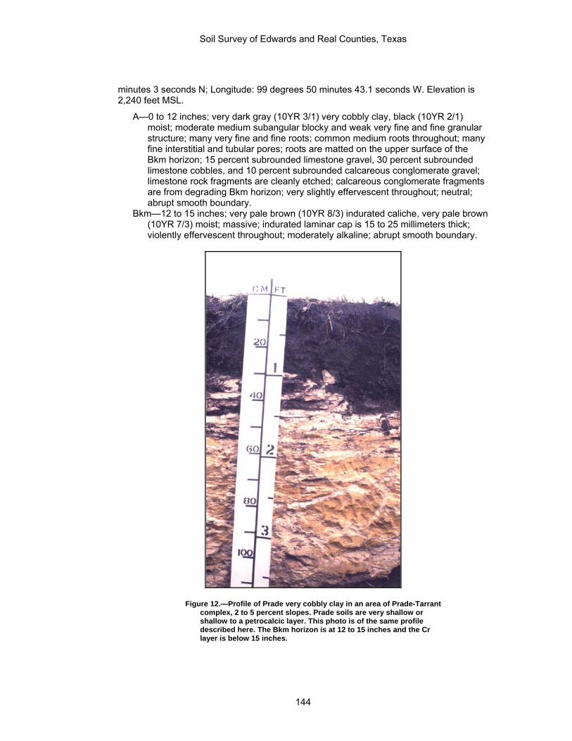
Soil Survey of Edwards and Real Counties, Texas
minutes 3 seconds N; Longitude: 99 degrees 50 minutes 43.1 seconds W. Elevation is 2,240 feet MSL.
A—0 to 12 inches; very dark gray (10YR 3/1) very cobbly clay, black (10YR 2/1) moist; moderate medium subangular blocky and weak very fine and fine granular structure; many very fine and fine roots; common medium roots throughout; many fine interstitial and tubular pores; roots are matted on the upper surface of the Bkm horizon; 15 percent subrounded limestone gravel, 30 percent subrounded limestone cobbles, and 10 percent subrounded calcareous conglomerate gravel; limestone rock fragments are cleanly etched; calcareous conglomerate fragments are from degrading Bkm horizon; very slightly effervescent throughout; neutral; abrupt smooth boundary.
Bkm—12 to 15 inches; very pale brown (10YR 8/3) indurated caliche, very pale brown (10YR 7/3) moist; massive; indurated laminar cap is 15 to 25 millimeters thick; violently effervescent throughout; moderately alkaline; abrupt smooth boundary.
Figure 12.—Profile of Prade very cobbly clay in an area of Prade-Tarrant complex, 2 to 5 percent slopes. Prade soils are very shallow or shallow to a petrocalcic layer. This photo is of the same profile described here. The Bkm horizon is at 12 to 15 inches and the Cr layer is below 15 inches.
144

Soil Survey of Edwards and Real Counties, Texas
Cr—15 to 62 inches; very pale brown (10YR 8/2) moderately cemented marl bedrock, very pale brown (10YR 8/2) moist; massive; no fractures or roots in marl bedrock; violently effervescent; moderately alkaline.
Solum thickness and depth to the petrocalcic horizon ranges from 6 to 20 inches and the depth to cemented marl bedrock ranges from 7 to 21 inches. The coarse fragment content of caliche and limestone fragments in the control section ranges from 35 to about 75 percent by volume. Calcium carbonate equivalent of the fine-earth fraction ranges from 0 to 11 percent.
The A horizon has 7.5YR or 10YR hue, value of 2 to 4, and chroma of 1 to 3. The fine-earth fraction is clay with a clay content of 40 to 60 percent. Coarse fragments range from 35 to 75 percent by volume. Texture is very cobbly clay or extremely cobbly clay. Reaction is neutral or slightly alkaline.
The Bkm horizon has hue of 10YR or 2.5Y, value of 7 or 8, and chroma of 2 to 4. The upper 3 millimeters to 30 millimeters of the Bkm is laminar and cementation ranges from strongly cemented to indurated.
The Cr layer is weakly to moderately cemented, weathered marl bedrock, chalk bedrock, or soft limestone bedrock that can be scraped or dug with a spade or backhoe. Some pedons are moderately cemented in the upper part and weakly cemented and massive below. Layers of limestone are mostly less than 20 centimeters thick. Hard limestone layers are present below 40 inches in some pedons.
Pratley Series
Map unit(s): PtB Depth class: Moderately deep Drainage class: Well drained Slowest permeability: 0.2 to 0.6 in/hr (moderately slow) Landform: Plains Parent material: Residuum weathered from limestone Elevation: 1,000 to 2,000 feet (305 to 610 meters) Slope: 1 to 3 percent Mean annual precipitation: 26 to 32 inches (660 to 813 millimeters) Mean annual air temperature: 64 to 70 degrees F (18.0 to 21.0 degrees C) Freeze-free period: 220 to 250 days Taxonomic class: Fine, smectitic, thermic Petrocalcic Calciustolls
Typical pedon of Pratley clay, 1 to 3 percent slopes; Real County, Texas; from the junction of Texas Highway 55 and Farm Road 336 north of Barksdale, 3.6 miles north on Farm Road 336, 2.0 miles east on ranch road, across Nueces River to fence line, about 1,075 feet south along fence line, and 50 feet east in pasture. USGS Quadrangle: Vance, Texas. Latitude: 29 degrees 45 minutes 34 seconds N; Longitude: 100 degrees 0 minutes 39 seconds W. Elevation is 1,581 feet MSL.
A1—0 to 12 inches; very dark grayish brown (10YR 3/2) clay, very dark brown (10YR 2/2) moist; moderate fine subangular blocky and granular structure; very hard, firm; many fine roots; few fine and medium pores; 1 percent subrounded 2 to 75 millimeters limestone fragments; slightly effervescent; moderately alkaline; clear smooth boundary.
A2—12 to 19 inches; brown (7.5YR 4/3) clay, dark brown (7.5YR 3/3) moist; moderate medium subangular blocky structure parting to moderate very fine angular blocky; very hard, very firm; many fine roots; few fine and medium pores; few distinct discontinuous stress surfaces on vertical and horizontal faces of peds; 7 percent subrounded 2 to 75 millimeters limestone fragments; strongly effervescent; moderately alkaline; clear wavy boundary.
145

Soil Survey of Edwards and Real Counties, Texas
Bk—19 to 24 inches; brown (7.5YR 5/3) extremely cobbly clay, brown (7.5YR 4/3) moist; moderate medium subangular blocky structure parting to moderate very fine angular blocky; 30 percent subangular 75 to 250 millimeters calcareous conglomerate fragments and 35 percent subangular 2 to 75 millimeters calcareous conglomerate fragments; fractured indurated laminar cap on caliche cobbles; violently effervescent; moderately alkaline; abrupt smooth boundary.
Bkm—24 to 30 inches; pink (7.5YR 8/4) strongly cemented caliche, pink (7.5YR 8/3), moist; 5 percent subrounded 2 to 75 millimeters limestone fragments indurated very pale brown (10YR 7/3) laminar cap 7 to 10 millimeters thick, pale brown (10YR 6/3), moist; violently effervescent; moderately alkaline; abrupt smooth boundary.
Cr/R—30 to 60 inches; very pale brown (10YR 8/3) chalk bedrock, very pale brown (10YR 8/3) moist; 70 percent weakly cemented chalk bedrock interbedded with 30 percent moderately and strongly cemented limestone bedrock; violently effervescent; moderately alkaline.
Solum thickness above the petrocalcic horizon ranges from 22 to 40 inches. The A horizon has hue of 7.5YR or 10YR, value of 4 to 8, and chroma of 2 to 4.
Texture is clay loam, silty clay, or clay. Clay content ranges from 35 to 45 percent. Coarse fragments range from 0 to 10 percent by volume. Reaction is slightly alkaline or moderately alkaline.
The Bw horizon where present has hue of 5YR or 7.5YR, value of 4 or 5, and chroma of 3 or 4. Clay content ranges from 45 to 60 percent. Coarse fragments range from 0 to 15 percent by volume. Reaction is slightly alkaline or moderately alkaline.
The Bk horizon has hue of 7.5YR or 10YR, value of 6 to 8, and chroma of 2 tor 4. Clay content ranges from 40 to 60 percent. Coarse fragments range from 60 to 90 percent by volume. Texture is extremely cobbly silty clay or extremely cobbly clay. Reaction is slightly alkaline or moderately alkaline.
The Bkm horizon ranges from 1 to 11 inches thick. The Cr/R layer ranges from extremely weakly to moderately cemented limestone
bedrock to interbedded chalk, marl, or strongly cemented to indurated limestone.
Real Series
Map unit(s): KrD, KrF, RaF Depth class: Very shallow and shallow Drainage class: Well drained Slowest permeability: 0.6 to 2.0 in/hr (moderate) Landform: Ridges Position on landform: Backslopes; Footslopes Parent material: Residuum weathered from limestone Elevation: 1,000 to 2,100 feet (305 to 640 meters) Slope: 1 to 40 percent Mean annual precipitation: 26 to 34 inches (660 to 864 millimeters) Mean annual air temperature: 64 to 70 degrees F (18.0 to 21.0 degrees C) Freeze-free period: 220 to 250 days Taxonomic class: Loamy-skeletal, carbonatic, thermic, shallow Typic Calciustolls
Typical pedon of Real very cobbly clay loam in an area of Real-Oplin complex, 1 to 20 percent slopes; Real County, Texas; in Camp Wood, from the intersection of Texas Highway 55 and Ranch Road 337, 0.5 mile east and northeast on Ranch Road 337, 0.6 mile east on ranch road, and 50 feet south in rangeland. USGS Quadrangle: Crown Mountain, Texas. Latitude: 29 degrees 40 minutes 19 seconds N; Longitude: 99 degrees 59 minutes 42 seconds W. Elevation is 1,572 feet MSL.
146

Soil Survey of Edwards and Real Counties, Texas
A1—0 to 8 inches; dark grayish brown (10YR 4/2) very cobbly clay loam, very dark grayish brown (10YR 3/2) moist; moderate medium subangular blocky and moderate fine granular structure; friable, slightly hard, moderately sticky, moderately plastic; common fine roots throughout; 20 percent 75 to 250 millimeters calcareous conglomerate fragments and 25 percent 2 to 75 millimeters calcareous conglomerate fragments; slightly effervescent; moderately alkaline; clear smooth boundary.
A2—8 to 13 inches; brown (10YR 4/3) extremely cobbly clay loam, dark brown (10YR 3/3) moist; moderate medium subangular blocky structure; friable, moderately hard, moderately sticky, moderately plastic; common fine roots throughout and common medium roots throughout; 35 percent 75 to 250 millimeters calcareous conglomerate fragments and 40 percent 2 to 75 millimeters calcareous conglomerate fragments; indurated laminar cap 5 to 8 millimeters thick on caliche cobbles; strongly effervescent; moderately alkaline; abrupt smooth boundary.
Cr1—13 to 15 inches; white (10YR 8/1) fractured limestone bedrock, very pale brown (10YR 8/2) moist; moderately cemented by carbonates; strongly effervescent; moderately alkaline; abrupt smooth boundary.
Cr2—15 to 48 inches; very pale brown (10YR 8/3) chalk and limestone bedrock, very pale brown (10YR 8/3) moist; chalk is weakly cemented by carbonates; 60 percent weakly cemented chalk that slakes in water and 40 percent moderately and strongly cemented limestone in vertical and horizontal seams; violently effervescent; moderately alkaline.
Solum thickness ranges from 8 to 20 inches, and corresponds to the depth to limestone bedrock. Coarse fragments in the sola average from 35 to 85 percent and consists of limestone pebbles and caliche fragments mostly from 0.2 inch to 3 inches in diameter. The calcium carbonate equivalent is estimated to range from 40 to 70 percent in the fraction less than 20 millimeters.
The A horizon has hue of 10YR, value of 3 to 5, and chroma of 1 to 3. The fine-earth fraction ranges from loam to clay loam with a silicate clay content of 22 to 35 percent. Carbonate clays range from a trace to about 6 percent. Secondary accumulations of calcium carbonate are soft bodies, cemented fragments, and coatings that are mostly on the lower surfaces of limestone fragments.
The Cr horizon is weakly to moderately cemented limestone chalk that is interbedded with strongly cemented limestone bedrock and limy earth of loamy and clayey textures that is assumed to be secondary accumulations of calcium carbonate. In some pedons the upper 0.5 to 3 inches is bedrock plugged with cemented secondary carbonates but the continuity, crack spacing, and/or thickness does not meet the requirements of a petrocalcic horizon.
Rio Diablo Series
Map unit(s): RdB Depth class: Very deep Drainage class: Well drained Slowest permeability: 0.2 to 0.6 in/hr (moderately slow) Landform: Step flood plains; Step flood plains on draws Parent material: Alluvium derived from limestone Elevation: 1,500 to 2,300 feet (457 to 701 meters) Slope: 0 to 2 percent Mean annual precipitation: 15 to 22 inches (381 to 559 millimeters) Mean annual air temperature: 66 to 70 degrees F (19.0 to 21.0 degrees C) Freeze-free period: 230 to 260 days Taxonomic class: Fine, mixed, superactive, thermic Aridic Haplustolls
147

Soil Survey of Edwards and Real Counties, Texas
Typical pedon of Rio Diablo silty clay, 0 to 2 percent slopes, rarely flooded (fig. 13); Edwards County, Texas; from the junction of U.S. Highway 277 and Texas Highway 55 in northwestern Edwards County, 4.3 miles south on U.S. Highway 277, and 50 feet east of fence in rangeland. USGS Quadrangle: Turney Draw SE, Texas. Latitude: 30 degrees 13 minutes 45 seconds N; Longitude: 100 degrees 39 minutes 49 seconds W. Elevation is 2,120 feet MSL.
A1—0 to 10 inches; brown (7.5YR 4/2) silty clay, dark brown (7.5YR 3/2) moist; weak medium prismatic structure parting to weak medium subangular blocky parting to moderate very fine and fine granular; slightly hard, very friable, moderately sticky, moderately plastic; common very fine and fine roots throughout and common medium roots throughout; common very fine and fine moderate continuity interstitial and tubular and common medium and coarse high continuity tubular pores; 1 percent subrounded 2 to 75 millimeter limestone fragments all are pebbles less than 20 millimeters in diameter, etched smooth on upper surface, and rough on lower surfaces; violently effervescent; moderately alkaline; clear wavy boundary.
A2—10 to 15 inches; brown (7.5YR 4/2) silty clay, dark grayish brown (7.5YR 3/2) moist; weak medium prismatic structure parting to moderate medium subangular blocky parting to moderate very fine and fine granular; slightly hard, very friable, moderately sticky, moderately plastic; common very fine and fine roots throughout, common medium roots throughout common very fine and fine moderate continuity interstitial and tubular and common medium and coarse high continuity tubular pores; 1 percent subrounded 2 to 75 millimeter limestone fragments; all limestone pebbles are less than 20 millimeters in diameter, etched smooth on upper surface, and rough on lower surface; violently effervescent; moderately alkaline; clear wavy boundary.
Bw1—15 to 22 inches; brown (7.5YR 5/2) silty clay, brown (7.5YR 4/2) moist; weak medium prismatic structure parting to moderate fine and medium subangular blocky; slightly hard, friable, moderately sticky, moderately plastic common very fine and fine roots throughout; common very fine and fine moderate continuity interstitial and tubular and common medium and coarse high continuity tubular pores; 10 percent continuous distinct pressure faces on horizontal faces of peds; 1 percent subrounded 2 to 75 millimeter limestone fragments; 2 percent brown (7.5YR 4/2) streaks to 4 millimeters wide oriented along prism faces that appear to be filled cracks; an ant chamber is 15 millimeters in diameter with tubular pores connecting to it; all limestone pebbles are less than 20 millimeters in diameter, etched smooth on upper surface, and rough on lower surface; violently effervescent; moderately alkaline; gradual wavy boundary.
Bw2—22 to 33 inches; brown (7.5YR 5/3) silty clay; brown (7.5YR 4/3) moist; weak medium prismatic structure parting to moderate fine and medium subangular blocky; slightly hard, friable, moderately sticky, moderately plastic common very fine and fine roots throughout and common very coarse roots throughout; common very fine and fine moderate continuity interstitial and tubular pores; 25 percent continuous distinct pressure faces on horizontal faces of peds; 1 percent subrounded 2 to 75 millimeter limestone fragments; 1 percent brown (7.5YR 4/2) streaks to 4 millimeters wide oriented along prism faces; all limestone pebbles are less than 20 millimeters in diameter, etched smooth on upper surface, and rough on lower surfaces; violently effervescent; moderately alkaline; clear wavy boundary.
Bk—33 to 43 inches; brown (7.5YR5/3) silty clay; brown (7.5YR 4/3) moist; weak coarse prismatic structure parting to moderate fine and medium subangular blocky; slightly hard, friable moderately sticky, moderately plastic; common very fine and fine roots throughout; common fine moderate continuity dendritic tubular pores; 1 percent fine dendritic carbonate threads throughout; 1 percent subrounded 20 to 75 millimeter limestone fragments and 8 percent subrounded 2 to 75 millimeter limestone fragments; 1 percent fine and medium soft masses of lime without limestone at core;
148

Soil Survey of Edwards and Real Counties, Texas
few snail shell fragments; 1 percent earthworm krotovinas and channels filled with wormcasts; 7 percent limestone pebbles 2 to 20 millimeters in diameter; 1 percent pebbles 20 to 75 millimeters in diameter; limestone pebbles are etched smooth on upper surface, and rough on lower surface; violently effervescent; moderately alkaline; clear wavy boundary.
2Bk—43 to 63 inches; 94 percent light brown (7.5YR 6/4), and 6 percent pink (7.5YR 8/4) gravelly clay, brown (7.5YR 5/4), and pink (7.5YR 7/4) moist; weak fine subangular blocky structure; slightly hard, very friable, moderately sticky, moderately plastic; few very fine and fine roots throughout common fine moderate continuity dendritic tubular pores; 1 percent fine dendritic carbonate threads throughout and 4 percent coarse spherical lime masses throughout; 10 percent subrounded 75 to 250 millimeter limestone fragments and 17 percent subrounded 2 to 75 millimeter limestone fragments; masses of lime may have their origin as weathered limestone pebbles, half of which contain limestone in center; 1 percent masses of lime as coats on limestone pebbles; 7 percent limestone pebbles 2 to 20 millimeters in diameter; 10 percent limestone pebbles 20 to 75 mm in diameter; limestone pebbles are etched smooth on upper surface, and rough on lower surfaces; violently effervescent; moderately alkaline; abrupt wavy boundary.
Figure 13.—Profile of Rio Diablo silty clay, 0 to 2 percent slopes, rarely flooded.
149

Soil Survey of Edwards and Real Counties, Texas
2BCk—63 to 80 inches; 88 percent pink (7.5YR 7/4), and 12 percent pink (7.5YR 8/4) cobbly silt loam, light brown (7.5YR 6/4), and pink (7.5YR 7/4) moist; weak medium subangular blocky structure; hard, friable, moderately sticky, moderately plastic; many very fine and fine dendritic tubular pores 2 percent fine dendritic carbonate threads throughout and 8 percent coarse irregular lime masses throughout; 10 percent subrounded 2 to 75 millimeter limestone fragments and 15 percent subrounded 75 to 250 millimeter limestone fragments; masses of lime may have their origins as weathered limestone pebbles; 2 percent masses of lime as coats on limestone pebbles up to 3 millimeters thick, thicker on lower sides of pebbles; 30 percent of horizon within the pedon is weakly cemented; 3 percent limestone pebbles 2 to 20 millimeters in diameter; 7 percent limestone pebbles 20 to 75 millimeters in diameter; limestone pebbles etched, smooth on upper surface, and rough on lower surface; violently effervescent; moderately alkaline
Solum thickness ranges from 60 to more than 80 inches. Depth to limestone or gravel ranges from 6 to 20 feet. Limestone fragments of pebble size range from 0 to 15 percent by volume. COLE ranges from 0.03 to 0.05. Clay content of the 10- to 40-inch control section ranges from 40 to 55 percent and silicate clay ranges from 35 to 45 percent. Calcium carbonate equivalent of the 10- to 40-inch control section ranges from 20 to 40 percent with 0 to 5 percent in visible secondary forms.
The A horizons have hue of 10YR, or 7.5YR, value of 2 to 4, and chroma of 2. Texture is silty clay loam, silty clay, or clay.
The Bw and Bk horizon has hue of 7.5YR or 10YR, value of 3 to 5, and chroma of 2 to 4. Texture is silty clay loam, silty clay, or clay. Visible segregations of lime comprise less than 5 percent of any B horizon having its upper boundary within 40 inches of the surface. Bk horizons with upper boundaries below 40 inches contain 5 to 20 percent visible segregations of lime. Some pedons have gravelly or cobbly 2Bk horizons below 40 inches.
The 2BCk when present has colors and textures like the Bw and Bk that includes silt loam, with gravelly or cobbly strata.
Rio Frio Series
Map unit(s): RfB Depth class: Very deep Drainage class: Well drained Slowest permeability: 0.6 to 2.0 in/hr (moderate) Landform: Step flood plains; Step flood plains on draws Parent material: Alluvium derived from limestone Elevation: 1,200 to 2,000 feet (366 to 610 meters) Slope: 0 to 2 percent Mean annual precipitation: 26 to 30 inches (660 to 762 millimeters) Mean annual air temperature: 63 to 70 degrees F (17.0 to 21.0 degrees C) Freeze-free period: 230 to 270 days Taxonomic class: Fine-loamy, carbonatic, thermic Typic Calciustepts
Typical pedon of Rio Frio clay loam, in an area of Rio Frio-Vanderpool complex, 0 to 2 percent slopes, rarely flooded; Real County, Texas; from the intersection of U.S. Highway 83 and Ranch Road 1120, 3.8 miles east and north on Ranch Road 1120, and 1,420 feet east in pasture. USGS Quadrangle: Rio Frio, Texas. Latitude: 29 degrees 40 minutes 12.5 seconds N; Longitude: 99 degrees 44 minutes 20 seconds W. Elevation is 1,515 feet MSL.
Ap—0 to 6 inches; grayish brown (10YR 5/2) clay loam, dark grayish brown (10YR 4/2) moist; weak fine subangular blocky structure; hard, firm; slightly sticky and slightly plastic; common very fine and fine roots; common very fine and fine
150

Soil Survey of Edwards and Real Counties, Texas
tubular pores; few snail shell fragments; few masses of calcium carbonate; strongly effervescent; moderately alkaline; clear smooth boundary.
Ak—6 to 13 inches; grayish brown (10YR 5/2) clay loam, dark grayish brown (10YR 4/2) moist; weak fine subangular blocky structure; hard, firm, slightly sticky and slightly plastic; common very fine and fine roots; common very fine and fine tubular pores; few snail shell fragments; few fine dendritic white (10YR 8/1) threads of calcium carbonate; strongly effervescent; moderately alkaline; gradual smooth boundary.
Bk1—13 to 25 inches; pale brown (10YR 6/3) clay loam, brown (10YR 5/3) moist; weak fine subangular blocky structure; hard, firm, slightly sticky and slightly plastic; common very fine and fine roots; common very fine and fine tubular pores; few snail shell fragments; common fine dendritic white (10YR 8/1) threads of calcium carbonate; strongly effervescent; moderately alkaline; gradual smooth boundary.
Bk2—25 to 53 inches; very pale brown (10YR 7/3) clay loam, pale brown (10YR 6/3) moist; weak fine subangular blocky structure; hard, firm; slightly sticky and slightly plastic; few very fine roots; few very fine and fine tubular pores; few snail shell fragments; few fine rounded white (10YR 8/1) masses of calcium carbonate; few fine dendritic white (10YR 8/1) threads of calcium carbonate; strongly effervescent; moderately alkaline; clear smooth boundary.
Bk3—53 to 80 inches; light brown (7.5YR 6/4) clay loam, brown (7.5YR 5/4) moist; weak fine subangular blocky structure; hard, firm; slightly sticky and slightly plastic; few very fine roots; few very fine continuous tubular pores; few snail shell fragments; 24 percent calcium carbonate equivalent; few fine rounded white (10YR 8/1) masses of calcium carbonate; few fine rounded white (10YR 8/1) threads of calcium carbonate; strongly effervescent; moderately alkaline.
Solum thickness is more than 80 inches. Calcium carbonate equivalent in the 10- to 40-inch particle-size control section ranges from 40 to 70 percent. Snail shell fragments are in all horizons. Films and threads of calcium carbonate are evident in all horizons below the Ap horizon and increase with depth. Total clay content ranges from 20 to 40 percent. Carbonate clay ranges from 2 to 15 percent. Siliceous and limestone pebbles ranges from 0 to 15 percent.
The A horizon has hue of 10YR, value of 4 to 6, and chroma of 2 or 3. Texture is clay loam or loam. Films and threads of calcium carbonate range from none to few in the lower part.
The Bk horizon has hue of 7.5YR or 10YR, value of 4 to 7, and chroma of 3 or 4. Texture is loam or clay loam. In some pedons, the lower part of the horizon contains up to 50 percent limestone pebbles and calcium carbonate concretions.
Spires Series
Map unit(s): StC Depth class: Moderately deep Drainage class: Well drained Slowest permeability: 0.06 to 0.2 in/hr (slow) Landform: Plains Parent material: Residuum weathered from limestone Elevation: 1,600 to 2,400 feet (488 to 732 meters) Slope: 1 to 5 percent Mean annual precipitation: 24 to 30 inches (610 to 762 millimeters) Mean annual air temperature: 64 to 68 degrees F (18.0 to 20.0 degrees C) Freeze-free period: 210 to 240 days Taxonomic class: Fine, mixed, active, thermic Rhodic Paleustalfs
151

Soil Survey of Edwards and Real Counties, Texas
Typical pedon of Spires loam in an area of Spires association, gently undulating; Bandera County, Texas; 10.8 miles north of Vanderpool on Farm Road 187, 0.25 mile west on private road, 0.6 mile north on private road, and 60 feet east in rangeland. USGS Quadrangle: Sabinal Canyon, Texas. Latitude: 29 degrees 51 minutes 24.01 seconds N; Longitude: 99 degrees 33 minutes 29.57 seconds W. Elevation is 2,250 feet MSL. This pedon represents Spires in Edwards and Real Counties.
A—0 to 6 inches; reddish brown (5YR 4/4) loam, dark reddish brown (5YR 3/4) moist; weak fine granular structure; very hard, friable; many fine roots; 5 percent chert fragments, 0.5 inch to 4 inch diameter; neutral, clear smooth boundary.
Bt—6 to 28 inches; dark red (10R 3/6) clay, dark red (10R 3/6) moist; moderate medium blocky structure; very hard, very firm; few fine roots; clay films on vertical faces of peds and few distinct clay films on horizontal faces of peds; 10 percent chert fragments and few chert cobbles; few wormcasts; slightly alkaline; abrupt wavy boundary.
R—28 to 38 inches; indurated, fractured crystalline limestone bedrock
Solum thickness and depth to limestone ranges from 20 to 40 inches. Coarse fragments, consisting of chert from 0.5 inch to 6 inches across the long axis, range from 2 to 25 percent. Some pedons have fragments of chert and limestone ranging from 6 to 24 inches in diameter. Reaction ranges from slightly acid through slightly alkaline.
The A horizon has hue of 5YR or 7.5YR, value of 1 to 3, and chroma of 3 to 5. Colors that are within the ranges of a mollic epipedon lack required thickness. Texture is loam or clay loam or their gravelly or cobbly counterparts. The A horizon is massive or has weak structure and is hard or very hard when dry. The increase in clay content between the A and Bt horizon is 20 to 36 percent within less than 3 inches.
The Bt horizon has hue of 10YR or 2.5YR, value of 4 or 6, and chroma of 2 to 4. Moist values are less than 4. Clay content ranges from 42 to 57 percent.
The R layer is strongly cemented to indurated limestone bedrock.
Tarpley Series
Map unit(s): StC Depth class: Shallow Drainage class: Well drained Slowest permeability: 0.06 to 0.2 in/hr (slow) Landform: Plains Parent material: Residuum weathered from limestone Elevation: 1,000 to 2,000 feet (305 to 610 meters) Slope: 1 to 5 percent Mean annual precipitation: 28 to 35 inches (711 to 889 millimeters) Mean annual air temperature: 64 to 70 degrees F (18.0 to 21.0 degrees C) Freeze-free period: 220 to 250 days Taxonomic class: Clayey, smectitic, thermic Lithic Argiustolls
Typical pedon of Tarpley clay loam in an area of Tarpley-Roughcreek association, gently undulating; Kerr County, Texas; from the intersection of Texas Highway 16 and Ranch Road 1341 in Kerrville, 5.0 miles east on Ranch Road 1341, 1.5 miles south on private ranch road, and 150 feet east in rangeland. USGS Quadrangle: Legion, Texas. Latitude: 30 degrees 02 minutes 31.27 seconds N; Longitude: 99 degrees 04 minutes 25.47 seconds W. Elevation is 1,910 feet MSL. This pedon represents Tarpley soils in the Edwards and Real County soil survey.
A—0 to 7 inches; dark reddish brown (5YR 3/2) clay loam, dark reddish brown (5YR 2/2) moist; moderate medium angular blocky structure parting to moderate fine granular; hard, firm; many fine and few medium roots; common fine irregular
152
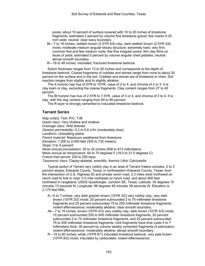
Soil Survey of Edwards and Real Counties, Texas
pores; about 10 percent of surface covered with 10 to 20 inches of limestone fragments; estimated 2 percent by volume fine limestone gravel; few cracks 0.25 inch wide; neutral; clear wavy boundary.
Bt—7 to 18 inches; reddish brown (2.5YR 4/4) clay, dark reddish brown (2.5YR 3/4) moist; moderate medium angular blocky structure; extremely hard, very firm; common fine and few medium roots; few fine irregular pores; thin clay films on faces of peds; estimated 5 percent by volume angular chert pebbles; neutral; abrupt smooth boundary.
R—18 to 48 inches; indurated, fractured limestone bedrock.
Solum thickness ranges from 13 to 20 inches and corresponds to the depth of limestone bedrock. Coarse fragments of cobbles and stones range from none to about 30 percent on the surface and in the soil. Cobbles and stones are of limestone or chert. Soil reaction ranges from slightly acid to slightly alkaline.
The A horizon has hue of 5YR to 10YR, value of 2 to 4, and chroma of 2 or 3. It is clay loam or clay, excluding the coarse fragments. Clay content ranges from 27 to 40 percent.
The Bt horizon has hue of 2.5YR to 7.5YR, value of 3 or 4, and chroma of 2 to 4. It is clay, with the clay content ranging from 60 to 80 percent.
The R layer is strongly cemented to indurated limestone bedrock.
Tarrant Series
Map unit(s): TeA, PrC, TvB Depth class: Very shallow and shallow Drainage class: Well drained Slowest permeability: 0.2 to 0.6 in/hr (moderately slow) Landform: Undulating plains Parent material: Residuum weathered from limestone Elevation: 1,000 to 2,400 feet (305 to 732 meters) Slope: 0 to 5 percent Mean annual precipitation: 20 to 32 inches (508 to 813 millimeters) Mean annual air temperature: 64 to 70 degrees F (18.0 to 21.0 degrees C) Freeze-free period: 230 to 250 days Taxonomic class: Clayey-skeletal, smectitic, thermic Lithic Calciustolls
Typical pedon of Tarrant very cobbly clay in an area of Tarrant-Valera complex, 0 to 3 percent slopes; Edwards County, Texas; in northwestern Edwards County, Texas; from the intersection of U.S. Highway 83 and private ranch road, 2.3 miles west northwest on ranch road to fork in road, 0.5 mile northeast on ranch road, and about 900 feet northwest in rangeland. USGS Quadrangle: Junction SE, Texas. Latitude: 30 degrees 15 minutes 13 seconds N; Longitude: 99 degrees 46 minutes 39 seconds W. Elevation is 2,175 feet MSL.
A—0 to 7 inches; very dark grayish brown (10YR 3/2) very cobbly clay, very dark brown (10YR 2/2) moist; 20 percent subrounded 2 to 75 millimeter limestone fragments and 25 percent subrounded 75 to 250 millimeter limestone fragments; violent effervescence; moderately alkaline; clear smooth boundary.
Ak—7 to 15 inches; brown (10YR 4/3) very cobbly clay, dark brown (10YR 3/3) moist; 10 percent subrounded 250 to 600 millimeter limestone fragments, 20 percent subrounded 2 to 75 millimeter limestone fragments, and 25 percent subrounded 75 to 250 millimeter limestone fragments; rock fragments have lime coats 5 to 7 millimeters thick; 30 percent by volume weakly cemented fragments of petrocalcic; violent effervescence; moderately alkaline; abrupt smooth boundary.
R—15 to 80 inches; white (10YR 8/1) indurated limestone bedrock, very pale brown (10YR 8/2) moist; indurated by carbonates; violent effervescence.
153

Soil Survey of Edwards and Real Counties, Texas
Solum thickness ranges from 6 to 20 inches and corresponds to the depth to indurated limestone bedrock. The solum contains 35 to 85 percent coarse fragments, the amount ranging from 10 to 60 percent in the A horizon, and from 50 to 90 percent in the Ak horizon. Coarse fragments are dominantly limestone but some pedons include quartziferous fragments. The fragments greater than 3 inches in diameter comprise 25 to 70 percent of the soil and consist of cobbles, flags, and stones. Fragments less than 3 inches in diameter are mostly larger than 20 millimeters diameter. Secondary coating of calcium carbonate on the fragments is lacking in the upper 4 inches of some pedons, but is 1 centimeter or more thick on some fragments immediately above the R layer. Carbonates are in the form of coatings and pendants.
The A horizon has hue of 7.5YR or 10YR, value of 2 to 5, and chroma of 1 to 3. Chroma of 1 is not associated with wetness. It is silty clay or clay, or their cobbly, very cobbly, stony, or very stony counterparts. Many pedons have an extremely cobbly or flaggy layer immediately above the bedrock. Clay content of the fine-earth fraction is 40 to 60 percent.
The R layer is strongly cemented to indurated limestone bedrock.
Valera Series
Map unit(s): TvB, VaA Depth class: Moderately deep Drainage class: Well drained Slowest permeability: 0.2 to 0.6 in/hr (moderately slow) Landform: Plains Parent material: Slope alluvium derived from limestone Elevation: 1,500 to 2,500 feet (457 to 762 meters) Slope: 0 to 2 percent Mean annual precipitation: 16 to 26 inches (406 to 660 millimeters) Mean annual air temperature: 64 to 70 degrees F (18.0 to 21.0 degrees C) Freeze-free period: 220 to 240 days Taxonomic class: Fine, smectitic, thermic Petrocalcic Calciustolls
Typical pedon of Valera clay in an area of Tarrant-Valera complex, 0 to 3 percent slopes; Edwards County, Texas; from the junction of U.S. Highway 377 and Farm Road 674 west of Rocksprings, 3.3 miles west on U.S. Highway 377 to gate, 0.3 mile north northeast and north on private ranch road, and 200 feet east in rangeland. USGS Quadrangle: Ray Lake SE, Texas. Latitude: 30 degrees 0.0 minutes 30.1 seconds N; Latitude: 100 degrees 18 minutes 39.5 seconds W. Elevation is 2,201 feet MSL.
A—0 to 10 inches; very dark gray (10YR 3/1) clay, black (10YR 2/1) moist; moderate fine subangular blocky structure; slightly hard, friable, moderately sticky, moderately plastic; many very fine and fine roots throughout and common medium and coarse roots throughout; common very fine and fine high continuity interstitial and many very fine and fine high continuity tubular pores; 1 percent subrounded 2 to 75 millimeter limestone fragments; violently effervescent; moderately alkaline; clear smooth boundary.
Bw—10 to 26 inches; brown (10YR 4/3) silty clay, dark brown (10YR 3/3) moist; moderate fine and medium subangular blocky structure; hard, firm, very sticky, very plastic; many very fine and fine roots throughout and common medium and coarse roots throughout; common very fine and fine high continuity interstitial and many very fine and fine high continuity tubular pores; 1 percent subrounded 2 to 75 millimeters limestone fragments; violently effervescent; moderately alkaline; clear smooth boundary.
Bk—26 to 30 inches; brown (7.5YR 5/3) silty clay, brown (7.5YR 4/3) moist; weak fine and medium subangular blocky structure; hard, firm, moderately sticky,
154
Soil Survey of Edwards and Real Counties, Texas
moderately plastic; many very fine and fine roots throughout and few medium and coarse roots throughout; common very fine and fine high continuity interstitial and many very fine and fine high continuity tubular pores; 2 percent fine spherical carbonate nodules throughout and 2 percent fine and medium dendritic masses of calcium carbonate throughout; 3 percent subrounded 2 to 75 millimeters limestone fragments; violently effervescent; moderately alkaline; abrupt smooth boundary.
Bkm—30 to 32 inches; pink (7.5YR 8/4) strongly cemented caliche, pink (7.5YR 8/4) moist; massive; cemented by carbonates; petrocalcic horizon with a 4 millimeter thick laminar cap; violently effervescent; moderately alkaline; abrupt smooth boundary.
R—32 to 80 inches; very pale brown (10YR 8/3) strongly cemented limestone bedrock, very pale brown (10YR 8/3) moist; massive; cemented by carbonates.
Solum thickness ranges from 20 to 40 inches and corresponds to the depth to the petrocalcic horizon. Coarse fragments of limestone comprise less than 15 percent of the control section. When dry, the soil has cracks from 1 to 2 centimeters wide and 25 to 50 centimeters deep, but the coefficient of linear extensibility is less than 0.07 in all horizons. Texture of all horizons ranges from silty clay to clay. Clay content ranges from 40 to 55 percent. Reaction is slightly alkaline or moderately alkaline.
The A horizon has hue of 7.5YR or 10YR, value of 3 to 5, and chroma 1 to 3. The Bw or Bk horizon is lacking in many pedons, but where present, has hue of
7.5YR or 10YR, value of 4 to 7, and chroma 2 to 4. The Bkm horizon ranges from weakly cemented to indurated calcium carbonate that
is pink to white or very pale brown. The R layer ranges from indurated limestone containing interbedded marls, to soft
limestones having moderately cemented upper layers, to a mixture of limestone fragments, marls, and cemented caliche.
Vanderpool Series
Map unit(s): RfB Depth class: Very deep Drainage class: Well drained Slowest permeability: 0.6 to 2.0 in/hr (moderate) Landform: Step flood plains; Step flood plains on draws Position on landform: Step flood plains; Step flood plains on draws Parent material: Alluvium derived from limestone Elevation: 1,200 to 2,000 feet (366 to 610 meters) Slope: 0 to 2 percent Mean annual precipitation: 26 to 30 inches (660 to 762 millimeters) Mean annual air temperature: 63 to 70 degrees F (17.0 to 21.0 degrees C) Freeze-free period: 230 to 270 days Taxonomic class: Fine-loamy, carbonatic, thermic Typic Haplustolls
Typical pedon of Vanderpool clay loam, in an area of Rio Frio-Vanderpool complex, 0 to 2 percent slopes, rarely flooded; Real County, Texas; from the intersection of U.S. Highway 83 and Ranch Road 1120, 3.7 miles east and north on Ranch Road 1120, and 1,750 feet east in pasture. USGS Quadrangle: Rio Frio, Texas. Latitude 29 degrees 40 minutes 8.3 seconds N; Longitude 99 degrees 44 minutes 13.9 seconds W. Elevation is 1,570 feet MSL.
Ap—0 to 7 inches; dark grayish brown (10YR 4/2) clay loam, very dark grayish brown (10YR 3/2) moist; weak fine subangular blocky structure; hard, firm, slightly sticky and slightly plastic; common very fine and fine roots throughout; common very fine and fine tubular pores; few snail shell fragments; 38 percent calcium carbonate
155

Soil Survey of Edwards and Real Counties, Texas
156
equivalent; strongly effervescent throughout; moderately alkaline; clear smooth boundary.
Ak—7 to 16 inches; dark grayish brown (10YR 4/2) clay loam, very dark grayish brown (10YR 3/2) moist; weak fine subangular blocky structure; hard, firm, slightly sticky and slightly plastic; common very fine and fine roots throughout; common very fine and fine tubular pores; few snail shell fragments; 45 percent calcium carbonate equivalent; few fine dendritic white (10YR 8/1) soft carbonate threads throughout; strongly effervescent throughout; moderately alkaline; gradual smooth boundary.
Bk1—16 to 36 inches; pale brown (10YR 6/3) clay loam, brown (10YR 5/3) moist; weak fine subangular blocky structure; hard, firm, slightly sticky and slightly plastic; common very fine and fine roots throughout; common very fine and fine tubular pores; few snail shell fragments; 45 percent calcium carbonate equivalent; common fine dendritic white (10YR 8/1) soft carbonate threads throughout; strongly effervescent throughout; moderately alkaline; gradual smooth boundary.
Bk2—36 to 80 inches; reddish yellow (7.5YR 6/6) clay loam, strong brown (7.5YR 5/6) moist; weak fine subangular blocky structure; hard, firm, slightly sticky and slightly plastic; few very fine roots throughout; few very fine tubular pores; few snail shell fragments; 54 percent calcium carbonate equivalent; common fine dendritic white (10YR 8/1) soft carbonate threads throughout; strongly effervescent throughout; moderately alkaline.
Solum thickness is more than 80 inches. Calcium carbonate equivalent in the 10- to 40-inch control section ranges from 40 to 70 percent. Snail shell fragments are in all horizons. Films and threads of calcium carbonate are evident in all horizons below the Ap horizon and increase with depth. The calcium carbonate filaments are commonly seen when dry, but are not identifiable when moist or the soil contains less than 5 percent identifiable secondary calcium carbonates. The total clay content ranges from 20 to 40 percent with silicate clay ranging from 18 to 35 percent and carbonate clay from 2 to 15 percent. Siliceous and limestone pebble content ranges from 0 to 15 percent.
The A horizons have color with 10YR hue, value of 3 to 5, and chroma of 2 or 3. Texture is clay loam.
The Bk horizons have color with 7.5YR or 10YR hue, value of 5 or 8, and chroma of 1 to 6. Texture is loam or clay loam. In some pedons below 40 inches contains up to 50 percent by volume of limestone pebbles and calcium carbonate concretions.

Formation of the Soils
In this section, the factors of soil formation to include parent material, climate, plant and animal life, relief, and time are discussed and are related to the formation of the soils in Edwards and Real Counties. Also, the processes of horizon differentiation and the surface geology of the counties are described.
Factors of Soil Formation Soil is formed by the action of soil-forming processes on material deposited or
accumulated by geological forces. The characteristics of a soil depend on the physical and mineralogical composition of the parent material, the climate under which the soil material has accumulated and has existed since accumulation, the plant and animal life on and in the soil, the relief, and the length of time the forces of soil development have acted on the soil material.
Climate and living organisms are active factors of soil formation. They act on the parent material that has accumulated through the weathering of rocks and slowly change it into a natural body that has genetically related horizons. The effects of climate and living organisms are conditioned by relief. The parent material affects the kind of soil profile that forms and, in extreme cases, determines it almost entirely. Finally, time is needed for changing the parent material into soil. Generally, a long time is needed for the development of distinct horizons.
The factors of soil formation are so closely interrelated in their effects on the soil that few generalizations can be made regarding the effect of any one factor unless conditions are specified for the other factors.
Parent Material
Parent material is the unconsolidated organic and inorganic material in which a soil forms. The parent material determines the physical and chemical limits of the soil. For example, the Oplin and Real soils have calcareous loamy surface layers. The parent material for Oplin and Real weathered from limestone. The Roscoe soils have clay surface layers. The parent material for Roscoe soils is clayey playa deposits
The Dev, Nuvalde, and Rio Frio soils formed in calcareous alluvium along the Frio and Nueces Rivers. The parent material of these soils contained calcium carbonate and all of these soils are calcareous throughout.
Climate
Edwards and Real Counties have a subhumid climate with mild, dry winters and hot summers. Low rainfall and high evaporation rate, temperature, and wind are some of the climatic factors which influence soil formation.
The variable rainfall pattern causes the soil to be alternately wet and dry. When a clayey soil such as Irion becomes dry, it cracks. Animals, rainfall, and wind deposit surface soil in the cracks. During rains the cracks fill with water, the soil swells as it gets wet, and the cracks close. This alternate shrinking and swelling upon drying and wetting causes a rise and fall in the soil surface, and churning or mixing of the soil that has been termed "self swallowing" (Newman, 1982). The cracks in these soils, initially, allow the soil to take in water rapidly and wet deeply. Deep soil development and gilgai microrelief are the results of these processes.
157

Soil Survey of Edwards and Real Counties, Texas
Water moving through the soil can carry clay particles downward in suspension from the surface layer. The clay particles are deposited in the subsoil as the water flow ceases. As clay accumulates, permeability decreases, slowing future water movement, and deposition of clay accelerates. Spires soils have clay accumulations in their subsoils.
Rainfall also leaches minerals from the upper layers and deposits them in the lower layers. As a result, Nuvalde, Real, and many other soils have a layer in which calcium carbonate has accumulated.
Also, the accumulation of organic matter is affected by temperature and moisture. Low rainfall and high temperatures limit the vegetative growth and accumulation of organic matter in the soils. However, in those areas where more soil moisture is present, such as flood plains and depressional areas, the vegetative production and organic matter contents are higher than the surrounding upland soils. Near surface soil temperatures are lower where there is more vegetation, and the rate of decomposition of organic matter is generally slower.
Plant and Animal Life
Plants, animals, earthworms, insects, and micro-organisms are important factors in the formation of soils. The amount of organic matter and nitrogen in the soil, gains or losses in plant nutrients, and changes in soil structure and porosity are among the effects of living organisms.
Vegetation, predominantly grasses and brush, has played a major role in soil formation in Edwards and Real Counties. Decayed roots contribute organic matter to the soils and leave channels and pores that provide passageways for the intake of air and water. Deep rooting brush plants bring nutrients from the subsoil to the surface.
Earthworms, insects, and burrowing animals mix soil materials and create channels for the downward movement of air, water, and plant roots into the soil. Actinomycetes, bacteria, and fungi break down primary forms of organic matter, create humus, and release plant nutrients which improve soil tilth and fertility.
Humans have greatly affected the soils in Edwards and Real Counties. In the past, some rangeland has been overstocked with livestock and native wildlife. This resulted in overgrazing which caused the better grasses, brush, and forbs to decrease, and be replaced with less desirable grasses, brush, and forbs. Overgrazing by livestock and other animals increases the amount of bare ground and soil compaction, thereby increasing runoff and soil erosion.
Farming has resulted in excessive water and wind erosion in some areas. Crop residue management, terraces, grassed waterways, reduced tillage, and vegetated windstrips help control erosion on cropland. Soil compaction because of farm equipment has slowed the movement of air, moisture, and roots in the soil on much of the cropland in the survey area.
Relief
Relief or topography affects soil formation through its influence on drainage, erosion, and plant cover. The degree of development of a soil profile depends on the amount of water that enters the soil, provided other factors of soil formation are equal.
Soils such as Nuvalde that are nearly level absorb more rainfall, have greater profile development, less water erosion, and less runoff, generally, than soils such as Kerrville that are steep. Soils on steeper slopes may erode away nearly as fast as they form. On nearly level slopes, which are more stable, the rate of soil formation generally exceeds soil loss through erosion, and deeper soil profiles develop.
158

Soil Survey of Edwards and Real Counties, Texas
Time
The characteristics of a soil are determined mainly by the length of time that the soil forming factors have been active. Hundreds to thousands of years may be required for the formation of well-defined, genetic horizons. Genetically, the soils in Edwards and Real Counties range from very young to old. Differences in the ages of the soils can be noted in their profiles.
The Orif soil is a young soil which developed on recent flood plains. This soil consists of altered alluvial sediments.
Old soils are generally nearly level to gently undulating, and are on stable, upland positions on the landscape that are actually ancient stream terraces. The Mailtrail soil is an old soil in which calcium carbonate was leached from the upper part of the profile, and accumulated as a layer of cemented caliche.
Processes of Horizon Differentiation Soils are derived from the decomposition of the mineral particles they contain and
from the plant and animal remains added to them. Silicate clays, mineral particles, humus, living organisms, and water have a major influence in determining the character of the soil. Soil layers, or horizons, are formed by additions, removals, transfers, and transformations within the soil profile (Wilding and others, 1983). These processes include additions or losses of organic, mineral, and gaseous materials to the soil, transfers of material from one point to another within the soil, and physical and chemical transformation of mineral and organic materials within the soil. In most soils, more than one of these processes have been active in the development of horizons and many processes occur simultaneously.
Soil profiles are made up of a series of horizons that extend from the surface to the parent material. The parent material has been influenced little by the processes of soil formation. The horizons that make up a soil profile differ in one or more properties, such as color, texture, structure, consistence, porosity, and reaction.
The soil-forming factors produce a succession of layers or horizons, in the soil profile. The horizons differ in one or more properties, such as thickness, color, texture, structure, consistence, porosity, or reaction.
Most profiles contain three major horizons: A, B, and C. Several processes are involved in the formation of the A, B, and C horizons. In Edwards and Real Counties, the main processes are the leaching of calcium carbonate and other salts and bases, the accumulation of organic matter, and the formation and translocation of silicate clay minerals. In most soils, more than one of these processes have been active in the development of the horizons.
The A horizon is the surface layer. It is the horizon of maximum accumulation of organic matter. The soils of Edwards and Real Counties range from low to high in organic matter content. Various dissolved or suspended materials, such as calcium carbonate, organic matter, salt, iron, or clay, may have been leached out of the A horizon down into the B horizon.
The B horizon lies immediately below the A horizon. It is the horizon of maximum accumulation of dissolved or suspended materials, or it is an altered horizon that shows distinct structure. The Bk horizon is a layer of accumulation of carbonates, commonly calcium carbonate. A Bt horizon has a significant accumulation of silicate clay. Subsoil layers that have distinct structure and little evidence of accumulation of these materials are designated Bw. Rio Diablo soils have Bw horizons. Nuvalde soils have Bk horizons. Dina soils have Bt horizons.
The C horizon is little affected by soil-forming processes. It mainly consists of unconsolidated sediments or soft rock. The Cr horizon is weathered or soft bedrock, such as soft limestone, marl, or chalk. Real soils have a Cr horizon.
159

Soil Survey of Edwards and Real Counties, Texas
There is no B horizon in some young soils, and some shallow soils that formed directly over bedrock do not have C horizons.
Surface Geology The major geological formations which outcrop in Edwards and Real Counties are
discussed in reference to the uppermost sediments which affect soil characterization. However, absolute relationships between geologic outcrops and the soils they underlie are not possible because of displacement and mixing of surface sediments since exposure of that outcrop. The geologic names and locations mainly follow the latest geological maps of the region (BEG, 1976).
All of the geological formations which outcrop are from the Cenozoic Era. Sediments deposited during the Tertiary Period consist of Eocene Epoch deposits, which are as old as 54 million years. Sediments deposited during the Quaternary Period consist of Pleistocene and Holocene deposits, which are as old as 2 million years (Eicher, 1976). Deposits of Uvalde gravel occurred within an interval from the late Pliocene Epoch (Tertiary Period) to early Pleistocene (Quaternary Period) (Byrd, 1971), and thus may range in age from 1 to 10 million years (Eicher, 1976).
The major geological formations are discussed in order from oldest to youngest. The map units mentioned in association with each geological formation refer to general soil map units commonly underlain by that formation.
Alluvium consists of flood plain deposits. This includes low terrace deposits near the flood plain level and bedrock locally in stream channels. Gravel, sand, silt, clay, and organic material is also present. The thickness is up to 35 feet.
Low terrace deposits are mostly low terraces above flood level along entrenched streams and some alluvium. It is composed of gravel, sand, silt, clay, and organic matter.
Alluvial fan deposits and colluvium consist of caliche-cemented, poorly sorted, angular to rounded rock fragments of locally derived material.
Playa deposits consist of clay, silt, and sand. It is light gray in color and in shallow depressions, usually covered by a thin deposit of Holocene sediment (Wisconsin).
Fluviatile terrace deposits consist of gravel, sand, silt, and clay. The Quaternary deposits undivided consists of slope wash, alluvial fan deposits,
alluvium, colluvium, and locally older Quaternary deposits. Mostly in size range of cobbles to silt derived from Cretaceous limestone, dolomite, and chert.
The Boquillas Flags consists of four units: upper unit mostly shale, silty, medium gray, interbedded with some limestone, nodular to laminar, granular, brownish gray; followed downward by shale, silty, medium gray, interbedded with limestone, granular, yellowish gray; shale, silty, dark-gray, interbedded with siltstone, laminated, grading upward to silty limestone; and a basal unit of limestone, clastic, in thin mostly cross-laminated beds that pinch and swell along strike, interbedded with siltstone, light yellowish gray to grayish orange; thickness is 160 to 220 feet.
The Buda Limestone consists of fine-grained, bioclastic, commonly glauconitic, pyritiferous, hard, massive, poorly bedded to nodular, thinner bedded and argillaceous near upper contact, light gray to pale orange; weathers dark gray to brown; burrows filled with chalky marl, abundant pelecypods; basal beds typically marly, nodular limestone, and thin yellow marl beds with scarce Budaicera; thickness is 45 to 100 feet and it thickens eastward and forms a plateau surface.
The Del Rio Clay consists of calcareous and gypsiferous becoming less calcareous and more gypsiferous upward, pyrite common, blocky, medium gray, weathers light gray to yellowish gray; some thin lenticular beds of highly calcareous siltstone; marine megafossils include abundant Exogyra arietina and other pelecypods; thickness is up to 200 feet and it feathers out northwestward.
The Segovia Member consists of limestone and dolomite in upper part, cherty, light gray, miliold, shell fragment and rudistid limestone; in middle part, dolomite, medium
160

Soil Survey of Edwards and Real Counties, Texas
brownish gray, porous, massive- to thin-bedded, cherty, collapse breccia; in lower part, light yellowish gray miliolid limestone and marl and marly limestone with Exogyra texana and oxytropidocerid ammonite. Key beds mapped locally include in upper part the Black Bed (B), the Orr Ranch Bed (B), Calvert's Zone (CZ), and the edge of Upper Caprock (UC), and in lower part Curry's Gryphea bed (G); thickness is about 300 feet and it thickens southward.
The Fort Terrett Member consists of limestone and dolomite; in upper part, porcelaneous aphamitic limestone, collapse breccia, chert, and recrystallized limestone; in middle part, light to dark gray, cherty, miliolid, shell fragment, rudistid limestone and medium brownish gray dolomite; in lower part, nodular limestone with thin, yellow, Exogyra texana-bearing clay at base; thickness 150 to 300 feet, thickens southward.
The Devils River Limestone consists of limestone and dolomite; hard, miliolid, pellet, rudistid, shell fragment biosparite and lime mudstone; locally dolomitized, brecciated, and chert-bearing; rudistid mounds more common in upper part; nodular limestone in basal part; thickness is about 700 feet.
The Salmon Peak Limestone consists of upper 75 feet granular, abundant caprinid and other shell fragments, crossbedded; lower part, Globigerina mudstone, abundant large chert masses, white; thickness is 310 feet.
The McKnight Formation consists of limestone and shale; upper 55 feet, lime mudstone, thin bedded, locally contains chert layers, solution zones, and collapse breccia; intermediate 25 feet, argillaceous lime mudstone, laminated, fissile, black; lower 70 feet, limestone, granular, thin chert layers, abundant shell fragments and pellets, overlain by lime mudstone with solution zone and collapse breccia; thickness is 150 feet.
The West Nueces Formation consists of upper 80 feet, limestone, fine-grained, massive, miliolid and mollusk-bearing; lower 60 feet, limestone, modular, oysters and other mollusks common; thickness is 140 feet.
The Glen Rose Formation consists of limestone, dolomite, and marl as alternating resistant and recessive beds forming stairstep topography; limestone, aphanitic to fine-grained, hard to soft and marly, light gray to yellowish gray; dolomite, fine-grained, porous, yellowish brown; marine megafossils include molluscan steinkerns, rudistids, oysters, and echinoids. Upper part, relatively thinner bedded, more dolomitic, and less fossiliferous; thickness about 400 feet. Lower part, more massive, contains some rudistid reefs and at the top a Corbula Bed, with abundant steinkerns of Corbula harveyi (Hill, 1893) in an interval up to 5 feet thick; thickness about 500 feet; thickness is 900 feet.
161


References American Association of State Highway and Transportation Officials (AASHTO). 2000. Standard specifications for transportation materials and methods of sampling and testing. 24th edition. American Society for Testing and Materials (ASTM). 2001. Standard classification of soils for engineering purposes. ASTM Standard D2487-00. Byrd, C. L. 1971. Origin and History of the Uvalde Gravel of Central Texas; Baylor Geological Studies Bull. No. 20, pp. 29-30. Cowardin, L.M., V. Carter, F.C. Golet, and E.T. LaRoe. 1979. Classification of wetlands and deep-water habitats of the United States. U.S. Fish and Wildlife Service FWS/OBS-79/31. Dallas Morning News. 1987, Texas almanac, 1988-1989, p. 207. Eicher, D. E. 1976. Geologic Time: 2nd Ed., Prentice-Hall, Inc., Englewood Cliffs, Jew Jersey. Federal Register. July 13, 1994. Changes in hydric soils of the United States. Federal Register. February 24, 1995. Hydric soils of the United States. Hill, R.T. 1893. Paleontology of the Cretaceous Formations of Texas; the invertebrate paleontology of the Trinity Division: Proc. Biol. Soc. Washington, vol. 8, pp. 9-40. Hurt, G.W., P.M. Whited, and R.F. Pringle, editors. 1998. Version 5.0, 2002. Field indicators of hydric soils in the United States. Miller, Fred. P., D. E. McCormack, and J. R. Talbot. 1979. Soil surveys: Review of data collection methodologies, confidence limits, and uses. Natl. Acad. Sci. Transp. Res. Board, Transp. Res. Rec. 733, pp. 57-65, illus. National Research Council. 1995. Wetlands: Characteristics and boundaries. Newman, A. E., 1982, Revised 1986. Vertisols in Texas, United States Department of Agriculture, Soil Conservation Service, Temple, Texas. pp. 1-19. Schoeneberger, P.J., D.A. Wysocki, E.C. Benham, and W.D. Broderson, editors. 2002. Field book for describing and sampling soils. Version 2.0. U.S. Department of Agriculture, Natural Resources Conservation Service. Sellards, E. H., Adkins, W. S., and Plummer, F. B. 1932. The Geology of Texas, Vol. 1, stratigraphy: The University of Texas Bull. 3232 (5th printing, 1966), 1007 pp. Soil Survey Division Staff. 1993. Soil survey manual. Soil Conservation Service. U.S. Department of Agriculture Handbook 18. http://soils.usda.gov/technical/
163

Soil Survey of Edwards and Real Counties, Texas
Soil Survey Staff. 1998. Keys to soil taxonomy. 8th edition. U.S. Department of Agriculture, Natural Resources Conservation Service. Soil Survey Staff. 1999. Soil taxonomy: A basic system of soil classification for making and interpreting soil surveys. 2nd edition. Natural Resources Conservation Service. U.S. Department of Agriculture Handbook 436. Soil Survey Staff. 2003. Keys to soil taxonomy. 9th edition. U.S. Department of Agriculture, Natural Resources Conservation Service. Tiner, R.W., Jr. 1985. Wetlands of Delaware. U.S. Fish and Wildlife Service and Delaware Department of Natural Resources and Environmental Control, Wetlands Section. United States Army Corps of Engineers, Environmental Laboratory. 1987. Corps of Engineers wetlands delineation manual. Waterways Experiment Station Technical Report Y-87-1. United States Department of Agriculture, Natural Resources Conservation Service. National range and pasture handbook. http://www.glti.nrcs.usda.gov/ United States Department of Agriculture, Natural Resources Conservation Service. National soil survey handbook, title 430-VI. http://soils.usda.gov/technical/ United States Department of Agriculture, Natural Resources Conservation Service. 2004. The PLANTS database, Version 3.5. National Plant Data Center. http://plants.usda.gov United States Department of Agriculture, Natural Resources Conservation Service. 2004. Soil survey laboratory methods manual. Soil Survey Investigations Report 42, Version 4.0. http://soils.usda.gov/technical/ United States Department of Agriculture, Natural Resources Conservation Service. 1996. Soil survey laboratory methods manual. Soil Survey Investigations Report 42, Version 3.0. http://soils.usda.gov/technical/ United States Department of Agriculture, Soil Conservation Service. 1987. Basic statistics, 1982 national resources inventory. Statistical Bulletin 756. United States Department of Agriculture, Soil Conservation Service. 1985. Site index and yield of second growth baldcypress. Soil Conservation Service Technical Note 5. United States Department of Agriculture, Soil Conservation Service. 1981. Land resource regions and major land resource areas of the United States. U.S. Department of Agriculture Handbook 296. United States Department of Agriculture, Soil Conservation Service. 1961. Land capability classification. U.S. Department of Agriculture Handbook 210. University of Texas. Bureau of Economic Geology. 1976. Geologic Atlas of Texas, Crystal City Eagle Pass sheet. Wilding, L.P., N.E. Smeck, and G.F. Hall. 1983. Pedogenesis and soil taxonomy, II: The soil orders.
164

Glossary
Many of the terms relating to landforms, geology, and geomorphology are defined in more detail in the "National Soil Survey Handbook" (available in local offices of the Natural Resources Conservation Service or on the Internet).
ABC soil. A soil having an A, a B, and a C horizon. AC soil. A soil having only an A and a C horizon. Commonly, such soil formed in recent
alluvium or on steep, rocky slopes. Aeration, soil. The exchange of air in soil with air from the atmosphere. The air in a well
aerated soil is similar to that in the atmosphere; the air in a poorly aerated soil is considerably higher in carbon dioxide and lower in oxygen.
Aggregate, soil. Many fine particles held in a single mass or cluster. Natural soil aggregates, such as granules, blocks, or prisms, are called peds. Clods are aggregates produced by tillage or logging.
Alkali (sodic) soil. A soil having so high a degree of alkalinity (pH 8.5 or higher) or so high a percentage of exchangeable sodium (15 percent or more of the total exchangeable bases), or both, that plant growth is restricted.
Alluvial cone. A semiconical type of alluvial fan having very steep slopes. It is higher, narrower, and steeper than a fan and is composed of coarser and thicker layers of material deposited by a combination of alluvial episodes and (to a much lesser degree) landslides (debris flow). The coarsest materials tend to be concentrated at the apex of the cone.
Alluvial fan. A low, outspread mass of loose materials and/or rock material, commonly with gentle slopes. It is shaped like an open fan or a segment of a cone. The material was deposited by a stream at the place where it issues from a narrow mountain valley or upland valley or where a tributary stream is near or at its junction with the main stream. The fan is steepest near its apex, which points upstream, and slopes gently and convexly outward (downstream) with a gradual decrease in gradient.
Alluvium. Unconsolidated material, such as gravel, sand, silt, clay, and various mixtures of these, deposited on land by running water.
Animal unit month (AUM). The amount of forage required by one mature cow of approximately 1,000 pounds weight, with or without a calf, for 1 month.
Aquic conditions. Current soil wetness characterized by saturation, reduction, and redoximorphic features.
Argillic horizon. A subsoil horizon characterized by an accumulation of illuvial clay. Aspect. The direction toward which a slope faces. Also called slope aspect. Association, soil. A group of soils or miscellaneous areas geographically associated in
a characteristic repeating pattern and defined and delineated as a single map unit. Available water capacity (available moisture capacity). The capacity of soils to hold
water available for use by most plants. It is commonly defined as the difference between the amount of soil water at field moisture capacity and the amount at wilting point. It is commonly expressed as inches of water per inch of soil. The capacity, in inches, in a 60-inch profile or to a limiting layer is expressed as:
Very low.......................................................................... 0 to 3 Low................................................................................. 3 to 6 Moderate ........................................................................ 6 to 9 High.............................................................................. 9 to 12 Very high ............................................................more than 12
165

Soil Survey of Edwards and Real Counties, Texas
Backslope. The position that forms the steepest and generally linear, middle portion of a hillslope. In profile, backslopes are commonly bounded by a convex shoulder above and a concave footslope below.
Backswamp. A flood-plain landform. Extensive, marshy or swampy, depressed areas of flood plains between natural levees and valley sides or terraces.
Base saturation. The degree to which material having cation-exchange properties is saturated with exchangeable bases (sum of Ca, Mg, Na, and K), expressed as a percentage of the total cation-exchange capacity.
Base slope (geomorphology). A geomorphic component of hills consisting of the concave to linear (perpendicular to the contour) slope that, regardless of the lateral shape, forms an apron or wedge at the bottom of a hillside dominated by colluvium and slope-wash sediments (for example, slope alluvium).
Bedding plane. A planar or nearly planar bedding surface that visibly separates each successive layer of stratified sediment or rock (of the same or different lithology) from the preceding or following layer; a plane of deposition. It commonly marks a change in the circumstances of deposition and may show a parting, a color difference, a change in particle-size, or various combinations of these. The term is commonly applied to any bedding surface, even one that is conspicuously bent or deformed by folding.
Bedrock. The solid rock that underlies the soil and other unconsolidated material or that is exposed at the surface.
Bedrock-controlled topography. A landscape where the configuration and relief of the landforms are determined or strongly influenced by the underlying bedrock.
Bench terrace. A raised, level or nearly level strip of earth constructed on or nearly on a contour, supported by a barrier of rocks or similar material, and designed to make the soil suitable for tillage and to prevent accelerated erosion.
Bisequum. Two sequences of soil horizons, each of which consists of an illuvial horizon and the overlying eluvial horizons.
Bottom land. An informal term loosely applied to various portions of a flood plain. Boulders. Rock fragments larger than 2 feet (60 centimeters) in diameter. Breaks. A landscape or tract of steep, rough or broken land dissected by ravines and
gullies and marking a sudden change in topography. Brush management. Use of mechanical, chemical, or biological methods to make
conditions favorable for reseeding or to reduce or eliminate competition from woody vegetation and thus allow understory grasses and forbs to recover. Brush management increases forage production and thus reduces the hazard of erosion. It can improve the habitat for some species of wildlife.
Butte. An isolated, generally flat-topped hill or mountain with relatively steep slopes and talus or precipitous cliffs and characterized by summit width that is less than the height of bounding escarpments; commonly topped by a caprock of resistant material and representing an erosion remnant carved from flat-lying rocks.
Calcareous soil. A soil containing enough calcium carbonate (commonly combined with magnesium carbonate) to effervesce visibly when treated with cold, dilute hydrochloric acid.
Caliche. A general term for a prominent zone of secondary carbonate accumulation in surficial materials in warm, subhumid to arid areas. Caliche is formed by both geologic and pedologic processes. Finely crystalline calcium carbonate forms a nearly continuous surface-coating and void-filling medium in geologic (parent) materials. Cementation ranges from weak in nonindurated forms to very strong in indurated forms. Other minerals (e.g., carbonates, silicate, and sulfate) may occur as accessory cements. Most petrocalcic horizons and some calcic horizons are caliche.
Canopy. The leafy crown of trees or shrubs. (See Crown.) Canyon. A long, deep, narrow valley with high, precipitous walls in an area of high local
relief.
166

Soil Survey of Edwards and Real Counties, Texas
Capillary water. Water held as a film around soil particles and in tiny spaces between particles. Surface tension is the adhesive force that holds capillary water in the soil.
Catena. A sequence, or "chain," of soils on a landscape that formed in similar kinds of parent material and under similar climatic conditions but that have different characteristics as a result of differences in relief and drainage.
Cation. An ion carrying a positive charge of electricity. The common soil cations are calcium, potassium, magnesium, sodium, and hydrogen.
Cation-exchange capacity. The total amount of exchangeable cations that can be held by the soil, expressed in terms of milliequivalents per 100 grams of soil at neutrality (pH 7.0) or at some other stated pH value. The term, as applied to soils, is synonymous with base-exchange capacity but is more precise in meaning.
Cement rock. Clayey limestone used in the manufacture of cement. Channery soil material. Soil material that has, by volume, 15 to 35 percent thin, flat
fragments of sandstone, shale, slate, limestone, or schist as much as 6 inches (15 centimeters) along the longest axis. A single piece is called a channer.
Chemical treatment. Control of unwanted vegetation through the use of chemicals. Chiseling. Tillage with an implement having one or more soil-penetrating points that
shatter or loosen hard, compacted layers to a depth below normal plow depth. Clay. As a soil separate, the mineral soil particles less than 0.002 millimeter in diameter.
As a soil textural class, soil material that is 40 percent or more clay, less than 45 percent sand, and less than 40 percent silt.
Clay depletions. See Redoximorphic features. Clay film. A thin coating of oriented clay on the surface of a soil aggregate or lining pores
or root channels. Synonyms: clay coating, clay skin. Claypan. A dense, compact, slowly permeable subsoil layer that contains much more
clay than the overlying materials, from which it is separated by a sharply defined boundary. A claypan is commonly hard when dry and plastic and sticky when wet.
Climax plant community. The stabilized plant community on a particular site. The plant cover reproduces itself and does not change so long as the environment remains the same.
Coarse textured soil. Sand/or loamy sand. Cobble (or cobblestone). A rounded or partly rounded fragment of rock 3 to 10 inches
(7.6 to 25 centimeters) in diameter. Cobbly soil material. Material that has 15 to 35 percent, by volume, rounded or partially
rounded rock fragments 3 to 10 inches (7.6 to 25 centimeters) in diameter. Very cobbly soil material has 35 to 60 percent of these rock fragments, and extremely cobbly soil material has more than 60 percent.
COLE (coefficient of linear extensibility). See Linear extensibility. Colluvium. Unconsolidated, unsorted earth material being transported or deposited on
side slopes and/or at the base of slopes by mass movement (e.g., direct gravitational action) and by local, unconcentrated runoff.
Complex slope. Irregular or variable slope. Planning or establishing terraces, diversions, and other water-control structures on a complex slope is difficult.
Complex, soil. A map unit of two or more kinds of soil or miscellaneous areas in such an intricate pattern or so small in area that it is not practical to map them separately at the selected scale of mapping. The pattern and proportion of the soils or miscellaneous areas are somewhat similar in all areas.
Concretions. Cemented bodies with crude internal symmetry organized around a point, a line, or a plane. They typically take the form of concentric layers visible to the naked eye. Calcium carbonate, iron oxide, and manganese oxide are compounds making up concretions. See Redoximorphic features.
Conglomerate. A coarse grained, clastic sedimentary rock composed of rounded or subangular rock fragments more than 2 millimeters in diameter. It commonly has a
167

Soil Survey of Edwards and Real Counties, Texas
matrix of sand and finer textured material. Conglomerate is the consolidated equivalent of gravel.
Conservation cropping system. Growing crops in combination with needed cultural and management practices. In a good conservation cropping system, the soil-improving crops and practices more than offset the effects of the soil-depleting crops and practices. Cropping systems are needed on all tilled soils. Soil-improving practices in a conservation cropping system include the use of rotations that contain grasses and legumes and the return of crop residue to the soil. Other practices include the use of green manure crops of grasses and legumes, proper tillage, adequate fertilization, and weed and pest control.
Conservation tillage. A tillage system that does not invert the soil and that leaves a protective amount of crop residue on the surface throughout the year.
Consistence, soil. Refers to the degree of cohesion and adhesion of soil material and its resistance to deformation when ruptured. Consistence includes resistance of soil material to rupture and to penetration; plasticity, toughness, and stickiness of puddled soil material; and the manner in which the soil material behaves when subject to compression. Terms describing consistence are defined in the "Soil Survey Manual."
Contour stripcropping. Growing crops in strips that follow the contour. Strips of grass or close-growing crops are alternated with strips of clean-tilled crops or summer fallow.
Control section. The part of the soil on which classification is based. The thickness varies among different kinds of soil, but for many it is that part of the soil profile between depths of 10 inches and 40 or 80 inches.
Corrosion (geomorphology). A process of erosion whereby rocks and soil are removed or worn away by natural chemical processes, especially by the solvent action of running water, but also by other reactions, such as hydrolysis, hydration, carbonation, and oxidation.
Corrosion (soil survey interpretations). Soil-induced electrochemical or chemical action that dissolves or weakens concrete or uncoated steel.
Cover crop. A close-growing crop grown primarily to improve and protect the soil between periods of regular crop production, or a crop grown between trees and vines in orchards and vineyards.
Crop residue management. Returning crop residue to the soil, which helps to maintain soil structure, organic matter content, and fertility and helps to control erosion.
Cropping system. Growing crops according to a planned system of rotation and management practices.
Cross-slope farming. Deliberately conducting farming operations on sloping farmland in such a way that tillage is across the general slope.
Crown. The upper part of a tree or shrub, including the living branches and their foliage. Cutbanks cave (in tables). The walls of excavations tend to cave in or slough. Decreasers. The most heavily grazed climax range plants. Because they are the most
palatable, they are the first to be destroyed by overgrazing. Deferred grazing. Postponing grazing or resting grazing land for a prescribed period. Dense layer (in tables). A very firm, massive layer that has a bulk density of more than
1.8 grams per cubic centimeter. Such a layer affects the ease of digging and can affect filling and compacting.
Depth, soil. Generally, the thickness of the soil over bedrock. Very deep soils are more than 60 inches deep over bedrock; deep soils, 40 to 60 inches; moderately deep, 20 to 40 inches; shallow, 10 to 20 inches; and very shallow, less than 10 inches.
Dip slope. A slope of the land surface, roughly determined by and approximately conforming to the dip of the underlying bedrock.
Diversion (or diversion terrace). A ridge of earth, generally a terrace, built to protect downslope areas by diverting runoff from its natural course.
Drainage class (natural). Refers to the frequency and duration of wet periods under conditions similar to those under which the soil formed. Alterations of the water
168

Soil Survey of Edwards and Real Counties, Texas
regime by human activities, either through drainage or irrigation, are not a consideration unless they have significantly changed the morphology of the soil. Seven classes of natural soil drainage are recognized—excessively drained, somewhat excessively drained, well drained, moderately well drained, somewhat poorly drained, poorly drained, and very poorly drained. These classes are defined in the "Soil Survey Manual."
Drainage, surface. Runoff, or surface flow of water, from an area. Drainageway. A general term for a course or channel along which water moves in
draining an area. A term restricted to relatively small, linear depressions that at some time move concentrated water and either do not have a defined channel or have only a small defined channel.
Draw. A small stream valley that generally is shallower and more open than a ravine or gulch and that has a broader bottom. The present stream channel may appear inadequate to have cut the drainageway that it occupies.
Earthy fill. See Mine spoil. Ecological site. An area where climate, soil, and relief are sufficiently uniform to produce
a distinct natural plant community. An ecological site is the product of all the environmental factors responsible for its development. It is typified by an association of species that differ from those on other ecological sites in kind and/or proportion of species or in total production.
Eluviation. The movement of material in true solution or colloidal suspension from one place to another within the soil. Soil horizons that have lost material through eluviation are eluvial; those that have received material are illuvial.
Endosaturation. A type of saturation of the soil in which all horizons between the upper boundary of saturation and a depth of 2 meters are saturated.
Eolian deposit. Sand-, silt-, or clay-sized clastic material transported and deposited primarily by wind, commonly in the form of a dune or a sheet of sand/or loess.
Ephemeral stream. A stream, or reach of a stream, that flows only in direct response to precipitation. It receives no long-continued supply from melting snow or other source, and its channel is above the water table at all times.
Episaturation. A type of saturation indicating a perched water table in a soil in which saturated layers are underlain by one or more unsaturated layers within 2 meters of the surface.
Erosion. The wearing away of the land surface by water, wind, ice, or other geologic agents and by such processes as gravitational creep. Erosion (accelerated). Erosion much more rapid than geologic erosion, mainly as a
result of human or animal activities or of a catastrophe in nature, such as a fire, that exposes the surface.
Erosion (geologic). Erosion caused by geologic processes acting over long geologic periods and resulting in the wearing away of mountains and the building up of such landscape features as flood plains and coastal plains. Synonym: natural erosion.
Erosion surface. A land surface shaped by the action of erosion, especially by running water.
Escarpment. A relatively continuous and steep slope or cliff breaking the general continuity of more gently sloping land surfaces and resulting from erosion or faulting. Most commonly applied to cliffs produced by differential erosion. Synonym: scarp.
Fallow. Cropland left idle in order to restore productivity through accumulation of moisture. Summer fallow is common in regions of limited rainfall where cereal grain is grown. The soil is tilled for at least one growing season for weed control and decomposition of plant residue.
Fan remnant. A general term for landforms that are the remaining parts of older fan landforms, such as alluvial fans, that have been either dissected or partially buried.
169
Soil Survey of Edwards and Real Counties, Texas
Fertility, soil. The quality that enables a soil to provide plant nutrients, in adequate amounts and in proper balance, for the growth of specified plants when light, moisture, temperature, tilth, and other growth factors are favorable.
Field moisture capacity. The moisture content of a soil, expressed as a percentage of the ovendry weight, after the gravitational, or free, water has drained away; the field moisture content 2 or 3 days after a soaking rain; also called normal field capacity, normal moisture capacity, or capillary capacity.
Fill slope. A sloping surface consisting of excavated soil material from a road cut. It commonly is on the downhill side of the road.
Fine textured soil. Sandy clay, silty clay, or clay. First bottom. An obsolete, informal term loosely applied to the lowest flood-plain steps
that are subject to regular flooding. Flaggy soil material. Material that has, by volume, 15 to 35 percent flagstones. Very
flaggy soil material has 35 to 60 percent flagstones, and extremely flaggy soil material has more than 60 percent flagstones.
Flagstone. A thin fragment of sandstone, limestone, slate, shale, or (rarely) schist 6 to 15 inches (15 to 38 centimeters) long.
Flood plain. The nearly level plain that borders a stream and is subject to flooding unless protected artificially.
Flood-plain landforms. A variety of constructional and erosional features produced by stream channel migration and flooding. Examples include backswamps, flood-plain splays, meanders, meander belts, meander scrolls, oxbow lakes, and natural levees.
Flood-plain step. An essentially flat, terrace-like alluvial surface within a valley that is frequently covered by floodwater from the present stream; any approximately horizontal surface still actively modified by fluvial scour and/or deposition. May occur individually or as a series of steps.
Fluvial. Of or pertaining to rivers or streams; produced by stream or river action. Foothills. A region of steeply sloping hills that fringes a mountain range or high-plateau
escarpment. The hills have relief of as much as 1,000 feet (300 meters). Footslope. The concave surface at the base of a hillslope. A footslope is a transition
zone between upslope sites of erosion and transport (shoulders and backslopes) and downslope sites of deposition (toeslopes).
Forb. Any herbaceous plant not a grass or a sedge. Genesis, soil. The mode of origin of the soil. Refers especially to the processes or soil-
forming factors responsible for the formation of the solum, or true soil, from the unconsolidated parent material.
Gilgai. Commonly, a succession of microlows (microbasins) and microhighs (microknolls) in nearly level areas or of microvalleys and microridges parallel with the slope. Typically, the microrelief of clayey soils that shrink and swell considerably with changes in moisture content.
Graded stripcropping. Growing crops in strips that grade toward a protected waterway. Grassed waterway. A natural or constructed waterway, typically broad and shallow,
seeded to grass as protection against erosion. Conducts surface water away from cropland.
Gravel. Rounded or angular fragments of rock as much as 3 inches (2 millimeters to 7.6 centimeters) in diameter. An individual piece is a pebble.
Gravelly soil material. Material that has 15 to 35 percent, by volume, rounded or angular rock fragments, not prominently flattened, as much as 3 inches (7.6 centimeters) in diameter.
Ground water. Water filling all the unblocked pores of the material below the water table. Gully. A small channel with steep sides caused by erosion and cut in unconsolidated
materials by concentrated but intermittent flow of water. The distinction between a gully and a rill is one of depth. A gully generally is an obstacle to farm machinery and
170

Soil Survey of Edwards and Real Counties, Texas
is too deep to be obliterated by ordinary tillage; a rill is of lesser depth and can be smoothed over by ordinary tillage.
Hard bedrock. Bedrock that cannot be excavated except by blasting or by the use of special equipment that is not commonly used in construction.
Hard to reclaim (in tables). Reclamation is difficult after the removal of soil for construction and other uses. Revegetation and erosion control are extremely difficult.
Hardpan. A hardened or cemented soil horizon, or layer. The soil material is sandy, loamy, or clayey and is cemented by iron oxide, silica, calcium carbonate, or other substance.
Head slope (geomorphology). A geomorphic component of hills consisting of a laterally concave area of a hillside, especially at the head of a drainageway. The overland waterflow is converging.
High-residue crops. Such crops as small grain and corn used for grain. If properly managed, residue from these crops can be used to control erosion until the next crop in the rotation is established. These crops return large amounts of organic matter to the soil.
Hill. A generic term for an elevated area of the land surface, rising as much as 1,000 feet above surrounding lowlands, commonly of limited summit area and having a well defined outline. Slopes are generally more than 15 percent. The distinction between a hill and a mountain is arbitrary and may depend on local usage.
Hillslope. A generic term for the steeper part of a hill between its summit and the drainage line, valley flat, or depression floor at the base of a hill.
Horizon, soil. A layer of soil, approximately parallel to the surface, having distinct characteristics produced by soil-forming processes. In the identification of soil horizons, an uppercase letter represents the major horizons. Numbers or lowercase letters that follow represent subdivisions of the major horizons. An explanation of the subdivisions is given in the "Soil Survey Manual." The major horizons of mineral soil are as follows: O horizon.—An organic layer of fresh and decaying plant residue. A horizon.—The mineral horizon at or near the surface in which an accumulation of
humified organic matter is mixed with the mineral material. Also, a plowed surface horizon, most of which was originally part of a B horizon.
E horizon.—The mineral horizon in which the main feature is loss of silicate clay, iron, aluminum, or some combination of these.
B horizon.—The mineral horizon below an A horizon. The B horizon is in part a layer of transition from the overlying A to the underlying C horizon. The B horizon also has distinctive characteristics, such as (1) accumulation of clay, sesquioxides, humus, or a combination of these; (2) prismatic or blocky structure; (3) redder or browner colors than those in the A horizon; or (4) a combination of these.
C horizon.—The mineral horizon or layer, excluding indurated bedrock, that is little affected by soil-forming processes and does not have the properties typical of the overlying soil material. The material of a C horizon may be either like or unlike that in which the solum formed. If the material is known to differ from that in the solum, an Arabic numeral, commonly a 2, precedes the letter C.
Cr horizon.—Soft, consolidated bedrock beneath the soil. R layer.—Consolidated bedrock beneath the soil. The bedrock commonly underlies a
C horizon, but it can be directly below an A or a B horizon. Humus. The well decomposed, more or less stable part of the organic matter in mineral
soils. Hydrologic soil groups. Refers to soils grouped according to their runoff potential. The
soil properties that influence this potential are those that affect the minimum rate of water infiltration on a bare soil during periods after prolonged wetting when the soil is not frozen. These properties are depth to a seasonal high water table, the infiltration rate and permeability after prolonged wetting, and depth to a very slowly permeable
171

Soil Survey of Edwards and Real Counties, Texas
layer. The slope and the kind of plant cover are not considered but are separate factors in predicting runoff.
Illuviation. The movement of soil material from one horizon to another in the soil profile. Generally, material is removed from an upper horizon and deposited in a lower horizon.
Impervious soil. A soil through which water, air, or roots penetrate slowly or not at all. No soil is absolutely impervious to air and water all the time.
Increasers. Species in the climax vegetation that increase in amount as the more desirable plants are reduced by close grazing. Increasers commonly are the shorter plants and the less palatable to livestock.
Infiltration. The downward entry of water into the immediate surface of soil or other material, as contrasted with percolation, which is movement of water through soil layers or material.
Infiltration capacity. The maximum rate at which water can infiltrate into a soil under a given set of conditions.
Infiltration rate. The rate at which water penetrates the surface of the soil at any given instant, usually expressed in inches per hour. The rate can be limited by the infiltration capacity of the soil or the rate at which water is applied at the surface.
Intake rate. The average rate of water entering the soil under irrigation. Most soils have a fast initial rate; the rate decreases with application time. Therefore, intake rate for design purposes is not a constant but is a variable depending on the net irrigation application. The rate of water intake, in inches per hour, is expressed as follows:
Less than 0.2..............................................................very low 0.2 to 0.4 ............................................................................low 0.4 to 0.75 .......................................................moderately low 0.75 to 1.25 ..............................................................moderate 1.25 to 1.75 ................................................... moderately high 1.75 to 2.5 ........................................................................ high More than 2.5 ........................................................... very high
Interfluve. A landform composed of the relatively undissected upland/or ridge between two adjacent valleys containing streams flowing in the same general direction. An elevated area between two drainageways that sheds water to those drainageways.
Interfluve (geomorphology). A geomorphic component of hills consisting of the uppermost, comparatively level or gently sloping area of a hill; shoulders of backwearing hillslopes can narrow the upland/or can merge, resulting in a strongly convex shape.
Intermittent stream. A stream, or reach of a stream, that does not flow year-round but that is commonly dry for 3 or more months out of 12 and whose channel is generally below the local water table. It flows only during wet periods or when it receives ground-water discharge or long, continued contributions from melting snow or other surface and shallow subsurface sources.
Invaders. On range, plants that encroach into an area and grow after the climax vegetation has been reduced by grazing. Generally, plants invade following disturbance of the surface.
Iron depletions. See Redoximorphic features. Irrigation. Application of water to soils to assist in production of crops. Methods of
irrigation are: Basin.—Water is applied rapidly to nearly level plains surrounded by levees or dikes. Border.—Water is applied at the upper end of a strip in which the lateral flow of water
is controlled by small earth ridges called border dikes, or borders. Controlled flooding.—Water is released at intervals from closely spaced field ditches
and distributed uniformly over the field. Corrugation.—Water is applied to small, closely spaced furrows or ditches in fields of
close-growing crops or in orchards so that it flows in only one direction.
172

Soil Survey of Edwards and Real Counties, Texas
Drip (or trickle).—Water is applied slowly and under low pressure to the surface of the soil or into the soil through such applicators as emitters, porous tubing, or perforated pipe.
Furrow.—Water is applied in small ditches made by cultivation implements. Furrows are used for tree and row crops.
Sprinkler.—Water is sprayed over the soil surface through pipes or nozzles from a pressure system.
Subirrigation.—Water is applied in open ditches or tile lines until the water table is raised enough to wet the soil.
Wild flooding.—Water, released at high points, is allowed to flow onto an area without controlled distribution.
Knoll. A small, low, rounded hill rising above adjacent landforms. K-sat. Saturated hydraulic conductivity. (See Permeability.) Landslide. A general, encompassing term for most types of mass movement landforms
and processes involving the downslope transport and outward deposition of soil and rock materials caused by gravitational forces; the movement may or may not involve saturated materials. The speed and distance of movement, as well as the amount of soil and rock material, vary greatly.
Large stones (in tables). Rock fragments 3 inches (7.6 centimeters) or more across. Large stones adversely affect the specified use of the soil.
Leaching. The removal of soluble material from soil or other material by percolating water.
Linear extensibility. Refers to the change in length of an unconfined clod as moisture content is decreased from a moist to a dry state. Linear extensibility is used to determine the shrink-swell potential of soils. It is an expression of the volume change between the water content of the clod at 1/3- or 1/10-bar tension (33kPa or 10kPa tension) and oven dryness. Volume change is influenced by the amount and type of clay minerals in the soil. The volume change is the percent change for the whole soil. If it is expressed as a fraction, the resulting value is COLE, coefficient of linear extensibility.
Liquid limit. The moisture content at which the soil passes from a plastic to a liquid state.
Loam. Soil material that is 7 to 27 percent clay particles, 28 to 50 percent silt particles, and less than 52 percent sand particles.
Loess. Material transported and deposited by wind and consisting dominantly of silt-sized particles.
Low strength. The soil is not strong enough to support loads. Low-residue crops. Such crops as corn used for silage, peas, beans, and potatoes.
Residue from these crops is not adequate to control erosion until the next crop in the rotation is established. These crops return little organic matter to the soil.
Marl. An earthy, unconsolidated deposit consisting chiefly of calcium carbonate mixed with clay in approximately equal proportions; formed primarily under freshwater lacustrine conditions but also formed in more saline environments.
Mass movement. A generic term for the dislodgment and downslope transport of soil and rock material as a unit under direct gravitational stress.
Masses. Concentrations of substances in the soil matrix that do not have a clearly defined boundary with the surrounding soil material and cannot be removed as a discrete unit. Common compounds making up masses are calcium carbonate, gypsum or other soluble salts, iron oxide, and manganese oxide. See Redoximorphic features.
Mechanical treatment. Use of mechanical equipment for seeding, brush management, and other management practices.
Medium textured soil. Very fine sandy loam, loam, silt loam, or silt.
173
Soil Survey of Edwards and Real Counties, Texas
Mesa. A broad, nearly flat topped and commonly isolated landmass bounded by steep slopes or precipitous cliffs and capped by layers of resistant, nearly horizontal rocky material. The summit width is characteristically greater than the height of the bounding escarpments.
Mine spoil. An accumulation of displaced earthy material, rock, or other waste material removed during mining or excavation. Also called earthy fill.
Mineral soil. Soil that is mainly mineral material and low in organic material. Its bulk density is more than that of organic soil.
Minimum tillage. Only the tillage essential to crop production and prevention of soil damage. Miscellaneous area. A kind of map unit that has little or no natural soil and supports little
or no vegetation. Moderately coarse textured soil. Coarse sandy loam, sandy loam, or fine sandy loam. Moderately fine textured soil. Clay loam, sandy clay loam, or silty clay loam. Mollic epipedon. A thick, dark, humus-rich surface horizon (or horizons) that has high
base saturation and pedogenic soil structure. It may include the upper part of the subsoil.
Morphology, soil. The physical makeup of the soil, including the texture, structure, porosity, consistence, color, and other physical, mineral, and biological properties of the various horizons, and the thickness and arrangement of those horizons in the soil profile.
Mottling, soil. Irregular spots of different colors that vary in number and size. Descriptive terms are as follows: abundance—few, common, and many; size—fine, medium, and coarse; and contrast—faint, distinct, and prominent. The size measurements are of the diameter along the greatest dimension. Fine indicates less than 5 millimeters (about 0.2 inch); medium, from 5 to 15 millimeters (about 0.2 to 0.6 inch); and coarse, more than 15 millimeters (about 0.6 inch).
Mountain. A generic term for an elevated area of the land surface, rising more than 1,000 feet (300 meters) above surrounding lowlands, commonly of restricted summit area (relative to a plateau) and generally having steep sides. A mountain can occur as a single, isolated mass or in a group forming a chain or range. Mountains are formed primarily by tectonic activity and/or volcanic action but can also be formed by differential erosion.
Munsell notation. A designation of color by degrees of three simple variables—hue, value, and chroma. For example, a notation of 10YR 6/4 is a color with hue of 10YR, value of 6, and chroma of 4.
Neutral soil. A soil having a pH value of 6.6 to 7.3. (See Reaction, soil.) Nodules. Cemented bodies lacking visible internal structure. Calcium carbonate, iron
oxide, and manganese oxide are common compounds making up nodules. See Redoximorphic features.
Nose slope (geomorphology). A geomorphic component of hills consisting of the projecting end (laterally convex area) of a hillside. The overland waterflow is predominantly divergent. Nose slopes consist dominantly of colluvium and slope-wash sediments (for example, slope alluvium).
Nutrient, plant. Any element taken in by a plant essential to its growth. Plant nutrients are mainly nitrogen, phosphorus, potassium, calcium, magnesium, sulfur, iron, manganese, copper, boron, and zinc obtained from the soil and carbon, hydrogen, and oxygen obtained from the air and water.
Organic matter. Plant and animal residue in the soil in various stages of decomposition. The content of organic matter in the surface layer is described as follows:
Very low..................................................less than 0.5 percent Low..............................................................0.5 to 1.0 percent Moderately low ............................................1.0 to 2.0 percent Moderate .....................................................2.0 to 4.0 percent High.............................................................4.0 to 8.0 percent Very high ..............................................more than 8.0 percent
174

Soil Survey of Edwards and Real Counties, Texas
Paleoterrace. An erosional remnant of a terrace that retains the surface form and alluvial deposits of its origin but was not emplaced by, and commonly does not grade to, a present-day stream or drainage network.
Pan. A compact, dense layer in a soil that impedes the movement of water and the growth of roots. For example, hardpan, fragipan, claypan, plowpan, and traffic pan.
Parent material. The unconsolidated organic and mineral material in which soil forms. Ped. An individual natural soil aggregate, such as a granule, a prism, or a block. Pedisediment. A layer of sediment, eroded from the shoulder and backslope of an
erosional slope, that lies on and is being (or was) transported across a gently sloping erosional surface at the foot of a receding hill or mountain slope.
Pedon. The smallest volume that can be called "a soil." A pedon is three-dimensional and large enough to permit study of all horizons. Its area ranges from about 10 to 100 square feet (1 square meter to 10 square meters), depending on the variability of the soil.
Percolation. The movement of water through the soil. Permeability. The quality of the soil that enables water or air to move downward through
the profile. The rate at which a saturated soil transmits water is accepted as a measure of this quality. In soil physics, the rate is referred to as "saturated hydraulic conductivity," which is defined in the "Soil Survey Manual." In line with conventional usage in the engineering profession and with traditional usage in published soil surveys, this rate of flow continues to be expressed as "permeability." Terms describing permeability, measured in inches per hour, are as follows:
Impermeable ....................................... less than 00.0015 inch Very slow................................................ 00.0015 to 0.06 inch Slow................................................................ 0.06 to 0.2 inch Moderately slow ............................................... 0.2 to 0.6 inch Moderate ...............................................0.6 inch to 2.0 inches Moderately rapid ...........................................2.0 to 6.0 inches Rapid..............................................................6.0 to 20 inches Very rapid ............................................... more than 20 inches
pH value. A numerical designation of acidity and alkalinity in soil. (See Reaction, soil.) Phase, soil. A subdivision of a soil series based on features that affect its use and
management, such as slope, stoniness, and flooding. Piping (in tables). Formation of subsurface tunnels or pipelike cavities by water moving
through the soil. Pitting (in tables). Pits caused by melting around ice. They form on the soil after plant
cover is removed. Plastic limit. The moisture content at which a soil changes from semisolid to plastic. Plasticity index. The numerical difference between the liquid limit and the plastic limit;
the range of moisture content within which the soil remains plastic. Plateau (geomorphology). A comparatively flat area of great extent and elevation;
specifically, an extensive land region that is considerably elevated (more than 100 meters) above the adjacent lower lying terrain, is commonly limited on at least one side by an abrupt descent, and has a flat or nearly level surface. A comparatively large part of a plateau surface is near summit level.
Plowpan. A compacted layer formed in the soil directly below the plowed layer. Ponding. Standing water on soils in closed depressions. Unless the soils are artificially
drained, the water can be removed only by percolation or evapotranspiration. Poorly graded. Refers to a coarse grained soil or soil material consisting mainly of
particles of nearly the same size. Because there is little difference in size of the particles, density can be increased only slightly by compaction.
Pore linings. See Redoximorphic features. Potential native plant community. See Climax plant community.
175

Soil Survey of Edwards and Real Counties, Texas
Potential rooting depth (effective rooting depth). Depth to which roots could penetrate if the content of moisture in the soil were adequate. The soil has no properties restricting the penetration of roots to this depth.
Precipitation Effectiveness Index (PE Index) is the measure of the long-range effectiveness of precipitation in promoting plant growth for a given location. The formula for calculating PE Index is: 12
P-E Index = 10 ∑ (P-E index) n n-1 .
The formula is equal to 10 times the sum of the monthly precipitation-evaporation ratios (monthly precipitation amounts divided by monthly evaporation amounts). Prescribed burning. Deliberately burning an area for specific management purposes,
under the appropriate conditions of weather and soil moisture and at the proper time of day.
Productivity, soil. The capability of a soil for producing a specified plant or sequence of plants under specific management.
Profile, soil. A vertical section of the soil extending through all its horizons and into the parent material.
Proper grazing use. Grazing at an intensity that maintains enough cover to protect the soil and maintain or improve the quantity and quality of the desirable vegetation. This practice increases the vigor and reproduction capacity of the key plants and promotes the accumulation of litter and mulch necessary to conserve soil and water.
Rangeland. Land on which the potential natural vegetation is predominantly grasses, grasslike plants, forbs, or shrubs suitable for grazing or browsing. It includes natural grasslands, savannas, many wetlands, some deserts, tundras, and areas that support certain forb and shrub communities.
Reaction, soil. A measure of acidity or alkalinity of a soil, expressed as pH values. A soil that tests to pH 7.0 is described as precisely neutral in reaction because it is neither acid nor alkaline. The degrees of acidity or alkalinity, expressed as pH values, are:
Ultra acid .............................................................less than 3.5 Extremely acid.......................................................... 3.5 to 4.4 Very strongly acid..................................................... 4.5 to 5.0 Strongly acid ............................................................ 5.1 to 5.5 Moderately acid........................................................ 5.6 to 6.0 Slightly acid .............................................................. 6.1 to 6.5 Neutral...................................................................... 6.6 to 7.3 Slightly alkaline ........................................................ 7.4 to 7.8 Moderately alkaline .................................................. 7.9 to 8.4 Strongly alkaline....................................................... 8.5 to 9.0 Very strongly alkaline ....................................... 9.1 and higher
Redoximorphic concentrations. See Redoximorphic features. Redoximorphic depletions. See Redoximorphic features. Redoximorphic features. Redoximorphic features are associated with wetness and
result from alternating periods of reduction and oxidation of iron and manganese compounds in the soil. Reduction occurs during saturation with water, and oxidation occurs when the soil is not saturated. Characteristic color patterns are created by these processes. The reduced iron and manganese ions may be removed from a soil if vertical or lateral fluxes of water occur, in which case there is no iron or manganese precipitation in that soil. Wherever the iron and manganese are oxidized and precipitated, they form either soft masses or hard concretions or nodules. Movement of iron and manganese as a result of redoximorphic processes in a soil may result in redoximorphic features that are defined as follows:
176

Soil Survey of Edwards and Real Counties, Texas
1. Redoximorphic concentrations.—These are zones of apparent accumulation of iron-manganese oxides, including: a. Nodules and concretions, which are cemented bodies that can be removed
from the soil intact. Concretions are distinguished from nodules on the basis of internal organization. A concretion typically has concentric layers that are visible to the naked eye. Nodules do not have visible organized internal structure; and
b. Masses, which are noncemented concentrations of substances within the soil matrix; and
c. Pore linings, i.e., zones of accumulation along pores that may be either coatings on pore surfaces or impregnations from the matrix adjacent to the pores.
2. Redoximorphic depletions.—These are zones of low chroma (chromas less than those in the matrix) where either iron-manganese oxides alone or both iron-manganese oxides and clay have been stripped out, including: a. Iron depletions, i.e., zones that contain low amounts of iron and manganese
oxides but have a clay content similar to that of the adjacent matrix; and b. Clay depletions, i.e., zones that contain low amounts of iron, manganese, and
clay (often referred to as silt coatings or skeletans). 3. Reduced matrix.—This is a soil matrix that has low chroma in situ but undergoes a
change in hue or chroma within 30 minutes after the soil material has been exposed to air.
Reduced matrix. See Redoximorphic features. Regolith. All unconsolidated earth materials above the solid bedrock. It includes material
weathered in place from all kinds of bedrock and alluvial, glacial, eolian, lacustrine, and pyroclastic deposits.
Relief. The relative difference in elevation between the upland summits and the lowlands or valleys of a given region.
Residuum (residual soil material). Unconsolidated, weathered or partly weathered mineral material that accumulated as bedrock disintegrated in place.
Rill. A very small, steep-sided channel resulting from erosion and cut in unconsolidated materials by concentrated but intermittent flow of water. A rill generally is not an obstacle to wheeled vehicles and is shallow enough to be smoothed over by ordinary tillage.
Riser. The vertical or steep side slope (e.g., escarpment) of terraces, flood-plain steps, or other stepped landforms; commonly a recurring part of a series of natural, steplike landforms, such as successive stream terraces.
Road cut. A sloping surface produced by mechanical means during road construction. It is commonly on the uphill side of the road.
Rock fragments. Rock or mineral fragments having a diameter of 2 millimeters or more; for example, pebbles, cobbles, stones, and boulders.
Root zone. The part of the soil that can be penetrated by plant roots. Runoff. The precipitation discharged into stream channels from an area. The water that
flows off the surface of the land without sinking into the soil is called surface runoff. Water that enters the soil before reaching surface streams is called ground-water runoff or seepage flow from ground water.
Saline soil. A soil containing soluble salts in an amount that impairs growth of plants. A saline soil does not contain excess exchangeable sodium.
Sand. As a soil separate, individual rock or mineral fragments from 0.05 millimeter to 2.0 millimeters in diameter. Most sand grains consist of quartz. As a soil textural class, a soil that is 85 percent or more sand and not more than 10 percent clay.
Sandstone. Sedimentary rock containing dominantly sand-sized particles. Saturated hydraulic conductivity (K-sat). See Permeability.
177

Soil Survey of Edwards and Real Counties, Texas
Saturation. Wetness characterized by zero or positive pressure of the soil water. Under conditions of saturation, the water will flow from the soil matrix into an unlined auger hole.
Scarification. The act of abrading, scratching, loosening, crushing, or modifying the surface to increase water absorption or to provide a more tillable soil.
Sedimentary rock. A consolidated deposit of clastic particles, chemical precipitates, or organic remains accumulated at or near the surface of the earth under normal low temperature and pressure conditions. Sedimentary rocks include consolidated equivalents of alluvium, colluvium, drift, and eolian, lacustrine, and marine deposits. Examples are sandstone, siltstone, mudstone, claystone, shale, conglomerate, limestone, dolomite, and coal.
Sequum. A sequence consisting of an illuvial horizon and the overlying eluvial horizon. (See Eluviation.)
Series, soil. A group of soils that have profiles that are almost alike, except for differences in texture of the surface layer. All the soils of a series have horizons that are similar in composition, thickness, and arrangement.
Shale. Sedimentary rock that formed by the hardening of a deposit of clay, silty clay, or silty clay loam and that has a tendency to split into thin layers.
Sheet erosion. The removal of a fairly uniform layer of soil material from the land surface by the action of rainfall and surface runoff.
Shoulder. The convex, erosional surface near the top of a hillslope. A shoulder is a transition from summit to backslope.
Shrink-swell (in tables). The shrinking of soil when dry and the swelling when wet. Shrinking and swelling can damage roads, dams, building foundations, and other structures. It can also damage plant roots.
Side slope (geomorphology). A geomorphic component of hills consisting of a laterally planar area of a hillside. The overland waterflow is predominantly parallel. Side slopes are dominantly colluvium and slope-wash sediments.
Silica. A combination of silicon and oxygen. The mineral form is called quartz. Silt. As a soil separate, individual mineral particles that range in diameter from the upper
limit of clay (0.002 millimeter) to the lower limit of very fine sand (0.05 millimeter). As a soil textural class, soil that is 80 percent or more silt and less than 12 percent clay.
Siltstone. An indurated silt having the texture and composition of shale but lacking its fine lamination or fissility; a massive mudstone in which silt predominates over clay.
Similar soils. Soils that share limits of diagnostic criteria, behave and perform in a similar manner, and have similar conservation needs or management requirements for the major land uses in the survey area.
Sinkhole. A closed, circular or elliptical depression, commonly funnel shaped, characterized by subsurface drainage and formed either by dissolution of the surface of underlying bedrock (e.g., limestone, gypsum, or salt) or by collapse of underlying caves within bedrock. Complexes of sinkholes in carbonate-rock terrain are the main components of karst topography.
Site index. A designation of the quality of a forest site based on the height of the dominant stand at an arbitrarily chosen age. For example, if the average height attained by dominant and codominant trees in a fully stocked stand at the age of 50 years is 75 feet, the site index is 75.
Slickensides (pedogenic). Grooved, striated, and/or glossy (shiny) slip faces on structural peds, such as wedges; produced by shrink-swell processes, most commonly in soils that have a high content of expansive clays.
Slope. The inclination of the land surface from the horizontal. Percentage of slope is the vertical distance divided by horizontal distance, then multiplied by 100. Thus, a slope of 20 percent is a drop of 20 feet in 100 feet of horizontal distance. In this survey, classes for simple slopes are as follows:
178
Soil Survey of Edwards and Real Counties, Texas
Nearly level ....................................................... 0 to 1 percent Very gently sloping............................................ 1 to 3 percent Gently sloping ................................................... 3 to 5 percent Moderately sloping ............................................ 5 to 8 percent Strongly sloping............................................... 8 to 12 percent Moderately steep...........................................12 to 20 percent Steep.............................................................20 to 45 percent Very steep ............................................45 percent and higher
Classes for complex slopes are as follows: Nearly level ....................................................... 0 to 3 percent Gently undulating .............................................. 1 to 5 percent Rolling ............................................................. 5 to 10 percent Hilly................................................................10 to 30 percent Steep.............................................................20 to 45 percent Very steep ............................................45 percent and higher
Slope alluvium. Sediment gradually transported down the slopes of mountains or hills primarily by nonchannel alluvial processes (i.e., slope-wash processes) and characterized by particle sorting. Lateral particle sorting is evident on long slopes. In a profile sequence, sediments may be distinguished by differences in size and/or specific gravity of rock fragments and may be separated by stone lines. Burnished peds and sorting of rounded or subrounded pebbles or cobbles distinguish these materials from unsorted colluvial deposits.
Slow refill (in tables). The slow filling of ponds, resulting from restricted permeability in the soil.
Sodic (alkali) soil. A soil having so high a degree of alkalinity (pH 8.5 or higher) or so high a percentage of exchangeable sodium (15 percent or more of the total exchangeable bases), or both, that plant growth is restricted.
Sodicity. The degree to which a soil is affected by exchangeable sodium. Sodicity is expressed as a sodium adsorption ratio (SAR) of a saturation extract, or the ratio of Na+ to Ca ++ + Mg++. The degrees of sodicity and their respective ratios are:
Slight .................................................................less than 13:1 Moderate .....................................................................13-30:1 Strong..............................................................more than 30:1
Sodium adsorption ratio (SAR). A measure of the amount of sodium (Na) relative to calcium (Ca) and magnesium (Mg) in the water extract from saturated soil paste. It is the ratio of the Na concentration divided by the square root of one-half of the Ca + Mg concentration.
Soft bedrock. Bedrock that can be excavated with trenching machines, backhoes, small rippers, and other equipment commonly used in construction.
Soil. A natural, three-dimensional body at the earth's surface. It is capable of supporting plants and has properties resulting from the integrated effect of climate and living matter acting on earthy parent material, as conditioned by relief and by the passage of time.
Soil separates. Mineral particles less than 2 millimeters in equivalent diameter and ranging between specified size limits. The names and sizes, in millimeters, of separates recognized in the United States are as follows:
Very coarse sand ..................................................... 2.0 to 1.0 Coarse sand............................................................. 1.0 to 0.5 Medium sand.......................................................... 0.5 to 0.25 Fine sand ............................................................. 0.25 to 0.10 Very fine sand ...................................................... 0.10 to 0.05 Silt ...................................................................... 0.05 to 0.002 Clay .................................................................less than 0.002
Solum. The upper part of a soil profile, above the C horizon, in which the processes of soil formation are active. The solum in soil consists of the A, E, and B horizons. Generally, the characteristics of the material in these horizons are unlike those of the
179

Soil Survey of Edwards and Real Counties, Texas
material below the solum. The living roots and plant and animal activities are largely confined to the solum.
Stone line. In a vertical cross section, a line formed by scattered fragments or a discrete layer of angular and subangular rock fragments (commonly a gravel- or cobble-sized lag concentration) that formerly was draped across a topographic surface and was later buried by additional sediments. A stone line generally caps material that was subject to weathering, soil formation, and erosion before burial. Many stone lines seem to be buried erosion pavements, originally formed by sheet and rill erosion across the land surface.
Stones. Rock fragments 10 to 24 inches (25 to 60 centimeters) in diameter if rounded or 15 to 24 inches (38 to 60 centimeters) in length if flat.
Stony. Refers to a soil containing stones in numbers that interfere with or prevent tillage. Strath terrace. A type of stream terrace; formed as an erosional surface cut on bedrock
and thinly mantled with stream deposits (alluvium). Stream terrace. One of a series of platforms in a stream valley, flanking and more or
less parallel to the stream channel, originally formed near the level of the stream; represents the remnants of an abandoned flood plain, stream bed, or valley floor produced during a former state of fluvial erosion or deposition.
Stripcropping. Growing crops in a systematic arrangement of strips or bands that provide vegetative barriers to wind erosion and water erosion.
Structure, soil. The arrangement of primary soil particles into compound particles or aggregates. The principal forms of soil structure are—platy (laminated), prismatic (vertical axis of aggregates longer than horizontal), columnar (prisms with rounded tops), blocky (angular or subangular), and granular. Structureless soils are either single grained (each grain by itself, as in dune sand) or massive (the particles adhering without any regular cleavage, as in many hardpans).
Stubble mulch. Stubble or other crop residue left on the soil or partly worked into the soil. It protects the soil from wind erosion and water erosion after harvest, during preparation of a seedbed for the next crop, and during the early growing period of the new crop.
Subsoil. Technically, the B horizon; roughly, the part of the solum below plow depth. Subsoiling. Tilling a soil below normal plow depth, ordinarily to shatter a hardpan or
claypan. Substratum. See Underlying material. Subsurface layer. Any surface soil horizon (A, E, AB, or EB) below the surface layer. Summer fallow. The tillage of uncropped land during the summer to control weeds and
allow storage of moisture in the soil for the growth of a later crop. A practice common in semiarid regions, where annual precipitation is not enough to produce a crop every year. Summer fallow is frequently practiced before planting winter grain.
Summit. The topographically highest position of a hillslope. It has a nearly level (planar or only slightly convex) surface.
Surface layer. The soil ordinarily moved in tillage, or its equivalent in uncultivated soil, ranging in depth from 4 to 10 inches (10 to 25 centimeters). Frequently designated as the "plow layer," or the "Ap horizon."
Surface soil. The A, E, AB, and EB horizons, considered collectively. It includes all subdivisions of these horizons.
Taxadjuncts. Soils that cannot be classified in a series recognized in the classification system. Such soils are named for a series they strongly resemble and are designated as taxadjuncts to that series because they differ in ways too small to be of consequence in interpreting their use and behavior. Soils are recognized as taxadjuncts only when one or more of their characteristics are slightly outside the range defined for the family of the series for which the soils are named.
Terrace (conservation). An embankment, or ridge, constructed across sloping soils on the contour or at a slight angle to the contour. The terrace intercepts surface runoff so
180

Soil Survey of Edwards and Real Counties, Texas
that water soaks into the soil or flows slowly to a prepared outlet. A terrace in a field generally is built so that the field can be farmed. A terrace intended mainly for drainage has a deep channel that is maintained in permanent sod.
Terrace (geomorphology). A steplike surface, bordering a valley floor or shoreline that represents the former position of a flood plain, lake, or seashore. The term is usually applied both to the relatively flat summit surface (tread) that was cut or built by stream or wave action and to the steeper descending slope (scarp or riser) that has graded to a lower base level of erosion.
Texture, soil. The relative proportions of sand, silt, and clay particles in a mass of soil. The basic textural classes, in order of increasing proportion of fine particles, are sand, loamy sand, sandy loam, loam, silt loam, silt, sandy clay loam, clay loam, silty clay loam, sandy clay, silty clay, and clay. The sand, loamy sand, and sandy loam classes may be further divided by specifying "coarse," "fine," or "very fine."
Thin layer (in tables). Otherwise suitable soil material that is too thin for the specified use.
Tilth, soil. The physical condition of the soil as related to tillage, seedbed preparation, seedling emergence, and root penetration.
Toeslope. The gently inclined surface at the base of a hillslope. Toeslopes in profile are commonly gentle and linear and are constructional surfaces forming the lower part of a hillslope continuum that grades to valley or closed-depression floors.
Topsoil. The upper part of the soil, which is the most favorable material for plant growth. It is ordinarily rich in organic matter and is used to topdress roadbanks, lawns, and land affected by mining.
Trace elements. Chemical elements, for example, zinc, cobalt, manganese, copper, and iron, in soils in extremely small amounts. They are essential to plant growth.
Tread. The flat to gently sloping, topmost, laterally extensive slope of terraces, flood-plain steps, or other stepped landforms; commonly a recurring part of a series of natural steplike landforms, such as successive stream terraces.
Upland. An informal, general term for the higher ground of a region, in contrast with a low-lying adjacent area, such as a valley or plain, or for land at a higher elevation than the flood plain or low stream terrace; land above the footslope zone of the hillslope continuum.
Underlying material. The part of the soil below the solum including root restrictive cemented pans and layers below them that may be designated as B horizons.
Valley fill. The unconsolidated sediment deposited by any agent (water, wind, ice, or mass wasting) so as to fill or partly fill a valley.
Variegation. Refers to patterns of contrasting colors assumed to be inherited from the parent material rather than to be the result of poor drainage.
Water bars. Smooth, shallow ditches or depressional areas that are excavated at an angle across a sloping road. They are used to reduce the downward velocity of water and divert it off and away from the road surface. Water bars can easily be driven over if constructed properly.
Weathering. All physical disintegration, chemical decomposition, and biologically induced changes in rocks or other deposits at or near the earth's surface by atmospheric or biologic agents or by circulating surface waters but involving essentially no transport of the altered material.
Well graded. Refers to soil material consisting of coarse grained particles that are well distributed over a wide range in size or diameter. Such soil normally can be easily increased in density and bearing properties by compaction. Contrasts with poorly graded soil.
Wilting point (or permanent wilting point). The moisture content of soil, on an ovendry basis, at which a plant (specifically a sunflower) wilts so much that it does not recover when placed in a humid, dark chamber.
181


Tables
183

Table 1.--Temperature and Precipitation
(Recorded for the period 1971-2000 at Carta Valley, Texas) __________________________________________________________________________________________________ | Temperature (Degrees F) | Precipitation (Inches) |_______________________________________________________|______________________________ | | | | 2 years in 10 |Average| |2 years in 10|Average | | | | will have | number| | will have | number |_______|_______|_______|_______________________| of | |_____________|of days Month |Average|Average|Average| Maximum | Minimum |growing|Average| less | more | w/0.1 | daily | daily | |temperature|temperature|degree | | than | than | or |maximum|minimum| |higher than| less than | days* | | | | more __________|_______|_______|_______|___________|___________|_______|_______|______|______|________ | | | | | | | | | | January | 62.8 | 34.6 | 48.7 | 82 | 13 | 84 | 0.80 | 0.18| 1.21| 2 | | | | | | | | | | February | 67.5 | 38.5 | 53.0 | 86 | 17 | 143 | 1.12 | 0.18| 1.88| 2 | | | | | | | | | | March | 75.3 | 46.7 | 61.0 | 92 | 23 | 353 | 1.36 | 0.18| 2.51| 2 | | | | | | | | | | April | 81.9 | 54.1 | 68.0 | 98 | 30 | 531 | 1.93 | 0.54| 2.95| 2 | | | | | | | | | | May | 87.5 | 63.7 | 75.6 | 101 | 43 | 782 | 2.64 | 1.06| 4.14| 4 | | | | | | | | | | June | 91.7 | 69.4 | 80.5 | 103 | 54 | 908 | 2.59 | 0.80| 4.29| 3 | | | | | | | | | | July | 94.4 | 71.4 | 82.9 | 103 | 63 | 1,011 | 2.68 | 0.26| 3.97| 3 | | | | | | | | | | August | 94.2 | 71.0 | 82.6 | 103 | 62 | 1,004 | 2.93 | 0.35| 4.59| 3 | | | | | | | | | | September | 89.8 | 66.3 | 78.0 | 101 | 46 | 825 | 2.35 | 0.77| 3.84| 3 | | | | | | | | | | October | 80.8 | 56.0 | 68.4 | 94 | 32 | 566 | 2.35 | 0.36| 3.80| 3 | | | | | | | | | | November | 71.0 | 44.7 | 57.9 | 87 | 21 | 261 | 1.31 | 0.31| 2.19| 2 | | | | | | | | | | December | 63.6 | 36.0 | 49.8 | 82 | 13 | 103 | 0.80 | 0.00| 1.48| 1 __________|_______|_______|_______|___________|___________|_______|_______|______|______|________ | | | | | | | | | | Yearly : | --- | --- | --- | --- | --- | --- | --- | --- | --- | --- | | | | | | | | | | Average | 80.0 | 54.4 | 67.2 | --- | --- | --- | --- | --- | ---- | --- | | | | | | | | | | Extreme | 110.0 | 4 | --- | 106 | 11 | --- | --- | --- | ---- | --- | | | | | | | | | | Total | --- | --- | --- | --- | --- | 6,571 | 22.85 | 14.10| 27.84| 30 __________|_______|_______|_______|___________|___________|_______|_______|______|______|________ *A growing degree day is a unit of heat available for plant growth. It can be calculated by adding the maximum and minimum daily temperatures, dividing the sum by 2, and subtracting the temperature below which growth is minimal for the principal crops in the area. (Threshold: 50.0 degrees F.)
Soil Survey of Edwards and Real Counties, Texas
184

Table 2.--Freeze Dates in Spring and Fall
(Recorded in the period 1971-2000 at Carta Valley, Texas) ___________________________________________________________________ | | Temperature |_____________________________________________ Probability | 24°F or lower | 28°F or lower | 32°F or lower _____________________|______________|______________|_______________ | | | Last freezing | | | temperature | | | in spring: | | | | | | | | | 1 year in 10 | | | later than-- | March 17 | April 8 | April 11 | | | 2 years in 10 | | | later than-- | March 7 | March 30 | April 3 | | | 5 years in 10 | | | later than-- | February 17 | March 13 | March 20 | | | First freezing | | | temperature | | | in fall: | | | | | | 1 year in 10 | | | earlier than-- | November 10 | October 26 | October 17 | | | 2 years in 10 | | | earlier than-- | November 17 | November 3 | October 23 | | | 5 years in 10 | | | earlier than-- | December 1 | November 18 | November 3 | | | _____________________|______________|______________|_______________
Table 3.--Growing Season
(Recorded for the period 1971-2000 at Carta Valley, Texas)
______________________________________________________________________________ | | Daily Minimum Temperature |_______________________________________________________ Probability | Number of days | Number of days | Number of days | higher than 24°F | higher than 28°F | higher than 32°F ______________________|__________________|__________________|_________________ | | | | Days | Days | Days | | | 9 years in 10 | 247 | 214 | 204 | | | 8 years in 10 | 259 | 226 | 212 | | | 5 years in 10 | 282 | 250 | 226 | | | 2 years in 10 | 305 | 273 | 240 | | | 1 year in 10 | 317 | 285 | 247 | | | ______________________|__________________|__________________|_________________
Soil Survey of Edwards and Real Counties, Texas
185

Table 4.--Temperature and Precipitation
(Recorded for the period 1971-2000 at Camp Wood, Texas) __________________________________________________________________________________________________ | Temperature (Degrees F) | Precipitation (Inches) |_______________________________________________________|______________________________ | | | | 2 years in 10 |Average| |2 years in 10|Average | | | | will have | number| | will have | number |_______|_______|_______|_______________________| of | |_____________|of days Month |Average|Average|Average| Maximum | Minimum |growing|Average| less | more | w/0.1 | daily | daily | |temperature|temperature|degree | | than | than | or |maximum|minimum| |higher than| less than | days* | | | | more __________|_______|_______|_______|___________|___________|_______|_______|______|______|________ | | | | | | | | | | January | 61.9 | 33.3 | 47.6 | 83 | 14 | 75 | 1.11 | 0.26| 1.87| 2 | | | | | | | | | | February | 66.4 | 37.4 | 51.9 | 87 | 16 | 130 | 1.44 | 0.37| 2.45| 2 | | | | | | | | | | March | 73.7 | 45.3 | 59.5 | 92 | 23 | 316 | 1.56 | 0.41| 2.43| 2 | | | | | | | | | | April | 80.1 | 52.6 | 66.3 | 96 | 30 | 492 | 2.41 | 0.60| 3.61| 3 | | | | | | | | | | May | 86.2 | 62.1 | 74.1 | 100 | 43 | 747 | 3.13 | 1.41| 4.76| 4 | | | | | | | | | | June | 91.1 | 68.1 | 79.6 | 102 | 54 | 887 | 3.80 | 1.64| 5.71| 4 | | | | | | | | | | July | 94.3 | 70.0 | 82.1 | 103 | 62 | 988 | 2.10 | 0.22| 3.13| 3 | | | | | | | | | | August | 94.2 | 69.2 | 81.7 | 103 | 62 | 965 | 3.17 | 0.48| 4.98| 3 | | | | | | | | | | September | 89.5 | 64.3 | 76.9 | 101 | 44 | 807 | 2.98 | 0.74| 5.10| 4 | | | | | | | | | | October | 80.8 | 54.5 | 67.7 | 94 | 33 | 545 | 3.48 | 0.73| 5.94| 4 | | | | | | | | | | November | 70.4 | 43.5 | 57.0 | 87 | 22 | 246 | 1.80 | 0.58| 2.99| 3 | | | | | | | | | | December | 63.0 | 35.0 | 49.0 | 82 | 13 | 94 | 1.40 | 0.24| 2.21| 2 | | | | | | | | | | __________|_______|_______|_______|___________|___________|_______|_______|______|______|________ | | | | | | | | | | Yearly : | --- | --- | --- | --- | --- | --- | --- | --- | --- | --- | | | | | | | | | | Average | 79.3 | 52.9 | 66.1 | --- | --- | --- | --- | --- | --- | --- | | | | | | | | | | Extreme | 109 | 5 | --- | 105 | 10 | --- | --- | --- | --- | --- | | | | | | | | | | Total | --- | --- | --- | --- | --- | 6,293 | 28.38 | 19.84| 34.74| 36 __________|_______|_______|_______|___________|___________|_______|_______|______|______|________ *A growing degree day is a unit of heat available for plant growth. It can be calculated by adding the maximum and minimum daily temperatures, dividing the sum by 2, and subtracting the temperature below which growth is minimal for the principal crops in the area. (Threshold: 50.0 degrees F.)
Soil Survey of Edwards and Real Counties, Texas
186
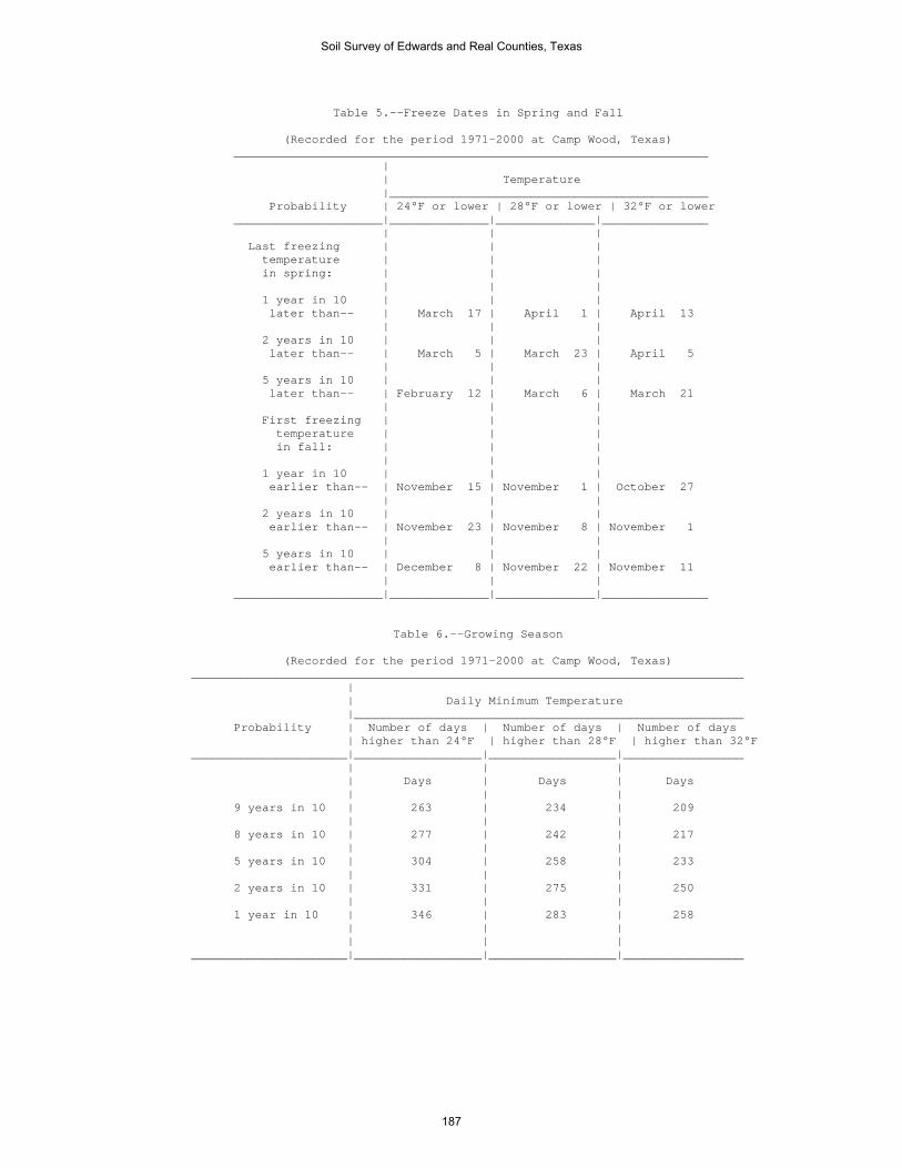
Table 5.--Freeze Dates in Spring and Fall
(Recorded for the period 1971-2000 at Camp Wood, Texas) ___________________________________________________________________ | | Temperature |_____________________________________________ Probability | 24°F or lower | 28°F or lower | 32°F or lower _____________________|______________|______________|_______________ | | | Last freezing | | | temperature | | | in spring: | | | | | | 1 year in 10 | | | later than-- | March 17 | April 1 | April 13 | | | 2 years in 10 | | | later than-- | March 5 | March 23 | April 5 | | | 5 years in 10 | | | later than-- | February 12 | March 6 | March 21 | | | First freezing | | | temperature | | | in fall: | | | | | | 1 year in 10 | | | earlier than-- | November 15 | November 1 | October 27 | | | 2 years in 10 | | | earlier than-- | November 23 | November 8 | November 1 | | | 5 years in 10 | | | earlier than-- | December 8 | November 22 | November 11 | | | _____________________|______________|______________|_______________
Table 6.--Growing Season
(Recorded for the period 1971-2000 at Camp Wood, Texas) ______________________________________________________________________________ | | Daily Minimum Temperature |_______________________________________________________ Probability | Number of days | Number of days | Number of days | higher than 24°F | higher than 28°F | higher than 32°F ______________________|__________________|__________________|_________________ | | | | Days | Days | Days | | | 9 years in 10 | 263 | 234 | 209 | | | 8 years in 10 | 277 | 242 | 217 | | | 5 years in 10 | 304 | 258 | 233 | | | 2 years in 10 | 331 | 275 | 250 | | | 1 year in 10 | 346 | 283 | 258 | | | | | | ______________________|__________________|__________________|_________________
Soil Survey of Edwards and Real Counties, Texas
187

Table 7.--Acreage and Proportionate Extent of the Soils _______________________________________________________________________________________________ | | | | Total Map | Soil name | Edwards | Real |___________________ symbol | | County | County | Area | Extent _______|_____________________________________________|__________|__________|__________|________ | | Acres | Acres | Acres | Pct | | | | | CkB |Campwood-Knippa complex, 0 to 3 percent | | | | | slopes--------------------------------------| 5,953 | 13,069 | 19,022 | 1.1 CoB |Cho-Angelo complex, limestone substratum, 0 | | | | | to 2 percent slopes-------------------------| 4,817 | --- | 4,817 | 0.3 DeB |Dev-Riverwash complex, 0 to 3 percent slopes,| | | | | frequently flooded--------------------------| 33,055 | 15,151 | 48,206 | 2.7 DnD |Dina-Eckrant complex, 1 to 8 percent slopes--| 30,747 | 21,796 | 52,543 | 2.9 EcF |Eckrant-Rock outcrop complex, 1 to 20 percent| | | | | slopes--------------------------------------| 637,236 | 116,162 | 753,398 | 41.7 EcG |Eckrant-Rock outcrop complex, 20 to 60 | | | | | percent slopes------------------------------| 89,592 | 186,390 | 275,982 | 15.3 ErB |Ector gravelly silty clay loam, 1 to 3 | | | | | percent slopes------------------------------| 7,364 | --- | 7,364 | 0.4 ErF |Ector-Rock outcrop complex, 1 to 20 percent | | | | | slopes--------------------------------------| 21,151 | --- | 21,151 | 1.2 ErG |Ector-Rock outcrop complex, 20 to 60 percent | | | | | slopes--------------------------------------| 121,081 | --- | 121,081 | 6.7 IrA |Irion clay, 0 to 1 percent slopes------------| 280 | 10 | 290 | * KrD |Kerrville-Real complex, 1 to 8 percent slopes| 1,637 | 4,872 | 6,509 | 0.4 KrF |Kerrville-Real complex, 8 to 40 percent | | | | | slopes--------------------------------------| 43 | 869 | 912 | * LaE |Langtry-Rock outcrop complex, 1 to 15 percent| | | | | slopes--------------------------------------| 71 | --- | 71 | * LkB |Leakey silty clay loam, 1 to 3 percent slopes| 629 | 5,445 | 6,074 | 0.3 MaD |Mailtrail very gravelly clay loam, 1 to 8 | | | | | percent slopes------------------------------| 37,979 | 1,418 | 39,397 | 2.2 MmC |Mailtrail-Mereta complex, 0 to 5 percent | | | | | slopes--------------------------------------| 9,995 | 22,040 | 32,035 | 1.8 NuB |Nuvalde clay loam, 1 to 3 percent slopes, | | | | | rarely flooded------------------------------| 7,262 | 3,547 | 10,809 | 0.6 OdA |Oakalla-Dev complex, 0 to 2 percent slopes, | | | | | flooded-------------------------------------| 6,505 | 1,601 | 8,106 | 0.4 OrA |Orif soils, frequently flooded---------------| --- | 518 | 518 | * OrG |Oplin-Rock outcrop complex, 20 to 60 percent | | | | | slopes--------------------------------------| 103,087 | 489 | 103,576 | 5.7 PeB |Prade-Eckrant complex, 0 to 3 percent slopes-| 88,992 | 5,213 | 94,205 | 5.2 PIT |Pits-----------------------------------------| 13 | 11 | 24 | * PrC |Prade-Tarrant complex, 2 to 5 percent slopes-| 23,248 | 8,299 | 31,547 | 1.7 PtB |Pratley clay, 1 to 3 percent slopes----------| 706 | 6,193 | 6,899 | 0.4 RaF |Real-Oplin complex, 1 to 20 percent slopes---| 13,951 | 23,380 | 37,331 | 2.1 RdB |Rio Diablo silty clay, 0 to 2 percent slopes,| | | | | rarely flooded------------------------------| 28,115 | --- | 28,115 | 1.6 RfB |Rio Frio-Vanderpool complex, 0 to 2 percent | | | | | slopes, rarely flooded----------------------| 776 | 2,398 | 3,174 | 0.2 RsB |Riverwash and Dev soils, 0 to 3 percent | | | | | slopes, frequently flooded------------------| 2,147 | 1,056 | 3,203 | 0.2 RtG |Rock outcrop-Langtry complex, 15 to 60 | | | | | percent slopes------------------------------| 2,272 | --- | 2,272 | 0.1 StC |Spires-Tarpley complex, 1 to 5 percent slopes| --- | 2,421 | 2,421 | 0.1 TeA |Tarrant-Eckrant complex, 0 to 2 percent | | | | | slopes--------------------------------------| 22,581 | 3,138 | 25,719 | 1.4 TvB |Tarrant-Valera complex, 0 to 3 percent slopes| 42,042 | 1,586 | 43,628 | 2.4 VaA |Valera clay, 0 to 2 percent slopes-----------| 13,798 | 738 | 14,536 | 0.8 W |Water----------------------------------------| 59 | 43 | 102 | * | |__________|__________|__________|________ | Total-----------------------------------|1,357,184 | 447,853 |1,805,037 | 100.0 _______|_____________________________________________|__________|__________|__________|________ * Less than 0.1 percent.
Soil Survey of Edwards and Real Counties, Texas
188
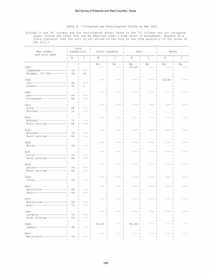
Table 8.--Irrigated and Nonirrigated Yields by Map Unit (Yields in the "N" columns are for nonirrigated areas; those in the "I" columns are for irrigated areas. Yields are those that can be expected under a high level of management. Absence of a yield indicates that the soil is not suited to the crop or the crop generally is not grown on the soil.) ___________________________________________________________________________________________________ | Land | | | Map symbol | capability | Grain sorghum | Oats | Wheat and soil name |_____________|___________________|___________________|___________________ | N | I | N | I | N | I | N | I _________________________|______|______|_________|_________|_________|_________|_________|_________ | | | Bu | Bu | Bu | Bu | Bu | Bu CkB: | | | --- | --- | 70.00 | --- | --- | --- Campwood----------------| 2e | --- | | | | | | Knippa, >27 PZ----------| 3e | 2e | | | | | | | | | | | | | | CoB: | | | --- | --- | --- | --- | 15.00 | --- Cho---------------------| 4s | --- | | | | | | Angelo------------------| 3c | 1 | | | | | | | | | | | | | | DeB: | | | --- | --- | --- | --- | --- | --- Dev---------------------| 6w | --- | | | | | | Riverwash---------------| 8w | --- | | | | | | | | | | | | | | DnD: | | | --- | --- | --- | --- | --- | --- Dina--------------------| 6s | --- | | | | | | Eckrant-----------------| 7s | --- | | | | | | | | | | | | | | EcF: | | | --- | --- | --- | --- | --- | --- Eckrant-----------------| 7s | --- | | | | | | Rock outcrop------------| 8s | --- | | | | | | | | | | | | | | EcG: | | | --- | --- | --- | --- | --- | --- Eckrant-----------------| 7s | --- | | | | | | Rock outcrop------------| 8s | --- | | | | | | | | | | | | | | ErB: | | | --- | --- | --- | --- | --- | --- Ector-------------------| 7s | --- | | | | | | | | | | | | | | ErF: | | | --- | --- | --- | --- | --- | --- Ector-------------------| 7s | --- | | | | | | Rock outcrop------------| 8s | --- | | | | | | | | | | | | | | ErG: | | | --- | --- | --- | --- | --- | --- Ector-------------------| 7s | --- | | | | | | Rock outcrop------------| 8s | --- | | | | | | | | | | | | | | IrA: | | | --- | --- | --- | --- | --- | --- Irion-------------------| 2s | --- | | | | | | | | | | | | | | KrD: | | | --- | --- | --- | --- | --- | --- Kerrville---------------| 4e | --- | | | | | | Real--------------------| 6s | --- | | | | | | | | | | | | | | KrF: | | | --- | --- | --- | --- | --- | --- Kerrville---------------| 7s | --- | | | | | | Real--------------------| 7s | --- | | | | | | | | | | | | | | LaE: | | | --- | --- | --- | --- | --- | --- Langtry-----------------| 7s | --- | | | | | | Rock outcrop------------| 8s | --- | | | | | | | | | | | | | | LkB: | | | 30.00 | --- | 30.00 | --- | --- | --- Leakey------------------| 3e | --- | | | | | | | | | | | | | | MaD: | | | --- | --- | --- | --- | --- | --- Mailtrail---------------| 7s | --- | | | | | | | | | | | | | |
Soil Survey of Edwards and Real Counties, Texas
189

Table 8.--Irrigated and Nonirrigated Yields by Map Unit--Continued ___________________________________________________________________________________________________ | Land | | | Map symbol | capability | Grain sorghum | Oats | Wheat and soil name |_____________|___________________|___________________|___________________ | N | I | N | I | N | I | N | I _________________________|______|______|_________|_________|_________|_________|_________|_________ | | | Bu | Bu | Bu | Bu | Bu | Bu MmC: | | | --- | --- | --- | --- | --- | --- Mailtrail---------------| 7s | --- | | | | | | Mereta------------------| 3s | 3s | | | | | | | | | | | | | | NuB: | | | 35.00 | 110.00 | 50.00 | --- | 20.00 | 50.00 Nuvalde-----------------| 2e | 2e | | | | | | | | | | | | | | OdA: | | | 65.00 | --- | 60.00 | --- | 25.00 | --- Oakalla, >27 PZ---------| 2w | --- | | | | | | Dev---------------------| 6w | --- | | | | | | | | | | | | | | OrA: | | | --- | --- | --- | --- | --- | --- Orif--------------------| 6s | --- | | | | | | | | | | | | | | OrG: | | | --- | --- | --- | --- | --- | --- Oplin-------------------| 7s | --- | | | | | | Rock outcrop------------| 8s | --- | | | | | | | | | | | | | | PeB: | | | --- | --- | --- | --- | --- | --- Prade-------------------| 7s | --- | | | | | | Eckrant-----------------| 7s | --- | | | | | | | | | | | | | | PIT: | | | --- | --- | --- | --- | --- | --- Pits--------------------| 8s | --- | | | | | | | | | | | | | | PrC: | | | --- | --- | --- | --- | --- | --- Prade-------------------| 7s | --- | | | | | | Tarrant, <31 PZ---------| 7s | --- | | | | | | | | | | | | | | PtB: | | | 35.00 | 85.00 | 40.00 | --- | --- | --- Pratley-----------------| 2e | 2e | | | | | | | | | | | | | | RaF: | | | --- | --- | --- | --- | --- | --- Real--------------------| 6s | --- | | | | | | Oplin-------------------| 7s | --- | | | | | | | | | | | | | | RdB: | | | --- | --- | --- | --- | --- | --- Rio Diablo--------------| 3c | 2e | | | | | | | | | | | | | | RfB: | | | --- | --- | --- | --- | --- | --- Rio Frio----------------| 3s | 2s | | | | | | Vanderpool--------------| 3e | 2e | | | | | | | | | | | | | | RsB: | | | --- | --- | --- | --- | --- | --- Riverwash---------------| 8w | --- | | | | | | Dev---------------------| 6w | --- | | | | | | | | | | | | | | RtG: | | | --- | --- | --- | --- | --- | --- Rock outcrop------------| 8s | --- | | | | | | Langtry-----------------| 7s | --- | | | | | | | | | | | | | | StC: | | | --- | --- | --- | --- | --- | --- Spires------------------| 4e | --- | | | | | | Tarpley-----------------| 6s | --- | | | | | | | | | | | | | | TeA: | | | --- | --- | --- | --- | --- | --- Tarrant, <31 PZ---------| 7s | --- | | | | | | Eckrant-----------------| 7s | --- | | | | | | | | | | | | | | TvB: | | | --- | --- | --- | --- | --- | --- Tarrant, <31 PZ---------| 7s | --- | | | | | | Valera------------------| 2s | --- | | | | | | | | | | | | | |
Soil Survey of Edwards and Real Counties, Texas
190
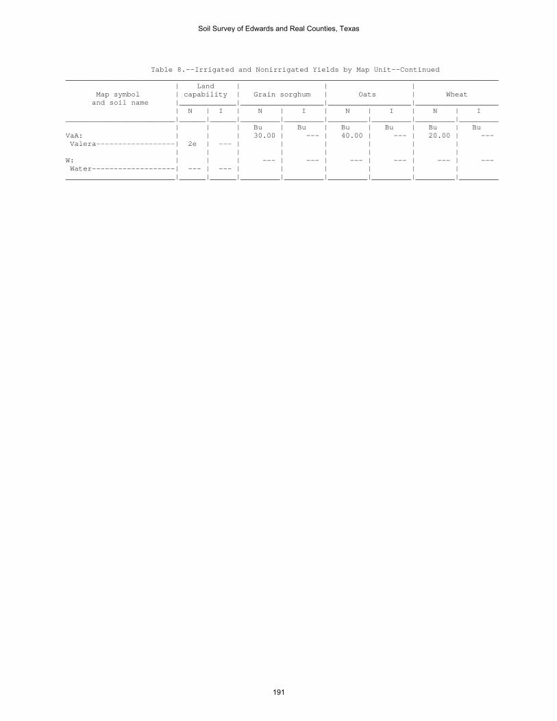
Table 8.--Irrigated and Nonirrigated Yields by Map Unit--Continued ___________________________________________________________________________________________________ | Land | | | Map symbol | capability | Grain sorghum | Oats | Wheat and soil name |_____________|___________________|___________________|___________________ | N | I | N | I | N | I | N | I _________________________|______|______|_________|_________|_________|_________|_________|_________ | | | Bu | Bu | Bu | Bu | Bu | Bu VaA: | | | 30.00 | --- | 40.00 | --- | 20.00 | --- Valera------------------| 2e | --- | | | | | | | | | | | | | | W: | | | --- | --- | --- | --- | --- | --- Water-------------------| --- | --- | | | | | | _________________________|______|______|_________|_________|_________|_________|_________|_________
Soil Survey of Edwards and Real Counties, Texas
191

Table 9.--Prime and Other Important Farmland (Only the soils considered prime or important farmland are listed. Urban or built-up areas of the soils listed are not considered prime or important farmland. If a soil is prime or important farmland only under certain conditions, the conditions are specified in parentheses after the soil name.) ________________________________________________________________________________________________________ | | Map | Map unit name | Farmland classification Symbol | | ________________________________________________________________________________________________________ | | CkB |Campwood-Knippa complex, 0 to 3 percent slopes |Prime farmland if irrigated IrA |Irion clay, 0 to 1 percent slopes |Prime farmland if irrigated NuB |Nuvalde clay loam, 1 to 3 percent slopes, rarely flooded |Prime farmland if irrigated RdB |Rio Diablo silty clay, 0 to 2 percent slopes, rarely flooded |Prime farmland if irrigated VaA |Valera clay, 0 to 2 percent slopes |Prime farmland if irrigated ________________________________________________________________________________________________________
Soil Survey of Edwards and Real Counties, Texas
192

Table 10.--Rangeland Productivity
(Only the soils that support rangeland vegetation suitable for grazing are rated.) ______________________________________________________________________________________________________ | | Total dry-weight production Map symbol | Ecological site |___________________________________ and soil name | | Favorable | Normal |Unfavorable | | year | year | year ___________________________________|______________________________|___________|___________|___________ | | Lb/acre | Lb/acre | Lb/acre CkB: | | | | Campwood--------------------------|Clay Loam 29-35" PZ | 6,000 | 4,500 | 3,000 Knippa, >27 PZ--------------------|Clay Loam 29-35" PZ | 6,500 | 5,000 | 3,500 | | | | CoB: | | | | Cho-------------------------------|Very Shallow 23-31" PZ | 2,500 | 2,000 | 1,000 Angelo----------------------------|Clay Loam 19-23" PZ | 4,000 | 3,000 | 2,000 | | | | DeB: | | | | Dev-------------------------------|Draw 19-31" PZ | 3,000 | 2,000 | 1,000 Riverwash-------------------------| --- | --- | --- | --- | | | | DnD: | | | | Dina------------------------------|Gravelly Redland 29-35" PZ | 4,200 | 3,700 | 2,000 Eckrant---------------------------|Low Stony Hill 29-35" PZ | 3,000 | 2,500 | 1,500 | | | | EcF: | | | | Eckrant---------------------------|Low Stony Hill 23-31" PZ | 3,000 | 2,500 | 1,500 Rock outcrop----------------------| --- | --- | --- | --- | | | | EcG: | | | | Eckrant---------------------------|Steep Rocky 29-35" PZ | 1,800 | 1,400 | 800 Rock outcrop----------------------| --- | --- | --- | --- | | | | ErB: | | | | Ector-----------------------------|Limestone Hill 19-23" PZ | 1,900 | 1,500 | 600 | | | | ErF: | | | | Ector-----------------------------|Limestone Hill 19-23" PZ | 2,300 | 1,900 | 800 Rock outcrop----------------------| --- | --- | --- | --- | | | | ErG: | | | | Ector-----------------------------|Steep Rocky 19-23" PZ | 2,200 | 1,800 | 800 Rock outcrop----------------------| --- | --- | --- | --- | | | | IrA: | | | | Irion-----------------------------|Clay Flat 14-19" PZ | 3,000 | 1,500 | 500 | | | | KrD: | | | | Kerrville-------------------------|Adobe 29-35" PZ | 3,500 | 2,800 | 1,500 Real------------------------------|Adobe 29-35" PZ | 3,500 | 2,500 | 1,500 | | | | KrF: | | | | Kerrville-------------------------|Steep Adobe 29-35" PZ | 3,000 | 2,000 | 1,200 Real------------------------------|Steep Adobe 29-35" PZ | 3,000 | 2,200 | 1,500 | | | | LaE: | | | | Langtry---------------------------|Limestone Hill 14-19" PZ | 1,700 | 1,350 | 1,000 Rock outcrop----------------------| --- | --- | --- | --- | | | | LkB: | | | | Leakey----------------------------|Deep Redland 29-35" PZ | 5,000 | 3,500 | 2,000 | | | | MaD: | | | | Mailtrail-------------------------|Very Shallow 23-31" PZ | 2,700 | 1,800 | 1,300 | | | | MmC: | | | | Mailtrail-------------------------|Very Shallow 23-31" PZ | 2,700 | 1,800 | 1,300 Mereta----------------------------|Shallow 23-31" PZ | 3,500 | 2,800 | 1,800 | | | |
Soil Survey of Edwards and Real Counties, Texas
193

Table 10.--Rangeland Productivity--Continued ______________________________________________________________________________________________________ | | Total dry-weight production Map symbol | Ecological site |___________________________________ and soil name | | Favorable | Normal |Unfavorable | | year | year | year ___________________________________|______________________________|___________|___________|___________ | | Lb/acre | Lb/acre | Lb/acre NuB: | | | | Nuvalde---------------------------|Clay Loam 23-31" PZ | 4,500 | 3,500 | 2,000 | | | | OdA: | | | | Oakalla, >27 PZ-------------------|Loamy Bottomland 29-35" PZ | 7,000 | 5,500 | 3,500 Dev-------------------------------|Draw 19-31" PZ | 3,000 | 2,000 | 1,000 | | | | OrA: | | | | Orif------------------------------|Loamy Bottomland 29-35" PZ | 3,800 | 3,200 | 2,000 | | | | OrG: | | | | Oplin-----------------------------|Steep Rocky 23-31" PZ | 1,700 | 1,300 | 900 Rock outcrop----------------------| --- | --- | --- | --- | | | | PeB: | | | | Prade-----------------------------|Very Shallow 23-31" PZ | 2,500 | 2,000 | 1,000 Eckrant---------------------------|Low Stony Hill 23-31" PZ | 3,000 | 2,500 | 1,500 | | | | PIT: | | | | Pits------------------------------| --- | --- | --- | --- | | | | PrC: | | | | Prade-----------------------------|Very Shallow 23-31" PZ | 2,500 | 2,000 | 1,000 Tarrant, <31 PZ-------------------|Low Stony Hill 23-31" PZ | 2,500 | 1,800 | 1,200 | | | | PtB: | | | | Pratley---------------------------|Clay Loam 29-35" PZ | 5,000 | 3,500 | 2,500 | | | | RaF: | | | | Real------------------------------|Adobe 29-35" PZ | 3,500 | 2,500 | 1,500 Oplin-----------------------------|Low Stony Hill 23-31" PZ | 2,000 | 1,500 | 1,000 | | | | RdB: | | | | Rio Diablo------------------------|Clay Loam 23-31" PZ | 3,800 | 3,000 | 1,900 | | | | RfB: | | | | Rio Frio--------------------------|Clay Loam 29-35" PZ | 5,200 | 3,800 | 2,600 Vanderpool------------------------|Clay Loam 29-35" PZ | 5,500 | 4,000 | 2,700 | | | | RsB: | | | | Riverwash-------------------------| --- | --- | --- | --- Dev-------------------------------|Draw 19-31" PZ | 3,000 | 2,000 | 1,000 | | | | RtG: | | | | Rock outcrop----------------------| --- | --- | --- | --- Langtry---------------------------|Steep Rocky 14-19" PZ | 1,500 | 1,100 | 900 | | | | StC: | | | | Spires----------------------------|Deep Redland 29-35" PZ | 5,500 | 4,200 | 2,500 Tarpley---------------------------|Redland 29-35" PZ | 5,000 | 3,500 | 2,000 | | | | TeA: | | | | Tarrant, <31 PZ-------------------|Low Stony Hill 23-31" PZ | 2,500 | 1,800 | 1,200 Eckrant---------------------------|Low Stony Hill 23-31" PZ | 3,000 | 2,500 | 1,500 | | | | TvB: | | | | Tarrant, <31 PZ-------------------|Low Stony Hill 23-31" PZ | 2,500 | 1,800 | 1,200 Valera----------------------------|Clay Loam 23-31" PZ | 4,500 | 3,000 | 2,000 | | | |
Soil Survey of Edwards and Real Counties, Texas
194

Table 10.--Rangeland Productivity--Continued (Only the soils that support rangeland vegetation suitable for grazing are rated.) ______________________________________________________________________________________________________ | | Total dry-weight production Map symbol | Ecological site |___________________________________ and soil name | | Favorable | Normal |Unfavorable | | year | year | year ___________________________________|______________________________|___________|___________|___________ | | Lb/acre | Lb/acre | Lb/acre VaA: | | | | Valera----------------------------|Clay Loam 23-31" PZ | 4,500 | 3,000 | 2,000 | | | | W: | | | | Water-----------------------------| --- | --- | --- | --- ___________________________________|______________________________|___________|___________|___________
Soil Survey of Edwards and Real Counties, Texas
195

Table 11.--Grain and Seed Crops, Grasses and Legumes, and Irrigated Grain and Seed Crops (The information in this table indicates the dominant soil condition but does not eliminate the need for onsite investigation. The numbers in the value columns range from 0.01 to 1.00. The larger the value, the greater the limitation. See text for further explanation of ratings in this table.) ________________________________________________________________________________________________________ | | | | Map symbol |Pct.|Grain and seed crops for | Domestic grasses and |Irrigated grain and seed and soil name | of | food and | legumes for food and | crops for food and |map | cover | cover | cover |unit| | | | |_________________________|_________________________|_________________________ | | Rating class and |Value| Rating class and |Value| Rating class and |Value | | limiting features | | limiting features | | limiting features | _____________________|____|___________________|_____|___________________|_____|___________________|_____ CkB: | | | | | | | Campwood------------| 53 |Very limited | |Very limited | |Very limited | | | HEL wind |1.00 | Too clayey |1.00 | HEL wind |1.00 | | Too clayey |1.00 | Percs slowly |0.17 | Too clayey |1.00 | | Percs slowly |0.17 | | | Percs slowly |0.17 | | Droughty |0.08 | | | Droughty |0.08 | | | | | | | Knippa, >27 PZ------| 30 |Very limited | |Very limited | |Very limited | | | HEL wind |1.00 | Too clayey |1.00 | HEL wind |1.00 | | Too clayey |1.00 | | | Too clayey |1.00 | | | | | | | CoB: | | | | | | | Cho-----------------| 33 |Very limited | |Very limited | |Very limited | | | Droughty |1.00 | Droughty |1.00 | Droughty |1.00 | | Cemented pan |1.00 | Cemented pan |1.00 | Cemented pan |1.00 | | Too gravelly, |0.29 | Too gravelly, |0.29 | Too gravelly, |0.29 | | cobbly, or stony| | cobbly, or stony| | cobbly, or stony| | | | | | | | Angelo--------------| 29 |Somewhat limited | |Somewhat limited | |Somewhat limited | | | Too arid |0.50 | Too arid |0.50 | Too clayey |0.30 | | Too clayey |0.30 | Too clayey |0.30 | | | | | | | | | DeB: | | | | | | | Dev-----------------| 60 |Very limited | |Very limited | |Very limited | | | Droughty |1.00 | Too gravelly, |1.00 | Flooding |1.00 | | | | cobbly, or stony| | | | | Too gravelly, |1.00 | Flooding |0.50 | Droughty |1.00 | | cobbly, or stony| | | | | | | Flooding |0.50 | Droughty |0.15 | Too gravelly, |1.00 | | | | | | cobbly, or stony| | | | | | | | Riverwash-----------| 25 |Not rated | |Not rated | |Not rated | | | | | | | | DnD: | | | | | | | Dina----------------| 60 |Very limited | |Very limited | |Very limited | | | Droughty |1.00 | Potentially or |1.00 | Droughty |1.00 | | | | highly erodible | | | | | Potentially or |1.00 | Droughty |1.00 | Potentially or |1.00 | | highly erodible | | | | highly erodible | | | Too gravelly, |0.99 | Too gravelly, |0.99 | Too gravelly, |0.99 | | cobbly, or stony| | cobbly, or stony| | cobbly, or stony| | | Bedrock |0.29 | Bedrock |0.29 | Bedrock |0.29 | | Too clayey |0.11 | Too clayey |0.11 | Too clayey |0.11 | | | | | | | Eckrant-------------| 30 |Very limited | |Very limited | |Very limited | | | Droughty |1.00 | Droughty |1.00 | Droughty |1.00 | | Bedrock |1.00 | Potentially or |1.00 | Bedrock |1.00 | | | | highly erodible | | | | | Too clayey |1.00 | Bedrock |1.00 | Too clayey |1.00 | | Potentially or |1.00 | Too clayey |1.00 | Potentially or |1.00 | | highly erodible | | | | highly erodible | | | Too gravelly, |1.00 | Too gravelly, |1.00 | Too gravelly, |1.00 | | cobbly, or stony| | cobbly, or stony| | cobbly, or stony| | | | | | | |
Soil Survey of Edwards and Real Counties, Texas
196

Table 11.--Grain and Seed Crops, Grasses and Legumes, and Irrigated Grain and Seed Crops--Continued ________________________________________________________________________________________________________ | | | | Map symbol |Pct.|Grain and seed crops for | Domestic grasses and |Irrigated grain and seed and soil name | of | food and | legumes for food and | crops for food and |map | cover | cover | cover |unit| | | | |_________________________|_________________________|_________________________ | | Rating class and |Value| Rating class and |Value| Rating class and |Value | | limiting features | | limiting features | | limiting features | _____________________|____|___________________|_____|___________________|_____|___________________|_____ EcF: | | | | | | | Eckrant-------------| 67 |Very limited | |Very limited | |Very limited | | | Droughty |1.00 | Droughty |1.00 | Droughty |1.00 | | Bedrock |1.00 | Potentially or |1.00 | Bedrock |1.00 | | | | highly erodible | | | | | Too clayey |1.00 | Bedrock |1.00 | Too clayey |1.00 | | Potentially or |1.00 | Too clayey |1.00 | Potentially or |1.00 | | highly erodible | | | | highly erodible | | | Too gravelly, |1.00 | Too gravelly, |1.00 | Too gravelly, |1.00 | | cobbly, or stony| | cobbly, or stony| | cobbly, or stony| | | | | | | | Rock outcrop--------| 13 |Not rated | |Not rated | |Not rated | | | | | | | | EcG: | | | | | | | Eckrant-------------| 50 |Very limited | |Very limited | |Very limited | | | Droughty |1.00 | Droughty |1.00 | Droughty |1.00 | | Bedrock |1.00 | Potentially or |1.00 | Slope |1.00 | | | | highly erodible | | | | | Too clayey |1.00 | Bedrock |1.00 | Bedrock |1.00 | | Potentially or |1.00 | Too clayey |1.00 | Too clayey |1.00 | | highly erodible | | | | | | | Slope |1.00 | Slope |1.00 | Potentially or |1.00 | | | | | | highly erodible | | | | | | | | Rock outcrop--------| 33 |Not rated | |Not rated | |Not rated | | | | | | | | ErB: | | | | | | | Ector---------------| 90 |Very limited | |Very limited | |Very limited | | | Droughty |1.00 | Droughty |1.00 | Droughty |1.00 | | Bedrock |1.00 | Potentially or |1.00 | Bedrock |1.00 | | | | highly erodible | | | | | Potentially or |1.00 | Bedrock |1.00 | Potentially or |1.00 | | highly erodible | | | | highly erodible | | | Too gravelly, |0.99 | Too gravelly, |0.99 | Too gravelly, |0.99 | | cobbly, or stony| | cobbly, or stony| | cobbly, or stony| | | Too clayey |0.01 | Too clayey |0.01 | Too clayey |0.01 | | | | | | | ErF: | | | | | | | Ector---------------| 71 |Very limited | |Very limited | |Very limited | | | Droughty |1.00 | Droughty |1.00 | Droughty |1.00 | | Bedrock |1.00 | Potentially or |1.00 | Bedrock |1.00 | | | | highly erodible | | | | | Potentially or |1.00 | Bedrock |1.00 | Potentially or |1.00 | | highly erodible | | | | highly erodible | | | Too gravelly, |1.00 | Too gravelly, |1.00 | Too gravelly, |1.00 | | cobbly, or stony| | cobbly, or stony| | cobbly, or stony| | | | | | | Slope |1.00 | | | | | | | Rock outcrop--------| 16 |Not rated | |Not rated | |Not rated | | | | | | | |
Soil Survey of Edwards and Real Counties, Texas
197

Table 11.--Grain and Seed Crops, Grasses and Legumes, and Irrigated Grain and Seed Crops--Continued ________________________________________________________________________________________________________ | | | | Map symbol |Pct.|Grain and seed crops for | Domestic grasses and |Irrigated grain and seed and soil name | of | food and | legumes for food and | crops for food and |map | cover | cover | cover |unit| | | | |_________________________|_________________________|_________________________ | | Rating class and |Value| Rating class and |Value| Rating class and |Value | | limiting features | | limiting features | | limiting features | _____________________|____|___________________|_____|___________________|_____|___________________|_____ ErG: | | | | | | | Ector---------------| 61 |Very limited | |Very limited | |Very limited | | | Droughty |1.00 | Droughty |1.00 | Droughty |1.00 | | Bedrock |1.00 | Potentially or |1.00 | Slope |1.00 | | | | highly erodible | | | | | Potentially or |1.00 | Bedrock |1.00 | Bedrock |1.00 | | highly erodible | | | | | | | Slope |1.00 | Slope |1.00 | Potentially or |1.00 | | | | | | highly erodible | | | Too gravelly, |1.00 | Too gravelly, |1.00 | Too gravelly, |1.00 | | cobbly, or stony| | cobbly, or stony| | cobbly, or stony| | | | | | | | Rock outcrop--------| 35 |Not rated | |Not rated | |Not rated | | | | | | | | IrA: | | | | | | | Irion---------------| 90 |Very limited | |Very limited | |Very limited | | | Ponding |1.00 | Ponding |1.00 | Ponding |1.00 | | HEL wind |1.00 | Too clayey |1.00 | HEL wind |1.00 | | Too clayey |1.00 | Percs slowly |0.50 | Too clayey |1.00 | | Percs slowly |0.50 | | | Percs slowly |0.50 | | | | | | | KrD: | | | | | | | Kerrville-----------| 54 |Very limited | |Very limited | |Very limited | | | Droughty |1.00 | Potentially or |1.00 | Droughty |1.00 | | | | highly erodible | | | | | Potentially or |1.00 | Droughty |0.93 | Potentially or |1.00 | | highly erodible | | | | highly erodible | | | Bedrock |0.20 | Bedrock |0.20 | Bedrock |0.20 | | | | | | Slope |0.12 | | | | | | | Real----------------| 26 |Very limited | |Very limited | |Very limited | | | Droughty |1.00 | Droughty |1.00 | Droughty |1.00 | | Bedrock |1.00 | Potentially or |1.00 | Bedrock |1.00 | | | | highly erodible | | | | | Potentially or |1.00 | Bedrock |1.00 | Potentially or |1.00 | | highly erodible | | | | highly erodible | | | Too gravelly, |1.00 | Too gravelly, |1.00 | Too gravelly, |1.00 | | cobbly, or stony| | cobbly, or stony| | cobbly, or stony| | | | | | | Slope |0.12 | | | | | | | KrF: | | | | | | | Kerrville-----------| 60 |Very limited | |Very limited | |Very limited | | | Potentially or |1.00 | Potentially or |1.00 | Slope |1.00 | | highly erodible | | highly erodible | | | | | Droughty |1.00 | Slope |0.68 | Potentially or |1.00 | | | | | | highly erodible | | | Slope |0.68 | Droughty |0.11 | Droughty |1.00 | | Bedrock |0.06 | Bedrock |0.06 | Bedrock |0.06 | | | | | | | Real----------------| 21 |Very limited | |Very limited | |Very limited | | | Droughty |1.00 | Droughty |1.00 | Droughty |1.00 | | Bedrock |1.00 | Potentially or |1.00 | Slope |1.00 | | | | highly erodible | | | | | Potentially or |1.00 | Bedrock |1.00 | Bedrock |1.00 | | highly erodible | | | | | | | Too gravelly, |1.00 | Too gravelly, |1.00 | Potentially or |1.00 | | cobbly, or stony| | cobbly, or stony| | highly erodible | | | Slope |0.68 | Slope |0.68 | Too gravelly, |1.00 | | | | | | cobbly, or stony| | | | | | | |
Soil Survey of Edwards and Real Counties, Texas
198

Table 11.--Grain and Seed Crops, Grasses and Legumes, and Irrigated Grain and Seed Crops--Continued ________________________________________________________________________________________________________ | | | | Map symbol |Pct.|Grain and seed crops for | Domestic grasses and |Irrigated grain and seed and soil name | of | food and | legumes for food and | crops for food and |map | cover | cover | cover |unit| | | | |_________________________|_________________________|_________________________ | | Rating class and |Value| Rating class and |Value| Rating class and |Value | | limiting features | | limiting features | | limiting features | _____________________|____|___________________|_____|___________________|_____|___________________|_____ LaE: | | | | | | | Langtry-------------| 72 |Very limited | |Very limited | |Very limited | | | Droughty |1.00 | Droughty |1.00 | Droughty |1.00 | | Bedrock |1.00 | Potentially or |1.00 | Bedrock |1.00 | | | | highly erodible | | | | | Potentially or |1.00 | Bedrock |1.00 | Potentially or |1.00 | | highly erodible | | | | highly erodible | | | Too gravelly, |1.00 | Too gravelly, |1.00 | Too gravelly, |1.00 | | cobbly, or stony| | cobbly, or stony| | cobbly, or stony| | | | | | | Slope |1.00 | | | | | | | Rock outcrop--------| 10 |Not rated | |Not rated | |Not rated | | | | | | | | LkB: | | | | | | | Leakey--------------| 73 |Very limited | |Very limited | |Very limited | | | HEL wind |1.00 | Potentially or |1.00 | HEL wind |1.00 | | | | highly erodible | | | | | Potentially or |1.00 | Cemented pan |0.74 | Potentially or |1.00 | | highly erodible | | | | highly erodible | | | Droughty |1.00 | Too clayey |0.70 | Droughty |1.00 | | Cemented pan |0.74 | Percs slowly |0.50 | Cemented pan |0.74 | | Too clayey |0.70 | Droughty |0.02 | Too clayey |0.70 | | | | | | | MaD: | | | | | | | Mailtrail-----------| 67 |Very limited | |Very limited | |Very limited | | | Droughty |1.00 | Droughty |1.00 | Droughty |1.00 | | Cemented pan |1.00 | Cemented pan |1.00 | Cemented pan |1.00 | | Too gravelly, |1.00 | Too gravelly, |1.00 | Too gravelly, |1.00 | | cobbly, or stony| | cobbly, or stony| | cobbly, or stony| | | | | | | Slope |0.12 | | | | | | | MmC: | | | | | | | Mailtrail-----------| 55 |Very limited | |Very limited | |Very limited | | | Droughty |1.00 | Droughty |1.00 | Droughty |1.00 | | Potentially or |1.00 | Potentially or |1.00 | Potentially or |1.00 | | highly erodible | | highly erodible | | highly erodible | | | Cemented pan |1.00 | Cemented pan |1.00 | Cemented pan |1.00 | | Too gravelly, |1.00 | Too gravelly, |1.00 | Too gravelly, |1.00 | | cobbly, or stony| | cobbly, or stony| | cobbly, or stony| | | | | | | | Mereta--------------| 30 |Very limited | |Very limited | |Very limited | | | Droughty |1.00 | Potentially or |1.00 | Droughty |1.00 | | | | highly erodible | | | | | Potentially or |1.00 | Cemented pan |1.00 | Potentially or |1.00 | | highly erodible | | | | highly erodible | | | Cemented pan |1.00 | Too clayey |0.57 | Cemented pan |1.00 | | Too clayey |0.57 | Droughty |0.15 | Too clayey |0.57 | | | | | | | NuB: | | | | | | | Nuvalde-------------| 90 |Very limited | |Somewhat limited | |Very limited | | | HEL wind |1.00 | Too clayey |0.43 | HEL wind |1.00 | | Too clayey |0.43 | | | Too clayey |0.43 | | | | | | |
Soil Survey of Edwards and Real Counties, Texas
199

Table 11.--Grain and Seed Crops, Grasses and Legumes, and Irrigated Grain and Seed Crops--Continued ________________________________________________________________________________________________________ | | | | Map symbol |Pct.|Grain and seed crops for | Domestic grasses and |Irrigated grain and seed and soil name | of | food and | legumes for food and | crops for food and |map | cover | cover | cover |unit| | | | |_________________________|_________________________|_________________________ | | Rating class and |Value| Rating class and |Value| Rating class and |Value | | limiting features | | limiting features | | limiting features | _____________________|____|___________________|_____|___________________|_____|___________________|_____ OdA: | | | | | | | Oakalla, >27 PZ-----| 50 |Very limited | |Somewhat limited | |Very limited | | | HEL wind |1.00 | Flooding |0.50 | HEL wind |1.00 | | Flooding |0.50 | | | Flooding |0.50 | | | | | | | Dev-----------------| 40 |Very limited | |Very limited | |Very limited | | | HEL wind |1.00 | Too gravelly, |1.00 | Flooding |1.00 | | | | cobbly, or stony| | | | | Droughty |1.00 | Flooding |0.50 | HEL wind |1.00 | | Too gravelly, |1.00 | Droughty |0.15 | Droughty |1.00 | | cobbly, or stony| | | | | | | Flooding |0.50 | | | Too gravelly, |1.00 | | | | | | cobbly, or stony| | | | | | | | OrA: | | | | | | | Orif----------------| 95 |Very limited | |Somewhat limited | |Very limited | | | HEL wind |1.00 | Droughty |0.61 | Flooding |1.00 | | Droughty |1.00 | Flooding |0.50 | HEL wind |1.00 | | Flooding |0.50 | | | Droughty |1.00 | | | | | | | OrG: | | | | | | | Oplin---------------| 53 |Very limited | |Very limited | |Very limited | | | Droughty |1.00 | Droughty |1.00 | Droughty |1.00 | | Bedrock |1.00 | Potentially or |1.00 | Slope |1.00 | | | | highly erodible | | | | | Potentially or |1.00 | Bedrock |1.00 | Bedrock |1.00 | | highly erodible | | | | | | | Slope |1.00 | Slope |1.00 | Potentially or |1.00 | | | | | | highly erodible | | | Too gravelly, |1.00 | Too gravelly, |1.00 | Too gravelly, |1.00 | | cobbly, or stony| | cobbly, or stony| | cobbly, or stony| | | | | | | | Rock outcrop--------| 30 |Not rated | |Not rated | |Not rated | | | | | | | | PeB: | | | | | | | Prade---------------| 35 |Very limited | |Very limited | |Very limited | | | Droughty |1.00 | Droughty |1.00 | Droughty |1.00 | | Bedrock |1.00 | Potentially or |1.00 | Bedrock |1.00 | | | | highly erodible | | | | | Too clayey |1.00 | Bedrock |1.00 | Too clayey |1.00 | | Potentially or |1.00 | Too clayey |1.00 | Potentially or |1.00 | | highly erodible | | | | highly erodible | | | Cemented pan |1.00 | Cemented pan |1.00 | Cemented pan |1.00 | | | | | | | Eckrant-------------| 28 |Very limited | |Very limited | |Very limited | | | Droughty |1.00 | Droughty |1.00 | Droughty |1.00 | | Bedrock |1.00 | Potentially or |1.00 | Bedrock |1.00 | | | | highly erodible | | | | | Too clayey |1.00 | Bedrock |1.00 | Too clayey |1.00 | | Potentially or |1.00 | Too clayey |1.00 | Potentially or |1.00 | | highly erodible | | | | highly erodible | | | Too gravelly, |1.00 | Too gravelly, |1.00 | Too gravelly, |1.00 | | cobbly, or stony| | cobbly, or stony| | cobbly, or stony| | | | | | | | PIT: | | | | | | | Pits----------------|100 |Not rated | |Not rated | |Not rated | | | | | | | |
Soil Survey of Edwards and Real Counties, Texas
200

Table 11.--Grain and Seed Crops, Grasses and Legumes, and Irrigated Grain and Seed Crops--Continued ________________________________________________________________________________________________________ | | | | Map symbol |Pct.|Grain and seed crops for | Domestic grasses and |Irrigated grain and seed and soil name | of | food and | legumes for food and | crops for food and |map | cover | cover | cover |unit| | | | |_________________________|_________________________|_________________________ | | Rating class and |Value| Rating class and |Value| Rating class and |Value | | limiting features | | limiting features | | limiting features | _____________________|____|___________________|_____|___________________|_____|___________________|_____ PrC: | | | | | | | Prade---------------| 43 |Very limited | |Very limited | |Very limited | | | Droughty |1.00 | Droughty |1.00 | Droughty |1.00 | | Bedrock |1.00 | Potentially or |1.00 | Bedrock |1.00 | | | | highly erodible | | | | | Too clayey |1.00 | Bedrock |1.00 | Too clayey |1.00 | | Potentially or |1.00 | Too clayey |1.00 | Potentially or |1.00 | | highly erodible | | | | highly erodible | | | Cemented pan |1.00 | Cemented pan |1.00 | Cemented pan |1.00 | | | | | | | Tarrant, <31 PZ-----| 40 |Very limited | |Very limited | |Very limited | | | Droughty |1.00 | Droughty |1.00 | Droughty |1.00 | | Bedrock |1.00 | Potentially or |1.00 | Bedrock |1.00 | | | | highly erodible | | | | | Too clayey |1.00 | Bedrock |1.00 | Too clayey |1.00 | | Potentially or |1.00 | Too clayey |1.00 | Potentially or |1.00 | | highly erodible | | | | highly erodible | | | Too gravelly, |1.00 | Too gravelly, |1.00 | Too gravelly, |1.00 | | cobbly, or stony| | cobbly, or stony| | cobbly, or stony| | | | | | | | PtB: | | | | | | | Pratley-------------| 75 |Very limited | |Very limited | |Very limited | | | HEL wind |1.00 | Too clayey |1.00 | HEL wind |1.00 | | Too clayey |1.00 | Cemented pan |0.98 | Too clayey |1.00 | | Droughty |1.00 | Bedrock |0.46 | Droughty |1.00 | | Cemented pan |0.98 | Droughty |0.01 | Cemented pan |0.98 | | Bedrock |0.46 | | | Bedrock |0.46 | | | | | | | RaF: | | | | | | | Real----------------| 53 |Very limited | |Very limited | |Very limited | | | Droughty |1.00 | Droughty |1.00 | Droughty |1.00 | | Bedrock |1.00 | Potentially or |1.00 | Bedrock |1.00 | | | | highly erodible | | | | | Potentially or |1.00 | Bedrock |1.00 | Potentially or |1.00 | | highly erodible | | | | highly erodible | | | Too gravelly, |1.00 | Too gravelly, |1.00 | Too gravelly, |1.00 | | cobbly, or stony| | cobbly, or stony| | cobbly, or stony| | | | | | | Slope |1.00 | | | | | | | Oplin---------------| 24 |Very limited | |Very limited | |Very limited | | | Droughty |1.00 | Droughty |1.00 | Droughty |1.00 | | Bedrock |1.00 | Potentially or |1.00 | Bedrock |1.00 | | | | highly erodible | | | | | Potentially or |1.00 | Bedrock |1.00 | Potentially or |1.00 | | highly erodible | | | | highly erodible | | | Too gravelly, |1.00 | Too gravelly, |1.00 | Too gravelly, |1.00 | | cobbly, or stony| | cobbly, or stony| | cobbly, or stony| | | | | | | Slope |0.50 | | | | | | | RdB: | | | | | | | Rio Diablo----------| 85 |Very limited | |Very limited | |Very limited | | | HEL wind |1.00 | Too clayey |1.00 | HEL wind |1.00 | | Too clayey |1.00 | Too arid |0.50 | Too clayey |1.00 | | Too arid |0.50 | | | | | | | | | | |
Soil Survey of Edwards and Real Counties, Texas
201

Table 11.--Grain and Seed Crops, Grasses and Legumes, and Irrigated Grain and Seed Crops--Continued ________________________________________________________________________________________________________ | | | | Map symbol |Pct.|Grain and seed crops for | Domestic grasses and |Irrigated grain and seed and soil name | of | food and | legumes for food and | crops for food and |map | cover | cover | cover |unit| | | | |_________________________|_________________________|_________________________ | | Rating class and |Value| Rating class and |Value| Rating class and |Value | | limiting features | | limiting features | | limiting features | _____________________|____|___________________|_____|___________________|_____|___________________|_____ RfB: | | | | | | | Rio Frio------------| 65 |Very limited | |Not limited | |Very limited | | | HEL wind |1.00 | | | HEL wind |1.00 | | Droughty |0.08 | | | Droughty |0.08 | | | | | | | Vanderpool----------| 20 |Very limited | |Not limited | |Very limited | | | HEL wind |1.00 | | | HEL wind |1.00 | | Droughty |0.08 | | | Droughty |0.08 | | | | | | | RsB: | | | | | | | Riverwash-----------| 75 |Not rated | |Not rated | |Not rated | | | | | | | | Dev-----------------| 15 |Very limited | |Very limited | |Very limited | | | Droughty |1.00 | Too gravelly, |1.00 | Flooding |1.00 | | | | cobbly, or stony| | | | | Too gravelly, |1.00 | Flooding |0.50 | Droughty |1.00 | | cobbly, or stony| | | | | | | Flooding |0.50 | Droughty |0.15 | Too gravelly, |1.00 | | | | | | cobbly, or stony| | | | | | | | RtG: | | | | | | | Rock outcrop--------| 55 |Not rated | |Not rated | |Not rated | | | | | | | | Langtry-------------| 40 |Very limited | |Very limited | |Very limited | | | Droughty |1.00 | Droughty |1.00 | Droughty |1.00 | | Bedrock |1.00 | Potentially or |1.00 | Slope |1.00 | | | | highly erodible | | | | | Potentially or |1.00 | Bedrock |1.00 | Bedrock |1.00 | | highly erodible | | | | | | | Too gravelly, |1.00 | Too gravelly, |1.00 | Potentially or |1.00 | | cobbly, or stony| | cobbly, or stony| | highly erodible | | | Slope |0.96 | Slope |0.96 | Too gravelly, |1.00 | | | | | | cobbly, or stony| | | | | | | | StC: | | | | | | | Spires--------------| 61 |Very limited | |Very limited | |Very limited | | | Potentially or |1.00 | Potentially or |1.00 | Potentially or |1.00 | | highly erodible | | highly erodible | | highly erodible | | | Droughty |1.00 | Bedrock |0.65 | Droughty |1.00 | | Bedrock |0.65 | Percs slowly |0.33 | Bedrock |0.65 | | Percs slowly |0.33 | Droughty |0.14 | Percs slowly |0.33 | | | | | | | Tarpley-------------| 29 |Very limited | |Very limited | |Very limited | | | Droughty |1.00 | Potentially or |1.00 | Droughty |1.00 | | | | highly erodible | | | | | Bedrock |1.00 | Bedrock |1.00 | Bedrock |1.00 | | Potentially or |1.00 | Droughty |0.99 | Potentially or |1.00 | | highly erodible | | | | highly erodible | | | Too clayey |0.30 | Too clayey |0.30 | Too clayey |0.30 | | Percs slowly |0.17 | Percs slowly |0.17 | Percs slowly |0.17 | | | | | | |
Soil Survey of Edwards and Real Counties, Texas
202

Table 11.--Grain and Seed Crops, Grasses and Legumes, and Irrigated Grain and Seed Crops--Continued ________________________________________________________________________________________________________ | | | | Map symbol |Pct.|Grain and seed crops for | Domestic grasses and |Irrigated grain and seed and soil name | of | food and | legumes for food and | crops for food and |map | cover | cover | cover |unit| | | | |_________________________|_________________________|_________________________ | | Rating class and |Value| Rating class and |Value| Rating class and |Value | | limiting features | | limiting features | | limiting features | _____________________|____|___________________|_____|___________________|_____|___________________|_____ TeA: | | | | | | | Tarrant, <31 PZ-----| 35 |Very limited | |Very limited | |Very limited | | | Droughty |1.00 | Droughty |1.00 | Droughty |1.00 | | Bedrock |1.00 | Potentially or |1.00 | Bedrock |1.00 | | | | highly erodible | | | | | Too clayey |1.00 | Bedrock |1.00 | Too clayey |1.00 | | Potentially or |1.00 | Too clayey |1.00 | Potentially or |1.00 | | highly erodible | | | | highly erodible | | | Too gravelly, |1.00 | Too gravelly, |1.00 | Too gravelly, |1.00 | | cobbly, or stony| | cobbly, or stony| | cobbly, or stony| | | | | | | | Eckrant-------------| 30 |Very limited | |Very limited | |Very limited | | | Droughty |1.00 | Droughty |1.00 | Droughty |1.00 | | Bedrock |1.00 | Potentially or |1.00 | Bedrock |1.00 | | | | highly erodible | | | | | Too clayey |1.00 | Bedrock |1.00 | Too clayey |1.00 | | Potentially or |1.00 | Too clayey |1.00 | Potentially or |1.00 | | highly erodible | | | | highly erodible | | | Too gravelly, |1.00 | Too gravelly, |1.00 | Too gravelly, |1.00 | | cobbly, or stony| | cobbly, or stony| | cobbly, or stony| | | | | | | | TvB: | | | | | | | Tarrant, <31 PZ-----| 43 |Very limited | |Very limited | |Very limited | | | Droughty |1.00 | Droughty |1.00 | Droughty |1.00 | | Bedrock |1.00 | Potentially or |1.00 | Bedrock |1.00 | | | | highly erodible | | | | | Too clayey |1.00 | Bedrock |1.00 | Too clayey |1.00 | | Potentially or |1.00 | Too clayey |1.00 | Potentially or |1.00 | | highly erodible | | | | highly erodible | | | Too gravelly, |1.00 | Too gravelly, |1.00 | Too gravelly, |1.00 | | cobbly, or stony| | cobbly, or stony| | cobbly, or stony| | | | | | | | Valera--------------| 30 |Very limited | |Very limited | |Very limited | | | Too clayey |1.00 | Potentially or |1.00 | Too clayey |1.00 | | | | highly erodible | | | | | Potentially or |1.00 | Too clayey |1.00 | Potentially or |1.00 | | highly erodible | | | | highly erodible | | | Cemented pan |0.86 | Cemented pan |0.86 | Cemented pan |0.86 | | Bedrock |0.29 | Bedrock |0.29 | Bedrock |0.29 | | Droughty |0.14 | | | Droughty |0.14 | | | | | | | VaA: | | | | | | | Valera--------------| 75 |Very limited | |Very limited | |Very limited | | | HEL wind |1.00 | Potentially or |1.00 | HEL wind |1.00 | | | | highly erodible | | | | | Too clayey |1.00 | Too clayey |1.00 | Too clayey |1.00 | | Potentially or |1.00 | Cemented pan |0.81 | Potentially or |1.00 | | highly erodible | | | | highly erodible | | | Cemented pan |0.81 | Bedrock |0.10 | Cemented pan |0.81 | | Bedrock |0.10 | | | Bedrock |0.10 | | | | | | | W: | | | | | | | Water---------------|100 |Not rated | |Not rated | |Not rated | | | | | | | | _____________________|____|___________________|_____|___________________|_____|___________________|_____
Soil Survey of Edwards and Real Counties, Texas
203

Table 12.--Upland Native Herbaceous Plants, and Upland Shrubs and Vines (The information in this table indicates the dominant soil condition but does
not eliminate the need for onsite investigation. The numbers in the value columns range from 0.01 to 1.00. The larger the value, the greater the limitation. See text for further explanation of ratings in this table.)
______________________________________________________________________________ | | | Map symbol |Pct.|Upland native herbaceous | Upland shrubs and and soil name | of | plants | vines |map | | |unit| | | |_________________________|_________________________ | | Rating class and |Value| Rating class and |Value | | limiting features | | limiting features | _____________________|____|___________________|_____|___________________|_____ CkB: | | | | | Campwood------------| 53 |Somewhat limited | |Somewhat limited | | | Too clayey |0.50 | Too clayey |0.50 | | | | | Knippa, >27 PZ------| 30 |Somewhat limited | |Somewhat limited | | | Too clayey |0.50 | Too clayey |0.50 | | | | | CoB: | | | | | Cho-----------------| 33 |Somewhat limited | |Somewhat limited | | | Droughty |0.50 | Cemented pan |0.90 | | | | Droughty |0.50 | | | | | Angelo--------------| 29 |Not limited | |Very limited | | | | | Bedrock |1.00 | | | | | DeB: | | | | | Dev-----------------| 60 |Somewhat limited | |Somewhat limited | | | Too gravelly, |0.06 | Too gravelly, |0.06 | | cobbly, or stony| | cobbly, or stony| | | | | | Riverwash-----------| 25 |Not rated | |Somewhat limited | | | | | Too gravelly, |0.99 | | | | cobbly, or stony| | | | | Droughty |0.50 | | | | | DnD: | | | | | Dina----------------| 60 |Somewhat limited | |Somewhat limited | | | Droughty |0.50 | Bedrock |0.91 | | | | Droughty |0.50 | | | | | Eckrant-------------| 30 |Somewhat limited | |Somewhat limited | | | Too clayey |0.50 | Too clayey |0.50 | | Droughty |0.50 | Droughty |0.50 | | Too gravelly, |0.08 | Bedrock |0.24 | | cobbly, or stony| | | | | | | Too gravelly, |0.08 | | | | cobbly, or stony| | | | | | EcF: | | | | | Eckrant-------------| 67 |Somewhat limited | |Somewhat limited | | | Too clayey |0.50 | Too clayey |0.50 | | Droughty |0.50 | Droughty |0.50 | | Too gravelly, |0.08 | Too gravelly, |0.08 | | cobbly, or stony| | cobbly, or stony| | | | | Bedrock |0.04 | | | | | Rock outcrop--------| 13 |Not rated | |Not rated | | | | | |
Soil Survey of Edwards and Real Counties, Texas
204

Table 12.--Upland Native Herbaceous Plants, and Upland Shrubs and Vines--Continued ______________________________________________________________________________ | | | Map symbol |Pct.|Upland native herbaceous | Upland shrubs and and soil name | of | plants | vines |map | | |unit| | | |_________________________|_________________________ | | Rating class and |Value| Rating class and |Value | | limiting features | | limiting features | _____________________|____|___________________|_____|___________________|_____ EcG: | | | | | Eckrant-------------| 50 |Somewhat limited | |Somewhat limited | | | Too clayey |0.50 | Too clayey |0.50 | | Droughty |0.50 | Droughty |0.50 | | Too gravelly, |0.08 | Too gravelly, |0.08 | | cobbly, or stony| | cobbly, or stony| | | | | Bedrock |0.06 | | | | | Rock outcrop--------| 33 |Not rated | |Not rated | | | | | | ErB: | | | | | Ector---------------| 90 |Somewhat limited | |Somewhat limited | | | Droughty |0.50 | Droughty |0.50 | | | | Bedrock |0.02 | | | | | ErF: | | | | | Ector---------------| 71 |Somewhat limited | |Somewhat limited | | | Too gravelly, |0.51 | Too gravelly, |0.51 | | cobbly, or stony| | cobbly, or stony| | | Droughty |0.50 | Droughty |0.50 | | | | Bedrock |0.02 | | | | | Rock outcrop--------| 16 |Not rated | |Not rated | | | | | | ErG: | | | | | Ector---------------| 61 |Somewhat limited | |Somewhat limited | | | Too gravelly, |0.51 | Too gravelly, |0.51 | | cobbly, or stony| | cobbly, or stony| | | Droughty |0.50 | Droughty |0.50 | | | | Bedrock |0.10 | | | | | Rock outcrop--------| 35 |Not rated | |Not rated | | | | | | IrA: | | | | | Irion---------------| 90 |Somewhat limited | |Very limited | | | Too clayey |0.50 | Bedrock |1.00 | | | | Too clayey |0.50 | | | | | KrD: | | | | | Kerrville-----------| 54 |Not limited | |Somewhat limited | | | | | Bedrock |0.94 | | | | | Real----------------| 26 |Somewhat limited | |Somewhat limited | | | Droughty |0.50 | Droughty |0.50 | | Too gravelly, |0.16 | Too gravelly, |0.16 | | cobbly, or stony| | cobbly, or stony| | | | | Bedrock |0.04 | | | | | KrF: | | | | | Kerrville-----------| 60 |Not limited | |Somewhat limited | | | | | Bedrock |0.98 | | | | | Real----------------| 21 |Somewhat limited | |Somewhat limited | | | Droughty |0.50 | Droughty |0.50 | | Too gravelly, |0.16 | Too gravelly, |0.16 | | cobbly, or stony| | cobbly, or stony| | | | | Bedrock |0.06 | | | | |
Soil Survey of Edwards and Real Counties, Texas
205

Table 12.--Upland Native Herbaceous Plants, and Upland Shrubs and Vines--Continued ______________________________________________________________________________ | | | Map symbol |Pct.|Upland native herbaceous | Upland shrubs and and soil name | of | plants | vines |map | | |unit| | | |_________________________|_________________________ | | Rating class and |Value| Rating class and |Value | | limiting features | | limiting features | _____________________|____|___________________|_____|___________________|_____ LaE: | | | | | Langtry-------------| 72 |Somewhat limited | |Somewhat limited | | | Too gravelly, |0.93 | Too gravelly, |0.93 | | cobbly, or stony| | cobbly, or stony| | | Droughty |0.50 | Droughty |0.50 | | | | Extreme soil |0.50 | | | | temperatures | | | | | Bedrock |0.13 | | | | | Rock outcrop--------| 10 |Not rated | |Not rated | | | | | | LkB: | | | | | Leakey--------------| 73 |Not limited | |Somewhat limited | | | | | Cemented pan |0.05 | | | | | MaD: | | | | | Mailtrail-----------| 67 |Somewhat limited | |Somewhat limited | | | Droughty |0.50 | Cemented pan |0.81 | | Too gravelly, |0.35 | Droughty |0.50 | | cobbly, or stony| | | | | | | Too gravelly, |0.35 | | | | cobbly, or stony| | | | | | MmC: | | | | | Mailtrail-----------| 55 |Somewhat limited | |Somewhat limited | | | Droughty |0.50 | Cemented pan |0.87 | | Too gravelly, |0.35 | Droughty |0.50 | | cobbly, or stony| | | | | | | Too gravelly, |0.35 | | | | cobbly, or stony| | | | | | Mereta--------------| 30 |Not limited | |Somewhat limited | | | | | Cemented pan |0.64 | | | | | NuB: | | | | | Nuvalde-------------| 90 |Not limited | |Not limited | | | | | | OdA: | | | | | Oakalla, >27 PZ-----| 50 |Not limited | |Not limited | | | | | | Dev-----------------| 40 |Somewhat limited | |Somewhat limited | | | Too gravelly, |0.06 | Too gravelly, |0.06 | | cobbly, or stony| | cobbly, or stony| | | | | | OrA: | | | | | Orif----------------| 95 |Not limited | |Not limited | | | | | | OrG: | | | | | Oplin---------------| 53 |Somewhat limited | |Somewhat limited | | | Droughty |0.50 | Droughty |0.50 | | Too gravelly, |0.19 | Too gravelly, |0.19 | | cobbly, or stony| | cobbly, or stony| | | | | Bedrock |0.02 | | | | | Rock outcrop--------| 30 |Not rated | |Not rated | | | | | |
Soil Survey of Edwards and Real Counties, Texas
206

Table 12.--Upland Native Herbaceous Plants, and Upland Shrubs and Vines--Continued ______________________________________________________________________________ | | | Map symbol |Pct.|Upland native herbaceous | Upland shrubs and and soil name | of | plants | vines |map | | |unit| | | |_________________________|_________________________ | | Rating class and |Value| Rating class and |Value | | limiting features | | limiting features | _____________________|____|___________________|_____|___________________|_____ PeB: | | | | | Prade---------------| 35 |Somewhat limited | |Somewhat limited | | | Too clayey |0.50 | Cemented pan |0.81 | | Droughty |0.50 | Too clayey |0.50 | | Too gravelly, |0.10 | Droughty |0.50 | | cobbly, or stony| | | | | | | Bedrock |0.24 | | | | Too gravelly, |0.10 | | | | cobbly, or stony| | | | | | Eckrant-------------| 28 |Somewhat limited | |Somewhat limited | | | Too clayey |0.50 | Too clayey |0.50 | | Droughty |0.50 | Droughty |0.50 | | Too gravelly, |0.08 | Bedrock |0.10 | | cobbly, or stony| | | | | | | Too gravelly, |0.08 | | | | cobbly, or stony| | | | | | PIT: | | | | | Pits----------------|100 |Not rated | |Not rated | | | | | | PrC: | | | | | Prade---------------| 43 |Somewhat limited | |Somewhat limited | | | Too clayey |0.50 | Cemented pan |0.90 | | Droughty |0.50 | Too clayey |0.50 | | Too gravelly, |0.10 | Droughty |0.50 | | cobbly, or stony| | | | | | | Bedrock |0.19 | | | | Too gravelly, |0.10 | | | | cobbly, or stony| | | | | | Tarrant, <31 PZ-----| 40 |Somewhat limited | |Somewhat limited | | | Too clayey |0.50 | Too clayey |0.50 | | Droughty |0.50 | Droughty |0.50 | | Too gravelly, |0.27 | Bedrock |0.36 | | cobbly, or stony| | | | | | | Too gravelly, |0.27 | | | | cobbly, or stony| | | | | | PtB: | | | | | Pratley-------------| 75 |Somewhat limited | |Somewhat limited | | | Too clayey |0.50 | Bedrock |0.86 | | | | Too clayey |0.50 | | | | Cemented pan |0.38 | | | | | RaF: | | | | | Real----------------| 53 |Somewhat limited | |Somewhat limited | | | Droughty |0.50 | Droughty |0.50 | | Too gravelly, |0.16 | Too gravelly, |0.16 | | cobbly, or stony| | cobbly, or stony| | | | | Bedrock |0.13 | | | | | Oplin---------------| 24 |Somewhat limited | |Somewhat limited | | | Droughty |0.50 | Droughty |0.50 | | Too gravelly, |0.19 | Too gravelly, |0.19 | | cobbly, or stony| | cobbly, or stony| | | | | Bedrock |0.02 | | | | |
Soil Survey of Edwards and Real Counties, Texas
207

Table 12.--Upland Native Herbaceous Plants, and Upland Shrubs and Vines--Continued ______________________________________________________________________________ | | | Map symbol |Pct.|Upland native herbaceous | Upland shrubs and and soil name | of | plants | vines |map | | |unit| | | |_________________________|_________________________ | | Rating class and |Value| Rating class and |Value | | limiting features | | limiting features | _____________________|____|___________________|_____|___________________|_____ RdB: | | | | | Rio Diablo----------| 85 |Somewhat limited | |Somewhat limited | | | Too clayey |0.50 | Too clayey |0.50 | | | | | RfB: | | | | | Rio Frio------------| 65 |Not limited | |Not limited | | | | | | Vanderpool----------| 20 |Not limited | |Not limited | | | | | | RsB: | | | | | Riverwash-----------| 75 |Not rated | |Somewhat limited | | | | | Too gravelly, |0.99 | | | | cobbly, or stony| | | | | Droughty |0.50 | | | | | Dev-----------------| 15 |Somewhat limited | |Somewhat limited | | | Too gravelly, |0.06 | Too gravelly, |0.06 | | cobbly, or stony| | cobbly, or stony| | | | | | RtG: | | | | | Rock outcrop--------| 55 |Not rated | |Not rated | | | | | | Langtry-------------| 40 |Somewhat limited | |Somewhat limited | | | Too gravelly, |0.93 | Too gravelly, |0.93 | | cobbly, or stony| | cobbly, or stony| | | Droughty |0.50 | Droughty |0.50 | | | | Extreme soil |0.50 | | | | temperatures | | | | | Bedrock |0.19 | | | | | StC: | | | | | Spires--------------| 61 |Not limited | |Somewhat limited | | | | | Bedrock |0.79 | | | | | Tarpley-------------| 29 |Not limited | |Somewhat limited | | | | | Bedrock |0.32 | | | | | TeA: | | | | | Tarrant, <31 PZ-----| 35 |Somewhat limited | |Somewhat limited | | | Too clayey |0.50 | Too clayey |0.50 | | Droughty |0.50 | Droughty |0.50 | | Too gravelly, |0.27 | Bedrock |0.27 | | cobbly, or stony| | | | | | | Too gravelly, |0.27 | | | | cobbly, or stony| | | | | | Eckrant-------------| 30 |Somewhat limited | |Somewhat limited | | | Too clayey |0.50 | Too clayey |0.50 | | Droughty |0.50 | Droughty |0.50 | | Too gravelly, |0.01 | Bedrock |0.04 | | cobbly, or stony| | | | | | | Too gravelly, |0.01 | | | | cobbly, or stony| | | | | |
Soil Survey of Edwards and Real Counties, Texas
208

Table 12.--Upland Native Herbaceous Plants, and Upland Shrubs and Vines--Continued ______________________________________________________________________________ | | | Map symbol |Pct.|Upland native herbaceous | Upland shrubs and and soil name | of | plants | vines |map | | |unit| | | |_________________________|_________________________ | | Rating class and |Value| Rating class and |Value | | limiting features | | limiting features | _____________________|____|___________________|_____|___________________|_____ TvB: | | | | | Tarrant, <31 PZ-----| 43 |Somewhat limited | |Somewhat limited | | | Too clayey |0.50 | Too clayey |0.50 | | Droughty |0.50 | Droughty |0.50 | | Too gravelly, |0.27 | Too gravelly, |0.27 | | cobbly, or stony| | cobbly, or stony| | | | | Bedrock |0.19 | | | | | Valera--------------| 30 |Somewhat limited | |Somewhat limited | | | Too clayey |0.50 | Bedrock |0.91 | | | | Too clayey |0.50 | | | | Cemented pan |0.14 | | | | | VaA: | | | | | Valera--------------| 75 |Somewhat limited | |Somewhat limited | | | Too clayey |0.50 | Bedrock |0.97 | | | | Too clayey |0.50 | | | | Cemented pan |0.09 | | | | | W: | | | | | Water---------------|100 |Not rated | |Not rated | | | | | | _____________________|____|___________________|_____|___________________|_____
Soil Survey of Edwards and Real Counties, Texas
209

Table 13.--Riparian Herbaceous Plants, and Riparian Shrubs, Vines, and Trees (The information in this table indicates the dominant soil condition but does
not eliminate the need for onsite investigation. The numbers in the value columns range from 0.01 to 1.00. The larger the value, the greater the limitation. See text for further explanation of ratings in this table.)
______________________________________________________________________________ | | | Map symbol |Pct.| Riparian herbaceous |Riparian shrubs, vines, and soil name | of | plants | and |map | | trees |unit| | | |_________________________|_________________________ | | Rating class and |Value| Rating class and |Value | | limiting features | | limiting features | _____________________|____|___________________|_____|___________________|_____ CkB: | | | | | Campwood------------| 53 |Very limited | |Very limited | | | Too dry |1.00 | Too dry |1.00 | | Infrequent |1.00 | | | | flooding | | | | | | | | Knippa, >27 PZ------| 30 |Very limited | |Very limited | | | Too dry |1.00 | Too dry |1.00 | | Infrequent |1.00 | | | | flooding | | | | | | | | CoB: | | | | | Cho-----------------| 33 |Very limited | |Very limited | | | Too dry |1.00 | Too dry |1.00 | | Infrequent |1.00 | Droughty |1.00 | | flooding | | | | | | | | Angelo--------------| 29 |Very limited | |Very limited | | | Too dry |1.00 | Too dry |1.00 | | Infrequent |1.00 | | | | flooding | | | | | | | | DeB: | | | | | Dev-----------------| 60 |Very limited | |Very limited | | | Too dry |1.00 | Too dry |1.00 | | Too gravelly, |0.23 | Droughty |0.15 | | cobbly, or stony| | | | | | | | Riverwash-----------| 25 |Not rated | |Not rated | | | | | | | | | | | DnD: | | | | | Dina----------------| 60 |Very limited | |Very limited | | | Too dry |1.00 | Too dry |1.00 | | Infrequent |1.00 | Droughty |1.00 | | flooding | | | | | | | | Eckrant-------------| 30 |Very limited | |Very limited | | | Too dry |1.00 | Too dry |1.00 | | Infrequent |1.00 | Droughty |1.00 | | flooding | | | | | Too gravelly, |0.33 | | | | cobbly, or stony| | | | | | | | EcF: | | | | | Eckrant-------------| 67 |Very limited | |Very limited | | | Too dry |1.00 | Too dry |1.00 | | Infrequent |1.00 | Droughty |1.00 | | flooding | | | | | Too gravelly, |0.33 | | | | cobbly, or stony| | | | | | | | Rock outcrop--------| 13 |Not rated | |Not rated | | | | | |
Soil Survey of Edwards and Real Counties, Texas
210

Table 13.--Riparian Herbaceous Plants, and Riparian Shrubs, Vines, and Trees--Continued ______________________________________________________________________________ | | | Map symbol |Pct.| Riparian herbaceous |Riparian shrubs, vines, and soil name | of | plants | and |map | | trees |unit| | | |_________________________|_________________________ | | Rating class and |Value| Rating class and |Value | | limiting features | | limiting features | _____________________|____|___________________|_____|___________________|_____ EcG: | | | | | Eckrant-------------| 50 |Very limited | |Very limited | | | Too dry |1.00 | Too dry |1.00 | | Infrequent |1.00 | Droughty |1.00 | | flooding | | | | | Too gravelly, |0.33 | | | | cobbly, or stony| | | | | | | | Rock outcrop--------| 33 |Not rated | |Not rated | | | | | | ErB: | | | | | Ector---------------| 90 |Very limited | |Very limited | | | Too dry |1.00 | Too dry |1.00 | | Infrequent |1.00 | Droughty |1.00 | | flooding | | | | | | | | ErF: | | | | | Ector---------------| 71 |Very limited | |Very limited | | | Too dry |1.00 | Too dry |1.00 | | Infrequent |1.00 | Droughty |1.00 | | flooding | | | | | Too gravelly, |1.00 | | | | cobbly, or stony| | | | | | | | Rock outcrop--------| 16 |Not rated | |Not rated | | | | | | ErG: | | | | | Ector---------------| 61 |Very limited | |Very limited | | | Too dry |1.00 | Too dry |1.00 | | Infrequent |1.00 | Droughty |1.00 | | flooding | | | | | Too gravelly, |1.00 | | | | cobbly, or stony| | | | | | | | Rock outcrop--------| 35 |Not rated | |Not rated | | | | | | IrA: | | | | | Irion---------------| 90 |Very limited | |Very limited | | | Too dry |1.00 | Ponding |1.00 | | Infrequent |1.00 | Too dry |1.00 | | flooding | | | | | Ponding |0.50 | | | | | | | KrD: | | | | | Kerrville-----------| 54 |Very limited | |Very limited | | | Too dry |1.00 | Too dry |1.00 | | Infrequent |1.00 | Droughty |0.93 | | flooding | | | | | | | | Real----------------| 26 |Very limited | |Very limited | | | Too dry |1.00 | Too dry |1.00 | | Infrequent |1.00 | Droughty |1.00 | | flooding | | | | | Too gravelly, |0.61 | | | | cobbly, or stony| | | | | | | |
Soil Survey of Edwards and Real Counties, Texas
211

Table 13.--Riparian Herbaceous Plants, and Riparian Shrubs, Vines, and Trees--Continued ______________________________________________________________________________ | | | Map symbol |Pct.| Riparian herbaceous |Riparian shrubs, vines, and soil name | of | plants | and |map | | trees |unit| | | |_________________________|_________________________ | | Rating class and |Value| Rating class and |Value | | limiting features | | limiting features | _____________________|____|___________________|_____|___________________|_____ KrF: | | | | | Kerrville-----------| 60 |Very limited | |Very limited | | | Too dry |1.00 | Too dry |1.00 | | Infrequent |1.00 | Droughty |0.11 | | flooding | | | | | | | | Real----------------| 21 |Very limited | |Very limited | | | Too dry |1.00 | Too dry |1.00 | | Infrequent |1.00 | Droughty |1.00 | | flooding | | | | | Too gravelly, |0.61 | | | | cobbly, or stony| | | | | | | | LaE: | | | | | Langtry-------------| 72 |Very limited | |Very limited | | | Too dry |1.00 | Too dry |1.00 | | Infrequent |1.00 | Droughty |1.00 | | flooding | | | | | Too gravelly, |1.00 | | | | cobbly, or stony| | | | | | | | Rock outcrop--------| 10 |Not rated | |Not rated | | | | | | LkB: | | | | | Leakey--------------| 73 |Very limited | |Very limited | | | Too dry |1.00 | Too dry |1.00 | | Infrequent |1.00 | Droughty |0.02 | | flooding | | | | | | | | MaD: | | | | | Mailtrail-----------| 67 |Very limited | |Very limited | | | Too dry |1.00 | Too dry |1.00 | | Infrequent |1.00 | Droughty |1.00 | | flooding | | | | | Too gravelly, |0.94 | | | | cobbly, or stony| | | | | | | | MmC: | | | | | Mailtrail-----------| 55 |Very limited | |Very limited | | | Too dry |1.00 | Too dry |1.00 | | Infrequent |1.00 | Droughty |1.00 | | flooding | | | | | Too gravelly, |0.94 | | | | cobbly, or stony| | | | | | | | Mereta--------------| 30 |Very limited | |Very limited | | | Too dry |1.00 | Too dry |1.00 | | Infrequent |1.00 | Droughty |0.15 | | flooding | | | | | | | | NuB: | | | | | Nuvalde-------------| 90 |Very limited | |Very limited | | | Too dry |1.00 | Too dry |1.00 | | Infrequent |1.00 | | | | flooding | | | | | | | |
Soil Survey of Edwards and Real Counties, Texas
212

Table 13.--Riparian Herbaceous Plants, and Riparian Shrubs, Vines, and Trees--Continued ______________________________________________________________________________
| | | Map symbol |Pct.| Riparian herbaceous |Riparian shrubs, vines, and soil name | of | plants | and |map | | trees |unit| | | |_________________________|_________________________ | | Rating class and |Value| Rating class and |Value | | limiting features | | limiting features | _____________________|____|___________________|_____|___________________|_____ OdA: | | | | | Oakalla, >27 PZ-----| 50 |Very limited | |Very limited | | | Too dry |1.00 | Too dry |1.00 | | Infrequent |1.00 | | | | flooding | | | | | | | | Dev-----------------| 40 |Very limited | |Very limited | | | Too dry |1.00 | Too dry |1.00 | | Too gravelly, |0.23 | Droughty |0.15 | | cobbly, or stony| | | | | | | | OrA: | | | | | Orif----------------| 95 |Very limited | |Very limited | | | Too dry |1.00 | Too dry |1.00 | | | | Droughty |0.61 | | | | | OrG: | | | | | Oplin---------------| 53 |Very limited | |Very limited | | | Too dry |1.00 | Too dry |1.00 | | Infrequent |1.00 | Droughty |1.00 | | flooding | | | | | Too gravelly, |0.70 | | | | cobbly, or stony| | | | | | | | Rock outcrop--------| 30 |Not rated | |Not rated | | | | | | PeB: | | | | | Prade---------------| 35 |Very limited | |Very limited | | | Too dry |1.00 | Too dry |1.00 | | Infrequent |1.00 | Droughty |1.00 | | flooding | | | | | Too gravelly, |0.39 | | | | cobbly, or stony| | | | | | | | Eckrant-------------| 28 |Very limited | |Very limited | | | Too dry |1.00 | Too dry |1.00 | | Infrequent |1.00 | Droughty |1.00 | | flooding | | | | | Too gravelly, |0.33 | | | | cobbly, or stony| | | | | | | | PIT: | | | | | Pits----------------|100 |Not rated | |Not rated | | | | | | PrC: | | | | | Prade---------------| 43 |Very limited | |Very limited | | | Too dry |1.00 | Too dry |1.00 | | Infrequent |1.00 | Droughty |1.00 | | flooding | | | | | Too gravelly, |0.39 | | | | cobbly, or stony| | | | | | | | Tarrant, <31 PZ-----| 40 |Very limited | |Very limited | | | Too dry |1.00 | Too dry |1.00 | | Infrequent |1.00 | Droughty |1.00 | | flooding | | | | | Too gravelly, |0.86 | | | | cobbly, or stony| | | | | | | |
Soil Survey of Edwards and Real Counties, Texas
213

Table 13.--Riparian Herbaceous Plants, and Riparian Shrubs, Vines, and Trees--Continued ______________________________________________________________________________
| | | Map symbol |Pct.| Riparian herbaceous |Riparian shrubs, vines, and soil name | of | plants | and |map | | trees |unit| | | |_________________________|_________________________ | | Rating class and |Value| Rating class and |Value | | limiting features | | limiting features | _____________________|____|___________________|_____|___________________|_____ PtB: | | | | | Pratley-------------| 75 |Very limited | |Very limited | | | Too dry |1.00 | Too dry |1.00 | | Infrequent |1.00 | Droughty |0.01 | | flooding | | | | | | | | RaF: | | | | | Real----------------| 53 |Very limited | |Very limited | | | Too dry |1.00 | Too dry |1.00 | | Infrequent |1.00 | Droughty |1.00 | | flooding | | | | | Too gravelly, |0.61 | | | | cobbly, or stony| | | | | | | | Oplin---------------| 24 |Very limited | |Very limited | | | Too dry |1.00 | Too dry |1.00 | | Infrequent |1.00 | Droughty |1.00 | | flooding | | | | | Too gravelly, |0.70 | | | | cobbly, or stony| | | | | | | | RdB: | | | | | Rio Diablo----------| 85 |Very limited | |Very limited | | | Too dry |1.00 | Too dry |1.00 | | Infrequent |1.00 | | | | flooding | | | | | | | | RfB: | | | | | Rio Frio------------| 65 |Very limited | |Very limited | | | Too dry |1.00 | Too dry |1.00 | | Infrequent |1.00 | | | | flooding | | | | | | | | Vanderpool----------| 20 |Very limited | |Very limited | | | Too dry |1.00 | Too dry |1.00 | | Infrequent |1.00 | | | | flooding | | | | | | | | RsB: | | | | | Riverwash-----------| 75 |Not rated | |Not rated | | | | | | | | | | | Dev-----------------| 15 |Very limited | |Very limited | | | Too dry |1.00 | Too dry |1.00 | | Too gravelly, |0.23 | Droughty |0.15 | | cobbly, or stony| | | | | | | | RtG: | | | | | Rock outcrop--------| 55 |Not rated | |Not rated | | | | | | Langtry-------------| 40 |Very limited | |Very limited | | | Too dry |1.00 | Too dry |1.00 | | Infrequent |1.00 | Droughty |1.00 | | flooding | | | | | Too gravelly, |1.00 | | | | cobbly, or stony| | | | | | | |
Soil Survey of Edwards and Real Counties, Texas
214
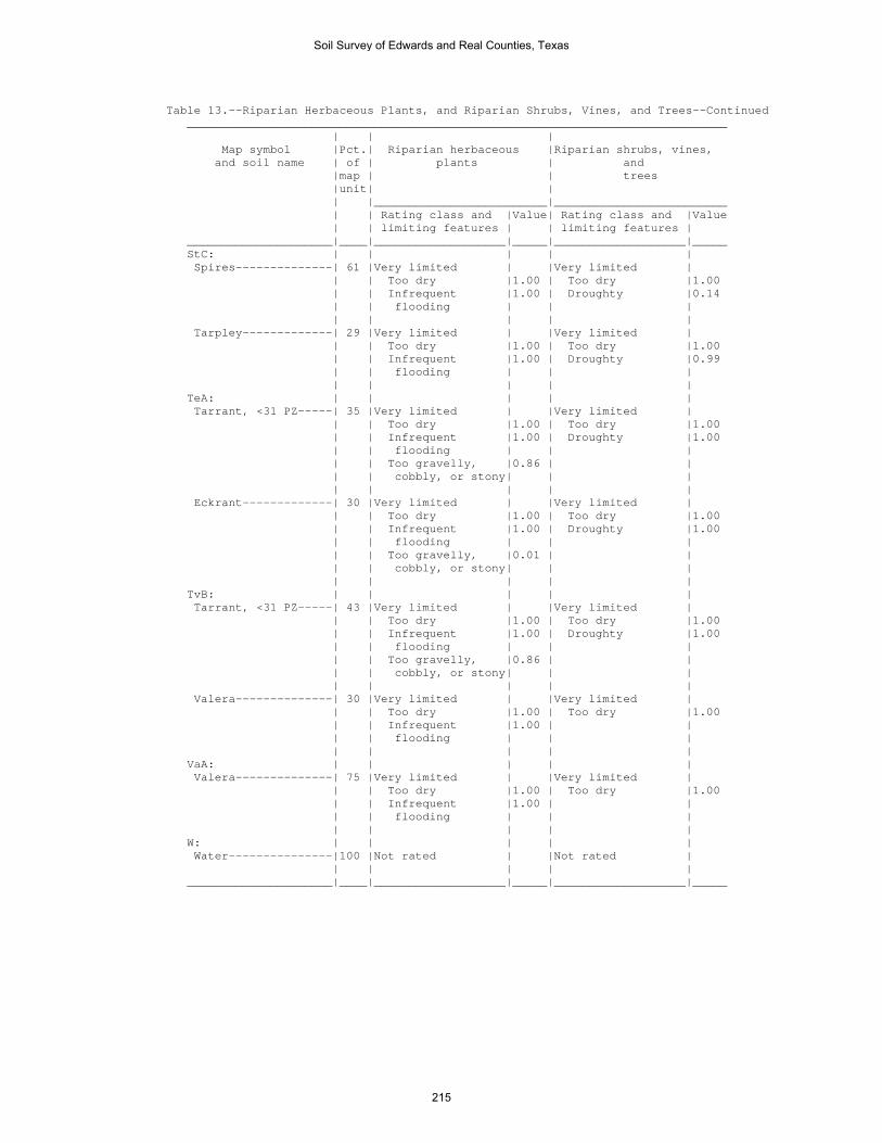
Table 13.--Riparian Herbaceous Plants, and Riparian Shrubs, Vines, and Trees--Continued ______________________________________________________________________________ | | | Map symbol |Pct.| Riparian herbaceous |Riparian shrubs, vines, and soil name | of | plants | and |map | | trees |unit| | | |_________________________|_________________________ | | Rating class and |Value| Rating class and |Value | | limiting features | | limiting features | _____________________|____|___________________|_____|___________________|_____ StC: | | | | | Spires--------------| 61 |Very limited | |Very limited | | | Too dry |1.00 | Too dry |1.00 | | Infrequent |1.00 | Droughty |0.14 | | flooding | | | | | | | | Tarpley-------------| 29 |Very limited | |Very limited | | | Too dry |1.00 | Too dry |1.00 | | Infrequent |1.00 | Droughty |0.99 | | flooding | | | | | | | | TeA: | | | | | Tarrant, <31 PZ-----| 35 |Very limited | |Very limited | | | Too dry |1.00 | Too dry |1.00 | | Infrequent |1.00 | Droughty |1.00 | | flooding | | | | | Too gravelly, |0.86 | | | | cobbly, or stony| | | | | | | | Eckrant-------------| 30 |Very limited | |Very limited | | | Too dry |1.00 | Too dry |1.00 | | Infrequent |1.00 | Droughty |1.00 | | flooding | | | | | Too gravelly, |0.01 | | | | cobbly, or stony| | | | | | | | TvB: | | | | | Tarrant, <31 PZ-----| 43 |Very limited | |Very limited | | | Too dry |1.00 | Too dry |1.00 | | Infrequent |1.00 | Droughty |1.00 | | flooding | | | | | Too gravelly, |0.86 | | | | cobbly, or stony| | | | | | | | Valera--------------| 30 |Very limited | |Very limited | | | Too dry |1.00 | Too dry |1.00 | | Infrequent |1.00 | | | | flooding | | | | | | | | VaA: | | | | | Valera--------------| 75 |Very limited | |Very limited | | | Too dry |1.00 | Too dry |1.00 | | Infrequent |1.00 | | | | flooding | | | | | | | | W: | | | | | Water---------------|100 |Not rated | |Not rated | | | | | | _____________________|____|___________________|_____|___________________|_____
Soil Survey of Edwards and Real Counties, Texas
215

Table 14.--Camp Areas, Picnic Areas, and Playgrounds (The information in this table indicates the dominant soil condition but does not eliminate the need for onsite investigation. The numbers in the value columns range from 0.01 to 1.00. The larger the value, the greater the limitation. See text for further explanation of ratings in this table.) ________________________________________________________________________________________________________ | | | | Map symbol |Pct.| Camp areas | Picnic areas | Playgrounds and soil name | of | | | |map | | | |unit| | | | |_________________________|_________________________|_________________________ | | Rating class and |Value| Rating class and |Value| Rating class and |Value | | limiting features | | limiting features | | limiting features | _____________________|____|___________________|_____|___________________|_____|___________________|_____ CkB: | | | | | | | Campwood------------| 53 |Somewhat limited | |Somewhat limited | |Somewhat limited | | | Too clayey |0.50 | Too clayey |0.50 | Too clayey |0.50 | | Slow water |0.39 | Slow water |0.39 | Slow water |0.39 | | movement | | movement | | movement | | | | | | | | Knippa, >27 PZ------| 30 |Somewhat limited | |Somewhat limited | |Somewhat limited | | | Too clayey |0.50 | Too clayey |0.50 | Too clayey |0.50 | | | | | | | CoB: | | | | | | | Cho-----------------| 33 |Very limited | |Very limited | |Very limited | | | Depth to cemented|1.00 | Depth to cemented|1.00 | Depth to cemented|1.00 | | pan | | pan | | pan | | | Gravel |0.14 | Gravel |0.14 | Gravel |1.00 | | | | | | | Angelo--------------| 29 |Not limited | |Not limited | |Not limited | | | | | | | | DeB: | | | | | | | Dev-----------------| 60 |Very limited | |Somewhat limited | |Very limited | | | Flooding |1.00 | Gravel |0.50 | Flooding |1.00 | | Gravel |0.50 | Flooding |0.40 | Gravel |1.00 | | | | | | | Riverwash-----------| 25 |Very limited | |Very limited | |Very limited | | | Flooding |1.00 | Gravel |1.00 | Gravel |1.00 | | Gravel |1.00 | Flooding |0.40 | Flooding |1.00 | | Large stones |0.01 | Large stones |0.01 | Large stones |0.01 | | content | | content | | content | | | | | | | | DnD: | | | | | | | Dina----------------| 60 |Somewhat limited | |Somewhat limited | |Very limited | | | Gravel |0.01 | Gravel |0.01 | Gravel |1.00 | | | | | | Depth to bedrock |0.29 | | | | | | Slope |0.12 | | | | | | | Eckrant-------------| 30 |Very limited | |Very limited | |Very limited | | | Depth to bedrock |1.00 | Depth to bedrock |1.00 | Depth to bedrock |1.00 | | Large stones |0.32 | Large stones |0.32 | Slope |0.88 | | content | | content | | | | | | | | | Large stones |0.32 | | | | | | content | | | | | | | Gravel |0.23 | | | | | | | EcF: | | | | | | | Eckrant-------------| 67 |Very limited | |Very limited | |Very limited | | | Depth to bedrock |1.00 | Depth to bedrock |1.00 | Slope |1.00 | | Slope |0.37 | Slope |0.37 | Depth to bedrock |1.00 | | Large stones |0.32 | Large stones |0.32 | Large stones |0.32 | | content | | content | | content | | | | | | | Gravel |0.23 | | | | | | | Rock outcrop--------| 13 |Not rated | |Not rated | |Not rated | | | | | | | |
Soil Survey of Edwards and Real Counties, Texas
216

Table 14.--Camp Areas, Picnic Areas, and Playgrounds--Continued ________________________________________________________________________________________________________ | | | | Map symbol |Pct.| Camp areas | Picnic areas | Playgrounds and soil name | of | | | |map | | | |unit| | | | |_________________________|_________________________|_________________________ | | Rating class and |Value| Rating class and |Value| Rating class and |Value | | limiting features | | limiting features | | limiting features | _____________________|____|___________________|_____|___________________|_____|___________________|_____ EcG: | | | | | | | Eckrant-------------| 50 |Very limited | |Very limited | |Very limited | | | Too steep |1.00 | Too steep |1.00 | Slope |1.00 | | Depth to bedrock |1.00 | Depth to bedrock |1.00 | Depth to bedrock |1.00 | | Large stones |0.32 | Large stones |0.32 | Large stones |0.32 | | content | | content | | content | | | | | | | Gravel |0.23 | | | | | | | Rock outcrop--------| 33 |Not rated | |Not rated | |Not rated | | | | | | | | ErB: | | | | | | | Ector---------------| 90 |Very limited | |Very limited | |Very limited | | | Depth to bedrock |1.00 | Depth to bedrock |1.00 | Gravel |1.00 | | Gravel |0.55 | Gravel |0.55 | Depth to bedrock |1.00 | | | | | | | ErF: | | | | | | | Ector---------------| 71 |Very limited | |Very limited | |Very limited | | | Depth to bedrock |1.00 | Depth to bedrock |1.00 | Slope |1.00 | | Large stones |0.61 | Large stones |0.61 | Depth to bedrock |1.00 | | content | | content | | | | | Slope |0.37 | Slope |0.37 | Gravel |0.94 | | | | | | Large stones |0.61 | | | | | | content | | | | | | | | Rock outcrop--------| 16 |Not rated | |Not rated | |Not rated | | | | | | | | ErG: | | | | | | | Ector---------------| 61 |Very limited | |Very limited | |Very limited | | | Too steep |1.00 | Too steep |1.00 | Slope |1.00 | | Depth to bedrock |1.00 | Depth to bedrock |1.00 | Depth to bedrock |1.00 | | Large stones |0.61 | Large stones |0.61 | Gravel |0.94 | | content | | content | | | | | | | | | Large stones |0.61 | | | | | | content | | | | | | | | Rock outcrop--------| 35 |Not rated | |Not rated | |Not rated | | | | | | | | IrA: | | | | | | | Irion---------------| 90 |Very limited | |Very limited | |Very limited | | | Ponding |1.00 | Ponding |1.00 | Ponding |1.00 | | Too clayey |0.50 | Too clayey |0.50 | Too clayey |0.50 | | Slow water |0.45 | Slow water |0.45 | Slow water |0.45 | | movement | | movement | | movement | | | | | | | | KrD: | | | | | | | Kerrville-----------| 54 |Not limited | |Not limited | |Somewhat limited | | | | | | | Slope |0.88 | | | | | | Gravel |0.37 | | | | | | Depth to bedrock |0.20 | | | | | | | Real----------------| 26 |Very limited | |Very limited | |Very limited | | | Gravel |1.00 | Gravel |1.00 | Gravel |1.00 | | Depth to bedrock |1.00 | Depth to bedrock |1.00 | Depth to bedrock |1.00 | | | | | | Slope |0.88 | | | | | | |
Soil Survey of Edwards and Real Counties, Texas
217
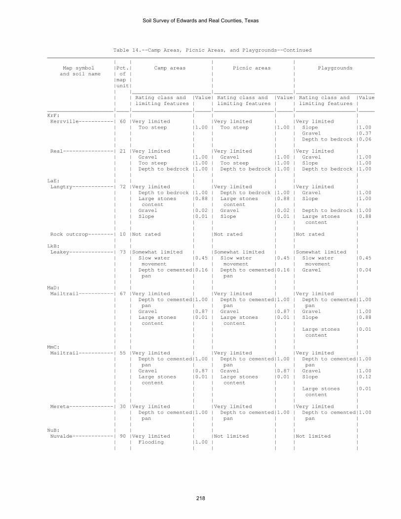
Table 14.--Camp Areas, Picnic Areas, and Playgrounds--Continued ________________________________________________________________________________________________________ | | | | Map symbol |Pct.| Camp areas | Picnic areas | Playgrounds and soil name | of | | | |map | | | |unit| | | | |_________________________|_________________________|_________________________ | | Rating class and |Value| Rating class and |Value| Rating class and |Value | | limiting features | | limiting features | | limiting features | _____________________|____|___________________|_____|___________________|_____|___________________|_____ KrF: | | | | | | | Kerrville-----------| 60 |Very limited | |Very limited | |Very limited | | | Too steep |1.00 | Too steep |1.00 | Slope |1.00 | | | | | | Gravel |0.37 | | | | | | Depth to bedrock |0.06 | | | | | | | Real----------------| 21 |Very limited | |Very limited | |Very limited | | | Gravel |1.00 | Gravel |1.00 | Gravel |1.00 | | Too steep |1.00 | Too steep |1.00 | Slope |1.00 | | Depth to bedrock |1.00 | Depth to bedrock |1.00 | Depth to bedrock |1.00 | | | | | | | LaE: | | | | | | | Langtry-------------| 72 |Very limited | |Very limited | |Very limited | | | Depth to bedrock |1.00 | Depth to bedrock |1.00 | Gravel |1.00 | | Large stones |0.88 | Large stones |0.88 | Slope |1.00 | | content | | content | | | | | Gravel |0.02 | Gravel |0.02 | Depth to bedrock |1.00 | | Slope |0.01 | Slope |0.01 | Large stones |0.88 | | | | | | content | | | | | | | | Rock outcrop--------| 10 |Not rated | |Not rated | |Not rated | | | | | | | | LkB: | | | | | | | Leakey--------------| 73 |Somewhat limited | |Somewhat limited | |Somewhat limited | | | Slow water |0.45 | Slow water |0.45 | Slow water |0.45 | | movement | | movement | | movement | | | Depth to cemented|0.16 | Depth to cemented|0.16 | Gravel |0.04 | | pan | | pan | | | | | | | | | | MaD: | | | | | | | Mailtrail-----------| 67 |Very limited | |Very limited | |Very limited | | | Depth to cemented|1.00 | Depth to cemented|1.00 | Depth to cemented|1.00 | | pan | | pan | | pan | | | Gravel |0.87 | Gravel |0.87 | Gravel |1.00 | | Large stones |0.01 | Large stones |0.01 | Slope |0.88 | | content | | content | | | | | | | | | Large stones |0.01 | | | | | | content | | | | | | | | MmC: | | | | | | | Mailtrail-----------| 55 |Very limited | |Very limited | |Very limited | | | Depth to cemented|1.00 | Depth to cemented|1.00 | Depth to cemented|1.00 | | pan | | pan | | pan | | | Gravel |0.87 | Gravel |0.87 | Gravel |1.00 | | Large stones |0.01 | Large stones |0.01 | Slope |0.12 | | content | | content | | | | | | | | | Large stones |0.01 | | | | | | content | | | | | | | | Mereta--------------| 30 |Very limited | |Very limited | |Very limited | | | Depth to cemented|1.00 | Depth to cemented|1.00 | Depth to cemented|1.00 | | pan | | pan | | pan | | | | | | | | NuB: | | | | | | | Nuvalde-------------| 90 |Very limited | |Not limited | |Not limited | | | Flooding |1.00 | | | | | | | | | | |
Soil Survey of Edwards and Real Counties, Texas
218

Table 14.--Camp Areas, Picnic Areas, and Playgrounds--Continued ________________________________________________________________________________________________________ | | | | Map symbol |Pct.| Camp areas | Picnic areas | Playgrounds and soil name | of | | | |map | | | |unit| | | | |_________________________|_________________________|_________________________ | | Rating class and |Value| Rating class and |Value| Rating class and |Value | | limiting features | | limiting features | | limiting features | _____________________|____|___________________|_____|___________________|_____|___________________|_____ OdA: | | | | | | | Oakalla, >27 PZ-----| 50 |Very limited | |Not limited | |Somewhat limited | | | Flooding |1.00 | | | Flooding |0.60 | | | | | | | Dev-----------------| 40 |Very limited | |Somewhat limited | |Very limited | | | Flooding |1.00 | Gravel |0.50 | Flooding |1.00 | | Gravel |0.50 | Flooding |0.40 | Gravel |1.00 | | | | | | | OrA: | | | | | | | Orif----------------| 95 |Very limited | |Somewhat limited | |Very limited | | | Flooding |1.00 | Flooding |0.40 | Flooding |1.00 | | | | | | Gravel |0.11 OrG: | | | | | | | Oplin---------------| 53 |Very limited | |Very limited | |Very limited | | | Too steep |1.00 | Too steep |1.00 | Slope |1.00 | | Depth to bedrock |1.00 | Depth to bedrock |1.00 | Depth to bedrock |1.00 | | Large stones |0.12 | Large stones |0.12 | Gravel |1.00 | | content | | content | | | | | Gravel |0.04 | Gravel |0.04 | Large stones |0.12 | | | | | | content | | | | | | | | Rock outcrop--------| 30 |Not rated | |Not rated | |Not rated | | | | | | | | PeB: | | | | | | | Prade---------------| 35 |Very limited | |Very limited | |Very limited | | | Depth to cemented|1.00 | Depth to cemented|1.00 | Depth to cemented|1.00 | | pan | | pan | | pan | | | Depth to bedrock |1.00 | Depth to bedrock |1.00 | Depth to bedrock |1.00 | | Too clayey |0.50 | Too clayey |0.50 | Too clayey |0.50 | | Large stones |0.42 | Large stones |0.42 | Large stones |0.42 | | content | | content | | content | | | | | | | Gravel |0.08 | | | | | | | Eckrant-------------| 28 |Very limited | |Very limited | |Very limited | | | Depth to bedrock |1.00 | Depth to bedrock |1.00 | Depth to bedrock |1.00 | | Large stones |0.32 | Large stones |0.32 | Large stones |0.32 | | content | | content | | content | | | | | | | Gravel |0.23 PIT: | | | | | | | Pits----------------|100 |Not rated | |Not rated | |Not rated | | | | | | | | PrC: | | | | | | | Prade---------------| 43 |Very limited | |Very limited | |Very limited | | | Depth to cemented|1.00 | Depth to cemented|1.00 | Depth to cemented|1.00 | | pan | | pan | | pan | | | Depth to bedrock |1.00 | Depth to bedrock |1.00 | Depth to bedrock |1.00 | | Too clayey |0.50 | Too clayey |0.50 | Slope |0.50 | | Large stones |0.42 | Large stones |0.42 | Too clayey |0.50 | | content | | content | | | | | | | | | Large stones |0.42 | | | | | | content | | | | | | | | Tarrant, <31 PZ-----| 40 |Very limited | |Very limited | |Very limited | | | Depth to bedrock |1.00 | Depth to bedrock |1.00 | Depth to bedrock |1.00 | | Large stones |0.77 | Large stones |0.77 | Large stones |0.77 | | content | | content | | content | | | Too clayey |0.50 | Too clayey |0.50 | Slope |0.50 | | | | | | Too clayey |0.50 | | | | | | Gravel |0.01 | | | | | | |
Soil Survey of Edwards and Real Counties, Texas
219

Table 14.--Camp Areas, Picnic Areas, and Playgrounds--Continued ________________________________________________________________________________________________________ | | | | Map symbol |Pct.| Camp areas | Picnic areas | Playgrounds and soil name | of | | | |map | | | |unit| | | | |_________________________|_________________________|_________________________ | | Rating class and |Value| Rating class and |Value| Rating class and |Value | | limiting features | | limiting features | | limiting features | _____________________|____|___________________|_____|___________________|_____|___________________|_____ PtB: | | | | | | | Pratley-------------| 75 |Somewhat limited | |Somewhat limited | |Not limited | | | Depth to cemented|0.90 | Depth to cemented|0.90 | | | | pan | | pan | | | | | | | | | | RaF: | | | | | | | Real----------------| 53 |Very limited | |Very limited | |Very limited | | | Gravel |1.00 | Gravel |1.00 | Gravel |1.00 | | Depth to bedrock |1.00 | Depth to bedrock |1.00 | Slope |1.00 | | Slope |0.37 | Slope |0.37 | Depth to bedrock |1.00 | | | | | | | Oplin---------------| 24 |Very limited | |Very limited | |Very limited | | | Depth to bedrock |1.00 | Depth to bedrock |1.00 | Gravel |1.00 | | Large stones |0.12 | Large stones |0.12 | Slope |1.00 | | content | | content | | | | | Gravel |0.04 | Gravel |0.04 | Depth to bedrock |1.00 | | | | | | Large stones |0.12 | | | | | | content | | | | | | | | RdB: | | | | | | | Rio Diablo----------| 85 |Very limited | |Somewhat limited | |Somewhat limited | | | Flooding |1.00 | Too clayey |0.50 | Too clayey |0.50 | | Too clayey |0.50 | | | | | | | | | | | RfB: | | | | | | | Rio Frio------------| 65 |Very limited | |Not limited | |Somewhat limited | | | Flooding |1.00 | | | Gravel |0.06 | | | | | | | Vanderpool----------| 20 |Very limited | |Not limited | |Somewhat limited | | | Flooding |1.00 | | | Gravel |0.06 | | | | | | | RsB: | | | | | | | Riverwash-----------| 75 |Very limited | |Very limited | |Very limited | | | Flooding |1.00 | Gravel |1.00 | Gravel |1.00 | | Gravel |1.00 | Flooding |0.40 | Flooding |1.00 | | Large stones |0.01 | Large stones |0.01 | Large stones |0.01 | | content | | content | | content | | | | | | | | Dev-----------------| 15 |Very limited | |Somewhat limited | |Very limited | | | Flooding |1.00 | Gravel |0.50 | Flooding |1.00 | | Gravel |0.50 | Flooding |0.40 | Gravel |1.00 | | | | | | | RtG: | | | | | | | Rock outcrop--------| 55 |Not rated | |Not rated | |Not rated | | | | | | | | Langtry-------------| 40 |Very limited | |Very limited | |Very limited | | | Too steep |1.00 | Too steep |1.00 | Slope |1.00 | | Depth to bedrock |1.00 | Depth to bedrock |1.00 | Depth to bedrock |1.00 | | Large stones |0.88 | Large stones |0.88 | Gravel |1.00 | | content | | content | | | | | Gravel |0.02 | Gravel |0.02 | Large stones |0.88 | | | | | | content | | | | | | | |
Soil Survey of Edwards and Real Counties, Texas
220

Table 14.--Camp Areas, Picnic Areas, and Playgrounds--Continued ________________________________________________________________________________________________________ | | | | Map symbol |Pct.| Camp areas | Picnic areas | Playgrounds and soil name | of | | | |map | | | |unit| | | | |_________________________|_________________________|_________________________ | | Rating class and |Value| Rating class and |Value| Rating class and |Value | | limiting features | | limiting features | | limiting features | _____________________|____|___________________|_____|___________________|_____|___________________|_____ StC: | | | | | | | Spires--------------| 61 |Somewhat limited | |Somewhat limited | |Somewhat limited | | | Slow water |0.39 | Slow water |0.39 | Depth to bedrock |0.65 | | movement | | movement | | | | | | | | | Slow water |0.39 | | | | | | movement | | | | | | | Gravel |0.17 | | | | | | Slope |0.12 | | | | | | | Tarpley-------------| 29 |Very limited | |Very limited | |Very limited | | | Depth to bedrock |1.00 | Depth to bedrock |1.00 | Depth to bedrock |1.00 | | Slow water |0.39 | Slow water |0.39 | Slow water |0.39 | | movement | | movement | | movement | | | | | | | Slope |0.12 | | | | | | | TeA: | | | | | | | Tarrant, <31 PZ-----| 35 |Very limited | |Very limited | |Very limited | | | Depth to bedrock |1.00 | Depth to bedrock |1.00 | Depth to bedrock |1.00 | | Large stones |0.77 | Large stones |0.77 | Large stones |0.77 | | content | | content | | content | | | Too clayey |0.50 | Too clayey |0.50 | Too clayey |0.50 | | | | | | Gravel |0.01 | | | | | | | Eckrant-------------| 30 |Very limited | |Very limited | |Very limited | | | Depth to bedrock |1.00 | Depth to bedrock |1.00 | Depth to bedrock |1.00 | | Too clayey |0.50 | Too clayey |0.50 | Too clayey |0.50 | | Large stones |0.26 | Large stones |0.26 | Large stones |0.26 | | content | | content | | content | | | | | | | | TvB: | | | | | | | Tarrant, <31 PZ-----| 43 |Very limited | |Very limited | |Very limited | | | Depth to bedrock |1.00 | Depth to bedrock |1.00 | Depth to bedrock |1.00 | | Large stones |0.77 | Large stones |0.77 | Large stones |0.77 | | content | | content | | content | | | Too clayey |0.50 | Too clayey |0.50 | Too clayey |0.50 | | | | | | Gravel |0.01 | | | | | | | Valera--------------| 30 |Somewhat limited | |Somewhat limited | |Somewhat limited | | | Too clayey |0.50 | Too clayey |0.50 | Too clayey |0.50 | | Depth to cemented|0.46 | Depth to cemented|0.46 | Gravel |0.05 | | pan | | pan | | | | | | | | | | VaA: | | | | | | | Valera--------------| 75 |Somewhat limited | |Somewhat limited | |Somewhat limited | | | Too clayey |0.50 | Too clayey |0.50 | Too clayey |0.50 | | Depth to cemented|0.29 | Depth to cemented|0.29 | Gravel |0.05 | | pan | | pan | | | | | | | | | | W: | | | | | | | Water---------------|100 |Not rated | |Not rated | |Not rated | | | | | | | | _____________________|____|___________________|_____|___________________|_____|___________________|_____
Soil Survey of Edwards and Real Counties, Texas
221

Table 15.--Paths, Trails, and Golf Course Fairways (The information in this table indicates the dominant soil condition but does not eliminate the need for onsite investigation. The numbers in the value columns range from 0.01 to 1.00. The larger the value, the greater the limitation. See text for further explanation of ratings in this table.) ________________________________________________________________________________________________________ | | | | Map symbol |Pct.| Paths and trails | Off-road | Golf course fairways and soil name | of | | motorcycle trails | |map | | | |unit| | | | |_________________________|_________________________|_________________________ | | Rating class and |Value| Rating class and |Value| Rating class and |Value | | limiting features | | limiting features | | limiting features | _____________________|____|___________________|_____|___________________|_____|___________________|_____ CkB: | | | | | | | Campwood------------| 53 |Somewhat limited | |Somewhat limited | |Very limited | | | Too clayey |0.50 | Too clayey |0.50 | Too clayey |1.00 | | | | | | | Knippa, >27 PZ------| 30 |Somewhat limited | |Somewhat limited | |Very limited | | | Too clayey |0.50 | Too clayey |0.50 | Too clayey |1.00 | | | | | | Carbonate content|1.00 | | | | | | | CoB: | | | | | | | Cho-----------------| 33 |Not limited | |Not limited | |Very limited | | | | | | | Depth to cemented|1.00 | | | | | | pan | | | | | | | Droughty |1.00 | | | | | | Carbonate content|1.00 | | | | | | Gravel |0.14 | | | | | | | Angelo--------------| 29 |Not limited | |Not limited | |Not limited | | | | | | | | DeB: | | | | | | | Dev-----------------| 60 |Somewhat limited | |Somewhat limited | |Very limited | | | Flooding |0.40 | Flooding |0.40 | Flooding |1.00 | | | | | | Carbonate content|1.00 | | | | | | Large stones |0.74 | | | | | | Gravel |0.50 | | | | | | Droughty |0.16 | | | | | | | Riverwash-----------| 25 |Very limited | |Very limited | |Very limited | | | Gravel |1.00 | Gravel |1.00 | Flooding |1.00 | | Flooding |0.40 | Flooding |0.40 | Droughty |1.00 | | Large stones |0.01 | Large stones |0.01 | Gravel |1.00 | | content | | content | | | | | | | | | Large stones |0.99 | | | | | | | DnD: | | | | | | | Dina----------------| 60 |Not limited | |Not limited | |Very limited | | | | | | | Droughty |1.00 | | | | | | Large stones |0.84 | | | | | | Depth to bedrock |0.29 | | | | | | Gravel |0.01 | | | | | | | Eckrant-------------| 30 |Somewhat limited | |Somewhat limited | |Very limited | | | Large stones |0.32 | Large stones |0.32 | Droughty |1.00 | | content | | content | | | | | | | | | Depth to bedrock |1.00 | | | | | | Large stones |1.00 EcF: | | | | | | | Eckrant-------------| 67 |Somewhat limited | |Somewhat limited | |Very limited | | | Large stones |0.32 | Large stones |0.32 | Droughty |1.00 | | content | | content | | | | | | | | | Depth to bedrock |1.00 | | | | | | Large stones |1.00 | | | | | | Slope |0.37 | | | | | | | Rock outcrop--------| 13 |Not rated | |Not rated | |Not rated | | | | | | | |
Soil Survey of Edwards and Real Counties, Texas
222

Table 15.--Paths, Trails, and Golf Course Fairways--Continued ________________________________________________________________________________________________________ | | | | Map symbol |Pct.| Paths and trails | Off-road | Golf course fairways and soil name | of | | motorcycle trails | |map | | | |unit| | | | |_________________________|_________________________|_________________________ | | Rating class and |Value| Rating class and |Value| Rating class and |Value | | limiting features | | limiting features | | limiting features | _____________________|____|___________________|_____|___________________|_____|___________________|_____ EcG: | | | | | | | Eckrant-------------| 50 |Very limited | |Very limited | |Very limited | | | Slope |1.00 | Slope |1.00 | Too steep |1.00 | | Large stones |0.32 | Large stones |0.32 | Droughty |1.00 | | content | | content | | | | | | | | | Depth to bedrock |1.00 | | | | | | Large stones |1.00 | | | | | | | Rock outcrop--------| 33 |Not rated | |Not rated | |Not rated | | | | | | | | ErB: | | | | | | | Ector---------------| 90 |Not limited | |Not limited | |Very limited | | | | | | | Droughty |1.00 | | | | | | Depth to bedrock |1.00 | | | | | | Carbonate content|1.00 | | | | | | Gravel |0.55 | | | | | | Large stones |0.08 | | | | | | | ErF: | | | | | | | Ector---------------| 71 |Somewhat limited | |Somewhat limited | |Very limited | | | Large stones |0.61 | Large stones |0.61 | Droughty |1.00 | | content | | content | | | | | | | | | Depth to bedrock |1.00 | | | | | | Large stones |1.00 | | | | | | Carbonate content|1.00 | | | | | | Slope |0.37 | | | | | | | Rock outcrop--------| 16 |Not rated | |Not rated | |Not rated | | | | | | | | ErG: | | | | | | | Ector---------------| 61 |Very limited | |Somewhat limited | |Very limited | | | Slope |1.00 | Large stones |0.61 | Too steep |1.00 | | | | content | | | | | Large stones |0.61 | Slope |0.22 | Droughty |1.00 | | content | | | | | | | | | | | Depth to bedrock |1.00 | | | | | | Large stones |1.00 | | | | | | Carbonate content|1.00 | | | | | | | Rock outcrop--------| 35 |Not rated | |Not rated | |Not rated | | | | | | | | IrA: | | | | | | | Irion---------------| 90 |Very limited | |Very limited | |Very limited | | | Ponding |1.00 | Ponding |1.00 | Ponding |1.00 | | Too clayey |0.50 | Too clayey |0.50 | Too clayey |1.00 | | | | | | |
Soil Survey of Edwards and Real Counties, Texas
223

Table 15.--Paths, Trails, and Golf Course Fairways--Continued ________________________________________________________________________________________________________ | | | | Map symbol |Pct.| Paths and trails | Off-road | Golf course fairways and soil name | of | | motorcycle trails | |map | | | |unit| | | | |_________________________|_________________________|_________________________ | | Rating class and |Value| Rating class and |Value| Rating class and |Value | | limiting features | | limiting features | | limiting features | _____________________|____|___________________|_____|___________________|_____|___________________|_____ KrD: | | | | | | | Kerrville-----------| 54 |Not limited | |Not limited | |Very limited | | | | | | | Carbonate content|1.00 | | | | | | Droughty |0.93 | | | | | | Depth to bedrock |0.20 | | | | | | Large stones |0.01 | | | | | | | Real----------------| 26 |Not limited | |Not limited | |Very limited | | | | | | | Droughty |1.00 | | | | | | Depth to bedrock |1.00 | | | | | | Gravel |1.00 | | | | | | Carbonate content|1.00 | | | | | | Large stones |0.08 | | | | | | | KrF: | | | | | | | Kerrville-----------| 60 |Somewhat limited | |Not limited | |Very limited | | | Slope |0.98 | | | Too steep |1.00 | | | | | | Carbonate content|1.00 | | | | | | Droughty |0.13 | | | | | | Depth to bedrock |0.06 | | | | | | Large stones |0.01 | | | | | | | Real----------------| 21 |Somewhat limited | |Not limited | |Very limited | | | Slope |0.98 | | | Droughty |1.00 | | | | | | Depth to bedrock |1.00 | | | | | | Gravel |1.00 | | | | | | Too steep |1.00 | | | | | | Carbonate content|1.00 | | | | | | | LaE: | | | | | | | Langtry-------------| 72 |Somewhat limited | |Somewhat limited | |Very limited | | | Large stones |0.88 | Large stones |0.88 | Large stones |1.00 | | content | | content | | | | | | | | | Droughty |1.00 | | | | | | Depth to bedrock |1.00 | | | | | | Carbonate content|1.00 | | | | | | Gravel |0.02 | | | | | | | Rock outcrop--------| 10 |Not rated | |Not rated | |Not rated | | | | | | | | LkB: | | | | | | | Leakey--------------| 73 |Not limited | |Not limited | |Very limited | | | | | | | Carbonate content|1.00 | | | | | | Depth to cemented|0.15 | | | | | | pan | | | | | | | Droughty |0.03 | | | | | | | MaD: | | | | | | | Mailtrail-----------| 67 |Somewhat limited | |Somewhat limited | |Very limited | | | Large stones |0.01 | Large stones |0.01 | Depth to cemented|1.00 | | content | | content | | pan | | | | | | | Droughty |1.00 | | | | | | Carbonate content|1.00 | | | | | | Large stones |0.97 | | | | | | Gravel |0.87 | | | | | | |
Soil Survey of Edwards and Real Counties, Texas
224

Table 15.--Paths, Trails, and Golf Course Fairways--Continued ________________________________________________________________________________________________________ | | | | Map symbol |Pct.| Paths and trails | Off-road | Golf course fairways and soil name | of | | motorcycle trails | |map | | | |unit| | | | |_________________________|_________________________|_________________________ | | Rating class and |Value| Rating class and |Value| Rating class and |Value | | limiting features | | limiting features | | limiting features | _____________________|____|___________________|_____|___________________|_____|___________________|_____ MmC: | | | | | | | Mailtrail-----------| 55 |Somewhat limited | |Somewhat limited | |Very limited | | | Large stones |0.01 | Large stones |0.01 | Depth to cemented|1.00 | | content | | content | | pan | | | | | | | Droughty |1.00 | | | | | | Carbonate content|1.00 | | | | | | Large stones |0.97 | | | | | | Gravel |0.87 | | | | | | | Mereta--------------| 30 |Not limited | |Not limited | |Very limited | | | | | | | Depth to cemented|1.00 | | | | | | pan | | | | | | | Droughty |0.16 | | | | | | | NuB: | | | | | | | Nuvalde-------------| 90 |Not limited | |Not limited | |Very limited | | | | | | | Carbonate content|1.00 | | | | | | | OdA: | | | | | | | Oakalla, >27 PZ-----| 50 |Not limited | |Not limited | |Very limited | | | | | | | Carbonate content|1.00 | | | | | | Flooding |0.60 | | | | | | | Dev-----------------| 40 |Somewhat limited | |Somewhat limited | |Very limited | | | Flooding |0.40 | Flooding |0.40 | Flooding |1.00 | | | | | | Carbonate content|1.00 | | | | | | Large stones |0.74 | | | | | | Gravel |0.50 | | | | | | Droughty |0.16 | | | | | | | OrA: | | | | | | | Orif----------------| 95 |Somewhat limited | |Somewhat limited | |Very limited | | | Flooding |0.40 | Flooding |0.40 | Flooding |1.00 | | | | | | Carbonate content|1.00 | | | | | | Droughty |0.63 | | | | | | Large stones |0.08 | | | | | | | OrG: | | | | | | | Oplin---------------| 53 |Very limited | |Somewhat limited | |Very limited | | | Slope |1.00 | Slope |0.22 | Too steep |1.00 | | Large stones |0.12 | Large stones |0.12 | Droughty |1.00 | | content | | content | | | | | | | | | Depth to bedrock |1.00 | | | | | | Large stones |1.00 | | | | | | Gravel |0.04 | | | | | | | Rock outcrop--------| 30 |Not rated | |Not rated | |Not rated | | | | | | | |
Soil Survey of Edwards and Real Counties, Texas
225

Table 15.--Paths, Trails, and Golf Course Fairways--Continued ________________________________________________________________________________________________________ | | | | Map symbol |Pct.| Paths and trails | Off-road | Golf course fairways and soil name | of | | motorcycle trails | |map | | | |unit| | | | |_________________________|_________________________|_________________________ | | Rating class and |Value| Rating class and |Value| Rating class and |Value | | limiting features | | limiting features | | limiting features | _____________________|____|___________________|_____|___________________|_____|___________________|_____ PeB: | | | | | | | Prade---------------| 35 |Somewhat limited | |Somewhat limited | |Very limited | | | Too clayey |0.50 | Too clayey |0.50 | Depth to cemented|1.00 | | | | | | pan | | | Large stones |0.42 | Large stones |0.42 | Droughty |1.00 | | content | | content | | | | | | | | | Large stones |1.00 | | | | | | Depth to bedrock |1.00 | | | | | | Too clayey |1.00 | | | | | | | Eckrant-------------| 28 |Somewhat limited | |Somewhat limited | |Very limited | | | Large stones |0.32 | Large stones |0.32 | Droughty |1.00 | | content | | content | | | | | | | | | Depth to bedrock |1.00 | | | | | | Large stones |1.00 | | | | | | | PIT: | | | | | | | Pits----------------|100 |Not rated | |Not rated | |Not rated | | | | | | | | PrC: | | | | | | | Prade---------------| 43 |Somewhat limited | |Somewhat limited | |Very limited | | | Too clayey |0.50 | Too clayey |0.50 | Depth to cemented|1.00 | | | | | | pan | | | Large stones |0.42 | Large stones |0.42 | Droughty |1.00 | | content | | content | | | | | | | | | Large stones |1.00 | | | | | | Depth to bedrock |1.00 | | | | | | Too clayey |1.00 | | | | | | | Tarrant, <31 PZ-----| 40 |Somewhat limited | |Somewhat limited | |Very limited | | | Large stones |0.77 | Large stones |0.77 | Large stones |1.00 | | content | | content | | | | | Too clayey |0.50 | Too clayey |0.50 | Droughty |1.00 | | | | | | Depth to bedrock |1.00 | | | | | | Too clayey |1.00 | | | | | | | PtB: | | | | | | | Pratley-------------| 75 |Not limited | |Not limited | |Somewhat limited | | | | | | | Depth to cemented|0.90 | | | | | | pan | | | | | | | Depth to bedrock |0.46 | | | | | | Droughty |0.01 | | | | | | Large stones |0.01 | | | | | | | RaF: | | | | | | | Real----------------| 53 |Not limited | |Not limited | |Very limited | | | | | | | Droughty |1.00 | | | | | | Depth to bedrock |1.00 | | | | | | Gravel |1.00 | | | | | | Carbonate content|1.00 | | | | | | Slope |0.37 | | | | | | | Oplin---------------| 24 |Somewhat limited | |Somewhat limited | |Very limited | | | Large stones |0.12 | Large stones |0.12 | Droughty |1.00 | | content | | content | | | | | | | | | Depth to bedrock |1.00 | | | | | | Large stones |1.00 | | | | | | Gravel |0.04 | | | | | | |
Soil Survey of Edwards and Real Counties, Texas
226

Table 15.--Paths, Trails, and Golf Course Fairways--Continued ________________________________________________________________________________________________________ | | | | Map symbol |Pct.| Paths and trails | Off-road | Golf course fairways and soil name | of | | motorcycle trails | |map | | | |unit| | | | |_________________________|_________________________|_________________________ | | Rating class and |Value| Rating class and |Value| Rating class and |Value | | limiting features | | limiting features | | limiting features | _____________________|____|___________________|_____|___________________|_____|___________________|_____ RdB: | | | | | | | Rio Diablo----------| 85 |Somewhat limited | |Somewhat limited | |Very limited | | | Too clayey |0.50 | Too clayey |0.50 | Too clayey |1.00 | | | | | | | RfB: | | | | | | | Rio Frio------------| 65 |Not limited | |Not limited | |Very limited | | | | | | | Carbonate content|1.00 | | | | | | | Vanderpool----------| 20 |Not limited | |Not limited | |Very limited | | | | | | | Carbonate content|1.00 | | | | | | | RsB: | | | | | | | Riverwash-----------| 75 |Very limited | |Very limited | |Very limited | | | Gravel |1.00 | Gravel |1.00 | Flooding |1.00 | | Flooding |0.40 | Flooding |0.40 | Droughty |1.00 | | Large stones |0.01 | Large stones |0.01 | Gravel |1.00 | | content | | content | | | | | | | | | Large stones |0.99 | | | | | | | Dev-----------------| 15 |Somewhat limited | |Somewhat limited | |Very limited | | | Flooding |0.40 | Flooding |0.40 | Flooding |1.00 | | | | | | Carbonate content|1.00 | | | | | | Large stones |0.74 | | | | | | Gravel |0.50 | | | | | | Droughty |0.16 | | | | | | | RtG: | | | | | | | Rock outcrop--------| 55 |Not rated | |Not rated | |Not rated | | | | | | | | Langtry-------------| 40 |Very limited | |Somewhat limited | |Very limited | | | Slope |1.00 | Large stones |0.88 | Too steep |1.00 | | | | content | | | | | Large stones |0.88 | Slope |0.08 | Large stones |1.00 | | content | | | | | | | | | | | Droughty |1.00 | | | | | | Depth to bedrock |1.00 | | | | | | Carbonate content|1.00 | | | | | | | StC: | | | | | | | Spires--------------| 61 |Not limited | |Not limited | |Somewhat limited | | | | | | | Depth to bedrock |0.65 | | | | | | Droughty |0.16 | | | | | | Large stones |0.08 | | | | | | | Tarpley-------------| 29 |Not limited | |Not limited | |Very limited | | | | | | | Depth to bedrock |1.00 | | | | | | Droughty |0.99 | | | | | | Large stones |0.74 | | | | | | |
Soil Survey of Edwards and Real Counties, Texas
227

Table 15.--Paths, Trails, and Golf Course Fairways--Continued ________________________________________________________________________________________________________ | | | | Map symbol |Pct.| Paths and trails | Off-road | Golf course fairways and soil name | of | | motorcycle trails | |map | | | |unit| | | | |_________________________|_________________________|_________________________ | | Rating class and |Value| Rating class and |Value| Rating class and |Value | | limiting features | | limiting features | | limiting features | _____________________|____|___________________|_____|___________________|_____|___________________|_____ TeA: | | | | | | | Tarrant, <31 PZ-----| 35 |Somewhat limited | |Somewhat limited | |Very limited | | | Large stones |0.77 | Large stones |0.77 | Large stones |1.00 | | content | | content | | | | | Too clayey |0.50 | Too clayey |0.50 | Droughty |1.00 | | | | | | Depth to bedrock |1.00 | | | | | | Too clayey |1.00 | | | | | | | Eckrant-------------| 30 |Somewhat limited | |Somewhat limited | |Very limited | | | Too clayey |0.50 | Too clayey |0.50 | Droughty |1.00 | | Large stones |0.26 | Large stones |0.26 | Depth to bedrock |1.00 | | content | | content | | | | | | | | | Large stones |1.00 | | | | | | Too clayey |1.00 | | | | | | | TvB: | | | | | | | Tarrant, <31 PZ-----| 43 |Somewhat limited | |Somewhat limited | |Very limited | | | Large stones |0.77 | Large stones |0.77 | Large stones |1.00 | | content | | content | | | | | Too clayey |0.50 | Too clayey |0.50 | Droughty |1.00 | | | | | | Depth to bedrock |1.00 | | | | | | Too clayey |1.00 | | | | | | | Valera--------------| 30 |Somewhat limited | |Somewhat limited | |Very limited | | | Too clayey |0.50 | Too clayey |0.50 | Too clayey |1.00 | | | | | | Depth to cemented|0.46 | | | | | | pan | | | | | | | Depth to bedrock |0.29 | | | | | | | VaA: | | | | | | | Valera--------------| 75 |Somewhat limited | |Somewhat limited | |Very limited | | | Too clayey |0.50 | Too clayey |0.50 | Too clayey |1.00 | | | | | | Depth to cemented|0.29 | | | | | | pan | | | | | | | Depth to bedrock |0.10 | | | | | | | W: | | | | | | | Water---------------|100 |Not rated | |Not rated | |Not rated | | | | | | | | _____________________|____|___________________|_____|___________________|_____|___________________|_____
Soil Survey of Edwards and Real Counties, Texas
228

Table 16.--Dwellings and Small Commercial Buildings (The information in this table indicates the dominant soil condition but does not eliminate the need for onsite investigation. The numbers in the value columns range from 0.01 to 1.00. The larger the value, the greater the limitation. See text for further explanation of ratings in this table.) ________________________________________________________________________________________________________ | | | | Map symbol |Pct.| Dwellings without | Dwellings with | Small commercial and soil name | of | basements | basements | buildings |map | | | |unit| | | | |_________________________|_________________________|_________________________ | | Rating class and |Value| Rating class and |Value| Rating class and |Value | | limiting features | | limiting features | | limiting features | _____________________|____|___________________|_____|___________________|_____|___________________|_____ CkB: | | | | | | | Campwood------------| 53 |Very limited | |Very limited | |Very limited | | | Shrink-swell |1.00 | Shrink-swell |1.00 | Shrink-swell |1.00 | | | | | | | Knippa, >27 PZ------| 30 |Very limited | |Very limited | |Very limited | | | Shrink-swell |1.00 | Shrink-swell |1.00 | Shrink-swell |1.00 | | | | | | | CoB: | | | | | | | Cho-----------------| 33 |Somewhat limited | |Very limited | |Somewhat limited | | | Depth to thin |0.50 | Depth to thin |1.00 | Depth to thin |1.00 | | cemented pan | | cemented pan | | cemented pan | | | | | | | | Angelo--------------| 29 |Somewhat limited | |Somewhat limited | |Somewhat limited | | | Shrink-swell |0.50 | Shrink-swell |0.50 | Shrink-swell |0.50 | | | | Depth to hard |0.05 | | | | | | bedrock | | | | | | | | | | DeB: | | | | | | | Dev-----------------| 60 |Very limited | |Very limited | |Very limited | | | Flooding |1.00 | Flooding |1.00 | Flooding |1.00 | | | | | | | Riverwash-----------| 25 |Very limited | |Very limited | |Very limited | | | Flooding |1.00 | Flooding |1.00 | Flooding |1.00 | | Large stones |0.05 | Large stones |0.05 | Large stones |0.05 | | | | | | | DnD: | | | | | | | Dina----------------| 60 |Very limited | |Very limited | |Very limited | | | Shrink-swell |1.00 | Shrink-swell |1.00 | Shrink-swell |1.00 | | Depth to hard |0.29 | Depth to hard |1.00 | Depth to hard |0.29 | | bedrock | | bedrock | | bedrock | | | Large stones |0.23 | Large stones |0.23 | Large stones |0.23 | | | | | | | Eckrant-------------| 30 |Very limited | |Very limited | |Very limited | | | Depth to hard |1.00 | Depth to hard |1.00 | Depth to hard |1.00 | | bedrock | | bedrock | | bedrock | | | Large stones |1.00 | Large stones |1.00 | Large stones |1.00 | | Shrink-swell |0.50 | Shrink-swell |0.50 | Shrink-swell |0.50 | | | | | | Slope |0.12 | | | | | | | EcF: | | | | | | | Eckrant-------------| 67 |Very limited | |Very limited | |Very limited | | | Depth to hard |1.00 | Depth to hard |1.00 | Depth to hard |1.00 | | bedrock | | bedrock | | bedrock | | | Large stones |0.92 | Large stones |0.92 | Slope |1.00 | | Shrink-swell |0.50 | Shrink-swell |0.50 | Large stones |0.92 | | Slope |0.37 | Slope |0.37 | Shrink-swell |0.50 | | | | | | | Rock outcrop--------| 13 |Not rated | |Not rated | |Not rated | | | | | | | |
Soil Survey of Edwards and Real Counties, Texas
229

Table 16.--Dwellings and Small Commercial Buildings--Continued ________________________________________________________________________________________________________ | | | | Map symbol |Pct.| Dwellings without | Dwellings with | Small commercial and soil name | of | basements | basements | buildings |map | | | |unit| | | | |_________________________|_________________________|_________________________ | | Rating class and |Value| Rating class and |Value| Rating class and |Value | | limiting features | | limiting features | | limiting features | _____________________|____|___________________|_____|___________________|_____|___________________|_____ EcG: | | | | | | | Eckrant-------------| 50 |Very limited | |Very limited | |Very limited | | | Too steep |1.00 | Too steep |1.00 | Slope |1.00 | | Depth to hard |1.00 | Depth to hard |1.00 | Depth to hard |1.00 | | bedrock | | bedrock | | bedrock | | | Large stones |0.92 | Large stones |0.92 | Large stones |0.92 | | Shrink-swell |0.50 | Shrink-swell |0.50 | Shrink-swell |0.50 | | | | | | | Rock outcrop--------| 33 |Not rated | |Not rated | |Not rated | | | | | | | | ErB: | | | | | | | Ector---------------| 90 |Very limited | |Very limited | |Very limited | | | Depth to hard |1.00 | Depth to hard |1.00 | Depth to hard |1.00 | | bedrock | | bedrock | | bedrock | | | Large stones |0.88 | Large stones |0.88 | Large stones |0.88 | | | | | | | ErF: | | | | | | | Ector---------------| 71 |Very limited | |Very limited | |Very limited | | | Depth to hard |1.00 | Depth to hard |1.00 | Depth to hard |1.00 | | bedrock | | bedrock | | bedrock | | | Large stones |1.00 | Large stones |1.00 | Large stones |1.00 | | Slope |0.37 | Slope |0.37 | Slope |1.00 | | | | | | | Rock outcrop--------| 16 |Not rated | |Not rated | |Not rated | | | | | | | | ErG: | | | | | | | Ector---------------| 61 |Very limited | |Very limited | |Very limited | | | Too steep |1.00 | Too steep |1.00 | Slope |1.00 | | Depth to hard |1.00 | Depth to hard |1.00 | Depth to hard |1.00 | | bedrock | | bedrock | | bedrock | | | Large stones |1.00 | Large stones |1.00 | Large stones |1.00 | | | | | | | Rock outcrop--------| 35 |Not rated | |Not rated | |Not rated | | | | | | | | IrA: | | | | | | | Irion---------------| 90 |Very limited | |Very limited | |Very limited | | | Ponding |1.00 | Ponding |1.00 | Ponding |1.00 | | Shrink-swell |1.00 | Shrink-swell |1.00 | Shrink-swell |1.00 | | | | | | | KrD: | | | | | | | Kerrville-----------| 54 |Somewhat limited | |Very limited | |Somewhat limited | | | Depth to hard |0.20 | Depth to hard |1.00 | Depth to hard |0.20 | | bedrock | | bedrock | | bedrock | | | | | | | Slope |0.12 | | | | | | | Real----------------| 26 |Somewhat limited | |Very limited | |Somewhat limited | | | Depth to soft |0.50 | Depth to soft |1.00 | Depth to soft |1.00 | | bedrock | | bedrock | | bedrock | | | | | | | Slope |0.12 | | | | | | |
Soil Survey of Edwards and Real Counties, Texas
230

Table 16.--Dwellings and Small Commercial Buildings--Continued ________________________________________________________________________________________________________ | | | | Map symbol |Pct.| Dwellings without | Dwellings with | Small commercial and soil name | of | basements | basements | buildings |map | | | |unit| | | | |_________________________|_________________________|_________________________ | | Rating class and |Value| Rating class and |Value| Rating class and |Value | | limiting features | | limiting features | | limiting features | _____________________|____|___________________|_____|___________________|_____|___________________|_____ KrF: | | | | | | | Kerrville-----------| 60 |Very limited | |Very limited | |Very limited | | | Too steep |1.00 | Depth to hard |1.00 | Slope |1.00 | | | | bedrock | | | | | Depth to hard |0.06 | Too steep |1.00 | Depth to hard |0.06 | | bedrock | | | | bedrock | | | | | | | | Real----------------| 21 |Very limited | |Very limited | |Very limited | | | Too steep |1.00 | Depth to soft |1.00 | Slope |1.00 | | | | bedrock | | | | | Depth to soft |0.50 | Too steep |1.00 | Depth to soft |1.00 | | bedrock | | | | bedrock | | | | | | | | LaE: | | | | | | | Langtry-------------| 72 |Very limited | |Very limited | |Very limited | | | Depth to hard |1.00 | Depth to hard |1.00 | Depth to hard |1.00 | | bedrock | | bedrock | | bedrock | | | Large stones |1.00 | Large stones |1.00 | Large stones |1.00 | | Slope |0.01 | Slope |0.01 | Slope |1.00 | | | | | | | Rock outcrop--------| 10 |Not rated | |Not rated | |Not rated | | | | | | | | LkB: | | | | | | | Leakey--------------| 73 |Very limited | |Very limited | |Very limited | | | Shrink-swell |1.00 | Shrink-swell |1.00 | Shrink-swell |1.00 | | | | Depth to thin |0.16 | | | | | | cemented pan | | | | | | | | | | MaD: | | | | | | | Mailtrail-----------| 67 |Very limited | |Very limited | |Very limited | | | Large stones |1.00 | Depth to thin |1.00 | Depth to thin |1.00 | | | | cemented pan | | cemented pan | | | Depth to thin |0.50 | Large stones |1.00 | Large stones |1.00 | | cemented pan | | | | | | | | | | | Slope |0.12 | | | | | | | MmC: | | | | | | | Mailtrail-----------| 55 |Very limited | |Very limited | |Very limited | | | Large stones |1.00 | Depth to thin |1.00 | Depth to thin |1.00 | | | | cemented pan | | cemented pan | | | Depth to thin |0.50 | Large stones |1.00 | Large stones |1.00 | | cemented pan | | | | | | | | | | | | Mereta--------------| 30 |Somewhat limited | |Very limited | |Somewhat limited | | | Shrink-swell |0.50 | Depth to thin |1.00 | Depth to thin |1.00 | | | | cemented pan | | cemented pan | | | Depth to thin |0.50 | Shrink-swell |0.50 | Shrink-swell |0.50 | | cemented pan | | | | | NuB: | | | | | | | Nuvalde-------------| 90 |Very limited | |Very limited | |Very limited | | | Flooding |1.00 | Flooding |1.00 | Flooding |1.00 | | Shrink-swell |0.50 | Shrink-swell |0.50 | Shrink-swell |0.50 OdA: | | | | | | | Oakalla, >27 PZ-----| 50 |Very limited | |Very limited | |Very limited | | | Flooding |1.00 | Flooding |1.00 | Flooding |1.00 | | Shrink-swell |0.50 | Shrink-swell |0.50 | Shrink-swell |0.50 | | | | | | | Dev-----------------| 40 |Very limited | |Very limited | |Very limited | | | Flooding |1.00 | Flooding |1.00 | Flooding |1.00 | | | | | | |
Soil Survey of Edwards and Real Counties, Texas
231

Table 16.--Dwellings and Small Commercial Buildings--Continued ________________________________________________________________________________________________________ | | | | Map symbol |Pct.| Dwellings without | Dwellings with | Small commercial and soil name | of | basements | basements | buildings |map | | | |unit| | | | |_________________________|_________________________|_________________________ | | Rating class and |Value| Rating class and |Value| Rating class and |Value | | limiting features | | limiting features | | limiting features | _____________________|____|___________________|_____|___________________|_____|___________________|_____ OrA: | | | | | | | Orif----------------| 95 |Very limited | |Very limited | |Very limited | | | Flooding |1.00 | Flooding |1.00 | Flooding |1.00 | | | | | | | OrG: | | | | | | | Oplin---------------| 53 |Very limited | |Very limited | |Very limited | | | Too steep |1.00 | Too steep |1.00 | Slope |1.00 | | Depth to hard |1.00 | Depth to hard |1.00 | Depth to hard |1.00 | | bedrock | | bedrock | | bedrock | | | Large stones |0.46 | Large stones |0.46 | Large stones |0.46 | | | | | | | Rock outcrop--------| 30 |Not rated | |Not rated | |Not rated | | | | | | | | PeB: | | | | | | | Prade---------------| 35 |Somewhat limited | |Very limited | |Somewhat limited | | | Large stones |0.99 | Depth to soft |1.00 | Depth to thin |1.00 | | | | bedrock | | cemented pan | | | Shrink-swell |0.50 | Depth to thin |1.00 | Depth to soft |1.00 | | | | cemented pan | | bedrock | | | Depth to thin |0.50 | Large stones |0.99 | Large stones |0.99 | | cemented pan | | | | | | | Depth to soft |0.50 | Shrink-swell |0.50 | Shrink-swell |0.50 | | bedrock | | | | | | | | | | | | Eckrant-------------| 28 |Very limited | |Very limited | |Very limited | | | Depth to hard |1.00 | Depth to hard |1.00 | Depth to hard |1.00 | | bedrock | | bedrock | | bedrock | | | Large stones |1.00 | Large stones |1.00 | Large stones |1.00 | | Shrink-swell |0.50 | Shrink-swell |0.50 | Shrink-swell |0.50 | | | | | | | PIT: | | | | | | | Pits----------------|100 |Not rated | |Not rated | |Not rated | | | | | | | | PrC: | | | | | | | Prade---------------| 43 |Somewhat limited | |Very limited | |Somewhat limited | | | Large stones |0.99 | Depth to soft |1.00 | Depth to thin |1.00 | | | | bedrock | | cemented pan | | | Shrink-swell |0.50 | Depth to thin |1.00 | Depth to soft |1.00 | | | | cemented pan | | bedrock | | | Depth to thin |0.50 | Large stones |0.99 | Large stones |0.99 | | cemented pan | | | | | | | Depth to soft |0.50 | Shrink-swell |0.50 | Shrink-swell |0.50 | | bedrock | | | | | | | | | | | | Tarrant, <31 PZ-----| 40 |Very limited | |Very limited | |Very limited | | | Depth to hard |1.00 | Depth to hard |1.00 | Depth to hard |1.00 | | bedrock | | bedrock | | bedrock | | | Large stones |1.00 | Large stones |1.00 | Large stones |1.00 | | Shrink-swell |0.50 | Shrink-swell |0.50 | Shrink-swell |0.50 | | | | | | | PtB: | | | | | | | Pratley-------------| 75 |Very limited | |Very limited | |Very limited | | | Shrink-swell |1.00 | Shrink-swell |1.00 | Shrink-swell |1.00 | | | | Depth to thin |0.90 | | | | | | cemented pan | | | | | | | Depth to soft |0.46 | | | | | | bedrock | | | | | | | | | |
Soil Survey of Edwards and Real Counties, Texas
232

Table 16.--Dwellings and Small Commercial Buildings--Continued ________________________________________________________________________________________________________ | | | | Map symbol |Pct.| Dwellings without | Dwellings with | Small commercial and soil name | of | basements | basements | buildings |map | | | |unit| | | | |_________________________|_________________________|_________________________ | | Rating class and |Value| Rating class and |Value| Rating class and |Value | | limiting features | | limiting features | | limiting features | _____________________|____|___________________|_____|___________________|_____|___________________|_____ RaF: | | | | | | | Real----------------| 53 |Somewhat limited | |Very limited | |Very limited | | | Depth to soft |0.50 | Depth to soft |1.00 | Depth to soft |1.00 | | bedrock | | bedrock | | bedrock | | | Slope |0.37 | Slope |0.37 | Slope |1.00 | | | | | | | Oplin---------------| 24 |Very limited | |Very limited | |Very limited | | | Depth to hard |1.00 | Depth to hard |1.00 | Depth to hard |1.00 | | bedrock | | bedrock | | bedrock | | | Large stones |0.46 | Large stones |0.46 | Slope |0.50 | | | | | | Large stones |0.46 | | | | | | | RdB: | | | | | | | Rio Diablo----------| 85 |Very limited | |Very limited | |Very limited | | | Flooding |1.00 | Flooding |1.00 | Flooding |1.00 | | Shrink-swell |0.50 | Shrink-swell |0.50 | Shrink-swell |0.50 | | | | | | | RfB: | | | | | | | Rio Frio------------| 65 |Very limited | |Very limited | |Very limited | | | Flooding |1.00 | Flooding |1.00 | Flooding |1.00 | | Shrink-swell |0.50 | Shrink-swell |0.50 | Shrink-swell |0.50 | | | | | | | Vanderpool----------| 20 |Very limited | |Very limited | |Very limited | | | Flooding |1.00 | Flooding |1.00 | Flooding |1.00 | | Shrink-swell |0.50 | Shrink-swell |0.50 | Shrink-swell |0.50 | | | | | | | RsB: | | | | | | | Riverwash-----------| 75 |Very limited | |Very limited | |Very limited | | | Flooding |1.00 | Flooding |1.00 | Flooding |1.00 | | Large stones |0.05 | Large stones |0.05 | Large stones |0.05 | | | | | | | Dev-----------------| 15 |Very limited | |Very limited | |Very limited | | | Flooding |1.00 | Flooding |1.00 | Flooding |1.00 | | | | | | | RtG: | | | | | | | Rock outcrop--------| 55 |Not rated | |Not rated | |Not rated | | | | | | | | Langtry-------------| 40 |Very limited | |Very limited | |Very limited | | | Too steep |1.00 | Too steep |1.00 | Slope |1.00 | | Depth to hard |1.00 | Depth to hard |1.00 | Depth to hard |1.00 | | bedrock | | bedrock | | bedrock | | | Large stones |1.00 | Large stones |1.00 | Large stones |1.00 | | | | | | | StC: | | | | | | | Spires--------------| 61 |Very limited | |Very limited | |Very limited | | | Shrink-swell |1.00 | Shrink-swell |1.00 | Shrink-swell |1.00 | | Depth to hard |0.64 | Depth to hard |1.00 | Depth to hard |0.64 | | bedrock | | bedrock | | bedrock | | | | | | | | Tarpley-------------| 29 |Very limited | |Very limited | |Very limited | | | Shrink-swell |1.00 | Shrink-swell |1.00 | Shrink-swell |1.00 | | Depth to hard |1.00 | Depth to hard |1.00 | Depth to hard |1.00 | | bedrock | | bedrock | | bedrock | | | | | | | |
Soil Survey of Edwards and Real Counties, Texas
233

Table 16.--Dwellings and Small Commercial Buildings--Continued ________________________________________________________________________________________________________ | | | | Map symbol |Pct.| Dwellings without | Dwellings with | Small commercial and soil name | of | basements | basements | buildings |map | | | |unit| | | | |_________________________|_________________________|_________________________ | | Rating class and |Value| Rating class and |Value| Rating class and |Value | | limiting features | | limiting features | | limiting features | _____________________|____|___________________|_____|___________________|_____|___________________|_____ TeA: | | | | | | | Tarrant, <31 PZ-----| 35 |Very limited | |Very limited | |Very limited | | | Depth to hard |1.00 | Depth to hard |1.00 | Depth to hard |1.00 | | bedrock | | bedrock | | bedrock | | | Large stones |1.00 | Large stones |1.00 | Large stones |1.00 | | Shrink-swell |0.50 | Shrink-swell |0.50 | Shrink-swell |0.50 | | | | | | | Eckrant-------------| 30 |Very limited | |Very limited | |Very limited | | | Depth to hard |1.00 | Depth to hard |1.00 | Depth to hard |1.00 | | bedrock | | bedrock | | bedrock | | | Large stones |0.84 | Large stones |0.84 | Large stones |0.84 | | Shrink-swell |0.50 | Shrink-swell |0.50 | Shrink-swell |0.50 | | | | | | | TvB: | | | | | | | Tarrant, <31 PZ-----| 43 |Very limited | |Very limited | |Very limited | | | Depth to hard |1.00 | Depth to hard |1.00 | Depth to hard |1.00 | | bedrock | | bedrock | | bedrock | | | Large stones |1.00 | Large stones |1.00 | Large stones |1.00 | | Shrink-swell |0.50 | Shrink-swell |0.50 | Shrink-swell |0.50 | | | | | | | Valera--------------| 30 |Very limited | |Very limited | |Very limited | | | Shrink-swell |1.00 | Shrink-swell |1.00 | Shrink-swell |1.00 | | Depth to hard |0.29 | Depth to hard |1.00 | Depth to hard |0.29 | | bedrock | | bedrock | | bedrock | | | | | Depth to thin |0.46 | | | | | | cemented pan | | | | | | | | | | VaA: | | | | | | | Valera--------------| 75 |Very limited | |Very limited | |Very limited | | | Shrink-swell |1.00 | Shrink-swell |1.00 | Shrink-swell |1.00 | | Depth to hard |0.10 | Depth to hard |1.00 | Depth to hard |0.10 | | bedrock | | bedrock | | bedrock | | | | | Depth to thin |0.29 | | | | | | cemented pan | | | | | | | | | | W: | | | | | | | Water---------------|100 |Not rated | |Not rated | |Not rated | | | | | | | | _____________________|____|___________________|_____|___________________|_____|___________________|_____
Soil Survey of Edwards and Real Counties, Texas
234

Table 17.--Roads and Streets, Shallow Excavations, and Lawns and Landscaping (The information in this table indicates the dominant soil condition but does not eliminate the need for onsite investigation. The numbers in the value columns range from 0.01 to 1.00. The larger the value, the greater the limitation. See text for further explanation of ratings in this table.) ________________________________________________________________________________________________________ | | | | Map symbol |Pct.| Local roads and | Shallow excavations | Lawns and landscaping and soil name | of | streets | | |map | | | |unit| | | | |_________________________|_________________________|_________________________ | | Rating class and |Value| Rating class and |Value| Rating class and |Value | | limiting features | | limiting features | | limiting features | _____________________|____|___________________|_____|___________________|_____|___________________|_____ CkB: | | | | | | | Campwood------------| 53 |Very limited | |Very limited | |Very limited | | | Shrink-swell |1.00 | Cutbanks cave |1.00 | Too clayey |1.00 | | Low strength |1.00 | Too clayey |0.28 | | | | | | | | | Knippa, >27 PZ------| 30 |Very limited | |Somewhat limited | |Very limited | | | Low strength |1.00 | Too clayey |0.28 | Too clayey |1.00 | | Shrink-swell |1.00 | Cutbanks cave |0.10 | Carbonate content|1.00 | | | | | | | CoB: | | | | | | | Cho-----------------| 33 |Somewhat limited | |Very limited | |Very limited | | | Depth to thin |1.00 | Depth to thin |1.00 | Depth to cemented|1.00 | | cemented pan | | cemented pan | | pan | | | Low strength |0.78 | Cutbanks cave |1.00 | Droughty |1.00 | | | | | | Carbonate content|1.00 | | | | | | Gravel |0.14 | | | | | | | Angelo--------------| 29 |Very limited | |Somewhat limited | |Not limited | | | Low strength |1.00 | Cutbanks cave |0.10 | | | | Shrink-swell |0.50 | Depth to hard |0.05 | | | | | | bedrock | | | | | | | | | | DeB: | | | | | | | Dev-----------------| 60 |Very limited | |Very limited | |Very limited | | | Flooding |1.00 | Cutbanks cave |1.00 | Flooding |1.00 | | | | Flooding |0.80 | Carbonate content|1.00 | | | | | | Large stones |0.74 | | | | | | Gravel |0.50 | | | | | | Droughty |0.16 | | | | | | | Riverwash-----------| 25 |Very limited | |Somewhat limited | |Very limited | | | Flooding |1.00 | Flooding |0.80 | Flooding |1.00 | | Large stones |0.05 | Large stones |0.05 | Droughty |1.00 | | | | | | Gravel |1.00 | | | | | | Large stones |0.99 | | | | | | | DnD: | | | | | | | Dina----------------| 60 |Very limited | |Very limited | |Very limited | | | Shrink-swell |1.00 | Depth to hard |1.00 | Droughty |1.00 | | | | bedrock | | | | | Depth to hard |0.29 | Too clayey |0.97 | Large stones |0.84 | | bedrock | | | | | | | Large stones |0.23 | Large stones |0.23 | Depth to bedrock |0.29 | | | | Cutbanks cave |0.10 | Gravel |0.01 | | | | | | | Eckrant-------------| 30 |Very limited | |Very limited | |Very limited | | | Depth to hard |1.00 | Depth to hard |1.00 | Droughty |1.00 | | bedrock | | bedrock | | | | | Low strength |1.00 | Large stones |1.00 | Depth to bedrock |1.00 | | Large stones |1.00 | Cutbanks cave |0.10 | Large stones |1.00 | | Shrink-swell |0.50 | | | | | | | | | | |
Soil Survey of Edwards and Real Counties, Texas
235

Table 17.--Roads and Streets, Shallow Excavations, and Lawns and Landscaping--Continued ________________________________________________________________________________________________________ | | | | Map symbol |Pct.| Local roads and | Shallow excavations | Lawns and landscaping and soil name | of | streets | | |map | | | |unit| | | | |_________________________|_________________________|_________________________ | | Rating class and |Value| Rating class and |Value| Rating class and |Value | | limiting features | | limiting features | | limiting features | _____________________|____|___________________|_____|___________________|_____|___________________|_____ EcF: | | | | | | | Eckrant-------------| 67 |Very limited | |Very limited | |Very limited | | | Depth to hard |1.00 | Depth to hard |1.00 | Droughty |1.00 | | bedrock | | bedrock | | | | | Low strength |1.00 | Large stones |0.92 | Depth to bedrock |1.00 | | Large stones |0.92 | Slope |0.37 | Large stones |1.00 | | Shrink-swell |0.50 | Cutbanks cave |0.10 | Slope |0.37 | | Slope |0.37 | | | | | | | | | | | Rock outcrop--------| 13 |Not rated | |Not rated | |Not rated | | | | | | | | EcG: | | | | | | | Eckrant-------------| 50 |Very limited | |Very limited | |Very limited | | | Depth to hard |1.00 | Depth to hard |1.00 | Too steep |1.00 | | bedrock | | bedrock | | | | | Too steep |1.00 | Too steep |1.00 | Droughty |1.00 | | Large stones |0.92 | Large stones |0.92 | Depth to bedrock |1.00 | | Shrink-swell |0.50 | Cutbanks cave |0.10 | Large stones |1.00 | | | | | | | Rock outcrop--------| 33 |Not rated | |Not rated | |Not rated | | | | | | | | ErB: | | | | | | | Ector---------------| 90 |Very limited | |Very limited | |Very limited | | | Depth to hard |1.00 | Depth to hard |1.00 | Droughty |1.00 | | bedrock | | bedrock | | | | | Large stones |0.88 | Large stones |0.88 | Depth to bedrock |1.00 | | | | Cutbanks cave |0.10 | Carbonate content|1.00 | | | | | | Gravel |0.55 | | | | | | Large stones |0.08 | | | | | | | ErF: | | | | | | | Ector---------------| 71 |Very limited | |Very limited | |Very limited | | | Depth to hard |1.00 | Depth to hard |1.00 | Droughty |1.00 | | bedrock | | bedrock | | | | | Large stones |1.00 | Large stones |1.00 | Depth to bedrock |1.00 | | Slope |0.37 | Slope |0.37 | Large stones |1.00 | | | | Cutbanks cave |0.10 | Carbonate content|1.00 | | | | | | Slope |0.37 | | | | | | | Rock outcrop--------| 16 |Not rated | |Not rated | |Not rated | | | | | | | | ErG: | | | | | | | Ector---------------| 61 |Very limited | |Very limited | |Very limited | | | Depth to hard |1.00 | Depth to hard |1.00 | Too steep |1.00 | | bedrock | | bedrock | | | | | Too steep |1.00 | Too steep |1.00 | Droughty |1.00 | | Large stones |1.00 | Large stones |1.00 | Depth to bedrock |1.00 | | | | Cutbanks cave |0.10 | Large stones |1.00 | | | | | | Carbonate content|1.00 | | | | | | | Rock outcrop--------| 35 |Not rated | |Not rated | |Not rated | | | | | | | | IrA: | | | | | | | Irion---------------| 90 |Very limited | |Very limited | |Very limited | | | Ponding |1.00 | Ponding |1.00 | Ponding |1.00 | | Low strength |1.00 | Cutbanks cave |1.00 | Too clayey |1.00 | | Shrink-swell |1.00 | Too clayey |0.28 | | | | | | | | |
Soil Survey of Edwards and Real Counties, Texas
236
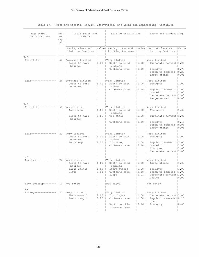
Table 17.--Roads and Streets, Shallow Excavations, and Lawns and Landscaping--Continued ________________________________________________________________________________________________________ | | | | Map symbol |Pct.| Local roads and | Shallow excavations | Lawns and landscaping and soil name | of | streets | | |map | | | |unit| | | | |_________________________|_________________________|_________________________ | | Rating class and |Value| Rating class and |Value| Rating class and |Value | | limiting features | | limiting features | | limiting features | _____________________|____|___________________|_____|___________________|_____|___________________|_____ KrD: | | | | | | | Kerrville-----------| 54 |Somewhat limited | |Very limited | |Very limited | | | Depth to hard |0.20 | Depth to hard |1.00 | Carbonate content|1.00 | | bedrock | | bedrock | | | | | | | Cutbanks cave |0.10 | Droughty |0.93 | | | | | | Depth to bedrock |0.20 | | | | | | Large stones |0.01 | | | | | | | Real----------------| 26 |Somewhat limited | |Very limited | |Very limited | | | Depth to soft |1.00 | Depth to soft |1.00 | Droughty |1.00 | | bedrock | | bedrock | | | | | | | Cutbanks cave |0.10 | Depth to bedrock |1.00 | | | | | | Gravel |1.00 | | | | | | Carbonate content|1.00 | | | | | | Large stones |0.08 | | | | | | | KrF: | | | | | | | Kerrville-----------| 60 |Very limited | |Very limited | |Very limited | | | Too steep |1.00 | Depth to hard |1.00 | Too steep |1.00 | | | | bedrock | | | | | Depth to hard |0.06 | Too steep |1.00 | Carbonate content|1.00 | | bedrock | | | | | | | | | Cutbanks cave |0.10 | Droughty |0.13 | | | | | | Depth to bedrock |0.06 | | | | | | Large stones |0.01 | | | | | | | Real----------------| 21 |Very limited | |Very limited | |Very limited | | | Depth to soft |1.00 | Depth to soft |1.00 | Droughty |1.00 | | bedrock | | bedrock | | | | | Too steep |1.00 | Too steep |1.00 | Depth to bedrock |1.00 | | | | Cutbanks cave |0.10 | Gravel |1.00 | | | | | | Too steep |1.00 | | | | | | Carbonate content|1.00 | | | | | | | LaE: | | | | | | | Langtry-------------| 72 |Very limited | |Very limited | |Very limited | | | Depth to hard |1.00 | Depth to hard |1.00 | Large stones |1.00 | | bedrock | | bedrock | | | | | Large stones |1.00 | Large stones |1.00 | Droughty |1.00 | | Slope |0.01 | Cutbanks cave |0.10 | Depth to bedrock |1.00 | | | | Slope |0.01 | Carbonate content|1.00 | | | | | | Gravel |0.02 | | | | | | | Rock outcrop--------| 10 |Not rated | |Not rated | |Not rated | | | | | | | | LkB: | | | | | | | Leakey--------------| 73 |Very limited | |Very limited | |Very limited | | | Shrink-swell |1.00 | Too clayey |1.00 | Carbonate content|1.00 | | Low strength |0.22 | Cutbanks cave |1.00 | Depth to cemented|0.15 | | | | | | pan | | | | | Depth to thin |0.16 | Droughty |0.03 | | | | cemented pan | | | | | | | | | |
Soil Survey of Edwards and Real Counties, Texas
237

Table 17.--Roads and Streets, Shallow Excavations, and Lawns and Landscaping--Continued ________________________________________________________________________________________________________ | | | | Map symbol |Pct.| Local roads and | Shallow excavations | Lawns and landscaping and soil name | of | streets | | |map | | | |unit| | | | |_________________________|_________________________|_________________________ | | Rating class and |Value| Rating class and |Value| Rating class and |Value | | limiting features | | limiting features | | limiting features | _____________________|____|___________________|_____|___________________|_____|___________________|_____ MaD: | | | | | | | Mailtrail-----------| 67 |Very limited | |Very limited | |Very limited | | | Depth to thin |1.00 | Depth to thin |1.00 | Depth to cemented|1.00 | | cemented pan | | cemented pan | | pan | | | Large stones |1.00 | Large stones |1.00 | Droughty |1.00 | | | | Cutbanks cave |0.10 | Carbonate content|1.00 | | | | | | Large stones |0.97 | | | | | | Gravel |0.87 | | | | | | | MmC: | | | | | | | Mailtrail-----------| 55 |Very limited | |Very limited | |Very limited | | | Depth to thin |1.00 | Depth to thin |1.00 | Depth to cemented|1.00 | | cemented pan | | cemented pan | | pan | | | Large stones |1.00 | Large stones |1.00 | Droughty |1.00 | | | | Cutbanks cave |0.10 | Carbonate content|1.00 | | | | | | Large stones |0.97 | | | | | | Gravel |0.87 | | | | | | | Mereta--------------| 30 |Very limited | |Very limited | |Very limited | | | Depth to thin |1.00 | Depth to thin |1.00 | Depth to cemented|1.00 | | cemented pan | | cemented pan | | pan | | | Low strength |1.00 | Cutbanks cave |0.10 | Droughty |0.16 | | Shrink-swell |0.50 | | | | | | | | | | | NuB: | | | | | | | Nuvalde-------------| 90 |Very limited | |Somewhat limited | |Very limited | | | Low strength |1.00 | Cutbanks cave |0.10 | Carbonate content|1.00 | | Shrink-swell |0.50 | | | | | | Flooding |0.40 | | | | | | | | | | | OdA: | | | | | | | Oakalla, >27 PZ-----| 50 |Very limited | |Somewhat limited | |Very limited | | | Flooding |1.00 | Flooding |0.60 | Carbonate content|1.00 | | Low strength |1.00 | Cutbanks cave |0.10 | Flooding |0.60 | | Shrink-swell |0.50 | | | | | | | | | | | Dev-----------------| 40 |Very limited | |Very limited | |Very limited | | | Flooding |1.00 | Cutbanks cave |1.00 | Flooding |1.00 | | | | Flooding |0.80 | Carbonate content|1.00 | | | | | | Large stones |0.74 | | | | | | Gravel |0.50 | | | | | | Droughty |0.16 | | | | | | | OrA: | | | | | | | Orif----------------| 95 |Very limited | |Very limited | |Very limited | | | Flooding |1.00 | Cutbanks cave |1.00 | Flooding |1.00 | | | | Flooding |0.80 | Carbonate content|1.00 | | | | | | Droughty |0.63 | | | | | | Large stones |0.08 | | | | | | |
Soil Survey of Edwards and Real Counties, Texas
238

Table 17.--Roads and Streets, Shallow Excavations, and Lawns and Landscaping--Continued ________________________________________________________________________________________________________ | | | | Map symbol |Pct.| Local roads and | Shallow excavations | Lawns and landscaping and soil name | of | streets | | |map | | | |unit| | | | |_________________________|_________________________|_________________________ | | Rating class and |Value| Rating class and |Value| Rating class and |Value | | limiting features | | limiting features | | limiting features | _____________________|____|___________________|_____|___________________|_____|___________________|_____ OrG: | | | | | | | Oplin---------------| 53 |Very limited | |Very limited | |Very limited | | | Depth to hard |1.00 | Depth to hard |1.00 | Too steep |1.00 | | bedrock | | bedrock | | | | | Too steep |1.00 | Too steep |1.00 | Droughty |1.00 | | Large stones |0.46 | Large stones |0.46 | Depth to bedrock |1.00 | | | | Cutbanks cave |0.10 | Large stones |1.00 | | | | | | Gravel |0.04 | | | | | | | Rock outcrop--------| 30 |Not rated | |Not rated | |Not rated | | | | | | | | PeB: | | | | | | | Prade---------------| 35 |Very limited | |Very limited | |Very limited | | | Depth to thin |1.00 | Depth to soft |1.00 | Depth to cemented|1.00 | | cemented pan | | bedrock | | pan | | | Depth to soft |1.00 | Depth to thin |1.00 | Droughty |1.00 | | bedrock | | cemented pan | | | | | Low strength |1.00 | Large stones |0.99 | Large stones |1.00 | | Large stones |0.99 | | | Depth to bedrock |1.00 | | Shrink-swell |0.50 | | | Too clayey |1.00 | | | | | | | Eckrant-------------| 28 |Very limited | |Very limited | |Very limited | | | Depth to hard |1.00 | Depth to hard |1.00 | Droughty |1.00 | | bedrock | | bedrock | | | | | Low strength |1.00 | Large stones |1.00 | Depth to bedrock |1.00 | | Large stones |1.00 | Cutbanks cave |0.10 | Large stones |1.00 | | Shrink-swell |0.50 | | | | | | | | | | | PIT: | | | | | | | Pits----------------|100 |Not rated | |Not rated | |Not rated | | | | | | | | PrC: | | | | | | | Prade---------------| 43 |Very limited | |Very limited | |Very limited | | | Depth to thin |1.00 | Depth to soft |1.00 | Depth to cemented|1.00 | | cemented pan | | bedrock | | pan | | | Depth to soft |1.00 | Depth to thin |1.00 | Droughty |1.00 | | bedrock | | cemented pan | | | | | Low strength |1.00 | Large stones |0.99 | Large stones |1.00 | | Large stones |0.99 | | | Depth to bedrock |1.00 | | Shrink-swell |0.50 | | | Too clayey |1.00 | | | | | | | Tarrant, <31 PZ-----| 40 |Very limited | |Very limited | |Very limited | | | Depth to hard |1.00 | Depth to hard |1.00 | Large stones |1.00 | | bedrock | | bedrock | | | | | Large stones |1.00 | Large stones |1.00 | Droughty |1.00 | | Low strength |1.00 | Cutbanks cave |0.10 | Depth to bedrock |1.00 | | Shrink-swell |0.50 | | | Too clayey |1.00 | | | | | | | PtB: | | | | | | | Pratley-------------| 75 |Very limited | |Somewhat limited | |Somewhat limited | | | Low strength |1.00 | Depth to thin |0.90 | Depth to cemented|0.90 | | | | cemented pan | | pan | | | Shrink-swell |1.00 | Too clayey |0.50 | Depth to bedrock |0.46 | | | | Depth to soft |0.46 | Droughty |0.01 | | | | bedrock | | | | | | | Cutbanks cave |0.10 | Large stones |0.01 | | | | | | |
Soil Survey of Edwards and Real Counties, Texas
239
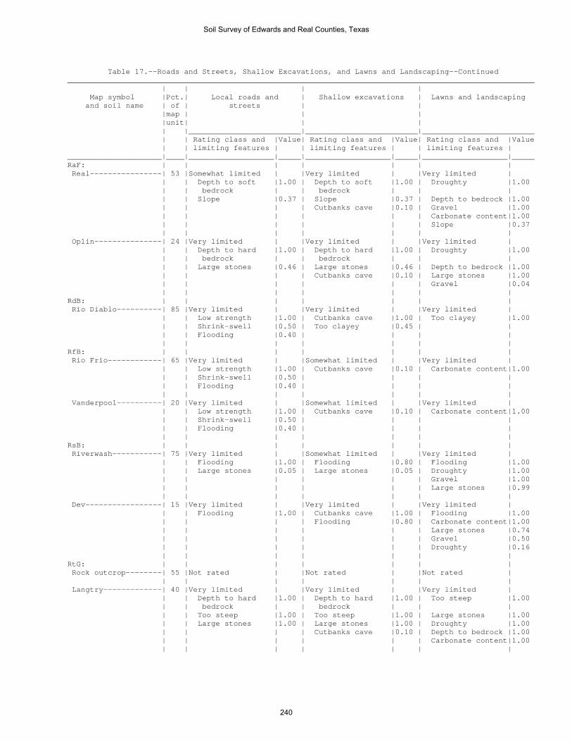
Table 17.--Roads and Streets, Shallow Excavations, and Lawns and Landscaping--Continued ________________________________________________________________________________________________________ | | | | Map symbol |Pct.| Local roads and | Shallow excavations | Lawns and landscaping and soil name | of | streets | | |map | | | |unit| | | | |_________________________|_________________________|_________________________ | | Rating class and |Value| Rating class and |Value| Rating class and |Value | | limiting features | | limiting features | | limiting features | _____________________|____|___________________|_____|___________________|_____|___________________|_____ RaF: | | | | | | | Real----------------| 53 |Somewhat limited | |Very limited | |Very limited | | | Depth to soft |1.00 | Depth to soft |1.00 | Droughty |1.00 | | bedrock | | bedrock | | | | | Slope |0.37 | Slope |0.37 | Depth to bedrock |1.00 | | | | Cutbanks cave |0.10 | Gravel |1.00 | | | | | | Carbonate content|1.00 | | | | | | Slope |0.37 | | | | | | | Oplin---------------| 24 |Very limited | |Very limited | |Very limited | | | Depth to hard |1.00 | Depth to hard |1.00 | Droughty |1.00 | | bedrock | | bedrock | | | | | Large stones |0.46 | Large stones |0.46 | Depth to bedrock |1.00 | | | | Cutbanks cave |0.10 | Large stones |1.00 | | | | | | Gravel |0.04 | | | | | | | RdB: | | | | | | | Rio Diablo----------| 85 |Very limited | |Very limited | |Very limited | | | Low strength |1.00 | Cutbanks cave |1.00 | Too clayey |1.00 | | Shrink-swell |0.50 | Too clayey |0.45 | | | | Flooding |0.40 | | | | | | | | | | | RfB: | | | | | | | Rio Frio------------| 65 |Very limited | |Somewhat limited | |Very limited | | | Low strength |1.00 | Cutbanks cave |0.10 | Carbonate content|1.00 | | Shrink-swell |0.50 | | | | | | Flooding |0.40 | | | | | | | | | | | Vanderpool----------| 20 |Very limited | |Somewhat limited | |Very limited | | | Low strength |1.00 | Cutbanks cave |0.10 | Carbonate content|1.00 | | Shrink-swell |0.50 | | | | | | Flooding |0.40 | | | | | | | | | | | RsB: | | | | | | | Riverwash-----------| 75 |Very limited | |Somewhat limited | |Very limited | | | Flooding |1.00 | Flooding |0.80 | Flooding |1.00 | | Large stones |0.05 | Large stones |0.05 | Droughty |1.00 | | | | | | Gravel |1.00 | | | | | | Large stones |0.99 | | | | | | | Dev-----------------| 15 |Very limited | |Very limited | |Very limited | | | Flooding |1.00 | Cutbanks cave |1.00 | Flooding |1.00 | | | | Flooding |0.80 | Carbonate content|1.00 | | | | | | Large stones |0.74 | | | | | | Gravel |0.50 | | | | | | Droughty |0.16 | | | | | | | RtG: | | | | | | | Rock outcrop--------| 55 |Not rated | |Not rated | |Not rated | | | | | | | | Langtry-------------| 40 |Very limited | |Very limited | |Very limited | | | Depth to hard |1.00 | Depth to hard |1.00 | Too steep |1.00 | | bedrock | | bedrock | | | | | Too steep |1.00 | Too steep |1.00 | Large stones |1.00 | | Large stones |1.00 | Large stones |1.00 | Droughty |1.00 | | | | Cutbanks cave |0.10 | Depth to bedrock |1.00 | | | | | | Carbonate content|1.00 | | | | | | |
Soil Survey of Edwards and Real Counties, Texas
240

Table 17.--Roads and Streets, Shallow Excavations, and Lawns and Landscaping--Continued ________________________________________________________________________________________________________ | | | | Map symbol |Pct.| Local roads and | Shallow excavations | Lawns and landscaping and soil name | of | streets | | |map | | | |unit| | | | |_________________________|_________________________|_________________________ | | Rating class and |Value| Rating class and |Value| Rating class and |Value | | limiting features | | limiting features | | limiting features | _____________________|____|___________________|_____|___________________|_____|___________________|_____ StC: | | | | | | | Spires--------------| 61 |Very limited | |Very limited | |Somewhat limited | | | Low strength |1.00 | Depth to hard |1.00 | Depth to bedrock |0.65 | | | | bedrock | | | | | Shrink-swell |1.00 | Too clayey |0.45 | Droughty |0.16 | | Depth to hard |0.64 | Cutbanks cave |0.10 | Large stones |0.08 | | bedrock | | | | | | | | | | | | Tarpley-------------| 29 |Very limited | |Very limited | |Very limited | | | Depth to hard |1.00 | Depth to hard |1.00 | Depth to bedrock |1.00 | | bedrock | | bedrock | | | | | Shrink-swell |1.00 | Cutbanks cave |0.10 | Droughty |0.99 | | Low strength |1.00 | | | Large stones |0.74 | | | | | | | TeA: | | | | | | | Tarrant, <31 PZ-----| 35 |Very limited | |Very limited | |Very limited | | | Depth to hard |1.00 | Depth to hard |1.00 | Large stones |1.00 | | bedrock | | bedrock | | | | | Large stones |1.00 | Large stones |1.00 | Droughty |1.00 | | Low strength |1.00 | Cutbanks cave |0.10 | Depth to bedrock |1.00 | | Shrink-swell |0.50 | | | Too clayey |1.00 | | | | | | | Eckrant-------------| 30 |Very limited | |Very limited | |Very limited | | | Depth to hard |1.00 | Depth to hard |1.00 | Droughty |1.00 | | bedrock | | bedrock | | | | | Low strength |1.00 | Large stones |0.84 | Depth to bedrock |1.00 | | Large stones |0.84 | Cutbanks cave |0.10 | Large stones |1.00 | | Shrink-swell |0.50 | | | Too clayey |1.00 | | | | | | | TvB: | | | | | | | Tarrant, <31 PZ-----| 43 |Very limited | |Very limited | |Very limited | | | Depth to hard |1.00 | Depth to hard |1.00 | Large stones |1.00 | | bedrock | | bedrock | | | | | Large stones |1.00 | Large stones |1.00 | Droughty |1.00 | | Low strength |1.00 | Cutbanks cave |0.10 | Depth to bedrock |1.00 | | Shrink-swell |0.50 | | | Too clayey |1.00 | | | | | | | Valera--------------| 30 |Very limited | |Very limited | |Very limited | | | Low strength |1.00 | Depth to hard |1.00 | Too clayey |1.00 | | | | bedrock | | | | | Shrink-swell |1.00 | Depth to thin |0.46 | Depth to cemented|0.46 | | | | cemented pan | | pan | | | Depth to hard |0.29 | Too clayey |0.28 | Depth to bedrock |0.29 | | bedrock | | | | | | | | | Cutbanks cave |0.10 | | | | | | | | | VaA: | | | | | | | Valera--------------| 75 |Very limited | |Very limited | |Very limited | | | Low strength |1.00 | Depth to hard |1.00 | Too clayey |1.00 | | | | bedrock | | | | | Shrink-swell |1.00 | Depth to thin |0.29 | Depth to cemented|0.29 | | | | cemented pan | | pan | | | Depth to hard |0.10 | Too clayey |0.28 | Depth to bedrock |0.10 | | bedrock | | | | | | | | | Cutbanks cave |0.10 | | W: | | | | | | | Water---------------|100 |Not rated | |Not rated | |Not rated | | | | | | | | _____________________|____|___________________|_____|___________________|_____|___________________|_____
Soil Survey of Edwards and Real Counties, Texas
241
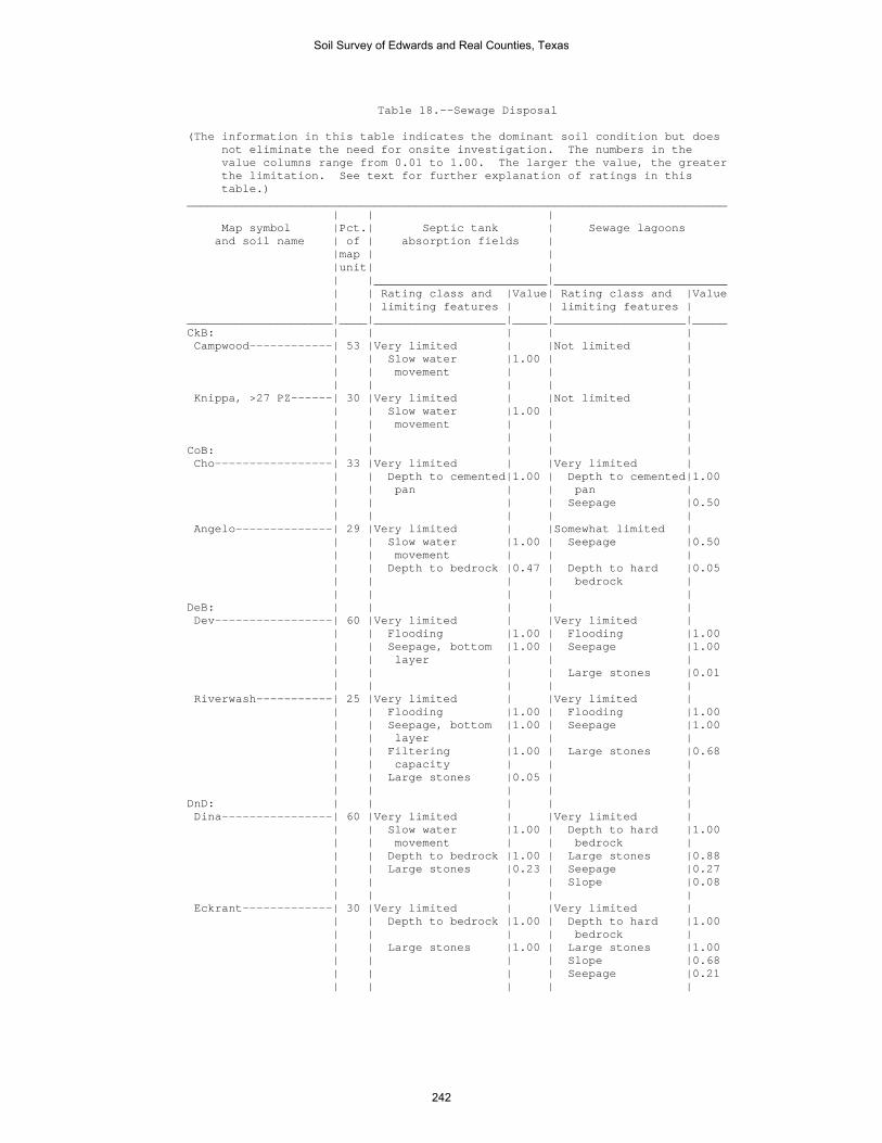
Table 18.--Sewage Disposal (The information in this table indicates the dominant soil condition but does not eliminate the need for onsite investigation. The numbers in the value columns range from 0.01 to 1.00. The larger the value, the greater the limitation. See text for further explanation of ratings in this table.) ______________________________________________________________________________ | | | Map symbol |Pct.| Septic tank | Sewage lagoons and soil name | of | absorption fields | |map | | |unit| | | |_________________________|_________________________ | | Rating class and |Value| Rating class and |Value | | limiting features | | limiting features | _____________________|____|___________________|_____|___________________|_____ CkB: | | | | | Campwood------------| 53 |Very limited | |Not limited | | | Slow water |1.00 | | | | movement | | | | | | | | Knippa, >27 PZ------| 30 |Very limited | |Not limited | | | Slow water |1.00 | | | | movement | | | | | | | | CoB: | | | | | Cho-----------------| 33 |Very limited | |Very limited | | | Depth to cemented|1.00 | Depth to cemented|1.00 | | pan | | pan | | | | | Seepage |0.50 | | | | | Angelo--------------| 29 |Very limited | |Somewhat limited | | | Slow water |1.00 | Seepage |0.50 | | movement | | | | | Depth to bedrock |0.47 | Depth to hard |0.05 | | | | bedrock | | | | | | DeB: | | | | | Dev-----------------| 60 |Very limited | |Very limited | | | Flooding |1.00 | Flooding |1.00 | | Seepage, bottom |1.00 | Seepage |1.00 | | layer | | | | | | | Large stones |0.01 | | | | | Riverwash-----------| 25 |Very limited | |Very limited | | | Flooding |1.00 | Flooding |1.00 | | Seepage, bottom |1.00 | Seepage |1.00 | | layer | | | | | Filtering |1.00 | Large stones |0.68 | | capacity | | | | | Large stones |0.05 | | | | | | | DnD: | | | | | Dina----------------| 60 |Very limited | |Very limited | | | Slow water |1.00 | Depth to hard |1.00 | | movement | | bedrock | | | Depth to bedrock |1.00 | Large stones |0.88 | | Large stones |0.23 | Seepage |0.27 | | | | Slope |0.08 | | | | | Eckrant-------------| 30 |Very limited | |Very limited | | | Depth to bedrock |1.00 | Depth to hard |1.00 | | | | bedrock | | | Large stones |1.00 | Large stones |1.00 | | | | Slope |0.68 | | | | Seepage |0.21 | | | | |
Soil Survey of Edwards and Real Counties, Texas
242

Table 18.--Sewage Disposal--Continued ______________________________________________________________________________ | | | Map symbol |Pct.| Septic tank | Sewage lagoons and soil name | of | absorption fields | |map | | |unit| | | |_________________________|_________________________ | | Rating class and |Value| Rating class and |Value | | limiting features | | limiting features | _____________________|____|___________________|_____|___________________|_____ EcF: | | | | | Eckrant-------------| 67 |Very limited | |Very limited | | | Depth to bedrock |1.00 | Depth to hard |1.00 | | | | bedrock | | | Large stones |0.92 | Slope |1.00 | | Slope |0.37 | Seepage |0.21 | | | | Large stones |0.01 | | | | | Rock outcrop--------| 13 |Not rated | |Not rated | | | | | | EcG: | | | | | Eckrant-------------| 50 |Very limited | |Very limited | | | Depth to bedrock |1.00 | Depth to hard |1.00 | | | | bedrock | | | Too steep |1.00 | Slope |1.00 | | Large stones |0.92 | Seepage |0.21 | | | | Large stones |0.16 | | | | | Rock outcrop--------| 33 |Not rated | |Not rated | | | | | | ErB: | | | | | Ector---------------| 90 |Very limited | |Very limited | | | Depth to bedrock |1.00 | Depth to hard |1.00 | | | | bedrock | | | Large stones |0.88 | Seepage |0.21 | | | | | ErF: | | | | | Ector---------------| 71 |Very limited | |Very limited | | | Depth to bedrock |1.00 | Depth to hard |1.00 | | | | bedrock | | | Large stones |1.00 | Slope |1.00 | | Slope |0.37 | Seepage |0.21 | | | | Large stones |0.01 | | | | | Rock outcrop--------| 16 |Not rated | |Not rated | | | | | | ErG: | | | | | Ector---------------| 61 |Very limited | |Very limited | | | Depth to bedrock |1.00 | Depth to hard |1.00 | | | | bedrock | | | Too steep |1.00 | Slope |1.00 | | Large stones |1.00 | Large stones |0.91 | | | | Seepage |0.21 | | | | | Rock outcrop--------| 35 |Not rated | |Not rated | | | | | | IrA: | | | | | Irion---------------| 90 |Very limited | |Very limited | | | Slow water |1.00 | Ponding |1.00 | | movement | | | | | Ponding |1.00 | | | | | | |
Soil Survey of Edwards and Real Counties, Texas
243

Table 18.--Sewage Disposal--Continued ______________________________________________________________________________ | | | Map symbol |Pct.| Septic tank | Sewage lagoons and soil name | of | absorption fields | |map | | |unit| | | |_________________________|_________________________ | | Rating class and |Value| Rating class and |Value | | limiting features | | limiting features | _____________________|____|___________________|_____|___________________|_____ KrD: | | | | | Kerrville-----------| 54 |Very limited | |Very limited | | | Depth to bedrock |1.00 | Depth to hard |1.00 | | | | bedrock | | | Slow water |0.50 | Slope |0.68 | | movement | | | | | | | Seepage |0.50 | | | | | Real----------------| 26 |Very limited | |Very limited | | | Depth to bedrock |1.00 | Depth to soft |1.00 | | | | bedrock | | | | | Slope |0.68 | | | | Seepage |0.27 | | | | | KrF: | | | | | Kerrville-----------| 60 |Very limited | |Very limited | | | Depth to bedrock |1.00 | Depth to hard |1.00 | | | | bedrock | | | Too steep |1.00 | Slope |1.00 | | Slow water |0.50 | Seepage |0.50 | | movement | | | | | | | | Real----------------| 21 |Very limited | |Very limited | | | Depth to bedrock |1.00 | Depth to soft |1.00 | | | | bedrock | | | Too steep |1.00 | Slope |1.00 | | | | Seepage |0.27 | | | | | LaE: | | | | | Langtry-------------| 72 |Very limited | |Very limited | | | Depth to bedrock |1.00 | Depth to hard |1.00 | | | | bedrock | | | Large stones |1.00 | Large stones |1.00 | | Slope |0.01 | Slope |1.00 | | | | Seepage |0.50 | | | | | Rock outcrop--------| 10 |Not rated | |Not rated | | | | | | LkB: | | | | | Leakey--------------| 73 |Very limited | |Very limited | | | Slow water |1.00 | Depth to cemented|1.00 | | movement | | pan | | | Depth to cemented|1.00 | | | | pan | | | | | | | | MaD: | | | | | Mailtrail-----------| 67 |Very limited | |Very limited | | | Depth to cemented|1.00 | Depth to cemented|1.00 | | pan | | pan | | | Large stones |1.00 | Large stones |1.00 | | | | Slope |0.68 | | | | Seepage |0.50 | | | | |
Soil Survey of Edwards and Real Counties, Texas
244

Table 18.--Sewage Disposal--Continued ______________________________________________________________________________ | | | Map symbol |Pct.| Septic tank | Sewage lagoons and soil name | of | absorption fields | |map | | |unit| | | |_________________________|_________________________ | | Rating class and |Value| Rating class and |Value | | limiting features | | limiting features | _____________________|____|___________________|_____|___________________|_____ MmC: | | | | | Mailtrail-----------| 55 |Very limited | |Very limited | | | Depth to cemented|1.00 | Depth to cemented|1.00 | | pan | | pan | | | Large stones |1.00 | Large stones |1.00 | | | | Seepage |0.50 | | | | Slope |0.08 | | | | | Mereta--------------| 30 |Very limited | |Very limited | | | Depth to cemented|1.00 | Depth to cemented|1.00 | | pan | | pan | | | | | | NuB: | | | | | Nuvalde-------------| 90 |Somewhat limited | |Somewhat limited | | | Slow water |0.50 | Seepage |0.50 | | movement | | | | | Flooding |0.40 | Flooding |0.40 | | | | | OdA: | | | | | Oakalla, >27 PZ-----| 50 |Very limited | |Very limited | | | Flooding |1.00 | Flooding |1.00 | | Slow water |0.50 | Seepage |0.50 | | movement | | | | | | | | Dev-----------------| 40 |Very limited | |Very limited | | | Flooding |1.00 | Flooding |1.00 | | Seepage, bottom |1.00 | Seepage |1.00 | | layer | | | | | | | Large stones |0.01 | | | | | OrA: | | | | | Orif----------------| 95 |Very limited | |Very limited | | | Flooding |1.00 | Flooding |1.00 | | Seepage, bottom |1.00 | Seepage |1.00 | | layer | | | | | Filtering |1.00 | | | | capacity | | | | | | | | OrG: | | | | | Oplin---------------| 53 |Very limited | |Very limited | | | Depth to bedrock |1.00 | Depth to hard |1.00 | | | | bedrock | | | Too steep |1.00 | Slope |1.00 | | Large stones |0.46 | Seepage |0.27 | | | | | Rock outcrop--------| 30 |Not rated | |Not rated | | | | | |
Soil Survey of Edwards and Real Counties, Texas
245

Table 18.--Sewage Disposal--Continued ______________________________________________________________________________ | | | Map symbol |Pct.| Septic tank | Sewage lagoons and soil name | of | absorption fields | |map | | |unit| | | |_________________________|_________________________ | | Rating class and |Value| Rating class and |Value | | limiting features | | limiting features | _____________________|____|___________________|_____|___________________|_____ PeB: | | | | | Prade---------------| 35 |Very limited | |Very limited | | | Depth to bedrock |1.00 | Depth to soft |1.00 | | | | bedrock | | | Depth to cemented|1.00 | Depth to cemented|1.00 | | pan | | pan | | | Large stones |0.99 | Large stones |1.00 | | | | Seepage |0.21 | | | | | Eckrant-------------| 28 |Very limited | |Very limited | | | Depth to bedrock |1.00 | Depth to hard |1.00 | | | | bedrock | | | Large stones |1.00 | Large stones |0.99 | | | | Seepage |0.21 | | | | | PIT: | | | | | Pits----------------|100 |Not rated | |Not rated | | | | | | PrC: | | | | | Prade---------------| 43 |Very limited | |Very limited | | | Depth to bedrock |1.00 | Depth to soft |1.00 | | | | bedrock | | | Depth to cemented|1.00 | Depth to cemented|1.00 | | pan | | pan | | | Large stones |0.99 | Large stones |0.66 | | | | Slope |0.32 | | | | Seepage |0.21 | | | | | Tarrant, <31 PZ-----| 40 |Very limited | |Very limited | | | Depth to bedrock |1.00 | Depth to hard |1.00 | | | | bedrock | | | Large stones |1.00 | Large stones |1.00 | | | | Slope |0.32 | | | | Seepage |0.21 | | | | | PtB: | | | | | Pratley-------------| 75 |Very limited | |Very limited | | | Depth to cemented|1.00 | Depth to soft |1.00 | | pan | | bedrock | | | Slow water |1.00 | Depth to cemented|1.00 | | movement | | pan | | | Depth to bedrock |1.00 | Seepage |0.21 | | | | | RaF: | | | | | Real----------------| 53 |Very limited | |Very limited | | | Depth to bedrock |1.00 | Depth to soft |1.00 | | | | bedrock | | | Slope |0.37 | Slope |1.00 | | | | Seepage |0.50 | | | | | Oplin---------------| 24 |Very limited | |Very limited | | | Depth to bedrock |1.00 | Depth to hard |1.00 | | | | bedrock | | | Large stones |0.46 | Slope |0.92 | | | | Seepage |0.27 | | | | |
Soil Survey of Edwards and Real Counties, Texas
246

Table 18.--Sewage Disposal--Continued ______________________________________________________________________________ | | | Map symbol |Pct.| Septic tank | Sewage lagoons and soil name | of | absorption fields | |map | | |unit| | | |_________________________|_________________________ | | Rating class and |Value| Rating class and |Value | | limiting features | | limiting features | _____________________|____|___________________|_____|___________________|_____ RdB: | | | | | Rio Diablo----------| 85 |Very limited | |Somewhat limited | | | Slow water |1.00 | Flooding |0.40 | | movement | | | | | Flooding |0.40 | | | | | | | RfB: | | | | | Rio Frio------------| 65 |Somewhat limited | |Somewhat limited | | | Slow water |0.50 | Seepage |0.50 | | movement | | | | | Flooding |0.40 | Flooding |0.40 | | | | | Vanderpool----------| 20 |Somewhat limited | |Somewhat limited | | | Slow water |0.50 | Seepage |0.50 | | movement | | | | | Flooding |0.40 | Flooding |0.40 | | | | | RsB: | | | | | Riverwash-----------| 75 |Very limited | |Very limited | | | Flooding |1.00 | Flooding |1.00 | | Seepage, bottom |1.00 | Seepage |1.00 | | layer | | | | | Filtering |1.00 | Large stones |0.68 | | capacity | | | | | Large stones |0.05 | | | | | | | Dev-----------------| 15 |Very limited | |Very limited | | | Flooding |1.00 | Flooding |1.00 | | Seepage, bottom |1.00 | Seepage |1.00 | | layer | | | | | | | Large stones |0.01 | | | | | RtG: | | | | | Rock outcrop--------| 55 |Not rated | |Not rated | | | | | | Langtry-------------| 40 |Very limited | |Very limited | | | Depth to bedrock |1.00 | Depth to hard |1.00 | | | | bedrock | | | Too steep |1.00 | Slope |1.00 | | Large stones |1.00 | Large stones |1.00 | | | | Seepage |0.50 | | | | | StC: | | | | | Spires--------------| 61 |Very limited | |Very limited | | | Slow water |1.00 | Depth to hard |1.00 | | movement | | bedrock | | | Depth to bedrock |1.00 | Seepage |0.27 | | | | Slope |0.08 | | | | | Tarpley-------------| 29 |Very limited | |Very limited | | | Depth to bedrock |1.00 | Depth to hard |1.00 | | | | bedrock | | | | | Seepage |0.27 | | | | Slope |0.08 | | | | |
Soil Survey of Edwards and Real Counties, Texas
247

Table 18.--Sewage Disposal--Continued ______________________________________________________________________________ | | | Map symbol |Pct.| Septic tank | Sewage lagoons and soil name | of | absorption fields | |map | | |unit| | | |_________________________|_________________________ | | Rating class and |Value| Rating class and |Value | | limiting features | | limiting features | _____________________|____|___________________|_____|___________________|_____ TeA: | | | | | Tarrant, <31 PZ-----| 35 |Very limited | |Very limited | | | Depth to bedrock |1.00 | Depth to hard |1.00 | | | | bedrock | | | Large stones |1.00 | Large stones |1.00 | | | | Seepage |0.21 | | | | | Eckrant-------------| 30 |Very limited | |Very limited | | | Depth to bedrock |1.00 | Depth to hard |1.00 | | | | bedrock | | | Large stones |0.84 | Seepage |0.21 | | | | | TvB: | | | | | Tarrant, <31 PZ-----| 43 |Very limited | |Very limited | | | Depth to bedrock |1.00 | Depth to hard |1.00 | | | | bedrock | | | Large stones |1.00 | Large stones |1.00 | | | | Seepage |0.21 | | | | | Valera--------------| 30 |Very limited | |Very limited | | | Depth to cemented|1.00 | Depth to hard |1.00 | | pan | | bedrock | | | Slow water |1.00 | Depth to cemented|1.00 | | movement | | pan | | | Depth to bedrock |1.00 | Seepage |0.27 | | | | | VaA: | | | | | Valera--------------| 75 |Very limited | |Very limited | | | Depth to cemented|1.00 | Depth to hard |1.00 | | pan | | bedrock | | | Slow water |1.00 | Depth to cemented|1.00 | | movement | | pan | | | Depth to bedrock |1.00 | Seepage |0.27 | | | | | W: | | | | | Water---------------|100 |Not rated | |Not rated | | | | | | _____________________|____|___________________|_____|___________________|_____
Soil Survey of Edwards and Real Counties, Texas
248

Table 19.--Landfills (The information in this table indicates the dominant soil condition but does not eliminate the need for onsite investigation. The numbers in the value columns range from 0.01 to 1.00. The larger the value, the greater the limitation. See text for further explanation of ratings in this table.) ________________________________________________________________________________________________________ | | | | Map symbol |Pct.| Trench sanitary | Area sanitary | Daily cover for and soil name | of | landfill | landfill | landfill |map | | | |unit| | | | |_________________________|_________________________|_________________________ | | Rating class and |Value| Rating class and |Value| Rating class and |Value | | limiting features | | limiting features | | limiting features | _____________________|____|___________________|_____|___________________|_____|___________________|_____ CkB: | | | | | | | Campwood------------| 53 |Very limited | |Not limited | |Very limited | | | Too clayey |1.00 | | | Too clayey |1.00 | | | | | | Hard to compact |1.00 | | | | | | | Knippa, >27 PZ------| 30 |Very limited | |Not limited | |Very limited | | | Too clayey |1.00 | | | Too clayey |1.00 | | | | | | Hard to compact |1.00 | | | | | | Carbonate content|1.00 | | | | | | | CoB: | | | | | | | Cho-----------------| 33 |Somewhat limited | |Very limited | |Very limited | | | Depth to thin |0.50 | Depth to cemented|1.00 | Depth to cemented|1.00 | | cemented pan | | pan | | pan | | | | | | | Carbonate content|1.00 | | | | | | Gravel content |0.14 | | | | | | | Angelo--------------| 29 |Very limited | |Not limited | |Somewhat limited | | | Depth to bedrock |1.00 | | | Depth to bedrock |0.05 | | | | | | | DeB: | | | | | | | Dev-----------------| 60 |Very limited | |Very limited | |Very limited | | | Flooding |1.00 | Flooding |1.00 | Seepage |1.00 | | Seepage, bottom |1.00 | Seepage |1.00 | Carbonate content|1.00 | | layer | | | | | | | | | | | Gravel content |0.87 | | | | | | | Riverwash-----------| 25 |Very limited | |Very limited | |Very limited | | | Flooding |1.00 | Flooding |1.00 | Seepage |1.00 | | Seepage, bottom |1.00 | Seepage |1.00 | Gravel content |1.00 | | layer | | | | | | | Large stones |0.05 | Not rated |1.00 | Large stones |0.05 | | | | | | | DnD: | | | | | | | Dina----------------| 60 |Very limited | |Very limited | |Very limited | | | Depth to bedrock |1.00 | Depth to bedrock |1.00 | Too clayey |1.00 | | Too clayey |1.00 | | | Depth to bedrock |1.00 | | Large stones |0.23 | | | Gravel content |0.74 | | | | | | Large stones |0.23 | | | | | | | Eckrant-------------| 30 |Very limited | |Very limited | |Very limited | | | Depth to bedrock |1.00 | Depth to bedrock |1.00 | Depth to bedrock |1.00 | | Too clayey |1.00 | | | Too clayey |1.00 | | Large stones |1.00 | | | Hard to compact |1.00 | | | | | | Large stones |1.00 | | | | | | |
Soil Survey of Edwards and Real Counties, Texas
249

Table 19.--Landfills--Continued ________________________________________________________________________________________________________ | | | | Map symbol |Pct.| Trench sanitary | Area sanitary | Daily cover for and soil name | of | landfill | landfill | landfill |map | | | |unit| | | | |_________________________|_________________________|_________________________ | | Rating class and |Value| Rating class and |Value| Rating class and |Value | | limiting features | | limiting features | | limiting features | _____________________|____|___________________|_____|___________________|_____|___________________|_____ EcF: | | | | | | | Eckrant-------------| 67 |Very limited | |Very limited | |Very limited | | | Depth to bedrock |1.00 | Depth to bedrock |1.00 | Depth to bedrock |1.00 | | Too clayey |1.00 | Slope |0.37 | Too clayey |1.00 | | Large stones |0.92 | | | Large stones |0.92 | | Slope |0.37 | | | Slope |0.37 | | | | | | | Rock outcrop--------| 13 |Not rated | |Very limited | |Not rated | | | | | Depth to bedrock |1.00 | | | | | | Not rated |1.00 | | | | | | Seepage |1.00 | | | | | | Slope |0.37 | | | | | | | | | EcG: | | | | | | | Eckrant-------------| 50 |Very limited | |Very limited | |Very limited | | | Too steep |1.00 | Too steep |1.00 | Depth to bedrock |1.00 | | Depth to bedrock |1.00 | Depth to bedrock |1.00 | Too steep |1.00 | | Large stones |0.92 | | | Large stones |0.92 | | | | | | | Rock outcrop--------| 33 |Not rated | |Very limited | |Not rated | | | | | Too steep |1.00 | | | | | | Depth to bedrock |1.00 | | | | | | Not rated |1.00 | | | | | | Seepage |1.00 | | | | | | | | | ErB: | | | | | | | Ector---------------| 90 |Very limited | |Very limited | |Very limited | | | Depth to bedrock |1.00 | Depth to bedrock |1.00 | Depth to bedrock |1.00 | | Large stones |0.88 | | | Carbonate content|1.00 | | Too clayey |0.50 | | | Large stones |0.88 | | | | | | Too clayey |0.50 | | | | | | Gravel content |0.03 | | | | | | | ErF: | | | | | | | Ector---------------| 71 |Very limited | |Very limited | |Very limited | | | Depth to bedrock |1.00 | Depth to bedrock |1.00 | Depth to bedrock |1.00 | | Large stones |1.00 | Slope |0.37 | Carbonate content|1.00 | | Slope |0.37 | | | Large stones |1.00 | | | | | | Slope |0.37 | | | | | | | Rock outcrop--------| 16 |Not rated | |Very limited | |Not rated | | | | | Depth to bedrock |1.00 | | | | | | Not rated |1.00 | | | | | | Seepage |1.00 | | | | | | Slope |0.37 | | | | | | | | | ErG: | | | | | | | Ector---------------| 61 |Very limited | |Very limited | |Very limited | | | Too steep |1.00 | Too steep |1.00 | Depth to bedrock |1.00 | | Depth to bedrock |1.00 | Depth to bedrock |1.00 | Too steep |1.00 | | Large stones |1.00 | | | Carbonate content|1.00 | | | | | | Large stones |1.00 | | | | | | | Rock outcrop--------| 35 |Not rated | |Very limited | |Not rated | | | | | Too steep |1.00 | | | | | | Depth to bedrock |1.00 | | | | | | Not rated |1.00 | | | | | | Seepage |1.00 | | | | | | | | |
Soil Survey of Edwards and Real Counties, Texas
250

Table 19.--Landfills--Continued ________________________________________________________________________________________________________ | | | | Map symbol |Pct.| Trench sanitary | Area sanitary | Daily cover for and soil name | of | landfill | landfill | landfill |map | | | |unit| | | | |_________________________|_________________________|_________________________ | | Rating class and |Value| Rating class and |Value| Rating class and |Value | | limiting features | | limiting features | | limiting features | _____________________|____|___________________|_____|___________________|_____|___________________|_____ IrA: | | | | | | | Irion---------------| 90 |Very limited | |Very limited | |Very limited | | | Ponding |1.00 | Ponding |1.00 | Ponding |1.00 | | Too clayey |1.00 | | | Too clayey |1.00 | | Depth to bedrock |1.00 | | | Hard to compact |1.00 | | | | | | | KrD: | | | | | | | Kerrville-----------| 54 |Very limited | |Very limited | |Very limited | | | Depth to bedrock |1.00 | Depth to bedrock |1.00 | Gravel content |1.00 | | Too clayey |0.50 | | | Depth to bedrock |1.00 | | | | | | Carbonate content|1.00 | | | | | | Too clayey |0.50 | | | | | | | Real----------------| 26 |Very limited | |Very limited | |Very limited | | | Depth to bedrock |1.00 | Depth to bedrock |1.00 | Depth to bedrock |1.00 | | Too clayey |0.50 | | | Gravel content |1.00 | | | | | | Carbonate content|1.00 | | | | | | Too clayey |0.50 | | | | | | | KrF: | | | | | | | Kerrville-----------| 60 |Very limited | |Very limited | |Very limited | | | Depth to bedrock |1.00 | Depth to bedrock |1.00 | Depth to bedrock |1.00 | | Too steep |1.00 | Too steep |1.00 | Too steep |1.00 | | Too clayey |0.50 | | | Carbonate content|1.00 | | | | | | Gravel content |0.68 | | | | | | Too clayey |0.50 | | | | | | | Real----------------| 21 |Very limited | |Very limited | |Very limited | | | Depth to bedrock |1.00 | Depth to bedrock |1.00 | Depth to bedrock |1.00 | | Too steep |1.00 | Too steep |1.00 | Gravel content |1.00 | | | | | | Too steep |1.00 | | | | | | | LaE: | | | | | | | Langtry-------------| 72 |Very limited | |Very limited | |Very limited | | | Depth to bedrock |1.00 | Depth to bedrock |1.00 | Depth to bedrock |1.00 | | Large stones |1.00 | Slope |0.01 | Large stones |1.00 | | Slope |0.01 | | | Carbonate content|1.00 | | | | | | Slope |0.01 | | | | | | | Rock outcrop--------| 10 |Not rated | |Very limited | |Not rated | | | | | Depth to bedrock |1.00 | | | | | | Not rated |1.00 | | | | | | Seepage |1.00 | | | | | | Slope |0.01 | | | | | | | | | LkB: | | | | | | | Leakey--------------| 73 |Very limited | |Very limited | |Very limited | | | Too clayey |1.00 | Depth to cemented|1.00 | Depth to cemented|1.00 | | | | pan | | pan | | | Depth to thin |0.50 | | | Too clayey |1.00 | | cemented pan | | | | | | | | | | | |
Soil Survey of Edwards and Real Counties, Texas
251

Table 19.--Landfills--Continued ________________________________________________________________________________________________________ | | | | Map symbol |Pct.| Trench sanitary | Area sanitary | Daily cover for and soil name | of | landfill | landfill | landfill |map | | | |unit| | | | |_________________________|_________________________|_________________________ | | Rating class and |Value| Rating class and |Value| Rating class and |Value | | limiting features | | limiting features | | limiting features | _____________________|____|___________________|_____|___________________|_____|___________________|_____ MaD: | | | | | | | Mailtrail-----------| 67 |Very limited | |Very limited | |Very limited | | | Large stones |1.00 | Depth to cemented|1.00 | Depth to cemented|1.00 | | | | pan | | pan | | | Depth to thin |0.50 | | | Carbonate content|1.00 | | cemented pan | | | | | | | Too clayey |0.50 | | | Large stones |1.00 | | | | | | Too clayey |0.50 | | | | | | | MmC: | | | | | | | Mailtrail-----------| 55 |Very limited | |Very limited | |Very limited | | | Large stones |1.00 | Depth to cemented|1.00 | Depth to cemented|1.00 | | | | pan | | pan | | | Depth to thin |0.50 | | | Carbonate content|1.00 | | cemented pan | | | | | | | Too clayey |0.50 | | | Large stones |1.00 | | | | | | Too clayey |0.50 | | | | | | | Mereta--------------| 30 |Somewhat limited | |Very limited | |Very limited | | | Depth to thin |0.50 | Depth to cemented|1.00 | Depth to cemented|1.00 | | cemented pan | | pan | | pan | | | Too clayey |0.50 | | | Too clayey |0.50 | | | | | | | NuB: | | | | | | | Nuvalde-------------| 90 |Somewhat limited | |Somewhat limited | |Very limited | | | Too clayey |0.50 | Flooding |0.40 | Carbonate content|1.00 | | Flooding |0.40 | | | Too clayey |0.50 | | | | | | | OdA: | | | | | | | Oakalla, >27 PZ-----| 50 |Very limited | |Very limited | |Very limited | | | Flooding |1.00 | Flooding |1.00 | Hard to compact |1.00 | | Too clayey |0.50 | | | Carbonate content|1.00 | | | | | | Too clayey |0.50 | | | | | | | Dev-----------------| 40 |Very limited | |Very limited | |Very limited | | | Flooding |1.00 | Flooding |1.00 | Seepage |1.00 | | Seepage, bottom |1.00 | Seepage |1.00 | Carbonate content|1.00 | | layer | | | | | | | | | | | Gravel content |0.87 | | | | | | | OrA: | | | | | | | Orif----------------| 95 |Very limited | |Very limited | |Very limited | | | Flooding |1.00 | Flooding |1.00 | Too sandy |1.00 | | Seepage, bottom |1.00 | Seepage |1.00 | Seepage |1.00 | | layer | | | | | | | Too sandy |1.00 | | | Gravel content |1.00 | | | | | | Carbonate content|1.00 | | | | | | |
Soil Survey of Edwards and Real Counties, Texas
252
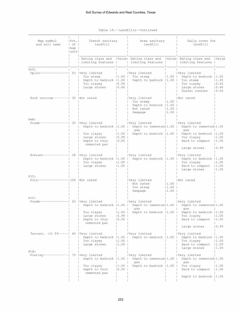
Table 19.--Landfills--Continued ________________________________________________________________________________________________________ | | | | Map symbol |Pct.| Trench sanitary | Area sanitary | Daily cover for and soil name | of | landfill | landfill | landfill |map | | | |unit| | | | |_________________________|_________________________|_________________________ | | Rating class and |Value| Rating class and |Value| Rating class and |Value | | limiting features | | limiting features | | limiting features | _____________________|____|___________________|_____|___________________|_____|___________________|_____ OrG: | | | | | | | Oplin---------------| 53 |Very limited | |Very limited | |Very limited | | | Too steep |1.00 | Too steep |1.00 | Depth to bedrock |1.00 | | Depth to bedrock |1.00 | Depth to bedrock |1.00 | Too steep |1.00 | | Too clayey |0.50 | | | Too clayey |0.50 | | Large stones |0.46 | | | Large stones |0.46 | | | | | | Gravel content |0.04 | | | | | | | Rock outcrop--------| 30 |Not rated | |Very limited | |Not rated | | | | | Too steep |1.00 | | | | | | Depth to bedrock |1.00 | | | | | | Not rated |1.00 | | | | | | Seepage |1.00 | | | | | | | | | PeB: | | | | | | | Prade---------------| 35 |Very limited | |Very limited | |Very limited | | | Depth to bedrock |1.00 | Depth to cemented|1.00 | Depth to cemented|1.00 | | | | pan | | pan | | | Too clayey |1.00 | Depth to bedrock |1.00 | Depth to bedrock |1.00 | | Large stones |0.99 | | | Too clayey |1.00 | | Depth to thin |0.50 | | | Hard to compact |1.00 | | cemented pan | | | | | | | | | | | Large stones |0.99 | | | | | | | Eckrant-------------| 28 |Very limited | |Very limited | |Very limited | | | Depth to bedrock |1.00 | Depth to bedrock |1.00 | Depth to bedrock |1.00 | | Too clayey |1.00 | | | Too clayey |1.00 | | Large stones |1.00 | | | Hard to compact |1.00 | | | | | | Large stones |1.00 | | | | | | | PIT: | | | | | | | Pits----------------|100 |Not rated | |Very limited | |Not rated | | | | | Not rated |1.00 | | | | | | Too steep |1.00 | | | | | | Seepage |1.00 | | | | | | | | | PrC: | | | | | | | Prade---------------| 43 |Very limited | |Very limited | |Very limited | | | Depth to bedrock |1.00 | Depth to cemented|1.00 | Depth to cemented|1.00 | | | | pan | | pan | | | Too clayey |1.00 | Depth to bedrock |1.00 | Depth to bedrock |1.00 | | Large stones |0.99 | | | Too clayey |1.00 | | Depth to thin |0.50 | | | Hard to compact |1.00 | | cemented pan | | | | | | | | | | | Large stones |0.99 | | | | | | | Tarrant, <31 PZ-----| 40 |Very limited | |Very limited | |Very limited | | | Depth to bedrock |1.00 | Depth to bedrock |1.00 | Depth to bedrock |1.00 | | Too clayey |1.00 | | | Too clayey |1.00 | | Large stones |1.00 | | | Hard to compact |1.00 | | | | | | Large stones |1.00 PtB: | | | | | | | Pratley-------------| 75 |Very limited | |Very limited | |Very limited | | | Depth to bedrock |1.00 | Depth to cemented|1.00 | Depth to cemented|1.00 | | | | pan | | pan | | | Too clayey |1.00 | Depth to bedrock |1.00 | Too clayey |1.00 | | Depth to thin |0.50 | | | Hard to compact |1.00 | | cemented pan | | | | | | | | | | | Depth to bedrock |1.00 | | | | | | |
Soil Survey of Edwards and Real Counties, Texas
253
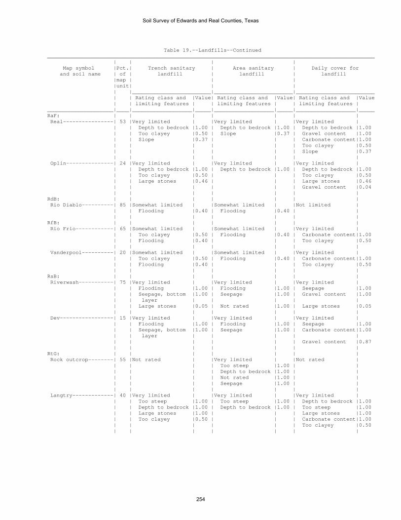
Table 19.--Landfills--Continued ________________________________________________________________________________________________________ | | | | Map symbol |Pct.| Trench sanitary | Area sanitary | Daily cover for and soil name | of | landfill | landfill | landfill |map | | | |unit| | | | |_________________________|_________________________|_________________________ | | Rating class and |Value| Rating class and |Value| Rating class and |Value | | limiting features | | limiting features | | limiting features | _____________________|____|___________________|_____|___________________|_____|___________________|_____ RaF: | | | | | | | Real----------------| 53 |Very limited | |Very limited | |Very limited | | | Depth to bedrock |1.00 | Depth to bedrock |1.00 | Depth to bedrock |1.00 | | Too clayey |0.50 | Slope |0.37 | Gravel content |1.00 | | Slope |0.37 | | | Carbonate content|1.00 | | | | | | Too clayey |0.50 | | | | | | Slope |0.37 | | | | | | | Oplin---------------| 24 |Very limited | |Very limited | |Very limited | | | Depth to bedrock |1.00 | Depth to bedrock |1.00 | Depth to bedrock |1.00 | | Too clayey |0.50 | | | Too clayey |0.50 | | Large stones |0.46 | | | Large stones |0.46 | | | | | | Gravel content |0.04 | | | | | | | RdB: | | | | | | | Rio Diablo----------| 85 |Somewhat limited | |Somewhat limited | |Not limited | | | Flooding |0.40 | Flooding |0.40 | | | | | | | | | RfB: | | | | | | | Rio Frio------------| 65 |Somewhat limited | |Somewhat limited | |Very limited | | | Too clayey |0.50 | Flooding |0.40 | Carbonate content|1.00 | | Flooding |0.40 | | | Too clayey |0.50 | | | | | | | Vanderpool----------| 20 |Somewhat limited | |Somewhat limited | |Very limited | | | Too clayey |0.50 | Flooding |0.40 | Carbonate content|1.00 | | Flooding |0.40 | | | Too clayey |0.50 | | | | | | | RsB: | | | | | | | Riverwash-----------| 75 |Very limited | |Very limited | |Very limited | | | Flooding |1.00 | Flooding |1.00 | Seepage |1.00 | | Seepage, bottom |1.00 | Seepage |1.00 | Gravel content |1.00 | | layer | | | | | | | Large stones |0.05 | Not rated |1.00 | Large stones |0.05 | | | | | | | Dev-----------------| 15 |Very limited | |Very limited | |Very limited | | | Flooding |1.00 | Flooding |1.00 | Seepage |1.00 | | Seepage, bottom |1.00 | Seepage |1.00 | Carbonate content|1.00 | | layer | | | | | | | | | | | Gravel content |0.87 | | | | | | | RtG: | | | | | | | Rock outcrop--------| 55 |Not rated | |Very limited | |Not rated | | | | | Too steep |1.00 | | | | | | Depth to bedrock |1.00 | | | | | | Not rated |1.00 | | | | | | Seepage |1.00 | | | | | | | | | Langtry-------------| 40 |Very limited | |Very limited | |Very limited | | | Too steep |1.00 | Too steep |1.00 | Depth to bedrock |1.00 | | Depth to bedrock |1.00 | Depth to bedrock |1.00 | Too steep |1.00 | | Large stones |1.00 | | | Large stones |1.00 | | Too clayey |0.50 | | | Carbonate content|1.00 | | | | | | Too clayey |0.50 | | | | | | |
Soil Survey of Edwards and Real Counties, Texas
254

Table 19.--Landfills--Continued ________________________________________________________________________________________________________ | | | | Map symbol |Pct.| Trench sanitary | Area sanitary | Daily cover for and soil name | of | landfill | landfill | landfill |map | | | |unit| | | | |_________________________|_________________________|_________________________ | | Rating class and |Value| Rating class and |Value| Rating class and |Value | | limiting features | | limiting features | | limiting features | _____________________|____|___________________|_____|___________________|_____|___________________|_____ StC: | | | | | | | Spires--------------| 61 |Very limited | |Very limited | |Very limited | | | Depth to bedrock |1.00 | Depth to bedrock |1.00 | Too clayey |1.00 | | Too clayey |1.00 | | | Hard to compact |1.00 | | | | | | Depth to bedrock |1.00 | | | | | | | Tarpley-------------| 29 |Very limited | |Very limited | |Very limited | | | Depth to bedrock |1.00 | Depth to bedrock |1.00 | Depth to bedrock |1.00 | | Too clayey |1.00 | | | Too clayey |1.00 | | | | | | Hard to compact |1.00 | | | | | | | TeA: | | | | | | | Tarrant, <31 PZ-----| 35 |Very limited | |Very limited | |Very limited | | | Depth to bedrock |1.00 | Depth to bedrock |1.00 | Depth to bedrock |1.00 | | Too clayey |1.00 | | | Too clayey |1.00 | | Large stones |1.00 | | | Hard to compact |1.00 | | | | | | Large stones |1.00 | | | | | | | Eckrant-------------| 30 |Very limited | |Very limited | |Very limited | | | Depth to bedrock |1.00 | Depth to bedrock |1.00 | Depth to bedrock |1.00 | | Too clayey |1.00 | | | Too clayey |1.00 | | Large stones |0.84 | | | Large stones |0.84 | | | | | | | TvB: | | | | | | | Tarrant, <31 PZ-----| 43 |Very limited | |Very limited | |Very limited | | | Depth to bedrock |1.00 | Depth to bedrock |1.00 | Depth to bedrock |1.00 | | Too clayey |1.00 | | | Too clayey |1.00 | | Large stones |1.00 | | | Hard to compact |1.00 | | | | | | Large stones |1.00 | | | | | | | Valera--------------| 30 |Very limited | |Very limited | |Very limited | | | Depth to bedrock |1.00 | Depth to cemented|1.00 | Depth to cemented|1.00 | | | | pan | | pan | | | Too clayey |1.00 | Depth to bedrock |1.00 | Too clayey |1.00 | | Depth to thin |0.50 | | | Hard to compact |1.00 | | cemented pan | | | | | | | | | | | Depth to bedrock |1.00 | | | | | | | VaA: | | | | | | | Valera--------------| 75 |Very limited | |Very limited | |Very limited | | | Depth to bedrock |1.00 | Depth to cemented|1.00 | Depth to cemented|1.00 | | | | pan | | pan | | | Too clayey |1.00 | Depth to bedrock |1.00 | Too clayey |1.00 | | Depth to thin |0.50 | | | Hard to compact |1.00 | | cemented pan | | | | | | | | | | | Depth to bedrock |1.00 | | | | | | | W: | | | | | | | Water---------------|100 |Not rated | |Not rated | |Not rated | | | | | | | | _____________________|____|___________________|_____|___________________|_____|___________________|_____
Soil Survey of Edwards and Real Counties, Texas
255

Table 20.--Source of Gravel and Sand (The information in this table indicates the dominant soil condition but does not eliminate the need for onsite investigation. The ratings given for the thickest layer are for the thickest layer above and excluding the bottom layer. The numbers in the value columns range from 0.00 to 0.99. The greater the value, the greater the likelihood that the bottom layer or thickest layer of the soil is a source of sand or gravel. See text for further explanation of ratings in this table.) ______________________________________________________________________________ | | | Map symbol |Pct.| Potential source of | Potential source of and soil name | of | gravel | sand |map | | |unit| | | |_________________________|_________________________ | | Rating class |Value| Rating class |Value _____________________|____|___________________|_____|___________________|_____ CkB: | | | | | Campwood------------| 53 |Poor | |Poor | | | Bottom layer |0.00 | Bottom layer |0.00 | | Thickest layer |0.00 | Thickest layer |0.00 | | | | | Knippa, >27 PZ------| 30 |Poor | |Poor | | | Bottom layer |0.00 | Bottom layer |0.00 | | Thickest layer |0.00 | Thickest layer |0.00 | | | | | CoB: | | | | | Cho-----------------| 33 |Poor | |Poor | | | Bottom layer |0.00 | Bottom layer |0.00 | | Thickest layer |0.00 | Thickest layer |0.00 | | | | | Angelo--------------| 29 |Poor | |Poor | | | Bottom layer |0.00 | Bottom layer |0.00 | | Thickest layer |0.00 | Thickest layer |0.00 | | | | | DeB: | | | | | Dev-----------------| 60 |Fair | |Fair | | | Thickest layer |0.00 | Thickest layer |0.03 | | Bottom layer |0.15 | Bottom layer |0.04 | | | | | Riverwash-----------| 25 |Fair | |Poor | | | Bottom layer |0.40 | Bottom layer |0.00 | | Thickest layer |0.40 | Thickest layer |0.00 | | | | | DnD: | | | | | Dina----------------| 60 |Fair | |Poor | | | Thickest layer |0.19 | Bottom layer |0.00 | | Bottom layer |0.19 | Thickest layer |0.00 | | | | | Eckrant-------------| 30 |Poor | |Poor | | | Bottom layer |0.00 | Bottom layer |0.00 | | Thickest layer |0.00 | Thickest layer |0.00 | | | | | EcF: | | | | | Eckrant-------------| 67 |Poor | |Poor | | | Bottom layer |0.00 | Bottom layer |0.00 | | Thickest layer |0.00 | Thickest layer |0.00 | | | | | Rock outcrop--------| 13 |Not rated | |Not rated | | | | | | | | | | | EcG: | | | | | Eckrant-------------| 50 |Poor | |Poor | | | Bottom layer |0.00 | Bottom layer |0.00 | | Thickest layer |0.00 | Thickest layer |0.00 | | | | | Rock outcrop--------| 33 |Not rated | |Not rated | | | | | | | | | | |
Soil Survey of Edwards and Real Counties, Texas
256

Table 20.--Source of Gravel and Sand--Continued ______________________________________________________________________________ | | | Map symbol |Pct.| Potential source of | Potential source of and soil name | of | gravel | sand |map | | |unit| | | |_________________________|_________________________ | | Rating class |Value| Rating class |Value _____________________|____|___________________|_____|___________________|_____ ErB: | | | | | Ector---------------| 90 |Poor | |Poor | | | Bottom layer |0.00 | Bottom layer |0.00 | | Thickest layer |0.00 | Thickest layer |0.00 | | | | | ErF: | | | | | Ector---------------| 71 |Poor | |Poor | | | Thickest layer |0.00 | Bottom layer |0.00 | | Bottom layer |0.00 | Thickest layer |0.00 | | | | | Rock outcrop--------| 16 |Not rated | |Not rated | | | | | | | | | | | ErG: | | | | | Ector---------------| 61 |Poor | |Poor | | | Thickest layer |0.00 | Bottom layer |0.00 | | Bottom layer |0.00 | Thickest layer |0.00 | | | | | Rock outcrop--------| 35 |Not rated | |Not rated | | | | | | | | | | | IrA: | | | | | Irion---------------| 90 |Poor | |Poor | | | Bottom layer |0.00 | Bottom layer |0.00 | | Thickest layer |0.00 | Thickest layer |0.00 | | | | | KrD: | | | | | Kerrville-----------| 54 |Fair | |Poor | | | Thickest layer |0.31 | Bottom layer |0.00 | | Bottom layer |0.31 | Thickest layer |0.00 | | | | | Real----------------| 26 |Poor | |Poor | | | Thickest layer |0.00 | Bottom layer |0.00 | | Bottom layer |0.00 | Thickest layer |0.00 | | | | | KrF: | | | | | Kerrville-----------| 60 |Fair | |Poor | | | Thickest layer |0.19 | Bottom layer |0.00 | | Bottom layer |0.31 | Thickest layer |0.00 | | | | | Real----------------| 21 |Poor | |Poor | | | Thickest layer |0.00 | Bottom layer |0.00 | | Bottom layer |0.00 | Thickest layer |0.00 | | | | | LaE: | | | | | Langtry-------------| 72 |Poor | |Poor | | | Bottom layer |0.00 | Bottom layer |0.00 | | Thickest layer |0.00 | Thickest layer |0.00 | | | | | Rock outcrop--------| 10 |Not rated | |Not rated | | | | | | LkB: | | | | | Leakey--------------| 73 |Poor | |Poor | | | Thickest layer |0.00 | Bottom layer |0.00 | | Bottom layer |0.00 | Thickest layer |0.00 | | | | | MaD: | | | | | Mailtrail-----------| 67 |Poor | |Poor | | | Thickest layer |0.00 | Bottom layer |0.00 | | Bottom layer |0.00 | Thickest layer |0.00 | | | | |
Soil Survey of Edwards and Real Counties, Texas
257

Table 20.--Source of Gravel and Sand--Continued ______________________________________________________________________________ | | | Map symbol |Pct.| Potential source of | Potential source of and soil name | of | gravel | sand |map | | |unit| | | |_________________________|_________________________ | | Rating class |Value| Rating class |Value _____________________|____|___________________|_____|___________________|_____ MmC: | | | | | Mailtrail-----------| 55 |Poor | |Poor | | | Thickest layer |0.00 | Bottom layer |0.00 | | Bottom layer |0.00 | Thickest layer |0.00 | | | | | Mereta--------------| 30 |Poor | |Poor | | | Bottom layer |0.00 | Bottom layer |0.00 | | Thickest layer |0.00 | Thickest layer |0.00 | | | | | NuB: | | | | | Nuvalde-------------| 90 |Poor | |Poor | | | Bottom layer |0.00 | Bottom layer |0.00 | | Thickest layer |0.00 | Thickest layer |0.00 | | | | | OdA: | | | | | Oakalla, >27 PZ-----| 50 |Poor | |Poor | | | Bottom layer |0.00 | Bottom layer |0.00 | | Thickest layer |0.00 | Thickest layer |0.00 | | | | | Dev-----------------| 40 |Fair | |Fair | | | Thickest layer |0.00 | Thickest layer |0.03 | | Bottom layer |0.15 | Bottom layer |0.04 | | | | | OrA: | | | | | Orif----------------| 95 |Fair | |Fair | | | Bottom layer |0.36 | Bottom layer |0.61 | | Thickest layer |0.36 | Thickest layer |0.63 | | | | | OrG: | | | | | Oplin---------------| 53 |Poor | |Poor | | | Thickest layer |0.00 | Bottom layer |0.00 | | Bottom layer |0.00 | Thickest layer |0.00 | | | | | Rock outcrop--------| 30 |Not rated | |Not rated | | | | | | | | | | | PeB: | | | | | Prade---------------| 35 |Poor | |Poor | | | Bottom layer |0.00 | Bottom layer |0.00 | | Thickest layer |0.00 | Thickest layer |0.00 | | | | | Eckrant-------------| 28 |Poor | |Poor | | | Bottom layer |0.00 | Bottom layer |0.00 | | Thickest layer |0.00 | Thickest layer |0.00 | | | | | PIT: | | | | | Pits----------------|100 |Not rated | |Not rated | | | | | | | | | | | PrC: | | | | | Prade---------------| 43 |Poor | |Poor | | | Bottom layer |0.00 | Bottom layer |0.00 | | Thickest layer |0.00 | Thickest layer |0.00 | | | | | Tarrant, <31 PZ-----| 40 |Poor | |Poor | | | Bottom layer |0.00 | Bottom layer |0.00 | | Thickest layer |0.00 | Thickest layer |0.00 | | | | |
Soil Survey of Edwards and Real Counties, Texas
258

Table 20.--Source of Gravel and Sand--Continued ______________________________________________________________________________ | | | Map symbol |Pct.| Potential source of | Potential source of and soil name | of | gravel | sand |map | | |unit| | | |_________________________|_________________________ | | Rating class |Value| Rating class |Value _____________________|____|___________________|_____|___________________|_____ PtB: | | | | | Pratley-------------| 75 |Poor | |Poor | | | Bottom layer |0.00 | Bottom layer |0.00 | | Thickest layer |0.00 | Thickest layer |0.00 | | | | | RaF: | | | | | Real----------------| 53 |Poor | |Poor | | | Thickest layer |0.00 | Bottom layer |0.00 | | Bottom layer |0.00 | Thickest layer |0.00 | | | | | Oplin---------------| 24 |Poor | |Poor | | | Thickest layer |0.00 | Bottom layer |0.00 | | Bottom layer |0.00 | Thickest layer |0.00 | | | | | RdB: | | | | | Rio Diablo----------| 85 |Poor | |Poor | | | Bottom layer |0.00 | Bottom layer |0.00 | | Thickest layer |0.00 | Thickest layer |0.00 | | | | | RfB: | | | | | Rio Frio------------| 65 |Poor | |Poor | | | Bottom layer |0.00 | Bottom layer |0.00 | | Thickest layer |0.00 | Thickest layer |0.00 | | | | | Vanderpool----------| 20 |Poor | |Poor | | | Bottom layer |0.00 | Bottom layer |0.00 | | Thickest layer |0.00 | Thickest layer |0.00 | | | | | RsB: | | | | | Riverwash-----------| 75 |Fair | |Poor | | | Bottom layer |0.40 | Bottom layer |0.00 | | Thickest layer |0.40 | Thickest layer |0.00 | | | | | Dev-----------------| 15 |Fair | |Fair | | | Thickest layer |0.00 | Thickest layer |0.03 | | Bottom layer |0.15 | Bottom layer |0.04 | | | | | RtG: | | | | | Rock outcrop--------| 55 |Not rated | |Not rated | | | | | | | | | | | Langtry-------------| 40 |Poor | |Poor | | | Bottom layer |0.00 | Bottom layer |0.00 | | Thickest layer |0.00 | Thickest layer |0.00 | | | | | StC: | | | | | Spires--------------| 61 |Poor | |Poor | | | Bottom layer |0.00 | Bottom layer |0.00 | | Thickest layer |0.00 | Thickest layer |0.00 | | | | | Tarpley-------------| 29 |Poor | |Poor | | | Bottom layer |0.00 | Bottom layer |0.00 | | Thickest layer |0.00 | Thickest layer |0.00 | | | | |
Soil Survey of Edwards and Real Counties, Texas
259

Table 20.--Source of Gravel and Sand--Continued ______________________________________________________________________________ | | | Map symbol |Pct.| Potential source of | Potential source of and soil name | of | gravel | sand |map | | |unit| | | |_________________________|_________________________ | | Rating class |Value| Rating class |Value _____________________|____|___________________|_____|___________________|_____ TeA: | | | | | Tarrant, <31 PZ-----| 35 |Poor | |Poor | | | Bottom layer |0.00 | Bottom layer |0.00 | | Thickest layer |0.00 | Thickest layer |0.00 | | | | | Eckrant-------------| 30 |Poor | |Poor | | | Bottom layer |0.00 | Bottom layer |0.00 | | Thickest layer |0.00 | Thickest layer |0.00 | | | | | TvB: | | | | | Tarrant, <31 PZ-----| 43 |Poor | |Poor | | | Bottom layer |0.00 | Bottom layer |0.00 | | Thickest layer |0.00 | Thickest layer |0.00 | | | | | Valera--------------| 30 |Poor | |Poor | | | Bottom layer |0.00 | Bottom layer |0.00 | | Thickest layer |0.00 | Thickest layer |0.00 | | | | | VaA: | | | | | Valera--------------| 75 |Poor | |Poor | | | Bottom layer |0.00 | Bottom layer |0.00 | | Thickest layer |0.00 | Thickest layer |0.00 | | | | | W: | | | | | Water---------------|100 |Not rated | |Not rated | | | | | | | | | | | _____________________|____|___________________|_____|___________________|_____
Soil Survey of Edwards and Real Counties, Texas
260

Table 21.--Source of Reclamation Material, Roadfill, and Topsoil (The information in this table indicates the dominant soil condition but does not eliminate the need for onsite investigation. The numbers in the value columns range from 0.00 to 0.99. The smaller the value, the greater the limitation. See text for further explanation of ratings in this table.) ________________________________________________________________________________________________________ | | | | Map symbol |Pct.| Potential source of | Potential source of | Potential source of and soil name | of | reclamation material | roadfill | topsoil |map | | | |unit| | | | |_________________________|_________________________|_________________________ | | Rating class and |Value| Rating class and |Value| Rating class and |Value | | limiting features | | limiting features | | limiting features | _____________________|____|___________________|_____|___________________|_____|___________________|_____ CkB: | | | | | | | Campwood------------| 53 |Poor | |Poor | |Poor | | | Too clayey |0.00 | Shrink-swell |0.00 | Too clayey |0.00 | | Carbonate content|0.32 | Low strength |0.00 | Carbonate content|0.74 | | | | | | | Knippa, >27 PZ------| 30 |Poor | |Poor | |Poor | | | Too clayey |0.00 | Low strength |0.00 | Too clayey |0.00 | | Carbonate content|0.00 | Shrink-swell |0.12 | Carbonate content|0.75 | | | | | | | CoB: | | | | | | | Cho-----------------| 33 |Poor | |Poor | |Poor | | | Droughty |0.00 | Depth to cemented|0.00 | Carbonate content|0.00 | | | | pan | | | | | Carbonate content|0.00 | Low strength |0.22 | Depth to cemented|0.00 | | | | | | pan | | | Depth to cemented|0.00 | | | Rock fragments |0.00 | | pan | | | | | | | | | | | | Angelo--------------| 29 |Fair | |Poor | |Fair | | | Carbonate content|0.01 | Low strength |0.00 | Too clayey |0.33 | | Too clayey |0.50 | Shrink-swell |0.69 | Carbonate content|0.49 | | Organic matter |0.60 | Depth to bedrock |0.95 | Rock fragments |0.50 | | content low | | | | | | | | | | | | DeB: | | | | | | | Dev-----------------| 60 |Poor | |Fair | |Poor | | | Carbonate content|0.00 | Cobble content |0.96 | Rock fragments |0.00 | | Droughty |0.62 | | | Hard to reclaim |0.00 | | | | | | (rock fragments)| | | Organic matter |0.88 | | | Carbonate content|0.00 | | content low | | | | | | | | | | | | Riverwash-----------| 25 |Poor | |Fair | |Poor | | | Droughty |0.00 | Cobble content |0.82 | Hard to reclaim |0.00 | | | | | | (rock fragments)| | | Organic matter |0.50 | Stones |0.82 | Rock fragments |0.00 | | content low | | | | | | | Stone content |0.82 | | | | | | | | | | | DnD: | | | | | | | Dina----------------| 60 |Poor | |Poor | |Poor | | | Too clayey |0.00 | Depth to bedrock |0.00 | Too clayey |0.00 | | Droughty |0.00 | Shrink-swell |0.12 | Rock fragments |0.00 | | Stone content |0.60 | Stones |0.86 | Depth to bedrock |0.71 | | Depth to bedrock |0.71 | Cobble content |0.90 | | | | | | | | | Eckrant-------------| 30 |Poor | |Poor | |Poor | | | Too clayey |0.00 | Depth to bedrock |0.00 | Too clayey |0.00 | | Droughty |0.00 | Low strength |0.00 | Depth to bedrock |0.00 | | Depth to bedrock |0.00 | Stones |0.25 | Rock fragments |0.00 | | Stone content |0.00 | Shrink-swell |0.87 | | | | Cobble content |0.43 | Cobble content |0.99 | | | | | | | | |
Soil Survey of Edwards and Real Counties, Texas
261
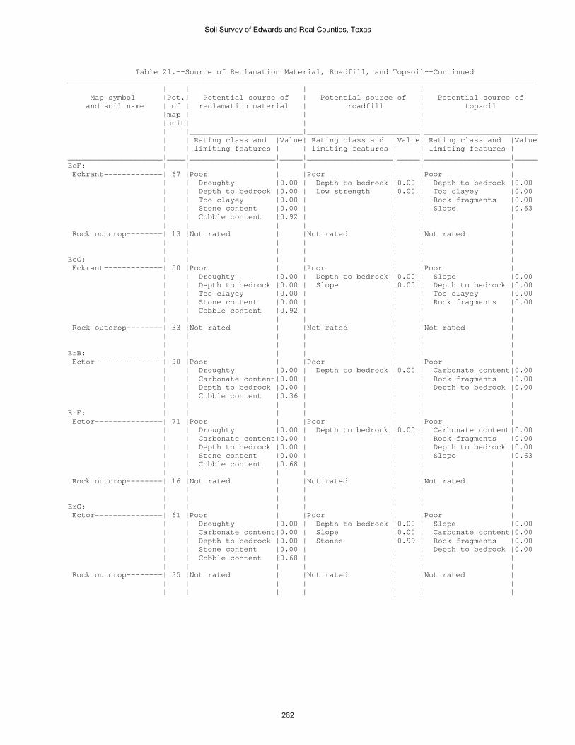
Table 21.--Source of Reclamation Material, Roadfill, and Topsoil--Continued ________________________________________________________________________________________________________ | | | | Map symbol |Pct.| Potential source of | Potential source of | Potential source of and soil name | of | reclamation material | roadfill | topsoil |map | | | |unit| | | | |_________________________|_________________________|_________________________ | | Rating class and |Value| Rating class and |Value| Rating class and |Value | | limiting features | | limiting features | | limiting features | _____________________|____|___________________|_____|___________________|_____|___________________|_____ EcF: | | | | | | | Eckrant-------------| 67 |Poor | |Poor | |Poor | | | Droughty |0.00 | Depth to bedrock |0.00 | Depth to bedrock |0.00 | | Depth to bedrock |0.00 | Low strength |0.00 | Too clayey |0.00 | | Too clayey |0.00 | | | Rock fragments |0.00 | | Stone content |0.00 | | | Slope |0.63 | | Cobble content |0.92 | | | | | | | | | | | Rock outcrop--------| 13 |Not rated | |Not rated | |Not rated | | | | | | | | | | | | | | | EcG: | | | | | | | Eckrant-------------| 50 |Poor | |Poor | |Poor | | | Droughty |0.00 | Depth to bedrock |0.00 | Slope |0.00 | | Depth to bedrock |0.00 | Slope |0.00 | Depth to bedrock |0.00 | | Too clayey |0.00 | | | Too clayey |0.00 | | Stone content |0.00 | | | Rock fragments |0.00 | | Cobble content |0.92 | | | | | | | | | | | Rock outcrop--------| 33 |Not rated | |Not rated | |Not rated | | | | | | | | | | | | | | | ErB: | | | | | | | Ector---------------| 90 |Poor | |Poor | |Poor | | | Droughty |0.00 | Depth to bedrock |0.00 | Carbonate content|0.00 | | Carbonate content|0.00 | | | Rock fragments |0.00 | | Depth to bedrock |0.00 | | | Depth to bedrock |0.00 | | Cobble content |0.36 | | | | | | | | | | | ErF: | | | | | | | Ector---------------| 71 |Poor | |Poor | |Poor | | | Droughty |0.00 | Depth to bedrock |0.00 | Carbonate content|0.00 | | Carbonate content|0.00 | | | Rock fragments |0.00 | | Depth to bedrock |0.00 | | | Depth to bedrock |0.00 | | Stone content |0.00 | | | Slope |0.63 | | Cobble content |0.68 | | | | | | | | | | | Rock outcrop--------| 16 |Not rated | |Not rated | |Not rated | | | | | | | | | | | | | | | ErG: | | | | | | | Ector---------------| 61 |Poor | |Poor | |Poor | | | Droughty |0.00 | Depth to bedrock |0.00 | Slope |0.00 | | Carbonate content|0.00 | Slope |0.00 | Carbonate content|0.00 | | Depth to bedrock |0.00 | Stones |0.99 | Rock fragments |0.00 | | Stone content |0.00 | | | Depth to bedrock |0.00 | | Cobble content |0.68 | | | | | | | | | | | Rock outcrop--------| 35 |Not rated | |Not rated | |Not rated | | | | | | | | | | | | | | |
Soil Survey of Edwards and Real Counties, Texas
262

Table 21.--Source of Reclamation Material, Roadfill, and Topsoil--Continued ________________________________________________________________________________________________________ | | | | Map symbol |Pct.| Potential source of | Potential source of | Potential source of and soil name | of | reclamation material | roadfill | topsoil |map | | | |unit| | | | |_________________________|_________________________|_________________________ | | Rating class and |Value| Rating class and |Value| Rating class and |Value | | limiting features | | limiting features | | limiting features | _____________________|____|___________________|_____|___________________|_____|___________________|_____ IrA: | | | | | | | Irion---------------| 90 |Poor | |Poor | |Poor | | | Too clayey |0.00 | Low strength |0.00 | Too clayey |0.00 | | | | Shrink-swell |0.12 | | | | | | | | | KrD: | | | | | | | Kerrville-----------| 54 |Poor | |Poor | |Poor | | | Carbonate content|0.00 | Depth to bedrock |0.00 | Carbonate content|0.00 | | Droughty |0.00 | | | Rock fragments |0.00 | | Organic matter |0.60 | | | Too clayey |0.61 | | content low | | | | | | | Depth to bedrock |0.79 | | | Depth to bedrock |0.79 | | Too clayey |0.92 | | | | | | | | | | | Real----------------| 26 |Poor | |Poor | |Poor | | | Droughty |0.00 | Depth to bedrock |0.00 | Carbonate content|0.00 | | Carbonate content|0.00 | | | Rock fragments |0.00 | | Depth to bedrock |0.00 | | | Depth to bedrock |0.00 | | Too clayey |0.98 | | | Too clayey |0.98 | | | | | | | KrF: | | | | | | | Kerrville-----------| 60 |Poor | |Poor | |Poor | | | Carbonate content|0.00 | Depth to bedrock |0.00 | Carbonate content|0.00 | | Droughty |0.06 | Slope |0.02 | Rock fragments |0.00 | | Organic matter |0.60 | | | Slope |0.00 | | content low | | | | | | | Too clayey |0.92 | | | Too clayey |0.61 | | Depth to bedrock |0.93 | | | Depth to bedrock |0.93 | | | | | | | Real----------------| 21 |Poor | |Poor | |Poor | | | Droughty |0.00 | Depth to bedrock |0.00 | Carbonate content|0.00 | | Carbonate content|0.00 | Slope |0.02 | Rock fragments |0.00 | | Depth to bedrock |0.00 | | | Depth to bedrock |0.00 | | Too clayey |0.98 | | | Slope |0.00 | | | | | | Too clayey |0.98 | | | | | | | LaE: | | | | | | | Langtry-------------| 72 |Poor | |Poor | |Poor | | | Droughty |0.00 | Depth to bedrock |0.00 | Carbonate content|0.00 | | Carbonate content|0.00 | Cobble content |0.88 | Rock fragments |0.00 | | Depth to bedrock |0.00 | | | Depth to bedrock |0.00 | | Cobble content |0.00 | | | | | | Stone content |0.82 | | | | | | | | | | | Rock outcrop--------| 10 |Not rated | |Not rated | |Not rated | | | | | | | | | | | | | | | LkB: | | | | | | | Leakey--------------| 73 |Poor | |Poor | |Poor | | | Too clayey |0.00 | Depth to cemented|0.00 | Too clayey |0.00 | | | | pan | | | | | Carbonate content|0.00 | Shrink-swell |0.00 | Depth to cemented|0.85 | | | | | | pan | | | Droughty |0.14 | Low strength |0.78 | Rock fragments |0.97 | | Depth to cemented|0.85 | | | | | | pan | | | | | | | Water erosion |0.90 | | | | | | | | | | |
Soil Survey of Edwards and Real Counties, Texas
263

Table 21.--Source of Reclamation Material, Roadfill, and Topsoil--Continued ________________________________________________________________________________________________________ | | | | Map symbol |Pct.| Potential source of | Potential source of | Potential source of and soil name | of | reclamation material | roadfill | topsoil |map | | | |unit| | | | |_________________________|_________________________|_________________________ | | Rating class and |Value| Rating class and |Value| Rating class and |Value | | limiting features | | limiting features | | limiting features | _____________________|____|___________________|_____|___________________|_____|___________________|_____ MaD: | | | | | | | Mailtrail-----------| 67 |Poor | |Poor | |Poor | | | Droughty |0.00 | Depth to cemented|0.00 | Rock fragments |0.00 | | | | pan | | | | | Carbonate content|0.00 | Stones |0.81 | Depth to cemented|0.00 | | | | | | pan | | | Depth to cemented|0.00 | Cobble content |0.99 | Carbonate content|0.00 | | pan | | | | | | | Stone content |0.00 | | | Too clayey |0.98 | | Cobble content |0.27 | | | | | | | | | | | MmC: | | | | | | | Mailtrail-----------| 55 |Poor | |Poor | |Poor | | | Droughty |0.00 | Depth to cemented|0.00 | Rock fragments |0.00 | | | | pan | | | | | Carbonate content|0.00 | Stones |0.92 | Depth to cemented|0.00 | | | | | | pan | | | Depth to cemented|0.00 | | | Carbonate content|0.00 | | pan | | | | | | | Stone content |0.00 | | | Too clayey |0.98 | | Cobble content |0.27 | | | | | | | | | | | Mereta--------------| 30 |Poor | |Poor | |Poor | | | Depth to cemented|0.00 | Depth to cemented|0.00 | Depth to cemented|0.00 | | pan | | pan | | pan | | | Droughty |0.05 | Low strength |0.00 | Too clayey |0.68 | | Carbonate content|0.46 | Shrink-swell |0.87 | | | | Too clayey |0.68 | | | | | | | | | | | NuB: | | | | | | | Nuvalde-------------| 90 |Poor | |Poor | |Fair | | | Carbonate content|0.00 | Low strength |0.00 | Too clayey |0.77 | | Organic matter |0.60 | Shrink-swell |0.66 | | | | content low | | | | | | | Too clayey |0.82 | | | | | | | | | | | OdA: | | | | | | | Oakalla, >27 PZ-----| 50 |Poor | |Poor | |Poor | | | Carbonate content|0.00 | Low strength |0.00 | Carbonate content|0.00 | | | | Shrink-swell |0.87 | | | | | | | | | Dev-----------------| 40 |Poor | |Fair | |Poor | | | Carbonate content|0.00 | Cobble content |0.96 | Rock fragments |0.00 | | Droughty |0.62 | | | Hard to reclaim |0.00 | | | | | | (rock fragments)| | | Organic matter |0.88 | | | Carbonate content|0.00 | | content low | | | | | | | | | | | | OrA: | | | | | | | Orif----------------| 95 |Poor | |Good | |Poor | | | Too sandy |0.00 | | | Too sandy |0.00 | | Carbonate content|0.00 | | | Hard to reclaim |0.00 | | | | | | (rock fragments)| | | Droughty |0.91 | | | Rock fragments |0.00 | | | | | | Carbonate content|0.00 | | | | | | |
Soil Survey of Edwards and Real Counties, Texas
264

Table 21.--Source of Reclamation Material, Roadfill, and Topsoil--Continued ________________________________________________________________________________________________________ | | | | Map symbol |Pct.| Potential source of | Potential source of | Potential source of and soil name | of | reclamation material | roadfill | topsoil |map | | | |unit| | | | |_________________________|_________________________|_________________________ | | Rating class and |Value| Rating class and |Value| Rating class and |Value | | limiting features | | limiting features | | limiting features | _____________________|____|___________________|_____|___________________|_____|___________________|_____ OrG: | | | | | | | Oplin---------------| 53 |Poor | |Poor | |Poor | | | Droughty |0.00 | Depth to bedrock |0.00 | Slope |0.00 | | Depth to bedrock |0.00 | Slope |0.00 | Depth to bedrock |0.00 | | Carbonate content|0.92 | | | Rock fragments |0.00 | | Cobble content |0.92 | | | Carbonate content|0.92 | | Stone content |0.92 | | | | | | | | | | | Rock outcrop--------| 30 |Not rated | |Not rated | |Not rated | | | | | | | | | | | | | | | PeB: | | | | | | | Prade---------------| 35 |Poor | |Poor | |Poor | | | Too clayey |0.00 | Depth to bedrock |0.00 | Too clayey |0.00 | | Droughty |0.00 | Depth to cemented|0.00 | Rock fragments |0.00 | | | | pan | | | | | Depth to cemented|0.00 | Low strength |0.00 | Depth to cemented|0.00 | | pan | | | | pan | | | Depth to bedrock |0.00 | Shrink-swell |0.87 | Depth to bedrock |0.00 | | Cobble content |0.16 | Cobble content |0.99 | | | | | | | | | Eckrant-------------| 28 |Poor | |Poor | |Poor | | | Droughty |0.00 | Depth to bedrock |0.00 | Depth to bedrock |0.00 | | Depth to bedrock |0.00 | Low strength |0.00 | Too clayey |0.00 | | Too clayey |0.00 | Shrink-swell |0.87 | Rock fragments |0.00 | | Stone content |0.00 | Stones |0.94 | | | | Cobble content |0.68 | | | | | | | | | | | PIT: | | | | | | | Pits----------------|100 |Not rated | |Not rated | |Not rated | | | | | | | | | | | | | | | PrC: | | | | | | | Prade---------------| 43 |Poor | |Poor | |Poor | | | Too clayey |0.00 | Depth to bedrock |0.00 | Too clayey |0.00 | | Droughty |0.00 | Depth to cemented|0.00 | Depth to cemented|0.00 | | | | pan | | pan | | | Depth to cemented|0.00 | Low strength |0.00 | Rock fragments |0.00 | | pan | | | | | | | Depth to bedrock |0.00 | Shrink-swell |0.87 | Depth to bedrock |0.00 | | Cobble content |0.16 | | | | | | | | | | | Tarrant, <31 PZ-----| 40 |Poor | |Poor | |Poor | | | Too clayey |0.00 | Depth to bedrock |0.00 | Too clayey |0.00 | | Droughty |0.00 | Low strength |0.00 | Rock fragments |0.00 | | Depth to bedrock |0.00 | Cobble content |0.37 | Depth to bedrock |0.00 | | Cobble content |0.00 | Shrink-swell |0.87 | Carbonate content|0.68 | | Carbonate content|0.68 | | | | | | | | | | | PtB: | | | | | | | Pratley-------------| 75 |Poor | |Poor | |Poor | | | Too clayey |0.00 | Depth to cemented|0.00 | Too clayey |0.00 | | | | pan | | | | | Depth to cemented|0.10 | Low strength |0.00 | Depth to cemented|0.10 | | pan | | | | pan | | | Droughty |0.21 | Depth to bedrock |0.00 | Depth to bedrock |0.54 | | Depth to bedrock |0.54 | Shrink-swell |0.37 | Rock fragments |0.73 | | | | | | |
Soil Survey of Edwards and Real Counties, Texas
265

Table 21.--Source of Reclamation Material, Roadfill, and Topsoil--Continued ________________________________________________________________________________________________________ | | | | Map symbol |Pct.| Potential source of | Potential source of | Potential source of and soil name | of | reclamation material | roadfill | topsoil |map | | | |unit| | | | |_________________________|_________________________|_________________________ | | Rating class and |Value| Rating class and |Value| Rating class and |Value | | limiting features | | limiting features | | limiting features | _____________________|____|___________________|_____|___________________|_____|___________________|_____ RaF: | | | | | | | Real----------------| 53 |Poor | |Poor | |Poor | | | Droughty |0.00 | Depth to bedrock |0.00 | Carbonate content|0.00 | | Carbonate content|0.00 | | | Rock fragments |0.00 | | Depth to bedrock |0.00 | | | Depth to bedrock |0.00 | | Too clayey |0.98 | | | Slope |0.63 | | | | | | Too clayey |0.98 | | | | | | | Oplin---------------| 24 |Poor | |Poor | |Poor | | | Droughty |0.00 | Depth to bedrock |0.00 | Depth to bedrock |0.00 | | Depth to bedrock |0.00 | | | Rock fragments |0.00 | | Carbonate content|0.92 | | | Carbonate content|0.92 | | Cobble content |0.92 | | | | | | Stone content |0.92 | | | | | | | | | | | RdB: | | | | | | | Rio Diablo----------| 85 |Poor | |Poor | |Poor | | | Carbonate content|0.00 | Low strength |0.00 | Too clayey |0.00 | | Too clayey |0.00 | Shrink-swell |0.87 | Carbonate content|0.24 | | | | | | Hard to reclaim |0.88 | | | | | | (rock fragments)| | | | | | | | RfB: | | | | | | | Rio Frio------------| 65 |Poor | |Poor | |Poor | | | Carbonate content|0.00 | Low strength |0.00 | Carbonate content|0.00 | | Organic matter |0.68 | Shrink-swell |0.87 | Rock fragments |0.97 | | content low | | | | | | | | | | | | Vanderpool----------| 20 |Poor | |Poor | |Poor | | | Carbonate content|0.00 | Low strength |0.00 | Carbonate content|0.00 | | Organic matter |0.60 | Shrink-swell |0.87 | Rock fragments |0.97 | | content low | | | | | | | | | | | | RsB: | | | | | | | Riverwash-----------| 75 |Poor | |Fair | |Poor | | | Droughty |0.00 | Cobble content |0.82 | Hard to reclaim |0.00 | | | | | | (rock fragments)| | | Organic matter |0.50 | Stones |0.82 | Rock fragments |0.00 | | content low | | | | | | | Stone content |0.82 | | | | | | | | | | | Dev-----------------| 15 |Poor | |Fair | |Poor | | | Carbonate content|0.00 | Cobble content |0.96 | Rock fragments |0.00 | | Droughty |0.62 | | | Hard to reclaim |0.00 | | | | | | (rock fragments)| | | Organic matter |0.88 | | | Carbonate content|0.00 | | content low | | | | | | | | | | | | RtG: | | | | | | | Rock outcrop--------| 55 |Not rated | |Not rated | |Not rated | | | | | | | | | | | | | | | Langtry-------------| 40 |Poor | |Poor | |Poor | | | Droughty |0.00 | Depth to bedrock |0.00 | Slope |0.00 | | Carbonate content|0.00 | Slope |0.00 | Carbonate content|0.00 | | Depth to bedrock |0.00 | Cobble content |0.76 | Rock fragments |0.00 | | Cobble content |0.00 | | | Depth to bedrock |0.00 | | Stone content |0.82 | | | Too clayey |0.92 | | | | | | |
Soil Survey of Edwards and Real Counties, Texas
266

Table 21.--Source of Reclamation Material, Roadfill, and Topsoil--Continued ________________________________________________________________________________________________________ | | | | Map symbol |Pct.| Potential source of | Potential source of | Potential source of and soil name | of | reclamation material | roadfill | topsoil |map | | | |unit| | | | |_________________________|_________________________|_________________________ | | Rating class and |Value| Rating class and |Value| Rating class and |Value | | limiting features | | limiting features | | limiting features | _____________________|____|___________________|_____|___________________|_____|___________________|_____ StC: | | | | | | | Spires--------------| 61 |Poor | |Poor | |Poor | | | Too clayey |0.00 | Low strength |0.00 | Too clayey |0.00 | | Droughty |0.05 | Depth to bedrock |0.00 | Depth to bedrock |0.35 | | Depth to bedrock |0.35 | Shrink-swell |0.12 | Rock fragments |0.95 | | | | | | | Tarpley-------------| 29 |Poor | |Poor | |Poor | | | Too clayey |0.00 | Depth to bedrock |0.00 | Too clayey |0.00 | | Droughty |0.00 | Shrink-swell |0.00 | Depth to bedrock |0.00 | | Depth to bedrock |0.00 | Low strength |0.00 | Rock fragments |0.88 | | | | | | | TeA: | | | | | | | Tarrant, <31 PZ-----| 35 |Poor | |Poor | |Poor | | | Too clayey |0.00 | Depth to bedrock |0.00 | Too clayey |0.00 | | Droughty |0.00 | Low strength |0.00 | Rock fragments |0.00 | | Depth to bedrock |0.00 | Cobble content |0.63 | Depth to bedrock |0.00 | | Cobble content |0.00 | Shrink-swell |0.87 | Carbonate content|0.68 | | Carbonate content|0.68 | | | | | | | | | | | Eckrant-------------| 30 |Poor | |Poor | |Poor | | | Too clayey |0.00 | Depth to bedrock |0.00 | Too clayey |0.00 | | Droughty |0.00 | Low strength |0.00 | Depth to bedrock |0.00 | | Depth to bedrock |0.00 | | | Rock fragments |0.00 | | Stone content |0.08 | | | | | | Cobble content |0.92 | | | | | | | | | | | TvB: | | | | | | | Tarrant, <31 PZ-----| 43 |Poor | |Poor | |Poor | | | Too clayey |0.00 | Depth to bedrock |0.00 | Too clayey |0.00 | | Droughty |0.00 | Low strength |0.00 | Rock fragments |0.00 | | Depth to bedrock |0.00 | Cobble content |0.83 | Depth to bedrock |0.00 | | Cobble content |0.00 | Shrink-swell |0.87 | Carbonate content|0.68 | | Carbonate content|0.68 | | | | | | | | | | | Valera--------------| 30 |Poor | |Poor | |Poor | | | Too clayey |0.00 | Depth to cemented|0.00 | Too clayey |0.00 | | | | pan | | | | | Depth to cemented|0.54 | Low strength |0.00 | Depth to cemented|0.54 | | pan | | | | pan | | | Depth to bedrock |0.71 | Depth to bedrock |0.00 | Depth to bedrock |0.71 | | Droughty |0.94 | Shrink-swell |0.12 | Rock fragments |0.97 | | Carbonate content|0.97 | | | | | | | | | | | VaA: | | | | | | | Valera--------------| 75 |Poor | |Poor | |Poor | | | Too clayey |0.00 | Depth to cemented|0.00 | Too clayey |0.00 | | | | pan | | | | | Depth to cemented|0.71 | Low strength |0.00 | Depth to cemented|0.71 | | pan | | | | pan | | | Depth to bedrock |0.90 | Depth to bedrock |0.00 | Depth to bedrock |0.90 | | Carbonate content|0.97 | Shrink-swell |0.12 | Rock fragments |0.97 | | Droughty |0.99 | | | | | | | | | | | W: | | | | | | | Water---------------|100 |Not rated | |Not rated | |Not rated | | | | | | | | | | | | | | | _____________________|____|___________________|_____|___________________|_____|___________________|_____
Soil Survey of Edwards and Real Counties, Texas
267

Table 22.--Ponds and Embankments (The information in this table indicates the dominant soil condition but does not eliminate the need for onsite investigation. The numbers in the value columns range from 0.01 to 1.00. The larger the value, the greater the limitation. See text for further explanation of ratings in this table.) ________________________________________________________________________________________________________ | | | | Map symbol |Pct.| Pond reservoir areas | Embankments, dikes, and | Aquifer-fed and soil name | of | | levees | excavated ponds |map | | | |unit| | | | |_________________________|_________________________|_________________________ | | Rating class and |Value| Rating class and |Value| Rating class and |Value | | limiting features | | limiting features | | limiting features | _____________________|____|___________________|_____|___________________|_____|___________________|_____ CkB: | | | | | | | Campwood------------| 53 |Not limited | |Somewhat limited | |Very limited | | | | | Hard to pack |0.91 | Depth to water |1.00 | | | | | | | Knippa, >27 PZ------| 30 |Somewhat limited | |Somewhat limited | |Very limited | | | Seepage |0.03 | Hard to pack |0.72 | Depth to water |1.00 | | | | | | | CoB: | | | | | | | Cho-----------------| 33 |Very limited | |Very limited | |Very limited | | | Depth to cemented|1.00 | Thin layer |1.00 | Depth to water |1.00 | | pan | | | | | | | Seepage |0.70 | Piping |0.05 | | | | | | | | | Angelo--------------| 29 |Somewhat limited | |Somewhat limited | |Very limited | | | Seepage |0.70 | Thin layer |0.01 | Depth to water |1.00 | | Depth to bedrock |0.01 | | | | | | | | | | | DeB: | | | | | | | Dev-----------------| 60 |Very limited | |Not limited | |Very limited | | | Seepage |1.00 | | | Depth to water |1.00 | | | | | | | Riverwash-----------| 25 |Very limited | |Not rated | |Very limited | | | Seepage |1.00 | | | Depth to water |1.00 | | Not rated |1.00 | | | | | | | | | | | DnD: | | | | | | | Dina----------------| 60 |Somewhat limited | |Very limited | |Very limited | | | Depth to bedrock |0.81 | Seepage |1.00 | Depth to water |1.00 | | Seepage |0.53 | Thin layer |0.81 | | | | | | Large stones |0.23 | | | | | | | | | Eckrant-------------| 30 |Very limited | |Very limited | |Very limited | | | Depth to bedrock |1.00 | Thin layer |1.00 | Depth to water |1.00 | | Seepage |0.45 | Large stones |1.00 | | | | Slope |0.32 | Hard to pack |0.80 | | | | | | | | | EcF: | | | | | | | Eckrant-------------| 67 |Very limited | |Very limited | |Very limited | | | Depth to bedrock |1.00 | Thin layer |1.00 | Depth to water |1.00 | | Slope |1.00 | Large stones |0.92 | | | | Seepage |0.45 | Hard to pack |0.68 | | | | | | | | | Rock outcrop--------| 13 |Very limited | |Not rated | |Not rated | | | Depth to bedrock |1.00 | | | | | | Not rated |1.00 | | | | | | Seepage |1.00 | | | | | | Slope |1.00 | | | | | | | | | | |
Soil Survey of Edwards and Real Counties, Texas
268

Table 22.--Ponds and Embankments--Continued ________________________________________________________________________________________________________ | | | | Map symbol |Pct.| Pond reservoir areas | Embankments, dikes, and | Aquifer-fed and soil name | of | | levees | excavated ponds |map | | | |unit| | | | |_________________________|_________________________|_________________________ | | Rating class and |Value| Rating class and |Value| Rating class and |Value | | limiting features | | limiting features | | limiting features | _____________________|____|___________________|_____|___________________|_____|___________________|_____ EcG: | | | | | | | Eckrant-------------| 50 |Very limited | |Not rated | |Very limited | | | Slope |1.00 | | | Depth to water |1.00 | | Depth to bedrock |1.00 | | | | | | Seepage |0.45 | | | | | | | | | | | Rock outcrop--------| 33 |Very limited | |Not rated | |Not rated | | | Slope |1.00 | | | | | | Depth to bedrock |1.00 | | | | | | Not rated |1.00 | | | | | | Seepage |1.00 | | | | | | | | | | | ErB: | | | | | | | Ector---------------| 90 |Very limited | |Very limited | |Very limited | | | Depth to bedrock |1.00 | Thin layer |1.00 | Depth to water |1.00 | | Seepage |0.45 | Large stones |0.88 | | | | | | | | | ErF: | | | | | | | Ector---------------| 71 |Very limited | |Very limited | |Very limited | | | Depth to bedrock |1.00 | Thin layer |1.00 | Depth to water |1.00 | | Slope |1.00 | Large stones |1.00 | | | | Seepage |0.45 | | | | | | | | | | | Rock outcrop--------| 16 |Very limited | |Not rated | |Not rated | | | Depth to bedrock |1.00 | | | | | | Not rated |1.00 | | | | | | Seepage |1.00 | | | | | | Slope |1.00 | | | | | | | | | | | ErG: | | | | | | | Ector---------------| 61 |Very limited | |Very limited | |Very limited | | | Slope |1.00 | Thin layer |1.00 | Depth to water |1.00 | | Depth to bedrock |1.00 | Large stones |1.00 | | | | Seepage |0.45 | | | | | | | | | | | Rock outcrop--------| 35 |Very limited | |Not rated | |Not rated | | | Slope |1.00 | | | | | | Depth to bedrock |1.00 | | | | | | Not rated |1.00 | | | | | | Seepage |1.00 | | | | | | | | | | | IrA: | | | | | | | Irion---------------| 90 |Not limited | |Very limited | |Very limited | | | | | Ponding |1.00 | Depth to water |1.00 | | | | Hard to pack |0.68 | | | | | | | | | KrD: | | | | | | | Kerrville-----------| 54 |Somewhat limited | |Somewhat limited | |Very limited | | | Depth to bedrock |0.77 | Seepage |0.90 | Depth to water |1.00 | | Seepage |0.70 | Thin layer |0.77 | | | | Slope |0.32 | | | | | | | | | | | Real----------------| 26 |Somewhat limited | |Very limited | |Very limited | | | Depth to bedrock |0.87 | Thin layer |1.00 | Depth to water |1.00 | | Seepage |0.53 | | | | | | Slope |0.32 | | | | | | | | | | |
Soil Survey of Edwards and Real Counties, Texas
269

Table 22.--Ponds and Embankments--Continued ________________________________________________________________________________________________________ | | | | Map symbol |Pct.| Pond reservoir areas | Embankments, dikes, and | Aquifer-fed and soil name | of | | levees | excavated ponds |map | | | |unit| | | | |_________________________|_________________________|_________________________ | | Rating class and |Value| Rating class and |Value| Rating class and |Value | | limiting features | | limiting features | | limiting features | _____________________|____|___________________|_____|___________________|_____|___________________|_____ KrF: | | | | | | | Kerrville-----------| 60 |Very limited | |Somewhat limited | |Very limited | | | Slope |1.00 | Thin layer |0.66 | Depth to water |1.00 | | Seepage |0.70 | | | | | | Depth to bedrock |0.66 | | | | | | | | | | | Real----------------| 21 |Very limited | |Very limited | |Very limited | | | Slope |1.00 | Thin layer |1.00 | Depth to water |1.00 | | Depth to bedrock |0.84 | | | | | | Seepage |0.53 | | | | | | | | | | | LaE: | | | | | | | Langtry-------------| 72 |Very limited | |Very limited | |Very limited | | | Depth to bedrock |1.00 | Thin layer |1.00 | Depth to water |1.00 | | Slope |1.00 | Large stones |1.00 | | | | Seepage |0.45 | Seepage |0.75 | | | | | | | | | Rock outcrop--------| 10 |Very limited | |Not rated | |Not rated | | | Depth to bedrock |1.00 | | | | | | Not rated |1.00 | | | | | | Seepage |1.00 | | | | | | Slope |1.00 | | | | | | | | | | | LkB: | | | | | | | Leakey--------------| 73 |Somewhat limited | |Somewhat limited | |Very limited | | | Depth to cemented|0.74 | Hard to pack |0.80 | Depth to water |1.00 | | pan | | | | | | | | | Thin layer |0.74 | | | | | | | | | MaD: | | | | | | | Mailtrail-----------| 67 |Very limited | |Very limited | |Very limited | | | Depth to cemented|1.00 | Seepage |1.00 | Depth to water |1.00 | | pan | | | | | | | Slope |0.32 | Thin layer |1.00 | | | | | | Large stones |1.00 | | | | | | | | | MmC: | | | | | | | Mailtrail-----------| 55 |Very limited | |Very limited | |Very limited | | | Depth to cemented|1.00 | Seepage |1.00 | Depth to water |1.00 | | pan | | | | | | | | | Thin layer |1.00 | | | | | | Large stones |1.00 | | | | | | | | | Mereta--------------| 30 |Very limited | |Very limited | |Very limited | | | Depth to cemented|1.00 | Seepage |1.00 | Depth to water |1.00 | | pan | | | | | | | Seepage |0.02 | Thin layer |1.00 | | | | | | | | | NuB: | | | | | | | Nuvalde-------------| 90 |Somewhat limited | |Not limited | |Very limited | | | Seepage |0.70 | | | Depth to water |1.00 | | | | | | | OdA: | | | | | | | Oakalla, >27 PZ-----| 50 |Somewhat limited | |Not limited | |Very limited | | | Seepage |0.70 | | | Depth to water |1.00 | | | | | | | Dev-----------------| 40 |Very limited | |Not limited | |Very limited | | | Seepage |1.00 | | | Depth to water |1.00 | | | | | | |
Soil Survey of Edwards and Real Counties, Texas
270
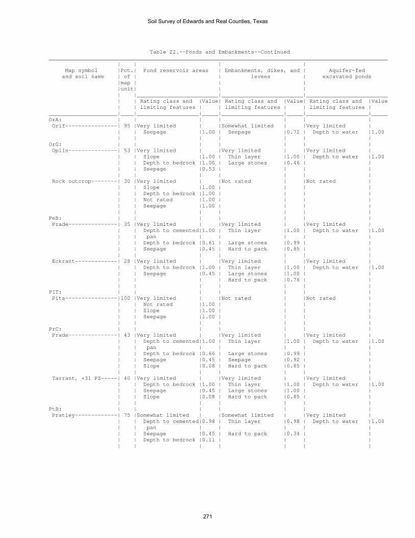
Table 22.--Ponds and Embankments--Continued ________________________________________________________________________________________________________ | | | | Map symbol |Pct.| Pond reservoir areas | Embankments, dikes, and | Aquifer-fed and soil name | of | | levees | excavated ponds |map | | | |unit| | | | |_________________________|_________________________|_________________________ | | Rating class and |Value| Rating class and |Value| Rating class and |Value | | limiting features | | limiting features | | limiting features | _____________________|____|___________________|_____|___________________|_____|___________________|_____ OrA: | | | | | | | Orif----------------| 95 |Very limited | |Somewhat limited | |Very limited | | | Seepage |1.00 | Seepage |0.72 | Depth to water |1.00 | | | | | | | OrG: | | | | | | | Oplin---------------| 53 |Very limited | |Very limited | |Very limited | | | Slope |1.00 | Thin layer |1.00 | Depth to water |1.00 | | Depth to bedrock |1.00 | Large stones |0.46 | | | | Seepage |0.53 | | | | | | | | | | | Rock outcrop--------| 30 |Very limited | |Not rated | |Not rated | | | Slope |1.00 | | | | | | Depth to bedrock |1.00 | | | | | | Not rated |1.00 | | | | | | Seepage |1.00 | | | | | | | | | | | PeB: | | | | | | | Prade---------------| 35 |Very limited | |Very limited | |Very limited | | | Depth to cemented|1.00 | Thin layer |1.00 | Depth to water |1.00 | | pan | | | | | | | Depth to bedrock |0.61 | Large stones |0.99 | | | | Seepage |0.45 | Hard to pack |0.85 | | | | | | | | | Eckrant-------------| 28 |Very limited | |Very limited | |Very limited | | | Depth to bedrock |1.00 | Thin layer |1.00 | Depth to water |1.00 | | Seepage |0.45 | Large stones |1.00 | | | | | | Hard to pack |0.76 | | | | | | | | | PIT: | | | | | | | Pits----------------|100 |Very limited | |Not rated | |Not rated | | | Not rated |1.00 | | | | | | Slope |1.00 | | | | | | Seepage |1.00 | | | | | | | | | | | PrC: | | | | | | | Prade---------------| 43 |Very limited | |Very limited | |Very limited | | | Depth to cemented|1.00 | Thin layer |1.00 | Depth to water |1.00 | | pan | | | | | | | Depth to bedrock |0.66 | Large stones |0.99 | | | | Seepage |0.45 | Seepage |0.92 | | | | Slope |0.08 | Hard to pack |0.85 | | | | | | | | | Tarrant, <31 PZ-----| 40 |Very limited | |Very limited | |Very limited | | | Depth to bedrock |1.00 | Thin layer |1.00 | Depth to water |1.00 | | Seepage |0.45 | Large stones |1.00 | | | | Slope |0.08 | Hard to pack |0.85 | | | | | | | | | PtB: | | | | | | | Pratley-------------| 75 |Somewhat limited | |Somewhat limited | |Very limited | | | Depth to cemented|0.98 | Thin layer |0.98 | Depth to water |1.00 | | pan | | | | | | | Seepage |0.45 | Hard to pack |0.34 | | | | Depth to bedrock |0.11 | | | | | | | | | | |
Soil Survey of Edwards and Real Counties, Texas
271

Table 22.--Ponds and Embankments--Continued ________________________________________________________________________________________________________ | | | | Map symbol |Pct.| Pond reservoir areas | Embankments, dikes, and | Aquifer-fed and soil name | of | | levees | excavated ponds |map | | | |unit| | | | |_________________________|_________________________|_________________________ | | Rating class and |Value| Rating class and |Value| Rating class and |Value | | limiting features | | limiting features | | limiting features | _____________________|____|___________________|_____|___________________|_____|___________________|_____ RaF: | | | | | | | Real----------------| 53 |Very limited | |Very limited | |Very limited | | | Slope |1.00 | Thin layer |1.00 | Depth to water |1.00 | | Depth to bedrock |0.74 | | | | | | Seepage |0.53 | | | | | | | | | | | Oplin---------------| 24 |Very limited | |Very limited | |Very limited | | | Depth to bedrock |1.00 | Thin layer |1.00 | Depth to water |1.00 | | Slope |0.68 | Large stones |0.46 | | | | Seepage |0.53 | | | | | | | | | | | RdB: | | | | | | | Rio Diablo----------| 85 |Somewhat limited | |Not limited | |Very limited | | | Seepage |0.03 | | | Depth to water |1.00 | | | | | | | RfB: | | | | | | | Rio Frio------------| 65 |Somewhat limited | |Somewhat limited | |Very limited | | | Seepage |0.70 | Piping |0.12 | Depth to water |1.00 | | | | | | | Vanderpool----------| 20 |Somewhat limited | |Somewhat limited | |Very limited | | | Seepage |0.70 | Piping |0.15 | Depth to water |1.00 | | | | | | | RsB: | | | | | | | Riverwash-----------| 75 |Very limited | |Not rated | |Very limited | | | Seepage |1.00 | | | Depth to water |1.00 | | Not rated |1.00 | | | | | | | | | | | Dev-----------------| 15 |Very limited | |Not limited | |Very limited | | | Seepage |1.00 | | | Depth to water |1.00 RtG: | | | | | | | Rock outcrop--------| 55 |Very limited | |Not rated | |Not rated | | | Slope |1.00 | | | | | | Depth to bedrock |1.00 | | | | | | Not rated |1.00 | | | | | | Seepage |1.00 | | | | | | | | | | | Langtry-------------| 40 |Very limited | |Very limited | |Very limited | | | Slope |1.00 | Thin layer |1.00 | Depth to water |1.00 | | Depth to bedrock |1.00 | Large stones |1.00 | | | | Seepage |0.45 | Seepage |0.75 | | StC: | | | | | | | Spires--------------| 61 |Somewhat limited | |Somewhat limited | |Very limited | | | Depth to bedrock |0.91 | Thin layer |0.91 | Depth to water |1.00 | | Seepage |0.53 | Hard to pack |0.81 | | | | | | | | | Tarpley-------------| 29 |Very limited | |Very limited | |Very limited | | | Depth to bedrock |1.00 | Thin layer |1.00 | Depth to water |1.00 | | Seepage |0.53 | Hard to pack |0.96 | | | | | | | | | TeA: | | | | | | | Tarrant, <31 PZ-----| 35 |Very limited | |Very limited | |Very limited | | | Depth to bedrock |1.00 | Thin layer |1.00 | Depth to water |1.00 | | Seepage |0.45 | Large stones |1.00 | | | | | | Hard to pack |0.85 | | | | | | | | | Eckrant-------------| 30 |Very limited | |Very limited | |Very limited | | | Depth to bedrock |1.00 | Thin layer |1.00 | Depth to water |1.00 | | Seepage |0.45 | Hard to pack |0.88 | | | | | | Large stones |0.84 | | | | | | | | |
Soil Survey of Edwards and Real Counties, Texas
272

Table 22.--Ponds and Embankments--Continued ________________________________________________________________________________________________________ | | | | Map symbol |Pct.| Pond reservoir areas | Embankments, dikes, and | Aquifer-fed and soil name | of | | levees | excavated ponds |map | | | |unit| | | | |_________________________|_________________________|_________________________ | | Rating class and |Value| Rating class and |Value| Rating class and |Value | | limiting features | | limiting features | | limiting features | _____________________|____|___________________|_____|___________________|_____|___________________|_____ | | | | | | | TvB: | | | | | | | Tarrant, <31 PZ-----| 43 |Very limited | |Very limited | |Very limited | | | Depth to bedrock |1.00 | Thin layer |1.00 | Depth to water |1.00 | | Seepage |0.45 | Large stones |1.00 | | | | | | Hard to pack |0.85 | | | | | | | | | Valera--------------| 30 |Somewhat limited | |Somewhat limited | |Very limited | | | Depth to cemented|0.86 | Thin layer |0.86 | Depth to water |1.00 | | pan | | | | | | | Depth to bedrock |0.81 | Hard to pack |0.41 | | | | Seepage |0.53 | | | | | | | | | | | VaA: | | | | | | | Valera--------------| 75 |Somewhat limited | |Somewhat limited | |Very limited | | | Depth to cemented|0.81 | Thin layer |0.81 | Depth to water |1.00 | | pan | | | | | | | Depth to bedrock |0.69 | Hard to pack |0.41 | | | | Seepage |0.53 | | | | | | | | | | | W: | | | | | | | Water---------------|100 |Not rated | |Not rated | |Not rated | | | | | | | | _____________________|____|___________________|_____|___________________|_____|___________________|_____
Soil Survey of Edwards and Real Counties, Texas
273
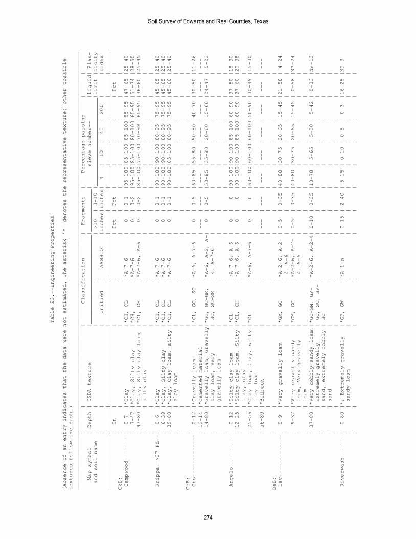
Table 23.--Engineering Properties
(Absence of an entry indicates that the data were not estimated. The asterisk '*' denotes the representative texture; other possible
textures follow the dash.)
______________________________________________________________________________________________________________________________________
| | | Classification | Fragments | Percentage passing | |
Map symbol | Depth | USDA texture |___________________________|_____________| sieve number-- |Liquid| Plas-
and soil name | | | | | >10 | 3-10 |___________________________|limit |ticity
| | | Unified | AASHTO |inches|inches| 4 | 10 | 40 | 200 | |index
_________________|_______|________________________|_____________|_____________|______|______|______|______|______|______|______|______
| In | | | | Pct | Pct | | | | | Pct |
CkB: | | | | | | | | | | | |
Campwood--------| 0-7 |*Clay |*CH, CL |*A-7-6 | 0 | 0-1 |95-100|85-100|85-100|85-95 |47-65 |25-40
| 7-47 |*Clay, Silty clay |*CH, |*A-7-6 | 0 | 0-2 |95-100|85-100|80-100|65-95 |51-74 |28-50
| 47-80 |*Clay, Silty clay loam, |*CL, CH |*A-7-6, A-6 | 0 | 0-2 |85-100|75-100|70-99 |65-95 |36-60 |25-45
| | silty clay | | | | | | | | | |
| | | | | | | | | | | |
Knippa, >27 PZ--| 0-6 |*Clay |*CH, CL |*A-7-6 | 0 | 0-1 |90-100|90-100|80-95 |75-95 |45-65 |25-40
| 6-39 |*Clay, Silty clay |*CH, CL |*A-7-6 | 0 | 0-1 |90-100|90-100|80-95 |75-95 |45-65 |25-40
| 39-80 |*Clay, Clay loam, silty |*CH, CL |*A-7-6 | 0 | 0-1 |90-100|85-100|80-95 |75-95 |45-60 |25-40
| | clay loam | | | | | | | | | |
| | | | | | | | | | | |
CoB: | | | | | | | | | | | |
Cho-------------| 0-12 |*Gravelly loam |*CL, GC, SC |*A-6, A-7-6 | 0 | 0-5 |60-85 |55-80 |50-80 |40-70 |30-50 |11-26
| 12-14 |*Cemented material | | | --- | --- | --- | --- | --- | --- | --- | ---
| 14-80 |*Gravelly loam, Gravelly|*GC, GC-GM, |*A-6, A-2, A-| 0 | 0-5 |50-85 |35-80 |20-60 |15-60 |24-47 | 5-22
| | clay loam, very | SC, SC-SM | 4, A-7-6 | | | | | | | |
| | gravelly loam | | | | | | | | | |
| | | | | | | | | | | |
Angelo----------| 0-12 |*Silty clay loam |*CL |*A-7-6, A-6 | 0 | 0 |90-100|90-100|85-100|60-90 |37-50 |18-30
| 12-25 |*Silty clay loam, Silty |*CL, CH |*A-7-6, A-6 | 0 | 0 |90-100|90-100|85-100|60-90 |37-60 |20-38
| | clay, clay | | | | | | | | | |
| 25-56 |*Clay loam, Clay, silty |*CL |*A-6, A-7-6 | 0 | 0 |60-100|60-100|60-100|50-90 |30-49 |15-30
| | clay loam | | | | | | | | | |
| 56-80 |*Bedrock | | | --- | --- | --- | --- | --- | --- | --- | ---
| | | | | | | | | | | |
DeB: | | | | | | | | | | | |
Dev-------------| 0-9 |*Very gravelly loam |*GM, GC |*A-2-6, A-2- | 0-5 | 0-35 |40-80 |30-75 |20-65 |15-45 |21-58 | 4-24
| | | | 4, A-6 | | | | | | | |
| 9-37 |*Very gravelly sandy |*GM, GC |*A-2-6, A-2- | 0-5 | 0-35 |40-80 |30-75 |20-65 |15-45 | 0-58 |NP-24
| | loam, Very gravelly | | 4, A-6 | | | | | | | |
| | loam | | | | | | | | | |
| 37-80 |*Very cobbly sandy loam,|*GC-GM, GP- |*A-2-6, A-2-4| 0-10 | 0-35 |10-78 | 5-65 | 5-50 | 5-42 | 0-33 |NP-13
| | Extremely gravelly | GC, SC, SP- | | | | | | | | |
| | sand, extremely cobbly | SC | | | | | | | | |
| | sand | | | | | | | | | |
| | | | | | | | | | | |
Riverwash-------| 0-80 |*, Extremely gravelly |*GP, GW |*A-1-a | 0-15 | 2-40 | 5-15 | 0-10 | 0-5 | 0-3 |16-25 |NP-3
| | sandy loam | | | | | | | | | |
| | | | | | | | | | | |
Soil Survey of Edwards and Real Counties, Texas
274

Table 23.--Engineering Properties--Continued
______________________________________________________________________________________________________________________________________
| | | Classification | Fragments | Percentage passing | |
Map symbol | Depth | USDA texture |___________________________|_____________| sieve number-- |Liquid| Plas-
and soil name | | | | | >10 | 3-10 |___________________________|limit |ticity
| | | Unified | AASHTO |inches|inches| 4 | 10 | 40 | 200 | |index
_________________|_______|________________________|_____________|_____________|______|______|______|______|______|______|______|______
| In | | | | Pct | Pct | | | | | Pct |
DnD: | | | | | | | | | | | |
Dina------------| 0-8 |*Cobbly silty clay loam |*GC, CL, SC |*A-6, A-2-6, | 0-15 | 0-30 |40-95 |35-95 |30-75 |26-55 |30-45 |11-25
| | | | A-2-7 | | | | | | | |
| 8-32 |*Very stony clay, |*GC, GP-GC, |*A-2-7, A-2-6| 0-20 | 3-50 |15-70 | 5-50 | 5-45 | 5-35 |38-75 |18-45
| | Extremely cobbly clay, | SC, SP-SC | | | | | | | | |
| | gravelly clay, very | | | | | | | | | |
| | cobbly clay | | | | | | | | | |
| 32-80 |*Bedrock | | | --- | --- | --- | --- | --- | --- | --- | ---
| | | | | | | | | | | |
Eckrant---------| 0-7 |*Very cobbly silty clay |*CH, CL, GC, |*A-7-6 | 0-30 |10-50 |70-95 |50-95 |45-95 |45-94 |41-60 |24-40
| | | SC | | | | | | | | |
| 7-16 |*Extremely stony silty |*CH, CL, GC, |*A-7-6 | 0-75 |15-75 |56-85 |50-79 |45-75 |44-74 |47-73 |25-45
| | clay, Very cobbly clay,| SC | | | | | | | | |
| | very stony clay | | | | | | | | | |
| 16-80 |*Bedrock | | | --- | --- | --- | --- | --- | --- | --- | ---
| | | | | | | | | | | |
EcF: | | | | | | | | | | | |
Eckrant---------| 0-9 |*Very cobbly silty clay |*CH, CL, GC, |*A-7-6 | 0-30 |10-50 |70-95 |50-95 |45-95 |45-94 |41-60 |24-40
| | | SC | | | | | | | | |
| 9-80 |*Bedrock | | | --- | --- | --- | --- | --- | --- | --- | ---
| | | | | | | | | | | |
Rock outcrop----| 0-80 |*Bedrock | | | --- | --- | --- | --- | --- | --- | --- | ---
| | | | | | | | | | | |
EcG: | | | | | | | | | | | |
Eckrant---------| 0-11 |*Very cobbly silty clay |*CH, CL, GC, |*A-7-6 | 0-30 |10-50 |70-95 |50-95 |45-95 |45-94 |41-60 |24-40
| | | SC | | | | | | | | |
| 11-80 |*Bedrock | | | --- | --- | --- | --- | --- | --- | --- | ---
| | | | | | | | | | | |
Rock outcrop----| 0-80 |*Bedrock | | | --- | --- | --- | --- | --- | --- | --- | ---
| | | | | | | | | | | |
ErB: | | | | | | | | | | | |
Ector-----------| 0-3 |*Gravelly silty clay |*GC, CL, CL- |*A-6, A-2, A-| 0 | 5-15 |50-75 |40-75 |35-70 |30-60 |20-40 | 5-22
| | loam | ML, SC | 4 | | | | | | | |
| 3-7 |*Extremely gravelly |*GC, GC-GM, |*A-2-6, A-1- | 5-10 |50-75 |25-55 |15-50 |15-50 |10-40 |20-40 | 5-22
| | silty clay loam, Very | GP-GC | a, A-2, A-4,| | | | | | | |
| | cobbly loam, extremely | | A-6 | | | | | | | |
| | cobbly loam, extremely | | | | | | | | | |
| | cobbly clay loam | | | | | | | | | |
| 7-80 |*Bedrock | | | --- | --- | --- | --- | --- | --- | --- | ---
| | | | | | | | | | | |
Soil Survey of Edwards and Real Counties, Texas
275

Table 23.--Engineering Properties--Continued
______________________________________________________________________________________________________________________________________
| | | Classification | Fragments | Percentage passing | |
Map symbol | Depth | USDA texture |___________________________|_____________| sieve number-- |Liquid| Plas-
and soil name | | | | | >10 | 3-10 |___________________________|limit |ticity
| | | Unified | AASHTO |inches|inches| 4 | 10 | 40 | 200 | |index
_________________|_______|________________________|_____________|_____________|______|______|______|______|______|______|______|______
| In | | | | Pct | Pct | | | | | Pct |
ErF: | | | | | | | | | | | |
Ector-----------| 0-8 |*Very cobbly loam |*GC, CL, SC |*A-6, A-2, A-| 5-30 |20-50 |40-75 |40-65 |35-60 |30-55 |30-44 |11-22
| | | | 7 | | | | | | | |
| 8-80 |*Bedrock | | | --- | --- | --- | --- | --- | --- | --- | ---
| | | | | | | | | | | |
Rock outcrop----| 0-80 |*Bedrock | | | --- | --- | --- | --- | --- | --- | --- | ---
| | | | | | | | | | | |
ErG: | | | | | | | | | | | |
Ector-----------| 0-12 |*Very cobbly loam |*GC, CL, SC |*A-6, A-2, A-| 5-30 |20-50 |40-75 |40-65 |35-60 |30-55 |30-44 |11-22
| | | | 7 | | | | | | | |
| 12-80 |*Bedrock | | | --- | --- | --- | --- | --- | --- | --- | ---
| | | | | | | | | | | |
Rock outcrop----| 0-80 |*Bedrock | | | --- | --- | --- | --- | --- | --- | --- | ---
| | | | | | | | | | | |
IrA: | | | | | | | | | | | |
Irion-----------| 0-14 |*Clay |*CH |*A-7-6 | 0 | 0-1 |95-100|95-100|90-100|75-80 |50-64 |27-37
| 14-54 |*Clay, Silty clay |*CH |*A-7-6 | 0 | 0-1 |95-100|95-100|90-100|75-90 |50-64 |27-37
| 54-72 |*Clay, Silty clay |*CH |*A-7-6 | 0-1 | 0-1 |95-100|95-100|90-100|75-90 |50-64 |27-37
| 72-80 |*Bedrock | | | 0 | 0 | --- | --- | --- | --- | --- | ---
| | | | | | | | | | | |
KrD: | | | | | | | | | | | |
Kerrville-------| 0-5 |*Gravelly silt loam |*CL, |*A-6, A-7-6 | 0-5 | 0-5 |90-100|75-90 |65-90 |55-80 |25-43 |10-26
| 5-33 |*Very paracobbly clay |*GC, GP-GC |*A-2-6 | 2-10 | 2-15 |15-60 |10-50 | 8-45 | 7-35 |22-38 |10-22
| | loam, Very paragravelly| | | | | | | | | |
| | silty clay loam, very | | | | | | | | | |
| | paragravelly clay loam,| | | | | | | | | |
| | very paraflaggy loam | | | | | | | | | |
| 33-48 |*Bedrock | | | --- | --- | --- | --- | --- | --- | --- | ---
| | | | | | | | | | | |
Real------------| 0-6 |*Very cobbly clay loam |*GC, GM, SC, |*A-2-7, A-2, | 0-3 | 0-15 |35-85 |30-50 |20-45 |20-40 |30-55 | 8-25
| | | SM | A-4, A-6, A-| | | | | | | |
| | | | 7 | | | | | | | |
| 6-9 |*Extremely cobbly clay |*GC, GM, SC, |*A-2-7, A-2, | 0-3 | 0-15 |25-75 |20-50 |20-45 |20-40 |30-55 | 8-25
| | loam, Very gravelly | SM | A-4, A-6, A-| | | | | | | |
| | clay loam, extremely | | 7 | | | | | | | |
| | gravelly clay loam, | | | | | | | | | |
| | extremely gravelly loam| | | | | | | | | |
| 9-80 |*Bedrock | | | --- | --- | --- | --- | --- | --- | --- | ---
| | | | | | | | | | | |
Soil Survey of Edwards and Real Counties, Texas
276

Table 23.--Engineering Properties--Continued
______________________________________________________________________________________________________________________________________
| | | Classification | Fragments | Percentage passing | |
Map symbol | Depth | USDA texture |___________________________|_____________| sieve number-- |Liquid| Plas-
and soil name | | | | | >10 | 3-10 |___________________________|limit |ticity
| | | Unified | AASHTO |inches|inches| 4 | 10 | 40 | 200 | |index
_________________|_______|________________________|_____________|_____________|______|______|______|______|______|______|______|______
| In | | | | Pct | Pct | | | | | Pct |
KrF: | | | | | | | | | | | |
Kerrville-------| 0-6 |*Gravelly silt loam |*CL |*A-6, A-7-6 | 0-5 | 0-5 |90-100|75-90 |65-90 |55-80 |25-43 |10-26
| 6-19 |*Very paragravelly silty|*CL, GC, SC |*A-6 | 0-5 | 0-10 |70-99 |60-85 |50-80 |45-72 |25-40 |10-23
| | clay loam, Clay loam, | | | | | | | | | |
| | gravelly loam | | | | | | | | | |
| 19-36 |*Very paragravelly silty|*GC, GP-GC |*A-2-6 | 2-10 | 2-15 |15-60 |10-50 | 8-45 | 7-35 |22-38 |10-22
| | clay loam, Very | | | | | | | | | |
| | paragravelly clay loam,| | | | | | | | | |
| | very paracobbly clay | | | | | | | | | |
| | loam, very paraflaggy | | | | | | | | | |
| | loam | | | | | | | | | |
| 36-48 |*Bedrock | | | --- | --- | --- | --- | --- | --- | --- | ---
| | | | | | | | | | | |
Real------------| 0-10 |*Very cobbly clay loam |*GC, GM, SC, |*A-2-7, A-2, | 0-3 | 0-15 |35-85 |30-50 |20-45 |20-40 |30-55 | 8-25
| | | SM | A-4, A-6, A-| | | | | | | |
| | | | 7 | | | | | | | |
| 10-80 |*Bedrock | | | --- | --- | --- | --- | --- | --- | --- | ---
| | | | | | | | | | | |
LaE: | | | | | | | | | | | |
Langtry---------| 0-8 |*Very cobbly silt loam |*GC, GP-GC, |*A-2-6, A-2-4| 0-15 |35-75 |20-40 |10-40 |10-40 |10-35 |25-35 | 8-15
| | | GW-GC | | | | | | | | |
| 8-13 |*Extremely cobbly silt |*GC, GP-GC |*A-2-6, A-2-4| 0-15 |50-85 |20-40 |10-40 |10-40 |10-35 |25-35 | 8-15
| | loam, Very cobbly silt | | | | | | | | | |
| | loam, extremely cobbly | | | | | | | | | |
| | clay loam | | | | | | | | | |
| 13-80 |*Bedrock | | | --- | --- | --- | --- | --- | --- | --- | ---
| | | | | | | | | | | |
Rock outcrop----| 0-80 |*Bedrock | | | --- | --- | --- | --- | --- | --- | --- | ---
| | | | | | | | | | | |
LkB: | | | | | | | | | | | |
Leakey----------| 0-8 |*Silty clay loam |*CL, CH |*A-7-6 | 0-1 | 0-5 |85-100|75-100|75-95 |75-90 |41-55 |25-35
| 8-21 |*Clay |*CH, |*A-7-6 | 0-1 | 0-5 |85-100|75-100|75-95 |70-95 |60-75 |33-47
| 21-34 |*Clay, Gravelly clay, |*GC, CH, SC |*A-7-6, A-2-7| 0-5 | 0-20 |35-95 |25-90 |25-80 |25-55 |51-70 |30-44
| | very gravelly clay | | | | | | | | | |
| 34-60 |*Cemented material | | | --- | --- | --- | --- | --- | --- | --- | ---
| | | | | | | | | | | |
Soil Survey of Edwards and Real Counties, Texas
277

Table 23.--Engineering Properties--Continued
______________________________________________________________________________________________________________________________________
| | | Classification | Fragments | Percentage passing | |
Map symbol | Depth | USDA texture |___________________________|_____________| sieve number-- |Liquid| Plas-
and soil name | | | | | >10 | 3-10 |___________________________|limit |ticity
| | | Unified | AASHTO |inches|inches| 4 | 10 | 40 | 200 | |index
_________________|_______|________________________|_____________|_____________|______|______|______|______|______|______|______|______
| In | | | | Pct | Pct | | | | | Pct |
MaD: | | | | | | | | | | | |
Mailtrail-------| 0-6 |*Very gravelly clay loam|*GC, GC-GM, |*A-2-6, A-2- | 0-15 | 2-35 |35-75 |25-55 |25-55 |20-50 |20-35 | 7-20
| | | SC, SC-SM | 4, A-4 | | | | | | | |
| 6-15 |*Extremely stony clay |*GC, GC-GM, |*A-2-6, A-2-4| 0-60 |30-80 |20-60 |15-40 |10-30 |10-25 |20-35 | 7-20
| | loam, Extremely cobbly | GP-GC | | | | | | | | |
| | clay loam, extremely | | | | | | | | | |
| | cobbly loam, extremely | | | | | | | | | |
| | gravelly clay loam | | | | | | | | | |
| 15-80 |*Cemented material | | | --- | --- | --- | --- | --- | --- | --- | ---
| | | | | | | | | | | |
MmC: | | | | | | | | | | | |
Mailtrail-------| 0-5 |*Very gravelly clay loam|*GC, GC-GM, |*A-2-6, A-2- | 0-15 | 2-35 |35-75 |25-55 |25-55 |20-50 |20-35 | 7-20
| | | SC, SC-SM | 4, A-4 | | | | | | | |
| 5-13 |*Extremely cobbly clay |*GC, GC-GM, |*A-2-6, A-2-4| 0-60 |30-80 |20-60 |15-40 |10-30 |10-25 |20-35 | 7-20
| | loam, Extremely stony | GP-GC | | | | | | | | |
| | clay loam, extremely | | | | | | | | | |
| | cobbly loam, extremely | | | | | | | | | |
| | gravelly clay loam | | | | | | | | | |
| 13-80 |*Cemented material | | | --- | --- | --- | --- | --- | --- | --- | ---
| | | | | | | | | | | |
Mereta----------| 0-12 |*Clay loam |*CL |*A-7-6, A-6 | 0 | 0-5 |90-100|85-100|80-97 |60-85 |39-50 |19-28
| 12-19 |*Clay loam, Clay, silty |*CL, CH |*A-7-6, A-6 | 0-2 | 0-5 |90-100|85-100|80-97 |60-85 |39-52 |19-30
| | clay | | | | | | | | | |
| 19-80 |*Cemented material | | | --- | --- | --- | --- | --- | --- | --- | ---
NuB: | | | | | | | | | | | |
Nuvalde---------| 0-18 |*Clay loam |*CL, CH |*A-7-6, A-6 | 0 | 0 |95-100|95-100|90-99 |80-96 |38-60 |20-38
| 18-26 |*Clay loam, Silty clay |*CL, CH |*A-7-6, A-6 | 0 | 0 |95-100|95-100|85-100|70-98 |38-58 |20-36
| | loam, clay | | | | | | | | | |
| 26-80 |*Clay loam, Loam, silty |*CL |*A-6, A-7-6 | 0 | 0 |85-100|85-100|75-98 |65-90 |30-50 |14-30
| | clay loam | | | | | | | | | |
| | | | | | | | | | | |
Soil Survey of Edwards and Real Counties, Texas
278

Table 23.--Engineering Properties--Continued
______________________________________________________________________________________________________________________________________
| | | Classification | Fragments | Percentage passing | |
Map symbol | Depth | USDA texture |___________________________|_____________| sieve number-- |Liquid| Plas-
and soil name | | | | | >10 | 3-10 |___________________________|limit |ticity
| | | Unified | AASHTO |inches|inches| 4 | 10 | 40 | 200 | |index
_________________|_______|________________________|_____________|_____________|______|______|______|______|______|______|______|______
| In | | | | Pct | Pct | | | | | Pct |
OdA: | | | | | | | | | | | |
Oakalla, >27 PZ-| 0-11 |*Clay loam |*CL, CH |*A-6, A-7-6 | 0-1 | 0-2 |90-100|90-100|85-100|60-97 |25-54 |14-33
| 11-27 |*Clay loam, Loam, silty |*CL, CH |*A-7-6, A-6 | 0-1 | 0-2 |85-100|80-100|70-100|60-99 |28-58 |13-38
| | clay loam | | | | | | | | | |
| 27-80 |*Clay loam, Loam, silty |*CH, CL |*A-6, A-4, A-| 0-1 | 0-2 |85-100|80-100|75-100|60-96 |25-55 | 8-35
| | clay loam | | 7-6 | | | | | | | |
| | | | | | | | | | | |
Dev-------------| 0-9 |*Very gravelly loam |*GM, GC |*A-2-6, A-2- | 0-5 | 0-35 |40-80 |30-75 |20-65 |15-45 |21-58 | 4-24
| | | | 4, A-6 | | | | | | | |
| 9-37 |*Very gravelly sandy |*GM, GC |*A-2-6, A-2- | 0-5 | 0-35 |40-80 |30-75 |20-65 |15-45 | 0-58 |NP-24
| | loam, Very gravelly | | 4, A-6 | | | | | | | |
| | loam | | | | | | | | | |
| 37-80 |*Very cobbly sandy loam,|*GC-GM, GP- |*A-2-6, A-2-4| 0-10 | 0-35 |10-78 | 5-65 | 5-50 | 5-42 | 0-33 |NP-13
| | Extremely gravelly | GC, SC, SP- | | | | | | | | |
| | sand, extremely cobbly | SC | | | | | | | | |
| | sand | | | | | | | | | |
| | | | | | | | | | | |
OrA: | | | | | | | | | | | |
Orif------------| 0-12 |*Fine sandy loam |*SC-SM, SC, |*A-2-4, A-1- | 0-10 | 0-10 |80-95 |75-95 |40-60 |20-40 | 0-30 |NP-10
| | | SM | b, A-4 | | | | | | | |
| 12-40 |*Extremely gravelly sand|*GM, GW-GM, |*A-1-a, A-1-b| 0-10 | 0-25 |11-60 | 5-50 | 5-35 | 5-20 | 0-20 |NP-4
| | | SM, SW-SM | | | | | | | | |
| 40-80 |*Coarse sand |*GM, GW-GM, |*A-1-a, A-1-b| 0-10 | 0-25 |11-60 | 5-50 | 5-35 | 5-20 | 0-20 |NP-4
| | | SM, SW-SM | | | | | | | | |
| | | | | | | | | | | |
OrG: | | | | | | | | | | | |
Oplin-----------| 0-8 |*Extremely cobbly clay |*GM, CL, GC, |*A-7-6, A-2, | 0-15 |15-45 |40-75 |35-75 |30-65 |25-60 |30-56 | 8-25
| | loam | ML | A-4, A-6, A-| | | | | | | |
| | | | 7 | | | | | | | |
| 8-80 |*Bedrock | | | --- | --- | --- | --- | --- | --- | --- | ---
| | | | | | | | | | | |
Rock outcrop----| 0-80 |*Bedrock | | | --- | --- | --- | --- | --- | --- | --- | ---
| | | | | | | | | | | |
Soil Survey of Edwards and Real Counties, Texas
279

Table 23.--Engineering Properties--Continued
______________________________________________________________________________________________________________________________________
| | | Classification | Fragments | Percentage passing | |
Map symbol | Depth | USDA texture |___________________________|_____________| sieve number-- |Liquid| Plas-
and soil name | | | | | >10 | 3-10 |___________________________|limit |ticity
| | | Unified | AASHTO |inches|inches| 4 | 10 | 40 | 200 | |index
_________________|_______|________________________|_____________|_____________|______|______|______|______|______|______|______|______
| In | | | | Pct | Pct | | | | | Pct |
PeB: | | | | | | | | | | | |
Prade-----------| 0-15 |*Very cobbly clay |*CH, GC, SC |*A-7-6, A-7-5| 0-10 |30-55 |70-100|65-85 |45-75 |38-70 |51-75 |25-44
| 15-16 |*Cemented material | | | --- | --- | --- | --- | --- | --- | --- | ---
| 16-60 |*Bedrock | | | --- | --- | --- | --- | --- | --- | --- | ---
| | | | | | | | | | | |
Eckrant---------| 0-8 |*Very cobbly silty clay |*CH, CL, GC, |*A-7-6 | 0-30 |10-50 |70-95 |50-95 |45-95 |45-94 |41-60 |24-40
| | | SC | | | | | | | | |
| 8-12 |*Very cobbly clay, Very |*CH, CL, GC, |*A-7-6 | 0-75 |15-75 |56-85 |50-79 |45-75 |44-74 |47-73 |25-45
| | stony clay, extremely | SC | | | | | | | | |
| | stony clay | | | | | | | | | |
| 12-60 |*Bedrock | | | --- | --- | --- | --- | --- | --- | --- | ---
| | | | | | | | | | | |
PIT: | | | | | | | | | | | |
Pits------------| 0-80 |*Variable | | | --- | --- | --- | --- | --- | --- | 0-14 | ---
| | | | | | | | | | | |
PrC: | | | | | | | | | | | |
Prade-----------| 0-12 |*Very cobbly clay |*CH, GC, SC |*A-7-6, A-7-5| 0-10 |30-55 |70-100|65-85 |45-75 |38-70 |51-75 |25-44
| 12-15 |*Cemented material | | | --- | --- | --- | --- | --- | --- | --- | ---
| 15-62 |*Bedrock | | | --- | --- | --- | --- | --- | --- | --- | ---
| | | | | | | | | | | |
Tarrant, <31 PZ-| 0-11 |*Very stony clay |*CH, GC, SC |*A-7-6, A-7-5| 0-5 |33-77 |55-100|51-100|48-99 |36-95 |51-75 |25-44
| 11-19 |*Very cobbly clay |*CH, GC, SC |*A-7-6, A-7-5| 0-5 |33-77 |55-100|51-100|48-99 |36-95 |51-75 |25-44
| 19-80 |*Bedrock | | | --- | --- | --- | --- | --- | --- | --- | ---
| | | | | | | | | | | |
PtB: | | | | | | | | | | | |
Pratley---------| 0-12 |*Clay |*CL, CH |*A-7-6 | 0-1 | 0-8 |90-100|90-100|80-95 |75-90 |41-53 |20-30
| 12-19 |*Clay |*CH, |*A-7-6 | 0-10 | 2-20 |85-100|80-100|80-95 |80-90 |51-67 |27-39
| 19-24 |*Extremely cobbly clay, |*CH, GC, SC |*A-7-6 | 0-10 |20-75 |56-85 |50-79 |45-75 |44-74 |51-67 |27-39
| | Extremely cobbly silty | | | | | | | | | |
| | clay, extremely | | | | | | | | | |
| | gravelly clay | | | | | | | | | |
| 24-30 |*Cemented material | | | --- | --- | --- | --- | --- | --- | --- | ---
| 30-60 |*Bedrock | | | --- | --- | --- | --- | --- | --- | --- | ---
| | | | | | | | | | | |
Soil Survey of Edwards and Real Counties, Texas
280
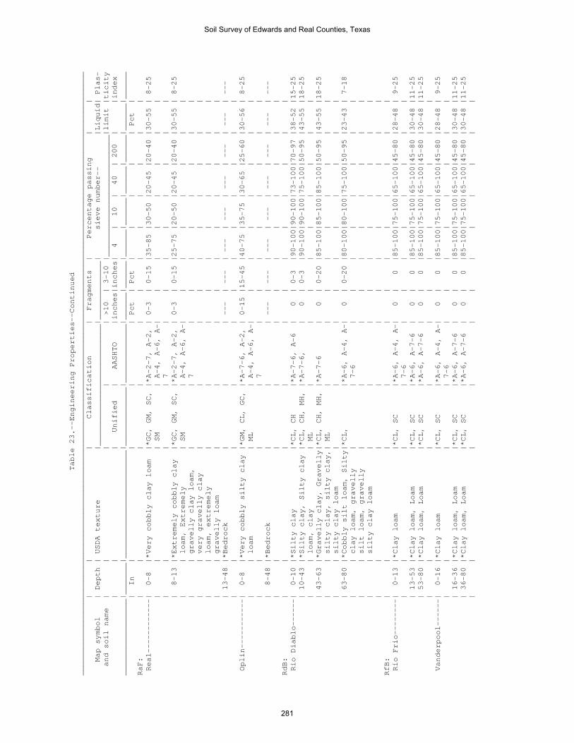
Table 23.--Engineering Properties--Continued
______________________________________________________________________________________________________________________________________
| | | Classification | Fragments | Percentage passing | |
Map symbol | Depth | USDA texture |___________________________|_____________| sieve number-- |Liquid| Plas-
and soil name | | | | | >10 | 3-10 |___________________________|limit |ticity
| | | Unified | AASHTO |inches|inches| 4 | 10 | 40 | 200 | |index
_________________|_______|________________________|_____________|_____________|______|______|______|______|______|______|______|______
| In | | | | Pct | Pct | | | | | Pct |
RaF: | | | | | | | | | | | |
Real------------| 0-8 |*Very cobbly clay loam |*GC, GM, SC, |*A-2-7, A-2, | 0-3 | 0-15 |35-85 |30-50 |20-45 |20-40 |30-55 | 8-25
| | | SM | A-4, A-6, A-| | | | | | | |
| | | | 7 | | | | | | | |
| 8-13 |*Extremely cobbly clay |*GC, GM, SC, |*A-2-7, A-2, | 0-3 | 0-15 |25-75 |20-50 |20-45 |20-40 |30-55 | 8-25
| | loam, Extremely | SM | A-4, A-6, A-| | | | | | | |
| | gravelly clay loam, | | 7 | | | | | | | |
| | very gravelly clay | | | | | | | | | |
| | loam, extremely | | | | | | | | | |
| | gravelly loam | | | | | | | | | |
| 13-48 |*Bedrock | | | --- | --- | --- | --- | --- | --- | --- | ---
| | | | | | | | | | | |
Oplin-----------| 0-8 |*Very cobbly silty clay |*GM, CL, GC, |*A-7-6, A-2, | 0-15 |15-45 |40-75 |35-75 |30-65 |25-60 |30-56 | 8-25
| | loam | ML | A-4, A-6, A-| | | | | | | |
| | | | 7 | | | | | | | |
| 8-48 |*Bedrock | | | --- | --- | --- | --- | --- | --- | --- | ---
| | | | | | | | | | | |
RdB: | | | | | | | | | | | |
Rio Diablo------| 0-10 |*Silty clay |*CL, CH |*A-7-6, A-6 | 0 | 0-3 |90-100|90-100|73-100|70-97 |38-52 |15-25
| 10-43 |*Silty clay, Silty clay |*CL, CH, MH, |*A-7-6, | 0 | 0-3 |90-100|90-100|75-100|50-95 |43-55 |18-25
| | loam, clay | ML | | | | | | | | |
| 43-63 |*Gravelly clay, Gravelly|*CL, CH, MH, |*A-7-6 | 0 | 0-20 |85-100|85-100|85-100|50-95 |43-55 |18-25
| | silty clay, silty clay,| ML | | | | | | | | |
| | silty clay loam | | | | | | | | | |
| 63-80 |*Cobbly silt loam, Silty|*CL, |*A-6, A-4, A-| 0 | 0-20 |80-100|80-100|75-100|50-95 |23-43 | 7-18
| | clay loam, gravelly | | 7-6 | | | | | | | |
| | silt loam, gravelly | | | | | | | | | |
| | silty clay loam | | | | | | | | | |
| | | | | | | | | | | |
RfB: | | | | | | | | | | | |
Rio Frio--------| 0-13 |*Clay loam |*CL, SC |*A-6, A-4, A-| 0 | 0 |85-100|75-100|65-100|45-80 |28-48 | 9-25
| | | | 7-6 | | | | | | | |
| 13-53 |*Clay loam, Loam |*CL, SC |*A-6, A-7-6 | 0 | 0 |85-100|75-100|65-100|45-80 |30-48 |11-25
| 53-80 |*Clay loam, Loam |*CL, SC |*A-6, A-7-6 | 0 | 0 |85-100|75-100|65-100|45-80 |30-48 |11-25
| | | | | | | | | | | |
Vanderpool------| 0-16 |*Clay loam |*CL, SC |*A-6, A-4, A-| 0 | 0 |85-100|75-100|65-100|45-80 |28-48 | 9-25
| | | | 7-6 | | | | | | | |
| 16-36 |*Clay loam, Loam |*CL, SC |*A-6, A-7-6 | 0 | 0 |85-100|75-100|65-100|45-80 |30-48 |11-25
| 36-80 |*Clay loam, Loam |*CL, SC |*A-6, A-7-6 | 0 | 0 |85-100|75-100|65-100|45-80 |30-48 |11-25
| | | | | | | | | | | |
Soil Survey of Edwards and Real Counties, Texas
281

Table 23.--Engineering Properties--Continued
______________________________________________________________________________________________________________________________________
| | | Classification | Fragments | Percentage passing | |
Map symbol | Depth | USDA texture |___________________________|_____________| sieve number-- |Liquid| Plas-
and soil name | | | | | >10 | 3-10 |___________________________|limit |ticity
| | | Unified | AASHTO |inches|inches| 4 | 10 | 40 | 200 | |index
_________________|_______|________________________|_____________|_____________|______|______|______|______|______|______|______|______
| In | | | | Pct | Pct | | | | | Pct |
RsB: | | | | | | | | | | | |
Riverwash-------| 0-80 |*, Extremely gravelly |*GP, GW |*A-1-a | 0-15 | 2-40 | 5-15 | 0-10 | 0-5 | 0-3 |16-25 |NP-3
| | sandy loam | | | | | | | | | |
| | | | | | | | | | | |
Dev-------------| 0-9 |*Very gravelly loam |*GM, GC |*A-2-6, A-2- | 0-5 | 0-35 |40-80 |30-75 |20-65 |15-45 |21-58 | 4-24
| | | | 4, A-6 | | | | | | | |
| 9-37 |*Very gravelly sandy |*GM, GC |*A-2-6, A-2- | 0-5 | 0-35 |40-80 |30-75 |20-65 |15-45 | 0-58 |NP-24
| | loam, Very gravelly | | 4, A-6 | | | | | | | |
| | loam | | | | | | | | | |
| 37-80 |*Very cobbly sandy loam,|*GC-GM, GP- |*A-2-6, A-2-4| 0-10 | 0-35 |10-78 | 5-65 | 5-50 | 5-42 | 0-33 |NP-13
| | Extremely gravelly | GC, SC, SP- | | | | | | | | |
| | sand, extremely cobbly | SC | | | | | | | | |
| | sand | | | | | | | | | |
| | | | | | | | | | | |
RtG: | | | | | | | | | | | |
Rock outcrop----| 0-80 |*Bedrock | | | --- | --- | --- | --- | --- | --- | --- | ---
| | | | | | | | | | | |
Langtry---------| 0-12 |*Very cobbly clay loam |*GC, GP-GC, |*A-2-6, A-2-4| 0-15 |35-75 |20-40 |10-40 |10-40 |10-35 |25-35 | 8-15
| | | GW-GC | | | | | | | | |
| 12-15 |*Extremely cobbly clay |*GC, GP-GC |*A-2-6, A-2-4| 0-15 |50-85 |20-40 |10-40 |10-40 |10-35 |25-35 | 8-15
| | loam, Extremely cobbly | | | | | | | | | |
| | loam, extremely cobbly | | | | | | | | | |
| | silt loam | | | | | | | | | |
| 15-80 |*Bedrock | | | --- | --- | --- | --- | --- | --- | --- | ---
StC: | | | | | | | | | | | |
Spires----------| 0-6 |*Loam |*CL, SC |*A-6, A-7-6 | 0-3 | 0-15 |75-98 |70-98 |70-90 |45-65 |30-45 |15-25
| 6-28 |*Clay |*CH |*A-7-6 | 0-3 | 0-15 |85-100|80-95 |65-80 |65-80 |55-74 |30-45
| 28-38 |*Bedrock | | | --- | --- | --- | --- | --- | --- | --- | ---
| | | | | | | | | | | |
Tarpley---------| 0-7 |*Clay loam |*CH, CL |*A-7-6 | 5-10 | 0-25 |85-100|85-98 |75-95 |65-90 |41-60 |20-38
| 7-18 |*Clay, Cobbly clay |*CH |*A-7-6 | 0-5 | 0-15 |85-100|85-100|85-100|60-95 |51-80 |30-55
| 18-48 |*Bedrock | | | --- | --- | --- | --- | --- | --- | --- | ---
| | | | | | | | | | | |
TeA: | | | | | | | | | | | |
Tarrant, <31 PZ-| 0-7 |*Cobbly silty clay |*CH, GC, SC |*A-7-6, A-7-5| 0-5 |33-77 |55-100|51-100|48-99 |36-95 |51-75 |25-44
| 7-17 |*Very cobbly silty clay |*CH, GC, SC |*A-7-6, A-7-5| 0-5 |33-77 |55-100|51-100|48-99 |36-95 |51-75 |25-44
| 17-80 |*Bedrock | | | --- | --- | --- | --- | --- | --- | --- | ---
| | | | | | | | | | | |
Eckrant---------| 0-9 |*Very cobbly silty clay |*CH, CL |*A-7-6 | 0-25 |10-50 |75-100|71-100|70-98 |65-94 |47-73 |25-45
| 9-80 |*Bedrock | | | --- | --- | --- | --- | --- | --- | --- | ---
| | | | | | | | | | | |
Soil Survey of Edwards and Real Counties, Texas
282
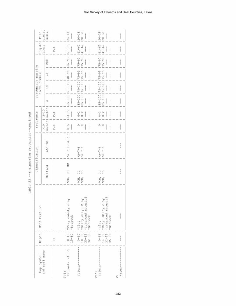
Table 23.--Engineering Properties--Continued
______________________________________________________________________________________________________________________________________
| | | Classification | Fragments | Percentage passing | |
Map symbol | Depth | USDA texture |___________________________|_____________| sieve number-- |Liquid| Plas-
and soil name | | | | | >10 | 3-10 |___________________________|limit |ticity
| | | Unified | AASHTO |inches|inches| 4 | 10 | 40 | 200 | |index
_________________|_______|________________________|_____________|_____________|______|______|______|______|______|______|______|______
| In | | | | Pct | Pct | | | | | Pct |
| | | | | | | | | | | |
| | | | | | | | | | | |
TvB: | | | | | | | | | | | |
Tarrant, <31 PZ-| 0-15 |*Very cobbly clay |*CH, GC, SC |*A-7-6, A-7-5| 0-5 |33-77 |55-100|51-100|48-99 |36-95 |51-75 |25-44
| 15-80 |*Bedrock | | | --- | --- | --- | --- | --- | --- | --- | ---
| | | | | | | | | | | |
Valera----------| 0-10 |*Clay |*CH, CL |*A-7-6 | 0 | 0-2 |85-100|75-100|75-95 |75-90 |41-62 |20-38
| 10-30 |*Silty clay, Clay |*CH, CL |*A-7-6 | 0 | 0-2 |85-100|75-100|75-95 |75-90 |41-62 |20-38
| 30-32 |*Cemented material | | | --- | --- | --- | --- | --- | --- | --- | ---
| 32-80 |*Bedrock | | | --- | --- | --- | --- | --- | --- | --- | ---
| | | | | | | | | | | |
VaA: | | | | | | | | | | | |
Valera----------| 0-14 |*Clay |*CH, CL |*A-7-6 | 0 | 0-2 |85-100|75-100|75-95 |75-90 |41-62 |20-38
| 14-32 |*Clay, Silty clay |*CH, CL |*A-7-6 | 0 | 0-2 |85-100|75-100|75-95 |75-90 |41-62 |20-38
| 32-35 |*Cemented material | | | --- | --- | --- | --- | --- | --- | --- | ---
| 35-80 |*Bedrock | | | --- | --- | --- | --- | --- | --- | --- | ---
| | | | | | | | | | | |
W: | | | | | | | | | | | |
Water-----------| --- | --- | --- | --- | --- | --- | --- | --- | --- | --- | --- | ---
_________________|_______|________________________|_____________|_____________|______|______|______|______|______|______|______|______
Soil Survey of Edwards and Real Counties, Texas
283

Table 24.--Physical Soil Properties
(Entries under "Erosion factors--T" apply to the entire profile. Entries under "Wind erodibility group" and "Wind
erodibility index" apply only to the surface layer. Absence of an entry indicates that data were not estimated.)
________________________________________________________________________________________________________________________
| | | | | | | |Erosion factors|Wind |Wind
Map symbol | Depth | Clay | Moist | Permea- |Available| Linear | Organic |_______________|erodi-|erodi-
and soil name | | | bulk | bility | water |extensi- | matter | | | |bility|bility
| | | density | (Ksat) |capacity | bility | | Kw | Kf | T |group |index
_____________________|_______|______|_________|_____________|_________|_________|_________|_____|_____|___|______|______
| In | Pct | g/cc | In/hr | In/in | Pct | Pct | | | | |
CkB: | | | | | | | | | | | |
Campwood------------| 0-7 | 40-55|1.15-1.55| 0.06-0.2 |0.10-0.18| 6.0-8.9 | 1.0-5.0 | .32 | .32 | 5 | 4 | 86
| 7-47 | 40-60|1.25-1.50| 0.06-0.2 |0.10-0.18| 9.0-25.0| 1.0-3.0 | .32 | .32 | | |
| 47-80 | 35-60|1.25-1.55| 0.06-0.2 |0.08-0.18| 9.0-25.0| 0.1-1.0 | .32 | .32 | | |
| | | | | | | | | | | |
Knippa, >27 PZ------| 0-6 | 40-55|1.30-1.45| 0.2-0.6 |0.15-0.20| 6.0-8.9 | 1.0-4.0 | .32 | .32 | 5 | 4 | 86
| 6-39 | 40-55|1.30-1.45| 0.2-0.6 |0.15-0.20| 6.0-8.9 | 1.0-2.0 | .32 | .32 | | |
| 39-80 | 30-55|1.35-1.50| 0.2-0.6 |0.14-0.20| 6.0-8.9 | 0.2-1.0 | .32 | .32 | | |
| | | | | | | | | | | |
CoB: | | | | | | | | | | | |
Cho-----------------| 0-12 | 10-27|1.30-1.50| 0.6-2 |0.07-0.12| 0.0-2.9 | 1.0-2.0 | .17 | .32 | 2 | 8 | 0
| 12-14 | --- | --- | 0.06-2 | --- | --- | --- | --- | --- | | |
| 14-80 | 10-35|1.40-1.60| 0.6-2 |0.05-0.10| 0.0-2.9 | 0.1-1.0 | .15 | .32 | | |
| | | | | | | | | | | |
Angelo--------------| 0-12 | 27-40|1.25-1.45| 0.6-2 |0.14-0.20| 3.0-5.9 | 1.0-4.0 | .32 | .32 | 3 | 6 | 48
| 12-25 | 27-45|1.35-1.55| 0.2-0.6 |0.14-0.20| 6.0-8.9 | 0.1-2.0 | .32 | .32 | | |
| 25-56 | 27-45|1.40-1.60| 0.6-2 |0.14-0.20| 3.0-5.9 | 0.1-1.0 | .32 | .32 | | |
| 56-80 | --- | --- | 0.06-2 | --- | --- | --- | --- | --- | | |
| | | | | | | | | | | |
DeB: | | | | | | | | | | | |
Dev-----------------| 0-9 | 8-27|1.10-1.50| 2-6 |0.05-0.13| 0.0-2.9 | 1.0-7.0 | .10 | .32 | 5 | 8 | 0
| 9-37 | 1-27|1.10-1.50| 2-6 |0.05-0.13| 0.0-2.9 | 1.0-7.0 | .10 | .32 | | |
| 37-80 | 1-20|1.30-1.50| 6-20 |0.01-0.04| 0.0-2.9 | 0.5-1.0 | .10 | .15 | | |
| | | | | | | | | | | |
Riverwash-----------| 0-80 | 0-2 | --- | 6-20 |0.00-0.05| 0.0-2.9 | 0.0-1.0 | .02 | .02 | 5 | 8 | 0
| | | | | | | | | | | |
DnD: | | | | | | | | | | | |
Dina----------------| 0-8 | 27-40|1.25-1.55| 0.6-2 |0.05-0.11| 3.0-5.9 | 1.0-11 | .20 | .43 | 2 | 8 | 0
| 8-32 | 40-75|1.25-1.45| 0.2-0.6 |0.03-0.05| 6.0-8.9 | 1.0-4.0 | .10 | .32 | | |
| 32-80 | --- | --- | 0.2-2 | --- | --- | --- | --- | --- | | |
| | | | | | | | | | | |
Eckrant-------------| 0-7 | 35-45|1.35-1.55| 0.2-0.6 |0.05-0.12| 3.0-5.9 | 2.0-11 | .15 | .32 | 1 | 8 | 0
| 7-16 | 40-60|1.35-1.60| 0.2-0.6 |0.05-0.12| 3.0-5.9 | 2.0-11 | .10 | .32 | | |
| 16-80 | --- | --- | 0.06-2 | --- | --- | --- | --- | --- | | |
| | | | | | | | | | | |
EcF: | | | | | | | | | | | |
Eckrant-------------| 0-9 | 35-45|1.35-1.55| 0.2-0.6 |0.05-0.12| 3.0-5.9 | 2.0-11 | .15 | .32 | 1 | 8 | 0
| 9-80 | --- | --- | 0.06-2 | --- | --- | --- | --- | --- | | |
| | | | | | | | | | | |
Rock outcrop--------| 0-80 | --- | --- | 0.06-20 | --- | --- | --- | --- | --- | - | --- | ---
| | | | | | | | | | | |
Soil Survey of Edwards and Real Counties, Texas
284

Table 24.-Physical Soil Properties--Continued
________________________________________________________________________________________________________________________
| | | | | | | |Erosion factors|Wind |Wind
Map symbol | Depth | Clay | Moist | Permea- |Available| Linear | Organic |_______________|erodi-|erodi-
and soil name | | | bulk | bility | water |extensi- | matter | | | |bility|bility
| | | density | (Ksat) |capacity | bility | | Kw | Kf | T |group |index
_____________________|_______|______|_________|_____________|_________|_________|_________|_____|_____|___|______|______
| In | Pct | g/cc | In/hr | In/in | Pct | Pct | | | | |
EcG: | | | | | | | | | | | |
Eckrant-------------| 0-11 | 35-45|1.35-1.55| 0.2-0.6 |0.05-0.12| 3.0-5.9 | 2.0-11 | .15 | .32 | 1 | 8 | 0
| 11-80 | --- | --- | 0.06-2 | --- | --- | --- | --- | --- | | |
| | | | | | | | | | | |
Rock outcrop--------| 0-80 | --- | --- | 0.06-20 | --- | --- | --- | --- | --- | - | --- | ---
| | | | | | | | | | | |
ErB: | | | | | | | | | | | |
Ector---------------| 0-3 | 27-35|1.30-1.55| 0.6-2 |0.10-0.14| 0.0-2.9 | 1.0-3.0 | .15 | .32 | 1 | 8 | 0
| 3-7 | 20-40|1.30-1.55| 0.6-2 |0.02-0.06| 0.0-2.9 | 1.0-3.0 | .10 | .32 | | |
| 7-80 | --- | --- | 0.06-2 | --- | --- | --- | --- | --- | | |
| | | | | | | | | | | |
ErF: | | | | | | | | | | | |
Ector---------------| 0-8 | 12-27|1.30-1.45| 0.6-2 |0.06-0.12| 0.0-2.9 | 1.0-3.0 | .15 | .32 | 1 | 8 | 0
| 8-80 | --- | --- | 0.06-2 | --- | --- | --- | --- | --- | | |
| | | | | | | | | | | |
Rock outcrop--------| 0-80 | --- | --- | 0.06-20 | --- | --- | --- | --- | --- | - | --- | ---
| | | | | | | | | | | |
ErG: | | | | | | | | | | | |
Ector---------------| 0-12 | 12-27|1.30-1.45| 0.6-2 |0.06-0.12| 0.0-2.9 | 1.0-3.0 | .15 | .32 | 1 | 8 | 0
| 12-80 | --- | --- | 0.06-2 | --- | --- | --- | --- | --- | | |
| | | | | | | | | | | |
Rock outcrop--------| 0-80 | --- | --- | 0.06-20 | --- | --- | --- | --- | --- | - | --- | ---
| | | | | | | | | | | |
IrA: | | | | | | | | | | | |
Irion---------------| 0-14 | 40-55|1.25-1.45| 0.00-0.06 |0.12-0.18| 6.0-8.9 | 2.0-4.0 | .32 | .32 | 5 | 4 | 86
| 14-54 | 40-55|1.30-1.55| 0.00-0.06 |0.12-0.18| 6.0-8.9 | 1.0-3.0 | .32 | .32 | | |
| 54-72 | 40-55|1.30-1.55| 0.00-0.06 |0.12-0.18| 6.0-8.9 | 0.5-1.0 | .32 | .32 | | |
| 72-80 | --- | --- | 0.00-0.06 | --- | --- | --- | --- | --- | | |
| | | | | | | | | | | |
KrD: | | | | | | | | | | | |
Kerrville-----------| 0-5 | 14-27|1.30-1.50| 0.6-2 |0.09-0.16| 0.0-2.9 | 1.0-4.0 | .20 | .37 | 2 | 8 | 0
| 5-33 | 10-40|1.30-1.50| 0.6-2 |0.03-0.08| 0.0-2.9 | 0.1-1.0 | .10 | .37 | | |
| 33-48 | --- | --- | 0.06-2 | --- | --- | --- | --- | --- | | |
| | | | | | | | | | | |
Real----------------| 0-6 | 22-40|1.25-1.55| 0.6-2 |0.05-0.10| 0.0-2.9 | 2.0-10 | .10 | .32 | 2 | 8 | 0
| 6-9 | 22-40|1.25-1.55| 0.6-2 |0.05-0.10| 0.0-2.9 | 1.0-8.0 | .10 | .32 | | |
| 9-80 | --- | --- | 0.2-2 | --- | --- | --- | --- | --- | | |
| | | | | | | | | | | |
Soil Survey of Edwards and Real Counties, Texas
285

Table 24.--Physical Soil Properties--Continued
________________________________________________________________________________________________________________________
| | | | | | | |Erosion factors|Wind |Wind
Map symbol | Depth | Clay | Moist | Permea- |Available| Linear | Organic |_______________|erodi-|erodi-
and soil name | | | bulk | bility | water |extensi- | matter | | | |bility|bility
| | | density | (Ksat) |capacity | bility | | Kw | Kf | T |group |index
_____________________|_______|______|_________|_____________|_________|_________|_________|_____|_____|___|______|______
| In | Pct | g/cc | In/hr | In/in | Pct | Pct | | | | |
KrF: | | | | | | | | | | | |
Kerrville-----------| 0-6 | 14-27|1.30-1.50| 0.6-2 |0.09-0.16| 0.0-2.9 | 1.0-4.0 | .20 | .37 | 2 | 8 | 0
| 6-19 | 10-40|1.30-1.50| 0.6-2 |0.09-0.16| 0.0-2.9 | 0.5-3.0 | .17 | .37 | | |
| 19-36 | 10-40|1.30-1.50| 0.6-2 |0.03-0.08| 0.0-2.9 | 0.1-1.0 | .10 | .37 | | |
| 36-48 | --- | --- | 0.06-2 | --- | --- | --- | --- | --- | | |
| | | | | | | | | | | |
Real----------------| 0-10 | 27-40|1.25-1.55| 0.6-2 |0.05-0.10| 0.0-2.9 | 2.0-10 | .10 | .32 | 2 | 8 | 0
| 10-80 | --- | --- | 0.2-2 | --- | --- | --- | --- | --- | | |
| | | | | | | | | | | |
| | | | | | | | | | | |
LaE: | | | | | | | | | | | |
Langtry-------------| 0-8 | 18-27|1.30-1.55| 0.6-2 |0.03-0.09| 0.0-2.9 | 1.0-8.0 | .10 | .32 | 1 | 8 | 0
| 8-13 | 18-35|1.30-1.55| 0.6-2 |0.01-0.04| 0.0-2.9 | 1.0-5.0 | .10 | .32 | | |
| 13-80 | --- | --- | 0.06-2 |0.00-0.00| --- | --- | --- | --- | | |
| | | | | | | | | | | |
Rock outcrop--------| 0-80 | --- | --- | 0.06-20 | --- | --- | --- | --- | --- | - | --- | ---
| | | | | | | | | | | |
LkB: | | | | | | | | | | | |
Leakey--------------| 0-8 | 27-40|1.10-1.30| 0.06-0.2 |0.13-0.18| 6.0-8.9 | 2.0-7.0 | .43 | .43 | 2 | 4 | 86
| 8-21 | 60-75|1.15-1.45| 0.00-0.06 |0.08-0.13| 9.0-25.0| 1.0-4.0 | .32 | .32 | | |
| 21-34 | 60-75|1.25-1.50| 0.06-0.2 |0.06-0.10| 9.0-25.0| 0.3-3.0 | .10 | .32 | | |
| 34-60 | 0-0 | --- | 0.00- 0.00 |0.01-0.08| --- | --- | --- | --- | | |
| | | | | | | | | | | |
MaD: | | | | | | | | | | | |
Mailtrail-----------| 0-6 | 27-40|0.80-1.20| 0.6-2 |0.05-0.10| 0.0-2.9 | 3.0-10 | .10 | .15 | 1 | 8 | 0
| 6-15 | 15-40|0.80-1.20| 0.6-2 |0.03-0.08| 0.0-2.9 | 2.0-8.0 | .10 | .15 | | |
| 15-80 | --- |1.60-1.80| 0.06-0.2 |0.01-0.04| --- | 0.0-1.0 | --- | --- | | |
| | | | | | | | | | | |
MmC: | | | | | | | | | | | |
Mailtrail-----------| 0-5 | 27-40|0.80-1.20| 0.6-2 |0.05-0.10| 0.0-2.9 | 3.0-10 | .10 | .15 | 1 | 8 | 0
| 5-13 | 22-40|0.80-1.20| 0.6-2 |0.03-0.08| 0.0-2.9 | 2.0-8.0 | .10 | .15 | | |
| 13-80 | --- |1.60-1.80| 0.06-0.2 |0.01-0.04| --- | 0.0-1.0 | --- | --- | | |
| | | | | | | | | | | |
Mereta--------------| 0-12 | 27-40|1.25-1.45| 0.2-0.6 |0.15-0.20| 3.0-5.9 | 1.0-8.0 | .32 | .32 | 2 | 4 | 86
| 12-19 | 27-45|1.25-1.45| 0.2-0.6 |0.15-0.20| 3.0-5.9 | 0.5-4.0 | .32 | .32 | | |
| 19-80 | --- | --- | 0.06-0.6 | --- | --- | --- | --- | --- | | |
| | | | | | | | | | | |
NuB: | | | | | | | | | | | |
Nuvalde-------------| 0-18 | 27-40|1.10-1.40| 0.6-2 |0.14-0.20| 6.0-8.9 | 1.0-3.0 | .24 | .24 | 5 | 4L | 86
| 18-26 | 30-45|1.20-1.45| 0.6-2 |0.12-0.18| 6.0-8.9 | 0.5-1.0 | .28 | .28 | | |
| 26-80 | 24-40|1.25-1.45| 0.6-2 |0.12-0.18| 3.0-5.9 | 0.1-1.0 | .32 | .32 | | |
| | | | | | | | | | | |
Soil Survey of Edwards and Real Counties, Texas
286

Table 24.--Physical Soil Properties--Continued
________________________________________________________________________________________________________________________
| | | | | | | |Erosion factors|Wind |Wind
Map symbol | Depth | Clay | Moist | Permea- |Available| Linear | Organic |_______________|erodi-|erodi-
and soil name | | | bulk | bility | water |extensi- | matter | | | |bility|bility
| | | density | (Ksat) |capacity | bility | | Kw | Kf | T |group |index
_____________________|_______|______|_________|_____________|_________|_________|_________|_____|_____|___|______|______
| In | Pct | g/cc | In/hr | In/in | Pct | Pct | | | | |
OdA: | | | | | | | | | | | |
Oakalla, >27 PZ-----| 0-11 | 25-40|1.30-1.45| 0.6-2 |0.14-0.19| 3.0-5.9 | 1.0-7.0 | .32 | .32 | 5 | 4L | 86
| 11-27 | 20-40|1.30-1.45| 0.6-2 |0.12-0.18| 3.0-5.9 | 1.0-5.0 | .32 | .32 | | |
| 27-80 | 20-40|1.35-1.50| 0.6-2 |0.12-0.16| 3.0-5.9 | 0.0-2.0 | .32 | .32 | | |
| | | | | | | | | | | |
Dev-----------------| 0-9 | 8-27|1.10-1.50| 2-6 |0.05-0.13| 0.0-2.9 | 1.0-7.0 | .10 | .32 | 4 | 8 | 0
| 9-37 | 1-27|1.10-1.50| 2-6 |0.05-0.13| 0.0-2.9 | 1.0-7.0 | .10 | .32 | | |
| 37-80 | 1-20|1.30-1.50| 6-20 |0.01-0.04| 0.0-2.9 | 0.5-1.0 | .10 | .15 | | |
| | | | | | | | | | | |
OrA: | | | | | | | | | | | |
Orif----------------| 0-12 | 2-16|1.25-1.50| 6-20 |0.05-0.15| 0.0-2.9 | 0.5-4.0 | .10 | .28 | 5 | 3 | 86
| 12-40 | 2-10|1.20-1.50| 6-20 |0.03-0.08| 0.0-2.9 | 0.1-2.0 | .10 | .15 | | |
| 40-80 | 2-10|1.20-1.50| 6-20 |0.03-0.08| 0.0-2.9 | 0.1-2.0 | .10 | .15 | | |
| | | | | | | | | | | |
| | | | | | | | | | | |
OrG: | | | | | | | | | | | |
Oplin---------------| 0-8 | 20-35|1.35-1.55| 0.6-2 |0.10-0.15| 0.0-2.9 | 2.0-10 | .10 | .32 | 1 | 8 | 0
| 8-80 | --- | --- | 0.2-2 | --- | --- | --- | --- | --- | | |
| | | | | | | | | | | |
Rock outcrop--------| 0-80 | --- | --- | 0.06-20 | --- | --- | --- | --- | --- | - | --- | ---
| | | | | | | | | | | |
PeB: | | | | | | | | | | | |
Prade---------------| 0-15 | 40-60|1.10-1.40| 0.2-0.6 |0.05-0.12| 3.0-5.9 | 2.0-7.0 | .15 | .32 | 2 | 8 | 0
| 15-16 | --- | --- | 0.06-0.2 | --- | --- | --- | --- | --- | | |
| 16-60 | --- | --- | 0.06-2 | --- | --- | --- | --- | --- | | |
| | | | | | | | | | | |
Eckrant-------------| 0-8 | 35-45|1.35-1.55| 0.2-0.6 |0.05-0.12| 3.0-5.9 | 2.0-11 | .15 | .32 | 1 | 8 | 0
| 8-12 | 40-60|1.35-1.60| 0.2-0.6 |0.05-0.12| 3.0-5.9 | 2.0-11 | .10 | .32 | | |
| 12-60 | --- | --- | 0.06-2 | --- | --- | --- | --- | --- | | |
| | | | | | | | | | | |
PIT: | | | | | | | | | | | |
Pits----------------| 0-80 | --- | --- | 0.06-20 |0.01-0.10| 0.0-2.9 | --- | .10 | --- | 1 | 8 | 0
| | | | | | | | | | | |
PrC: | | | | | | | | | | | |
Prade---------------| 0-12 | 40-60|1.10-1.40| 0.2-0.6 |0.05-0.12| 3.0-5.9 | 2.0-7.0 | .15 | .32 | 2 | 8 | 0
| 12-15 | --- | --- | 0.06-0.2 | --- | --- | --- | --- | --- | | |
| 15-62 | --- | --- | 0.06-2 | --- | --- | --- | --- | --- | | |
| | | | | | | | | | | |
Tarrant, <31 PZ-----| 0-11 | 40-60|1.10-1.40| 0.2-0.6 |0.05-0.10| 3.0-5.9 | 2.0-7.0 | .15 | .32 | 1 | 8 | 0
| 11-19 | 40-60|1.10-1.40| 0.2-0.6 |0.05-0.10| 3.0-5.9 | 2.0-7.0 | .15 | .32 | | |
| 19-80 | --- | --- | 0.06-2 | --- | --- | --- | --- | --- | | |
| | | | | | | | | | | |
Soil Survey of Edwards and Real Counties, Texas
287

Table 24.--Physical Soil Properties--Continued
________________________________________________________________________________________________________________________
| | | | | | | |Erosion factors|Wind |Wind
Map symbol | Depth | Clay | Moist | Permea- |Available| Linear | Organic |_______________|erodi-|erodi-
and soil name | | | bulk | bility | water |extensi- | matter | | | |bility|bility
| | | density | (Ksat) |capacity | bility | | Kw | Kf | T |group |index
_____________________|_______|______|_________|_____________|_________|_________|_________|_____|_____|___|______|______
| In | Pct | g/cc | In/hr | In/in | Pct | Pct | | | | |
PtB: | | | | | | | | | | | |
Pratley-------------| 0-12 | 35-45|1.30-1.45| 0.6-2 |0.15-0.20| 6.0-8.9 | 2.0-10 | .32 | .32 | 3 | 4 | 86
| 12-19 | 45-60|1.30-1.45| 0.2-0.6 |0.15-0.20| 6.0-8.9 | 1.0-4.0 | .32 | .32 | | |
| 19-24 | 40-60|1.30-1.45| 0.2-0.6 |0.05-0.15| 3.0-5.9 | 0.5-4.0 | .20 | .32 | | |
| 24-30 | --- | --- | 0.06-0.6 | --- | --- | --- | --- | --- | | |
| 30-60 | --- | --- | 0.06-2 | --- | --- | --- | --- | --- | | |
| | | | | | | | | | | |
RaF: | | | | | | | | | | | |
Real----------------| 0-8 | 22-40|1.25-1.55| 0.6-2 |0.05-0.10| 0.0-2.9 | 2.0-10 | .10 | .32 | 2 | 8 | 0
| 8-13 | 22-40|1.25-1.55| 0.6-2 |0.05-0.10| 0.0-2.9 | 1.0-8.0 | .10 | .32 | | |
| 13-48 | --- | --- | 0.2-2 | --- | --- | --- | --- | --- | | |
| | | | | | | | | | | |
Oplin---------------| 0-8 | 20-35|1.35-1.55| 0.6-2 |0.10-0.15| 0.0-2.9 | 2.0-10 | .10 | .32 | 1 | 8 | 0
| 8-48 | --- | --- | 0.2-2 | --- | --- | --- | --- | --- | | |
| | | | | | | | | | | |
RdB: | | | | | | | | | | | |
Rio Diablo----------| 0-10 | 35-50|1.10-1.50| 0.2-0.6 |0.11-0.18| 3.0-5.9 | 1.0-14 | .32 | .32 | 5 | 4 | 86
| 10-43 | 30-55|1.15-1.50| 0.2-0.6 |0.11-0.18| 3.0-5.9 | 0.5-3.0 | .32 | .32 | | |
| 43-63 | 30-55|1.15-1.50| 0.2-0.6 |0.11-0.18| 3.0-5.9 | 0.1-2.0 | .32 | .32 | | |
| 63-80 | 15-40|1.20-1.50| 0.2-0.6 |0.12-0.18| 0.0-2.9 | 0.1-1.0 | .32 | .32 | | |
| | | | | | | | | | | |
RfB: | | | | | | | | | | | |
Rio Frio------------| 0-13 | 27-40|1.30-1.50| 0.6-2 |0.11-0.16| 3.0-5.9 | 0.5-1.0 | .28 | .32 | 5 | 4L | 86
| 13-53 | 20-40|1.40-1.60| 0.6-2 |0.11-0.16| 3.0-5.9 | 0.2-1.0 | .28 | .32 | | |
| 53-80 | 20-40|1.40-1.60| 0.6-2 |0.11-0.16| 3.0-5.9 | 0.1-0.7 | .28 | .32 | | |
| | | | | | | | | | | |
Vanderpool----------| 0-16 | 27-40|1.30-1.50| 0.6-2 |0.11-0.16| 3.0-5.9 | 1.0-3.0 | .28 | .32 | 5 | 4L | 86
| 16-36 | 20-40|1.40-1.60| 0.6-2 |0.11-0.16| 3.0-5.9 | 0.2-1.0 | .28 | .32 | | |
| 36-80 | 20-40|1.40-1.60| 0.6-2 |0.11-0.16| 3.0-5.9 | 0.1-1.0 | .28 | .32 | | |
| | | | | | | | | | | |
RsB: | | | | | | | | | | | |
Riverwash-----------| 0-80 | 0-2 | --- | 6-20 |0.00-0.05| 0.0-2.9 | 0.0-1.0 | .02 | .02 | 5 | 8 | 0
| | | | | | | | | | | |
Dev-----------------| 0-9 | 8-27|1.10-1.50| 2-6 |0.05-0.13| 0.0-2.9 | 1.0-7.0 | .10 | .32 | 5 | 8 | 0
| 9-37 | 1-27|1.10-1.50| 2-6 |0.05-0.13| 0.0-2.9 | 1.0-7.0 | .10 | .32 | | |
| 37-80 | 1-20|1.30-1.50| 6-20 |0.01-0.04| 0.0-2.9 | 0.5-1.0 | .10 | .15 | | |
| | | | | | | | | | | |
RtG: | | | | | | | | | | | |
Rock outcrop--------| 0-80 | --- | --- | 0.06-20 | --- | --- | --- | --- | --- | - | --- | ---
| | | | | | | | | | | |
Langtry-------------| 0-12 | 27-35|1.30-1.55| 0.6-2 |0.03-0.09| 0.0-2.9 | 1.0-8.0 | .10 | .32 | 1 | 8 | 0
| 12-15 | 18-35|1.30-1.55| 0.6-2 |0.01-0.04| 0.0-2.9 | 1.0-5.0 | .10 | .32 | | |
| 15-80 | --- | --- | 0.06-2 |0.00-0.00| --- | --- | --- | --- | | |
| | | | | | | | | | | |
Soil Survey of Edwards and Real Counties, Texas
288

Table 24.--Physical Soil Properties--Continued
________________________________________________________________________________________________________________________
| | | | | | | |Erosion factors|Wind |Wind
Map symbol | Depth | Clay | Moist | Permea- |Available| Linear | Organic |_______________|erodi-|erodi-
and soil name | | | bulk | bility | water |extensi- | matter | | | |bility|bility
| | | density | (Ksat) |capacity | bility | | Kw | Kf | T |group |index
_____________________|_______|______|_________|_____________|_________|_________|_________|_____|_____|___|______|______
| In | Pct | g/cc | In/hr | In/in | Pct | Pct | | | | |
StC: | | | | | | | | | | | |
Spires--------------| 0-6 | 8-27|1.20-1.60| 0.6-2 |0.09-0.16| 3.0-5.9 | 1.0-4.0 | .17 | .32 | 2 | 8 | 0
| 6-28 | 42-57|1.25-1.60| 0.06-0.2 |0.10-0.14| 6.0-8.9 | 1.0-3.0 | .28 | .32 | | |
| 28-38 | --- | --- | 0.2-2 | --- | --- | --- | --- | --- | | |
| | | | | | | | | | | |
Tarpley-------------| 0-7 | 27-40|1.35-1.50| 0.2-0.6 |0.10-0.16| 6.0-8.9 | 1.0-10 | .17 | .32 | 1 | 8 | 0
| 7-18 | 60-80|1.35-1.50| 0.06-0.2 |0.07-0.13| 9.0-25.0| 0.5-4.0 | .32 | .32 | | |
| 18-48 | --- | --- | 0.2-2 | --- | --- | --- | --- | --- | | |
| | | | | | | | | | | |
TeA: | | | | | | | | | | | |
Tarrant, <31 PZ-----| 0-7 | 40-60|1.10-1.40| 0.2-0.6 |0.05-0.10| 3.0-5.9 | 2.0-7.0 | .15 | .32 | 1 | 8 | 0
| 7-17 | 40-60|1.10-1.40| 0.2-0.6 |0.05-0.10| 3.0-5.9 | 2.0-7.0 | .10 | .32 | | |
| 17-80 | --- | --- | 0.06-2 | --- | --- | --- | --- | --- | | |
| | | | | | | | | | | |
Eckrant-------------| 0-9 | 40-60|1.35-1.55| 0.2-0.6 |0.05-0.12| 3.0-5.9 | 2.0-11 | .15 | .32 | 1 | 8 | 0
| 9-80 | --- | --- | 0.06-2 | --- | --- | --- | --- | --- | | |
| | | | | | | | | | | |
TvB: | | | | | | | | | | | |
Tarrant, <31 PZ-----| 0-15 | 40-60|1.10-1.40| 0.2-0.6 |0.05-0.10| 3.0-5.9 | 2.0-7.0 | .15 | .32 | 1 | 8 | 0
| 15-80 | --- | --- | 0.06-2 | --- | --- | --- | --- | --- | | |
| | | | | | | | | | | |
| | | | | | | | | | | |
Valera--------------| 0-10 | 40-55|1.25-1.40| 0.2-0.6 |0.15-0.20| 6.0-8.9 | 1.0-5.0 | .32 | .32 | 2 | 4 | 86
| 10-30 | 40-55|1.25-1.40| 0.2-0.6 |0.15-0.20| 6.0-8.9 | 1.0-5.0 | .32 | .32 | | |
| 30-32 | --- | --- | 0.06-0.6 | --- | --- | --- | --- | --- | | |
| 32-80 | --- | --- | 0.2-2 | --- | --- | --- | --- | --- | | |
| | | | | | | | | | | |
VaA: | | | | | | | | | | | |
Valera--------------| 0-14 | 40-55|1.25-1.40| 0.2-0.6 |0.15-0.20| 6.0-8.9 | 1.0-5.0 | .32 | .32 | 2 | 4 | 86
| 14-32 | 40-55|1.25-1.40| 0.2-0.6 |0.15-0.20| 6.0-8.9 | 1.0-5.0 | .32 | .32 | | |
| 32-35 | --- | --- | 0.06-0.6 | --- | --- | --- | --- | --- | | |
| 35-80 | --- | --- | 0.2-2 | --- | --- | --- | --- | --- | | |
| | | | | | | | | | | |
W: | | | | | | | | | | | |
Water---------------| --- | --- | --- | --- | --- | --- | --- | --- | --- | - | --- | ---
_____________________|_______|______|_________|_____________|_________|_________|_________|_____|_____|___|______|______
Soil Survey of Edwards and Real Counties, Texas
289

Table 25.--Chemical Soil Properties
(Absence of an entry indicates that data were not estimated.) _____________________________________________________________________________________________ | | | | | | | Map symbol | Depth | Cation | Soil |Calcium| Gypsum | Salinity | Sodium and soil name | |exchange |reaction |carbon-| | | adsorp- | |capacity | | ate | | | tion | | | | | | | ratio ______________________|________|_________|_________|_______|________|_______________|_________ | Inches |meq/100 g| pH | Pct | Pct | mmhos/cm | CkB: | | | | | | | Campwood-------------| 0-7 | 35-60 | 7.4-8.4 | 0-40 | 0 | 0.0-2.0 | 0 | 7-47 | 30-50 | 7.4-8.4 | 10-40 | 0 | 0.0-2.0 | 0-2 | 47-80 | 30-50 | 7.4-8.4 | 10-50 | 0 | 0.0-2.0 | 0-7 | | | | | | | Knippa, >27 PZ-------| 0-6 | 20-32 | 7.4-8.4 | 5-30 | 0 | 0.0-2.0 | 0 | 6-39 | 20-32 | 7.4-7.8 | 10-40 | 0 | 0.0-2.0 | 0 | 39-80 | 14-32 | 7.4-8.4 | 20-70 | 0 | 0.0-2.0 | 0 | | | | | | | CoB: | | | | | | | Cho------------------| 0-12 | 10-20 | 7.9-8.4 | 40-65 | 0 | 0 | 0 | 12-14 | --- | --- | --- | 0 | 0 | 0 | 14-80 | 10-20 | 7.9-8.4 | 40-85 | 0 | 0 | 0 | | | | | | | Angelo---------------| 0-12 | 16-25 | 7.9-8.4 | 10-25 | 0 | 0.0-2.0 | 0 | 12-25 | 18-31 | 7.9-8.4 | 10-40 | 0 | 0.0-2.0 | 0 | 25-56 | 16-20 | 7.9-8.4 | 15-60 | 0 | 0.0-2.0 | 0 | 56-80 | --- | --- | --- | --- | --- | --- | | | | | | | DeB: | | | | | | | Dev------------------| 0-9 | 5.0-25 | 7.4-8.4 | 20-90 | 0 | 0 | 0 | 9-37 | 5.0-25 | 7.4-8.4 | 20-90 | 0 | 0 | 0 | 37-80 | 2.0-15 | 7.4-8.4 | 40-90 | 0 | 0 | 0 | | | | | | | Riverwash------------| 0-80 | 0.0-0.0 | 7.9-8.4 | 0 | 0 | 0 | 0-2 | | | | | | | DnD: | | | | | | | Dina-----------------| 0-8 | 20-45 | 5.6-7.8 | 0 | 0 | 0 | 0 | 8-32 | 40-60 | 5.6-7.8 | 0-20 | 0 | 0 | 0 | 32-80 | --- | --- | --- | 0 | 0 | 0 | | | | | | | Eckrant--------------| 0-7 | 40-70 | 6.6-8.4 | 1-8 | 0 | 0.0-2.0 | 0 | 7-16 | 35-60 | 6.6-8.4 | 1-8 | 0 | 0.0-2.0 | 0 | 16-80 | --- | --- | --- | --- | --- | --- | | | | | | | EcF: | | | | | | | Eckrant--------------| 0-9 | 40-70 | 6.6-8.4 | 1-8 | 0 | 0.0-2.0 | 0 | 9-80 | --- | --- | --- | --- | --- | --- | | | | | | | Rock outcrop---------| 0-80 | --- | --- | --- | --- | --- | --- | | | | | | | EcG: | | | | | | | Eckrant--------------| 0-11 | 40-70 | 6.6-8.4 | 1-8 | 0 | 0.0-2.0 | 0 | 11-80 | --- | --- | --- | --- | --- | --- | | | | | | | Rock outcrop---------| 0-80 | --- | --- | --- | --- | --- | --- | | | | | | | ErB: | | | | | | | Ector----------------| 0-3 | 10-20 | 7.9-8.4 | 40-60 | 0 | 0.0-2.0 | 0 | 3-7 | 10-20 | 7.9-8.4 | 40-60 | 0 | 0.0-2.0 | 0 | 7-80 | --- | --- | --- | --- | --- | --- | | | | | | | ErF: | | | | | | | Ector----------------| 0-8 | 10-20 | 7.9-8.4 | 40-60 | 0 | 0 | 0 | 8-80 | --- | --- | --- | --- | --- | --- | | | | | | | Rock outcrop---------| 0-80 | --- | --- | --- | --- | --- | --- | | | | | | |
Soil Survey of Edwards and Real Counties, Texas
290
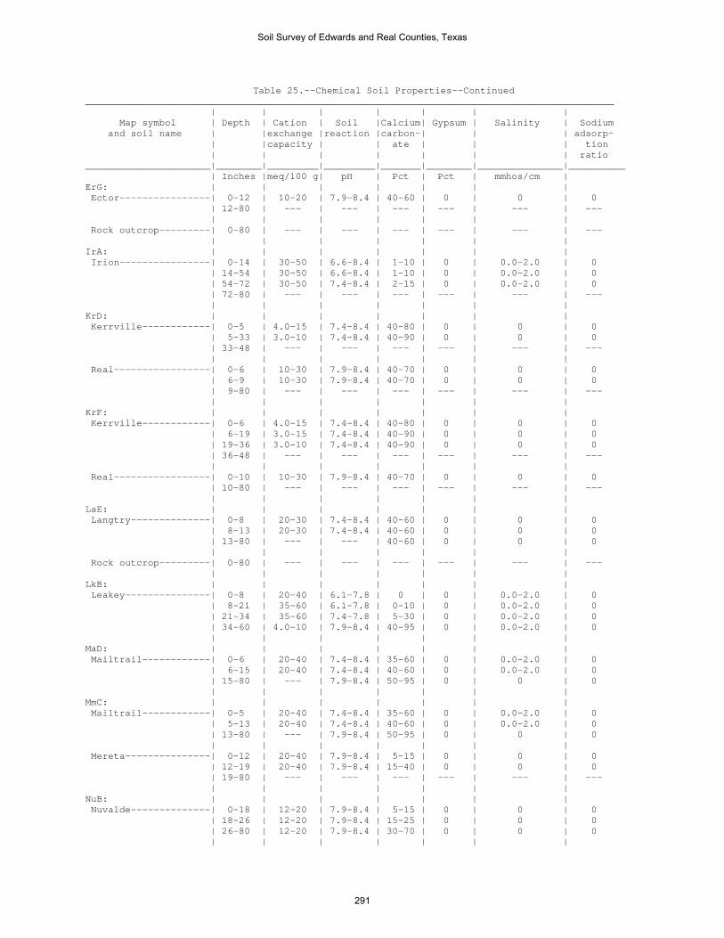
Table 25.--Chemical Soil Properties--Continued _____________________________________________________________________________________________ | | | | | | | Map symbol | Depth | Cation | Soil |Calcium| Gypsum | Salinity | Sodium and soil name | |exchange |reaction |carbon-| | | adsorp- | |capacity | | ate | | | tion | | | | | | | ratio ______________________|________|_________|_________|_______|________|_______________|__________ | Inches |meq/100 g| pH | Pct | Pct | mmhos/cm | ErG: | | | | | | | Ector----------------| 0-12 | 10-20 | 7.9-8.4 | 40-60 | 0 | 0 | 0 | 12-80 | --- | --- | --- | --- | --- | --- | | | | | | | Rock outcrop---------| 0-80 | --- | --- | --- | --- | --- | --- | | | | | | | IrA: | | | | | | | Irion----------------| 0-14 | 30-50 | 6.6-8.4 | 1-10 | 0 | 0.0-2.0 | 0 | 14-54 | 30-50 | 6.6-8.4 | 1-10 | 0 | 0.0-2.0 | 0 | 54-72 | 30-50 | 7.4-8.4 | 2-15 | 0 | 0.0-2.0 | 0 | 72-80 | --- | --- | --- | --- | --- | --- | | | | | | | KrD: | | | | | | | Kerrville------------| 0-5 | 4.0-15 | 7.4-8.4 | 40-80 | 0 | 0 | 0 | 5-33 | 3.0-10 | 7.4-8.4 | 40-90 | 0 | 0 | 0 | 33-48 | --- | --- | --- | --- | --- | --- | | | | | | | Real-----------------| 0-6 | 10-30 | 7.9-8.4 | 40-70 | 0 | 0 | 0 | 6-9 | 10-30 | 7.9-8.4 | 40-70 | 0 | 0 | 0 | 9-80 | --- | --- | --- | --- | --- | --- | | | | | | | KrF: | | | | | | | Kerrville------------| 0-6 | 4.0-15 | 7.4-8.4 | 40-80 | 0 | 0 | 0 | 6-19 | 3.0-15 | 7.4-8.4 | 40-90 | 0 | 0 | 0 | 19-36 | 3.0-10 | 7.4-8.4 | 40-90 | 0 | 0 | 0 | 36-48 | --- | --- | --- | --- | --- | --- | | | | | | | Real-----------------| 0-10 | 10-30 | 7.9-8.4 | 40-70 | 0 | 0 | 0 | 10-80 | --- | --- | --- | --- | --- | --- | | | | | | | LaE: | | | | | | | Langtry--------------| 0-8 | 20-30 | 7.4-8.4 | 40-60 | 0 | 0 | 0 | 8-13 | 20-30 | 7.4-8.4 | 40-60 | 0 | 0 | 0 | 13-80 | --- | --- | 40-60 | 0 | 0 | 0 | | | | | | | Rock outcrop---------| 0-80 | --- | --- | --- | --- | --- | --- | | | | | | | LkB: | | | | | | | Leakey---------------| 0-8 | 20-40 | 6.1-7.8 | 0 | 0 | 0.0-2.0 | 0 | 8-21 | 35-60 | 6.1-7.8 | 0-10 | 0 | 0.0-2.0 | 0 | 21-34 | 35-60 | 7.4-7.8 | 5-30 | 0 | 0.0-2.0 | 0 | 34-60 | 4.0-10 | 7.9-8.4 | 40-95 | 0 | 0.0-2.0 | 0 | | | | | | | MaD: | | | | | | | Mailtrail------------| 0-6 | 20-40 | 7.4-8.4 | 35-60 | 0 | 0.0-2.0 | 0 | 6-15 | 20-40 | 7.4-8.4 | 40-60 | 0 | 0.0-2.0 | 0 | 15-80 | --- | 7.9-8.4 | 50-95 | 0 | 0 | 0 | | | | | | | MmC: | | | | | | | Mailtrail------------| 0-5 | 20-40 | 7.4-8.4 | 35-60 | 0 | 0.0-2.0 | 0 | 5-13 | 20-40 | 7.4-8.4 | 40-60 | 0 | 0.0-2.0 | 0 | 13-80 | --- | 7.9-8.4 | 50-95 | 0 | 0 | 0 | | | | | | | Mereta---------------| 0-12 | 20-40 | 7.9-8.4 | 5-15 | 0 | 0 | 0 | 12-19 | 20-40 | 7.9-8.4 | 15-40 | 0 | 0 | 0 | 19-80 | --- | --- | --- | --- | --- | --- | | | | | | | NuB: | | | | | | | Nuvalde--------------| 0-18 | 12-20 | 7.9-8.4 | 5-15 | 0 | 0 | 0 | 18-26 | 12-20 | 7.9-8.4 | 15-25 | 0 | 0 | 0 | 26-80 | 12-20 | 7.9-8.4 | 30-70 | 0 | 0 | 0 | | | | | | |
Soil Survey of Edwards and Real Counties, Texas
291

Table 25.--Chemical Soil Properties--Continued _____________________________________________________________________________________________ | | | | | | | Map symbol | Depth | Cation | Soil |Calcium| Gypsum | Salinity | Sodium and soil name | |exchange |reaction |carbon-| | | adsorp- | |capacity | | ate | | | tion | | | | | | | ratio ______________________|________|_________|_________|_______|________|_______________|__________ | Inches |meq/100 g| pH | Pct | Pct | mmhos/cm | OdA: | | | | | | | Oakalla, >27 PZ------| 0-11 | 10-20 | 7.9-8.4 | 20-60 | 0 | 0 | 0 | 11-27 | 10-25 | 7.9-8.4 | 40-60 | 0 | 0 | 0 | 27-80 | 10-25 | 7.9-8.4 | 40-60 | 0 | 0 | 0 | | | | | | | Dev------------------| 0-9 | 5.0-25 | 7.4-8.4 | 20-90 | 0 | 0 | 0 | 9-37 | 5.0-25 | 7.4-8.4 | 20-90 | 0 | 0 | 0 | 37-80 | 2.0-15 | 7.4-8.4 | 40-90 | 0 | 0 | 0 | | | | | | | OrA: | | | | | | | Orif-----------------| 0-12 | 1.0-10 | 7.9-8.4 | 30-90 | 0 | 0 | 0 | 12-40 | 1.0-5.0 | 7.9-8.4 | 40-90 | 0 | 0 | 0 | 40-80 | 1.0-5.0 | 7.9-8.4 | 40-90 | 0 | 0 | 0 | | | | | | | OrG: | | | | | | | Oplin----------------| 0-8 | 10-25 | 7.9-8.4 | 10-30 | 0 | 0 | 0 | 8-80 | --- | --- | --- | --- | --- | --- | | | | | | | Rock outcrop---------| 0-80 | --- | --- | --- | --- | --- | --- | | | | | | | PeB: | | | | | | | Prade----------------| 0-15 | 40-70 | 6.6-8.4 | 0-11 | 0 | 0.0-2.0 | 0 | 15-16 | --- | --- | --- | --- | --- | --- | 16-60 | --- | --- | --- | --- | --- | --- | | | | | | | Eckrant--------------| 0-8 | 40-70 | 6.6-8.4 | 1-8 | 0 | 0.0-2.0 | 0 | 8-12 | 35-60 | 6.6-8.4 | 1-8 | 0 | 0.0-2.0 | 0 | 12-60 | --- | --- | --- | --- | --- | --- | | | | | | | PIT: | | | | | | | Pits-----------------| 0-80 | --- | 4.5-8.4 | 0 | 0 | 0.0-8.0 | 0 | | | | | | | PrC: | | | | | | | Prade----------------| 0-12 | 40-70 | 6.6-8.4 | 0-11 | 0 | 0.0-2.0 | 0 | 12-15 | --- | --- | --- | --- | --- | --- | 15-62 | --- | --- | --- | --- | --- | --- | | | | | | | Tarrant, <31 PZ------| 0-11 | 32-60 | 7.4-8.4 | 10-40 | 0 | 0.0-2.0 | 0 | 11-19 | 32-60 | 7.4-8.4 | 10-40 | 0 | 0.0-2.0 | 0 | 19-80 | --- | --- | --- | --- | --- | --- | | | | | | | PtB: | | | | | | | Pratley--------------| 0-12 | 17-31 | 7.4-8.4 | 0-15 | 0 | 0.0-2.0 | 0 | 12-19 | 22-42 | 7.4-8.4 | 3-25 | 0 | 0.0-2.0 | 0 | 19-24 | 22-42 | 7.4-8.4 | 3-25 | 0 | 0.0-2.0 | 0 | 24-30 | --- | --- | --- | --- | --- | --- | 30-60 | --- | --- | --- | --- | --- | --- | | | | | | | RaF: | | | | | | | Real-----------------| 0-8 | 10-30 | 7.9-8.4 | 40-70 | 0 | 0 | 0 | 8-13 | 10-30 | 7.9-8.4 | 40-70 | 0 | 0 | 0 | 13-48 | --- | --- | --- | --- | --- | --- | | | | | | | Oplin----------------| 0-8 | 10-25 | 7.9-8.4 | 10-30 | 0 | 0 | 0 | 8-48 | --- | --- | --- | --- | --- | --- | | | | | | | RdB: | | | | | | | Rio Diablo-----------| 0-10 | 12-35 | 7.4-8.4 | 10-30 | 0 | 0.0-2.0 | 0 | 10-43 | 12-35 | 7.4-8.4 | 20-50 | 0 | 0.0-2.0 | 0 | 43-63 | 12-35 | 7.4-8.4 | 25-60 | 0 | 0.0-2.0 | 0 | 63-80 | 15-30 | 7.4-8.4 | 30-80 | 0 | 0.0-2.0 | 0-2 | | | | | | |
Soil Survey of Edwards and Real Counties, Texas
292
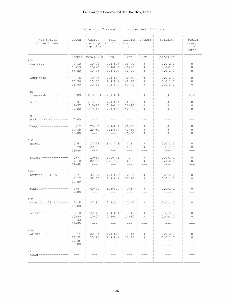
Table 25.--Chemical Soil Properties--Continued _____________________________________________________________________________________________ | | | | | | | Map symbol | Depth | Cation | Soil |Calcium| Gypsum | Salinity | Sodium and soil name | |exchange |reaction |carbon-| | | adsorp- | |capacity | | ate | | | tion | | | | | | | ratio ______________________|________|_________|_________|_______|________|_______________|__________ | Inches |meq/100 g| pH | Pct | Pct | mmhos/cm | RfB: | | | | | | | Rio Frio-------------| 0-13 | 10-22 | 7.4-8.4 | 30-60 | 0 | 0.0-2.0 | 0 | 13-53 | 10-22 | 7.4-8.4 | 40-70 | 0 | 0.0-2.0 | 0 | 53-80 | 10-22 | 7.4-8.4 | 20-70 | 0 | 0.0-2.0 | 0 | | | | | | | Vanderpool-----------| 0-16 | 10-22 | 7.4-8.4 | 30-60 | 0 | 0.0-2.0 | 0 | 16-36 | 10-22 | 7.4-8.4 | 40-70 | 0 | 0.0-2.0 | 0 | 36-80 | 10-22 | 7.4-8.4 | 40-70 | 0 | 0.0-2.0 | 0 | | | | | | | RsB: | | | | | | | Riverwash------------| 0-80 | 0.0-0.0 | 7.9-8.4 | 0 | 0 | 0 | 0-2 | | | | | | | Dev------------------| 0-9 | 5.0-25 | 7.4-8.4 | 20-90 | 0 | 0 | 0 | 9-37 | 5.0-25 | 7.4-8.4 | 20-90 | 0 | 0 | 0 | 37-80 | 2.0-15 | 7.4-8.4 | 40-90 | 0 | 0 | 0 | | | | | | | RtG: | | | | | | | Rock outcrop---------| 0-80 | --- | --- | --- | --- | --- | --- | | | | | | | Langtry--------------| 0-12 | 20-30 | 7.4-8.4 | 40-60 | 0 | 0 | 0 | 12-15 | 20-30 | 7.4-8.4 | 40-60 | 0 | 0 | 0 | 15-80 | --- | --- | 40-60 | 0 | 0 | 0 | | | | | | | StC: | | | | | | | Spires---------------| 0-6 | 17-26 | 6.1-7.8 | 0-1 | 0 | 0.0-2.0 | 0 | 6-28 | 29-36 | 6.1-7.8 | 0-2 | 0 | 0.0-2.0 | 0 | 28-38 | --- | --- | --- | --- | --- | --- | | | | | | | Tarpley--------------| 0-7 | 20-35 | 6.1-7.8 | 0 | 0 | 0.0-2.0 | 0 | 7-18 | 20-35 | 6.1-7.8 | 0-5 | 0 | 0.0-2.0 | 0 | 18-48 | --- | --- | --- | --- | --- | --- | | | | | | | TeA: | | | | | | | Tarrant, <31 PZ------| 0-7 | 32-60 | 7.4-8.4 | 10-40 | 0 | 0.0-2.0 | 0 | 7-17 | 32-60 | 7.4-8.4 | 10-40 | 0 | 0.0-2.0 | 0 | 17-80 | --- | --- | --- | --- | --- | --- | | | | | | | Eckrant--------------| 0-9 | 40-70 | 6.6-8.4 | 1-8 | 0 | 0.0-2.0 | 0 | 9-80 | --- | --- | --- | --- | --- | --- | | | | | | | TvB: | | | | | | | Tarrant, <31 PZ------| 0-15 | 32-60 | 7.4-8.4 | 10-40 | 0 | 0.0-2.0 | 0 | 15-80 | --- | --- | --- | --- | --- | --- | | | | | | | Valera---------------| 0-10 | 20-45 | 7.4-8.4 | 3-15 | 0 | 0.0-2.0 | 0 | 10-30 | 20-45 | 7.4-8.4 | 10-25 | 0 | 0.0-2.0 | 0 | 30-32 | --- | --- | --- | --- | --- | --- | 32-80 | --- | --- | --- | --- | --- | --- | | | | | | | VaA: | | | | | | | Valera---------------| 0-14 | 20-45 | 7.4-8.4 | 3-15 | 0 | 0.0-2.0 | 0 | 14-32 | 20-45 | 7.4-8.4 | 10-25 | 0 | 0.0-2.0 | 0 | 32-35 | --- | --- | --- | --- | --- | --- | 35-80 | --- | --- | --- | --- | --- | --- | | | | | | | W: | | | | | | | Water----------------| --- | --- | --- | --- | --- | --- | --- | | | | | | | ______________________|________|_________|_________|_______|________|_______________|_________
Soil Survey of Edwards and Real Counties, Texas
293
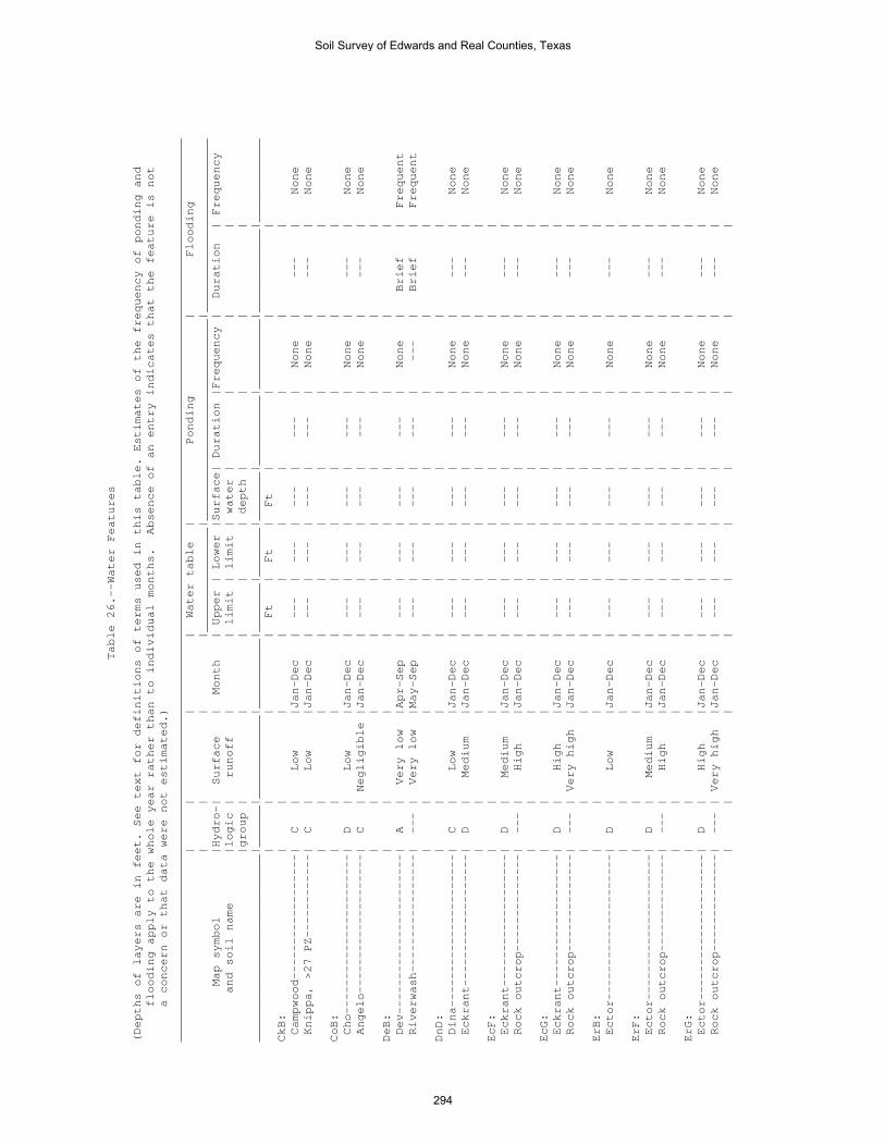
Table 26.--Water Features
(Depths of layers are in feet. See text for definitions of terms used in this table. Estimates of the frequency of ponding and
flooding apply to the whole year rather than to individual months. Absence of an entry indicates that the feature is not
a concern or that data were not estimated.)
__________________________________________________________________________________________________________________________________
| | | | Water table | Ponding | Flooding
| | | |_______________|_____________________________|_________________________
Map symbol |Hydro-| Surface | Month | Upper | Lower |Surface| Duration |Frequency | Duration | Frequency
and soil name |logic | runoff | | limit | limit | water | | | |
|group | | | | | depth | | | |
___________________________|______|____________|__________|_______|_______|_______|__________|__________|____________|____________
| | | | Ft | Ft | Ft | | | |
CkB: | | | | | | | | | |
Campwood------------------| C | Low |Jan-Dec | --- | --- | --- | --- | None | --- | None
Knippa, >27 PZ------------| C | Low |Jan-Dec | --- | --- | --- | --- | None | --- | None
| | | | | | | | | |
CoB: | | | | | | | | | |
Cho-----------------------| D | Low |Jan-Dec | --- | --- | --- | --- | None | --- | None
Angelo--------------------| C | Negligible |Jan-Dec | --- | --- | --- | --- | None | --- | None
| | | | | | | | | |
DeB: | | | | | | | | | |
Dev-----------------------| A | Very low |Apr-Sep | --- | --- | --- | --- | None | Brief | Frequent
Riverwash-----------------| --- | Very low |May-Sep | --- | --- | --- | --- | --- | Brief | Frequent
| | | | | | | | | |
DnD: | | | | | | | | | |
Dina----------------------| C | Low |Jan-Dec | --- | --- | --- | --- | None | --- | None
Eckrant-------------------| D | Medium |Jan-Dec | --- | --- | --- | --- | None | --- | None
| | | | | | | | | |
EcF: | | | | | | | | | |
Eckrant-------------------| D | Medium |Jan-Dec | --- | --- | --- | --- | None | --- | None
Rock outcrop--------------| --- | High |Jan-Dec | --- | --- | --- | --- | None | --- | None
| | | | | | | | | |
EcG: | | | | | | | | | |
Eckrant-------------------| D | High |Jan-Dec | --- | --- | --- | --- | None | --- | None
Rock outcrop--------------| --- | Very high |Jan-Dec | --- | --- | --- | --- | None | --- | None
| | | | | | | | | |
ErB: | | | | | | | | | |
Ector---------------------| D | Low |Jan-Dec | --- | --- | --- | --- | None | --- | None
| | | | | | | | | |
ErF: | | | | | | | | | |
Ector---------------------| D | Medium |Jan-Dec | --- | --- | --- | --- | None | --- | None
Rock outcrop--------------| --- | High |Jan-Dec | --- | --- | --- | --- | None | --- | None
| | | | | | | | | |
ErG: | | | | | | | | | |
Ector---------------------| D | High |Jan-Dec | --- | --- | --- | --- | None | --- | None
Rock outcrop--------------| --- | Very high |Jan-Dec | --- | --- | --- | --- | None | --- | None
| | | | | | | | | |
Soil Survey of Edwards and Real Counties, Texas
294

Table 26.--Water Features--Continued
__________________________________________________________________________________________________________________________________
| | | | Water table | Ponding | Flooding
| | | |_______________|_____________________________|_________________________
Map symbol |Hydro-| Surface | Month | Upper | Lower |Surface| Duration |Frequency | Duration | Frequency
and soil name |logic | runoff | | limit | limit | water | | | |
|group | | | | | depth | | | |
___________________________|______|____________|__________|_______|_______|_______|__________|__________|____________|____________
| | | | Ft | Ft | Ft | | | |
IrA: | | | | | | | | | |
Irion---------------------| D | Negligible |Jan-Apr | --- | --- | --- | --- | --- | --- | None
| | |May-Nov | --- | --- |0.0-6.0| Long |Occasional| --- | None
| | |Dec | --- | --- | --- | --- | --- | --- | None
| | | | | | | | | |
KrD: | | | | | | | | | |
Kerrville-----------------| C | Medium |Jan-Dec | --- | --- | --- | --- | None | --- | None
Real----------------------| D | Medium |Jan-Dec | --- | --- | --- | --- | None | --- | None
| | | | | | | | | |
KrF: | | | | | | | | | |
Kerrville-----------------| C | High |Jan-Dec | --- | --- | --- | --- | None | --- | None
Real----------------------| D | High |Jan-Dec | --- | --- | --- | --- | None | --- | None
| | | | | | | | | |
LaE: | | | | | | | | | |
Langtry-------------------| D | Medium |Jan-Dec | --- | --- | --- | --- | None | --- | None
Rock outcrop--------------| --- | High |Jan-Dec | --- | --- | --- | --- | None | --- | None
| | | | | | | | | |
LkB: | | | | | | | | | |
Leakey--------------------| D | Very high |Jan-Dec | --- | --- | --- | --- | None | --- | None
| | | | | | | | | |
MaD: | | | | | | | | | |
Mailtrail-----------------| D | Medium |Jan-Dec | --- | --- | --- | --- | None | --- | None
| | | | | | | | | |
MmC: | | | | | | | | | |
Mailtrail-----------------| D | Low |Jan-Dec | --- | --- | --- | --- | None | --- | None
Mereta--------------------| D | Negligible |Jan-Dec | --- | --- | --- | --- | None | --- | None
| | | | | | | | | |
NuB: | | | | | | | | | |
Nuvalde-------------------| B | Low |Jan-Dec | --- | --- | --- | --- | None | --- | Rare
| | | | | | | | | |
OdA: | | | | | | | | | |
Oakalla, >27 PZ-----------| B | Low |May-Sep | --- | --- | --- | --- | None | Brief | Occasional
Dev-----------------------| A | Very low |Apr-Sep | --- | --- | --- | --- | None | Brief | Frequent
| | | | | | | | | |
OrA: | | | | | | | | | |
Orif----------------------| A | Very low |Jan-Dec | --- | --- | --- | --- | None | Very brief | Frequent
| | | | | | | | | |
OrG: | | | | | | | | | |
Oplin---------------------| D | High |Jan-Dec | --- | --- | --- | --- | None | --- | None
Rock outcrop--------------| --- | Medium |Jan-Dec | --- | --- | --- | --- | None | --- | None
| | | | | | | | | |
Soil Survey of Edwards and Real Counties, Texas
295

Table 26.--Water Features--Continued
__________________________________________________________________________________________________________________________________
| | | | Water table | Ponding | Flooding
| | | |_______________|_____________________________|_________________________
Map symbol |Hydro-| Surface | Month | Upper | Lower |Surface| Duration |Frequency | Duration | Frequency
and soil name |logic | runoff | | limit | limit | water | | | |
|group | | | | | depth | | | |
___________________________|______|____________|__________|_______|_______|_______|__________|__________|____________|____________
| | | | Ft | Ft | Ft | | | |
PeB: | | | | | | | | | |
Prade---------------------| D | Low |Jan-Dec | --- | --- | --- | --- | None | --- | None
Eckrant-------------------| D | Low |Jan-Dec | --- | --- | --- | --- | None | --- | None
| | | | | | | | | |
PIT: | | | | | | | | | |
Pits----------------------| D | Medium |Jan-Dec | --- | --- | --- | --- | --- | --- | None
| | | | | | | | | |
PrC: | | | | | | | | | |
Prade---------------------| D | Low |Jan-Dec | --- | --- | --- | --- | None | --- | None
Tarrant, <31 PZ-----------| D | Low |Jan-Dec | --- | --- | --- | --- | None | --- | None
| | | | | | | | | |
PtB: | | | | | | | | | |
Pratley-------------------| C | Low |Jan-Dec | --- | --- | --- | --- | None | --- | None
| | | | | | | | | |
RaF: | | | | | | | | | |
Real----------------------| D | Medium |Jan-Dec | --- | --- | --- | --- | None | --- | None
Oplin---------------------| D | Medium |Jan-Dec | --- | --- | --- | --- | None | --- | None
| | | | | | | | | |
RdB: | | | | | | | | | |
Rio Diablo----------------| C | Low |Jan-Dec | --- | --- | --- | --- | None | --- | Rare
| | | | | | | | | |
RfB: | | | | | | | | | |
Rio Frio------------------| B | Low |Jan-Dec | --- | --- | --- | --- | None | --- | Rare
Vanderpool----------------| B | Low |Jan-Dec | --- | --- | --- | --- | None | --- | Rare
| | | | | | | | | |
RsB: | | | | | | | | | |
Riverwash-----------------| --- | Very low |May-Sep | --- | --- | --- | --- | --- | Brief | Frequent
Dev-----------------------| A | Very low |Apr-Sep | --- | --- | --- | --- | None | Brief | Frequent
| | | | | | | | | |
RtG: | | | | | | | | | |
Rock outcrop--------------| --- | Medium |Jan-Dec | --- | --- | --- | --- | None | --- | None
Langtry-------------------| D | High |Jan-Dec | --- | --- | --- | --- | None | --- | None
| | | | | | | | | |
StC: | | | | | | | | | |
Spires--------------------| D | Low |Jan-Dec | --- | --- | --- | --- | None | --- | None
Tarpley-------------------| D | Low |Jan-Dec | --- | --- | --- | --- | None | --- | None
| | | | | | | | | |
TeA: | | | | | | | | | |
Tarrant, <31 PZ-----------| D | Low |Jan-Dec | --- | --- | --- | --- | None | --- | None
Eckrant-------------------| D | Low |Jan-Dec | --- | --- | --- | --- | None | --- | None
| | | | | | | | | |
Soil Survey of Edwards and Real Counties, Texas
296
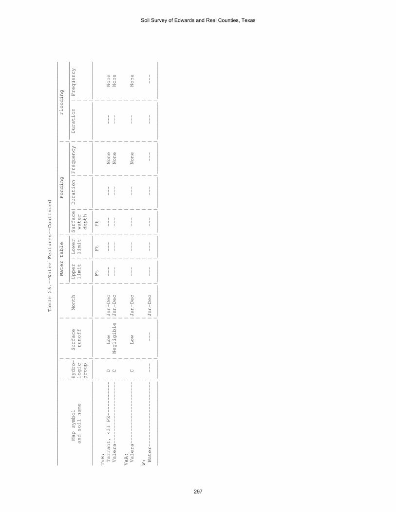
Table 26.--Water Features--Continued
__________________________________________________________________________________________________________________________________
| | | | Water table | Ponding | Flooding
| | | |_______________|_____________________________|_________________________
Map symbol |Hydro-| Surface | Month | Upper | Lower |Surface| Duration |Frequency | Duration | Frequency
and soil name |logic | runoff | | limit | limit | water | | | |
|group | | | | | depth | | | |
___________________________|______|____________|__________|_______|_______|_______|__________|__________|____________|____________
| | | | Ft | Ft | Ft | | | |
TvB: | | | | | | | | | |
Tarrant, <31 PZ-----------| D | Low |Jan-Dec | --- | --- | --- | --- | None | --- | None
Valera--------------------| C | Negligible |Jan-Dec | --- | --- | --- | --- | None | --- | None
| | | | | | | | | |
VaA: | | | | | | | | | |
Valera--------------------| C | Low |Jan-Dec | --- | --- | --- | --- | None | --- | None
| | | | | | | | | |
W: | | | | | | | | | |
Water---------------------| --- | --- |Jan-Dec | --- | --- | --- | --- | --- | --- | ---
___________________________|______|____________|__________|_______|_______|_______|__________|__________|____________|____________
Soil Survey of Edwards and Real Counties, Texas
297

Table 27.--Soil Features (See text for definitions of terms used in this table. Absence of an entry indicates that the feature is
not a concern or that data were not estimated.) ________________________________________________________________________________________________________ | Restrictive layer | Risk of corrosion Map symbol |_____________________________________________________|_________________________ and soil name | | Depth | | | Uncoated | | Kind |to top |Thickness| Hardness | steel | Concrete ________________________|_________________|_______|_________|_________________|____________|____________ | | In | In | | | CkB: | | | | | | Campwood---------------| --- | --- | --- | --- |High |Low Knippa, >27 PZ---------| --- | --- | --- | --- |High |Low | | | | | | CoB: | | | | | | Cho--------------------|Petrocalcic | 7-20 | 2-8 |Strongly cemented|High |Low |Petrocalcic | 9-28 | --- |Weakly cemented | | | | | | | | Angelo-----------------|Lithic bedrock | 40-60 | --- |Indurated |High |Low | | | | | | DeB: | | | | | | Dev--------------------| --- | --- | --- | --- |Moderate |Low Riverwash--------------| --- | --- | --- | --- |Low |Low | | | | | | DnD: | | | | | | Dina-------------------|Lithic bedrock | 20-40 | --- |Indurated |High |Low Eckrant----------------|Lithic bedrock | 8-20 | --- |Indurated |High |Low | | | | | | EcF: | | | | | | Eckrant----------------|Lithic bedrock | 8-20 | --- |Indurated |High |Low Rock outcrop-----------|Lithic bedrock | 0-2 | --- |Indurated |High |Low | | | | | | EcG: | | | | | | Eckrant----------------|Lithic bedrock | 8-20 | --- |Indurated |High |Low Rock outcrop-----------|Lithic bedrock | 0-2 | --- |Indurated |High |Low | | | | | | ErB: | | | | | | Ector------------------|Lithic bedrock | 4-20 | --- |Indurated |High |Low | | | | | | ErF: | | | | | | Ector------------------|Lithic bedrock | 4-20 | --- |Indurated |High |Low Rock outcrop-----------|Lithic bedrock | 0-2 | --- |Indurated |High |Low | | | | | | ErG: | | | | | | Ector------------------|Lithic bedrock | 4-20 | --- |Indurated |High |Low Rock outcrop-----------|Lithic bedrock | 0-2 | --- |Indurated |High |Low | | | | | | IrA: | | | | | | Irion------------------|Lithic bedrock | 60-80 | --- |Indurated |Low |Low | | | | | | KrD: | | | | | | Kerrville--------------|Lithic bedrock | 20-40 | --- |Strongly cemented|High |Low Real-------------------|Paralithic | 8-20 | --- |Moderately |High |Low | bedrock | | | cemented | | | | | | | | KrF: | | | | | | Kerrville--------------|Lithic bedrock | 20-40 | --- |Strongly cemented|High |Low Real-------------------|Paralithic | 8-20 | --- |Moderately |High |Low | bedrock | | | cemented | | |Paralithic | 11-40 | --- |Weakly cemented | | | bedrock | | | | | LaE: | | | | | | Langtry----------------|Lithic bedrock | 4-20 | --- |Indurated |High |Low Rock outcrop-----------|Lithic bedrock | 0-2 | --- |Indurated |High |Low | | | | | | LkB: | | | | | | Leakey-----------------|Petrocalcic | 20-40 | 4-17 |Strongly cemented|High |Low |Petrocalcic | 24-57 | --- |Moderately | | | | | | cemented | | | | | | | |
Soil Survey of Edwards and Real Counties, Texas
298

Table 27.--Soil Features--Continued ________________________________________________________________________________________________________ | Restrictive layer | Risk of corrosion Map symbol |_____________________________________________________|_________________________ and soil name | | Depth | | | Uncoated | | Kind |to top |Thickness| Hardness | steel | Concrete ________________________|_________________|_______|_________|_________________|____________|____________ | | In | In | | | MaD: | | | | | | Mailtrail--------------|Petrocalcic | 4-20 | 1-11 |Indurated |High |Low |Petrocalcic | 5-31 | --- |Moderately | | | | | | cemented | | | | | | | | MmC: | | | | | | Mailtrail--------------|Petrocalcic | 4-20 | 1-11 |Strongly cemented|High |Low |Petrocalcic | 5-31 | --- |Weakly cemented | | | | | | | | Mereta-----------------|Petrocalcic | 14-20 | 1-11 |Strongly cemented|High |Low |Petrocalcic | 15-31 | --- |Weakly cemented | | | | | | | | NuB: | | | | | | Nuvalde----------------| --- | --- | --- | --- |High |Low | | | | | | OdA: | | | | | | Oakalla, >27 PZ--------| --- | --- | --- | --- |Moderate |Low Dev--------------------| --- | --- | --- | --- |Moderate |Low | | | | | | OrA: | | | | | | Orif-------------------| --- | --- | --- | --- |Low |Low | | | | | | OrG: | | | | | | Oplin------------------|Lithic bedrock | 7-20 | --- |Indurated |Moderate |Low Rock outcrop-----------|Lithic bedrock | 0-2 | --- |Indurated |High |Low | | | | | | PeB: | | | | | | Prade------------------|Petrocalcic | 6-20 | 1-11 |Strongly cemented|High |Low |Paralithic | 7-31 | --- |Moderately | | | bedrock | | | cemented | | | | | | | | Eckrant----------------|Lithic bedrock | 8-20 | --- |Indurated |High |Low | | | | | | PIT: | | | | | | Pits-------------------| --- | --- | --- | --- |High |Low | | | | | | PrC: | | | | | | Prade------------------|Petrocalcic | 6-20 | 1-11 |Indurated |High |Low |Paralithic | 7-31 | --- |Moderately | | | bedrock | | | cemented | | | | | | | | Tarrant, <31 PZ--------|Lithic bedrock | 6-20 | --- |Indurated |High |Low | | | | | | PtB: | | | | | | Pratley----------------|Petrocalcic | 22-40 | 1-11 |Strongly cemented|High |Low |Paralithic | 23-51 | --- |Weakly cemented | | | bedrock | | | | | | | | | | | RaF: | | | | | | Real-------------------|Paralithic | 8-20 | --- |Moderately |High |Low | bedrock | | | cemented | | |Paralithic | 11-40 | --- |Weakly cemented | | | bedrock | | | | | | | | | | | Oplin------------------|Lithic bedrock | 7-20 | --- |Indurated |Moderate |Low | | | | | | RdB: | | | | | | Rio Diablo-------------| --- | --- | --- | --- |High |Low | | | | | | RfB: | | | | | | Rio Frio---------------| --- | --- | --- | --- |High |Low Vanderpool-------------| --- | --- | --- | --- |High |Low | | | | | |
Soil Survey of Edwards and Real Counties, Texas
299

Table 27.--Soil Features--Continued ________________________________________________________________________________________________________ | Restrictive layer | Risk of corrosion Map symbol |_____________________________________________________|_________________________ and soil name | | Depth | | | Uncoated | | Kind |to top |Thickness| Hardness | steel | Concrete ________________________|_________________|_______|_________|_________________|____________|____________ | | In | In | | | RsB: | | | | | | Riverwash--------------| --- | --- | --- | --- |Low |Low Dev--------------------| --- | --- | --- | --- |Moderate |Low | | | | | | RtG: | | | | | | Rock outcrop-----------|Lithic bedrock | 0-2 | --- |Indurated |High |Low Langtry----------------|Lithic bedrock | 4-20 | --- |Indurated |High |Low | | | | | | StC: | | | | | | Spires-----------------|Lithic bedrock | 20-40 | --- |Indurated |High |Low Tarpley----------------|Lithic bedrock | 13-20 | --- |Indurated |High |Low | | | | | | TeA: | | | | | | Tarrant, <31 PZ--------|Lithic bedrock | 6-20 | --- |Indurated |High |Low Eckrant----------------|Lithic bedrock | 8-20 | --- |Indurated |High |Low | | | | | | TvB: | | | | | | Tarrant, <31 PZ--------|Lithic bedrock | 6-20 | --- |Indurated |High |Low Valera-----------------|Petrocalcic | 20-40 | 0-17 |Strongly cemented|High |Low | | | | | | |Lithic bedrock | 20-56 | --- |Strongly cemented| | | | | | | | VaA: | | | | | | Valera-----------------|Petrocalcic | 20-40 | 0-17 |Strongly cemented|High |Low |Lithic bedrock | 20-56 | --- |Indurated | | | | | | | | W: | | | | | | Water------------------| --- | --- | --- | --- | --- | --- ________________________|_________________|_______|_________|_________________|____________|____________
Soil Survey of Edwards and Real Counties, Texas
300

Table 28.--Physical Analysis of Selected Soils (The abbreviation “COLE” means coefficient of linear extensibility. Analysis by the USDA-NRCS National
Soil Survey Laboratory, Lincoln, Nebraska unless otherwise footnoted. Dashes indicate that data were not available.)
Particle-size distribution
Sand
In g/cc Cm/Cm
Campwood (1) 0-7 Ap 4.3 7.1 5.3 4.5 3.7 24.9 37.3 37.8 29.2 1.17 0.047
91TX137003 7-19 Bw 0.8 1.7 2.9 2.9 2.7 11.0 38.7 50.3 31.8 1.32 0.090
19-33 Bss1 0.9 1.4 1.8 1.9 1.8 7.8 38.4 53.8 30.4 1.36 0.122
33-47 Bss2 0.6 1.0 1.5 1.7 1.8 6.6 38.8 54.6 33.4 1.30 0.103
47-62 Bss3 0.4 0.9 1.1 1.7 2.0 6.1 39.6 54.3 37.3 1.26 0.117
62-76 Bss4 0.5 0.4 0.9 1.1 2.1 5.0 40.3 54.7 34.1 1.28 0.097
76-80 Bss5 0.2 0.4 0.5 0.8 2.4 4.3 39.4 56.3 33.6 1.28 0.084
Cho (2) 0-10 A 1.6 2.4 2.7 3.7 4.9 15.3 40.9 43.8 32.8 1.1 0.049
92TX137002 10-14 Ak 3.4 2.5 2.6 3.4 4.3 16.2 37.8 46.0 --- --- ---
14-17 Bkm1 27.7 20.7 11.1 8.7 5.8 74.0 16.2 9.8 --- --- ---
17-21 Bkm2 6.7 10.0 10.2 11.8 9.0 47.7 30.8 21.5 --- --- ---
21-46 Crk 1.9 7.2 15.8 15.8 12.6 53.3 33.9 12.8 23.7 1.4 0.002
46-56 Bk 1.5 1.9 2.5 3.7 4.2 13.8 47.3 38.9 --- --- ---
Dina (1,3) 0-3 A1 0.8 1.2 0.9 1.2 0.9 5.0 67.5 27.5 --- --- ---
S81TX385001 3-8 A2 1.8 1.5 0.9 1.4 0.5 6.1 57.2 36.7 37.1 1.29 0.111
8-14 Bt1 2.4 1.2 0.5 1.1 0.6 5.8 32.3 61.9 --- --- ---
14-20 Bt2 1.9 0.8 0.6 0.8 1.0 5.1 23.2 71.7 --- --- ---
20-26 Bt3 0.8 0.4 0.3 0.6 0.8 2.9 21.7 75.4 64.3 1.00 0.223
26-31 BCtk 6.4 3.2 1.6 1.7 1.6 14.5 22.8 62.7 --- --- ---
Ector 0-3 A 2.4 2.1 1.6 2.3 4.4 12.8 51.1 36.1 36.8 1.05 0.052
taxadjunct (4) 3-8 Ak 2.2 2.0 2.1 3.1 3.9 13.3 47.8 38.9 --- --- ---
92TX137001
---------------------------- Pct ------------------------------
Very fine (0.1-
0.05 mm)
Total (2.0-
0.05 mm)1/3 bar 1/3 bar
Very coarse
(2.0-1.0 mm)
Coarse (1.0-0.5mm)
Medium (0.5-
0.25mm)
Fine (0.25-0.1 mm)
Soil name and sample number
Depth Horizon
Water content
Bulk density
COLESilt (0.05-0.002 mm)
Clay (<0.02
mm)
Soil Survey of Edwards and Real Counties, Texas
301
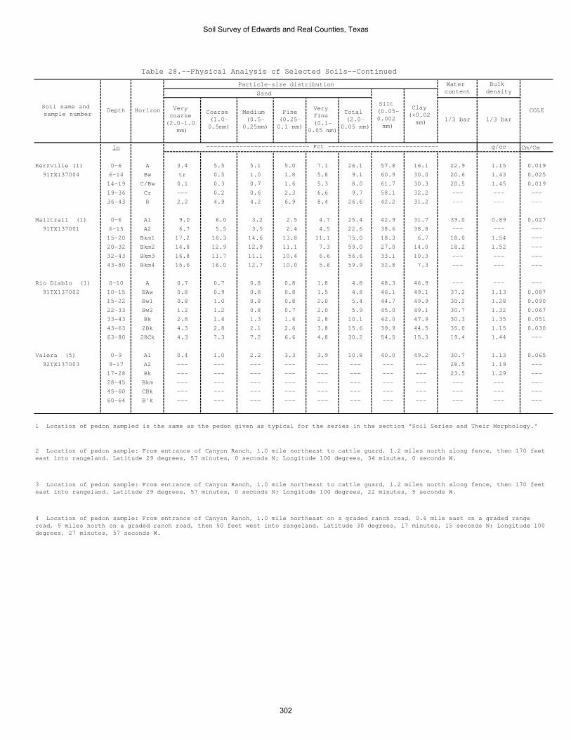
Table 28.--Physical Analysis of Selected Soils--Continued
Particle-size distribution
Sand
In g/cc Cm/Cm
Kerrville (1) 0-6 A 3.4 5.5 5.1 5.0 7.1 26.1 57.8 16.1 22.9 1.15 0.019
91TX137004 6-14 Bw tr 0.5 1.0 1.8 5.8 9.1 60.9 30.0 20.6 1.43 0.025
14-19 C/Bw 0.1 0.3 0.7 1.6 5.3 8.0 61.7 30.3 20.5 1.45 0.019
19-36 Cr --- 0.2 0.6 2.3 6.6 9.7 58.1 32.2 --- --- ---
36-43 R 2.2 4.9 4.2 6.9 8.4 26.6 42.2 31.2 --- --- ---
Mailtrail (1) 0-6 A1 9.0 6.0 3.2 2.5 4.7 25.4 42.9 31.7 39.0 0.89 0.027
91TX137001 6-15 A2 6.7 5.5 3.5 2.4 4.5 22.6 38.6 38.8 --- --- ---
15-20 Bkm1 17.2 18.3 14.6 13.8 11.1 75.0 18.3 6.7 18.0 1.54 ---
20-32 Bkm2 14.8 12.9 12.9 11.1 7.3 59.0 27.0 14.0 18.2 1.52 ---
32-43 Bkm3 16.8 11.7 11.1 10.4 6.6 56.6 33.1 10.3 --- --- ---
43-80 Bkm4 15.6 16.0 12.7 10.0 5.6 59.9 32.8 7.3 --- --- ---
Rio Diablo (1) 0-10 A 0.7 0.7 0.8 0.8 1.8 4.8 48.3 46.9 --- --- ---
91TX137002 10-15 BAw 0.8 0.9 0.8 0.8 1.5 4.8 46.1 49.1 37.2 1.13 0.087
15-22 Bw1 0.8 1.0 0.8 0.8 2.0 5.4 44.7 49.9 30.2 1.28 0.090
22-33 Bw2 1.2 1.2 0.8 0.7 2.0 5.9 45.0 49.1 30.7 1.32 0.067
33-43 Bk 2.8 1.6 1.3 1.6 2.8 10.1 42.0 47.9 30.3 1.35 0.051
43-63 2Bk 4.3 2.8 2.1 2.6 3.8 15.6 39.9 44.5 35.0 1.15 0.030
63-80 2BCk 4.3 7.3 7.2 6.6 4.8 30.2 54.5 15.3 19.4 1.44 ---
Valera (5) 0-9 A1 0.4 1.0 2.2 3.3 3.9 10.8 40.0 49.2 30.7 1.13 0.065
92TX137003 9-17 A2 --- --- --- --- --- --- --- --- 28.5 1.19 ---
17-28 Bk --- --- --- --- --- --- --- --- 23.5 1.29 ---
28-45 Bkm --- --- --- --- --- --- --- --- --- --- ---
45-60 CBk --- --- --- --- --- --- --- --- --- --- ---
60-64 B'k --- --- --- --- --- --- --- --- --- --- ---
---------------------------- Pct ------------------------------
Bulk density
COLESilt (0.05-0.002 mm)
Clay (<0.02
mm) 1/3 bar 1/3 bar
Soil name and sample number
Depth Horizon
Water content
Very coarse
(2.0-1.0 mm)
Coarse (1.0-0.5mm)
Medium (0.5-
0.25mm)
Fine (0.25-0.1 mm)
Very fine (0.1-
0.05 mm)
Total (2.0-
0.05 mm)
4 Location of pedon sample: From entrance of Canyon Ranch, 1.0 mile northeast on a graded ranch road, 0.6 mile east on a graded range road, 5 miles north on a graded ranch road, then 50 feet west into rangeland. Latitude 30 degrees, 17 minutes, 15 seconds N; Longitude 100 degrees, 27 minutes, 57 seconds W.
1 Location of pedon sampled is the same as the pedon given as typical for the series in the section "Soil Series and Their Morphology."
2 Location of pedon sample: From entrance of Canyon Ranch, 1.0 mile northeast to cattle guard, 1.2 miles north along fence, then 170 feet east into rangeland. Latitude 29 degrees, 57 minutes, 0 seconds N; Longitude 100 degrees, 34 minutes, 0 seconds W.
3 Location of pedon sample: From entrance of Canyon Ranch, 1.0 mile northeast to cattle guard, 1.2 miles north along fence, then 170 feet east into rangeland. Latitude 29 degrees, 57 minutes, 0 seconds N; Longitude 100 degrees, 22 minutes, 5 seconds W.
Soil Survey of Edwards and Real Counties, Texas
302

Table 29.--Chemical Analysis of Selected Soils
(Analysis by the USDA-NRCS National Soil Survey Laboratory, Lincoln, Nebraska unless otherwise footnoted. Dashes indicate that
analyses were not made.)
Ca
Mg
Na
K
In
Pct
Pct
pH
(dS/m)
Pct
Pct
Campwood (1)
0-7
Ap
52.4 (2)
3.2
0.2
1.3
100
2.56
7.9
0.77
tr
145
91TX137003
7-19
AB
62.1 (2)
2.5
0.2
1.1
100
1.76
8.0
0.39
tr
134
19-33
Bss1
60.1 (2)
3.5
0.4
0.8
100
1.38
8.1
0.35
11
32
33-47
Bss2
64.7 (2)
3.0
1.2
0.8
100
1.21
8.2
0.37
23
31
47-62
Bss3
60.4 (2)
3.9
2.5
0.8
100
0.96
8.3
0.49
46
29
62-76
Bss4
64.6 (2)
4.0
4.1
1.0
100
0.60
8.3
0.97
79
22
76-80
Bss5
62.7 (2)
4.7
5.6
0.9
100
0.40
8.0
2.30
957
10
Cho (2)
0-10
A64.3 (2)
1.8
0.1
1.1
100
2.64
7.7
0.49
tr
tr
36
92TX137002
10-14
Ak
55.4 (2)
1.6
0.1
0.8
100
2.57
7.8
0.60
tr
tr
30
14-17
Bkm1
49.8 (2)
0.5
0.1
0.1
100
0.47
7.9
---
---
493
17-21
Bkm2
48.0 (2)
0.5
0.1
0.1
100
0.48
8.0
0.55
12
88
21-46
Crk
47.6 (2)
0.5
0.1
0.1
100
0.14
8.1
---
---
383
46-56
Bk
65.2 (2)
1.9
0.8
0.5
100
0.71
7.8
1.26
22
38
Dina (1,3)
0-3
A1
40.5
1.8
0.1
0.8
100
5.98
7.2
0.7
00
---
S81TX385001
3-8
A2
36.3
1.4
0.1
0.5
100
2.51
7.2
0.6
00
---
8-14
Bt1
47.9
1.9
0.1
0.6
100
1.75
7.0
0.6
00
---
14-20
Bt2
51.7
2.1
0.2
0.6
100
1.46
7.0
0.4
00
---
20-26
Bt3
57.3
2.2
0.3
0.6
100
1.29
7.0
0.3
01
---
26-31
BCtk
77.5
1.8
0.2
1.0
100
0.72
7.2
0.6
00
19.3
Ector
0-3
A73.3 (2)
2.2
0.1
1.0
100
4.34
7.2
2.56
tr
tr
12
taxadjunct (4)
3-7
Ak
75.4 (2)
1.1
0.2
0.8
100
4.60
7.5
0.64
tr
tr
22
92TX137001
Sodium
adsorption
ratio (SAR)
Exchange-
able
sodium
(ESP)
Calcium
carbonate
equivalent
Meq/100g
Soil name and sample
number
Depth
Horizon
Extractable bases
Base
satura-
tion
(sum)
Organic
carbon
pH 1:1
(soil:
water)
Electric
Conductivity
Soil Survey of Edwards and Real Counties, Texas
303

Table 29.--Chemical Analysis of Selected Soils--Continued
Ca
Mg
Na
K
In
Pct
Pct
pH
(dS/m)
Pct
Pct
Kerrville (2)
0-6
A42.0 (2)
1.9
0.1
0.6
100
0.92
8.0
0.77
tr
177
91TX137004
6-14
Bw
37.2 (2)
3.6
0.1
0.2
100
0.38
8.1
0.59
tr
175
14-19
C/Bw
42.7 (2)
1.8
0.1
0.2
100
0.18
8.2
---
---
274
19-36
Cr
40.0 (2)
2.3
0.1
0.2
100
0.06
8.2
---
---
tr
74
36-43
R---
---
---
---
---
---
---
---
---
---
---
Mailtrail (2)
0-6
A1
63.0 (2)
1.8
0.1
1.2
100
5.55
7.8
1.01
---
tr
39
91TX137001
6-15
A2
66.5 (2)
1.2
0.1
0.7
100
5.60
7.9
0.79
tr
tr
36
15-20
Bkm1
44.7 (2)
0.3
tr
tr
100
0.41
8.2
---
---
---
94
20-32
Bkm2
46.6 (2)
0.2
tr
0.1
100
0.52
8.3
---
---
---
90
32-43
Bkm3
41.9 (2)
0.2
tr
0.1
100
0.14
8.4
---
---
793
43-60
Bkm4
40.8 (2)
0.1
0.1
---
100
0.15
8.3
---
---
---
93
Rio Diablo (2)
0-10
A63.2 (2)
1.9
0.1
1.8
100
1.94
---
0.47
tr
tr
18
91TX137002
10-15
BAw
63.7 (2)
2.3
0.2
1.2
100
1.40
---
0.42
tr
120
15-22
Bw1
54.7 (2)
2.4
0.2
1.0
100
1.15
---
---
---
121
22-33
Bw2
62.2 (2)
3.4
0.3
0.8
100
0.92
---
---
---
123
33-43
Bk
57.0 (2)
2.8
0.3
0.9
100
0.66
---
---
---
226
43-63
2Bk
53.5 (2)
2.7
0.3
0.5
100
0.38
---
0.42
12
45
63-80
2BCk
43.9 (2)
1.3
0.3
0.1
100
0.14
---
---
---
177
Valera (5)
0-9
A1
61.8 (2)
1.9
0.1
1.4
100
2.06
7.7
0.53
tr
tr
35
92TX137003
9-17
A2
---
---
---
---
---
---
---
---
---
---
---
17-28
Bk
---
---
---
---
---
---
---
---
---
---
---
28-45
Bkm
---
---
---
---
---
---
---
---
---
---
---
45-60
CBk
---
---
---
---
---
---
---
---
---
---
---
60-64
B'k
---
---
---
---
---
---
---
---
---
---
---
Meq/100g
Electric
Conductivity
Sodium
adsorption
ratio (SAR)
Exchange-
able
sodium
(ESP)
Calcium
carbonate
equivalent
Soil name and sample
number
Depth
Horizon
Extractable bases
Base
satura-
tion
(sum)
Organic
carbon
pH 1:1
(soil:
water)
1 Location of pedon sampled is the same as the pedon given as typical for the series in the section "Soil Series and Their Morphology."
2 Location of pedon sample: From entrance of Canyon Ranch, 1.0 mile northeast to cattle guard, 1.2 miles north along fence, then 170 feet east into
rangeland. Latitude 29 degrees, 57 minutes, 0 seconds N; Longitude 100 degrees, 34 minutes, 0 seconds W.
3 Location of pedon sample: From entrance of Canyon Ranch, 1.0 mile northeast to cattle guard, 1.2 miles north along fence, then 170 feet east into
rangeland. Latitude 29 degrees, 57 minutes, 0 seconds N; Longitude 100 degrees, 22 minutes, 5 seconds W.
4 Location of pedon sample: From entrance of Canyon Ranch, 1.0 mile northeast on a graded ranch road, 0.6 mile east on a graded range road, 5 miles
north on a graded ranch road, then 50 feet west into rangeland. Latitude 30 degrees, 17 minutes, 15 seconds N; Longitude 100 degrees, 27 minutes, 57
seconds W.
Soil Survey of Edwards and Real Counties, Texas
304

Table 30.--Clay Mineralogy of Selected Soils
(Analysis by the USDA-NRCS National Soil Survey Laboratory, Lincoln, Nebraska. Relative Peak Size: 6—no peaks; 5—very large; 4—large;
3—medium; 2—small; 1—very small;. Dashes indicate that analyses was detected.)
Soil name and
sample number
Depth
Horizon
Montmorill-
Mica
Kaolinite
Quartz
Calcite
Montmorillinite-
Montmorillinite-
nite
Mica
Chlorite
In
Campwood (1)
0-7
Ap
22
2---
31
---
91TX137003
47-62
Bss3
33
21
21
---
Cho (2)
0-10
A2
22
13
---
---
92TX137002
10-14
Ak
22
2---
3---
---
14-17
Bkm1
---
11
---
5---
---
17-21
Bkm2
---
12
---
5---
---
Ector (3)
0-3
A3
22
12
---
---
92TX137001
3-7
Ak
31
21
3---
---
Kerrville (1)
0-6
A---
31
---
2---
---
91TX137004
14-19
C/Bw
---
4---
11
---
---
36-43
R---
3---
---
3---
---
Mailtrail (1)
0-6
A1
11
1---
3---
---
91TX137001
15-20
Bkm1
---
---
---
---
5---
---
43-60
Bkm3
---
---
---
---
3---
---
Rio Diablo (1)
0-10
A2
22
13
11
91TX137002
22-33
Bw2
22
21
31
---
43-63
2Bk
22
21
31
---
Valera (4)
0-9
A1
22
2---
3---
---
92TX137003
3 Location of pedon sample: From entrance of Canyon Ranch, 1.0 mile northeast to cattle guard, 1.2 miles north along fence, then 170 feet east
into rangeland. Latitude 29 degrees, 57 minutes, 0 seconds N; Longitude 100 degrees, 22 minutes, 5 seconds W.
4 Location of pedon sample: From entrance of Canyon Ranch, 1.0 mile northeast on a graded ranch road, 0.6 mile east on a graded range road, 5.0
miles north on a graded ranch road, then 50 feet west into rangeland. Latitude 30 degrees, 17 minutes, 15 seconds N; Longitude 100 degrees, 27
minutes, 57 seconds W.
Peak Size of Total Clay Fraction
1 Location of pedon sampled is the same as the pedon given as typical for the series in the section "Soil Series and Their Morphology."
2 Location of pedon sample: From entrance of Canyon Ranch, 1.0 mile northeast to cattle guard, 1.2 miles north along fence, then 170 feet east
into rangeland. Latitude 29 degrees, 57 minutes, 0 seconds N; Longitude 100 degrees, 34 minutes, 0 seconds W.
Soil Survey of Edwards and Real Counties, Texas
305

Table 31.--Taxonomic Classification of the Soils (An asterisk in the first column indicates a taxadjunct to the series. See text for a description of those characteristics that are outside the range of the series.) ______________________________________________________________________________________________________ | Soil name | Family or higher taxonomic class __________________________|___________________________________________________________________________ Angelo-------------------|Fine-silty, mixed, superactive, thermic Aridic Calciustolls Campwood-----------------|Fine, smectitic, thermic Typic Haplusterts Cho----------------------|Loamy, carbonatic, thermic, shallow Petrocalcic Calciustolls Dev----------------------|Loamy-skeletal, carbonatic, thermic Cumulic Haplustolls Dina---------------------|Clayey-skeletal, smectitic, thermic Pachic Paleustolls Eckrant------------------|Clayey-skeletal, smectitic, thermic Lithic Haplustolls Ector--------------------|Loamy-skeletal, carbonatic, thermic Lithic Calciustolls *Ector--------------------|Loamy-skeletal, mixed, thermic Lithic Calciustolls Irion--------------------|Fine, smectitic, thermic Typic Haplusterts Kerrville----------------|Loamy-skeletal, carbonatic, thermic Typic Calciustepts Knippa-------------------|Fine, mixed, superactive, thermic Vertic Calciustolls Langtry------------------|Loamy-skeletal, carbonatic, hyperthermic Lithic Calciustolls Leakey-------------------|Very-fine, smectitic, thermic Petrocalcic Calciusterts Mailtrail----------------|Loamy-skeletal, carbonatic, thermic, shallow Petrocalcic Calciustolls Mereta-------------------|Clayey, mixed, superactive, thermic, shallow Petrocalcic Calciustolls Nuvalde------------------|Fine-silty, mixed, superactive, thermic Typic Calciustolls Oakalla------------------|Fine-loamy, carbonatic, thermic Cumulic Haplustolls Oplin--------------------|Loamy-skeletal, carbonatic, thermic Lithic Calciustolls Orif---------------------|Sandy-skeletal, carbonatic, thermic Typic Ustifluvents Prade--------------------|Clayey-skeletal, smectitic, thermic Petrocalcic Calciustolls Pratley------------------|Fine, smectitic, thermic Petrocalcic Calciustolls Real---------------------|Loamy-skeletal, carbonatic, thermic, shallow Typic Calciustolls Rio Diablo---------------|Fine, mixed, superactive, thermic Aridic Haplustolls Rio Frio-----------------|Fine-loamy, carbonatic, thermic Typic Calciustepts Spires-------------------|Fine, mixed, active, thermic Rhodic Paleustalfs Tarpley------------------|Clayey, smectitic, thermic Lithic Argiustolls Tarrant------------------|Clayey-skeletal, smectitic, thermic Lithic Calciustolls Valera-------------------|Fine, smectitic, thermic Petrocalcic Calciustolls Vanderpool---------------|Fine-loamy, carbonatic, thermic Typic Haplustolls __________________________|___________________________________________________________________________
Soil Survey of Edwards and Real Counties, Texas
306


The Natural Resources Conservation Service (NRCS) is committed to making itsinformation accessible to all of its customers and employees. If you are experiencingaccessibility issues and need assistance, please contact our Helpdesk by phone at1-800-457-3642 or by e-mail at [email protected]. For assistance withpublications that include maps, graphs, or similar forms of information, you may alsowish to contact our State or local office. You can locate the correct office and phonenumber at http://offices.sc.egov.usda.gov/locator/app.
NRCS Accessibility Statement