DEPARTMENT OF THE INTERIOR Release BUREAU … OF THE INTERIOR BUREAU OF LAND MANAGEMENT MANUAL...
42
Form 1221-2 (June 1969) UNITED STATES DEPARTMENT OF THE INTERIOR BUREAU OF LAND MANAGEMENT MANUAL TRANSMITTAL SHEET Release 8-73 Date 12/03/04 Subject 8110 - IDENTIFYING AND EVALUATING CULTURAL RESOURCES 1. Explanation of Material Transmitted: This release completely revises BLM Manual Section 8110 and 8111. 2. Reports Required: None. 3. Material Superseded: Manual pages superseded by this release are listed under REMOVE below. No other directives are superseded. 4. Filing Instructions: REMOVE INSERT All of 8110 (Rel. 8-38) 8110 All of 8111 (Rel. 8-53) (Total: 24 Sheets) Edward W. Shepard Assistant Director, Renewable Resources and Planning
Transcript of DEPARTMENT OF THE INTERIOR Release BUREAU … OF THE INTERIOR BUREAU OF LAND MANAGEMENT MANUAL...

Form 1221-2
(June 1969)
UNITED STATES
DEPARTMENT OF THE INTERIOR
BUREAU OF LAND MANAGEMENT
MANUAL TRANSMITTAL SHEET
Release
8-73
Date
12/03/04
Subject
8110 - IDENTIFYING AND EVALUATING CULTURAL RESOURCES
1. Explanation of Material Transmitted: This release completely revises BLM Manual
Section 8110 and 8111.
2. Reports Required: None.
3. Material Superseded: Manual pages superseded by this release are listed under REMOVE
below. No other directives are superseded.
4. Filing Instructions:
REMOVE INSERT
All of 8110 (Rel. 8-38) 8110
All of 8111 (Rel. 8-53)
(Total: 24 Sheets)
Edward W. Shepard
Assistant Director,
Renewable Resources and Planning

BLM Manual Rel. 8-73 Supersedes Rel. 8-39, 8-52, 8-53 12/03/04
TC-1 8110 - IDENTIFYING AND EVALUATING CULTURAL RESOURCES - (Public)
Table of Contents .01 Purpose .02 Objective .03 Authority .04 Responsibility .05 References .06 Policy .07 File and Records Maintenance .1 Determining Identification Needs .11 Elements of Identification A. Inventory B. Evaluation C. Documentation .12 Information Needs .13 Planning .14 Land Use Authorizations .15 Environmental Documentation .16 SHPO Views .2 Gathering Cultural Resource Information .21 Kinds of Inventory
A. Class I - Existing Information Inventory B. Class II - Probabilistic Field Survey . C. Class III - Intensive Field Survey .22 Other Information-Gathering Techniques A. Reconnaissance Survey B. Subsurface Probing C. Test Excavation D. Locating Properties of Traditional Cultural Importance
E. Predictive Modeling .23 Survey Requirements and Exceptions .3 Evaluating Legal Significance .31 Legal Standards A. Accountability for Effects on Significant Properties B. The Nature of Significance C. A Uniform System of Significance Measurement
.32 Determining National Register of Historic Places Eligibility A. Specialist Applies the National Register Criteria B. Specialist Applies SHPO Information C. Specialist Makes Staff Recommendation D. Legal Implications of Recommendation

BLM Manual Rel. 8-73 Supersedes Rel. 8-39, 8-52, 8-53 12/03/04
TC-2 8110 - IDENTIFYING AND EVALUATING CULTURAL RESOURCES – (Public) E. The National Register Criteria F. Criteria Exceptions G. National Register of Historic Places Registration
.33 Nationally Significant Properties A. National Historic Landmarks
B. Nationally Significant National Register Properties C. Other Historical Designations D. Identification and Consultation
.4 Categorizing According to Uses .41 Allocation to Use Categories .42 Use Categories
A. Scientific Use B. Conservation for Future Use C. Traditional Use D. Public use E. Experimental Use F. Discharged from Management .43 Relationship between Evaluation and Allocation .44 Consultation with Outside Parties A. Consultation with SHPO B. Consultation with Tribes .5 Documentation and Maintenance of Data, Records, and Maps
.51 Cultural Resource Inventory Records A. Cultural Resource Record Forms B. Survey Record C. Maps and Photographs .52 Maintenance of Inventory and Evaluation Data A. Paper Files B. Digital Data and Automated Files .53 Master Maps .54 Inventory Reports .55 Confidentiality .56 Archival Standards .57 Collections .58 Inventory Updating

BLM Manual Rel. 8-73 Supersedes Rel. 8-39, 8-52, 8-53 12/03/04
TC-3 8110 - IDENTIFYING AND EVALUATING CULTURAL RESOURCES – (Public) .6 External Review .61 SHPO Review .62 Tribal Review .63 Peer Review Appendices
1. List of Selected National Register Bulletins 2. Recording Cultural Resource Locations Using Global Position System (GPS) Technology

BLM Manual Rel. 8-73 Supersedes Rel. 8-39, 8-52, 8-53 12/03/04
.01 8110 - IDENTIFYING AND EVALUATING CULTURAL RESOURCES – (Public) .01 Purpose. This Manual Section provides general direction for identifying, evaluating, categorizing, and allocating to uses all the cultural resources that occur on public lands within a Field Office manager's jurisdiction. .02 Objectives. The objectives of the identification component of the cultural resource management program are to ensure that BLM Field Office managers accomplish the following: A. Locate and record cultural resources on lands they administer and in areas affected by undertakings they authorize. B. Establish the resources' National Register significance and their scientific, cultural, public, traditional, and conservation values as the basis for managing the resources and the surrounding land area over the long term. C. Prepare to enter into land use planning with sound qualitative, quantitative, and geographical information about known and anticipated cultural resources, and with definite goals for their short- and long-term management. D. Maintain permanent, up-to-date records through cooperation with the State Historic Preservation Officer, and encourage their use for appropriate educational, research, and other learning purposes. .03 Authority. (See BLM Manual Section 8100.03.) .04 Responsibility. (See BLM Manual Section 8100.04.) .05 References. (See also BLM Manual Section 8100.05) A. National Programmatic Agreement of March 26, 1997, among the Director, BLM, the Chairman, Advisory Council on Historic Preservation, and the President, National Conference of State Historic Preservation Officers (see BLM Manual Section 8100, Appendix 13). B. "Secretary of the Interior's Standards and Guidelines for Archeology and Historic Preservation," published by the National Park Service at 48 FR 44716, September 29, 1983. C. "Secretary of the Interior’s Standards and Guidelines for Federal Agency Historic Preservation Programs Pursuant to the National Historic Preservation Act,” published by the National Park Service at 63 FR 20496, April 24, 1998.

BLM Manual Rel. 8-73 Supersedes Rel. 8-39, 8-52, 8-53 12/03/04
.05D 8110 - IDENTIFYING AND EVALUATING CULTURAL RESOURCES – (Public) D. "Treatment of Archeological Properties: A Handbook," available from the Advisory Council on Historic Preservation. See also 45 FR 78808, November 26, 1980. E. National Register Bulletin series, published by the National Park Service (see Appendix 1 for selected list).
F. Glossary of Terms, BLM Manual Section 8100. .06 Policy. The BLM's Field Office managers, with the assistance and advice of professionally qualified cultural resource staff, shall: A. Incorporate cultural resource considerations into all aspects of planning and decision making. B. Complete appropriate levels of cultural resource inventory, evaluation, and documentation, at the appropriate stage in planning, for all lands potentially affected by BLM decisions, regardless of ownership. C. Consider the character, importance, potential uses, and appropriate management of cultural resources when inventorying, evaluating, and documenting them. D. Inventory cultural resources that are potentially affected by Section 106 undertakings, by the methods and at a level commensurate with the nature of the proposed undertaking and its likely effects on the protection and management of the cultural resources (see additional guidance in 8110.23 and 8140.2). E. Ensure that only professionally qualified archaeologists, historians, anthropologists, architectural historians, or other specialists as appropriate to the nature of the resources, locate, evaluate, document, or collect cultural resources (see Glossary of Terms, BLM Manual Section 8100: "professionally qualified;” and Section 8100.03).
F. Record all cultural resource locations using Global Positioning System (GPS) technology, at a level of accuracy within a mean error of 12.5 meters or less at a 95 percent confidence level. (See Appendix 2.) G. Allocate cultural resources on public land to the appropriate use categories and manage them in a manner that ensures, protects, or contributes to their assigned uses. H. Cooperate in sharing cultural resource data with State Historic Preservation Offices (SHPO) according to the State's BLM-SHPO Protocol established pursuant to the national Programmatic Agreement, ensuring that records and data bases will be permanently maintained, properly secured, and kept current and readily available to meet agency information needs.
BLM Manual Rel. 8-73 Supersedes Rel. 8-39, 8-52, 8-53 12/03/04
.06I 8110 - IDENTIFYING AND EVALUATING CULTURAL RESOURCES – (Public) I. Withhold sensitive information from public disclosure when disclosure would threaten the resources (see National Historic Preservation Act, Section 304, BLM Manual Section 8100, Appendix 5; and Archaeological Resources Protection Act, Section 9, BLM Manual Section 8100, Appendix 8). J. Provide Federal, tribal, State, and local agencies, qualified professionals, and the public with access to cultural resource information when access would further the BLM's objectives, consistent with the National Historic Preservation Act and the Archaeological Resources Protection Act, and would not result in harm to the resources. .07 File and Records Maintenance. See .11C, .32C, .5, .51-.57. Filing requirements are found in the GRS/BLM Combined Records Schedule (Schedule 4).

BLM Manual Rel. 8-73 Supersedes Rel. 8-39, 8-52, 8-53 12/03/04
.1 8110 - IDENTIFYING AND EVALUATING CULTURAL RESOURCES – (Public) .1 Determining Identification Needs. The timely and adequate professional identification of cultural resources on public lands and in areas affected by BLM's undertakings is essential to making informed resource management and land use decisions. .11 Elements of Identification. Inventory, evaluation, and documentation are the three main elements of identification. Each has a critical role to play in enabling the long-term management and use of cultural resources. A. Inventory is meant to ensure that the nature and distribution of cultural resources on BLM-administered lands (and in areas affected by BLM undertakings) are identified by professional cultural resource staff and made known to the responsible Field Office manager. B. Evaluation is meant to ensure that the significance and use potential of the cultural resources are analyzed and recommended by professional cultural resource staff and approved by the responsible Field Office manager, after appropriate consultation with the State Historic Preservation Officer and tribal officials. C. Documentation is meant to record adequately the resources' location, geographical settings, physical characteristics, and scientific, historical, architectural, traditional, educational, interpretive, and conservation values. Documentation is not done as a separate step but occurs throughout the identification process. Qualified professionals prepare documentation in the course of inventorying and evaluating cultural resources. The BLM works in cooperation with State Historic Preservation Offices to ensure that this documentation is maintained in permanent and secure paper and digital files and databases in a manner that fulfills data sharing requirements of the national Programmatic Agreement and data sharing agreements and programs that exist for individual states. .12 Information Needs. During the earliest feasible stage of land use planning or environmental review, the Field Office manager, assisted by professional staff, will determine the information needed to locate and evaluate cultural resources potentially affected by the plan or undertaking. After this determination, the Field Office manager will also seek information from relevant Indian tribes and interested persons to identify historic and traditional cultural properties and potential effects on them. Where possible, information needs can be determined on a large-scale programmatic basis. A. During planning, the Field Office manager, assisted by professional staff, shall complete cultural resource inventory, evaluation, and use allocations for public lands potentially affected by planning decisions as an integral component of regional plans, local interdisciplinary plans, or project plans. B. In issuing land use authorizations, the Field Office manager shall ensure that areas where proposed land uses are being considered in response to a land use application or a BLM proposal are inventoried to identify potentially affected cultural resources at a level commensurate with the nature of the proposed undertaking and its likely effects on cultural resources.
BLM Manual Rel. 8-73 Supersedes Rel. 8-39, 8-52, 8-53 12/03/04
.13 8110 - IDENTIFYING AND EVALUATING CULTURAL RESOURCES – (Public) .13 Environmental Documentation. When an environmental assessment or environmental impact statement is being prepared for a proposed land use that might affect cultural resources, preparers must have access to sufficient inventory data, and professional expertise, to allow them to give meaningful consideration to cultural resources known or projected to occur in the potential impact area. .14 SHPO Views. The Field Office manager shall consider the views of the appropriate SHPO(s), obtained programmatically or on a case basis as appropriate, before making decisions about cultural resource inventory needs, evaluations, and treatment options relating to a planning effort or proposed land use. Where the BLM national Programmatic Agreement is active, SHPO views shall be obtained according to the State's BLM-SHPO Protocol.

BLM Manual Rel. 8-73 Supersedes Rel. 8-39, 8-52, 8-53 12/03/04
.2
8110 - IDENTIFYING AND EVALUATING CULTURAL RESOURCES - (Public) .2 Gathering Cultural Resource Information. Given that inventory, evaluation, and documentation are the three main elements of cultural resource identification, inventory – a representation of the cultural resource content of a geographical locale – is the most fundamental element. .21 Kinds of Inventory. The BLM cultural resource inventory system is composed of three kinds of inventory: class I - existing information inventory; class II - probabilistic field survey; and class III - intensive field survey (see .21A-C). Each is designed to provide specific kinds of cultural resource information for various planning and resource management needs. The most frequently employed method of inventory is class III survey carried out for specific projects to enable BLM to comply with Section 106 of the National Historic Preservation Act (NHPA) before making decisions about proposed land and resource uses. In those cases, unless specifically prohibited in regulations, the cost of inventories shall be the responsibility of the land-use applicant or the benefiting BLM activity, as authorized in Section 110(g) of NHPA. A. Class I - Existing Information Inventory. 1. A class I inventory is most useful for gaining a comprehensive view of all the known archaeological, historic, cultural and traditional places within a large area, such as the area to be covered by a land-use plan or an EIS. A class I inventory is a professionally prepared study that includes a compilation and analysis of all reasonably available cultural resource data and literature, and a management-focused, interpretive, narrative overview, and synthesis of the data. The overview also defines regional research questions and treatment options. Existing cultural resource data are obtained from published and unpublished documents, BLM cultural resource inventory records, institutional site files, State and national registers, interviews, and other information sources. Class I inventories, which should have prehistoric, historic, and ethnological elements, are in large part chronicles of past land uses, and as such they should be relevant to current land use decisions. General information about sacred sites and other places of traditional cultural or religious importance to Native Americans or other cultural groups (including "traditional cultural properties" as discussed in National Register Bulletin No. 38) should as much as possible be included in the inventory. Class I inventories are periodically updated, in both the compilation and the synthesis, to incorporate new data from class II and class III inventories, histories, oral testimony, and other sources. They can be used to develop regional research designs for resource evaluation. Maintaining current class I inventories in Geographic Information System (GIS) compatible format is of critical importance for making cultural resources information readily available for research, planning, management and compliance activities. a. Purpose. The purpose of a class I inventory is to provide cultural resource specialists and managers with an informed basis for understanding the study area in terms of: (1) The range of variety, the apparent extent, and the probable importance of each of the various kinds of cultural resources presently known to exist within the study area, including how and by whom they may be considered important.

BLM Manual Rel. 8-73 Supersedes Rel. 8-39, 8-52, 8-53 12/03/04
.21A1a(2) 8110 - IDENTIFYING AND EVALUATING CULTURAL RESOURCES – (Public) (2) The natural settings where the various known kinds of cultural resources might be expected to occur or not to occur within the study area, based on present information. (3) The potential for and probable consequences of conflict between the known kinds of cultural resources and the various types of land and resource uses that are likely to be proposed in the study area. (4) The need for new cultural resource survey to improve the state of knowledge, especially where there are substantial data gaps because previous survey has been limited and/or biased, and the data gaps coincide with areas of potential land use. (5) The human uses of the land and resources through time, as evidenced in the prehistoric and historic record, and the ways that this knowledge of successful and unsuccessful past adaptations might apply to decisionmaking for current land use proposals. b. Not a mere “records check”. A class I inventory is a detailed study consisting of all the elements described in .21A3 and A4. In contrast, a "literature review," "existing data review," "file search," or "records check" is generally the brief first step before initiating a field survey. Ideally, completing an existing data review means consulting the part II documentation of a completed, up-to-date class I inventory (see .21A4) and/or the SHPO's automated database. Sometimes it means checking relatively undeveloped BLM and SHPO survey and site records to learn whether any survey has been conducted and any cultural properties have been recorded nearby. This level of review is not to be confused with a full class I inventory and should not be called a class I inventory. 2. Regional Overview. Part I of a class I inventory is a narrative overview consisting of the following 10 elements. a. Abstract. The abstract is a brief summary of the overview, up to 250 words in length, that highlights the major points and findings of the study. Because it may be used for various general reference systems, such as the National Technical Information System, the abstract should be sufficiently informative that a reader unfamiliar with the study area can determine the kind of information the document contains. It is basically a highly condensed version of the management summary (see next paragraph). b. Management Summary. The management summary or "executive summary" should be limited to approximately 2500 words. It gives a brief account of the major points of the complete class I inventory, including both the overview and the data compilation. It summarizes what is known about human land use experiences in the study area from the earliest prehistoric occupation to the immediate past, provides concise statements about the study area's cultural resource data base, and discusses the relative importance of the area's known and projected cultural resources. The five points in .21A1 are specifically addressed and may form the basis for the summary's organization. The management summary should allow the reader to be familiar with the class I inventory results without reading the entire document. It and the abstract should be prepared last.

BLM Manual Rel. 8-73 Supersedes Rel. 8-39, 8-52, 8-53 12/03/04
.21A2c 8110 - IDENTIFYING AND EVALUATING CULTURAL RESOURCES – (Public) c. Study Area Orientation. The study area is identified, together with the reasons and goals for the study, the underlying assumptions, and theoretical and methodological approaches to the study. Problems encountered in undertaking the work and steps taken to resolve them may be identified. The personnel involved in the study and the role of each person should be identified, as should procedures used for data collection and review, field work (if any), and report preparation. d. Environmental Factors. Past and present environmental factors important for understanding the study area's prehistoric and historic human use and occupation, as well as factors affecting preservation, are discussed. Factors are those that describe the geographic system of the study area: (1) Surface geology. (2) Climate. (3) Topography. (4) Soils. (5) Flora and fauna (6) The effects of human activity. (7) The effects of time. The factors are treated in terms of a dynamic, interactive system, and single-factor analyses are avoided. e. Prior Cultural Resource Investigations and Research. (1) Summary of Past and Current Work. Important past and ongoing archaeological, historical, and ethnological/sociological investigations in the study area are briefly described. This should be limited to those that have contributed substantially to knowledge about the cultural resources of the study area. Investigations are assessed in terms of their strengths and weaknesses relative to the goals of the study. The general character of data and materials collected from the study area as part of the prior work are briefly discussed, including information on their nature, extent, and location. (2) Survey Coverage. Locations where cultural resource surveys have been conducted are identified, and surveys are assessed quantitatively and qualitatively.
BLM Manual Rel. 8-73 Supersedes Rel. 8-39, 8-52, 8-53 12/03/04
.21A2e(3) 8110 - IDENTIFYING AND EVALUATING CULTURAL RESOURCES – (Public) (3) Present Research Emphases. The problem orientation and objectives of current cultural resource research pertaining to the study area are discussed. Management orientations and objectives should also be included as applicable. Regional or problem-specific research designs or strategies presently planned or being implemented within the area are discussed. If none exists, specific research designs, strategies, or orientations from surrounding areas, that may be pertinent to the study of cultural resources within the study area, should be discussed and evaluated for possible applicability. f. Cultural Resource Narrative. This constitutes a major portion of the cultural resource overview, providing the descriptive data from which the synthesis is drawn. Depending on the data, it may be convenient to treat prehistoric, historic, and contemporary cultures separately, but it may also be useful to minimize these boundaries when they would detract from a clear view of continual, changing land use through time. Topics below may be organized differently as appropriate. (1) Prehistory. (a) Culture Sequence. The reconstructed prehistoric chronology of the study area is described, including summary discussion of the archaeologically defined cultures, the basis for their definition, and the field basis for their recognition. (b) Prehistoric Lifeways. Technological, settlement, economic, social, religious, and political systems thought to represent the various cultures described in (1) are discussed. Ethnographic analogy and inferences may be used, but should be so identified. (2) History. (a) Historic Lifeways. The lifeways of the historic groups known to have lived in or used the area, however temporarily, and including ethnic and/or religious groups as appropriate, are discussed chronologically. The discussion should extend the preceding discussion of prehistoric lifeways and should address the same topics. Historical material culture and the tangible evidence remaining or expected in the study area should be described. (b) Historic Context. The study area is also discussed in terms of its historical place within the broad pattern of westward movement, settlement, and land use. Historic context provides a basis for targeting future inventory and for evaluating historic period cultural resources.

BLM Manual Rel. 8-73 Supersedes Rel. 8-39, 8-52, 8-53 12/03/04
.21A2f(3) 8110 - IDENTIFYING AND EVALUATING CULTURAL RESOURCES – (Public) (3) Contemporary Culture. The populations currently occupying and/or using the study area and their lifeways are discussed, including rural members of the dominant culture. Topically, this discussion should be a further extension of discussions of the study area's Prehistory and History, paragraphs .21A2f (1) and (2). In addition, any locations that contemporary peoples are known to recognize as important to their traditional lifeways are identified, including identification of sources of information. (4) Cultural Chronology Summary. An outline of the cultural chronology may be used to summarize the major prehistoric, historic, and recent land uses and events occurring within or affecting the study area. A summary of variations in kinds and locations of associated cultural properties should be included. g. Cultural Resource Synthesis. This is a concise but comprehensive synthesis of all available cultural resource data, depicting human use and occupation of the study area from earliest prehistoric time to the present. A synthesis is more than a summary of the database. It organizes diverse and incomplete information in terms of cultural process and deals specifically, but not exclusively, with changes in settlement patterns and settlement systems; changes in land use technology; changes in land tenure; changes in the nature and effects of the cultural systems operating within the study area over time; and other topics needed to provide a coherent view of dynamic human use and occupation of the area, including factors affecting preservation of archaeological evidence. It is basically a land use theory that strives to account for all significant human use of the study area. This is the most creative and most important part of a class I inventory. h. Management Classification. All cultural resources known and anticipated to occur in the study area are broadly classified and grouped according to their similarities. The classification may be based on whatever organizing criteria are appropriate to the data, as reflected in the synthesis. These criteria might include some mix of age, culture, function, location, size, public or scientific appeal, attractiveness to illegal looters, etc., but should focus as much as possible on producing groupings of resources that reflect the management implications of their similarities. The classification derives from and extends the synthesis, moving the synthesis beyond its more or less theoretical conclusions and setting the stage for its practical application. It is the first step toward evaluating resources (see .3) and assigning them to uses (see Manual Section 8130). It should establish a general classificatory framework that will facilitate evaluation without preempting the evaluation process.

BLM Manual Rel. 8-73 Supersedes Rel. 8-39, 8-52, 8-53 12/03/04
.21A2i 8110 - IDENTIFYING AND EVALUATING CULTURAL RESOURCES – (Public) i. Suggested Management Options and Research Directions. General questions and issues, relating to future archaeological, historical, and ethnological/sociological research and to future management of cultural resources in the study area, are briefly discussed. Gaps in the present data base related to these questions and issues are indicated, and future research goals and investigation needs are suggested, including well-supported, suggested priorities and strategies for new field inventory. Relevant cultural resource management options for the area are discussed, and the desirability and viability of the options are considered from public, scientific, and management points of view. j. Bibliography and Supporting Documentation. Pertinent backup materials follow the text. This should include an evaluatively annotated bibliography of sources cited and other relevant but uncited sources, and appendices containing relevant information not suited to presentation in the body of the report. Maps and graphics may be incorporated within the text or may follow it, as appropriate. 3. Compilation of Known Cultural Resource Data. Part II of a class I inventory is the compilation of all known cultural resource information for the study area, consisting of the following elements. a. Maps. All identified cultural properties, and any traditional values that can be usefully represented on maps, shall be mapped at a scale of 1:24,000 or the nearest equivalent, preferably using GIS technology. Each such location is identified with a reference number. Permanent BLM numbers should not be assigned to unverified cultural properties (see .5). A separate map at a scale capable of showing the entire study area should indicate survey coverage and provide easy reference to the general locations and densities of known cultural resources. Relative sensitivity of subareas should be indicated, based on the importance and/or complexity of resources (and therefore the severity of potential land use conflicts) rather than on simple density alone. b. Inventory Forms. Copies of cultural resource recording forms not previously on file at the appropriate BLM office, from recording or repository institutions and other sources, are duplicated to supplement the BLM and SHPO record system. c. Report. The part II report is a brief narrative that may be included at the end of the cultural resource overview. It includes the following elements. (1) Data Sources. Sources used, time and personnel involved, methods used, and any problems encountered in compiling the data are summarized. Possible sources that could not be used, such as data believed to exist only outside the United States, are identified.

BLM Manual Rel. 8-73 Supersedes Rel. 8-39, 8-52, 8-53 12/03/04
.21A3c(2) 8110 - IDENTIFYING AND EVALUATING CULTURAL RESOURCES – (Public) (2) Cultural Resource Recording Systems. Recording systems in use for the area are briefly discussed, including a description of numbering conventions and locations where records are maintained. A conversion table may be included to cross-reference between recording institutions' numbers and BLM-assigned numbers. (3) Data Reliability. The quality of the cultural resource data used in the compilation is assessed, including precision of cultural resource locations, definitions in use for "site" or any other term used variously or ambiguously, and other relevant observations bearing on the reliability of sources and the probable need for ground-truthing. (4) Formal Systems of Recognition. All cultural resources included in or formally determined eligible for the National Register of Historic Places, found to qualify for or designated as National Historic Landmarks, included in the Historic American Buildings Survey or Historic American Engineering Record, or included in State, county, or local registers or similar lists, are identified and discussed in brief. (5) Summary Table. A summary listing of all known cultural resources should include at least the following: (a) Reference number(s). (b) Location (cadastral or UTM). (c) Ownership. (d) Function/type. (e) Cultural affiliation/historic context. (f) Chronological placement. (g) Established uses. (h) Formal recognition. (i) Recorder. (j) Date recorded. 4. Reason for Detailed Class I Direction. To prepare for professionally acceptable on-the-ground
class II and class III surveys, the BLM can rely on up-to-date method and theory literature, consultants’ expertise, and the prevailing State and regional standards. However, there is no outside source for direction on how to construct a compilation and synthesis of all existing
cultural resource information as preparation for multiple-use, land-use planning and day-to-day cultural resource decisionmaking. The direction above is detailed because a class I inventory is
one of the most important tools a Field Office manager can have for putting useful information in plans and for guiding those day-to-day cultural resource decisions

BLM Manual Rel. 8-73 Supersedes Rel. 8-39, 8-52, 8-53 12/03/04
.21B 8110 - IDENTIFYING AND EVALUATING CULTURAL RESOURCES – (Public) B. Class II - Probabilistic Field Survey 1. A class II survey is most useful for improving cultural resource information in a large area, such as for planning or EIS purposes, where insufficient systematic identification work has been done in the past. A class II probabilistic field survey is a statistically based sample survey, designed to aid in characterizing the probable density, diversity, and distribution of cultural properties in an area, to develop and test predictive models, and to answer certain kinds of research questions. Within individual sample units, survey aims, methods, and intensity are the same as those applied in class III survey. Class II survey may be conducted in several phases, using different sample designs, to improve statistical reliability.
2. Class II survey may be appropriate when comparing alternative locations for proposed undertakings. Class II survey is generally not appropriate for determining specific effects of a proposed land use, except when the sample distribution and sample rate have proven to be sufficient to demonstrate that the specific environmental situation(s) in the area sampled did not support human occupation or use to a degree that would make further field survey information useful or meaningful. Class II survey may be appropriate when existing information about the project area or similar environments indicates that a properly designed sample survey would adequately address the relevant research questions about past human use of the area. Class II survey is generally not appropriate where designing a sample and executing a discontinuous survey may prove more demanding and time-consuming than a continuous class III survey. 3. Class II surveys may be appropriate for testing hypotheses about presence or absence of significant prehistoric and historic archaeological and architectural properties, such as: a. When the regional inventory suggests a significant correlation between certain environmental variables and particular significant property types, which can be tested through sampling the study area. b. When comparative effects or cumulative effects assessments are needed for environmental documentation. c. When class I data are found to be biased or otherwise insufficient to allow for reasoned judgments during general land use planning or activity planning. d. When generating statistical data needed for developing and testing predictive models.

BLM Manual Rel. 8-73 Supersedes Rel. 8-39, 8-52, 8-53 12/03/04
.21B4 8110 - IDENTIFYING AND EVALUATING CULTURAL RESOURCES – (Public) 4. This Manual does not discuss how to design class II surveys because the methods and theories of sampling are continually being refined. Well-qualified consultants should be retained to work with the BLM staff to develop a sample design appropriate to the particular place and the particular reasons for the data collection. C. Class III - Intensive Field Survey. Intensive survey is most useful when it is necessary to know precisely what historic properties exist in a given area or when information sufficient for later evaluation and treatment decisions is needed on individual historic properties. Intensive survey describes the distribution of properties in an area; determines the number, location and condition of properties; determines the types of properties actually present within the area; permits classification of individual properties; and records the physical extent of specific properties. 1. Thorough Coverage. Consistent with standards in the Secretary of the Interior's Standards and Guidelines for Archeology and Historic Preservation (48 FR 44716, September 29, 1983), a BLM class III Intensive Field Survey is a professionally conducted, thorough pedestrian survey of an entire target area (except for any subareas exempted), intended to locate and record all historic properties. 2. Field Methods. While BLM class III methods may differ from State to State (and sometimes between geographical/cultural regions within a State), they conform to the prevailing professional survey standards for the State or region involved, provided that these standards meet or exceed the Secretary's Standards and Guidelines. Agreed-upon methodological guidance is generally incorporated by reference or inclusion in the BLM/SHPO protocol required by the national Programmatic Agreement. In Eastern States, where the Programmatic Agreement is not in use, methods are determined in consultation with the appropriate SHPO. 3. Complete Record. A class III survey provides managers and cultural resource specialists with a complete record of cultural properties, locatable from surface and exposed profile indications, occurring within a specified and defined target area. Because class III survey is designed to produce a total inventory of the cultural properties observable within the target area (if any), once it has been completed no further survey work should be needed in the target area. Areas with dense vegetation cover, partial snow cover, dune activity, or other surface-obscuring conditions may require further survey as these conditions change. Local conditions which might make resurvey advisable should be defined in the State's BLM-SHPO Protocol developed pursuant to the national Programmatic Agreement.
BLM Manual Rel. 8-73 Supersedes Rel. 8-39, 8-52, 8-53 12/03/04
.21C4 8110 - IDENTIFYING AND EVALUATING CULTURAL RESOURCES – (Public) 4. Professional Documentation Standard. As specified in the Secretary of the Interior's Standards and Guidelines for Archeology and Historic Preservation, an intensive survey report should document: (a) the kinds of properties looked for; (b) the boundaries of the area surveyed; (c) the method of survey, including an estimate of the extent of survey coverage; (d) a record of the precise location of all properties at a degree of accuracy that meets or exceeds the National Map Accuracy Standard for 1:24,000 scale maps (http://rockyweb.cr.usgs.gov/nmapsstds/nmas.html) and, after 1 Apr 2004, obtained using Global Positioning System (GPS) technology; and (e) information on the appearance, significance, integrity and boundaries of each property sufficient to permit an evaluation of its significance. Reports should also include discussion of the area's culture history, previous research in the area, and treatment recommendations. Field work must be designed and staffed appropriately to ensure that this documentation standard will be achieved. .22 Other Information-Gathering Techniques A. Reconnaissance Survey. 1. Standing outside the inventory classes defined in .21, a BLM reconnaissance survey is a focused or special-purpose information tool that is less systematic, less intensive, less complete, or otherwise does not meet class III inventory standards. While portions of an area investigated by reconnaissance survey may have been covered to standards, an area surveyed only by reconnaissance methods cannot be considered to be "inventoried" and may be subject to resurvey for other purposes (depending in part on the purposes and results of the reconnaissance).
2. Reconnaissance surveys may be used, among other purposes, for:
a. Checking the adequacy of previous surveys. b. Developing recommendations about inventory needs in previously unsurveyed areas. c. Verifying assumed conditions that would warrant a waiver of more intensive survey.
d. Locating architectural or other high-profile properties. e. Filling special management information needs, such as locating properties associated with particular kinds of landscape features, or properties potentially damaged by wildfire, wildfire suppression, or other emergency treatments; ground-truthing remote sensing results; or spot checking the effects of a class of authorized uses on a given landscape.

BLM Manual Rel. 8-73 Supersedes Rel. 8-39, 8-52, 8-53 12/03/04
.22B 8110 - IDENTIFYING AND EVALUATING CULTURAL RESOURCES – (Public) B. Limited Subsurface Testing. Initial field survey should not require subsurface testing, e.g. shovel tests, as a standard practice. It may be useful where recent soil deposition could have covered cultural resources, where dense vegetation obscures cultural resources, or where it is difficult to determine the horizontal or vertical extent of a property from surface indications alone. It may be authorized under the authority of a survey and recordation permit, as long as (1) a qualified BLM professional cultural resource specialist determines that the work would not be likely to affect the attributes of properties that may make them eligible for the National Register, and (2) consultation with tribes, or with the SHPO pursuant to the State's BLM-SHPO Protocol, as applicable, is not necessary. Collection of cultural materials is generally not authorized through survey and recordation permits (see BLM Manual Section 8150). C. Test Excavation. Controlled test excavation, by implication, exceeds the disturbance threshold for limited subsurface testing (.22B) and is more likely to affect attributes that may make a property eligible for the National Register. Test excavation must be limited to a scale that would not substantially alter the property’s significant archaeological features, that is, those which would make it eligible for inclusion in the National Register of Historic Places. If the property would be substantially altered, the Field Office manager may need to consult with tribes, as appropriate, and with the SHPO pursuant to the State's BLM-SHPO Protocol. Test excavation as part of survey for Section 106 compliance purposes should be limited to cases where it is necessary to assist in assessing the eligibility or ineligibility of a property being evaluated. This necessity is difficult to determine in advance of field work. Except where heavy vegetation cover or aggrading surfaces are the rule, test excavation should not be authorized under the authority of a general survey and recordation permit (see BLM Manual Section 8150), but should be justified for each project and authorized with an appropriate project-specific testing or excavation permit. D. Locating Properties of Traditional Cultural Importance. Properties of traditional cultural or religious importance to Native Americans (including "traditional cultural properties" as discussed in National Register Bulletin No. 38) can be found to meet National Register criteria and thus should be located, described, and evaluated at the same stage in the Section 106 compliance process as the field inventory for historic properties. Properties of traditional cultural or religious importance must meet one or more National Register criteria (i.e., must be historically significant) in order to be determined eligible for the National Register (see .31). 1. Specific, Definite Places. Properties of traditional cultural or religious importance are specific, definite places that figure directly and prominently in a particular group’s cultural practices, beliefs, or values, when those practices, beliefs, or values (i) are widely shared within the group, (ii) have been passed down through the generations, and (iii) have served a recognized role in maintaining the group’s cultural identity for at least 50 years. While an individual member of a group may attach importance to a place that does not meet this definition, e.g., a personally important place, such places should not be considered to be properties of traditional cultural or religious importance.

BLM Manual Rel. 8-73 Supersedes Rel. 8-39, 8-52, 8-53 12/03/04
.22D2 8110 - IDENTIFYING AND EVALUATING CULTURAL RESOURCES – (Public) 2. Identified by Consultation, Not Field Survey. Specific properties, or categories of properties, of traditional cultural or religious importance should be known to the group that ascribes traditional value to them. Accordingly, such properties are not identified using survey methods analogous to archaeological survey. Instead, they are identified by consulting with the cultural groups known to have traditional interests in the target area. Consultation gives interested persons an opportunity to reveal to the BLM the specific locations of traditional cultural places that are known to them and that they want the BLM to consider during decision making. Consultation with Native Americans to locate properties of traditional importance is carried out in conformance with Handbook H-8120-1. Consultation to identify these types of properties should always precede field survey. 3. Inventory Reports are Generally Not a Subject for Consultation. Appropriate planning documents pertaining to the nature and location of a proposed undertaking should be shared with Indian tribes as part of consultation about the undertaking. There is no general need routinely to provide Indian tribes or other cultural groups with inventory reports and other cultural resource documentation or to consult with them about survey results, unless additional consultation is needed because a proposed undertaking would potentially affect properties of traditional cultural or religious importance, which a tribe or group identified to us in consultation preceding the survey. E. Predictive Modeling. As discussed in the Secretary of the Interior's Standards and Guidelines for Archeology and Historic Preservation, predictive modeling is an application of basic sampling techniques that projects or extrapolates the number, classes, distribution, and frequencies of properties. Predictive modeling can be an effective tool in land use planning, during the early stages of planning an undertaking, for targeting field survey, and for other management purposes. However, the reliability of the model must be verified; predictions should be confirmed through field testing, and the model should be redesigned and retested if necessary. Models that characterize the known density and distribution of cultural resources in relation to observable environmental variables can be useful planning tools for understanding regional settlement and land use patterns in the archaeological and historical record. Properly developed, statistically valid models can provide Field Office managers with estimates of the probability of finding cultural properties within a specific landscape. These predictions can be used to allocate scarce resources to inventory and management activities and to estimate the time and effort that may be required for compliance work, including survey, in support of proposed land uses. Models can also be useful in developing management plans and historic contexts to evaluate resources.

BLM Manual Rel. 8-73 Supersedes Rel. 8-39, 8-52, 8-53 12/03/04
.23 8110 - IDENTIFYING AND EVALUATING CULTURAL RESOURCES – (Public) .23 Survey Requirements and Exceptions. Section 106 of NHPA requires agency officials to identify historic properties in a proposed undertaking’s area of potential effect. In determining the appropriate level of identification effort, the responsible manager (“agency official”) must take into account past planning, research and studies, the nature of the undertaking, the degree of Federal involvement, the nature and extent of potential effects on historic properties, and the likely nature and location of historic properties within the area of potential effect. The manager must also take into account the alternatives under consideration and the views of the SHPO/THPO and any other consulting parties. A. Survey Required. In a previously unsurveyed area of potential effect, a class III (intensive) survey is generally required when a proposed undertaking would substantially disturb the land surface, transfer land out of Federal ownership, affect the integrity of historic properties, or alter the traditional use of known properties with traditional cultural or religious importance to an Indian tribe. B. Survey Not Required. Previously surveyed areas where conditions have not significantly changed should not require further survey. If resurvey is to be done in previously surveyed areas, the record must clearly state the justification. In addition, survey requirements may be waived when any of the following conditions exists: 1. Natural conditions are such, or previous natural ground disturbance has modified the surface so extensively, that the likelihood of finding evidence of cultural properties is negligible. (Examples: glaciers; avalanche areas; flood plains.) 2. Human activity within the last 50 years has changed the natural topography enough to eradicate cultural properties. (Examples: contouring a right of way to meet Federal Aid highway safety standards; leveling agricultural fields for irrigation by extensive cutting and filling.) 3. Existing survey data are sufficient to indicate that the specific environmental situation did not support human occupation or use to a degree that would make further inventory information useful or meaningful, and records documenting the location, methods, results, and reliability of the survey are at hand. 4. The type of undertaking or the geographical or environmental setting is exempted from survey in the State's BLM-SHPO Protocol developed under the national Programmatic Agreement. (Exemption of a geographical or environmental setting is generally based on an analysis of existing survey data -- using modeling or other analytical tools in combination with field testing the conclusions -- that indicates a low probability of finding significant cultural resources in such settings. See .22E above.)

BLM Manual Rel. 8-73 Supersedes Rel. 8-39, 8-52, 8-53 12/03/04
.3 8110 - IDENTIFYING AND EVALUATING CULTURAL RESOURCES – (Public) .3 Evaluating Legal Significance. 31. Legal Standards. A. Accountability for Effects on Significant Properties. While Field Office managers are responsible generally for ensuring that all cultural properties on public lands in their jurisdiction are appropriately managed, Sections 106 and 110 of the National Historic Preservation Act (NHPA), and implementing regulations at 36 CFR Part 800, place specific procedural requirements on managers. Managers are required to take into account the effects that a proposed BLM undertaking (action or authorization) would have on significant cultural properties, prior to making a decision to approve or authorize the undertaking (see BLM Manual Section 8140). B. The Nature of Significance. "Significance" under the NHPA is indicated by inclusion in or eligibility for the National Register of Historic Places. To comply with the NHPA, Field Office managers must ensure that appropriately qualified historic preservation specialists evaluate the significance of all cultural properties potentially affected by a proposed undertaking. Qualified specialists, guided by Regional Overviews, research designs, historic contexts, and their own professional knowledge of the resources, apply the National Register criteria for evaluation (see .32A) to determine if a cultural property is eligible for listing in the National Register of Historic Places. The specialist then provides the Field Office manager with appropriate recommendations concerning eligibility. C. A Uniform System of Significance Measurement. The same criteria and integrity standards are applied to all cultural properties, whether archaeological, historical, architectural, or traditional. In order to be listed in or found eligible for listing in the National Register, a property must have integrity and must meet one or more of the four criteria. No type of property is automatically eligible for listing in the National Register. .32 Determining National Register of Historic Places Eligibility
A. Specialist Applies the National Register Criteria. In determining the National Register eligibility of a cultural property, an appropriately qualified cultural resource specialist must apply each of the four National Register of Historic Places criteria for evaluation (36 CFR Part 60.4; see .32E). If a cultural property has integrity, meets one or more criteria, and is not ruled out by a criterion exception, the specialist should recommend to the responsible manager that it be considered to be an eligible "historic property" as defined in the National Historic Preservation Act and related regulations. The National Park Service's National Register Bulletins provide guidance on applying the evaluation criteria and assessing integrity (see Appendix 1).

BLM Manual Rel. 8-73 Supersedes Rel. 8-39, 8-52, 8-53 12/03/04
.32B 8110 - IDENTIFYING AND EVALUATING CULTURAL RESOURCES – (Public) B. Specialist Applies SHPO Information. Each State Historic Preservation Office maintains information relevant for evaluating the legal significance of cultural resources in the State. The qualified specialist applying the National Register criteria is expected to be well-versed in this information and to use it appropriately when considering eligibility. Relevant SHPO information includes a comprehensive inventory of cultural resources, copies of all National Register documentation for the properties in the State, and the statewide historic preservation plan, which identifies themes or contexts important in that State's history and prehistory. C. Specialist Makes Staff Recommendation. As needed for Section 106 compliance or management planning, the appropriately qualified specialist recommends whether cultural properties should be considered to be eligible for the National Register. A positive or negative recommendation about a property’s eligibility is a professional judgment based on careful consideration of information concerning the integrity of the cultural property and the reasons why the property is thought to be, or not to be, significant. All staff recommendations about eligibility must be documented. Field Office managers use this information in decision making about potential undertakings and management strategies that might affect the cultural property. D. Legal Implications of Recommendation. Further compliance requirements under Section 106 of the NHPA are triggered only when a National Register-listed or -eligible property is present in the area of potential effects. Where no eligible properties are involved, Section 106 does not have further requirements. 1. Where Programmatic Agreement is Not Active. In Field Offices where the national Programmatic Agreement is not in effect, eligibility determinations must be made between the Field Office manager and the SHPO, following the consensus procedures in 36 CFR 800 or the procedures in 36 CFR 63 for a formal Determination of Eligibility through the Keeper of the National Register. 2. Where Programmatic Agreement is Active. Under the national Programmatic Agreement and the States' BLM-SHPO Protocols implementing it, SHPOs' direct involvement in determining eligibility should be limited to exceptional properties and to those for which the BLM Field Office lacks the appropriate expertise (e.g., historic architecture). Otherwise, full responsibility for eligibility judgments, negative and positive, rests with the responsible Field Office managers and their professional staffs. Improperly made or inadequately documented eligibility determinations, if subjected to appeal or injunction proceedings, would at a minimum result in extended delays to the land use authorization process. If a Field Office manager and his or her professional staff are uncertain about a property's eligibility, or if a Field Office manager disagrees with a staff recommendation, the manager shall consult with the SHPO to resolve the eligibility question. If the Field Office manager and SHPO are then unable to agree about the property's eligibility, they shall apply the formal determination of eligibility procedure (36 CFR Part 63).

BLM Manual Rel. 8-73 Supersedes Rel. 8-39, 8-52, 8-53 12/03/04
.32E 8110 - IDENTIFYING AND EVALUATING CULTURAL RESOURCES – (Public) E. The National Register Criteria. A district, site, building, structure, object, traditional cultural property, historic landscape, or discrete group of thematically related properties, that represents America's history, architecture, archaeology, engineering, or culture may be eligible for the National Register. To be judged eligible, a property must possess integrity of location, design, setting, materials, workmanship, feeling, and association, and must meet at least one of the following criteria: 1. Property is associated with an event or events that have made a significant contribution to the broad patterns of America's history. (Corresponds to 36 CFR 60.4 criterion “a”.)
2. Property is associated with the lives of persons significant in our past. (Corresponds to 36 CFR 60.4 criterion “b”.) 3. Property embodies the distinctive characteristics of a type, period, or method of construction, or represents the work of a master, or possesses high artistic value, or represents a significant and distinguishable entity whose components may lack individual distinction. (Corresponds to 36 CFR 60.4 criterion “c”.) 4. Property has yielded or may be likely to yield information important in prehistory or history. (Corresponds to 36 CFR 60.4 criterion “d”.) F. Religious and Other Properties Excluded. In general, properties used for religious purposes, cemeteries, graves, birthplaces, moved structures, reconstructed buildings, commemorative properties, and properties that are less than 50 years old are excluded from National Register eligibility. See 36 CFR 60.4, "Criteria considerations," for more details and an explanation of the specific factors that may counteract the general exclusions. 1. Native American Religious Places, Cemeteries, and Graves. Properties used for traditional religious purposes by Native Americans may be found eligible for the National Register. The eligibility exclusion pertaining to religious properties is not intended to exclude traditional cultural properties merely because they have religious uses, as traditional cultures often do not distinguish between what is secular and what is sacred. As with all traditional cultural properties, properties used for traditional religious purposes must have multi-generation time depth and conform to the meaning of traditional (see “tradition” and “traditional” definitions, BLM Manual 8120 Glossary) and satisfy one or more National Register criteria to be found eligible. Native American graves ("burials") and cemeteries, the criteria exclusions notwithstanding, may also be found eligible as traditional cultural properties. 2. Ethnohistoric Documentation. A traditional cultural property important for the religious or funerary values ascribed to it may be found to be eligible, but only if its importance has been ethnohistorically documented and the property can be clearly defined (see National Register Bulletin No. 15, “Criteria Consideration A: Religious Properties”).
BLM Manual Rel. 8-73 Supersedes Rel. 8-39, 8-52, 8-53 12/03/04
.32G 8110 - IDENTIFYING AND EVALUATING CULTURAL RESOURCES – (Public) G. National Register of Historic Places Registration 1. National Register Nominations. Districts, sites, buildings, structures, objects, traditional cultural properties, historic landscapes, and discrete groups of thematically-related multiple properties on public lands may be nominated for listing in the National Register. Appropriately qualified cultural resource professionals prepare nomination Form No. 10306, with continuation sheets (where necessary) form No. 10300A, and accompanying maps and photographs that adequately document the property. (See 36 CFR Part 60 and National Register Bulletins 15, 16A, and 16B.) 2. Nomination Submission and Review Process. a. Field Offices prepare nominations and forward to the State Director for review and submission to the SHPO. b. State Directors submit nominations to the SHPO for review and comment regarding the adequacy of the nomination, the significance of the property and its eligibility for the National Register. Concurrently, the chief elected local officials of the county or equivalent government unit and municipal political jurisdiction in which the property is located are notified and given 45 days in which to comment. The SHPO signs the form with an eligibility recommendation. c. After receiving the SHPO-signed nomination, the State Director submits the nomination to the Preservation Officer (WO-240) with any comments from the SHPO and chief local official, and requests the Preservation Officer approve the nomination and forward it to the Keeper of the National Register. d. The Preservation Officer reviews the nomination form. (1) If the Preservation Officer finds that the nomination is technically and professionally correct and sufficient and that the property meets the National Register criteria, the Preservation Officer signs and submits the nomination form to the Keeper of the National Register indicating whether the property appears to qualify for the Register at the national, State, or local level of significance. (2) If the Preservation Officer finds that the nomination is not technically and professionally correct and sufficient, or that the property does not meet the eligibility criteria, the Preservation Officer will contact the State Office for clarification. If changes are needed, the Preservation Officer will return the nomination to the State Office.

BLM Manual Rel. 8-73 Supersedes Rel. 8-39, 8-52, 8-53 12/03/04
.32G2e 8110 - IDENTIFYING AND EVALUATING CULTURAL RESOURCES – (Public) e. The National Register provides notice in the Federal Register that the nominated property is being considered for listing in the National Register. Nominations will be included in the National Register within 45 days of receipt by the Keeper unless the Keeper disapproves such nomination or an appeal is filed. Nominations that are technically or professionally inadequate will be returned for correction and resubmission. When a property does not appear to meet the National Register criteria for evaluation, the nomination will be returned with an explanation as to why the property does not meet the National Register criteria for evaluation. .33 Nationally Significant Properties. The national Programmatic Agreement obligates the BLM to consult with the Advisory Council when an undertaking would involve a National Historic Landmark or a National Register-eligible property of national significance. The implications of national-level eligibility were not fully explored at the time the Agreement was negotiated. The procedural complexities are described in .33A through C, and the policy resolution is set out in .33D2. A. National Historic Landmarks. 1. Higher Standards of Evaluation. National Historic Landmarks are this Nation's only officially recognized, nationally significant historic properties that are designated after a criteria-led, professional evaluation process (compare .33C). The Secretary of the Interior designates Landmarks on the basis of recommendations from the National Park System Advisory Board, a committee of scholars and other citizens, under the authority of the Historic Sites Act of 1935. The National Park Service staffs the program and maintains the National Historic Landmarks inventory. The National Historic Landmark criteria (36 CFR Part 65.4; National Register Bulletin No. 16, Appendix V), while similar to the National Register criteria, set substantially higher thresholds for evaluating significance. (Because evaluation according to the National Historic Landmark criteria is the prerogative of the National Park System Advisory Board, there is no need for Field Office staffs to apply the Landmark criteria when evaluating cultural properties.) 2. Protection and Preservation. Landmarks enjoy a higher threshold for protection: Section 110(f) of the National Historic Preservation Act requires Federal agencies to minimize harm to National Historic Landmarks to the maximum extent possible. The National Park Service monitors the preservation of National Historic Landmarks (36 CFR 65.70) and reports to the Congress on its findings (Section 8, National Park Systems General Authorities Act of 1970, as amended), especially focusing on threats to Landmarks.

BLM Manual Rel. 8-73 Supersedes Rel. 8-39, 8-52, 8-53 12/03/04
.33B 8110 - IDENTIFYING AND EVALUATING CULTURAL RESOURCES – (Public) B. Nationally Significant National Register Properties. 1. Recommendations and Referrals. Based on the recommendation of the State Historic Preservation Officer and/or the agency Preservation Officer, the National Register staff will review the significance level of a property being nominated to the National Register, and may or may not concur that the property appears to be of national significance. If the National Register staff does concur, the nomination is referred to the National Historic Landmarks staff for consideration. 2. National Significance is Determined through Landmark Evaluation. The NPS would not be able to justify separate, competing National Register and National Landmark systems for evaluating national significance. Consequently, the system of objective criteria, professional staffing, and board review established for the National Historic Landmarks program--which preceded the National Register by three decades--prevails as the only official process by which a historic property may be evaluated for national significance. Note that neither the National Historic Preservation Act nor the Historic Sites Act recognizes the concept of “eligible National Historic Landmarks,” and there is no process in place to make such determinations. 3. Status Information. The annual report compiled by the Washington Office Cultural and Fossil Resources and Tribal Consultation Group is the most accurate source of information about BLM’s Register and Landmark properties. In addition, the National Register of Historic Places maintains an inventory of properties referred for Landmark consideration (among other information) in its National Register Information Systems (NRIS) database and property files. The NRIS may be accessed online at the National Park Service's World Wide Web site. C. Other Historical Designations. 1. Congressional and Presidential Designations. The Congress, through legislation, and the President, through Executive proclamation, sometimes designates places that are distinguished for their historical importance. For example, the Congress may designate components of the National Historic Trails system, and the President may proclaim National Monuments, a large percentage of which are archaeological or historical in nature. Such areas are managed according to the particular requirements in the legislation or proclamation that designated them. a. National Register and Landmark Status not Automatic. Unless they had already been included in the National Register or designated as National Historic Landmarks, there may be no direct connection between special congressional and presidential designations and the application of the National Historic Preservation Act or Historic Sites Act. Consequently, significance relative to the National Register of Historic Places will need to be established separately.

BLM Manual Rel. 8-73 Supersedes Rel. 8-39, 8-52, 8-53 12/03/04
.33C1b 8110 - IDENTIFYING AND EVALUATING CULTURAL RESOURCES – (Public) b. Evaluation Follows the Normal Process. Where a proposed undertaking would potentially affect a specially designated place such as a National Monument or a National Historic Trail, the first step is to determine if it is listed in the National Historic Landmark inventory or the National Register. (1) If the monument or trail is listed in either inventory, then the cultural resource specialist must determine if the portion of the property to be affected is a contributing part of the property. This is determined by applying the National Register criteria for evaluation and assessing integrity to that portion of the property. If the area or features (such as historic wagon ruts) appear to be contributing and the monument or the trail is a National Historic Landmark or listed in the National Register of Historic Places at the national level of significance, then the SHPO and the Advisory Council should be consulted in accordance with the national Programmatic Agreement. (2) If the monument or trail is not a National Historic Landmark or listed in the National Register of Historic Places, but the portion that would be affected appears to be eligible in its own right or to contribute to an eligible historic property, then the area or feature should be considered eligible for the National Register and treated as such. If it is neither eligible in its own right nor contributing, then the portion that would be affected should not be considered a historic property as defined by the National Historic Preservation Act. 2. State, Local, and Tribal Designations. Properties designated as historically or culturally significant by non-Federal entities, such as State and local governments and Indian tribes, do not automatically accrue National Register eligibility or status as a result of such designations. Similar to the process in paragraph 1.b., where a proposed undertaking would potentially affect a specially designated place such as a State historic register property or a community commemorative site, the first step is to determine if it is listed in or eligible for the National Register. 3. United Nations Designations. The World Heritage List was established under terms of The Convention Concerning the Protection of the World Cultural and Natural Heritage adopted in November 1972 at the 17th General Conference of UNESCO. The Convention states that a World Heritage Committee "will establish, keep up-to-date and publish" a World Heritage List of cultural and natural properties, submitted by the States Parties and considered to be of outstanding universal value. The BLM manages several Chacoan Outlier sites, associated with the Chaco Culture National Historic Park and listed on the World Heritage List.

BLM Manual Rel. 8-73 Supersedes Rel. 8-39, 8-52, 8-53 12/03/04
.33D 8110 - IDENTIFYING AND EVALUATING CULTURAL RESOURCES – (Public) D. Identification and Consultation. 1. Designated Properties. Designated National Historic Landmarks and National Register properties determined to be nationally significant through the listing process must be identified at the earliest stages of project or undertaking planning. As specified in the national Programmatic Agreement, if they would be directly and adversely affected by the undertaking, then the BLM will consult with the SHPO and the Council. 2. Undesignated Properties. For purposes of the national Programmatic Agreement, if the SHPO and the State Director, with the advice of the Deputy Preservation Officer, concur that an undesignated property should be listed as nationally significant, the property will be regarded as if nationally significant and, if it would be directly and adversely affected by an undertaking, subject to consultation with the SHPO and the Council.

BLM Manual Rel. 8-73 Supersedes Rel. 8-39, 8-52, 8-53 12/03/04
.4 8110 - IDENTIFYING AND EVALUATING CULTURAL RESOURCES – (Public) .4 Categorizing According to Uses. Categorizing cultural resources according to their potential uses is the culmination of the identification process and the bridge to protection and utilization decisions. Use categories establish what needs to be protected, and when or how use should be authorized. All cultural resources have uses, but not all should be used in the same way. Cultural resources can be allocated to the various recognized use categories even before they are individually identified. The clear advantage in doing this is that it allows Field Office managers to know in advance how to respond to conflicts that arise between specific cultural resources and other land uses. Relative to the national Programmatic Agreement, categorizing resources to uses provides a mechanism for the Field Office manager and the SHPO to confer and concur on how to handle most routine cases of conflict in advance, enabling the Field Office manager to put decisions into effect in the most appropriate and most timely manner. .41 Allocations to Use Categories. A. Field Office managers shall allocate to appropriate use categories all cultural properties known and projected to occur in a plan area. Allocations are made in land use plans (RMP), and may be applied both to individual properties and to classes of similar properties. Appropriately qualified staff professionals recommend suitable uses for each cultural property or class of properties, considering the properties’ characteristics, condition, setting, location, and accessibility, and especially their perceived values and potential uses. A cultural property may be allocated to more than one use category or it may pass from one category to another (e.g., from Scientific Use to Public Use, as when an archaeological property becomes appropriate for in-place interpretation and conservation for future scientific use, upon completion of scientific investigation). During the compliance process for proposed land uses, allocations allow Field Office managers to analyze needs and develop appropriate mitigation and treatment options. Allocations should be consistent with historic context documents and State Historic Preservation Plans. B. Allocations shall be reevaluated and revised, as appropriate, when circumstances change or new data become available. Conditions and/or criteria for revising allocations must be included in the RMP, or else revisions may require a plan amendment. C. A Field Office more than 1 year from an RMP start may assign cultural resources to use categories through an implementation plan (e.g., integrated or interdisciplinary plan, coordinated resource management plan, or landscape management plan) that implements any commitment in an existing land use plan to manage cultural resources appropriately (even if only a commitment to comply with the National Historic Preservation Act; see next to last sentence in .41A). Assignments made in implementation plans do not become full allocation decisions until incorporated in an approved RMP.

BLM Manual Rel. 8-73 Supersedes Rel. 8-39, 8-52, 8-53 12/03/04
.42 8110 - IDENTIFYING AND EVALUATING CULTURAL RESOURCES – (Public) .42 Use Categories
A. Scientific Use. This category applies to any cultural property determined to be available for consideration as the subject of scientific or historical study at the present time, using currently available research techniques. Study includes methods that would result in the property's physical alteration or destruction. This category applies almost entirely to prehistoric and historic archaeological properties, where the method of use is generally archaeological excavation, controlled surface collection, and/or controlled recordation (data recovery). Recommendations to allocate individual properties to this use must be based on documentation of the kinds of data the property is thought to contain and the data's importance for pursuing specified research topics. Properties in this category need not be conserved in the face of a research or data recovery (mitigation) proposal that would make adequate and appropriate use of the property's research importance. B. Conservation for Future Use. This category is reserved for any unusual cultural property which, because of scarcity, a research potential that surpasses the current state of the art, singular historic importance, cultural importance, architectural interest, or comparable reasons, is not currently available for consideration as the subject of scientific or historical study that would result in its physical alteration. A cultural property included in this category is deemed worthy of segregation from all other land or resource uses, including cultural resource uses, that would threaten the maintenance of its present condition or setting, as pertinent, and will remain in this use category until specified provisions are met in the future. C. Traditional Use. This category is to be applied to any cultural resource known to be perceived by a specified social and/or cultural group as important in maintaining the cultural identity, heritage, or well being of the group. Cultural properties assigned to this category are to be managed in ways that recognize the importance ascribed to them and seek to accommodate their continuing traditional use. D. Public use. This category may be applied to any cultural property found to be appropriate for use as an interpretive exhibit in place, or for related educational and recreational uses by members of the general public. The category may also be applied to buildings suitable for continued use or adaptive use, for example as staff housing or administrative facilities at a visitor contact or interpretive site, or as shelter along a cross-country ski trail.
BLM Manual Rel. 8-73 Supersedes Rel. 8-39, 8-52, 8-53 12/03/04
.42E 8110 - IDENTIFYING AND EVALUATING CULTURAL RESOURCES – (Public) E. Experimental Use. This category may be applied to a cultural property judged well-suited for controlled experimental study, to be conducted by BLM or others concerned with the techniques of managing cultural properties, which would result in the property's alteration, possibly including loss of integrity and destruction of physical elements. Committing cultural properties or the data they contain to loss must be justified in terms of specific information that would be gained and how it would aid in the management of other cultural properties. Experimental study should aim toward understanding the kinds and rates of natural or human-caused deterioration, testing the effectiveness of protection measures, or developing new research or interpretation methods and similar kinds of practical management information. It should not be applied to cultural properties with strong research potential, traditional cultural importance, or good public use potential, if it would significantly diminish those uses. F. Discharged from Management. This category is assigned to cultural properties that have no remaining identifiable use. Most often these are prehistoric and historic archaeological properties, such as small surface scatters of artifacts or debris, whose limited research potential is effectively exhausted as soon as they have been documented. Also, more complex archaeological properties that have had their salient information collected and preserved through mitigation or research may be discharged from management, as should cultural properties destroyed by any natural event or human activity. Properties discharged from management remain in the inventory, but they are removed from further management attention and do not constrain other land uses. Particular classes of unrecorded cultural properties may be named and described in advance as dischargeable upon documentation, but specific cultural properties must be inspected in the field and recorded before they may be discharged from management.
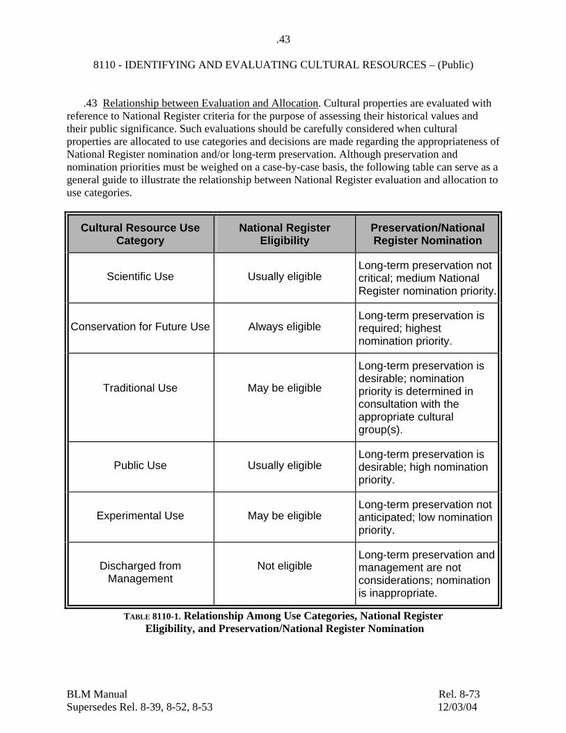
BLM Manual Rel. 8-73 Supersedes Rel. 8-39, 8-52, 8-53 12/03/04
.43 8110 - IDENTIFYING AND EVALUATING CULTURAL RESOURCES – (Public) .43 Relationship between Evaluation and Allocation. Cultural properties are evaluated with reference to National Register criteria for the purpose of assessing their historical values and their public significance. Such evaluations should be carefully considered when cultural properties are allocated to use categories and decisions are made regarding the appropriateness of National Register nomination and/or long-term preservation. Although preservation and nomination priorities must be weighed on a case-by-case basis, the following table can serve as a general guide to illustrate the relationship between National Register evaluation and allocation to use categories.
Cultural Resource Use Category
National Register Eligibility
Preservation/National Register Nomination
Scientific Use Usually eligible Long-term preservation not critical; medium National Register nomination priority.
Conservation for Future Use Always eligible Long-term preservation is required; highest nomination priority.
Traditional Use May be eligible
Long-term preservation is desirable; nomination priority is determined in consultation with the appropriate cultural group(s).
Public Use Usually eligible Long-term preservation is desirable; high nomination priority.
Experimental Use May be eligible Long-term preservation not anticipated; low nomination priority.
Discharged from Management
Not eligible Long-term preservation and management are not considerations; nomination is inappropriate.
TABLE 8110-1. Relationship Among Use Categories, National Register Eligibility, and Preservation/National Register Nomination

BLM Manual Rel. 8-73 Supersedes Rel. 8-39, 8-52, 8-53 12/03/04
.44 8110 - IDENTIFYING AND EVALUATING CULTURAL RESOURCES – (Public) .44 Consultation with Outside Parties A. Consultation with SHPO. In accordance with the national Programmatic Agreement and the State's BLM-SHPO protocol, the Field Office manager should invite the SHPO to participate in developing or revising regional, local and project plans, with regard to cultural property evaluations, allocations to use categories (or revisions to such allocations), identification of objectives, and development of management actions. If evaluations and allocations are jointly agreed to, a major portion of future Section 106 consultation requirements will have been satisfied in advance of specific land use proposals. Evaluations and allocations should be consistent with research and preservation priorities identified in the SHPO’s State Historic Preservation Plan and should consider assessments of significance in any historic contexts that have been developed. B. Consultation with Tribes. Consultation with American Indian tribes and Alaska Native tribes during the inventory and evaluation information-gathering steps is essential for planning purposes and for subsequent compliance with FLPMA, AIRFA, NHPA, ARPA, NAGPRA, and Executive Order 13007. Involving tribal governments closely at this level of resource identification will greatly facilitate coordination and consultation at later stages of planning and project development. (See Manual Section 8100.08C1, Manual Section 8120 and Manual Handbook H-8120-1.)

BLM Manual Rel. 8-73 Supersedes Rel. 8-39, 8-52, 8-53 12/03/04
.5 8110 - IDENTIFYING AND EVALUATING CULTURAL RESOURCES – (Public) .5 Documentation and Maintenance of Data, Records, and Maps .51 Cultural Resource Inventory Records. The BLM cultural resource inventory record system documents cultural properties discovered as a result of field surveys, and traditional cultural properties identified through interviews connected with class III inventories, ethnographic studies, oral testimony, or other sources of reliable information. Such inventories cannot be considered to be complete until the appropriate records (cultural resource record forms, survey records, project reports, maps and photographs) have been developed and sent to the SHPO as specified in BLM/SHPO Protocols developed under the national Programmatic Agreement. The reliability of data on individual cultural properties obtained from non-BLM sources, particularly older data, shall be ascertained before being incorporated fully as part of the system ("recorded"). All inventory information shall be provided to the SHPO promptly in fulfillment of BLM’s data sharing commitments. A. Cultural Resource Record Forms. The basic documentation of adequately recorded cultural properties and traditional cultural properties, as applicable, shall be done with forms and formats acceptable to the appropriate state data repositories in a manner that fulfills the data sharing requirements of the national Programmatic Agreement and data sharing agreements and programs that exist for individual states, and be filed as a permanent part of the Field Office filing system. B. Survey Record. The results of the inventory for each area surveyed must be recorded and the record made a permanent part of the Field Office filing system. These records shall include the nature and intensity of the inventory, both positive and negative results, and appropriate cultural resource record forms, survey notes, project reports, a catalog of curated materials, maps and photographs. Survey records shall be done with forms and formats acceptable to the appropriate state data repositories in a manner that fulfills the data sharing requirements of the national Programmatic Agreement and data sharing agreements and programs that exist for individual states. C. Maps and Photographs. All recorded cultural properties, any traditional cultural concerns that may be represented on maps, and all class II or class III survey units are plotted on scaled maps, preferably using GIS technology, which become a part of the cultural resource inventory record. Photographs and negatives are maintained in proper files, preferably separate from the record forms and cross-keyed to the cultural resource survey record.

BLM Manual Rel. 8-73 Supersedes Rel. 8-39, 8-52, 8-53 12/03/04
.52 8110 - IDENTIFYING AND EVALUATING CULTURAL RESOURCES – (Public)
.52 Maintenance of Inventory and Evaluation Data. A. Paper Files. Each Field Office maintains permanent, up-to-date cultural resource inventory and evaluation records files. At a minimum, the records files include all cultural resource inventory and cultural resource evaluation records prepared for cultural resources and areas inventoried within the relevant administrative unit. B. Digital Data and Automated Files. Each State Director shall cooperate with the SHPO in developing and supporting automated systems for maintaining and utilizing inventory records, and shall ensure that the systems are sufficiently compatible to fulfill the data sharing aims of the national Programmatic Agreement and data sharing agreements and programs that exist for individual states, and also to support the development of BLM GIS based planning and analysis capabilities. .53 Master Maps. Each Field Office will maintain a master set of maps showing all areas surveyed within the administrative unit, the locations of all recorded cultural properties, and any traditional values that can be usefully represented on maps, preferably using GIS technology. Plotted cultural resources are identified by an appropriate reference number acceptable to the appropriate State data repositories in a manner that fulfills the data sharing requirements of the national Programmatic Agreement and data sharing agreements and programs that exist for individual states. .54 Inventory Reports. Each Field Office will maintain a permanent file of all cultural resource inventory reports completed within the administrative unit. .55 Confidentiality. Cultural resource inventory and evaluation records, maps, and reports may be withheld from disclosure to the public as necessary to protect the resource (see Manual Section 8100 Appendix 5, Sec. 304, and Appendix 8, Sec. 9). Each Field Office shall develop procedures related to internal and external GIS data handling and security. .56 Archival Standards. Maintenance of permanent records files, maps, electronic media, and especially photographs, negatives, and slides, should follow archival standards to the extent practical. While it may not be practical to eliminate all possible sources of deterioration, such as fire, humidity, light, and chemical changes, care should be taken not to introduce sources of deterioration when there is a choice. Paper archives should be maintained in an environment conducive to preservation, i.e. temperature and humidity are within acceptable ranges, containers are of an appropriate size and shape, and chemically compatible (folders and sleeves are acid free), and damage from air pollution, light and biological infestations (insects and rodents) is effectively prevented. Digital GIS data records shall be backed up using standard best practice procedures within the computer industry.

BLM Manual Rel. 8-73 Supersedes Rel. 8-39, 8-52, 8-53 12/03/04
.57 8110 - IDENTIFYING AND EVALUATING CULTURAL RESOURCES – (Public) .57 Collections. Artifacts, samples, collections, and copies of records, data, photographs, reports, and other documents resulting from inventory must be housed in an appropriate curatorial facility. Field Office files should maintain a record of artifacts, samples, and collections (which remain the property of the United States), where they are located, and any pertinent curatorial agreement. .58 Inventory Updating. Field Office managers are responsible for ensuring that class I inventories and associated GIS data layers, including survey areas, cultural resource locations and requirements and strategies of unsurveyed areas, are updated often enough to remain fully useful for multiple use decision making.

BLM Manual Rel. 8-73 Supersedes Rel. 8-39, 8-52, 8-53 12/03/04
.6 8110 - IDENTIFYING AND EVALUATING CULTURAL RESOURCES – (Public) .6 External Review. .61 SHPO Review. SHPO review of inventory findings and evaluation recommendations will be determined in each State according to the provisions of the national Programmatic Agreement and State's BLM-SHPO Protocol. As partners in Field Offices’ certification procedures under the national Programmatic Agreement, SHPOs will also be interested in verifying that personnel doing inventory and evaluation work are appropriately professionally qualified (see Manual Section 8100.1 and 2). .62 Tribal Review. Inventory findings and evaluation recommendations resulting from consultation with American Indian tribes and Alaska Native tribes under .44 should be communicated to the tribes, so that they can know how their information was employed and what recommended safeguards will be carried into planning. .63 Peer Review. Field Office managers responsible for cultural resource inventories and evaluations should seek professional peer review as appropriate to ensure quality products. Peer review is especially desirable during historic context or research design development, or other planning and inventory efforts that form the primary substantive and theoretical basis for evaluation and planning. It is also appropriate for planning, implementing, and reporting major inventory or data recovery projects. State and/or regional professional cultural resource associations, universities, and SHPOs are good sources for identifying possible reviewers.

BLM Manual Rel. 8-73 Supersedes Rel. 8-39, 8-52, 8-53 12/03/04
Appendix 1 (.05E; .32A)
8110 - IDENTIFYING AND EVALUATING CULTURAL RESOURCES – (Public)
List of Selected National Register Bulletins
Number Title
15 How to Apply the National Register Criteria for Evaluation
16A How to Complete the National Register Registration Form
16B How to Complete the National Register Multiple Property Documentation Form
18 How to Evaluate and Nominate Designed Historic Landscapes
30 Guidelines for Evaluating and Documenting Rural Historic Landscapes
32 Guidelines for Evaluating and Documenting Properties Associated with Significant Persons
36 Guidelines for Evaluating and Registering Historical Archeological Sites and Districts (Note: also applicable to evaluating and registering prehistoric archaeological sites and districts)
38 Guidelines for Evaluating and Documenting Traditional Cultural Properties
39 Researching a Historic Property
41 Guidelines for Evaluating and Registering Cemeteries and Burial Places
42 Guidelines for Identifying, Evaluating and Registering Historic Mining Properties
Available from the National Register of Historic Places, National Park Service, 1849 C Street, N.W., Washington, D.C. 20240

BLM Manual Rel. 8-73 Supersedes Rel. 8-39, 8-52, 8-53 12/03/04
Appendix 2, Page 1 (.06F; .21C4)
8110 - IDENTIFYING AND EVALUATING CULTURAL RESOURCES – (Public)
Recording Cultural Resource Locations Using Global Position System (GPS) Technology
Purpose and Objective. This guidance describes minimum requirements for recording BLM cultural resource locations using GPS technology. The BLM has required the use of GPS to record all cultural resource locations since April 1, 2004. The GPS has become a major tool both for traditional mapping applications and for Geographic Information System (GIS). The main objective of this guidance is to improve the overall reliability of site location information recorded by cultural resource specialists, including cooperators, contractors, and permittees; and to support the standardization and expansion of GIS applications for cultural resource management. Accuracy Standard. The accuracy standard for cultural resource location data shall be a mean error of +/-12.5 meters or less, at a 95 percent confidence level. This mean error requirement is consistent with the National Map Accuracy Standard for 1:24,000 scale quadrangles and Federal Geographic Data Committee (FGDC) reporting requirements. This degree of accuracy can be achieved with a variety of contemporary GPS equipment. Appropriate equipment is defined as GPS technology that meets the accuracy standard. Field Observation Standards – GPS. Cultural resources shall be located by reporting a minimum of one GPS-observed coordinate taken in the approximate estimated visible center (centroid) of the resource. The centroid need not be perfectly central to a site, but it must lie in the site’s approximate center for map-plotting purposes. Multiple coordinates shall be used to define the approximate centerline of a linear resource (e.g., trail), if field judgment suggests that a single centroid is insufficient to record its location. More points, lines or polygons may be taken for other mapping purposes, including recording project area boundaries, site datums or markers, or internal attributes. Applicability of this standard for recording isolated finds shall be a State-level decision. Field Observation Standards – UTM. In addition, cultural resource locations shall be reported using the Universal Transverse Mercator (UTM) coordinate system, North American Datum 1983 (NAD83). This is the same standard used for the National Register of Historic Places. A State Historic Preservation Office may also request that locations be reported in a State-specific coordinate system. Consequently, it is important that all reported coordinates clearly identify the coordinate system used. Alternative Field Observation Methods. In situations where GPS observations are not practical or possible due to geography, vegetation, satellite availability, or the presence of hazardous materials, the recorder should locate the resource using GPS offset equipment and capabilities, map coordinates, or a combination of GPS and other techniques. Such non-GPS methods must be described in the site or project area record.

BLM Manual Rel. 8-73 Supersedes Rel. 8-39, 8-52, 8-53 12/03/04
Appendix 2, Page 2 (.06F; .21C4)
8110 - IDENTIFYING AND EVALUATING CULTURAL RESOURCES – (Public) Recording Standard: The location observations shall be reported on the appropriate part of a resource recording form, in the narrative description of the resource, or both, and shall include the following information:
• The UTM coordinates with the UTM zone. For all coordinates, the datum reference must be reported.
• The coordinate system for observations should be recorded in an obvious way (e.g. "UTM Zone 10 NAD83 centroid coordinate: N4986000 E302000 meters")
• The probable error must also be recorded in narrative, if the error terms for a given coordinate are known (e.g., "GPS observations were differentially processed to an average error of less than 5m root mean standard deviation [RMS]").
• Receiver type, correction status, length of observation and number of observation points, position dilution of precision (PDOP), and horizontal error estimates must be recorded with the location whenever GPS equipment and software provides such information.
• Discrepancies between GPS locations and USGS quadrangle locations should be noted on the site record. Because GPS locations are mathematically precise coordinates, a point plotted from GPS may appear to be in an incorrect location on a USGS quadrangle.
Standards may be exceeded. These are minimum standards and should not be used to lessen any applicable State or Federal standard or reduce site location accuracy from conventional mapping methods. There may be situations where more accurate location information is desirable or required. For instance, State Offices may apply more stringent standards for intra-site mapping, excavation unit and datum locations. In all instances, the most accurate and capable equipment available shall be used to meet the needs of the types of data that are being recorded, even if it exceeds the accuracy standards in this guidance. Appropriate GPS experts within Washington Office, National Centers, State and Field Offices should be consulted as needed.