DEPARTMENT OF THE ARMY - lrb.usace.army.mil · if, in the opinion of the Secretary of the Army or...
18
DEPARTMENT OF THE ARMY BUFFALO DISTRICT, CORPS OF ENGINEERS 1776 NIAGARA STREET BUFFALO, NEW YORK 14207-3199 DEPARTMENT OF THE ARMY PERMIT Permittee: Stephen H. Bales Lieutenant Colonel, Corps of Engineers District Engineer On Behalf of the General Public Permit No.: 86-000-1 Processing No.: Effective Date: November 4, 2011 Expiration Date: November 4, 2016 Affirmation Date: Issuing Office: U.S. Army Engineer District, Buffalo 1776 Niagara Street Buffalo, New York 14207-3199 IMPORTANT: Please note that written affirmation from this office is required prior to commencing the activity authorized by this permit as outlined in the General Permit Notification Requirements on pages 2 and 3 . Otherwise this permit is available for use without pre- construction notification to this office, provided all parties read, understand, and comply will all terms and conditions of this permit. Non-compliance with any of the terms or conditions may result in an order to remove the activity; civil and/or criminal penalties or both. AUTHORITIES: You have been authorized to undertake the activity described below pursuant to: Section 10 of the Rivers and Harbors Act of 1899 (33 U.S.C. 403) and Section 404 of the Clean Water Act (33 U.S.C. 1344) AUTHORIZED ACTIVITY: Construct stone filled timber crib dock(s), boat/jet ski hoist(s), and covered (not enclosed) boat slip(s) and hoist(s).
Transcript of DEPARTMENT OF THE ARMY - lrb.usace.army.mil · if, in the opinion of the Secretary of the Army or...

DEPARTMENT OF THE ARMY BUFFALO DISTRICT, CORPS OF ENGINEERS 1776 NIAGARA STREET BUFFALO, NEW YORK 14207-3199
DEPARTMENT OF THE ARMY PERMIT Permittee: Stephen H. Bales Lieutenant Colonel, Corps of Engineers District Engineer On Behalf of the General Public Permit No.: 86-000-1 Processing No.: Effective Date: November 4, 2011 Expiration Date: November 4, 2016 Affirmation Date: Issuing Office: U.S. Army Engineer District, Buffalo 1776 Niagara Street Buffalo, New York 14207-3199 IMPORTANT: Please note that written affirmation from this office is required prior to commencing the activity authorized by this permit as outlined in the General Permit Notification Requirements on pages 2 and 3. Otherwise this permit is available for use without pre-construction notification to this office, provided all parties read, understand, and comply will all terms and conditions of this permit. Non-compliance with any of the terms or conditions may result in an order to remove the activity; civil and/or criminal penalties or both. AUTHORITIES: You have been authorized to undertake the activity described below pursuant to:
Section 10 of the Rivers and Harbors Act of 1899 (33 U.S.C. 403)
and
Section 404 of the Clean Water Act (33 U.S.C. 1344) AUTHORIZED ACTIVITY: Construct stone filled timber crib dock(s), boat/jet ski hoist(s), and covered (not enclosed) boat slip(s) and hoist(s).

-2-
LOCATION OF THE AUTHORIZED ACTIVITY: Waters of the United States that are located within the State of New York and subject to regulation by the U.S. Army Engineer District, Buffalo. The general public is hereby authorized by the Secretary of the Army to perform the work authorized by this permit provided the following general and special conditions are fully complied with. The District Commander reserves the right to include any additional special conditions or require an individual permit as may be necessary to safeguard the public interest or protect important public resources on a case by case basis. NOTE: When the property associated with the work authorized by this permit is sold or transferred, the terms and conditions of this permit will continue to be binding on the new owner(s) of the property. To validate the transfer of this permit and the liabilities associated with compliance with its terms and conditions, have the transferee sign and date on the last page of this permit and forward a copy of the permit to this office to validate the transfer of this authorization. DEFINITIONS: The term "you" and its derivatives, as used in this permit, mean the permittee or any future transferee. The term "this office" refers to the Buffalo District Corps of Engineers Regulatory office having jurisdiction over the permitted activity or the appropriate official of that office acting under the authority of the commanding officer. The term "activity" as used in this permit includes all structures and work authorized by this permit. Navigable waters (as regulated under Section 10 of the Rivers and Harbors Act) - Those waters that are subject to the ebb and flow of the tide and/or are presently used, or have been used in the past, or may be susceptible for use to transport interstate or foreign commerce. A determination of navigability, once made, applies laterally over the entire surface of the waterbody, and is not extinguished by later actions or events which impede or destroy navigable capacity. A list of navigable waters in the Buffalo District can be found on the Buffalo District web site at http://www.lrb.usace.army.mil/Missions/Regulatory/DistrictInformation/NavigableWaterways, or by calling (716) 879-4330. Ordinary High Water Mark - The line on the shore established by the fluctuations of water as indicated by physical characteristics such as a clear, natural line impressed on the bank, shelving, changes in the character of the soil, destruction of terrestrial vegetation, the presence of litter and debris, or other appropriate means that consider the characteristics of the surrounding areas. GENERAL PERMIT NOTIFICATION REQUIREMENTS: The special condition section identifies which activities do or do not require written verification of the applicability of this general permit from the Buffalo District prior to commencement of the work.

-3-
If your activity DOES NOT require notification and subsequent authorization from the Buffalo District, and you meet all of the terms and conditions of this permit, you may proceed with your work. Within 30 days of the completion of the work authorized by this permit, you are required to submit project drawings (including location map and plan view diagram) and the attached compliance certification form to the Buffalo District office. For projects that DO require notification to the Buffalo District prior to commencement of the work, the following information must be submitted with the New York State Department of Environmental Conservation / U.S. Army Corps of Engineers joint application for permit: 1. Name, address and telephone number of the applicant. 2. Location map identifying project site. 3. A brief project description. 4. Project plans depicting proposed work. Pre-construction notification and written affirmation from this office of the applicability of this permit is required for the following: any variances noted in the conditions below; work in wetlands; projects in areas designated as erosion hazard areas as noted in Special Condition No. 18; projects not meeting the requirements to isolate the work area identified in Special Condition No. 19; projects requiring coastal zone consistency as required in Special Condition No. 21; projects located in sensitive areas, as noted in Special Condition No. 22; projects that may have the potential to affect historic resources, as described in Special Condition No. 23; and for projects located within a component of the National Wild and Scenic Rivers (NWSR) System as noted in Special Condition No. 24. GENERAL CONDITIONS: 1. The installation of the permitted structure and fills authorized under this regional permit must be completed prior to the expiration date noted on the first page of this authorization. In the event that the affirmation date is less than twelve months prior to the expiration date, the regional permit will remain valid for a period of twelve months from the affirmation date. In no case shall authorization exceed twelve months beyond the expiration date. If you find that you need more time to begin and/or complete the authorized activity, submit your written request for a time extension to this office at least 30 days before the respective date(s) 2. You must maintain the structures and fills authorized by this permit in good condition and in conformance with the terms and conditions of this permit. You are not relieved of this requirement if you abandon the permitted structure, unless you make a good faith transfer to a third party in accordance with requirements noted below. Should you wish to cease to maintain the authorized activity or should you desire to abandon it without a good faith transfer, you may be required to remove the structure(s) and restore the site to its original pre-project conditions. 3. If you discover any previously unknown historic or archaeological remains while accomplishing the activity authorized by this permit, you must immediately notify this office of what you have found. We will initiate the Federal and State coordination required to determine if

-4-
the remains warrant a recovery effort or if the site is eligible for listing in the National Register of Historic Places. 4. You must allow representatives from this office to inspect the authorized activity at any time deemed necessary to ensure that it is being or has been accomplished in accordance with the terms and conditions of your permit. 5. The permittee understands and agrees that, if future operations by the United States require the removal, relocation, or other alteration, of the structure or work herein authorized, or if, in the opinion of the Secretary of the Army or his authorized representative, said structure or work shall cause unreasonable obstruction to the free navigation of the navigable waters, the permittee will be required, upon due notice from the Corps of Engineers, to remove, relocate, or alter the structural work or obstructions caused thereby, without expense to the United States. No claim shall be made against the United States on account of any such removal or alteration. 6. This office reserves the right to use this regional permit in combination with any existing or future nationwide, regional or individual permit or any letter of permission. SPECIAL CONDITIONS: 1. The authorized structure must not interfere with the public's right to free navigation on all navigable waters of the United States (see 33 CFR 322.5(d)). 2. All structures authorized by this permit must be set back a minimum of 10 feet from the common boundary line of adjoining properties that are under separate ownership. The setback is measured at the point where the common boundary terminates at the Ordinary High Water shoreline. A variance in this distance may be granted where there are natural limiting features or limited shoreline available and coordination with adjacent property owner(s) has occurred. All variances must be approved by this office on a case by case basis. Note that the dispute over property ownership will not be a factor in the Corps public interest decision (see 33 CFR 320.4(g)). 3. Structures authorized by this permit shall not extend waterward more than 100 feet from the Ordinary High Water (OHW) shoreline or 20 percent of the waterway width, whichever is less. The waterway width is measured from the Ordinary High Water shoreline perpendicular to the centerline of the waterway. 4. A variance in the maximum offshore distance of a structure may be granted in cases where conformity with existing structures would be practical, where exceptions would be reasonable due to the shoreline configuration, or for structures crossing shoals, wetlands or other special aquatic sites. 5. Configuration of dock(s) may vary in plan (i.e. straight, T or L shaped) provided the total length of all segments and separate structures does not exceed 150 feet and the surface area of the dock(s), including finger piers, deck, platform, etc. does not exceed 1200 square feet. Docks parallel to and along the shoreline are not permitted by this Regional Permit, unless a variance is
-5-
granted. A variance may be granted in cases where exceptions would be reasonable due to the topography of the shoreline, or for navigational reasons. The dock(s) shall not exceed 8 feet in width. 6. Multiple docks, extensions to existing docks, and/or docks with a deck or platform are authorized by this permit provided that the proposed and all existing structures, if any, are within the size limitations specified in this permit, for each property. Note: For the purposes of this Regional Permit, a deck is any portion of the dock that exceeds 8 feet in width. See Special Condition No. 20 for additional requirements on multiple docks located in the Coastal Zone Management area. 7. Regular or irregular shaped configurations (i.e. dock[s] with a deck) are allowed in the middle or at the waterward terminus of the structure provided the surface area of the deck does not exceed 200 square feet. A variance to this condition (i.e., shoreline deck) may be granted in cases where exceptions would be reasonable due to the topography of the shoreline, or for navigational reasons. All variances must be approved by this office on a case by case basis. Only one deck per property is authorized by this permit. 8. The total surface area of all boat and jet ski hoist(s) and covered boat slip(s) shall not exceed 900 square feet. 9. Crib supports must be timber filled with stone. Crib supports constructed of steel or concrete caissons filled with concrete or culverts filled with concrete are not authorized by this permit. The sides of the cribs shall not be sealed and must have openings amounting to at least 40 percent of the peripheral area of the crib. Fill placed in the cribs must be clean stone large enough so as not to pass through the crib openings. The shoreward support or footer for the dock shall be placed above the Ordinary High Water shoreline. A variance in the location of the first crib may be granted in cases where the shoreline configuration or rock outcropping prevents placement of the dock support or footer above the Ordinary High Water shoreline. A variance may also be granted when the shoreward crib is part of an existing structure and this permit is being used for a dock extension.Variance requests must state the particular reason(s) for the requests including site specific information (i.e., site photos) in support of the request. 10. The total length of all cribs must not exceed 50 percent of the total length of each dock. The length of individual cribs must not exceed 10 feet in Lakes Erie and Ontario or the Niagara and St. Lawrence Rivers; and 8 feet in all other water bodies. The dimensions of the individual cribs may vary, but must not exceed 64 square feet. 11. Dock(s) may cross wetland provided that cribs are not located in wetland areas. Pre-construction notification and written affirmation from this office of the applicability of this permit is required for all activities in wetlands. The dock segment crossing a wetland area must be pile supported, and must not exceed 4 feet in width. The underside of the dock must also be a minimum of 4 feet above the ground surface. During the evaluation of applications for dock(s) in wetland areas consideration will be given to the size and type of the wetland area and the existence of other structures. Any proposal that would result in fragmentation of the contiguous

-6-
wetlands or essentially overcrowd the wetland with docks and related human activity so as to adversely impact the functions and values of the wetland will not be authorized by this regional permit. 12. To the maximum extent practicable, dock(s) shall cross wetlands so that dredging for access to the dock is not required. If dredging is required, separate authorization must be obtained. If separate authorization is requested, this permit can only be used to authorize the dock when the dredge area is limited to the minimum amount necessary to provide access to the dock. The minimum amount necessary may vary from site to site but should generally not exceed a channel 15 feet in width. 13. Side staving, if used, shall not extend lower than one half of the distance between the Ordinary High and Low Water levels. In addition, the top of the dock must be a minimum of one foot above the Ordinary High Water elevation. 14. Use of creosote treated wood is prohibited in New York State. All treated wood must be aged in the open air for at least three months prior to in-water use. Wood must be clean and free of surface deposits. Timber with surface deposits must be washed for at least five minutes under running water prior to use. Any wood debris, such as sawdust or wash water, must not enter any water body including wetlands. This washing must occur more than 100 feet from a wetland or waterbody. For more information, contact the applicable New York State Department of Environmental Conservation regional office and U.S. Environmental Protection Agency regional office. 15. Where necessary, dredging is limited to the minimum amount necessary for crib placement and shall not exceed a total of 20 cubic yards. Dredged stone that meets the criteria specified in Special Condition No. 9 may be used in the cribs. All other dredged material must be deposited on upland property and stabilized to prevent reentry into waters of the United States, including wetlands. 16. All in-water work shall be restricted to dates that will preclude the adverse impacts to indigenous fish species. It is the applicant’s responsibility to obtain these dates from the appropriate NYSDEC regional office and the NYS Department of State if applicable. (See attached map for NYSDEC contact information) 17. This permit does not authorize work on barrier beaches when it is determined by the District Engineer that the work would adversely impact a barrier beach. 18. This permit does not authorize work in areas designated as erosion hazard areas, unless a permit is obtained under the New York Coastal Erosion Hazard Area Act (Article 34 of the Environmental Conservation Law). Permits are administered by the New York State Department of Environmental Conservation (NYSDEC), municipality, or county. Pre-construction notification and written affirmation from this office of the applicability of this permit is required for all activities in areas designated as erosion hazard areas.

-7-
19. In order to maintain water quality conditions, any dock construction must include provisions for isolating the work area. This permit is conditioned to require work in the dry, the use of silt curtains or similar protective measures to avoid or contain turbidity. Pre-construction notification and written affirmation from this office of the applicability of this permit is required for all activities not meeting this condition. 20. The New York State Department of Environmental Conservation has denied Section 401 Water Quality Certification for the activities authorized by this permit. You must obtain an individual Water Quality Certification from the NYS Department of Environmental Conservation. (See attached map for NYSDEC contact information) 21. You must obtain a consistency concurrence from the New York State Department of State (NYS DOS) for multiple docks located within the entire Coastal Zone Management (CZM) area and for all activities located within a New York State Significant Coastal Fish & Wildlife Habitat (SCFWH) and/or within an area with a federally approved Local Waterfront Revitalization Program (LWRP). For assistance with identifying as to whether the activity is located within one of these special management areas, please visit http://nyswaterfronts.com/consistency_federal.asp or contact NYS DOS. Pre-construction notification and written affirmation from this office of the applicability of this permit is required for any project requiring consistency review by the NYS DOS. No work shall be started under this permit until the concurrence has been secured or the State has failed to act on the submitted consistency certification within six months, beginning from the date the submission is determined by NYS DOS to be complete. You must comply with all conditions of your individual consistency concurrence. In the event that the NYS DOS objects to your consistency certification, no work shall be performed under this permit. See below under AGENCY COORDINATION REQUIREMENTS for additional information. 22. Endangered Species: Pre-construction notification and written affirmation from this office of the applicability of this permit is required for activities located within sensitive areas, as identified on Table 1. For activities that are proposed to occur within these sensitive areas, the application must include a discussion of potential threatened and endangered species (T&E) habitat within the project site. Refer to the USFWS T&E website at http://www.fws.gov/northeast/nyfo/es/section7.htm for information on habitat requirements for listed species. If there is potential habitat for any federally listed species within the project site:
1) send the results of any habitat surveys 2) include a detailed description of the proposed project, including approximate
proposed project construction schedule and project activities (e.g., land clearing, utilities, stormwater management).
3) include a description of the natural characteristics of the property and surrounding area (e.g., forested areas, freshwater wetlands, open waters, and soils). Additionally, please include a description of surrounding land use (residential, agricultural, or commercial).
4) provide a description of the area to be impacted by the proposed project, including trees to be removed.
5) provide a description of conservation measures to avoid or minimize impacts to listed species.

-8-
Applicants shall not commence work in these townships, waterways, or locations under this permit until the requirements of the Endangered Species Act have been satisfied and the applicant receives written verification that the work may proceed. Note that as a result of consultation with the USFWS, the District Engineer may add species-specific conditions to the permit. 23. Cultural Resources: Pre-construction notification (PCN) and written affirmation from this office of the applicability of this permit is required for activities which may have the potential to cause effects to any historic properties listed, determined to be eligible for listing on, or potentially eligible for listing on the National Register of Historic Places, including previously unidentified properties. In order for the Buffalo District to determine if National Historic Preservation Act Section 106 consultation is required, all PCNs must include a written statement indicating if any properties listed or eligible for listing, in the National Register of Historic Places may be affected by the proposed project. A copy of any completed survey reports shall be provided with the PCN. If a survey has not been performed then the statement shall include a list of resources checked in the determination. Copies of any available correspondence from NYS Office of Parks, Recreation, and Historic Preservation (SHPO) regarding historic properties shall be provided with the PCN. Information regarding cultural resources may be found at: http://parks.ny.gov/shpo/. Assistance regarding information on the location of or potential for the presence of historic resources can be sought from the State Historic Preservation Officer or Tribal Historic Preservation Officer (THPO), as appropriate, and the National Register of Historic Places (see 33 CFR 330.4(g)). Based on the information submitted and these efforts, the district engineer shall determine whether the proposed activity has the potential to cause an effect on the historic properties. Where the applicant has identified historic properties which the activity may have the potential to cause effects and so notified the Corps, the applicant shall not begin the activity until notified by the district engineer either that the activity has no potential to cause effects or that consultation under Section 106 of the NHPA has been completed. Prospective permittees should be aware that section 110k of the NHPA (16 U.S.C. 470h-2(k)) prevents the Corps from granting a permit or other assistance to an applicant who, with intent to avoid the requirements of Section 106 of the NHPA, has intentionally significantly adversely affected a historic property to which the permit would relate, or having legal power to prevent it, allowed such significant adverse effect to occur, unless the Corps, after consultation with the Advisory Council on Historic Preservation (ACHP), determines that circumstances justify granting such assistance despite the adverse effect created or permitted by the applicant. If circumstances justify granting the assistance, the Corps is required to notify the ACHP and provide documentation specifying the circumstances, explaining the degree of damage to the integrity of any historic properties affected, and proposed mitigation. This documentation must include any views obtained from the applicant, SHPO/THPO, appropriate Indian tribes if the undertaking occurs on or affects historic properties on tribal lands or affects properties of interest to those tribes, and other parties known to have a legitimate interest in the impacts to the permitted activity on historic properties. 24. Pre-construction notification and written affirmation from this office of the applicability of this permit is required for all activities located within a component of the National Wild and Scenic Rivers (NWSR) System, or on rivers currently being studied at the direction of Congress as potential additions to the NWSR System, or rivers for which Wild and
-9-
Scenic Rivers studies have been completed and forwarded to Congress and which Congress is still considering. The portion of the Genesee River located within Letchworth Gorge State Park, beginning at the southern boundary of the park and extending downstream to the Mt. Morris Dam, was designated by Congress as a permanent Study River in the Genesee River Protection Act of 1989. No activity may occur within a NWSR, including Study Rivers, unless the National Park Service (NPS) has determined in writing that the proposed work will not adversely affect the NWSR designation or study status. In addition, pre-construction notification and written affirmation from this office of the applicability of this permit is required for all activities located within areas listed in the Nationwide Rivers Inventory (list is available at: http://www.nps.gov/ncrc/programs/rtca/nri/states/ny.html). Activities located in the above areas will be evaluated on a case by case basis, which will include coordination with the National Park Service.
AGENCY COORDINATION REQUIREMENTS: 1. You must furnish the New York State Department of State (NYS DOS) with a copy of the preconstruction notification, a signed copy of the Federal Consistency Assessment Form (FCAF) and policy analysis (available at: http://nyswaterfronts.com/downloads/pdfs/fcaf2.pdf), project drawings, recent color photographs and all supporting information as described in D. 2 of the FCAF for the following activities:
-all activities located within New York State Significant Coastal Fish & Wildlife Habitat Areas; - for multiple docks located within the entire Coastal Zone Management area; -and all activities located within a federally approved Local Waterfront Revitalization Program. Electronic submissions can be made by e-mailing all of the above mentioned information to NYS DOS at: [email protected] . Hard copies of submissions should be forwarded to:
NYS Department of State Division of Coastal Resources Consistency Review Unit One Commerce Plaza 99 Washington Ave. Albany, NY 12231-0001 Telephone (518) 474-6000
In addition, you must furnish the District Engineer, Buffalo District, with a copy of the consistency concurrence letter or a dated copy of the Federal Consistency Assessment Form that you provided to the NYSDOS.
2. The New York State Department of Environmental Conservation has denied Section 401 Water Quality Certification for the activities authorized by this permit. You must obtain an individual Water Quality Certification from the NYS Department of Environmental Conservation. (See attached map for NYSDEC contact information)
3. Prior to or immediately following construction of the dock(s) authorized by this permit you shall contact the U.S. Coast Guard to determine if any safety lights or signals are required. If

-10-
directed by the U.S. Coast Guard, you shall install and maintain these devices at your expense. The U.S. Coast Guard can be reached by calling (216) 902-6066 or by writing to: Commander (OAN) Ninth Coast Guard District ATTN: Private Aids to Navigation 1240 East Ninth Street Cleveland, Ohio 44199-2060 EXCLUSIONS: This permit does not apply to: 1. In cases where the District Engineer determines that the activity may affect properties listed, or eligible for listing, in the National Register of Historic Places, the activity is not authorized, until the requirements of Section 106 of the National Historic Preservation Act (NHPA) have been satisfied. 2. Any other areas named in Acts of Congress or Presidential Proclamations as National Wilderness Areas, National Recreational Areas, Lakeshores, Parks, Monuments and such areas as may be established under Federal Law for similar and related purposes, such as estuaries and marine sanctuaries, except where specifically authorized by this regional permit. 3. Structures and/or fills which may jeopardize the continued existence of species listed as endangered or threatened under the Endangered Species Act (ESA) of 1973, as amended, or result in the likelihood of the destruction or adverse modification of a habitat which is determined by the Secretary of the Interior or Commerce, as appropriate, to be a critical habitat under the Endangered Species Act of 1973, as amended. No activity is authorized under this Regional Permit which is likely to jeopardize the continued existence of a threatened or endangered species or a species proposed for such designation, as identified under the Federal Endangered Species Act, or which will destroy or adversely modify the Critical Habitat of such species. Authorization of an activity by this Regional Permit does not authorize the 'take' of a threatened or endangered species as defined under the ESA. In absence of separate authorization (E.G., an ESA Section 10 Permit, a Biological Opinion with 'incidental take' provisions, etc.) from the U.S. Fish and Wildlife Service, both lethal and non-lethal 'takes' of protected species are in violation of the ESA. 4. This permit does not authorize the placement of enclosed buildings, boathouses, fuel storage tanks, sinks, toilets, showers, fuel dispensing or sanitary pump-out facilities on any dock(s) waterward of the Ordinary High Water shoreline. LIMITS OF THIS AUTHORIZATION: 1. The granting of this permit does not obviate the need to obtain other Federal, State or local authorizations as required by law. Specifically, a permit pursuant to the Environmental

-11-
Conservation Law Articles 15, 24 or 34 may be required from the New York State Department of Environmental Conservation. 2. Issuance of this permit does not grant you any property rights or exclusive privileges, nor does it authorize any injury to the property or rights of others. 3. This permit does not authorize interference with any existing or proposed Federal project, nor does it convey any authority to interfere with the right of the public to free navigation on all navigable waters of the United States. LIMITS OF FEDERAL LIABILITY: In issuing this permit, the Federal Government does not assume any liability for the following: 1. Damages to the permitted project or uses thereof as a result of other permitted or unpermitted activities or from natural causes. 2. Damages to the permitted project or uses thereof as a result of current or future activities undertaken by or on behalf of the United States in the public interest. 3. Damages to persons, property, or to other permitted or unpermitted activities or structures caused by the activity authorized by this permit. 4. Design or construction deficiencies associated with the permitted work. 5. Damages associated with any future modification, suspension, or revocation of this permit. RELIANCE ON APPLICANT'S DATA: The determination of this office that issuance of this permit is not contrary to the public interest was made in reliance on the information you provided. RE-EVALUATION OF THE DECISION TO GRANT A REGIONAL PERMIT: This office may re-evaluate its decision on this permit at any time circumstances warrant. Circumstances that could require a re-evaluation include, but are not limited to, the following: 1. You fail to comply with the terms and conditions of this permit. 2. The information provided by you in support of your application proves to have been false, incomplete, or inaccurate. 3. Significant information surfaces which this office did not consider in reaching the original public interest decision. Such a re-evaluation may result in a determination that it is appropriate to use the suspension, modification, and revocation procedures contained in Title 33 of the Code of Federal Regulations

-12-
Part 325.7 or enforcement procedures such as those contained in Title 33 of the Code of Federal Regulations Parts 326.4 and 326.5. The referenced enforcement procedures provide for the issuance of an administrative order requiring you to comply with the terms and conditions of your permit and for the initiation of legal action where appropriate. You will be required to pay for any corrective measures ordered by this office, and if you fail to comply with such directive, this office may, in certain situations (such as those specified in Title 33 of the Code of Federal Regulations Part 209.170) accomplish the corrective measures by contract or otherwise and bill you for the cost. EXTENSIONS: General Condition 1 establishes a time limit for the completion of the activity authorized by this permit. Unless there are circumstances requiring either a prompt completion of the authorized activity or a re-evaluation of the public interest decision, the Corps will normally give favorable consideration to a request for an extension of this time limit. Extension requests must be submitted in accordance with the directions given in General Condition 1. BY AUTHORITY OF THE SECRETARY OF THE ARMY: Copy of Signed Original Available Upon Request District Engineer __________________________________ Date When the property associated with the work authorized by this permit is sold or transferred, the terms and conditions of this permit will continue to be binding on the new owner(s) of the property. To validate the transfer of this permit and the liabilities associated with compliance with its terms and conditions, you must obtain the signature of the new owner in the space provided and forward a copy of the permit to this office to validate the transfer of this authorization. __________________________________ Transferee __________________________________ Date

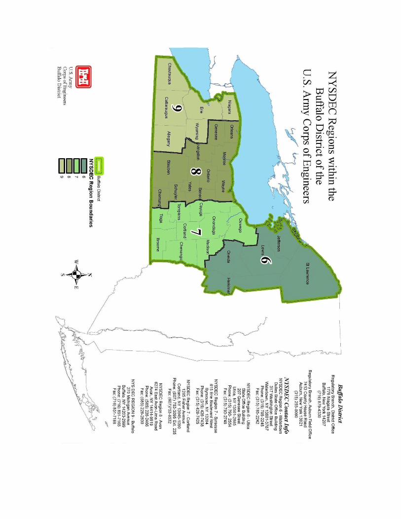
Table 1. Locations of Federally-Listed Threatened and Endangered Species and Candidate Species that may be affected by Regional Permits 79-000-3, 81-000-1, 86-000-1, 87-000-1, and 87-000-13 in waters of the U.S. within the State of New York and subject to regulation by the U.S. Army Engineer District, Buffalo, under Section 404 of the Clean Water Act 1977 (33 U.S.C. 1344) and the Rivers and Harbors Act of 1899. This table is effective as of May 2015.
County Townships/Watershed Species/Status/and or Critical Habitat
Avoidance Action Code1
Allegany All Towns, for projects with proposed tree removal
Northern long-eared bat (Threatened)
2
Broome All Towns, for projects with proposed tree removal
Northern long-eared bat 2
Cattaraugus HUCs 05010001 and 05010002 (Allegheny River, Cassadaga and Conewango Creek basin.)
Clubshell, Rayed bean (Endangered)
1
All Towns, for projects with proposed tree removal
Northern long-eared bat 2
Cayuga Projects in wetlands in all Towns where project is at elevation < 1,000 ft
Bog turtle (Threatened) 1
All Towns, elevation under 900’ Indiana bat (Endangered) 2
All Towns, for projects with proposed tree removal
Northern long-eared bat 2
Chautauqua HUCs 05010001, 05010002, and 05010004 (Allegheny River, Cassadaga and Conewango Creek basin.)
Clubshell, Rayed bean 1
All Towns, for projects with proposed tree removal
Northern long-eared bat 2
Chemung All Towns, for projects with proposed tree removal
Northern long-eared bat 2
Chenango All Towns, for projects with proposed tree removal
Northern long-eared bat 2
Cortland All Towns, for projects with proposed tree removal
Northern long-eared bat 2
Erie All Towns, for projects with proposed tree removal
Northern long-eared bat 2
Genesee Projects in wetlands in all Towns where project is at elevation < 1,000 ft.
Bog turtle, Houghton’s goldenrod (Threatened), Eastern massasauga (Candidate)
1
All Towns, for projects with proposed tree removal
Northern long-eared bat 2
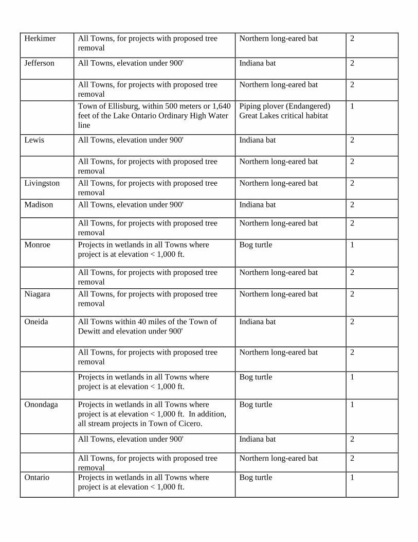
Herkimer All Towns, for projects with proposed tree removal
Northern long-eared bat 2
Jefferson All Towns, elevation under 900' Indiana bat 2
All Towns, for projects with proposed tree removal
Northern long-eared bat 2
Town of Ellisburg, within 500 meters or 1,640 feet of the Lake Ontario Ordinary High Water line
Piping plover (Endangered) Great Lakes critical habitat
1
Lewis All Towns, elevation under 900' Indiana bat 2
All Towns, for projects with proposed tree removal
Northern long-eared bat 2
Livingston All Towns, for projects with proposed tree removal
Northern long-eared bat 2
Madison All Towns, elevation under 900' Indiana bat 2
All Towns, for projects with proposed tree removal
Northern long-eared bat 2
Monroe Projects in wetlands in all Towns where project is at elevation < 1,000 ft.
Bog turtle 1
All Towns, for projects with proposed tree removal
Northern long-eared bat 2
Niagara All Towns, for projects with proposed tree removal
Northern long-eared bat 2
Oneida All Towns within 40 miles of the Town of Dewitt and elevation under 900'
Indiana bat 2
All Towns, for projects with proposed tree removal
Northern long-eared bat 2
Projects in wetlands in all Towns where project is at elevation < 1,000 ft.
Bog turtle 1
Onondaga Projects in wetlands in all Towns where project is at elevation < 1,000 ft. In addition, all stream projects in Town of Cicero.
Bog turtle 1
All Towns, elevation under 900' Indiana bat 2
All Towns, for projects with proposed tree removal
Northern long-eared bat 2
Ontario Projects in wetlands in all Towns where project is at elevation < 1,000 ft.
Bog turtle 1

All Towns, for projects with proposed tree removal
Northern long-eared bat 2
Orleans Projects in wetlands in all Towns where project is at elevation < 1,000 ft.
Bog turtle 1
All Towns, for projects with proposed tree removal
Northern long-eared bat 2
Oswego Projects in wetlands in all Towns where project is at elevation < 1,000 ft.
Bog turtle 1
All Towns, elevation under 900' Indiana bat 2
All Towns, for projects with proposed tree removal
Northern long-eared bat 2
Sandy Creek and Richland, within 500 meters or 1,640 feet of the Lake Ontario Ordinary High Water line
Piping plover Great Lakes critical habitat
1
St. Lawrence All Towns within 40 miles of Watertown, and elevation under 900’
Indiana bat 2 All Towns, for projects with proposed tree
removal Northern long-eared bat 2
Schuyler Dix, along west side of Seneca Lake Leedy’s roseroot (Threatened) 1
All Towns, for projects with proposed tree removal
Northern long-eared bat 2
Seneca Projects in wetlands in all Towns where project is at elevation < 1,000 ft.
Bog turtle 1
All Towns within 40 miles of Town of Dewitt and elevation under 900’
Indiana bat 2
All Towns, for projects with proposed tree removal
Northern long-eared bat 2
Steuben All Towns, for projects with proposed tree removal
Northern long-eared bat 2
Tioga All Towns, for projects with proposed tree removal
Northern long-eared bat 2
Tompkins Projects in wetlands in all Towns where project is at elevation < 1,000 ft.
Bog turtle 1
All Towns, for projects with proposed tree removal
Northern long-eared bat 2
Wayne Projects in wetlands in all Towns where project is at elevation < 1,000 ft.
Bog turtle 1
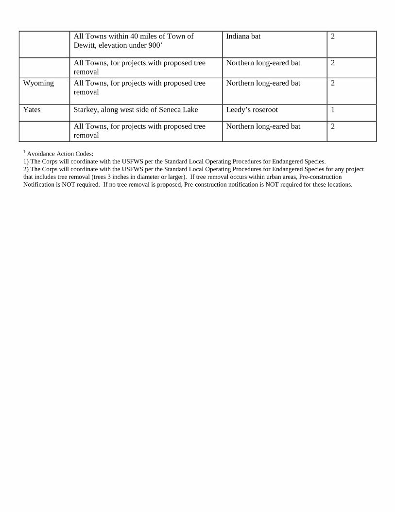
All Towns within 40 miles of Town of Dewitt, elevation under 900’
Indiana bat 2
All Towns, for projects with proposed tree removal
Northern long-eared bat 2
Wyoming All Towns, for projects with proposed tree removal
Northern long-eared bat 2
Yates Starkey, along west side of Seneca Lake Leedy’s roseroot 1
All Towns, for projects with proposed tree removal
Northern long-eared bat 2
1 Avoidance Action Codes: 1) The Corps will coordinate with the USFWS per the Standard Local Operating Procedures for Endangered Species. 2) The Corps will coordinate with the USFWS per the Standard Local Operating Procedures for Endangered Species for any project that includes tree removal (trees 3 inches in diameter or larger). If tree removal occurs within urban areas, Pre-construction Notification is NOT required. If no tree removal is proposed, Pre-construction notification is NOT required for these locations.

IMPORTANT
This form must be completed and mailed to the District Commander upon completion of any work authorized by Department of the Army Permit No. 86-000-1
Date: Regulatory Branch U.S. Army Corps of Engineers 1776 Niagara Street Buffalo, New York 14207 To whom it may concern: You are hereby notified that the work authorized under Department of the Army Regional General Permit No. 86-000-1, was completed on or about (Month/Day/Year) The work undertaken was as follows (detailed project drawings* are required to supplement written description): *detailed location map and plan view diagram (identifying property and structure dimensions) I certify that I have complied with the terms and conditions of the Regional Permit 86-000-1. Applicant Information: Name: Mailing Address: Phone Number: Site Information (Please attach a location map depicting work site): Street Address: Town/Village/City: County: State: New York By: ___ ________________ ____________ (Authorized Signature) (Title) (Date)