DEPARTMENT OF THE ARMY HEADQUARTERS, … of the army headquarters, ... improvised explosive device...
175
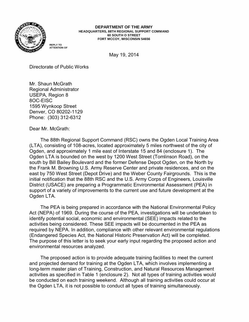
DEPARTMENT OF THE ARMY HEADQUARTERS, 88TH REGIONAL SUPPORT COMMAND 60 SOUTH O STREET FORT MCCOY, WISCONSIN 54656 REPLY TO ATTENTION OF May 19, 2014 Directorate of Public Works Mr. Shaun McGrath Regional Administrator USEPA, Region 8 8OC-EISC 1595 Wynkoop Street Denver, CO 80202-1129 Phone: (303) 312-6312 Dear Mr. McGrath: The 88th Regional Support Command (RSC) owns the Ogden Local Training Area (LTA), consisting of 108-acres, located approximately 5 miles northwest of the city of Ogden, and approximately 1 mile east of Interstate 15 and 84 (enclosure 1). The Ogden LTA is bounded on the west by 1200 West Street (Tomlinson Road), on the south by Bill Bailey Boulevard and the former Defense Depot Ogden, on the North by the Frank M. Browning U.S. Army Reserve Center and private residences, and on the east by 750 West Street (Depot Drive) and the Weber County Fairgrounds. This is the initial notification that the 88th RSC and the U.S. Army Corps of Engineers, Louisville District (USACE) are preparing a Programmatic Environmental Assessment (PEA) in support of a variety of improvements to the current use and future development at the Ogden LTA. The PEA is being prepared in accordance with the National Environmental Policy Act (NEPA) of 1969. During the course of the PEA, investigations will be undertaken to identify potential social, economic and environmental (SEE) impacts related to the activities being considered. These SEE impacts will be documented in the PEA as required by NEPA. In addition, compliance with other relevant environmental regulations (Endangered Species Act, the National Historic Preservation Act) will be completed. The purpose of this letter is to seek your early input regarding the proposed action and environmental resources analyzed. The proposed action is to provide adequate training facilities to meet the current and projected demand for training at the Ogden LTA, which involves implementing a long-term master plan of Training, Construction, and Natural Resources Management activities as specified in Table 1 (enclosure 2). Not all types of training activities would be conducted on each training weekend. Although all training activities could occur at the Ogden LTA, it is not possible to conduct all types of training simultaneously.
-
Upload
hoangtuyen -
Category
Documents
-
view
228 -
download
4
Transcript of DEPARTMENT OF THE ARMY HEADQUARTERS, … of the army headquarters, ... improvised explosive device...
DEPARTMENT OF THE ARMY
HEADQUARTERS, 88TH REGIONAL SUPPORT COMMAND 60 SOUTH O STREET
FORT MCCOY, WISCONSIN 54656 REPLY TO ATTENTION OF
May 19, 2014
Directorate of Public Works Mr. Shaun McGrath Regional Administrator USEPA, Region 8 8OC-EISC 1595 Wynkoop Street Denver, CO 80202-1129 Phone: (303) 312-6312 Dear Mr. McGrath:
The 88th Regional Support Command (RSC) owns the Ogden Local Training Area (LTA), consisting of 108-acres, located approximately 5 miles northwest of the city of Ogden, and approximately 1 mile east of Interstate 15 and 84 (enclosure 1). The Ogden LTA is bounded on the west by 1200 West Street (Tomlinson Road), on the south by Bill Bailey Boulevard and the former Defense Depot Ogden, on the North by the Frank M. Browning U.S. Army Reserve Center and private residences, and on the east by 750 West Street (Depot Drive) and the Weber County Fairgrounds. This is the initial notification that the 88th RSC and the U.S. Army Corps of Engineers, Louisville District (USACE) are preparing a Programmatic Environmental Assessment (PEA) in support of a variety of improvements to the current use and future development at the Ogden LTA.
The PEA is being prepared in accordance with the National Environmental Policy
Act (NEPA) of 1969. During the course of the PEA, investigations will be undertaken to identify potential social, economic and environmental (SEE) impacts related to the activities being considered. These SEE impacts will be documented in the PEA as required by NEPA. In addition, compliance with other relevant environmental regulations (Endangered Species Act, the National Historic Preservation Act) will be completed. The purpose of this letter is to seek your early input regarding the proposed action and environmental resources analyzed.
The proposed action is to provide adequate training facilities to meet the current
and projected demand for training at the Ogden LTA, which involves implementing a long-term master plan of Training, Construction, and Natural Resources Management activities as specified in Table 1 (enclosure 2). Not all types of training activities would be conducted on each training weekend. Although all training activities could occur at the Ogden LTA, it is not possible to conduct all types of training simultaneously.
As part of the NEPA early coordination process, we are identifying key issues that will need to be addressed in the PEA. At this time, we are requesting that you provide us with any comments relative to specific issues or geographic areas of concern based on your expertise or regulatory jurisdiction; available technical information regarding these issues; and, mitigation or permitting requirements that may be necessary for project implementation.
We are requesting your written comments within 30 days from receipt of this
letter. Comments received at this time will not be directly responded to but will be used to prepare the PEA. Comments should be submitted to: Lisa Gulbranson, 88th RSC-DPW, 506 Roeder Circle, Fort Snelling, MN 55111-4009, or via electronic mail at [email protected]. If you would like to be notified when the PEA will be available for public review, please contact Ms. Gulbranson at (612) 713-3752 or via electronic mail. We look forward to working cooperatively with you towards a successful outcome for all. Sincerely, David L. Moore Chief, Public Works- Environmental Division Enclosures


2.0 DESCRIPTION OF THE PROPOSED ACTION AND ALTERNATIVES
FINAL DOPAA: OGDEN LTA USACE SEPTEMBER 2013 LOUISVILLE DISTRICT
4
FIGURE 1. General Site Location of the Ogden Local Training Area, Ogden, Weber County, Utah
Not to scale

2.0 DESCRIPTION OF THE PROPOSED ACTION AND ALTERNATIVES
FINAL DOPAA: OGDEN LTA USACE SEPTEMBER 2013 LOUISVILLE DISTRICT
5
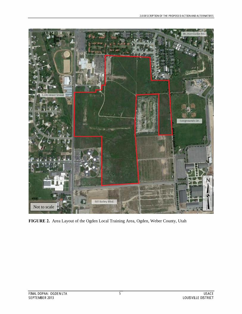
FIGURE 2. Area Layout of the Ogden Local Training Area, Ogden, Weber County, Utah
Not to scale
h2edecls
Text Box
1200 West Street
h2edecls
Line
h2edecls
Text Box
W. Harrisville Rd.
h2edecls
Line
h2edecls
Text Box
Bill Bailey Blvd.
h2edecls
Line
h2edecls
Text Box
Fairgrounds Dr.
h2edecls
Line
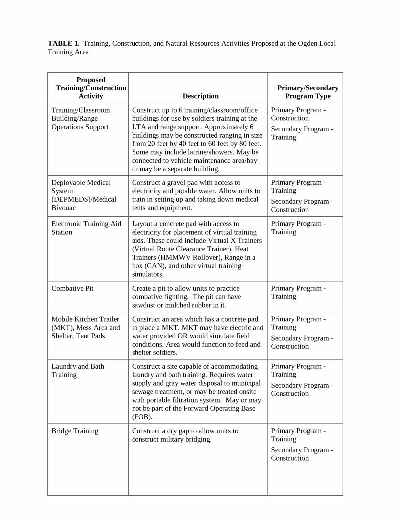
TABLE 1. Training, Construction, and Natural Resources Activities Proposed at the Ogden Local Training Area
Proposed
Training/Construction Activity Description
Primary/Secondary Program Type
Training/Classroom Building/Range Operations Support
Construct up to 6 training/classroom/office buildings for use by soldiers training at the LTA and range support. Approximately 6 buildings may be constructed ranging in size from 20 feet by 40 feet to 60 feet by 80 feet. Some may include latrine/showers. May be connected to vehicle maintenance area/bay or may be a separate building.
Primary Program - Construction Secondary Program - Training
Deployable Medical System (DEPMEDS)/Medical Bivouac
Construct a gravel pad with access to electricity and potable water. Allow units to train in setting up and taking down medical tents and equipment.
Primary Program - Training Secondary Program - Construction
Electronic Training Aid Station
Layout a concrete pad with access to electricity for placement of virtual training aids. These could include Virtual X Trainers (Virtual Route Clearance Trainer), Heat Trainers (HMMWV Rollover), Range in a box (CAN), and other virtual training simulators.
Primary Program - Training
Combative Pit Create a pit to allow units to practice combative fighting. The pit can have sawdust or mulched rubber in it.
Primary Program - Training
Mobile Kitchen Trailer (MKT), Mess Area and Shelter, Tent Pads.
Construct an area which has a concrete pad to place a MKT. MKT may have electric and water provided OR would simulate field conditions. Area would function to feed and shelter soldiers.
Primary Program - Training Secondary Program - Construction
Laundry and Bath Training
Construct a site capable of accommodating laundry and bath training. Requires water supply and gray water disposal to municipal sewage treatment, or may be treated onsite with portable filtration system. May or may not be part of the Forward Operating Base (FOB).
Primary Program - Training Secondary Program - Construction
Bridge Training Construct a dry gap to allow units to construct military bridging.
Primary Program - Training Secondary Program - Construction
2
Proposed Training/Construction
Activity Description Primary/Secondary
Program Type
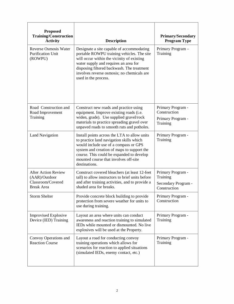
Reverse Osmosis Water Purification Unit (ROWPU)
Designate a site capable of accommodating portable ROWPU training vehicles. The site will occur within the vicinity of existing water supply and requires an area for disposing filtered backwash. The treatment involves reverse osmosis; no chemicals are used in the process.
Primary Program – Training
Road Construction and Road Improvement Training
Construct new roads and practice using equipment. Improve existing roads (i.e. widen, grade). Use supplied gravel/rock materials to practice spreading gravel over unpaved roads to smooth ruts and potholes.
Primary Program - Construction Primary Program - Training
Land Navigation Install points across the LTA to allow units to practice land navigation skills which would include use of a compass or GPS system and creation of maps to support the course. This could be expanded to develop mounted course that involves off-site destinations.
Primary Program - Training
After Action Review (AAR)/Outdoor Classroom/Covered Break Area
Construct covered bleachers (at least 12-feet tall) to allow instructors to brief units before and after training activities, and to provide a shaded area for breaks.
Primary Program - Training Secondary Program - Construction
Storm Shelter Provide concrete block building to provide protection from severe weather for units to use during training.
Primary Program - Construction
Improvised Explosive Device (IED) Training
Layout an area where units can conduct awareness and reaction training to simulated IEDs while mounted or dismounted. No live explosives will be used at the Property.
Primary Program - Training
Convoy Operations and Reaction Course
Layout a road for conducting convoy training operations which allows for scenarios for reaction to applied situations (simulated IEDs, enemy contact, etc.)
Primary Program - Training
3
Proposed Training/Construction
Activity Description Primary/Secondary
Program Type
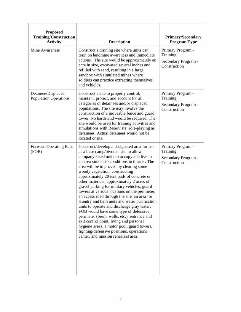
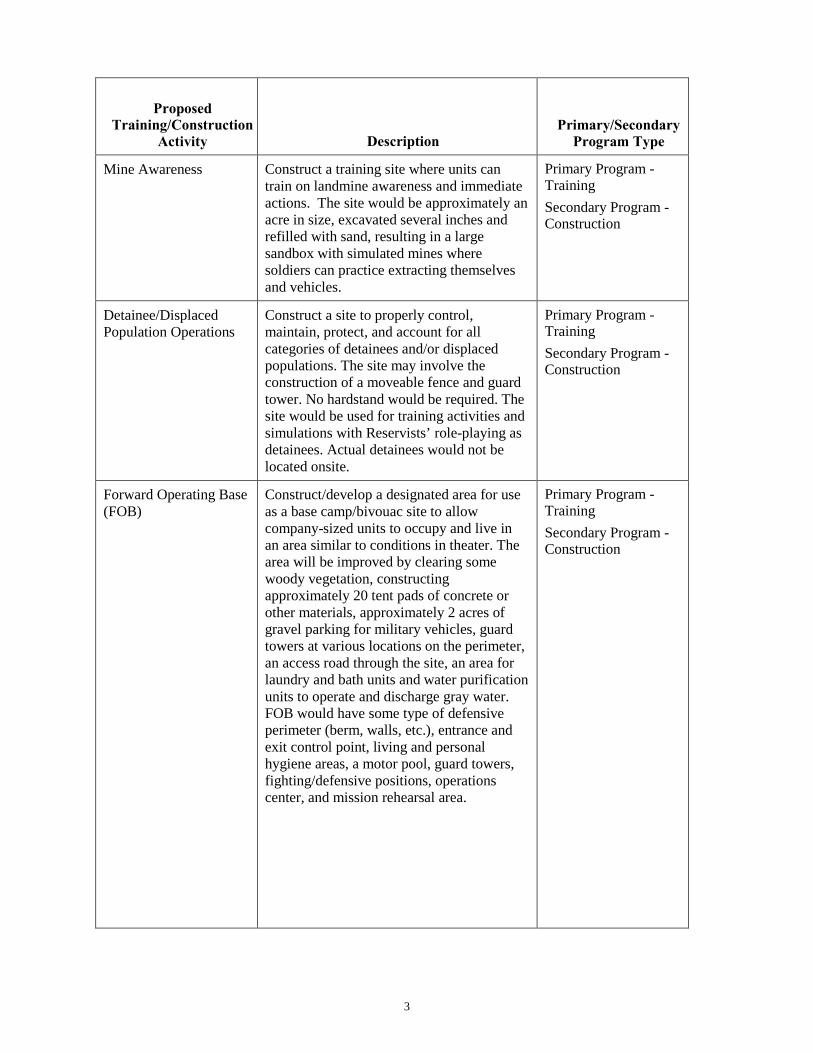
Mine Awareness Construct a training site where units can train on landmine awareness and immediate actions. The site would be approximately an acre in size, excavated several inches and refilled with sand, resulting in a large sandbox with simulated mines where soldiers can practice extracting themselves and vehicles.
Primary Program - Training Secondary Program - Construction
Detainee/Displaced Population Operations
Construct a site to properly control, maintain, protect, and account for all categories of detainees and/or displaced populations. The site may involve the construction of a moveable fence and guard tower. No hardstand would be required. The site would be used for training activities and simulations with Reservists’ role-playing as detainees. Actual detainees would not be located onsite.
Primary Program - Training Secondary Program - Construction
Forward Operating Base (FOB)
Construct/develop a designated area for use as a base camp/bivouac site to allow company-sized units to occupy and live in an area similar to conditions in theater. The area will be improved by clearing some woody vegetation, constructing approximately 20 tent pads of concrete or other materials, approximately 2 acres of gravel parking for military vehicles, guard towers at various locations on the perimeter, an access road through the site, an area for laundry and bath units and water purification units to operate and discharge gray water. FOB would have some type of defensive perimeter (berm, walls, etc.), entrance and exit control point, living and personal hygiene areas, a motor pool, guard towers, fighting/defensive positions, operations center, and mission rehearsal area.
Primary Program - Training Secondary Program - Construction
4
Proposed Training/Construction
Activity Description Primary/Secondary
Program Type
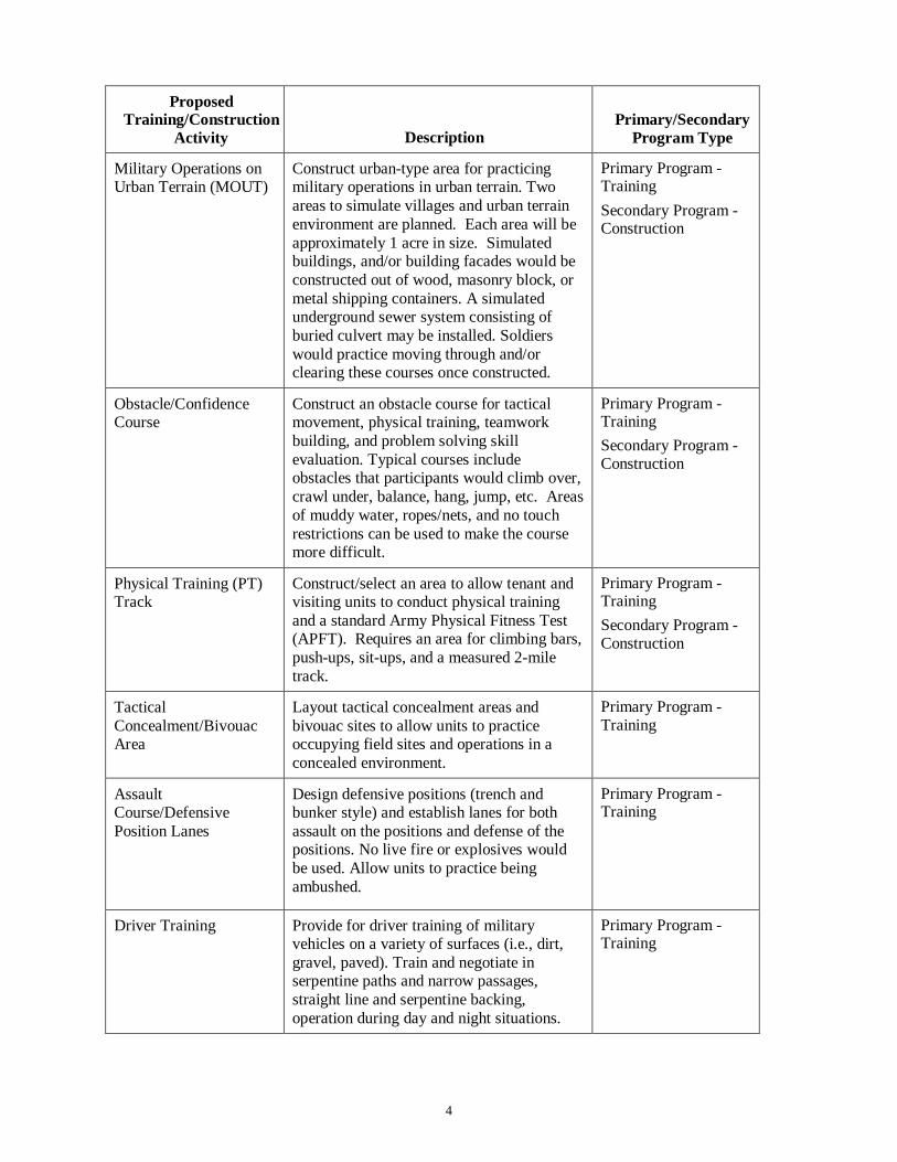
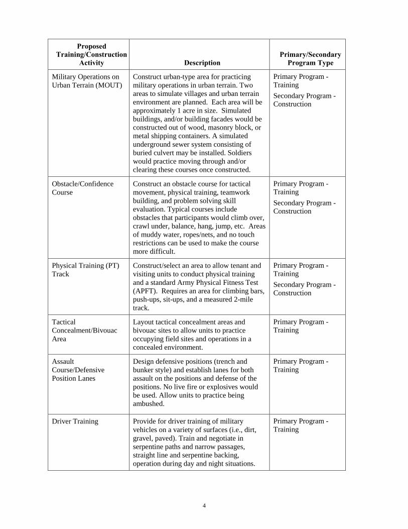
Military Operations on Urban Terrain (MOUT)
Construct urban-type area for practicing military operations in urban terrain. Two areas to simulate villages and urban terrain environment are planned. Each area will be approximately 1 acre in size. Simulated buildings, and/or building facades would be constructed out of wood, masonry block, or metal shipping containers. A simulated underground sewer system consisting of buried culvert may be installed. Soldiers would practice moving through and/or clearing these courses once constructed.
Primary Program - Training Secondary Program - Construction
Obstacle/Confidence Course
Construct an obstacle course for tactical movement, physical training, teamwork building, and problem solving skill evaluation. Typical courses include obstacles that participants would climb over, crawl under, balance, hang, jump, etc. Areas of muddy water, ropes/nets, and no touch restrictions can be used to make the course more difficult.
Primary Program - Training Secondary Program - Construction
Physical Training (PT) Track
Construct/select an area to allow tenant and visiting units to conduct physical training and a standard Army Physical Fitness Test (APFT). Requires an area for climbing bars, push-ups, sit-ups, and a measured 2-mile track.
Primary Program - Training Secondary Program - Construction
Tactical Concealment/Bivouac Area
Layout tactical concealment areas and bivouac sites to allow units to practice occupying field sites and operations in a concealed environment.
Primary Program - Training
Assault Course/Defensive Position Lanes
Design defensive positions (trench and bunker style) and establish lanes for both assault on the positions and defense of the positions. No live fire or explosives would be used. Allow units to practice being ambushed.
Primary Program - Training
Driver Training Provide for driver training of military vehicles on a variety of surfaces (i.e., dirt, gravel, paved). Train and negotiate in serpentine paths and narrow passages, straight line and serpentine backing, operation during day and night situations.
Primary Program - Training
5
Proposed Training/Construction
Activity Description Primary/Secondary
Program Type
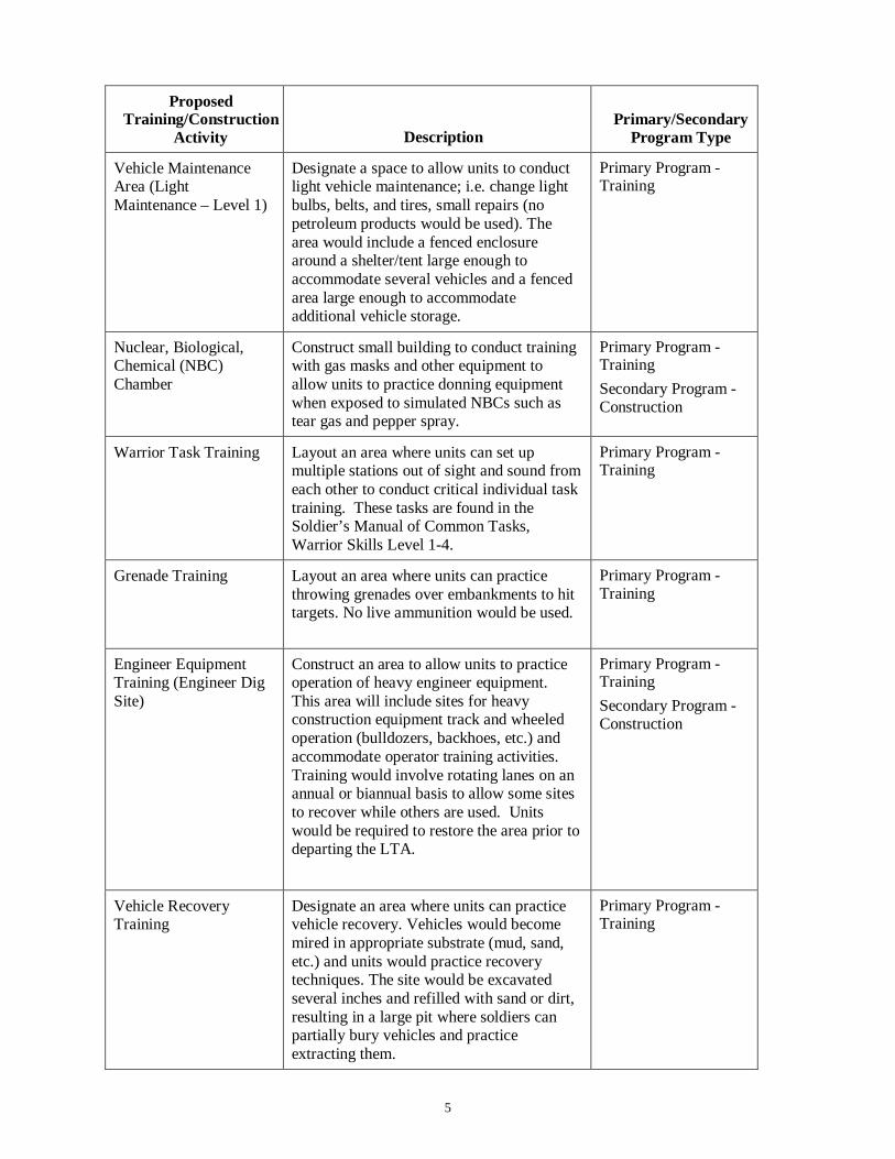
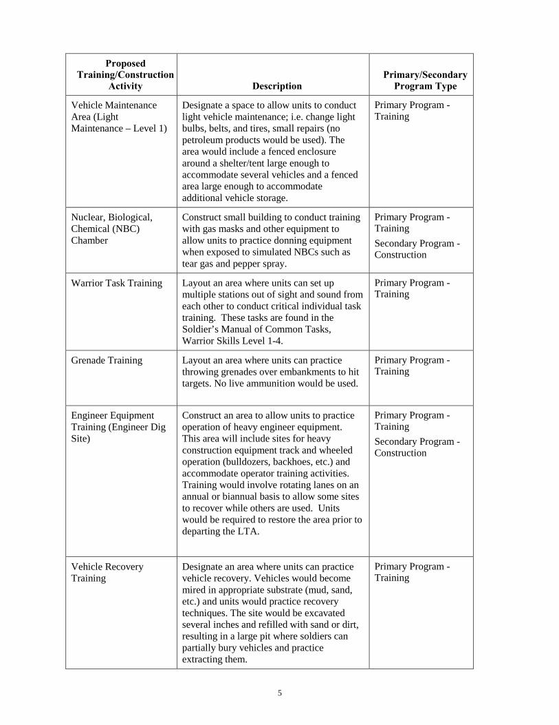
Vehicle Maintenance Area (Light Maintenance – Level 1)
Designate a space to allow units to conduct light vehicle maintenance; i.e. change light bulbs, belts, and tires, small repairs (no petroleum products would be used). The area would include a fenced enclosure around a shelter/tent large enough to accommodate several vehicles and a fenced area large enough to accommodate additional vehicle storage.
Primary Program - Training
Nuclear, Biological, Chemical (NBC) Chamber
Construct small building to conduct training with gas masks and other equipment to allow units to practice donning equipment when exposed to simulated NBCs such as tear gas and pepper spray.
Primary Program - Training Secondary Program - Construction
Warrior Task Training Layout an area where units can set up multiple stations out of sight and sound from each other to conduct critical individual task training. These tasks are found in the Soldier’s Manual of Common Tasks, Warrior Skills Level 1-4.
Primary Program - Training
Grenade Training Layout an area where units can practice throwing grenades over embankments to hit targets. No live ammunition would be used.
Primary Program - Training
Engineer Equipment Training (Engineer Dig Site)
Construct an area to allow units to practice operation of heavy engineer equipment. This area will include sites for heavy construction equipment track and wheeled operation (bulldozers, backhoes, etc.) and accommodate operator training activities. Training would involve rotating lanes on an annual or biannual basis to allow some sites to recover while others are used. Units would be required to restore the area prior to departing the LTA.
Primary Program - Training Secondary Program - Construction
Vehicle Recovery Training
Designate an area where units can practice vehicle recovery. Vehicles would become mired in appropriate substrate (mud, sand, etc.) and units would practice recovery techniques. The site would be excavated several inches and refilled with sand or dirt, resulting in a large pit where soldiers can partially bury vehicles and practice extracting them.
Primary Program - Training
6
Proposed Training/Construction
Activity Description Primary/Secondary
Program Type
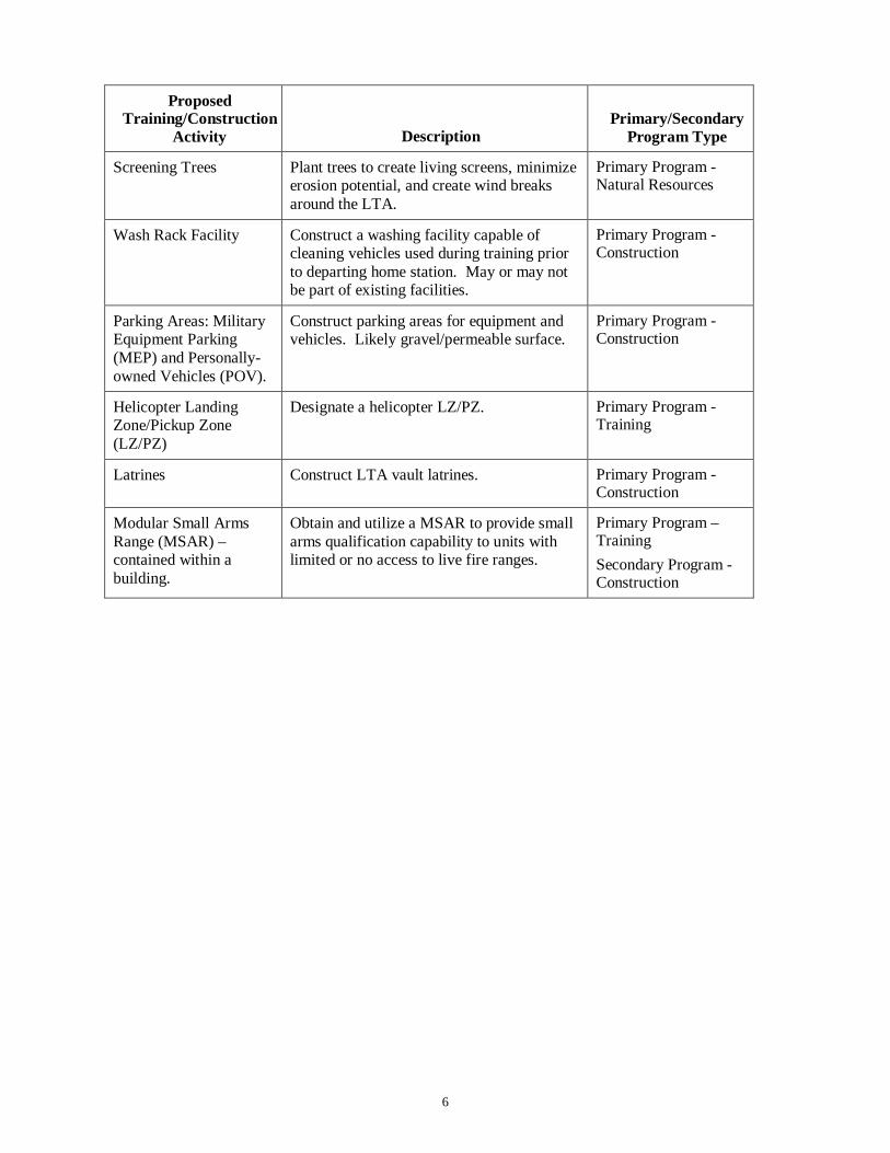
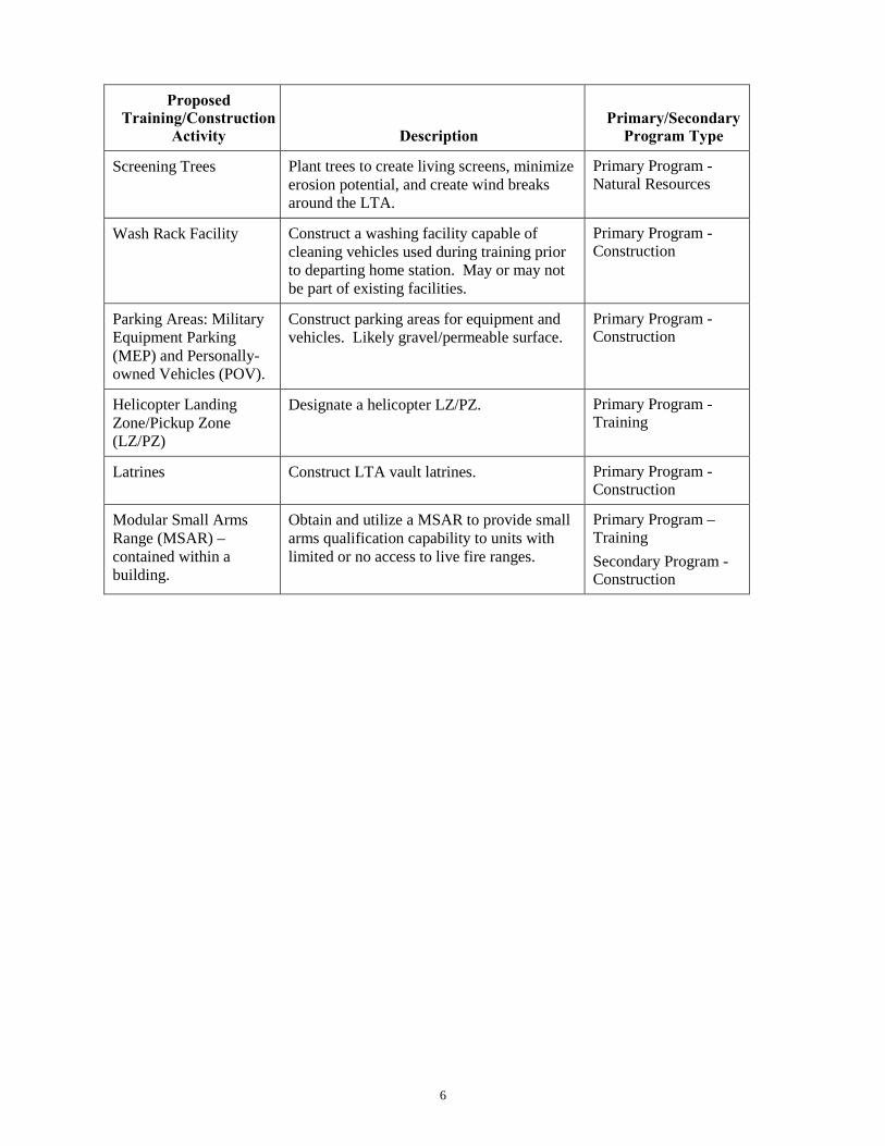
Screening Trees Plant trees to create living screens, minimize erosion potential, and create wind breaks around the LTA.
Primary Program - Natural Resources
Wash Rack Facility Construct a washing facility capable of cleaning vehicles used during training prior to departing home station. May or may not be part of existing facilities.
Primary Program - Construction
Parking Areas: Military Equipment Parking (MEP) and Personally-owned Vehicles (POV).
Construct parking areas for equipment and vehicles. Likely gravel/permeable surface.
Primary Program - Construction
Helicopter Landing Zone/Pickup Zone (LZ/PZ)
Designate a helicopter LZ/PZ. Primary Program - Training
Latrines Construct LTA vault latrines. Primary Program - Construction
Modular Small Arms Range (MSAR) – contained within a building.
Obtain and utilize a MSAR to provide small arms qualification capability to units with limited or no access to live fire ranges.
Primary Program – Training Secondary Program - Construction
DEPARTMENT OF THE ARMY
HEADQUARTERS, 88TH REGIONAL SUPPORT COMMAND 60 SOUTH O STREET
FORT MCCOY, WISCONSIN 54656 REPLY TO ATTENTION OF
May 19, 2014
Directorate of Public Works Mr. Bryce Bird Air Quality Director P.O. Box 144820 Salt Lake City, Utah 84114-482 Phone: (801) 536-4064 Dear Mr. Bird:
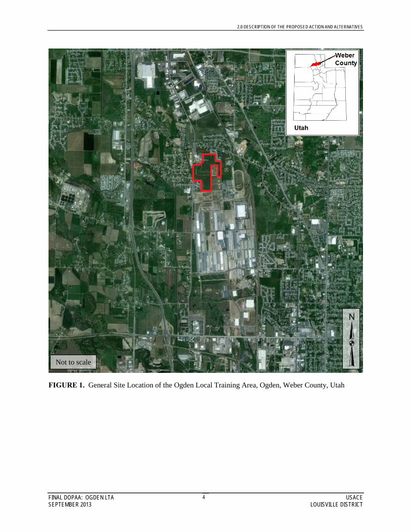
The 88th Regional Support Command (RSC) owns the Ogden Local Training Area (LTA), consisting of 108-acres, located approximately 5 miles northwest of the city of Ogden, and approximately 1 mile east of Interstate 15 and 84 (enclosure 1). The Ogden LTA is bounded on the west by 1200 West Street (Tomlinson Road), on the south by Bill Bailey Boulevard and the former Defense Depot Ogden, on the North by the Frank M. Browning U.S. Army Reserve Center and private residences, and on the east by 750 West Street (Depot Drive) and the Weber County Fairgrounds. This is the initial notification that the 88th RSC and the U.S. Army Corps of Engineers, Louisville District (USACE) are preparing a Programmatic Environmental Assessment (PEA) in support of a variety of improvements to the current use and future development at the Ogden LTA.
The PEA is being prepared in accordance with the National Environmental Policy
Act (NEPA) of 1969. During the course of the PEA, investigations will be undertaken to identify potential social, economic and environmental (SEE) impacts related to the activities being considered. These SEE impacts will be documented in the PEA as required by NEPA. In addition, compliance with other relevant environmental regulations (Endangered Species Act, the National Historic Preservation Act) will be completed. The purpose of this letter is to seek your early input regarding the proposed action and environmental resources analyzed.
The proposed action is to provide adequate training facilities to meet the current
and projected demand for training at the Ogden LTA, which involves implementing a long-term master plan of Training, Construction, and Natural Resources Management activities as specified in Table 1 (enclosure 2). Not all types of training activities would be conducted on each training weekend. Although all training activities could occur at the Ogden LTA, it is not possible to conduct all types of training simultaneously.

2.0 DESCRIPTION OF THE PROPOSED ACTION AND ALTERNATIVES
FINAL DOPAA: OGDEN LTA USACE SEPTEMBER 2013 LOUISVILLE DISTRICT
4
FIGURE 1. General Site Location of the Ogden Local Training Area, Ogden, Weber County, Utah
Not to scale

2.0 DESCRIPTION OF THE PROPOSED ACTION AND ALTERNATIVES
FINAL DOPAA: OGDEN LTA USACE SEPTEMBER 2013 LOUISVILLE DISTRICT
5
FIGURE 2. Area Layout of the Ogden Local Training Area, Ogden, Weber County, Utah
Not to scale
h2edecls
Text Box
1200 West Street
h2edecls
Line
h2edecls
Text Box
W. Harrisville Rd.
h2edecls
Line
h2edecls
Text Box
Bill Bailey Blvd.
h2edecls
Line
h2edecls
Text Box
Fairgrounds Dr.
h2edecls
Line

TABLE 1. Training, Construction, and Natural Resources Activities Proposed at the Ogden Local Training Area
Proposed
Training/Construction Activity Description
Primary/Secondary Program Type
Training/Classroom Building/Range Operations Support
Construct up to 6 training/classroom/office buildings for use by soldiers training at the LTA and range support. Approximately 6 buildings may be constructed ranging in size from 20 feet by 40 feet to 60 feet by 80 feet. Some may include latrine/showers. May be connected to vehicle maintenance area/bay or may be a separate building.
Primary Program - Construction Secondary Program - Training
Deployable Medical System (DEPMEDS)/Medical Bivouac
Construct a gravel pad with access to electricity and potable water. Allow units to train in setting up and taking down medical tents and equipment.
Primary Program - Training Secondary Program - Construction
Electronic Training Aid Station
Layout a concrete pad with access to electricity for placement of virtual training aids. These could include Virtual X Trainers (Virtual Route Clearance Trainer), Heat Trainers (HMMWV Rollover), Range in a box (CAN), and other virtual training simulators.
Primary Program - Training
Combative Pit Create a pit to allow units to practice combative fighting. The pit can have sawdust or mulched rubber in it.
Primary Program - Training
Mobile Kitchen Trailer (MKT), Mess Area and Shelter, Tent Pads.
Construct an area which has a concrete pad to place a MKT. MKT may have electric and water provided OR would simulate field conditions. Area would function to feed and shelter soldiers.
Primary Program - Training Secondary Program - Construction
Laundry and Bath Training
Construct a site capable of accommodating laundry and bath training. Requires water supply and gray water disposal to municipal sewage treatment, or may be treated onsite with portable filtration system. May or may not be part of the Forward Operating Base (FOB).
Primary Program - Training Secondary Program - Construction
Bridge Training Construct a dry gap to allow units to construct military bridging.
Primary Program - Training Secondary Program - Construction

2
Proposed Training/Construction
Activity Description Primary/Secondary
Program Type
Reverse Osmosis Water Purification Unit (ROWPU)
Designate a site capable of accommodating portable ROWPU training vehicles. The site will occur within the vicinity of existing water supply and requires an area for disposing filtered backwash. The treatment involves reverse osmosis; no chemicals are used in the process.
Primary Program – Training
Road Construction and Road Improvement Training
Construct new roads and practice using equipment. Improve existing roads (i.e. widen, grade). Use supplied gravel/rock materials to practice spreading gravel over unpaved roads to smooth ruts and potholes.
Primary Program - Construction Primary Program - Training
Land Navigation Install points across the LTA to allow units to practice land navigation skills which would include use of a compass or GPS system and creation of maps to support the course. This could be expanded to develop mounted course that involves off-site destinations.
Primary Program - Training
After Action Review (AAR)/Outdoor Classroom/Covered Break Area
Construct covered bleachers (at least 12-feet tall) to allow instructors to brief units before and after training activities, and to provide a shaded area for breaks.
Primary Program - Training Secondary Program - Construction
Storm Shelter Provide concrete block building to provide protection from severe weather for units to use during training.
Primary Program - Construction
Improvised Explosive Device (IED) Training
Layout an area where units can conduct awareness and reaction training to simulated IEDs while mounted or dismounted. No live explosives will be used at the Property.
Primary Program - Training
Convoy Operations and Reaction Course
Layout a road for conducting convoy training operations which allows for scenarios for reaction to applied situations (simulated IEDs, enemy contact, etc.)
Primary Program - Training

3
Proposed Training/Construction
Activity Description Primary/Secondary
Program Type
Mine Awareness Construct a training site where units can train on landmine awareness and immediate actions. The site would be approximately an acre in size, excavated several inches and refilled with sand, resulting in a large sandbox with simulated mines where soldiers can practice extracting themselves and vehicles.
Primary Program - Training Secondary Program - Construction
Detainee/Displaced Population Operations
Construct a site to properly control, maintain, protect, and account for all categories of detainees and/or displaced populations. The site may involve the construction of a moveable fence and guard tower. No hardstand would be required. The site would be used for training activities and simulations with Reservists’ role-playing as detainees. Actual detainees would not be located onsite.
Primary Program - Training Secondary Program - Construction
Forward Operating Base (FOB)
Construct/develop a designated area for use as a base camp/bivouac site to allow company-sized units to occupy and live in an area similar to conditions in theater. The area will be improved by clearing some woody vegetation, constructing approximately 20 tent pads of concrete or other materials, approximately 2 acres of gravel parking for military vehicles, guard towers at various locations on the perimeter, an access road through the site, an area for laundry and bath units and water purification units to operate and discharge gray water. FOB would have some type of defensive perimeter (berm, walls, etc.), entrance and exit control point, living and personal hygiene areas, a motor pool, guard towers, fighting/defensive positions, operations center, and mission rehearsal area.
Primary Program - Training Secondary Program - Construction
4
Proposed Training/Construction
Activity Description Primary/Secondary
Program Type
Military Operations on Urban Terrain (MOUT)
Construct urban-type area for practicing military operations in urban terrain. Two areas to simulate villages and urban terrain environment are planned. Each area will be approximately 1 acre in size. Simulated buildings, and/or building facades would be constructed out of wood, masonry block, or metal shipping containers. A simulated underground sewer system consisting of buried culvert may be installed. Soldiers would practice moving through and/or clearing these courses once constructed.
Primary Program - Training Secondary Program - Construction
Obstacle/Confidence Course
Construct an obstacle course for tactical movement, physical training, teamwork building, and problem solving skill evaluation. Typical courses include obstacles that participants would climb over, crawl under, balance, hang, jump, etc. Areas of muddy water, ropes/nets, and no touch restrictions can be used to make the course more difficult.
Primary Program - Training Secondary Program - Construction
Physical Training (PT) Track
Construct/select an area to allow tenant and visiting units to conduct physical training and a standard Army Physical Fitness Test (APFT). Requires an area for climbing bars, push-ups, sit-ups, and a measured 2-mile track.
Primary Program - Training Secondary Program - Construction
Tactical Concealment/Bivouac Area
Layout tactical concealment areas and bivouac sites to allow units to practice occupying field sites and operations in a concealed environment.
Primary Program - Training
Assault Course/Defensive Position Lanes
Design defensive positions (trench and bunker style) and establish lanes for both assault on the positions and defense of the positions. No live fire or explosives would be used. Allow units to practice being ambushed.
Primary Program - Training
Driver Training Provide for driver training of military vehicles on a variety of surfaces (i.e., dirt, gravel, paved). Train and negotiate in serpentine paths and narrow passages, straight line and serpentine backing, operation during day and night situations.
Primary Program - Training

5
Proposed Training/Construction
Activity Description Primary/Secondary
Program Type
Vehicle Maintenance Area (Light Maintenance – Level 1)
Designate a space to allow units to conduct light vehicle maintenance; i.e. change light bulbs, belts, and tires, small repairs (no petroleum products would be used). The area would include a fenced enclosure around a shelter/tent large enough to accommodate several vehicles and a fenced area large enough to accommodate additional vehicle storage.
Primary Program - Training
Nuclear, Biological, Chemical (NBC) Chamber
Construct small building to conduct training with gas masks and other equipment to allow units to practice donning equipment when exposed to simulated NBCs such as tear gas and pepper spray.
Primary Program - Training Secondary Program - Construction
Warrior Task Training Layout an area where units can set up multiple stations out of sight and sound from each other to conduct critical individual task training. These tasks are found in the Soldier’s Manual of Common Tasks, Warrior Skills Level 1-4.
Primary Program - Training
Grenade Training Layout an area where units can practice throwing grenades over embankments to hit targets. No live ammunition would be used.
Primary Program - Training
Engineer Equipment Training (Engineer Dig Site)
Construct an area to allow units to practice operation of heavy engineer equipment. This area will include sites for heavy construction equipment track and wheeled operation (bulldozers, backhoes, etc.) and accommodate operator training activities. Training would involve rotating lanes on an annual or biannual basis to allow some sites to recover while others are used. Units would be required to restore the area prior to departing the LTA.
Primary Program - Training Secondary Program - Construction
Vehicle Recovery Training
Designate an area where units can practice vehicle recovery. Vehicles would become mired in appropriate substrate (mud, sand, etc.) and units would practice recovery techniques. The site would be excavated several inches and refilled with sand or dirt, resulting in a large pit where soldiers can partially bury vehicles and practice extracting them.
Primary Program - Training

6
Proposed Training/Construction
Activity Description Primary/Secondary
Program Type
Screening Trees Plant trees to create living screens, minimize erosion potential, and create wind breaks around the LTA.
Primary Program - Natural Resources
Wash Rack Facility Construct a washing facility capable of cleaning vehicles used during training prior to departing home station. May or may not be part of existing facilities.
Primary Program - Construction
Parking Areas: Military Equipment Parking (MEP) and Personally-owned Vehicles (POV).
Construct parking areas for equipment and vehicles. Likely gravel/permeable surface.
Primary Program - Construction
Helicopter Landing Zone/Pickup Zone (LZ/PZ)
Designate a helicopter LZ/PZ. Primary Program - Training
Latrines Construct LTA vault latrines. Primary Program - Construction
Modular Small Arms Range (MSAR) – contained within a building.
Obtain and utilize a MSAR to provide small arms qualification capability to units with limited or no access to live fire ranges.
Primary Program – Training Secondary Program - Construction
DEPARTMENT OF THE ARMY
HEADQUARTERS, 88TH REGIONAL SUPPORT COMMAND 60 SOUTH O STREET
FORT MCCOY, WISCONSIN 54656 REPLY TO ATTENTION OF
May 19, 2014
Directorate of Public Works Ms. Jan Zogmaister Weber County Commission 2380 Washington Blvd, Suite 360 Ogden, UT 84401 Phone: (801) 399-8406 Dear Ms. Zogmaister:
The 88th Regional Support Command (RSC) owns the Ogden Local Training Area (LTA), consisting of 108-acres, located approximately 5 miles northwest of the city of Ogden, and approximately 1 mile east of Interstate 15 and 84 (enclosure 1). The Ogden LTA is bounded on the west by 1200 West Street (Tomlinson Road), on the south by Bill Bailey Boulevard and the former Defense Depot Ogden, on the North by the Frank M. Browning U.S. Army Reserve Center and private residences, and on the east by 750 West Street (Depot Drive) and the Weber County Fairgrounds. This is the initial notification that the 88th RSC and the U.S. Army Corps of Engineers, Louisville District (USACE) are preparing a Programmatic Environmental Assessment (PEA) in support of a variety of improvements to the current use and future development at the Ogden LTA.
The PEA is being prepared in accordance with the National Environmental Policy
Act (NEPA) of 1969. During the course of the PEA, investigations will be undertaken to identify potential social, economic and environmental (SEE) impacts related to the activities being considered. These SEE impacts will be documented in the PEA as required by NEPA. In addition, compliance with other relevant environmental regulations (Endangered Species Act, the National Historic Preservation Act) will be completed. The purpose of this letter is to seek your early input regarding the proposed action and environmental resources analyzed.
The proposed action is to provide adequate training facilities to meet the current
and projected demand for training at the Ogden LTA, which involves implementing a long-term master plan of Training, Construction, and Natural Resources Management activities as specified in Table 1 (enclosure 2). Not all types of training activities would be conducted on each training weekend. Although all training activities could occur at the Ogden LTA, it is not possible to conduct all types of training simultaneously.


2.0 DESCRIPTION OF THE PROPOSED ACTION AND ALTERNATIVES
FINAL DOPAA: OGDEN LTA USACE SEPTEMBER 2013 LOUISVILLE DISTRICT
4
FIGURE 1. General Site Location of the Ogden Local Training Area, Ogden, Weber County, Utah
Not to scale

2.0 DESCRIPTION OF THE PROPOSED ACTION AND ALTERNATIVES
FINAL DOPAA: OGDEN LTA USACE SEPTEMBER 2013 LOUISVILLE DISTRICT
5
FIGURE 2. Area Layout of the Ogden Local Training Area, Ogden, Weber County, Utah
Not to scale
h2edecls
Text Box
1200 West Street
h2edecls
Line
h2edecls
Text Box
W. Harrisville Rd.
h2edecls
Line
h2edecls
Text Box
Bill Bailey Blvd.
h2edecls
Line
h2edecls
Text Box
Fairgrounds Dr.
h2edecls
Line

TABLE 1. Training, Construction, and Natural Resources Activities Proposed at the Ogden Local Training Area
Proposed
Training/Construction Activity Description
Primary/Secondary Program Type
Training/Classroom Building/Range Operations Support
Construct up to 6 training/classroom/office buildings for use by soldiers training at the LTA and range support. Approximately 6 buildings may be constructed ranging in size from 20 feet by 40 feet to 60 feet by 80 feet. Some may include latrine/showers. May be connected to vehicle maintenance area/bay or may be a separate building.
Primary Program - Construction Secondary Program - Training
Deployable Medical System (DEPMEDS)/Medical Bivouac
Construct a gravel pad with access to electricity and potable water. Allow units to train in setting up and taking down medical tents and equipment.
Primary Program - Training Secondary Program - Construction
Electronic Training Aid Station
Layout a concrete pad with access to electricity for placement of virtual training aids. These could include Virtual X Trainers (Virtual Route Clearance Trainer), Heat Trainers (HMMWV Rollover), Range in a box (CAN), and other virtual training simulators.
Primary Program - Training
Combative Pit Create a pit to allow units to practice combative fighting. The pit can have sawdust or mulched rubber in it.
Primary Program - Training
Mobile Kitchen Trailer (MKT), Mess Area and Shelter, Tent Pads.
Construct an area which has a concrete pad to place a MKT. MKT may have electric and water provided OR would simulate field conditions. Area would function to feed and shelter soldiers.
Primary Program - Training Secondary Program - Construction
Laundry and Bath Training
Construct a site capable of accommodating laundry and bath training. Requires water supply and gray water disposal to municipal sewage treatment, or may be treated onsite with portable filtration system. May or may not be part of the Forward Operating Base (FOB).
Primary Program - Training Secondary Program - Construction
Bridge Training Construct a dry gap to allow units to construct military bridging.
Primary Program - Training Secondary Program - Construction

2
Proposed Training/Construction
Activity Description Primary/Secondary
Program Type
Reverse Osmosis Water Purification Unit (ROWPU)
Designate a site capable of accommodating portable ROWPU training vehicles. The site will occur within the vicinity of existing water supply and requires an area for disposing filtered backwash. The treatment involves reverse osmosis; no chemicals are used in the process.
Primary Program – Training
Road Construction and Road Improvement Training
Construct new roads and practice using equipment. Improve existing roads (i.e. widen, grade). Use supplied gravel/rock materials to practice spreading gravel over unpaved roads to smooth ruts and potholes.
Primary Program - Construction Primary Program - Training
Land Navigation Install points across the LTA to allow units to practice land navigation skills which would include use of a compass or GPS system and creation of maps to support the course. This could be expanded to develop mounted course that involves off-site destinations.
Primary Program - Training
After Action Review (AAR)/Outdoor Classroom/Covered Break Area
Construct covered bleachers (at least 12-feet tall) to allow instructors to brief units before and after training activities, and to provide a shaded area for breaks.
Primary Program - Training Secondary Program - Construction
Storm Shelter Provide concrete block building to provide protection from severe weather for units to use during training.
Primary Program - Construction
Improvised Explosive Device (IED) Training
Layout an area where units can conduct awareness and reaction training to simulated IEDs while mounted or dismounted. No live explosives will be used at the Property.
Primary Program - Training
Convoy Operations and Reaction Course
Layout a road for conducting convoy training operations which allows for scenarios for reaction to applied situations (simulated IEDs, enemy contact, etc.)
Primary Program - Training
3
Proposed Training/Construction
Activity Description Primary/Secondary
Program Type
Mine Awareness Construct a training site where units can train on landmine awareness and immediate actions. The site would be approximately an acre in size, excavated several inches and refilled with sand, resulting in a large sandbox with simulated mines where soldiers can practice extracting themselves and vehicles.
Primary Program - Training Secondary Program - Construction
Detainee/Displaced Population Operations
Construct a site to properly control, maintain, protect, and account for all categories of detainees and/or displaced populations. The site may involve the construction of a moveable fence and guard tower. No hardstand would be required. The site would be used for training activities and simulations with Reservists’ role-playing as detainees. Actual detainees would not be located onsite.
Primary Program - Training Secondary Program - Construction
Forward Operating Base (FOB)
Construct/develop a designated area for use as a base camp/bivouac site to allow company-sized units to occupy and live in an area similar to conditions in theater. The area will be improved by clearing some woody vegetation, constructing approximately 20 tent pads of concrete or other materials, approximately 2 acres of gravel parking for military vehicles, guard towers at various locations on the perimeter, an access road through the site, an area for laundry and bath units and water purification units to operate and discharge gray water. FOB would have some type of defensive perimeter (berm, walls, etc.), entrance and exit control point, living and personal hygiene areas, a motor pool, guard towers, fighting/defensive positions, operations center, and mission rehearsal area.
Primary Program - Training Secondary Program - Construction

4
Proposed Training/Construction
Activity Description Primary/Secondary
Program Type
Military Operations on Urban Terrain (MOUT)
Construct urban-type area for practicing military operations in urban terrain. Two areas to simulate villages and urban terrain environment are planned. Each area will be approximately 1 acre in size. Simulated buildings, and/or building facades would be constructed out of wood, masonry block, or metal shipping containers. A simulated underground sewer system consisting of buried culvert may be installed. Soldiers would practice moving through and/or clearing these courses once constructed.
Primary Program - Training Secondary Program - Construction
Obstacle/Confidence Course
Construct an obstacle course for tactical movement, physical training, teamwork building, and problem solving skill evaluation. Typical courses include obstacles that participants would climb over, crawl under, balance, hang, jump, etc. Areas of muddy water, ropes/nets, and no touch restrictions can be used to make the course more difficult.
Primary Program - Training Secondary Program - Construction
Physical Training (PT) Track
Construct/select an area to allow tenant and visiting units to conduct physical training and a standard Army Physical Fitness Test (APFT). Requires an area for climbing bars, push-ups, sit-ups, and a measured 2-mile track.
Primary Program - Training Secondary Program - Construction
Tactical Concealment/Bivouac Area
Layout tactical concealment areas and bivouac sites to allow units to practice occupying field sites and operations in a concealed environment.
Primary Program - Training
Assault Course/Defensive Position Lanes
Design defensive positions (trench and bunker style) and establish lanes for both assault on the positions and defense of the positions. No live fire or explosives would be used. Allow units to practice being ambushed.
Primary Program - Training
Driver Training Provide for driver training of military vehicles on a variety of surfaces (i.e., dirt, gravel, paved). Train and negotiate in serpentine paths and narrow passages, straight line and serpentine backing, operation during day and night situations.
Primary Program - Training

5
Proposed Training/Construction
Activity Description Primary/Secondary
Program Type
Vehicle Maintenance Area (Light Maintenance – Level 1)
Designate a space to allow units to conduct light vehicle maintenance; i.e. change light bulbs, belts, and tires, small repairs (no petroleum products would be used). The area would include a fenced enclosure around a shelter/tent large enough to accommodate several vehicles and a fenced area large enough to accommodate additional vehicle storage.
Primary Program - Training
Nuclear, Biological, Chemical (NBC) Chamber
Construct small building to conduct training with gas masks and other equipment to allow units to practice donning equipment when exposed to simulated NBCs such as tear gas and pepper spray.
Primary Program - Training Secondary Program - Construction
Warrior Task Training Layout an area where units can set up multiple stations out of sight and sound from each other to conduct critical individual task training. These tasks are found in the Soldier’s Manual of Common Tasks, Warrior Skills Level 1-4.
Primary Program - Training
Grenade Training Layout an area where units can practice throwing grenades over embankments to hit targets. No live ammunition would be used.
Primary Program - Training
Engineer Equipment Training (Engineer Dig Site)
Construct an area to allow units to practice operation of heavy engineer equipment. This area will include sites for heavy construction equipment track and wheeled operation (bulldozers, backhoes, etc.) and accommodate operator training activities. Training would involve rotating lanes on an annual or biannual basis to allow some sites to recover while others are used. Units would be required to restore the area prior to departing the LTA.
Primary Program - Training Secondary Program - Construction
Vehicle Recovery Training
Designate an area where units can practice vehicle recovery. Vehicles would become mired in appropriate substrate (mud, sand, etc.) and units would practice recovery techniques. The site would be excavated several inches and refilled with sand or dirt, resulting in a large pit where soldiers can partially bury vehicles and practice extracting them.
Primary Program - Training

6
Proposed Training/Construction
Activity Description Primary/Secondary
Program Type
Screening Trees Plant trees to create living screens, minimize erosion potential, and create wind breaks around the LTA.
Primary Program - Natural Resources
Wash Rack Facility Construct a washing facility capable of cleaning vehicles used during training prior to departing home station. May or may not be part of existing facilities.
Primary Program - Construction
Parking Areas: Military Equipment Parking (MEP) and Personally-owned Vehicles (POV).
Construct parking areas for equipment and vehicles. Likely gravel/permeable surface.
Primary Program - Construction
Helicopter Landing Zone/Pickup Zone (LZ/PZ)
Designate a helicopter LZ/PZ. Primary Program - Training
Latrines Construct LTA vault latrines. Primary Program - Construction
Modular Small Arms Range (MSAR) – contained within a building.
Obtain and utilize a MSAR to provide small arms qualification capability to units with limited or no access to live fire ranges.
Primary Program – Training Secondary Program - Construction
DEPARTMENT OF THE ARMY
HEADQUARTERS, 88TH REGIONAL SUPPORT COMMAND 60 SOUTH O STREET
FORT MCCOY, WISCONSIN 54656 REPLY TO ATTENTION OF
May 19, 2014
Directorate of Public Works Ms. Jan Wilson Weber County Fairgrounds 1000 North 1200 West Ogden, UT 84404 Phone: (801) 399-8711 Dear Ms. Wilson:
The 88th Regional Support Command (RSC) owns the Ogden Local Training Area (LTA), consisting of 108-acres, located approximately 5 miles northwest of the city of Ogden, and approximately 1 mile east of Interstate 15 and 84 (enclosure 1). The Ogden LTA is bounded on the west by 1200 West Street (Tomlinson Road), on the south by Bill Bailey Boulevard and the former Defense Depot Ogden, on the North by the Frank M. Browning U.S. Army Reserve Center and private residences, and on the east by 750 West Street (Depot Drive) and the Weber County Fairgrounds. This is the initial notification that the 88th RSC and the U.S. Army Corps of Engineers, Louisville District (USACE) are preparing a Programmatic Environmental Assessment (PEA) in support of a variety of improvements to the current use and future development at the Ogden LTA.
The PEA is being prepared in accordance with the National Environmental Policy
Act (NEPA) of 1969. During the course of the PEA, investigations will be undertaken to identify potential social, economic and environmental (SEE) impacts related to the activities being considered. These SEE impacts will be documented in the PEA as required by NEPA. In addition, compliance with other relevant environmental regulations (Endangered Species Act, the National Historic Preservation Act) will be completed. The purpose of this letter is to seek your early input regarding the proposed action and environmental resources analyzed.
The proposed action is to provide adequate training facilities to meet the current
and projected demand for training at the Ogden LTA, which involves implementing a long-term master plan of Training, Construction, and Natural Resources Management activities as specified in Table 1 (enclosure 2). Not all types of training activities would be conducted on each training weekend. Although all training activities could occur at the Ogden LTA, it is not possible to conduct all types of training simultaneously.


2.0 DESCRIPTION OF THE PROPOSED ACTION AND ALTERNATIVES
FINAL DOPAA: OGDEN LTA USACE SEPTEMBER 2013 LOUISVILLE DISTRICT
4
FIGURE 1. General Site Location of the Ogden Local Training Area, Ogden, Weber County, Utah
Not to scale

2.0 DESCRIPTION OF THE PROPOSED ACTION AND ALTERNATIVES
FINAL DOPAA: OGDEN LTA USACE SEPTEMBER 2013 LOUISVILLE DISTRICT
5
FIGURE 2. Area Layout of the Ogden Local Training Area, Ogden, Weber County, Utah
Not to scale
h2edecls
Text Box
1200 West Street
h2edecls
Line
h2edecls
Text Box
W. Harrisville Rd.
h2edecls
Line
h2edecls
Text Box
Bill Bailey Blvd.
h2edecls
Line
h2edecls
Text Box
Fairgrounds Dr.
h2edecls
Line

TABLE 1. Training, Construction, and Natural Resources Activities Proposed at the Ogden Local Training Area
Proposed
Training/Construction Activity Description
Primary/Secondary Program Type
Training/Classroom Building/Range Operations Support
Construct up to 6 training/classroom/office buildings for use by soldiers training at the LTA and range support. Approximately 6 buildings may be constructed ranging in size from 20 feet by 40 feet to 60 feet by 80 feet. Some may include latrine/showers. May be connected to vehicle maintenance area/bay or may be a separate building.
Primary Program - Construction Secondary Program - Training
Deployable Medical System (DEPMEDS)/Medical Bivouac
Construct a gravel pad with access to electricity and potable water. Allow units to train in setting up and taking down medical tents and equipment.
Primary Program - Training Secondary Program - Construction
Electronic Training Aid Station
Layout a concrete pad with access to electricity for placement of virtual training aids. These could include Virtual X Trainers (Virtual Route Clearance Trainer), Heat Trainers (HMMWV Rollover), Range in a box (CAN), and other virtual training simulators.
Primary Program - Training
Combative Pit Create a pit to allow units to practice combative fighting. The pit can have sawdust or mulched rubber in it.
Primary Program - Training
Mobile Kitchen Trailer (MKT), Mess Area and Shelter, Tent Pads.
Construct an area which has a concrete pad to place a MKT. MKT may have electric and water provided OR would simulate field conditions. Area would function to feed and shelter soldiers.
Primary Program - Training Secondary Program - Construction
Laundry and Bath Training
Construct a site capable of accommodating laundry and bath training. Requires water supply and gray water disposal to municipal sewage treatment, or may be treated onsite with portable filtration system. May or may not be part of the Forward Operating Base (FOB).
Primary Program - Training Secondary Program - Construction
Bridge Training Construct a dry gap to allow units to construct military bridging.
Primary Program - Training Secondary Program - Construction

2
Proposed Training/Construction
Activity Description Primary/Secondary
Program Type
Reverse Osmosis Water Purification Unit (ROWPU)
Designate a site capable of accommodating portable ROWPU training vehicles. The site will occur within the vicinity of existing water supply and requires an area for disposing filtered backwash. The treatment involves reverse osmosis; no chemicals are used in the process.
Primary Program – Training
Road Construction and Road Improvement Training
Construct new roads and practice using equipment. Improve existing roads (i.e. widen, grade). Use supplied gravel/rock materials to practice spreading gravel over unpaved roads to smooth ruts and potholes.
Primary Program - Construction Primary Program - Training
Land Navigation Install points across the LTA to allow units to practice land navigation skills which would include use of a compass or GPS system and creation of maps to support the course. This could be expanded to develop mounted course that involves off-site destinations.
Primary Program - Training
After Action Review (AAR)/Outdoor Classroom/Covered Break Area
Construct covered bleachers (at least 12-feet tall) to allow instructors to brief units before and after training activities, and to provide a shaded area for breaks.
Primary Program - Training Secondary Program - Construction
Storm Shelter Provide concrete block building to provide protection from severe weather for units to use during training.
Primary Program - Construction
Improvised Explosive Device (IED) Training
Layout an area where units can conduct awareness and reaction training to simulated IEDs while mounted or dismounted. No live explosives will be used at the Property.
Primary Program - Training
Convoy Operations and Reaction Course
Layout a road for conducting convoy training operations which allows for scenarios for reaction to applied situations (simulated IEDs, enemy contact, etc.)
Primary Program - Training

3
Proposed Training/Construction
Activity Description Primary/Secondary
Program Type
Mine Awareness Construct a training site where units can train on landmine awareness and immediate actions. The site would be approximately an acre in size, excavated several inches and refilled with sand, resulting in a large sandbox with simulated mines where soldiers can practice extracting themselves and vehicles.
Primary Program - Training Secondary Program - Construction
Detainee/Displaced Population Operations
Construct a site to properly control, maintain, protect, and account for all categories of detainees and/or displaced populations. The site may involve the construction of a moveable fence and guard tower. No hardstand would be required. The site would be used for training activities and simulations with Reservists’ role-playing as detainees. Actual detainees would not be located onsite.
Primary Program - Training Secondary Program - Construction
Forward Operating Base (FOB)
Construct/develop a designated area for use as a base camp/bivouac site to allow company-sized units to occupy and live in an area similar to conditions in theater. The area will be improved by clearing some woody vegetation, constructing approximately 20 tent pads of concrete or other materials, approximately 2 acres of gravel parking for military vehicles, guard towers at various locations on the perimeter, an access road through the site, an area for laundry and bath units and water purification units to operate and discharge gray water. FOB would have some type of defensive perimeter (berm, walls, etc.), entrance and exit control point, living and personal hygiene areas, a motor pool, guard towers, fighting/defensive positions, operations center, and mission rehearsal area.
Primary Program - Training Secondary Program - Construction

4
Proposed Training/Construction
Activity Description Primary/Secondary
Program Type
Military Operations on Urban Terrain (MOUT)
Construct urban-type area for practicing military operations in urban terrain. Two areas to simulate villages and urban terrain environment are planned. Each area will be approximately 1 acre in size. Simulated buildings, and/or building facades would be constructed out of wood, masonry block, or metal shipping containers. A simulated underground sewer system consisting of buried culvert may be installed. Soldiers would practice moving through and/or clearing these courses once constructed.
Primary Program - Training Secondary Program - Construction
Obstacle/Confidence Course
Construct an obstacle course for tactical movement, physical training, teamwork building, and problem solving skill evaluation. Typical courses include obstacles that participants would climb over, crawl under, balance, hang, jump, etc. Areas of muddy water, ropes/nets, and no touch restrictions can be used to make the course more difficult.
Primary Program - Training Secondary Program - Construction
Physical Training (PT) Track
Construct/select an area to allow tenant and visiting units to conduct physical training and a standard Army Physical Fitness Test (APFT). Requires an area for climbing bars, push-ups, sit-ups, and a measured 2-mile track.
Primary Program - Training Secondary Program - Construction
Tactical Concealment/Bivouac Area
Layout tactical concealment areas and bivouac sites to allow units to practice occupying field sites and operations in a concealed environment.
Primary Program - Training
Assault Course/Defensive Position Lanes
Design defensive positions (trench and bunker style) and establish lanes for both assault on the positions and defense of the positions. No live fire or explosives would be used. Allow units to practice being ambushed.
Primary Program - Training
Driver Training Provide for driver training of military vehicles on a variety of surfaces (i.e., dirt, gravel, paved). Train and negotiate in serpentine paths and narrow passages, straight line and serpentine backing, operation during day and night situations.
Primary Program - Training

5
Proposed Training/Construction
Activity Description Primary/Secondary
Program Type
Vehicle Maintenance Area (Light Maintenance – Level 1)
Designate a space to allow units to conduct light vehicle maintenance; i.e. change light bulbs, belts, and tires, small repairs (no petroleum products would be used). The area would include a fenced enclosure around a shelter/tent large enough to accommodate several vehicles and a fenced area large enough to accommodate additional vehicle storage.
Primary Program - Training
Nuclear, Biological, Chemical (NBC) Chamber
Construct small building to conduct training with gas masks and other equipment to allow units to practice donning equipment when exposed to simulated NBCs such as tear gas and pepper spray.
Primary Program - Training Secondary Program - Construction
Warrior Task Training Layout an area where units can set up multiple stations out of sight and sound from each other to conduct critical individual task training. These tasks are found in the Soldier’s Manual of Common Tasks, Warrior Skills Level 1-4.
Primary Program - Training
Grenade Training Layout an area where units can practice throwing grenades over embankments to hit targets. No live ammunition would be used.
Primary Program - Training
Engineer Equipment Training (Engineer Dig Site)
Construct an area to allow units to practice operation of heavy engineer equipment. This area will include sites for heavy construction equipment track and wheeled operation (bulldozers, backhoes, etc.) and accommodate operator training activities. Training would involve rotating lanes on an annual or biannual basis to allow some sites to recover while others are used. Units would be required to restore the area prior to departing the LTA.
Primary Program - Training Secondary Program - Construction
Vehicle Recovery Training
Designate an area where units can practice vehicle recovery. Vehicles would become mired in appropriate substrate (mud, sand, etc.) and units would practice recovery techniques. The site would be excavated several inches and refilled with sand or dirt, resulting in a large pit where soldiers can partially bury vehicles and practice extracting them.
Primary Program - Training
6
Proposed Training/Construction
Activity Description Primary/Secondary
Program Type
Screening Trees Plant trees to create living screens, minimize erosion potential, and create wind breaks around the LTA.
Primary Program - Natural Resources
Wash Rack Facility Construct a washing facility capable of cleaning vehicles used during training prior to departing home station. May or may not be part of existing facilities.
Primary Program - Construction
Parking Areas: Military Equipment Parking (MEP) and Personally-owned Vehicles (POV).
Construct parking areas for equipment and vehicles. Likely gravel/permeable surface.
Primary Program - Construction
Helicopter Landing Zone/Pickup Zone (LZ/PZ)
Designate a helicopter LZ/PZ. Primary Program - Training
Latrines Construct LTA vault latrines. Primary Program - Construction
Modular Small Arms Range (MSAR) – contained within a building.
Obtain and utilize a MSAR to provide small arms qualification capability to units with limited or no access to live fire ranges.
Primary Program – Training Secondary Program - Construction
DEPARTMENT OF THE ARMY
HEADQUARTERS, 88TH REGIONAL SUPPORT COMMAND 60 SOUTH O STREET
FORT MCCOY, WISCONSIN 54656 REPLY TO ATTENTION OF
May 19, 2014
Directorate of Public Works Mr. Sean Wilkinson Planning Director Weber County Planning Commission 2380 Washington Blvd, Suite 240 Ogden, UT 84401 Phone: (801) 399-8791 Dear Mr. Wilkinson:
The 88th Regional Support Command (RSC) owns the Ogden Local Training Area (LTA), consisting of 108-acres, located approximately 5 miles northwest of the city of Ogden, and approximately 1 mile east of Interstate 15 and 84 (enclosure 1). The Ogden LTA is bounded on the west by 1200 West Street (Tomlinson Road), on the south by Bill Bailey Boulevard and the former Defense Depot Ogden, on the North by the Frank M. Browning U.S. Army Reserve Center and private residences, and on the east by 750 West Street (Depot Drive) and the Weber County Fairgrounds. This is the initial notification that the 88th RSC and the U.S. Army Corps of Engineers, Louisville District (USACE) are preparing a Programmatic Environmental Assessment (PEA) in support of a variety of improvements to the current use and future development at the Ogden LTA.
The PEA is being prepared in accordance with the National Environmental Policy
Act (NEPA) of 1969. During the course of the PEA, investigations will be undertaken to identify potential social, economic and environmental (SEE) impacts related to the activities being considered. These SEE impacts will be documented in the PEA as required by NEPA. In addition, compliance with other relevant environmental regulations (Endangered Species Act, the National Historic Preservation Act) will be completed. The purpose of this letter is to seek your early input regarding the proposed action and environmental resources analyzed.
The proposed action is to provide adequate training facilities to meet the current
and projected demand for training at the Ogden LTA, which involves implementing a long-term master plan of Training, Construction, and Natural Resources Management activities as specified in Table 1 (enclosure 2). Not all types of training activities would be conducted on each training weekend. Although all training activities could occur at the Ogden LTA, it is not possible to conduct all types of training simultaneously.


2.0 DESCRIPTION OF THE PROPOSED ACTION AND ALTERNATIVES
FINAL DOPAA: OGDEN LTA USACE SEPTEMBER 2013 LOUISVILLE DISTRICT
4
FIGURE 1. General Site Location of the Ogden Local Training Area, Ogden, Weber County, Utah
Not to scale
2.0 DESCRIPTION OF THE PROPOSED ACTION AND ALTERNATIVES
FINAL DOPAA: OGDEN LTA USACE SEPTEMBER 2013 LOUISVILLE DISTRICT
5
FIGURE 2. Area Layout of the Ogden Local Training Area, Ogden, Weber County, Utah
Not to scale
h2edecls
Text Box
1200 West Street
h2edecls
Line
h2edecls
Text Box
W. Harrisville Rd.
h2edecls
Line
h2edecls
Text Box
Bill Bailey Blvd.
h2edecls
Line
h2edecls
Text Box
Fairgrounds Dr.
h2edecls
Line

TABLE 1. Training, Construction, and Natural Resources Activities Proposed at the Ogden Local Training Area
Proposed
Training/Construction Activity Description
Primary/Secondary Program Type
Training/Classroom Building/Range Operations Support
Construct up to 6 training/classroom/office buildings for use by soldiers training at the LTA and range support. Approximately 6 buildings may be constructed ranging in size from 20 feet by 40 feet to 60 feet by 80 feet. Some may include latrine/showers. May be connected to vehicle maintenance area/bay or may be a separate building.
Primary Program - Construction Secondary Program - Training
Deployable Medical System (DEPMEDS)/Medical Bivouac
Construct a gravel pad with access to electricity and potable water. Allow units to train in setting up and taking down medical tents and equipment.
Primary Program - Training Secondary Program - Construction
Electronic Training Aid Station
Layout a concrete pad with access to electricity for placement of virtual training aids. These could include Virtual X Trainers (Virtual Route Clearance Trainer), Heat Trainers (HMMWV Rollover), Range in a box (CAN), and other virtual training simulators.
Primary Program - Training
Combative Pit Create a pit to allow units to practice combative fighting. The pit can have sawdust or mulched rubber in it.
Primary Program - Training
Mobile Kitchen Trailer (MKT), Mess Area and Shelter, Tent Pads.
Construct an area which has a concrete pad to place a MKT. MKT may have electric and water provided OR would simulate field conditions. Area would function to feed and shelter soldiers.
Primary Program - Training Secondary Program - Construction
Laundry and Bath Training
Construct a site capable of accommodating laundry and bath training. Requires water supply and gray water disposal to municipal sewage treatment, or may be treated onsite with portable filtration system. May or may not be part of the Forward Operating Base (FOB).
Primary Program - Training Secondary Program - Construction
Bridge Training Construct a dry gap to allow units to construct military bridging.
Primary Program - Training Secondary Program - Construction

2
Proposed Training/Construction
Activity Description Primary/Secondary
Program Type
Reverse Osmosis Water Purification Unit (ROWPU)
Designate a site capable of accommodating portable ROWPU training vehicles. The site will occur within the vicinity of existing water supply and requires an area for disposing filtered backwash. The treatment involves reverse osmosis; no chemicals are used in the process.
Primary Program – Training
Road Construction and Road Improvement Training
Construct new roads and practice using equipment. Improve existing roads (i.e. widen, grade). Use supplied gravel/rock materials to practice spreading gravel over unpaved roads to smooth ruts and potholes.
Primary Program - Construction Primary Program - Training
Land Navigation Install points across the LTA to allow units to practice land navigation skills which would include use of a compass or GPS system and creation of maps to support the course. This could be expanded to develop mounted course that involves off-site destinations.
Primary Program - Training
After Action Review (AAR)/Outdoor Classroom/Covered Break Area
Construct covered bleachers (at least 12-feet tall) to allow instructors to brief units before and after training activities, and to provide a shaded area for breaks.
Primary Program - Training Secondary Program - Construction
Storm Shelter Provide concrete block building to provide protection from severe weather for units to use during training.
Primary Program - Construction
Improvised Explosive Device (IED) Training
Layout an area where units can conduct awareness and reaction training to simulated IEDs while mounted or dismounted. No live explosives will be used at the Property.
Primary Program - Training
Convoy Operations and Reaction Course
Layout a road for conducting convoy training operations which allows for scenarios for reaction to applied situations (simulated IEDs, enemy contact, etc.)
Primary Program - Training

3
Proposed Training/Construction
Activity Description Primary/Secondary
Program Type
Mine Awareness Construct a training site where units can train on landmine awareness and immediate actions. The site would be approximately an acre in size, excavated several inches and refilled with sand, resulting in a large sandbox with simulated mines where soldiers can practice extracting themselves and vehicles.
Primary Program - Training Secondary Program - Construction
Detainee/Displaced Population Operations
Construct a site to properly control, maintain, protect, and account for all categories of detainees and/or displaced populations. The site may involve the construction of a moveable fence and guard tower. No hardstand would be required. The site would be used for training activities and simulations with Reservists’ role-playing as detainees. Actual detainees would not be located onsite.
Primary Program - Training Secondary Program - Construction
Forward Operating Base (FOB)
Construct/develop a designated area for use as a base camp/bivouac site to allow company-sized units to occupy and live in an area similar to conditions in theater. The area will be improved by clearing some woody vegetation, constructing approximately 20 tent pads of concrete or other materials, approximately 2 acres of gravel parking for military vehicles, guard towers at various locations on the perimeter, an access road through the site, an area for laundry and bath units and water purification units to operate and discharge gray water. FOB would have some type of defensive perimeter (berm, walls, etc.), entrance and exit control point, living and personal hygiene areas, a motor pool, guard towers, fighting/defensive positions, operations center, and mission rehearsal area.
Primary Program - Training Secondary Program - Construction

4
Proposed Training/Construction
Activity Description Primary/Secondary
Program Type
Military Operations on Urban Terrain (MOUT)
Construct urban-type area for practicing military operations in urban terrain. Two areas to simulate villages and urban terrain environment are planned. Each area will be approximately 1 acre in size. Simulated buildings, and/or building facades would be constructed out of wood, masonry block, or metal shipping containers. A simulated underground sewer system consisting of buried culvert may be installed. Soldiers would practice moving through and/or clearing these courses once constructed.
Primary Program - Training Secondary Program - Construction
Obstacle/Confidence Course
Construct an obstacle course for tactical movement, physical training, teamwork building, and problem solving skill evaluation. Typical courses include obstacles that participants would climb over, crawl under, balance, hang, jump, etc. Areas of muddy water, ropes/nets, and no touch restrictions can be used to make the course more difficult.
Primary Program - Training Secondary Program - Construction
Physical Training (PT) Track
Construct/select an area to allow tenant and visiting units to conduct physical training and a standard Army Physical Fitness Test (APFT). Requires an area for climbing bars, push-ups, sit-ups, and a measured 2-mile track.
Primary Program - Training Secondary Program - Construction
Tactical Concealment/Bivouac Area
Layout tactical concealment areas and bivouac sites to allow units to practice occupying field sites and operations in a concealed environment.
Primary Program - Training
Assault Course/Defensive Position Lanes
Design defensive positions (trench and bunker style) and establish lanes for both assault on the positions and defense of the positions. No live fire or explosives would be used. Allow units to practice being ambushed.
Primary Program - Training
Driver Training Provide for driver training of military vehicles on a variety of surfaces (i.e., dirt, gravel, paved). Train and negotiate in serpentine paths and narrow passages, straight line and serpentine backing, operation during day and night situations.
Primary Program - Training
5
Proposed Training/Construction
Activity Description Primary/Secondary
Program Type
Vehicle Maintenance Area (Light Maintenance – Level 1)
Designate a space to allow units to conduct light vehicle maintenance; i.e. change light bulbs, belts, and tires, small repairs (no petroleum products would be used). The area would include a fenced enclosure around a shelter/tent large enough to accommodate several vehicles and a fenced area large enough to accommodate additional vehicle storage.
Primary Program - Training
Nuclear, Biological, Chemical (NBC) Chamber
Construct small building to conduct training with gas masks and other equipment to allow units to practice donning equipment when exposed to simulated NBCs such as tear gas and pepper spray.
Primary Program - Training Secondary Program - Construction
Warrior Task Training Layout an area where units can set up multiple stations out of sight and sound from each other to conduct critical individual task training. These tasks are found in the Soldier’s Manual of Common Tasks, Warrior Skills Level 1-4.
Primary Program - Training
Grenade Training Layout an area where units can practice throwing grenades over embankments to hit targets. No live ammunition would be used.
Primary Program - Training
Engineer Equipment Training (Engineer Dig Site)
Construct an area to allow units to practice operation of heavy engineer equipment. This area will include sites for heavy construction equipment track and wheeled operation (bulldozers, backhoes, etc.) and accommodate operator training activities. Training would involve rotating lanes on an annual or biannual basis to allow some sites to recover while others are used. Units would be required to restore the area prior to departing the LTA.
Primary Program - Training Secondary Program - Construction
Vehicle Recovery Training
Designate an area where units can practice vehicle recovery. Vehicles would become mired in appropriate substrate (mud, sand, etc.) and units would practice recovery techniques. The site would be excavated several inches and refilled with sand or dirt, resulting in a large pit where soldiers can partially bury vehicles and practice extracting them.
Primary Program - Training

6
Proposed Training/Construction
Activity Description Primary/Secondary
Program Type
Screening Trees Plant trees to create living screens, minimize erosion potential, and create wind breaks around the LTA.
Primary Program - Natural Resources
Wash Rack Facility Construct a washing facility capable of cleaning vehicles used during training prior to departing home station. May or may not be part of existing facilities.
Primary Program - Construction
Parking Areas: Military Equipment Parking (MEP) and Personally-owned Vehicles (POV).
Construct parking areas for equipment and vehicles. Likely gravel/permeable surface.
Primary Program - Construction
Helicopter Landing Zone/Pickup Zone (LZ/PZ)
Designate a helicopter LZ/PZ. Primary Program - Training
Latrines Construct LTA vault latrines. Primary Program - Construction
Modular Small Arms Range (MSAR) – contained within a building.
Obtain and utilize a MSAR to provide small arms qualification capability to units with limited or no access to live fire ranges.
Primary Program – Training Secondary Program - Construction
DEPARTMENT OF THE ARMY
HEADQUARTERS, 88TH REGIONAL SUPPORT COMMAND 60 SOUTH O STREET
FORT MCCOY, WISCONSIN 54656 REPLY TO ATTENTION OF
May 19, 2014
Directorate of Public Works Ms. Amanda Smith Utah Department of Environmental Quality Executive Director Office 195 North 1950 West 4th Floor PO Box 144810 Salt Lake City, UT 84116 Phone: (801) 536-4402 Dear Ms. Smith:
The 88th Regional Support Command (RSC) owns the Ogden Local Training Area (LTA), consisting of 108-acres, located approximately 5 miles northwest of the city of Ogden, and approximately 1 mile east of Interstate 15 and 84 (enclosure 1). The Ogden LTA is bounded on the west by 1200 West Street (Tomlinson Road), on the south by Bill Bailey Boulevard and the former Defense Depot Ogden, on the North by the Frank M. Browning U.S. Army Reserve Center and private residences, and on the east by 750 West Street (Depot Drive) and the Weber County Fairgrounds. This is the initial notification that the 88th RSC and the U.S. Army Corps of Engineers, Louisville District (USACE) are preparing a Programmatic Environmental Assessment (PEA) in support of a variety of improvements to the current use and future development at the Ogden LTA.
The PEA is being prepared in accordance with the National Environmental Policy
Act (NEPA) of 1969. During the course of the PEA, investigations will be undertaken to identify potential social, economic and environmental (SEE) impacts related to the activities being considered. These SEE impacts will be documented in the PEA as required by NEPA. In addition, compliance with other relevant environmental regulations (Endangered Species Act, the National Historic Preservation Act) will be completed. The purpose of this letter is to seek your early input regarding the proposed action and environmental resources analyzed.
The proposed action is to provide adequate training facilities to meet the current
and projected demand for training at the Ogden LTA, which involves implementing a long-term master plan of Training, Construction, and Natural Resources Management activities as specified in Table 1 (enclosure 2). Not all types of training activities would be conducted on each training weekend. Although all training activities could occur at the Ogden LTA, it is not possible to conduct all types of training simultaneously.

2.0 DESCRIPTION OF THE PROPOSED ACTION AND ALTERNATIVES
FINAL DOPAA: OGDEN LTA USACE SEPTEMBER 2013 LOUISVILLE DISTRICT
4
FIGURE 1. General Site Location of the Ogden Local Training Area, Ogden, Weber County, Utah
Not to scale

2.0 DESCRIPTION OF THE PROPOSED ACTION AND ALTERNATIVES
FINAL DOPAA: OGDEN LTA USACE SEPTEMBER 2013 LOUISVILLE DISTRICT
5
FIGURE 2. Area Layout of the Ogden Local Training Area, Ogden, Weber County, Utah
Not to scale
h2edecls
Text Box
1200 West Street
h2edecls
Line
h2edecls
Text Box
W. Harrisville Rd.
h2edecls
Line
h2edecls
Text Box
Bill Bailey Blvd.
h2edecls
Line
h2edecls
Text Box
Fairgrounds Dr.
h2edecls
Line

TABLE 1. Training, Construction, and Natural Resources Activities Proposed at the Ogden Local Training Area
Proposed
Training/Construction Activity Description
Primary/Secondary Program Type
Training/Classroom Building/Range Operations Support
Construct up to 6 training/classroom/office buildings for use by soldiers training at the LTA and range support. Approximately 6 buildings may be constructed ranging in size from 20 feet by 40 feet to 60 feet by 80 feet. Some may include latrine/showers. May be connected to vehicle maintenance area/bay or may be a separate building.
Primary Program - Construction Secondary Program - Training
Deployable Medical System (DEPMEDS)/Medical Bivouac
Construct a gravel pad with access to electricity and potable water. Allow units to train in setting up and taking down medical tents and equipment.
Primary Program - Training Secondary Program - Construction
Electronic Training Aid Station
Layout a concrete pad with access to electricity for placement of virtual training aids. These could include Virtual X Trainers (Virtual Route Clearance Trainer), Heat Trainers (HMMWV Rollover), Range in a box (CAN), and other virtual training simulators.
Primary Program - Training
Combative Pit Create a pit to allow units to practice combative fighting. The pit can have sawdust or mulched rubber in it.
Primary Program - Training
Mobile Kitchen Trailer (MKT), Mess Area and Shelter, Tent Pads.
Construct an area which has a concrete pad to place a MKT. MKT may have electric and water provided OR would simulate field conditions. Area would function to feed and shelter soldiers.
Primary Program - Training Secondary Program - Construction
Laundry and Bath Training
Construct a site capable of accommodating laundry and bath training. Requires water supply and gray water disposal to municipal sewage treatment, or may be treated onsite with portable filtration system. May or may not be part of the Forward Operating Base (FOB).
Primary Program - Training Secondary Program - Construction
Bridge Training Construct a dry gap to allow units to construct military bridging.
Primary Program - Training Secondary Program - Construction

2
Proposed Training/Construction
Activity Description Primary/Secondary
Program Type
Reverse Osmosis Water Purification Unit (ROWPU)
Designate a site capable of accommodating portable ROWPU training vehicles. The site will occur within the vicinity of existing water supply and requires an area for disposing filtered backwash. The treatment involves reverse osmosis; no chemicals are used in the process.
Primary Program – Training
Road Construction and Road Improvement Training
Construct new roads and practice using equipment. Improve existing roads (i.e. widen, grade). Use supplied gravel/rock materials to practice spreading gravel over unpaved roads to smooth ruts and potholes.
Primary Program - Construction Primary Program - Training
Land Navigation Install points across the LTA to allow units to practice land navigation skills which would include use of a compass or GPS system and creation of maps to support the course. This could be expanded to develop mounted course that involves off-site destinations.
Primary Program - Training
After Action Review (AAR)/Outdoor Classroom/Covered Break Area
Construct covered bleachers (at least 12-feet tall) to allow instructors to brief units before and after training activities, and to provide a shaded area for breaks.
Primary Program - Training Secondary Program - Construction
Storm Shelter Provide concrete block building to provide protection from severe weather for units to use during training.
Primary Program - Construction
Improvised Explosive Device (IED) Training
Layout an area where units can conduct awareness and reaction training to simulated IEDs while mounted or dismounted. No live explosives will be used at the Property.
Primary Program - Training
Convoy Operations and Reaction Course
Layout a road for conducting convoy training operations which allows for scenarios for reaction to applied situations (simulated IEDs, enemy contact, etc.)
Primary Program - Training
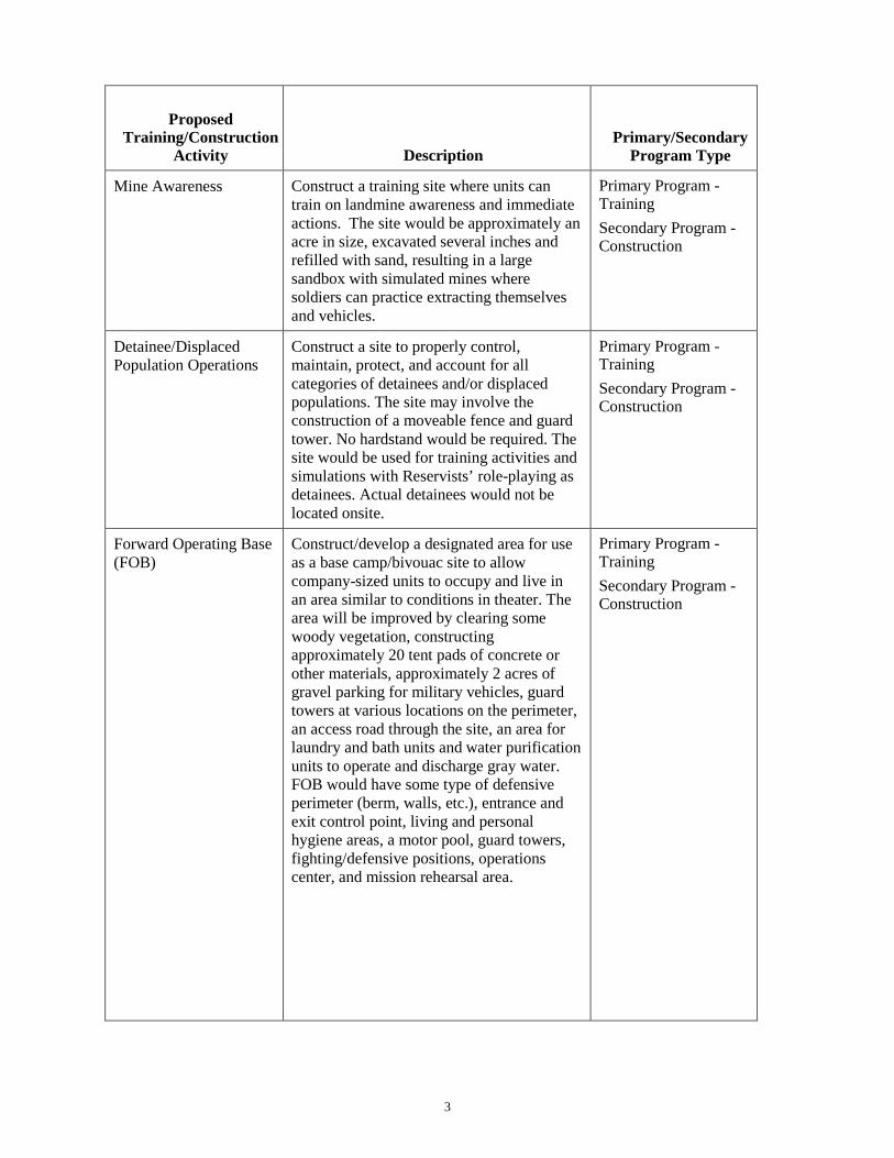
3
Proposed Training/Construction
Activity Description Primary/Secondary
Program Type
Mine Awareness Construct a training site where units can train on landmine awareness and immediate actions. The site would be approximately an acre in size, excavated several inches and refilled with sand, resulting in a large sandbox with simulated mines where soldiers can practice extracting themselves and vehicles.
Primary Program - Training Secondary Program - Construction
Detainee/Displaced Population Operations
Construct a site to properly control, maintain, protect, and account for all categories of detainees and/or displaced populations. The site may involve the construction of a moveable fence and guard tower. No hardstand would be required. The site would be used for training activities and simulations with Reservists’ role-playing as detainees. Actual detainees would not be located onsite.
Primary Program - Training Secondary Program - Construction
Forward Operating Base (FOB)
Construct/develop a designated area for use as a base camp/bivouac site to allow company-sized units to occupy and live in an area similar to conditions in theater. The area will be improved by clearing some woody vegetation, constructing approximately 20 tent pads of concrete or other materials, approximately 2 acres of gravel parking for military vehicles, guard towers at various locations on the perimeter, an access road through the site, an area for laundry and bath units and water purification units to operate and discharge gray water. FOB would have some type of defensive perimeter (berm, walls, etc.), entrance and exit control point, living and personal hygiene areas, a motor pool, guard towers, fighting/defensive positions, operations center, and mission rehearsal area.
Primary Program - Training Secondary Program - Construction

4
Proposed Training/Construction
Activity Description Primary/Secondary
Program Type
Military Operations on Urban Terrain (MOUT)
Construct urban-type area for practicing military operations in urban terrain. Two areas to simulate villages and urban terrain environment are planned. Each area will be approximately 1 acre in size. Simulated buildings, and/or building facades would be constructed out of wood, masonry block, or metal shipping containers. A simulated underground sewer system consisting of buried culvert may be installed. Soldiers would practice moving through and/or clearing these courses once constructed.
Primary Program - Training Secondary Program - Construction
Obstacle/Confidence Course
Construct an obstacle course for tactical movement, physical training, teamwork building, and problem solving skill evaluation. Typical courses include obstacles that participants would climb over, crawl under, balance, hang, jump, etc. Areas of muddy water, ropes/nets, and no touch restrictions can be used to make the course more difficult.
Primary Program - Training Secondary Program - Construction
Physical Training (PT) Track
Construct/select an area to allow tenant and visiting units to conduct physical training and a standard Army Physical Fitness Test (APFT). Requires an area for climbing bars, push-ups, sit-ups, and a measured 2-mile track.
Primary Program - Training Secondary Program - Construction
Tactical Concealment/Bivouac Area
Layout tactical concealment areas and bivouac sites to allow units to practice occupying field sites and operations in a concealed environment.
Primary Program - Training
Assault Course/Defensive Position Lanes
Design defensive positions (trench and bunker style) and establish lanes for both assault on the positions and defense of the positions. No live fire or explosives would be used. Allow units to practice being ambushed.
Primary Program - Training
Driver Training Provide for driver training of military vehicles on a variety of surfaces (i.e., dirt, gravel, paved). Train and negotiate in serpentine paths and narrow passages, straight line and serpentine backing, operation during day and night situations.
Primary Program - Training
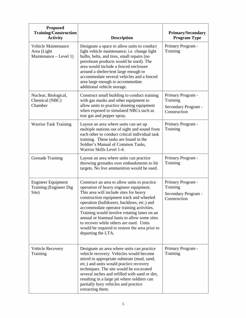
5
Proposed Training/Construction
Activity Description Primary/Secondary
Program Type
Vehicle Maintenance Area (Light Maintenance – Level 1)
Designate a space to allow units to conduct light vehicle maintenance; i.e. change light bulbs, belts, and tires, small repairs (no petroleum products would be used). The area would include a fenced enclosure around a shelter/tent large enough to accommodate several vehicles and a fenced area large enough to accommodate additional vehicle storage.
Primary Program - Training
Nuclear, Biological, Chemical (NBC) Chamber
Construct small building to conduct training with gas masks and other equipment to allow units to practice donning equipment when exposed to simulated NBCs such as tear gas and pepper spray.
Primary Program - Training Secondary Program - Construction
Warrior Task Training Layout an area where units can set up multiple stations out of sight and sound from each other to conduct critical individual task training. These tasks are found in the Soldier’s Manual of Common Tasks, Warrior Skills Level 1-4.
Primary Program - Training
Grenade Training Layout an area where units can practice throwing grenades over embankments to hit targets. No live ammunition would be used.
Primary Program - Training
Engineer Equipment Training (Engineer Dig Site)
Construct an area to allow units to practice operation of heavy engineer equipment. This area will include sites for heavy construction equipment track and wheeled operation (bulldozers, backhoes, etc.) and accommodate operator training activities. Training would involve rotating lanes on an annual or biannual basis to allow some sites to recover while others are used. Units would be required to restore the area prior to departing the LTA.
Primary Program - Training Secondary Program - Construction
Vehicle Recovery Training
Designate an area where units can practice vehicle recovery. Vehicles would become mired in appropriate substrate (mud, sand, etc.) and units would practice recovery techniques. The site would be excavated several inches and refilled with sand or dirt, resulting in a large pit where soldiers can partially bury vehicles and practice extracting them.
Primary Program - Training

6
Proposed Training/Construction
Activity Description Primary/Secondary
Program Type
Screening Trees Plant trees to create living screens, minimize erosion potential, and create wind breaks around the LTA.
Primary Program - Natural Resources
Wash Rack Facility Construct a washing facility capable of cleaning vehicles used during training prior to departing home station. May or may not be part of existing facilities.
Primary Program - Construction
Parking Areas: Military Equipment Parking (MEP) and Personally-owned Vehicles (POV).
Construct parking areas for equipment and vehicles. Likely gravel/permeable surface.
Primary Program - Construction
Helicopter Landing Zone/Pickup Zone (LZ/PZ)
Designate a helicopter LZ/PZ. Primary Program - Training
Latrines Construct LTA vault latrines. Primary Program - Construction
Modular Small Arms Range (MSAR) – contained within a building.
Obtain and utilize a MSAR to provide small arms qualification capability to units with limited or no access to live fire ranges.
Primary Program – Training Secondary Program - Construction
DEPARTMENT OF THE ARMY
HEADQUARTERS, 88TH REGIONAL SUPPORT COMMAND 60 SOUTH O STREET
FORT MCCOY, WISCONSIN 54656-5138
REPLY TO ATTENTION OF:
January 18, 2014
Directorate of Public Works Ms. Betsy Herrmann U.S. Fish and Wildlife Service Utah Ecological Services Field Office 2369 Orton Circle, Suite 50 West Valley City, Utah 84119 Dear Ms. Herrmann: The U.S. Army Reserve (USAR) 88th Regional Support Command (88th RSC) is proposing to improve the current use and future development of the activities of the existing Ogden Local Training Area (LTA). The Proposed Action is the implementation of several activities as part of three Programs: Training, Construction, and Natural Resource Management. The purpose of the Proposed Action is to provide adequate training facilities to meet the current and projected demand for training at the Ogden LTA. UT035 Ogden LTA property is located at 1380 North 1200 West, Ogden, Utah 84404. The 108.41 acre facility is used for military training. It contains no permanent structures and consists of a large open grassland/field area (grass/forb) dominated by weeds including clasping pepperweed, crossflower, crested wheatgrass, dyer’s woad and cheatgrass with several unimproved roads. Three small isolated wetland areas totaling 3.2 acres are also present within the LTA. They were dominated by perennial pepperweed, hoary cress, teasel, and broadleaf cattail. Portions of the facility are used for military equipment storage. Surrounding land use includes industrial/commercial properties, the Webber County Fairgrounds, residential development, a Veterans residential facility, and agriculture land surrounding the 88th RSC property (Enclosure 1).
On January 15, 2014, 88th RSC natural resource personnel carefully reviewed the U.S. Fish and Wildlife Service Region 6 website's IPAC list of Federally-listed Threatened, Endangered and Candidate Species for those species and critical habitats that may be present throughout the site (Enclosure 2). At the time of the review, there were 5 species identified as Endangered, Threatened, Proposed Threatened or Candidate in Webber County, Utah.
An on-site Natural Resources Survey was completed by the 88th RSC for the facility in 2013 (Enclosure 1). The survey identified no federally listed species on or in the immediate vicinity of the site. The survey also indicated that no suitable habitat for any of the 5 listed, proposed or candidate species existed on the site. There have been no known changes to the property since this survey.
For these reasons, and pursuant to 50 CFR 402 Section 7(a)(2) of the Endangered Species Act, the 88th RSC has concluded that the property disposal will have “no effect” on any federally listed threatened, endangered, proposed or candidate species, nor proposed or designated critical habitat.
If you have any questions about this determination, or require additional information, please contact Mr. Marshal Braman at (612) 713-3470 or via email at [email protected]. Please address and mail written correspondence to: 88TH RSC, ATTN: AFRC-SWI-EN (Braman), 506 Roeder Circle, Ft Snelling, MN 55111. Sincerely, David L. Moore Enclosures Chief, Public Works- Environmental Division

December 2013
Draft
NATURAL RESOURCES SURVEYS INITIAL AND UPDATES
AT SELECT 88th REGIONAL SUPPORT COMMAND (RSC)
US ARMY RESERVE CENTERS and LOCAL TRAINING AREAS IN
UTAH
Prepared for:
US Army Corps of Engineers Louisville District
600 Dr. Martin Luther King, Jr. Place Louisville, KY 40202
and
US Army Reserve 88th RSC Directorate of Public Works
60 South O Street Fort McCoy, Wisconsin 54646
Prepared by:
URS Group, Inc. 720 Park Boulevard Boise, Idaho 83712
Phone: 208.386.7608 Notice: This report has been prepared by URS Group Inc. solely for the benefit of its client
in accordance with an approved scope of work. URS Corporation assumes no liability for the unauthorized use of this report or the information contained in it by a third party.
1.1 UT035 – LTA – OGDEN (OGDEN) 1.1.1 General Description LTA – Ogden (FACID UT035, Site Code 49676) consists of an LTA and associated parking areas. The facility provides military training. The 88th RSC owns the land that comprises UT035. Photographs and video clips were collected during the 2013 field visit. Locations of the photographs and video clips are depicted on the UT035 Photo Map and photographs are displayed in the Photo Log. 1.1.2 Geographic Location and Size Facility UT035 is located in Ogden, population 82,825, within Weber County. Acreage for the facility was indicated at 85.40 acres based on the property boundary provided by the RSC. The 17 September 2013 Real Property Detail Report shows acreage as 108.41 acres. In the field the property was calculated at 108.40 acres by GIS. Surrounding land use consists of light industrial land to the south, undeveloped land, ball field, and fairground to the east, and residential land to the west. Facility UT007 and residential land is located to the north of UT035. The facility boundaries are shown on the UT035 Facility Map. The boundary provided for the 2013 survey differed from the previous 2008 survey boundary; it was approximately 23 acres less in size. The 23 acres not included in the 2008 boundary are adjacent to the facility, directly east. Through communication with the POC, Edward Minnig, the area excluded from the 2008 survey is currently being used as part of UT035. During the 2013 survey, this area was being developed into a parking area and construction crews were onsite. 1.1.3 Geological Resources 1.1.3.1 Physiography and Geology This facility is located within the Basin and Range physiographic province (Fenneman and Johnson 1946a). This province is characterized by a mosaic of dry basins, scattered mountains, and salt flats (Fenneman and Johnson 1946b). It is noted for numerous north-south oriented, fault-tilted mountain ranges separated by intervening, broad, sediment filled basins. Geological formations at UT035 are Quaternary formations (Hintze et al. 2000). 1.1.3.2 Soils Mapped soils within the facility are classified by the NRCS as Urban Land (NRCS 2008c). The soil map units within and immediately adjacent to the facility boundaries are shown in the UT035 Soil Map. 1.1.3.3 Topography
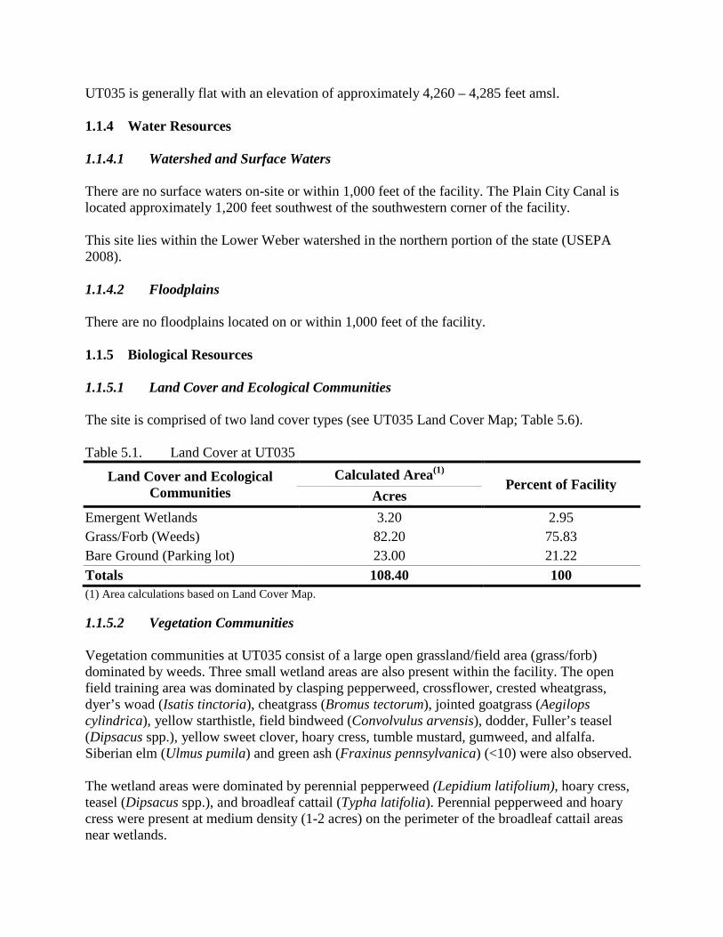
UT035 is generally flat with an elevation of approximately 4,260 – 4,285 feet amsl. 1.1.4 Water Resources 1.1.4.1 Watershed and Surface Waters There are no surface waters on-site or within 1,000 feet of the facility. The Plain City Canal is located approximately 1,200 feet southwest of the southwestern corner of the facility. This site lies within the Lower Weber watershed in the northern portion of the state (USEPA 2008). 1.1.4.2 Floodplains There are no floodplains located on or within 1,000 feet of the facility. 1.1.5 Biological Resources 1.1.5.1 Land Cover and Ecological Communities The site is comprised of two land cover types (see UT035 Land Cover Map; Table 5.6). Table 5.1. Land Cover at UT035
Land Cover and Ecological Communities
Calculated Area(1) Percent of Facility
Acres Emergent Wetlands 3.20 2.95 Grass/Forb (Weeds) 82.20 75.83 Bare Ground (Parking lot) 23.00 21.22 Totals 108.40 100 (1) Area calculations based on Land Cover Map. 1.1.5.2 Vegetation Communities Vegetation communities at UT035 consist of a large open grassland/field area (grass/forb) dominated by weeds. Three small wetland areas are also present within the facility. The open field training area was dominated by clasping pepperweed, crossflower, crested wheatgrass, dyer’s woad (Isatis tinctoria), cheatgrass (Bromus tectorum), jointed goatgrass (Aegilops cylindrica), yellow starthistle, field bindweed (Convolvulus arvensis), dodder, Fuller’s teasel (Dipsacus spp.), yellow sweet clover, hoary cress, tumble mustard, gumweed, and alfalfa. Siberian elm (Ulmus pumila) and green ash (Fraxinus pennsylvanica) (<10) were also observed. The wetland areas were dominated by perennial pepperweed (Lepidium latifolium), hoary cress, teasel (Dipsacus spp.), and broadleaf cattail (Typha latifolia). Perennial pepperweed and hoary cress were present at medium density (1-2 acres) on the perimeter of the broadleaf cattail areas near wetlands.
1.1.5.3 Invasive Species Invasive species are the dominant vegetation within the facility. The open field training area was dominated by dyer’s woad (Isatis tinctoria), cheatgrass (Bromus tectorum), jointed goatgrass (Aegilops cylindrica), yellow starthistle, field bindweed (Convolvulus arvensis), hoary cress, and perennial pepperweed. The invasive species recorded were present locally at high densities as they dominated the grass/forb (weed) area. 1.1.5.4 Wetlands Vernadero (2004f) documented three potential wetland areas at UT035. The "main ditch wetland" described by Vernadero (2004f) was not identified as a wetland during the August 7, 2008 or the June 11, 2013 surveys. On June 11, 2013, URS identified three wetland areas within the facility (see UT035 Land Cover Map). Two small seasonally-flooded palustrine emergent wetlands (PEMC) were documented in the northeastern portion of the facility, each measuring just over 0.1 acres. The third wetland was documented in the southwestern portion of the facility. This palustrine emergent semi-permanently flooded (PEMF) wetland area is fenced off from the rest of the facility. It measures less than 3 acres. The two small wetlands in the northern portion of the facility are dominated by broadleaf cattail and mesic graminoids. The larger wetland to the south is dominated by broadleaf cattail, hoary cress, and perennial pepperweed. The two small wetland areas were dry and no standing water was observed at the time of the 2008 and 2013 surveys. Standing water was present in the larger wetland in the southern portion of the facility in 2013.
The soils in the facility are mapped as Urban Land, and as such, they do not have a hydric designation. Based on the plants, soils, and hydrology of the three wetlands, URS cannot rule out the larger, southern wetland as a potentially jurisdictional wetland regulated by the USACE. The two smaller wetlands in the northeast are not likely jurisdictional; however, final jurisdiction determination is a decision made by the USACE.
According to NWI data, there are three seasonally-flooded palustrine emergent wetlands (PEMCs) immediately adjacent to, approximately 200 feet east of, and approximately 850 feet east of the eastern boundary of UT035. These wetlands are depicted on the UT035 Facility Map. 1.1.5.5 Wildlife The open grass/forb field and wetland areas of the facility may provide limited habitat for wildlife species. However, due to the overall developed nature of the facility and the surrounding land use, only common wildlife species adapted to such areas are likely to utilize this property. The open land of the facility provides resting habitat for migratory birds. Migratory birds were not observed during the survey. Eagles are not likely to utilize the facility due to close proximity to developed land. Wildlife observed on the facility by URS during the 2013 facility survey included: mourning dove (Zenaida macroura), Eurasian collard-dove (Streptopelia decaocto), black-billed magpie
(Pica hudsonia), European starling (Sturnus vulgaris), cliff swallow (Petrochelidon pyrrhonota), American robin (Turdus migratorius), American crow (Corvus brachyrhynchos), house finch (Carpodacus mexicanus), western kingbird (Tyrannus verticalis), turkey vulture (Cathartes aura), osprey (Pandion haliaetus), American kestrel (Falco sparverius), Swainson’s hawk (Buteo swainsoni), and an unknown gull species (Larus spp.). 1.1.5.6 Listed Species No federal or state listed species were observed on or within 1,000 feet of facility UT035 during the field survey. No suitable habitat for listed species was observed on the facility. The USFWS (2013) lists the following species in Weber County: Canada lynx (Lynx canadensis) T), June sucker (Chasmistes liorusv E), greater sage-grouse (Centrocercus urophasianus C), and yellow-billed cuckoo (Coccyzus americanus C). The electronic GIS data provided by the Utah Natural Heritage Program (UDNR 2013) indicated that there have been no state listed species documented within the facility or 1,000 feet of UT035. Additional state listed species in Weber County are provided in Appendix B. 1.1.5.7 Special Interest Areas No special interest areas occur within 1,000 feet of the facility. 1.1.6 Management Issues and Concerns Where practicable, impacts to wetlands should be avoided. Unavoidable impacts will be assessed and properly mitigated. Measures have been taken to avoid impacts to the wetland in the southern portion of the facility; this area has been fenced. Invasive species are the dominant vegetation at this facility. Several Utah State Noxious Weeds were recorded here, which included: field bindweed (Convolvulus arvensis), hoary cress, dyer’s woad (Isatis tinctoria), cheatgrass (Bromus tectorum), jointed goatgrass (Aegilops cylindrica), yellow starthistle and perennial pepperweed. Invasive species and noxious weeds are a management concern at this facility. Treatment of noxious weeds and invasive plants should be accomplished through mechanical (physical removal) and/or chemical (herbicides) means. Application of herbicides in quantities obtainable from local suppliers is not regulated. Green ash trees may be at risk from the emerald ash borer if this insect spreads to Utah in the future. Tree health should be monitored annually by visual inspection of tree damage to detect the presence of the emerald ash borer. If ash trees appear in poor health or damaged, visit http://www.emeraldashborer.info for details on identification, treatment and control.
As of September 2013 the closest known detection of the emerald ash borer is Boulder, Colorado. In FY18, update the Natural Resources surveys completed by URS in 2013.
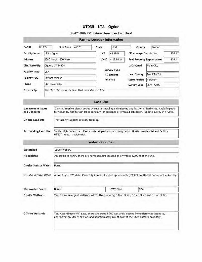
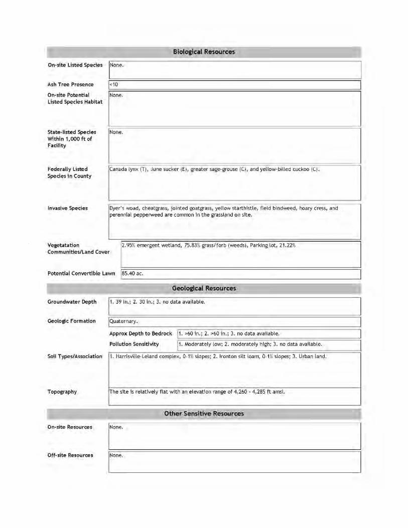
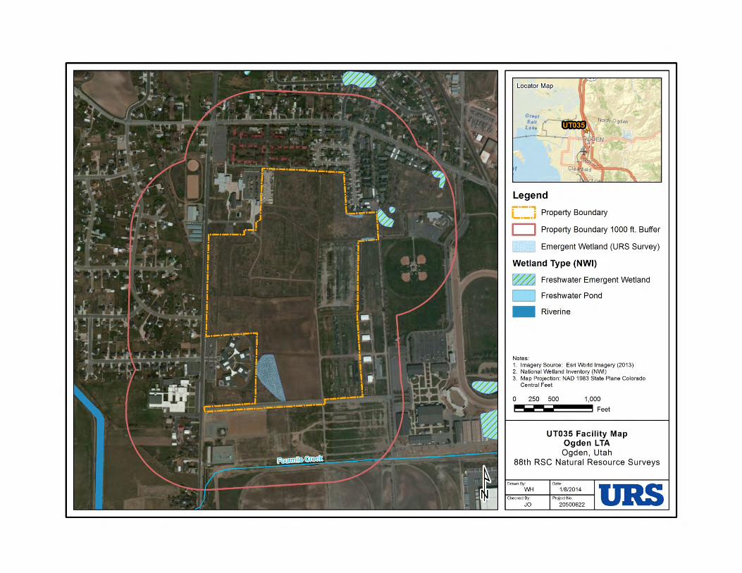
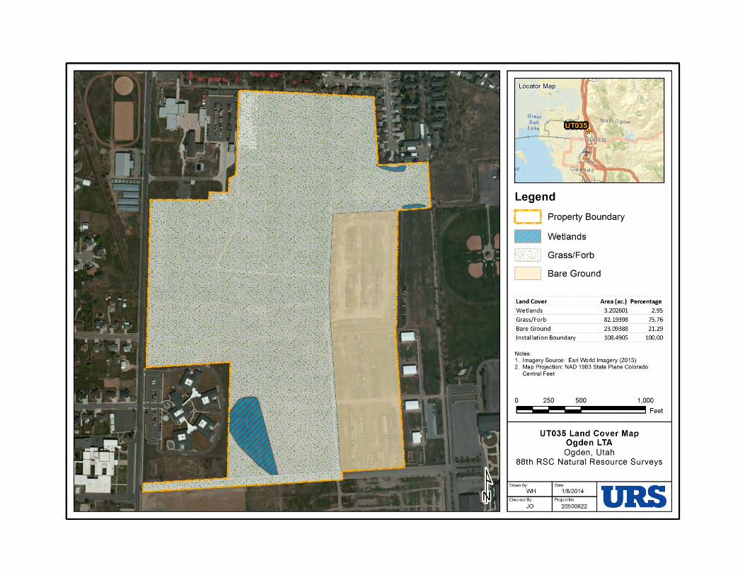
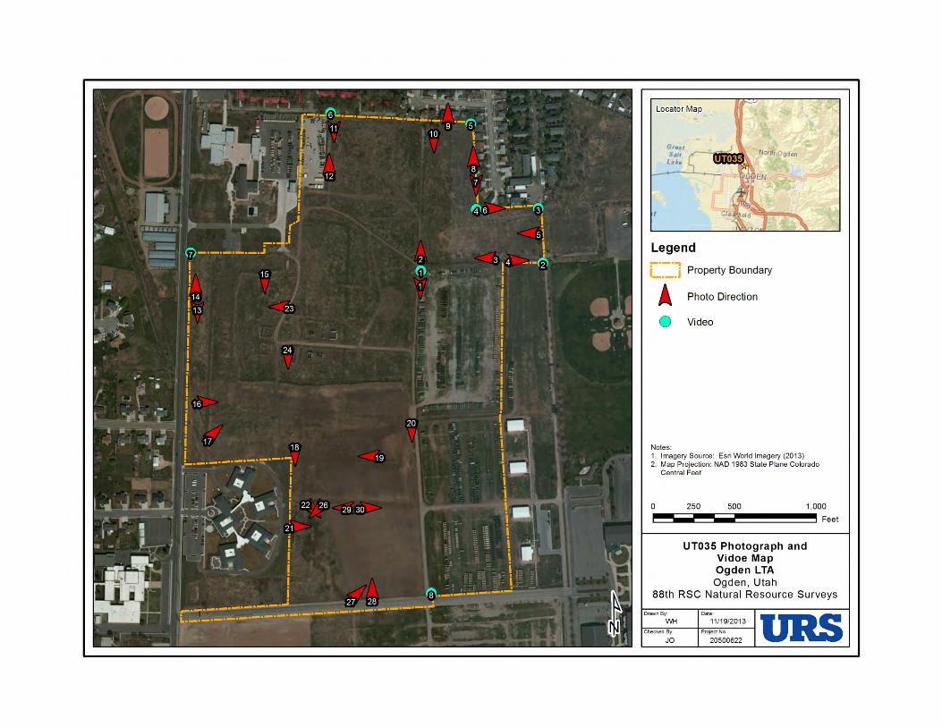
United States Department of the InteriorFISH AND WILDLIFE SERVICE
UTAH ECOLOGICAL SERVICES FIELD OFFICE2369 WEST ORTON CIRCLE, SUITE 50
WEST VALLEY CITY, UT 84119PHONE: (801)975-3330 FAX: (801)975-3331
URL: www.fws.gov; www.fws.gov/utahfieldoffice/
Consultation Tracking Number: 06E23000-2014-SLI-0049 January 15, 2014Project Name: Construction and training activities at Ogden LTA
Subject: List of threatened and endangered species that may occur in your proposed projectlocation, and/or may be affected by your proposed project.
To Whom It May Concern:
The enclosed species list identifies threatened, endangered, and proposed species, designatedcritical habitat, and candidate species that may occur within the boundary of your proposedproject and/or may be affected by your proposed project. The species list fulfills therequirements of the U.S. Fish and Wildlife Service (Service) under section 7(c) of theEndangered Species Act (Act) of 1973, as amended (16 U.S.C. 1531 ).et seq.
New information based on updated surveys, changes in the abundance and distribution ofspecies, changed habitat conditions, or other factors could change this list. Please feel free tocontact us if you need more current information or assistance regarding the potential impacts tofederally proposed, listed, and candidate species and federally designated and proposed criticalhabitat. Please note that under 50 CFR 402.12(e) of the regulations implementing section 7 ofthe Act, the accuracy of this species list should be verified after 90 days. This verification canbe completed formally or informally as desired. The Service recommends that verification becompleted by visiting the ECOS-IPaC website at regular intervals during project planning andimplementation for updates to species lists and information. An updated list may be requestedthrough the ECOS-IPaC system by completing the same process used to receive the enclosedlist.
The purpose of the Act is to provide a means whereby threatened and endangered species andthe ecosystems upon which they depend may be conserved. Under sections 7(a)(1) and 7(a)(2)of the Act and its implementing regulations (50 CFR 402 ), Federal agencies are requiredet seq.to utilize their authorities to carry out programs for the conservation of threatened andendangered species and to determine whether projects may affect threatened and endangeredspecies and/or designated critical habitat.
A Biological Assessment is required for construction projects (or other undertakings having
similar physical impacts) that are major Federal actions significantly affecting the quality of thehuman environment as defined in the National Environmental Policy Act (42 U.S.C. 4332(2)(c)). For projects other than major construction activities, the Service suggests that a biologicalevaluation similar to a Biological Assessment be prepared to determine whether the project mayaffect listed or proposed species and/or designated or proposed critical habitat. Recommendedcontents of a Biological Assessment are described at 50 CFR 402.12.
If a Federal agency determines, based on the Biological Assessment or biological evaluation,that listed species and/or designated critical habitat may be affected by the proposed project, theagency is required to consult with the Service pursuant to 50 CFR 402. In addition, the Servicerecommends that candidate species, proposed species and proposed critical habitat be addressedwithin the consultation. More information on the regulations and procedures for section 7consultation, including the role of permit or license applicants, can be found in the "EndangeredSpecies Consultation Handbook" at:
http://www.fws.gov/endangered/esa-library/pdf/TOC-GLOS.PDF
Please be aware that bald and golden eagles are protected under the Bald and Golden EagleProtection Act (16 U.S.C. 668 ), and projects affecting these species may requireet seq.development of an eagle conservation plan(http://www.fws.gov/windenergy/eagle_guidance.html). Additionally, wind energy projectsshould follow the wind energy guidelines (http://www.fws.gov/windenergy/) for minimizingimpacts to migratory birds and bats.
Guidance for minimizing impacts to migratory birds for projects including communicationstowers (e.g., cellular, digital television, radio, and emergency broadcast) can be found at:http://www.fws.gov/migratorybirds/CurrentBirdIssues/Hazards/towers/towers.htm;http://www.towerkill.com; andhttp://www.fws.gov/migratorybirds/CurrentBirdIssues/Hazards/towers/comtow.html.
We appreciate your concern for threatened and endangered species. The Service encouragesFederal agencies to include conservation of threatened and endangered species into their projectplanning to further the purposes of the Act. Please include the Consultation Tracking Number inthe header of this letter with any request for consultation or correspondence about your projectthat you submit to our office.
Attachment
2
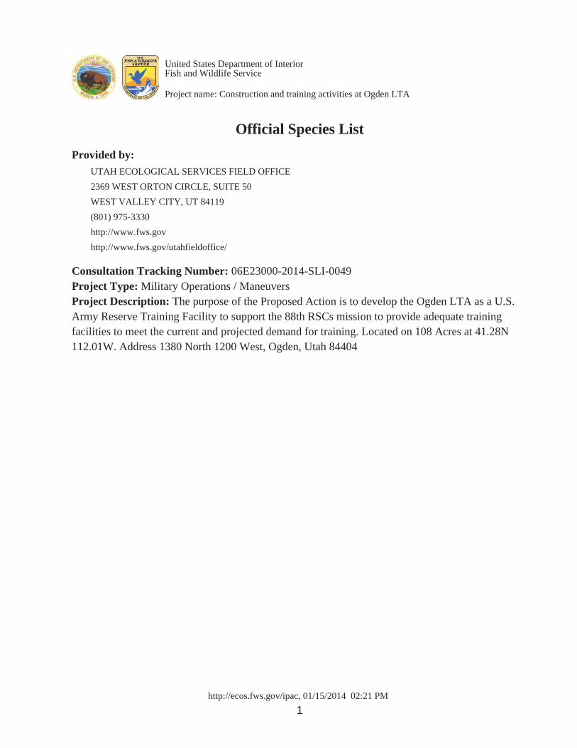
http://ecos.fws.gov/ipac, 01/15/2014 02:21 PM1
Official Species ListProvided by:
UTAH ECOLOGICAL SERVICES FIELD OFFICE2369 WEST ORTON CIRCLE, SUITE 50WEST VALLEY CITY, UT 84119(801) 975-3330http://www.fws.govhttp://www.fws.gov/utahfieldoffice/
Consultation Tracking Number: 06E23000-2014-SLI-0049Project Type: Military Operations / ManeuversProject Description: The purpose of the Proposed Action is to develop the Ogden LTA as a U.S.Army Reserve Training Facility to support the 88th RSCs mission to provide adequate trainingfacilities to meet the current and projected demand for training. Located on 108 Acres at 41.28N112.01W. Address 1380 North 1200 West, Ogden, Utah 84404
United States Department of InteriorFish and Wildlife Service
Project name: Construction and training activities at Ogden LTA
http://ecos.fws.gov/ipac, 01/15/2014 02:21 PM2
Project Counties: Weber, UT
United States Department of InteriorFish and Wildlife Service
Project name: Construction and training activities at Ogden LTA
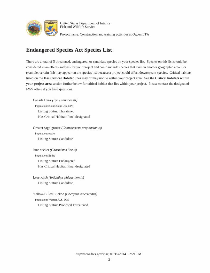
http://ecos.fws.gov/ipac, 01/15/2014 02:21 PM3
Endangered Species Act Species List
There are a total of 5 threatened, endangered, or candidate species on your species list. Species on this list should beconsidered in an effects analysis for your project and could include species that exist in another geographic area. Forexample, certain fish may appear on the species list because a project could affect downstream species. Critical habitatslisted on the Has Critical Habitat lines may or may not lie within your project area. See the Critical habitats withinyour project area section further below for critical habitat that lies within your project. Please contact the designatedFWS office if you have questions.
Canada Lynx (Lynx canadensis) Population: (Contiguous U.S. DPS)
Listing Status: Threatened Has Critical Habitat: Final designated
Greater sage-grouse (Centrocercus urophasianus) Population: entire
Listing Status: Candidate
June sucker (Chasmistes liorus) Population: Entire
Listing Status: Endangered Has Critical Habitat: Final designated
Least chub (Iotichthys phlegethontis) Listing Status: Candidate
Yellow-Billed Cuckoo (Coccyzus americanus) Population: Western U.S. DPS
Listing Status: Proposed Threatened
United States Department of InteriorFish and Wildlife Service
Project name: Construction and training activities at Ogden LTA
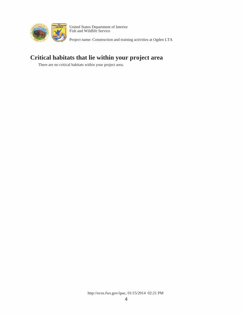
http://ecos.fws.gov/ipac, 01/15/2014 02:21 PM4
Critical habitats that lie within your project areaThere are no critical habitats within your project area.
United States Department of InteriorFish and Wildlife Service
Project name: Construction and training activities at Ogden LTA
DEPARTMENT OF THE ARMYHEADQUARTERS, 88TH REGIONAL SUPPORT COMMAND
60 SOUTH O STREETFORT MCCOY, WISCONSIN 54656
REPLY TOATTENTION OF
December 19, 2013
Directorate of Public Works
Chris Hansen300 S. Rio Grande StreetSalt Lake City, Utah 84101Phone: 801-245-7239Fax: 801-533-3503
Dear Mr. Hansen:
The 88th Regional Support Command (RSC) owns the Ogden Local Training Area (LTA), consisting of 143-acres, located approximately 5 miles northwest of the city of Ogden, and approximately 1 mile east of Interstate 15 and 84 (enclosure 1). The Ogden LTA is bounded on the west by 1200 West Street (Tomlinson Road), on the south by Bill Bailey Boulevard and the former Defense Depot Ogden, on the North bythe Frank M. Browning U.S. Army Reserve Center and private residences, and on the east by 750 West Street (Depot Drive) and the Weber County Fairgrounds. This is the initial notification that the 88th RSC is in the process of preparing a Programmatic Environmental Assessment (PEA) in support of a variety of improvements to the current use and future development at the Ogden LTA.
The proposed action is to provide adequate training facilities to meet the current and projected demand for training at the Ogden LTA, which involves implementing along-term master plan of Training, Construction, and Natural Resources Management activities as specified in Table 1 (enclosure 2). Not all types of training activities would be conducted on each training weekend. Although all training activities would occur at the Ogden LTA, it is not possible to conduct all types of training simultaneously.
In 2004, SWCA Environmental Consultants carried out a Class III Cultural Resources Inventory of the Ogden LTA (and adjacent Browning Army Reserve Center).The intent of the investigation was three-fold. The first step was to identify any known and documented cultural resources in or immediately adjacent of the LTA. The second step was to carry out a pedestrian inventory to determine if any undocumented cultural resources would be impacted by current operations conducted at the LTA or by future proposed construction or maintenance. The third intent was to assess if any actions undertaken at the LTA would affect the eligibility of archaeological resources within one mile of the LTA. SWCA had recommended that the two archaeological sites that were identified during the Class I and III cultural resources inventory and the resultant test
excavations were not eligible for the NRHP. SWCA also concluded that although it ispossible that significant prehistoric or historical cultural resources may be buried beneath the existing ground surface, investigations of sediments exposed during the test excavations as well as those materials available at the ground surface, have not resulted in the identification of such significant materials. Mr. Dykmann, Deputy Utah SHPO, responded in January 2005 with a concurrence on the Army’s determinations of eligibility and that the report met SOI Standards for Archeological Reports.
Due to the past disturbances at the property and based on review of the findings from the 2004 cultural resources inventory, the 88th RSC has determined that no adverse effects will result from the proposed undertakings and no historic properties will be affected. However, should cultural materials be discovered during any of the LTA activities as described in Table 1, work shall cease immediately and contact will be made with the Utah State Archaeologist.
Pursuant to 36 CFR 800.4(a)(ii), we would appreciate your comments on our determination for this undertaking. If we do not hear from you within thirty days, we will assume that you concur with our determination and will proceed as discussed above. If you require additional information, please contact Ms. Meline Skeldon at (425) 354-2497 or by email at [email protected].
Sincerely,
David L. MooreChief, Public Works- Environmental Division
Enclosures

2.0 DESCRIPTION OF THE PROPOSED ACTION AND ALTERNATIVES
FINAL DOPAA: OGDEN LTA USACE SEPTEMBER 2013 LOUISVILLE DISTRICT
4
FIGURE 1. General Site Location of the Ogden Local Training Area, Ogden, Weber County, Utah
Not to scale
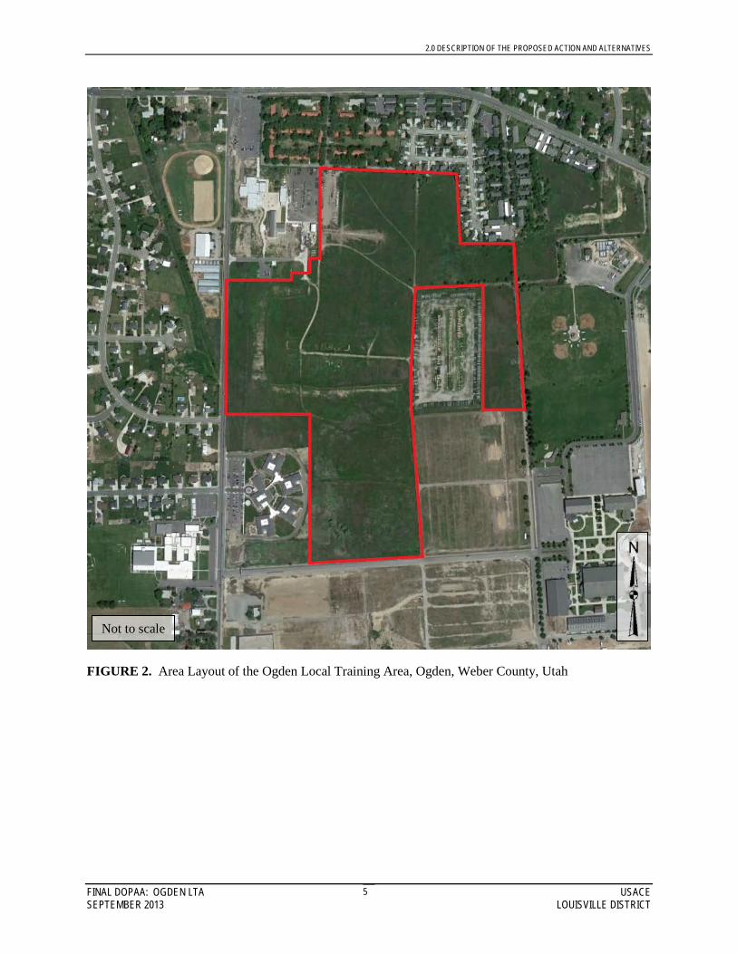
2.0 DESCRIPTION OF THE PROPOSED ACTION AND ALTERNATIVES
FINAL DOPAA: OGDEN LTA USACE SEPTEMBER 2013 LOUISVILLE DISTRICT
5
FIGURE 2. Area Layout of the Ogden Local Training Area, Ogden, Weber County, Utah
Not to scale
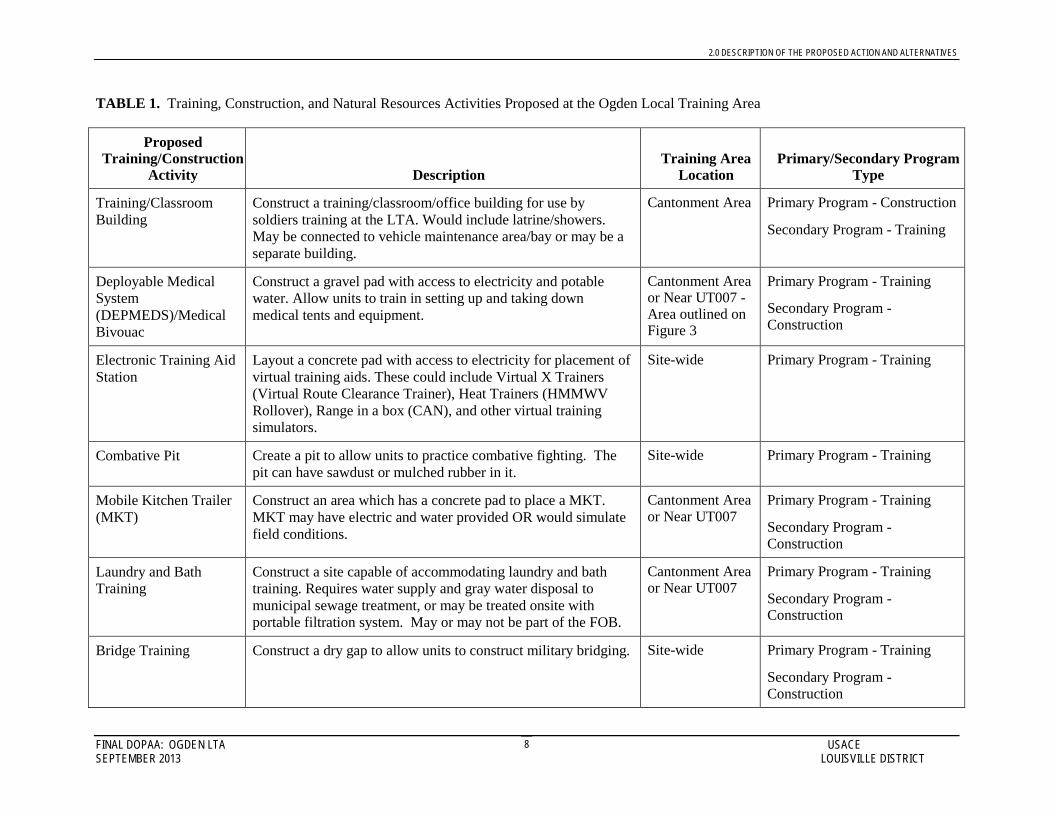
2.0 DESCRIPTION OF THE PROPOSED ACTION AND ALTERNATIVES
FINAL DOPAA: OGDEN LTA USACE SEPTEMBER 2013 LOUISVILLE DISTRICT
8
TABLE 1. Training, Construction, and Natural Resources Activities Proposed at the Ogden Local Training Area
Proposed Training/Construction
Activity Description Training Area
Location Primary/Secondary Program
Type
Training/Classroom Building
Construct a training/classroom/office building for use by soldiers training at the LTA. Would include latrine/showers. May be connected to vehicle maintenance area/bay or may be a separate building.
Cantonment Area Primary Program - Construction
Secondary Program - Training
Deployable Medical System (DEPMEDS)/Medical Bivouac
Construct a gravel pad with access to electricity and potable water. Allow units to train in setting up and taking down medical tents and equipment.
Cantonment Area or Near UT007 - Area outlined on Figure 3
Primary Program - Training
Secondary Program - Construction
Electronic Training Aid Station
Layout a concrete pad with access to electricity for placement of virtual training aids. These could include Virtual X Trainers (Virtual Route Clearance Trainer), Heat Trainers (HMMWV Rollover), Range in a box (CAN), and other virtual training simulators.
Site-wide Primary Program - Training
Combative Pit Create a pit to allow units to practice combative fighting. The pit can have sawdust or mulched rubber in it.
Site-wide Primary Program - Training
Mobile Kitchen Trailer (MKT)
Construct an area which has a concrete pad to place a MKT. MKT may have electric and water provided OR would simulate field conditions.
Cantonment Area or Near UT007
Primary Program - Training
Secondary Program - Construction
Laundry and Bath Training
Construct a site capable of accommodating laundry and bath training. Requires water supply and gray water disposal to municipal sewage treatment, or may be treated onsite with portable filtration system. May or may not be part of the FOB.
Cantonment Area or Near UT007
Primary Program - Training
Secondary Program - Construction
Bridge Training Construct a dry gap to allow units to construct military bridging. Site-wide Primary Program - Training
Secondary Program - Construction
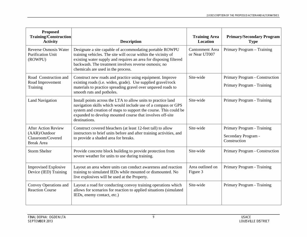
2.0 DESCRIPTION OF THE PROPOSED ACTION AND ALTERNATIVES
FINAL DOPAA: OGDEN LTA USACE SEPTEMBER 2013 LOUISVILLE DISTRICT
9
Proposed Training/Construction
Activity Description Training Area
Location Primary/Secondary Program
Type
Reverse Osmosis Water Purification Unit (ROWPU)
Designate a site capable of accommodating portable ROWPU training vehicles. The site will occur within the vicinity of existing water supply and requires an area for disposing filtered backwash. The treatment involves reverse osmosis; no chemicals are used in the process.
Cantonment Area or Near UT007
Primary Program – Training
Road Construction and Road Improvement Training
Construct new roads and practice using equipment. Improve existing roads (i.e. widen, grade). Use supplied gravel/rock materials to practice spreading gravel over unpaved roads to smooth ruts and potholes.
Site-wide Primary Program - Construction
Primary Program - Training
Land Navigation Install points across the LTA to allow units to practice land navigation skills which would include use of a compass or GPS system and creation of maps to support the course. This could be expanded to develop mounted course that involves off-site destinations.
Site-wide Primary Program - Training
After Action Review (AAR)/Outdoor Classroom/Covered Break Area
Construct covered bleachers (at least 12-feet tall) to allow instructors to brief units before and after training activities, and to provide a shaded area for breaks.
Site-wide Primary Program - Training
Secondary Program - Construction
Storm Shelter Provide concrete block building to provide protection from severe weather for units to use during training.
Site-wide Primary Program - Construction
Improvised Explosive Device (IED) Training
Layout an area where units can conduct awareness and reaction training to simulated IEDs while mounted or dismounted. No live explosives will be used at the Property.
Area outlined on Figure 3
Primary Program - Training
Convoy Operations and Reaction Course
Layout a road for conducting convoy training operations which allows for scenarios for reaction to applied situations (simulated IEDs, enemy contact, etc.)
Site-wide Primary Program - Training
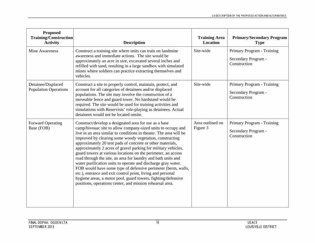
2.0 DESCRIPTION OF THE PROPOSED ACTION AND ALTERNATIVES
FINAL DOPAA: OGDEN LTA USACE SEPTEMBER 2013 LOUISVILLE DISTRICT
10
Proposed Training/Construction
Activity Description Training Area
Location Primary/Secondary Program
Type
Mine Awareness Construct a training site where units can train on landmine awareness and immediate actions. The site would be approximately an acre in size, excavated several inches and refilled with sand, resulting in a large sandbox with simulated mines where soldiers can practice extracting themselves and vehicles.
Site-wide Primary Program - Training
Secondary Program - Construction
Detainee/Displaced Population Operations
Construct a site to properly control, maintain, protect, and account for all categories of detainees and/or displaced populations. The site may involve the construction of a moveable fence and guard tower. No hardstand would be required. The site would be used for training activities and simulations with Reservists’ role-playing as detainees. Actual detainees would not be located onsite.
Site-wide Primary Program - Training
Secondary Program - Construction
Forward Operating Base (FOB)
Construct/develop a designated area for use as a base camp/bivouac site to allow company-sized units to occupy and live in an area similar to conditions in theater. The area will be improved by clearing some woody vegetation, constructing approximately 20 tent pads of concrete or other materials, approximately 2 acres of gravel parking for military vehicles, guard towers at various locations on the perimeter, an access road through the site, an area for laundry and bath units and water purification units to operate and discharge gray water. FOB would have some type of defensive perimeter (berm, walls, etc.), entrance and exit control point, living and personal hygiene areas, a motor pool, guard towers, fighting/defensive positions, operations center, and mission rehearsal area.
Area outlined on Figure 3
Primary Program - Training
Secondary Program - Construction

2.0 DESCRIPTION OF THE PROPOSED ACTION AND ALTERNATIVES
FINAL DOPAA: OGDEN LTA USACE SEPTEMBER 2013 LOUISVILLE DISTRICT
11
Proposed Training/Construction
Activity Description Training Area
Location Primary/Secondary Program
Type
Military Operations on Urban Terrain (MOUT)
Construct urban-type area for practicing military operations in urban terrain. Two areas to simulate villages and urban terrain environment are planned. Each area will be approximately 1 acre in size. Simulated buildings, and/or building facades would be constructed out of wood, masonry block, or metal shipping containers. A simulated underground sewer system consisting of buried culvert may be installed. Soldiers would practice moving through and/or clearing these courses once constructed.
Area outlined on Figure 3
Primary Program - Training
Secondary Program - Construction
Obstacle/Confidence Course
Construct an obstacle course for tactical movement, physical training, teamwork building, and problem solving skill evaluation. Typical courses include obstacles that participants would climb over, crawl under, balance, hang, jump, etc. Areas of muddy water, ropes/nets, and no touch restrictions can be used to make the course more difficult.
Area outlined on Figure 3
Primary Program - Training
Secondary Program - Construction
Physical Training (PT) Track
Construct/select an area to allow tenant and visiting units to conduct physical training and a standard Army Physical Fitness Test (APFT). Requires an area for climbing bars, push-ups, sit-ups, and a measured 2-mile track.
Area outlined on Figure 3
Primary Program - Training
Secondary Program - Construction
Tactical Concealment/Bivouac Area
Layout tactical concealment areas and bivouac sites to allow units to practice occupying field sites and operations in a concealed environment.
Site-wide Primary Program - Training
Assault Course/Defensive Position Lanes
Design defensive positions (trench and bunker style) and establish lanes for both assault on the positions and defense of the positions. No live fire or explosives would be used. Allow units to practice being ambushed.
Site-wide Primary Program - Training
Driver Training Provide for driver training of military vehicles on a variety of surfaces (i.e., dirt, gravel, paved). Train and negotiate in serpentine paths and narrow passages, straight line and serpentine backing, operation during day and night situations.
Area outlined on Figure 3
Primary Program - Training

2.0 DESCRIPTION OF THE PROPOSED ACTION AND ALTERNATIVES
FINAL DOPAA: OGDEN LTA USACE SEPTEMBER 2013 LOUISVILLE DISTRICT
12
Proposed Training/Construction
Activity Description Training Area
Location Primary/Secondary Program
Type
Vehicle Maintenance Area (Light Maintenance – Level 1)
Designate a space to allow units to conduct light vehicle maintenance; i.e. change light bulbs, belts, and tires, small repairs (no petroleum products would be used). The area would include a fenced enclosure around a shelter/tent large enough to accommodate several vehicles and a fenced area large enough to accommodate additional vehicle storage.
Site-wide Primary Program - Training
Nuclear, Biological, Chemical (NBC) Chamber
Construct small building to conduct training with gas masks and other equipment to allow units to practice donning equipment when exposed to simulated NBCs such as tear gas and pepper spray.
Site-wide Primary Program - Training
Secondary Program - Construction
Warrior Task Training Layout an area where units can set up multiple stations out of sight and sound from each other to conduct critical individual task training. These tasks are found in the Soldier’s Manual of Common Tasks, Warrior Skills Level 1-4.
Site-wide Primary Program - Training
Grenade Training Layout an area where units can practice throwing grenades over embankments to hit targets. No live ammunition would be used.
Site-wide Primary Program - Training
Engineer Equipment Training (Engineer Dig Site)
Construct an area to allow units to practice operation of heavy engineer equipment. This area will include sites for heavy construction equipment track and wheeled operation (bulldozers, backhoes, etc.) and accommodate operator training activities. Training would involve rotating lanes on an annual or biannual basis to allow some sites to recover while others are used. Units would be required to restore the area prior to departing the LTA.
Area outlined on Figure 3
Primary Program - Training
Secondary Program - Construction
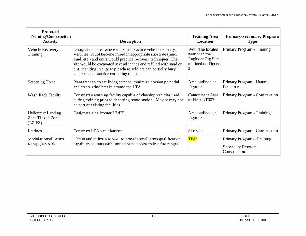
2.0 DESCRIPTION OF THE PROPOSED ACTION AND ALTERNATIVES
FINAL DOPAA: OGDEN LTA USACE SEPTEMBER 2013 LOUISVILLE DISTRICT
13
Proposed Training/Construction
Activity Description Training Area
Location Primary/Secondary Program
Type
Vehicle Recovery Training
Designate an area where units can practice vehicle recovery. Vehicles would become mired in appropriate substrate (mud, sand, etc.) and units would practice recovery techniques. The site would be excavated several inches and refilled with sand or dirt, resulting in a large pit where soldiers can partially bury vehicles and practice extracting them.
Would be located near or in the Engineer Dig Site outlined on Figure 3
Primary Program - Training
Screening Trees Plant trees to create living screens, minimize erosion potential, and create wind breaks around the LTA.
Area outlined on Figure 3
Primary Program - Natural Resources
Wash Rack Facility Construct a washing facility capable of cleaning vehicles used during training prior to departing home station. May or may not be part of existing facilities.
Cantonment Area or Near UT007
Primary Program - Construction
Helicopter Landing Zone/Pickup Zone (LZ/PZ)
Designate a helicopter LZ/PZ. Area outlined on Figure 3
Primary Program - Training
Latrines Construct LTA vault latrines. Site-wide Primary Program - Construction
Modular Small Arms Range (MSAR)
Obtain and utilize a MSAR to provide small arms qualification capability to units with limited or no access to live fire ranges.
TBD Primary Program – Training
Secondary Program - Construction

2.0 DESCRIPTION OF THE PROPOSED ACTION AND ALTERNATIVES
FINAL DOPAA: OGDEN LTA USACE SEPTEMBER 2013 LOUISVILLE DISTRICT
6
FIGURE 3. Proposed Locations for Training Facilities for the Ogden Local Training Area
Not to scale
Class III Archaeological Inventory and Test Excavations at Browning US Army Reserve Center and Local Training Area in Weber County, Utah
Prepared for
US Army Reserve, 96th Regional Readiness Command
Prepared by
SWCA Environmental Consultants
12 June 2007

CLASS III ARCHAEOLOGICAL INVENTORY AND TEST EXCAVATIONS AT BROWNING U.S. ARMY RESERVE CENTER
AND LOCAL TRAINING AREA IN WEBER COUNTY, UTAH
Prepared for: U.S. Army Reserve 96th Regional Readiness
Command
Submitted to: U.S. Army Reserve 96th Regional Readiness
Command Fort Douglas AFRC, Building 102
Salt Lake City, UT 84113-5007
Prepared by: Sonia Hutmacher Cunningham, M.A., R.P.A.
With contributions by:
Jason Green Jim Christensen Rachael Gruis
SWCA® Environmental Consultants
230 South 500 East Suite 380 Salt Lake City, UT 84102
801-322-4307
State Antiquities Project No. U-04-ST-1262 SWCA Project No. 7419-087
SWCA Cultural Resources Report No. 2004-389
Tuesday, June 12, 2007
Archaeological Investigations and Test Excavations at Browning USARC and LTA in Weber County, Utah 28-Oct-04
ABSTRACT
In November 2003, the United States Army Reserve (USAR), 96th Regional Readiness Command (RRC) requested that SWCA, Inc. Environmental Consultants (SWCA) conduct cultural resources inventories of US Army Reserve facilities located within the command’s Area of Operations. The purpose of these inventories is to maintain the 96th RRC's compliance with Sections 106, 110, and 111 of the National Historic Preservation of 1966 (NHPA). This involves the identification, evaluation, and nomination of all historic properties within the Montana, Utah, Colorado, North Dakota, and South Dakota Area of Operations. In September 2004, following the initiation of the aforementioned inventories, the 96th RRC proposed construction of a new USARC within the Browning installation boundary. The 96th RRC requested that SWCA finalize cultural resource evaluations at the Browning USARC and LTA in order to address any issues required for compliance with Section 106 of the NHPA that could arise from the development of a new USARC. The Browning USARC and LTA consist of a block survey area, encompassing approximately 153 acres (61.92 hectares). SWCA carried out a pedestrian inventory within the boundary of the USARC and LTA. Two archaeologists conducted a Class III cultural resources inventory of Browning USARC and LTA using 15 meter (50 foot) transect intervals. Because the project falls under the jurisdiction of the USAR 96th RRC, the command’s environmental office is acting as the lead agency on this project. In order to maintain compliance with Section 106 of the NHPA, the lead agency will consult the Utah State Historic Preservation Office in order to request concurrence with its determination with regard to the proposed undertaking.
Two archaeological sites were identified within the boundaries of the Browning USARC and LTA. One site (Site 42Wb000420) was identified during the Class I file search conducted at the USARC State Engineering Office. This site exists within the Browning LTA (Installation UT-035) to the south of the Browning USARC (Installation UT-007). Site 42WB000420 is the remains of Prisoner-of-War (POW) Camp #1, formerly part of Defense Depot Ogden, Utah (DDO; Site 42Wb000421). During this project, POW Camp #1 was tested for presence and eligibility. It is recommended that this site is not eligible for nomination to the National Register of Historic Places (NRHP).
The second site is historical DDO (Site 42Wb000421). The modern location of the Browning USARC and LTA is in the northwestern portion of historical DDO. Though the overall site of historical is likely eligible for the NRHP, SWCA recommends that this portion of the site is non-contributing and therefore not eligible for nomination to the NRHP.
ii
Archaeological Investigations and Test Excavations at Browning USARC and LTA in Weber County, Utah 28-Oct-04
TABLE OF CONTENTS
ABSTRACT....................................................................................................................................... II
TABLE OF CONTENTS ....................................................................................................................III
LIST OF FIGURES ............................................................................................................................ V
LIST OF TABLES............................................................................................................................. VI
INTRODUCTION................................................................................................................................2
CONTRACT AREA OF BROWNING USARC AND LTA ....................................................................4
ENVIRONMENT ................................................................................................................................6 Geology......................................................................................................................................6 Soils............................................................................................................................................6 Flora ...........................................................................................................................................6 Fauna..........................................................................................................................................8 Climate.......................................................................................................................................8
HISTORICAL OVERVIEW .................................................................................................................9 Laws and Treaties ......................................................................................................................9 International War .....................................................................................................................10
The Great War:World War I (1914-1918) .........................................................................10 World War II (1939-1946).................................................................................................10
The Prisons and Prison Life.........................................................................................12 Work ............................................................................................................................19
Prisoner-of-War Repatriation.............................................................................................19
PREVIOUS RESEARCH....................................................................................................................21
METHODS.......................................................................................................................................25
RESULTS OF ARCHAEOLOGICAL INVESTIGATIONS ......................................................................29 Pedestrian Archaeological Inventory.......................................................................................29
Results of the Class III Cultural Resources Inventory.......................................................30 Historical Defense Depot of Ogden, Utah (Site 42WB000431)..................................30
Archaeological Test Excavations at POW Camp #1 (Site 42Wb000420).........................34 Archaeological Features...............................................................................................35 Artifacts Recovered from POW Camp #1 ...................................................................54 National Register of Historic Places Eligibility Recommendations ............................58
iii

Archaeological Investigations and Test Excavations at Browning USARC and LTA in Weber County, Utah 28-Oct-04
MANAGEMENT SUMMARY.............................................................................................................60
REFERENCES..................................................................................................................................63
iv
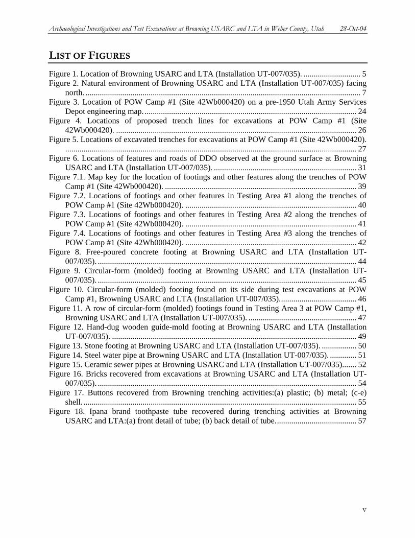
Archaeological Investigations and Test Excavations at Browning USARC and LTA in Weber County, Utah 28-Oct-04
LIST OF FIGURES
Figure 1. Location of Browning USARC and LTA (Installation UT-007/035). ............................ 5 Figure 2. Natural environment of Browning USARC and LTA (Installation UT-007/035) facing
north. ....................................................................................................................................... 7 Figure 3. Location of POW Camp #1 (Site 42Wb000420) on a pre-1950 Utah Army Services
Depot engineering map. ........................................................................................................ 24 Figure 4. Locations of proposed trench lines for excavations at POW Camp #1 (Site
42Wb000420). ...................................................................................................................... 26 Figure 5. Locations of excavated trenches for excavations at POW Camp #1 (Site 42Wb000420).
............................................................................................................................................... 27 Figure 6. Locations of features and roads of DDO observed at the ground surface at Browning
USARC and LTA (Installation UT-007/035). ...................................................................... 31 Figure 7.1. Map key for the location of footings and other features along the trenches of POW
Camp #1 (Site 42Wb000420). .............................................................................................. 39 Figure 7.2. Locations of footings and other features in Testing Area #1 along the trenches of
POW Camp #1 (Site 42Wb000420). .................................................................................... 40 Figure 7.3. Locations of footings and other features in Testing Area #2 along the trenches of
POW Camp #1 (Site 42Wb000420). .................................................................................... 41 Figure 7.4. Locations of footings and other features in Testing Area #3 along the trenches of
POW Camp #1 (Site 42Wb000420). .................................................................................... 42 Figure 8. Free-poured concrete footing at Browning USARC and LTA (Installation UT-
007/035). ............................................................................................................................... 44 Figure 9. Circular-form (molded) footing at Browning USARC and LTA (Installation UT-
007/035). ............................................................................................................................... 45 Figure 10. Circular-form (molded) footing found on its side during test excavations at POW
Camp #1, Browning USARC and LTA (Installation UT-007/035)...................................... 46 Figure 11. A row of circular-form (molded) footings found in Testing Area 3 at POW Camp #1,
Browning USARC and LTA (Installation UT-007/035). ..................................................... 47 Figure 12. Hand-dug wooden guide-mold footing at Browning USARC and LTA (Installation
UT-007/035). ........................................................................................................................ 49 Figure 13. Stone footing at Browning USARC and LTA (Installation UT-007/035). ................. 50 Figure 14. Steel water pipe at Browning USARC and LTA (Installation UT-007/035). ............. 51 Figure 15. Ceramic sewer pipes at Browning USARC and LTA (Installation UT-007/035)....... 52 Figure 16. Bricks recovered from excavations at Browning USARC and LTA (Installation UT-
007/035). ............................................................................................................................... 54 Figure 17. Buttons recovered from Browning trenching activities:(a) plastic; (b) metal; (c-e)
shell. ...................................................................................................................................... 55 Figure 18. Ipana brand toothpaste tube recovered during trenching activities at Browning
USARC and LTA:(a) front detail of tube; (b) back detail of tube........................................ 57
v

Archaeological Investigations and Test Excavations at Browning USARC and LTA in Weber County, Utah 28-Oct-04
LIST OF TABLES
Table 1. Specific Location of the Installation UT-007/035 – Browning USARC/LTA................. 4 Table 2. Prisoner-of-War Camps within the Continental United States....................................... 13 Table 3. Previous Projects and Known Cultural Resources in and within One Mile of the
Browning USARC and LTA................................................................................................. 21 Table 4. Features Identified During the Test Excavations at Installation UT-007/035 – Browning
USARC and LTA.................................................................................................................. 35 Table 5. Footing Features Identified During the Test Excavations at Installation UT-007/035 –
Browning USARC and LTA................................................................................................. 36 Table 6. Steel Water Pipe Features Identified During the Test Excavations at Installation UT-
007/035 – Browning USARC and LTA................................................................................ 51 Table 7. Features Identified During the Test Excavations at Installation UT-007/035 – Browning
USARC and LTA.................................................................................................................. 53 Table 8. Features Identified During the Test Excavations at Installation UT-007/035 – Browning
USARC and LTA.................................................................................................................. 53 Table 9. Table of Buttons Recovered from Trenching Activities at Browning USARC. ............ 56 Table 10. Description of Ipana Brand Toothpaste Tube Recovered from Trenching Activities at
Fort Douglas USARC. .......................................................................................................... 57
vi
Archaeological Investigations and Test Excavations at Browning USARC and LTA in Weber County, Utah 28-Oct-04
INTRODUCTION
In November 2003, the United States Army Reserve (USAR), 96th Regional Readiness Command (RRC) requested that SWCA, Inc. Environmental Consultants (SWCA) conduct cultural resources inventories of US Army Reserve facilities located within the command’s Area of Operations. The purpose of these inventories is to maintain the 96th RRC's compliance with Sections 106, 110, and 111 of the National Historic Preservation of 1966 (NHPA). This involves the identification, evaluation, and nomination of all historic properties within the Montana, Utah, Colorado, North Dakota, and South Dakota Area of Operations. In September 2004, following the initiation of the aforementioned inventories, the 96th RRC proposed construction of a new USARC within the Browning installation boundary. The 96th RRC requested that SWCA finalize cultural resource evaluations at the Browning USARC and LTA in order to address any issues required for compliance with Section 106 of the NHPA that could arise from the development of a new USARC. The Browning USARC and LTA consist of a block survey area, encompassing approximately 153 acres (61.92 hectares). SWCA carried out a pedestrian inventory within the boundary of the USARC and LTA. Two archaeologists conducted a Class III cultural resources inventory of Browning USARC and LTA using 15 meter (50 foot) transect intervals. Because the project falls under the jurisdiction of the USAR 96th RRC, the command’s environmental office is acting as the lead agency on this project. In order to maintain compliance with Section 106 of the NHPA, the lead agency will consult the Utah State Historic Preservation Office in order to request concurrence with its determination with regard to the proposed undertaking.
SWCA completed a pedestrian inventory of the project area between 01 and 02 June 2004. Test excavations were conducted between 28 September and 01 October 2004. Prior to field work a search of the project, site, and preservation files of the Utah Division of State History and the 96th RRC was undertaken. Historical maps from the State Engineering Office were delivered to SWCA from a contractor of the USAR 96th RRC. The file searches and field work were conducted by SWCA. All cultural resource work for the project was carried out under authority of the Utah State Antiquities Permit No. U-04-ST and Utah State Antiquities Project No. U-04-ST-1262m.
The purpose of SWCA's involvement in the project was to conduct cultural resource investigations. The intent of these investigations was three-fold. The first step was to identify any known and documented cultural resources in or immediately adjacent to Browning USARC and LTA. The second step was to carry out a pedestrian inventory of Browning USARC and LTA to determine if any undocumented cultural resources would be impacted by current operations conducted at the LTA or by future or proposed construction or maintenance at the USARC or the LTA. At the present time, the 96th RRC uses the Browning USARC and adjacent LTA as an engineering training area. Military engineers conduct earth-moving maneuvers on-site using a variety of heavy equipment. Therefore, the continued use of Browning USARC and LTA as an engineering LTA has resulted in the need to consider archaeological resources that may be present at or below the ground surface. The third intent was to assess if any actions undertaken
2

Archaeological Investigations and Test Excavations at Browning USARC and LTA in Weber County, Utah 28-Oct-04
by the 96th RRC at Browning USARC and LTA would affect the eligibility of archaeological resources within one mile of the Browning USARC and LTA.
3
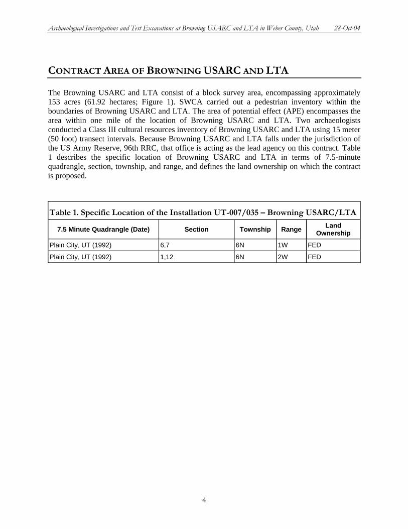
Archaeological Investigations and Test Excavations at Browning USARC and LTA in Weber County, Utah 28-Oct-04
CONTRACT AREA OF BROWNING USARC AND LTA
The Browning USARC and LTA consist of a block survey area, encompassing approximately 153 acres (61.92 hectares; Figure 1). SWCA carried out a pedestrian inventory within the boundaries of Browning USARC and LTA. The area of potential effect (APE) encompasses the area within one mile of the location of Browning USARC and LTA. Two archaeologists conducted a Class III cultural resources inventory of Browning USARC and LTA using 15 meter (50 foot) transect intervals. Because Browning USARC and LTA falls under the jurisdiction of the US Army Reserve, 96th RRC, that office is acting as the lead agency on this contract. Table 1 describes the specific location of Browning USARC and LTA in terms of 7.5-minute quadrangle, section, township, and range, and defines the land ownership on which the contract is proposed.
Table 1. Specific Location of the Installation UT-007/035 – Browning USARC/LTA
7.5 Minute Quadrangle (Date) Section Township Range Land Ownership
Plain City, UT (1992) 6,7 6N 1W FED
Plain City, UT (1992) 1,12 6N 2W FED
4

Archaeological Investigations and Test Excavations at Browning USARC and LTA in Weber County, Utah 28-Oct-04
Figure 1. Location of Browning USARC and LTA (Installation UT-007/035).
5
Archaeological Investigations and Test Excavations at Browning USARC and LTA in Weber County, Utah 28-Oct-04
ENVIRONMENT
Much of western and northern Utah falls within the Basin and Range physiographic province, a vast province extending north to central Idaho and Oregon and south to west Texas and Mexico. Short mountain ranges bounded by normal faults and surrounded by alluvium-filled valleys are numerous within the valley (Stokes 1986:251). The province is subdivided into thirteen sections; including the Wasatch Front Valleys subdivision (Stokes 1986).
GEOLOGY
The Wasatch Front Valleys were created from a combination of two geologic events:the receding of glacial moraines and water levels associated with ancient Lake Bonneville, and more recent deposition of sediment westward from the Wasatch Range into the Great Basin. The valleys are characterized as flat, low-lying, with a north-south trend (Stokes 1986:252-253). The valley furthest south is the Utah Valley, which includes Utah Lake. The valley furthest north is the Malad River Valley, which continues into Idaho. To the east the valleys are bounded by the Wasatch Front Mountains, while to the west the boundary is marked by the Great Salt Lake and a series of foothill mountains extending north and south of the lake (Stokes 1986:252-253).
Seismic activity along the fault lines within the region is high, with several of the most prominent fault lines in Utah. The most active zone of greatest vertical displacement in the state is the Wasatch fault. This fault follows the western edge of the Wasatch Mountains and runs north to south from Soda Springs, Idaho to Nephi, Utah, for a total of 210 miles. The fault is responsible for the dramatic uplift of the western face of the Wasatch Range from the valley floor (Stokes 1986:11-26, 242-243).
SOILS
The sediments in the Wasatch Front Valleys are classified as Mollisols, Aridisols, or Alfisols. The majority of surface soils in the Wasatch Front Valleys are Mollisols. Mollisols are a "thick, dark, relatively fertile surface soil, rich in humus" and tend to occur where average annual precipitation exceeds 12 to 14 inches and elevations are mainly above 5,000 feet (Wahlquist 1981:29). This soil type is usually formed under grassland or prairie conditions (James McMillan, personal communication 2000). Aridisols occur in areas of little annual precipitation (less than 12-14 inches), such a sagebrush, saltbush and similar desert-like communities. Entisols are young soils, lacking discernable horizons, but displaying some surface darkening (James McMillan, personal communication 2000). Alfisols are lighter-colored soils, usually formed in forested areas, displaying strongly alkaline horizons as a result from the influence of the water table and sodium (James McMillan, personal communication 2000).
FLORA
Within the Wasatch Front Valleys the sagebrush community is the dominant flora community, with small communities of shadscale. Small wetland communities can be found along the along
6
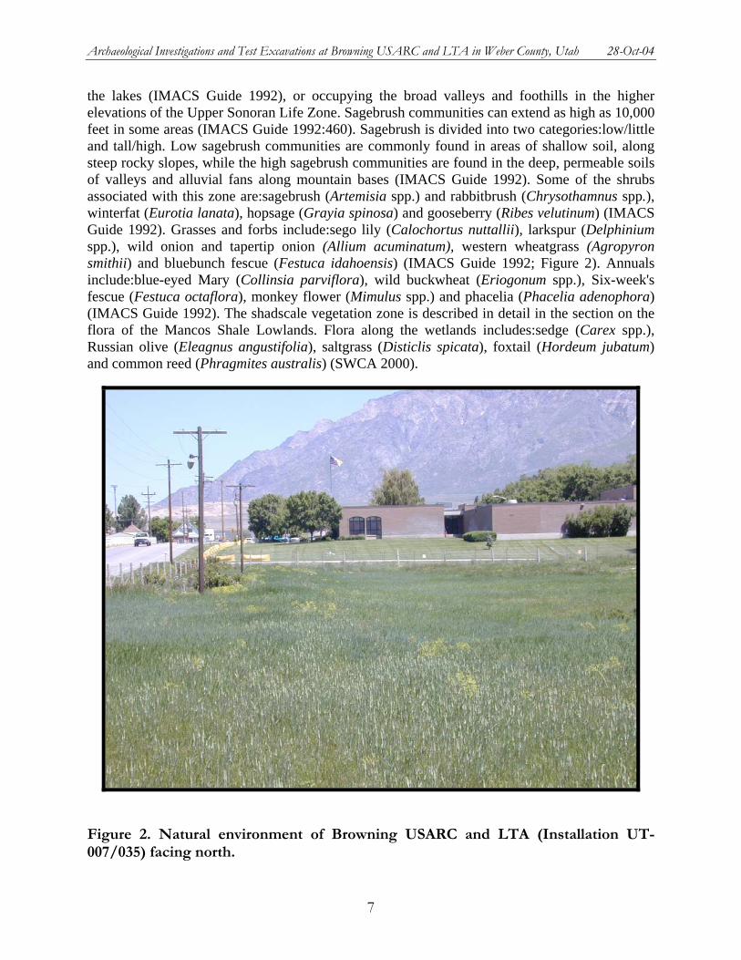
Archaeological Investigations and Test Excavations at Browning USARC and LTA in Weber County, Utah 28-Oct-04
the lakes (IMACS Guide 1992), or occupying the broad valleys and foothills in the higher elevations of the Upper Sonoran Life Zone. Sagebrush communities can extend as high as 10,000 feet in some areas (IMACS Guide 1992:460). Sagebrush is divided into two categories:low/little and tall/high. Low sagebrush communities are commonly found in areas of shallow soil, along steep rocky slopes, while the high sagebrush communities are found in the deep, permeable soils of valleys and alluvial fans along mountain bases (IMACS Guide 1992). Some of the shrubs associated with this zone are:sagebrush (Artemisia spp.) and rabbitbrush (Chrysothamnus spp.), winterfat (Eurotia lanata), hopsage (Grayia spinosa) and gooseberry (Ribes velutinum) (IMACS Guide 1992). Grasses and forbs include:sego lily (Calochortus nuttallii), larkspur (Delphinium spp.), wild onion and tapertip onion (Allium acuminatum), western wheatgrass (Agropyron smithii) and bluebunch fescue (Festuca idahoensis) (IMACS Guide 1992; Figure 2). Annuals include:blue-eyed Mary (Collinsia parviflora), wild buckwheat (Eriogonum spp.), Six-week's fescue (Festuca octaflora), monkey flower (Mimulus spp.) and phacelia (Phacelia adenophora) (IMACS Guide 1992). The shadscale vegetation zone is described in detail in the section on the flora of the Mancos Shale Lowlands. Flora along the wetlands includes:sedge (Carex spp.), Russian olive (Eleagnus angustifolia), saltgrass (Disticlis spicata), foxtail (Hordeum jubatum) and common reed (Phragmites australis) (SWCA 2000).
Figure 2. Natural environment of Browning USARC and LTA (Installation UT-007/035) facing north.
7
Archaeological Investigations and Test Excavations at Browning USARC and LTA in Weber County, Utah 28-Oct-04
FAUNA
Nearly all of western Utah falls into the Great Basin Faunal Area, including the Wasatch Front Valleys. Species requiring a moderate climate thrive in the area, as do species which are frequently found along the edges of desert and forest climates. Furthermore, with the large number of valley lakes and streams a large community of marshland and water species can be found. Geographically, the Wasatch Front Valleys are the largest faunal areas in the state (Durrant 1952:488). The rich and diverse wildlife in the area includes a variety of mammals, reptiles, amphibians and birds. Additionally, the effects exerted by Pleistocene Lake Bonneville are recognizable by the extensive speciation of the area, with 42 subspecies of 16 species (Durrant 1952:488-489). A large variety of small mammals are found including:ground squirrels (Citellus spp.), chipmunks (Eutamias spp.), pocket gophers (Thomomys talpoides), pocket mice (Perognathus spp.), kangaroo rats (Dipodomys spp.), and numerous species mice (family Cricetidae) (Durrant 1952). Middle to large sized mammals common throughout the area are:coyote (Canis latrans), badger (Taxidea taxus), skunk (Mephitis mephitis), mule deer (Odocoileus hemionus), mountain lion (Felis concolor), and bobcat (Lynx rufus). (Durrant 1952). The following species are found only in the Great Basin Faunal Area:pygmy rabbit( Sylvilagus idahoensis), Utah prairie dog (Cynomys parvidens), Townsend ground squirrel (Citellus townsendii), and Pennsylvanian meadow mouse (Microtus pennsylvanicus) (Durrant 1952). Common amphibians and reptiles are:frogs (Rana spp.), toads (Bufo spp.), lizards (Sceloporus spp.), and snakes, including racers (Coluber spp.) and Western rattlesnake (Crotalus vinidis) (Stebbins 1985). Birds are abundant, with songbirds, birds of prey and waterfowl accounting for some of the diversity. The Great Blue heron (Ardea herodias), Canada goose (Branta canadensis), numerous species of duck (Anas spp.), Swainson's hawk (Buteo swainsoni), and Western bluebird (Sialia mexicana) are but a few (National Geographic Society 1983).
CLIMATE
January temperatures in the province average between –9.0 and 2.2 degrees Celsius (36 and 16 degrees Fahrenheit), as opposed to the warm July temperatures that range between 13 and 33 degrees Celsius (56 and 92 degrees Fahrenheit). Between 120 and 160 frost free days are common throughout the area. Yearly precipitation averages between 30.5 and 40.4 centimeters (12.0 to 15.9 inches), arriving most frequently in the form of snow, as winter storms accumulate around the plateaus and rocky peaks.
8
Archaeological Investigations and Test Excavations at Browning USARC and LTA in Weber County, Utah 28-Oct-04
HISTORICAL OVERVIEW
By Jason Green
You're prisoners now. Obey all the rules and regulations. Some day if we're lucky, we will see our families and our homes again … —An Italian Colonel in the Tunisian Mountains upon his surrender to the British Army, January 1943 (Keefer p. 1).
Historical overviews are prepared to provide a chronological and thematic provenance for archaeological sites and historical properties. Given that only archaeological remains of historical archeological properties were observed during the Browning USARC and LTA portion of the 96th RRC Project, only that context is presented here. Several excellent historical overviews to World War II and prisoners-of-war exist today. The works of Busco and Alder (1971), Cunningham (1976), Van Valkenburg (1995), Keefer (1992), Weber (1991), and Powell (1989) were used to compile this historical overview.
LAWS AND TREATIES
War has been a part of society since before the dawn of civilization, and subsequently the plight of prisoners of war has generally been one of the tragic tales of humankind. Philosophy from the Enlightenment brought about more congenial views on humanity, and with these, a more ethical view of how we should view war. The understanding that war is a relation of state-to-state and not person-to-person, promoted basic human rights for prisoners (Busco and Alder 1971:56). In 1863, the International Red Cross arose as a champion for human rights due to their care for the injured during the Crimean War (Busco and Alder 1971:56). A year later, at the 1864 International Red Cross convention in Geneva, a treaty concerning the treatment of prisoners of war was signed by participating countries (Busco and Alder 1971:56). The original treaty has been revised periodically. The adoption of new treaties extended Red Cross protection to victims of warfare at sea (1907), to prisoners of war (1929), and to civilians in the time of war (1949) (Busco and Alder 1971:56).
The general rules of the treatment of prisoners of war progressed with the Hague Conventions of 1899 and 1907, in which the United States participated and signed (Cunningham 1976:14). Unfortunately two minor participants did not sign the convention, rendering it legally inoperative (Cunningham 1976:14). However, those that did sign were morally obligated to adhere to the rules (Cunningham 1976:14).
"Forty-seven nations agreed agreed that prisoners of war should receive humane treatment, protection of their persons, adequate housing and food, intellectual and physical diversion, and the right to elect spokesmen" (Busco and Alder 1971:56). The agreement included to not employ prisoners of war in military work or in the production of war materials; however, prisoners were allowed to work in other capacities (Cunningham 1976:14). Officers who were captured and interned did not have to work and non-commissioned officers, while not required to work, where required to supervise their subordinates (Cunningham 1976:14). Geneva Conventions further
9
Archaeological Investigations and Test Excavations at Browning USARC and LTA in Weber County, Utah 28-Oct-04
stipulated that war prisoners be interned away from the danger of combat areas (Busco and Alder 1971:56).
INTERNATIONAL WAR
Prisoners of war were detained in the United States during both World War I and World War II. However, due to volume of prisoners and its impact on American soil and the American West, added detail will be paid to WWII.
THE GREAT WAR:WORLD WAR I (1914-1918)
The United States Congress ratified the Hague Convention of 1907 on November 27, 1909 (Cunningham 1976:15). While the outbreak of war occurred in 1914, the United States remained neutral until President Woodrow Wilson called on Congress to issue a declaration of war in April of 1917 (Cunningham 1976:15). It was the intention of the Wilson Administration to uphold the Convention because the U.S. desired to give Germany no justification for ill treatment of Americans taken prisoner (Cunningham 1976:15). It was with this philosophy that the United States entered World War I (Cunningham 1976:15).
Three internment camps in the United States, including Fort McPherson, Georgia, Fort Oglethorpe, Georgia, and Fort Douglas, Utah were primarily used during World War I. These included prisoners of war from German naval vessels seized in the beginning of the war in April, 1917 (Cunningham 1976:3). Fort Douglas, Utah, or War Prison Barracks Number 3, held approximately 509 sailors from vessels interned in the Pacific, including those from the German Auxiliary Cruiser, the S.M.S Cormoran (Cunningham 1976:6). 870 enemy aliens from various points in the West, and 200 conscientious objectors were also included (Cunningham 1976:6).
WORLD WAR II (1939-1946)
With Germany's invasion and conquest of Poland and France and England's declaration of war on Germany in September of 1939, the world was thrust into a war that would drag on for six years and claim the lives of 45 million people. However, the United States would not become directly involved until December 7, 1941, the day that would "live in infamy."
As War spread throughout the nations of Europe, navigation of the seas became increasingly dangerous. Hitler's invasion of Poland and Britain's subsequent declaration of war against Germany and its ally Italy, left many German and Italian seamen stranded in United States ports at the end of 1939 (Van Valkenburg 1995:5). For those nations that Great Britain was now at war with, the safe passage through international waters for any ships carrying able-bodied was not guaranteed(Van Valkenburg 1995:5).
On the last weekend in March, President Roosevelt, ordered 69 German, Italian and Danish vessels seized using the authority of the 1917 espionage act that made it a crime to damage a ship, whether foreign or domestic, harbored in territorial waters in the territorial waters of the United States (Van Valkenburg 1995:5). Taken into custody were 775 Italian seamen and 100 German sailors. The Danes were allowed to remain on board (Van Valkenburg 1995:5). These were the first of thousands of international prisoners interned on U.S. soil.
10

Archaeological Investigations and Test Excavations at Browning USARC and LTA in Weber County, Utah 28-Oct-04
There were two official reasons for transfer of prisoners of war to the U.S. The first was to take pressure off of the soldiers taking care of the prisoners while engaged in an active theater, and the second was to help alleviate the man power shortage in the U.S (Busco and Alder 1971:56). There was also little extra costs in transporting the prisoners to the United States because most of the returning ships would otherwise be empty (Weber 1991:viii). The American continent offered the advantage of remoteness where captured enemy soldiers could be easily guarded with minimal effort (Busco and Alder 1971:56).
"Some argued that American Ships loaded with German prisoners of war would be less likely targets for German submarines, and in fact, during the course of the war, no transport ships with prisoners of war on board were sunk. Others felt that if German prisoners could see the United States and experience at least some of the benefits of democracy, they would jettison whatever Nazi or communist sympathies they had and return home committed to make democracy work." (Weber 1991:ix).
Ultimately, the United States would care for approximately 175,000 German prisoners, and approximately 51,000 Italian soldiers captured by the British.
The first large scale campaign by the United States that first brought the question of enemy prisoners of war was the Anglo-American offensive in North Africa. Of the thousands of German soldiers that were captured during 1942 and 1943, most were sent to camps in every state except Vermont and Nevada (Powell 1989:41). "During May 1943, 20,000 German prisoners of war were sent to the United States; and by the end of 1943, there were 123,440 German prisoners in the Country. A year later, there were 306,581; and by the end of the war with Germany in 1945, there were 371,683. In comparison, approximately 95,000 Americans were captured by the Germans and held in prisoner camps located throughout Germany and Austria" (Powell 1989:41).
The majority of the prisoners interned in the United States were in fact, German and Italian. However, it must be pointed out that prisoners from several countries including France, Luxembourg, Belgium, the Netherlands, Austria, Czechoslovakia, Yugoslavia, Rumania, Poland, Lithuania and Russia were also a part of the POW population.
"By 1946, approximately 371,000 Germans, and 51,000 Italians were held as prisoners of war in the United States. German prisoners were sent to the United States in three general groups. The first were those captured during the fighting in North Africa in late 1942 and 1943. By the end of 1943 there were 123,440 German prisoners of war in the United States. The second group numbered about 50,000 men, most of whom were captured in during the fighting in Italy. The third group, which numbered 182,000, was captured after the June 6, 1944 landing at Normandy and up to the German Capitulation" (Weber 1991:ix). Virtually all of the approximately 51,000 Italian soldiers, sailors, and airmen held in the United States were taken prisoner in North Africa or Sicily (Keefer 1992:1).
The U.S. kept far more Italians prisoners of war in the war zone than it brought to America. As of September 1943, it held about 82,000 in North Africa and Sicily (Keefer 1992:28). Approximately 28,000 of those retained in North Africa eventually were used in support of the
11
Archaeological Investigations and Test Excavations at Browning USARC and LTA in Weber County, Utah 28-Oct-04
U.S. troops invading southern France in October 1944 (Keefer 1992:28). The French authority received roughly 15,000 Italian troops to help with their rebuilding efforts (Keefer 1992:28).
German and Italian prisoners who went to the United States entered the country at Boston, New York City, and Norfolk, Virginia (Powell 1989:5). This process was surprisingly fast and efficient. The following exert captures the excitement and the fear that a prisoner of war would have felt as he arrived in the United States for the first time.
A radiant blue heaven covers the metropolis of New York City like a giant canopy. In the upper bay of the Hudson River the Thomas Marshall docks as the German prisoners of war assemble on deck to disembark. Greeted by the small island with the Statue of liberty, it works magic as smiles break across the faces of foreign soldiers-soldiers who despite all efforts are conscious that we are prisoners of the freest land under the sun. But our hearts beat in unhappiness, despite the impressive display that comes from all sides. Our amazed focus is on the mighty monuments of stone. The skyscrapers of Manhattan, weathered gray, cold, and foreign, completely impersonal, towering in the American sky. Then in deep shame we glimpse at our worn uniforms whose color can no longer be distinguished. Even when everyone had done their very best with what was available not to frighten the unknowing citizens of this war-spared land, our clothing is nothing more than rags. Our appearance depresses everyone at the moment.—Helmet Horner, German prisoner of war (Weber 1991:261)
Another German prisoner described his amazement on arriving at Norfolk at night:
The warf, the city, everything is brilliantly lighted. Hundreds of lights are reflected in the water. These people here have no idea what war means. Back home they may be sitting again in air raid shelters (Powell 1991:51).
After the war had ended prisoners were shipped back to their respective countries to be repatriated and participate in the rebuilding process in Europe.
THE PRISONS AND PRISON LIFE
From New York, Boston and Norfolk, the prisoners were loaded onto trains and shipped to their respective destinations. The nearly one-half million German and Italian prisoners of war sent to the United States between 1943 and 1945 were scattered throughout forty-five of the forty-eight states in hundreds of base and work camps holding between a hundred and several thousand prisoners each (Weber 1991:viii). Although hundreds of base camps and dependent branches scattered throughout the country, the focus of this report is in POW camps in Utah, Montana, Colorado, South Dakota and North Dakota. The camps varied in size as well as the nationality of the prisoners that were held. Table 2 below shows a list of all base camps per state. Several smaller agricultural or other work-related camps were also located in each state.
12
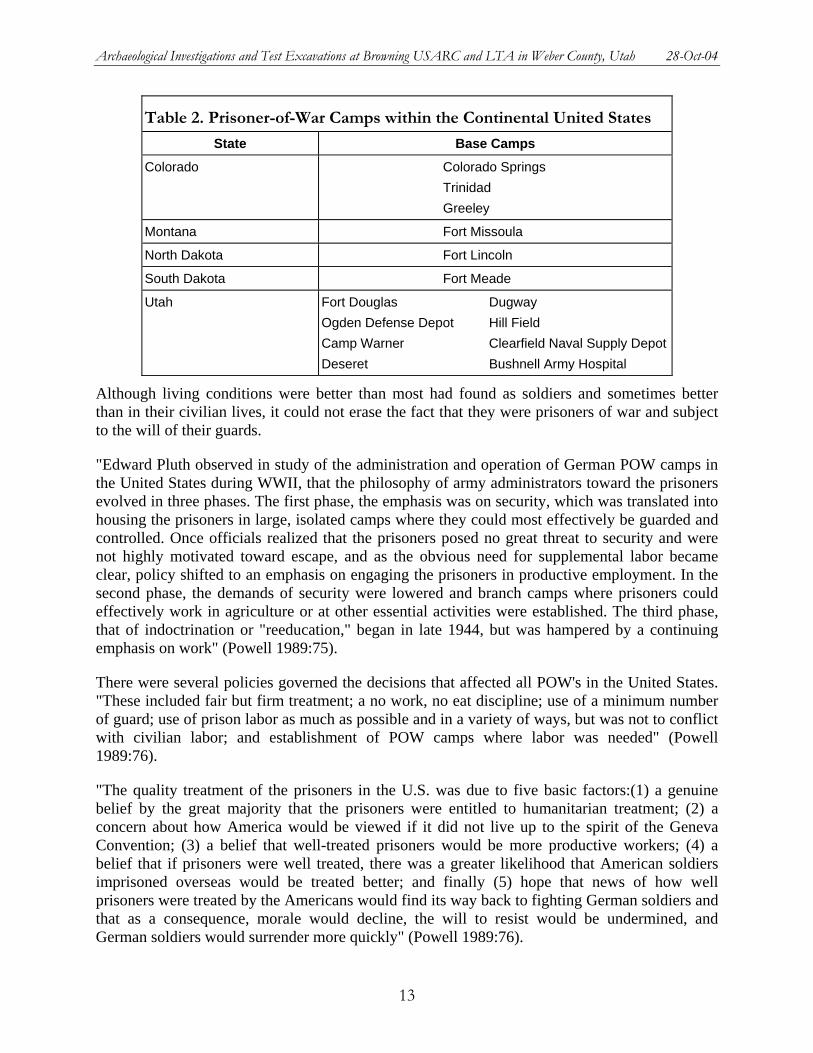
Archaeological Investigations and Test Excavations at Browning USARC and LTA in Weber County, Utah 28-Oct-04
Table 2. Prisoner-of-War Camps within the Continental United States
State Base Camps
Colorado Colorado Springs Trinidad Greeley
Montana Fort Missoula
North Dakota Fort Lincoln
South Dakota Fort Meade
Utah Fort Douglas Dugway Ogden Defense Depot Hill Field Camp Warner Clearfield Naval Supply DepotDeseret Bushnell Army Hospital
Although living conditions were better than most had found as soldiers and sometimes better than in their civilian lives, it could not erase the fact that they were prisoners of war and subject to the will of their guards.
"Edward Pluth observed in study of the administration and operation of German POW camps in the United States during WWII, that the philosophy of army administrators toward the prisoners evolved in three phases. The first phase, the emphasis was on security, which was translated into housing the prisoners in large, isolated camps where they could most effectively be guarded and controlled. Once officials realized that the prisoners posed no great threat to security and were not highly motivated toward escape, and as the obvious need for supplemental labor became clear, policy shifted to an emphasis on engaging the prisoners in productive employment. In the second phase, the demands of security were lowered and branch camps where prisoners could effectively work in agriculture or at other essential activities were established. The third phase, that of indoctrination or "reeducation," began in late 1944, but was hampered by a continuing emphasis on work" (Powell 1989:75).
There were several policies governed the decisions that affected all POW's in the United States. "These included fair but firm treatment; a no work, no eat discipline; use of a minimum number of guard; use of prison labor as much as possible and in a variety of ways, but was not to conflict with civilian labor; and establishment of POW camps where labor was needed" (Powell 1989:76).
"The quality treatment of the prisoners in the U.S. was due to five basic factors:(1) a genuine belief by the great majority that the prisoners were entitled to humanitarian treatment; (2) a concern about how America would be viewed if it did not live up to the spirit of the Geneva Convention; (3) a belief that well-treated prisoners would be more productive workers; (4) a belief that if prisoners were well treated, there was a greater likelihood that American soldiers imprisoned overseas would be treated better; and finally (5) hope that news of how well prisoners were treated by the Americans would find its way back to fighting German soldiers and that as a consequence, morale would decline, the will to resist would be undermined, and German soldiers would surrender more quickly" (Powell 1989:76).
13
Archaeological Investigations and Test Excavations at Browning USARC and LTA in Weber County, Utah 28-Oct-04
With these principles in mind, camp leaders and guards had an important role to fill. Not only were they there to watch over the POW's and keep the peace, but they were there to foster positive relations, and leave a formative impression of the United States and democracy. However, throughout the first years, the quality of the officers and guards assigned to these camps were often criticized. Some complained that camp administrators were selected in a haphazard fashion with no consideration as to how well they would relate to the prisoners. Officers were assigned to camps as punishment, and it was generally believed that less qualified officers were given stateside duty rather than being stationed overseas (Powell 1989:77). May guard units were composed of personnel who had some disability that disqualified them from combat duty.
…[T]he quality and caliber of the guards [w]as very poor. They were of low mentality, non-intellectual, and could neither understand nor see the reason for the Geneva Convention. Many drank and went AWOL. They read comic books rather than listening to the news. They liked to think of themselves as heroes, their one desire to shoot a kraut. —An American soldier assigned to a Utah prison camp (Powell 1989:77)
Beginning in 1945, guards received screening for potential mental problems, and every effort was made to use returning veterans to replace the current and less qualified guards (Powell 1989:77). Former prisoners recalled that their guards were almost always fair-minded, usually friendly, and seldom hostile or antagonistic (Powell 1989:77). Guards and other personnel were told that they were:
an advertisement for democracy and whether an individual is a good advertisement or a bad one depends on the attitudes he had toward his duties and toward the prisoner, use of weapons in handling the prisoners, military bearing; neatness; alertness; the importance of adhering strictly to the Geneva Convention; and the importance of their job in relation to the overall United States military effort. (Powell 1989:80)
FACILITIES
Responsibility for the location of the POW camps was given to the respective service commands (Powell 1989:54). Fort Douglas was the headquarters for the Ninth Service Command, administering camps in Washington, Utah, Oregon, Idaho, California, Arizona and Montana (Powell 1989:54).
Security was the primary factor in deciding on where to locate the camps (Powell 1989:54). Camps were recommended to be further than 75 miles from the coasts, the Canadian and Mexican borders, as well as shipyards, aircraft plants, or other war installations (Powell 1989:54). Climate, construction maintenance were given consideration after security concerns were addressed. With this in mind, most camps were located in the southern, midwestern, and southwestern states (Powell 1989:54). As the war moved on, priority was placed on labor instead of security. Camps began to be disbursed more evenly throughout the country to address the increasing labor shortages. However, the camps generally consisted of nine to ten-foot high barbed wire fences, sometimes two to three layers deep, and armed, elevated guard towers with
14
Archaeological Investigations and Test Excavations at Browning USARC and LTA in Weber County, Utah 28-Oct-04
searchlights, were generally located at each of the four corners of the compound. Smaller branch camps, such as Salina in Utah, would only have one or two guard towers (Powell 1989:58).
The size, architecture and appearance of the base camps in the United States were varied throughout the country. Federal government camps formerly belonging to the Civilian Conservation Corps, the National Youth Administration, the Farm Security Administration and other governmental agencies including state and local fairground buildings, armories, schools, and auditoriums that were adapted to provide for prisoners. The two largest camps whose facilities are now operated under the 96th RRC are the Ogden Defense Depot and Fort Missoula.
The Ogden Defense Depot, was known during the war as the Utah Army Services Depot or the Utah General Depot. The POW compound occupied a space of approximately 1,175 by 1,275 feet, with a 500 by 1,000 foot recreation area (Powell 1989:58). At its peak in September of 1945, the camp housed almost 4,000 German POW's (Powell 1989:65). The camp can be said to have followed the typical army plan. The buildings inside the compound were covered with tarpaper and insulated on the inside. The buildings included 45 barracks, eight mess halls, eight latrines, one canteen a recreation hall two infirmaries a chapel, a theater, a carpenter shop, and a building for day rooms (Powell 1989:58). The prisoners were assigned to companies of 250 men (250 to 300 men was common at most camps), and each company occupied five barracks with 50 men assigned to each barrack (Powell 1989:58). There was also one washroom for each barrack. The buildings were single story wooden buildings heated by coal burning stoves (Powell 1989:58).
Fort Missoula was under the control of the Immigration and Naturalization Service after the Army's Fourth Infantry was transferred to Alaska in 1940 (Van Valkenburg 1995). There were several existing buildings already on the compound, but most had to be adapted to meet the needs of the incoming Italian POW's (Van Valkenburg 1995). The camp contained barracks that housed the nearly 1,000 POW's, with each barrack housing 40 to 60 men and a minimum of 40 square feet of floor space for each man. The compound also included a headquarters/administration building, a hospital, a large recreation area, a canteen, mess halls, and warehouses for storage equipment, supplies, food and baggage of the detainees (Van Valkenburg 1995:9).
FOOD
Two criteria were commonly used to measure how well prisoners of war were being treated. The extent of their mental and physical health, and the quality and quantity of food sustenance provided (Powell 1989:82). The quality of food served to the POW's in the U.S. was known to be very good. Efforts were made to provide food that better reflected the national diet they were used to, as opposed to the standard American fare (Powell 1989:82).
At Fort Missoula, the food by most accounts was good, though at first, several Italians complained about the reliance on canned foods, which they considered poisonous (Van Valkenburg 1995:23). A daughter of a local grocery store owner recalls, "they got sugar, they got oil, they got anything they wanted, my dad would get a permit and would try and get and they got it" (Van Valkenburg 1995:23). Many agreed that the men ate better than most of the
15
Archaeological Investigations and Test Excavations at Browning USARC and LTA in Weber County, Utah 28-Oct-04
Missoulians at that time. Lyle Slade, a Border patrolman, said the Italians were fed round steak at a time he was unable to get even hamburger (Van Valkenburg 1995:24).
American officials carefully observed the German eating habits and cooking practices. Their findings and recommendations were even published as the Prisoner of War Menu and Messing Guide (Powell 1989:82). The most popular item by far was the potato, and it was estimated that a prisoner would consume about a pound of potatoes with a meal (Powell 1989:82). The commander of one of the POW companies at Ogden recalled that they had to get permission from the International Red Cross to double the potato ration and cut the meat ration in half as requested by the prisoners (Powell 1989:82). Fresh fruits and vegetables were served as opposed to the frozen style because "prisoners are not used to this type of food and spoilage and waste will result" (Powell 1989:83).
The only complaints about the food came towards the end of the war, during the summer of 1945. Interpretation of Article 11 of the Geneva Convention changed from food provided to POW's was to be the same quality and quantity as that provided to soldiers, to the same quantity and quality of nutrients. This meant that high quality meats were downgraded to less desirable cuts (stomach, etc.) among other things, and a cut back in the amount of food given. This brought a substantial change in the quality of food, as well at the quality of work the prisoners were doing (prisoners had opportunities to work, and will be discussed further). One Colorado farmer complained the prisoners sent to his farm were only given two hard-boiled eggs for their lunch and Idaho farmers complained that the prisoners were not being fed enough to complete a full day's work (Powell 1989:84). At Ogden, to make a statement, some prisoners elected live on a diet of bread and water rather than continue to work when food restrictions were in place, and at Salina, Utah, prisoners caught fish in the ditches and canals to supplement their evening meals (Powell 1989:84). There were however, up to this point, relatively few complaints.
Article 12 of the Geneva Convention called for the establishment in all camps of a shop or room in which the prisoners could purchase food and necessities at prices comparable to those for civilians in surrounding areas (Powell 1989:86). Compound canteens were therefore set up to meet these requirements. Most, but not all camps sold beer and cigarettes as well. The Italians at Fort Missoula did not quite get all of there necessities. Alcohol was a ban that the Italians fought, and worked hard to overcome. "We used to make our own but no alcohol was allowed. Dried raisin, dried prune, dry apricots, dry anything – dry figs. We used to get all these dry food for desert, but we used to save them" (Van Valkenburg 1995:26).
Cigarettes were a popular commodity in the camps. Unfortunately, at the same time that restrictions were placed on the amount of food prisoners received, the supply of American cigarettes was also scaled back (Powell 1989:86). In some camps, no tobacco was available at all; while, in others, the men had to be content with rolling their own cigarettes from tobacco available in small sacks of Bull Durham, call "Arizona Dust" by the Ogden prisoners (Powell 1989:86). In May of 1945, strict orders were issued from Fort Douglas that beer, candy, cigarettes, cookies, crackers, and all soft drinks were to be removed from German POW canteens in the Ninth Service Command (Powell 1989:86). However, it may have been the removal of the 3.2 beer from the canteens that may have created the biggest stir. It wasn’t until after September of 1945 that the restrictions were finally lifted (Powell 1989:87).
16
Archaeological Investigations and Test Excavations at Browning USARC and LTA in Weber County, Utah 28-Oct-04
HEALTH CARE
According to the Geneva Convention, the host country was required to provide all of the necessary medical and hospital treatment. Therefore, the prisoners were required or were supposed to receive the same medical and surgical services given to American personnel.
In the smaller camps, those who unfortunately ended up in the infirmary were usually under the care of a medic who would render care to both American personnel and prisoners alike. Civilian doctors were also under contract to handle serious cases; and if it was deemed necessary, prisoners were transferred to main camps (Powell 1989:68). A 200 bed hospital built in Ogden, to initially care for Italian prisoners was used by the Germans in various ways (Powell 1989:68).
Although all major camps had medical facilities, those who fell seriously ill, or were seriously injured throughout the west, were flown to Bushnell Hospital south of Brigham City, UT (Powell 1989:68).
The frequency of transfers did create difficulties in following up with medical and dental care. Prisoners who had their teeth extracted may have to wait months before their new dental plates would arrive (Powell 1989:68). In Missoula, there were difficulties in finding physicians that were interested in contracting their services. The Chief Medical Officer at Fort Missoula stated that:
In the last six months we have had four different eye specialists. Eye examinations have been a constant source of trouble for me, principally because the eye specialists are so busy with their own practices that they do not seem to be interested in our work. In addition to this, the language incompatibility, neuroses and unreasonable requests makes it possible for me to understand their lack of interests in our work. (Van Valkenburg 1995:23)
Boredom and isolation would begin to take a toll on the prisoners mental state as well. At Fort Missoula, as well as most camps, prisoner officials tried to provide as many outlets as possible. “In a report to the Immigration Service, the camp medical officer noted that in one month there were 1,404 sick calls recorded form among only 1,272 men. This is directly attributed to the fact that some of these men have been away from their homes and families for three or four years, incarcerated in prisons and detained in camps" (Van Valkenburg 1995:32).
RECREATION
Umberto Benedetti remembers life at Fort Missoula fondly. A typical day, he recalls, consisted of tennis, soccer, swimming, dancing or listening to music or opera. "[T]he life was just like an ordinary life, just like now," he said (Van Valkenburg 1995:18).
Shortly after the Ogden camp was established, the library possessed approximately 400 titles consisting of German novels, history books, textbooks, religious works, classics, poetry collections and a few English books (Powell 1989:179). The library increased its size to approximately 2500 volumes in less than a year later (Powell 1989:179). By May 1945, the library was a large success with 75 percent of the books in constant circulation and 60 percent of the prisoners used the library and reading room (Powell 1989:179).
17
Archaeological Investigations and Test Excavations at Browning USARC and LTA in Weber County, Utah 28-Oct-04
Access to radios and phonographs were also made available. The rationale in allowing radios in the camps was to let prisoners know that the U.S. are not dictators or slave drive drivers, but on the contrary, we are loving, caring and respecting people (Powell 1989:180).
Films were also shown as frequently as possible. At Ogden, it took eight days to show weekly movies to all of the prisoners (Powell 1989:180). The films shown were usually American for the most part with German subtitles, however some German films were also included (Powell 1989:180). A thirty-man theater group in Ogden was created to provide entertainment before films were made available (Powell 1989:179).
Music was vital part of all of the POW camps. At Fort Missoula, prisoners included Italian musicians from the World's Fair and the luxury cruise liner Conte Biancamano. Musical performances were a nightly event (Van Valkenburg 1995:18). A band could have been playing in one part of the camp with the audience singing along to Italian songs, while in other parts of the camp, an orchestra may be putting on a concert, while still in other parts of the barracks, violinists, pianists and other instruments could be heard (Van Valkenburg 1995:18). There were more than one hundred musicians detained at the fort (Van Valkenburg 1995:18).
In Missoula, the Italians began to hold regular concerts for the community, while charging a small admission fee (Van Valkenburg 1995:28). By voting to contribute ten percent of their proceeds to the Missoula Iron Lung Foundation, they engendered good will among the Missoula community (Van Valkenburg 1995:28). The Italians were becoming an appreciated part of the community. They also performed plays regularly, including several in which the men played both male and female parts (Van Valkenburg 1995:28).
Arts and crafts were also a popular pastime for the POWs. In Ogden, space was made available for everything from sketching to woodcarving (Powell 1989:184). Larger projects also included aquariums, animal cages, chapels, and even a smokehouse for sausage (Powell 1989:184). In Missoula, the creation of miniature ships and other models was popular. Their pieces were displayed everywhere. Nick Collaer, the POW supervisor at Fort Missoula was quoted as saying that is job was to:
keep up morale and provide clothing and entertainment. None seem to harbor ill feelings toward America. One detainee went so far as to say that he would crawl on his hands and knees to kiss the American flag if he could become an American citizen. (Van Valkenburg 1995:28)
EDUCATION
In an effort to educate POWs of the benefits of democracy and the American political system, the army undertook the task of politically educating the POWs; an attempt the propagandize the prisoners of war to the United States democratic system. It was an experiment in a "democratic leadership" for postwar Germany (Paschal 1979:134). There was however some debate over the effectiveness of this program. "Books that had been banned by Hitler's Nazi regime and books "representative of the American spirit" were distributed in the camps. Abe Lincoln in Illinois was one such book that was widely circulated" (Paschal 1979:134). Large numbers of books were even contributed by several universities to the camps, and opportunities for educational degrees
18
Archaeological Investigations and Test Excavations at Browning USARC and LTA in Weber County, Utah 28-Oct-04
were even made available through coordination of the Swiss and German governments (Paschal 1979:134).
Many prisoners turned to educational opportunities to pass the free time and to better themselves. “In Camp Warner a well-organized educational program utilized POW instructors with classes in mathematics, German, English, Latin, French, Spanish, shorthand, bookkeeping, chemistry, geometry, literature and writing. In May 1944, educational opportunities included fifteen different classes available to 600 German prisoners” (Powell 1989:186). In Clearfield, the camp spokesman felt a strong need to give his fellow prisoners "the opportunity for education so that someday they could carry on their work in the Germany of the future" (Powell 1989:187).
WORK
Prisoners of war became an essential element of the U.S. work force, due to the number of American men now fighting or preparing to fight overseas. The Geneva Convention provided that POWs, with the exception of officers, could be put to work as long as they were healthy. Noncommissioned officers could only be used to supervise other prisoners.
Prisoners of war were used in a variety of industries across the country, from working in warehouses, to working for a variety of state agencies. It was on the farms in the Great Basin where they were best known and utilized. Under a contract labor agreement, local farmers, after proving that no native labor was available, could negotiate to use prison camp labor (Alder and Busco 1971:64). Under the terms of the contract, farmers had to pay the minimum wage for labor received, but the money was paid to the government (Alder and Busco 1971:64). The prisoners received eighty cents a day, which they could spend as they wished. The remainder went to the government to meet housing and food expenses for the prisoners (Alder and Busco 1971:64).
In late 1942, the Ogden Depot was a leader in the utilization of prison labor (Powell 1989:158). Ogden was the first to use prisoners of war in technical service operations, when most Army officials were reluctant to use prisoners for such assignments because of a fear of sabotage Powell 1989:158). By late 1944, Italian Service Units aided the understrength arsenal staff by loading and unloading rail cars (USAF 1996:18). The following year, more than six hundred Italian personnel worked in the property division (USAF 1996:18). Gradually, other technical service depots throughout the United States followed Ogden's lead Powell 1989:158).
In Missoula, a large number of prisoners were courted by a variety of employers. Many were hired by the Forest Service, to work in a number of forests in the region (Van Valkenburg 1995:81). Many others helped on farms. The Italians were welcomed into the communities without hesitation. Their reception was ironic because all of them were citizens of a nation with which the U.S. was at war (Van Valkenburg 1995:81). In contrast, the only Japanese employed in Montana were American citizens, but they were frequently treated as if they were enemies (Van Valkenburg 1995:81).
PRISONER-OF-WAR REPATRIATION
The German surrender in May of 1945 brought with it hopes of POWs to return home. Word of American POWS being repatriated from Germany caused increased anxiety and homesickness
19
Archaeological Investigations and Test Excavations at Browning USARC and LTA in Weber County, Utah 28-Oct-04
among German POWs, but the return trip home was to be a long one for many of the 371,000 German soldiers still held in the United States.
Immediate repatriation of German POWs was not a possibility due to several issues: 1) the conditions in Europe, 2) the U.S. focus on the war with Japan, 3) the lack of transportation facilities, 4) the vast amount of processing needed to prepare the soldiers, and 5) the need for agricultural labor to help with the 1946 crops (Powell 1989:249). By the end of 1945, only 57,000 POWs left the United States, while the remaining 314,000 remained till July of 1946 (Powell 1989:249). German prisoners in Utah were among the last to leave the United States (Powell 1989:249).
However, for many of the German prisoners, this was not the end of their journey. Upon arrival in Europe, many were turned over to British or French officials to help in the reconstruction efforts (Powell 1989:249). There was also talk about turning over POWs to the Russians; this however never came to fruition. Ultimately, 123,136 German POWs returned to England and approximately 55,000 were sent to France (Powell 1989:249). Nearly 50 percent of the prisoners experienced this kind of delay (Powell 1989:249).
Once settled in Europe, many former POWs began to write Americans whom they befriended while detained in the U.S. Many were American farmers for whom they had worked. An estimated 5,000 German POWs returned to the United States as postwar refugees or immigrants (Powell 1989:253). Several returned to Utah, some of them because they had become, or became, members of the Church of Jesus Christ of Latter-day Saints (Powell 1989:253). Others returned because of friends they had made while interned (Powell 1989:253).
20
Archaeological Investigations and Test Excavations at Browning USARC and LTA in Weber County, Utah 28-Oct-04
PREVIOUS RESEARCH
Prior to conducting fieldwork at Browning USARC, SWCA conducted a Class I file search at the State Historic Preservation Office (SHPO), Utah Division of State History (UDSH), and the files of the 96th RRC. Copies of historical maps from the Utah State Engineering Office were provided to SWCA by a member of the 96th RRC. This review of existing documentation was conducted in order to identify any previously documented cultural resource sites that may be present within one mile of Browning USARC and LTA. A total of 13 previous projects have taken place within one mile of the Browning USARC and LTA (Table 3). No archaeological sites have been documented within Browning USARC and LTA.
Table 3. Previous Projects and Known Cultural Resources in and within One Mile of the Browning USARC and LTA
Project # Reference Sites within 1 mile
of Browning USARC and LTA
Sites within Browning USARC
and LTA U-78-UC-473 2700 North Survey, Ogden, Utah. None None U-80-WD-615 A Cultural Resources Survey of a Proposed
Animal Shelter on the Willard Canal, Slaterville Diversion Dam, Weber County, Utah.
42Wb6 None
U-81-AF-927 Cultural Resource Evaluation of a Proposed County Road in Weber County, Utah.
None None
U-87-CN-615 Class III Inventory of Proposed AT&T Fiberoptics Facilities in Utah.
None None
U-87-AW-878 A Prehistoric Cultural Resources Study, Predictive Model and Field Survey, Weber Basin Project.
None None
U-88-SJ-608 A Cultural Resources Survey of a Portion of Washington Boulevard, Ogden, Utah.
None None
U-89-SJ-104 A Cultural Resources Survey of a Proposed Road Between 12th and 21st Streets, Odgen, Utah.
None None
U-89-SJ-698 A Cultural Resources Survey of Nine Proposed Traffic Signal Locations in Ogden and Logan, Utah.
None None
U-91-SJ-107 A Cultural Resources Survey of a Weber County Safety Improvements Project, Pleasant View, Weber County, Utah.
None None
U-92-SJ-802 A Cultural Resources Survey of the Proposed 1100 West Corridor, Weber County, Utah.
None None
U-95-SJ-245 A Cultural Resources Inventory of the Proposed 2700 North Corridor Route, Weber County, Utah.
None None
21
Archaeological Investigations and Test Excavations at Browning USARC and LTA in Weber County, Utah 28-Oct-04
Table 3. Previous Projects and Known Cultural Resources in and within One Mile of the Browning USARC and LTA
Project # Reference Sites within 1 mile
of Browning USARC and LTA
Sites within Browning USARC
and LTA U-96-NR-131 Report on the Cultural Resources Inventory
Survey Completed for the Proposed WorldCom Seattle to Salt Lake City Fiber Optic Line Part 1:Utah.
None None
U-78-UC-473:The Utah State Historical Society conducted this survey in 1978 for the proposed widening of 2700 North in North Ogden, Utah (Madsen 1978). No cultural resources were identified as a result of this project.
U-80-WD-615:Water and Power Resources Service conducted this survey in 1980 of the proposed animal shelter located on the Willard Canal in Weber County, Utah (Water and Power Resources Service 1980). This project is located 0.9 miles from the current project area. One historic campsite, 42WB6 was observed as a result of this project, and is recommended not eligible to the NRHP.
U-81-AF-927:AERC Archaeological-Environmental Research Corporation conducted this survey in 1981 for a proposed county road in Weber County, Utah (Hauck 1981). This project is located 0.9 miles from Browning USARC and LTA. No new archaeological sites were observed as a result of this project.
U-87-CN-615:Centennial Archaeology, Inc. conducted this survey in 1987 for the proposed AT&T fiberoptic cable and associated facilities in Utah (Tucker 1987). This project is located 0.9 miles from Browning USARC and LTA. Though several archaeological sites were observed as a result of this survey, none are located within, or within one mile of, the property boundary of Browning USARC and LTA.
U-87-AW-878:American Archaeological Consultants, Inc. conducted this survey and developed a predictive model of site location in 1986 for the proposed development activities in the southern Weber Basin (Levy and Ebright 1987). A portion of this project is located 0.9 miles from Browning USARC and LTA. Although this project identified 9 new archaeological sites, none of these are located within, or within one mile of, Browning USARC and LTA.
U-88-SJ-608:Sagebrush Archaeological Consultants conducted this survey in 1989 to assess the significance of sidewalks, curbs, and other objects associated with these features along a portion of Washington Boulevard scheduled for widening (Polk 1989b). This survey area is located one mile from Browning USARC and LTA. None of the historic features observed during this survey were considered historically significant.
U-89-SJ-104:Sagebrush Archaeological Consultants conducted this survey in 1989 for a proposed county road extension in west Ogden (Polk 1989a). This project is located 0.9 miles from the current project area. No new archaeological sites were observed as a result of this project.
22
Archaeological Investigations and Test Excavations at Browning USARC and LTA in Weber County, Utah 28-Oct-04
U-89-SJ-698:Sagebrush Archaeological Consultants conducted this survey in 1989 to determine the potential impacts of the installation of nine traffic signals on nearby historic properties in Ogden and Logan, Utah (Polk 1989c). One of these locations is located 0.8 miles from Browning USARC and LTA. None of these locations were found to significantly impact adjacent historic properties.
U-91-SJ-107:Sagebrush Archaeological Consultants conducted this survey in 1991 for proposed safety improvements in Weber County, Utah (Polk 1991). No cultural resources were identified as a result of this project.
U-92-SJ-802:Sagebrush Archaeological Consultants conducted this survey in 1993 for the proposed 1100 West corridor (Polk 1993). A portion of this survey area is located 0.8 miles from Browning USARC and LTA. No new archaeological sites were observed as a result of this project.
U-95-SJ-245:Sagebrush Archaeological Consultants conducted this survey in 1995 for the proposed 2700 North corridor in Weber County, Utah (Johnson, Langley and Housely 1995). A total of 15 historic structures were observed during this survey, none of which are located within one mile of Browning USARC and LTA.
U-96-NR-131:Northwest Archaeological Associates, Inc. conducted this survey in 1996 for the WorldCom Seattle to Salt Lake City fiber optic line (Barlow et al. 1996). Though 2 new archaeological and historic sites were observed as a result of this project, neither of these is located within one mile of Browning USARC and LTA.
During the Class I file search of this installation at the USARC State Engineering Office in Salt Lake City, historical records dating to 1944 indicated that a World War II (WWII) era prisoner-of-war (POW) camp was once located on these premises (Figure 3). The POW camp occupied an area of approximately 56 acres (23 Ha) within the LTA. Additional POW camps were also identified on the 1944 maps outside of Browning USARC and LTA, but will not be addressed in this research.
Limited information is available on the POW camp and largely consists of a military map dating to 1944. It shows Prison Camp 1 as a roughly rectangular polygon that is approximately 1250 feet east/west and 2350 feet north/south. In the northern portion of the camp, it is assumed that administrative facilities, offices, and a hospital were once present. In the larger block south of this area is the prison camp. It consisted of four rows of buildings on the east and west sides of two north/south trending parallel roads. These buildings trended east/west and may have served as barracks. On the outer edge of each row of buildings are north/south trending buildings. These buildings may have served as cafeterias or administrative housing. To the south of the prison camp is an empty area with one building. This area may have served as a location for recreation or may have been administrative.
23

Archaeological Investigations and Test Excavations at Browning USARC and LTA in Weber County, Utah 28-Oct-04
Figure 3. Location of POW Camp #1 (Site 42Wb000420) on a pre-1950 Utah Army Services Depot engineering map.
24
Archaeological Investigations and Test Excavations at Browning USARC and LTA in Weber County, Utah 28-Oct-04
METHODS
The Browning USARC and LTA consist of a block survey area, encompassing a total of 153 acres (61.92 hectares; see Figure 1). SWCA carried out a pedestrian inventory within the property boundary of Browning USARC and LTA. Two archaeologists conducted a Class III cultural resources inventory of Browning USARC and LTA using 15 meter (50 foot) transect intervals.
At the present time, the 96th RRC uses the Browning USARC and LTA as an engineering training area. Military engineers conduct earth-moving maneuvers on-site using a variety of heavy equipment. The continued use of the Browning USARC and LTA as an engineering LTA may result in the need to consider archaeological resources should the POW camp be present below the ground surface.
Due to the possibility that undisturbed features of Prison Camp #1 (identified during the Class I file search) may be present below the modern ground surface, SWCA recommended that the Browning USARC and LTA be tested for subsurface cultural resources related to the former POW camp. The purpose of the testing was to establish a presence or absence of the POW camp, determine its integrity, and make a National Register of Historic Places (NRHP) recommendation based on the results of the presence/absence and integrity testing.
SWCA proposed to test the site using heavy equipment and record any evidence of the site. A summary of the results of those data are presented in this report and in the Browning USARC and LTA section of the Utah report produced for the 96th RRC.
Specifically, SWCA proposed to trench, using a backhoe, no more than seven single-line trenches no more than 6 feet deep (Figure 4). Trenches 1 and 2 we defined in the northern portion of the POW camp, though, following the positive excavation results of Trench 2, Trench 1 was not excavated (Figure 5). Trench 2 cut, perpendicularly, across the former location of the southern set of administrative buildings from west to east.
Trenches 3-6 cut diagonally across the former location of the four rows of buildings on the east and west sides of two north/south trending parallel roads. Two "X" figures were made. Trenches 3 and 4 crossed diagonally through the westernmost portion of the prison camp complex. Trenches 5 and 6 crossed diagonally through the easternmost portion of the prison camp complex.
Trench 7 cut, perpendicularly (east/west), across the former location of the southernmost building from the western "fence" line to the eastern "fence" line centered on the building.
If other features or cultural material were identified within the trench, an in-field analysis of the artifacts or features was conducted. All artifacts were returned to the trenches near their point of origin upon completion of the in-field analysis. No artifacts were collected for curation. Results of the analysis are presented in this report.
25

Archaeological Investigations and Test Excavations at Browning USARC and LTA in Weber County, Utah 28-Oct-04
Figure 4. Locations of proposed trench lines for excavations at POW Camp #1 (Site 42Wb000420).
26

Archaeological Investigations and Test Excavations at Browning USARC and LTA in Weber County, Utah 28-Oct-04
Figure 5. Locations of excavated trenches for excavations at POW Camp #1 (Site 42Wb000420).
27

Archaeological Investigations and Test Excavations at Browning USARC and LTA in Weber County, Utah 28-Oct-04
All trenches were backfilled following excavation. RRC and OSHA safety guidelines were followed regarding overnight open trenches. The ground surface was returned to the original topography prior to excavation.
28
Archaeological Investigations and Test Excavations at Browning USARC and LTA in Weber County, Utah 28-Oct-04
RESULTS OF ARCHAEOLOGICAL INVESTIGATIONS
A pedestrian archaeological inventory and test excavations were conducted at Browning USARC and LTA. A total of 2 archaeological sites were identified. The following sections describe the investigations and the present the results of the findings. Also included are the individual archaeological site NRHP recommendations. Archaeological site forms may be found in Appendix A.
PEDESTRIAN ARCHAEOLOGICAL INVENTORY
SWCA conducted an intensive level, Class III cultural resource inventory of United States Army Reserve (USAR) Facility Identification Number UT-007, Frank M. Browning United States Army Reserve Center (Browning USARC) and the adjacent Local Training Area (LTA), at the Defense Depot of Ogden (DDO), Weber County, Utah on 01 and 02 June 2004. The primary purpose of is to maintain the 96th RRC's compliance with Sections 106, 110, and 111 of the National Historic Preservation of 1966 (NHPA). This involves the identification, evaluation, and nomination of all historic properties within the 96th RRC's area of operation. No specific construction project is currently proposed.
To meet these needs, the cultural resource inventory was focused upon the identification, evaluation, and potential nomination of cultural resources greater than 50 years of age that may be present on land controlled under the authority of the 96th RRC. A further requirement of the USAR's compliance with existing regulations is to take into consideration potential impacts of USAR actions to Historic Properties (e.g., cultural resources eligible for listing to the National Register of Historic Places [NRHP) located outside 96th RRC control.
The area surveyed includes 153 acres (61.92 hectares) of property controlled under the authority of the 96th RRC for the operation of Browning USARC. SWCA Project Manager Jim Christensen and Field Director Alan Hutchinson conducted fieldwork for this intensive level, pedestrian inventory. This inventory utilized methodologies for the identification of cultural resource materials or features that are available for visual inspection. Two archaeological sites were identified during the Class I file search and Class III cultural resources inventory.
Browning USARC and the adjacent LTA are located in the extreme northwest corner of the historical DDO and, as such, this property has experienced multiple uses since World War II.
29
Archaeological Investigations and Test Excavations at Browning USARC and LTA in Weber County, Utah 28-Oct-04
RESULTS OF THE CLASS III CULTURAL RESOURCES INVENTORY
Browning USARC and its associated structures appear to have been constructed in the late-1970s or early 1980s. The one-story building contains office, weapons storage, classroom, and training space associated with the mission of the 96th RRC. Also located at this installation is one machine shop of apparent 1980s construction that is composed of a single-story brick structure. This property, its infrastructural components, and its two primary buildings were developed for the sole use of the USAR, and remains under the ownership of the 96th RRC.
This installation was constructed on a greater historical military facility, DDO (Site 42Wb000421). The open field that is utilized by the 96th RRC as the LTA, the footprints of the structures of Browning USARC and their surrounding landscaping, and the military vehicle parking areas of Browning USARC occupy a sector of DDO that was historically designated DDO POW Camp #1. This site, Site 42Wb420, operated during World War II and is known to have warehoused German and Italian troops of the Axis Forces captured during conflict abroad.
Pedestrian inventory conducted for the current contract identified roads that follow historical routes of roads at POW Camp #1 (Figure 6). No other features and no structural elements, artifacts, or debris were identified on the ground surface that can be attributed to the activities of POW Camp #1.
Since the mission of the 96th RRC includes the requirement to manage cultural resource sites that may be present on installations within its sphere of control, additional testing to confirm the presence or absence of cultural materials beneath the ground surface was determined necessary. The results of subsurface testing conducted at Browning USARC and the adjacent LTA are presented in the Archaeological Test Excavations at POW Camp #1 section below.
HISTORICAL DEFENSE DEPOT OF OGDEN, UTAH (SITE 42WB000431)
Defense Depot Ogden, Utah is located at 1200 South Street and 500 West in the northwest part of the City of Ogden, in Weber County, Utah. The DDO facility has been a key installation in the Department of Defense (DOD) supply system since September 15th, 1941. DDO was closed and transferred to the City of Ogden in 1997.
The Defense Depot of Ogden was known during World War II as the Utah Army Services Depot or the Utah General Depot. It is situated in a semi-rural setting within the small communities of Harrisville and Farr West. DDO covers approximately 1100 acres within the Great Salt Lake Valley. Only the area in the extreme northwest portion of DDO was surveyed during the USAR 96th RRC contract. Browning USARC and LTA were constructed in the northwest portion of historical DDO.
In the past, both liquid and solid materials have been disposed of at DDO. Oily liquid materials and combustible solvents were burned in pits or incinerators, and solid materials were buried, burned, or taken off-site for disposal. Several waste areas have been identified on the DDO property. However, none of these are present at Browning USARC or the associated LTA.
30

Archaeological Investigations and Test Excavations at Browning USARC and LTA in Weber County, Utah 28-Oct-04
Figure 6. Locations of features and roads of DDO observed at the ground surface at Browning USARC and LTA (Installation UT-007/035).
31

Archaeological Investigations and Test Excavations at Browning USARC and LTA in Weber County, Utah 28-Oct-04
FEATURES
Several features associated with historical DDO remain along the perimeter and on the grounds of the LTA (fence lines, street lights). Other features associated with historical DDO are located on the turf lawn of Browning USARC. Due to extensive adverse impacts to the integrity of DDO that resulted from the actions of private landowners and local government agencies operating outside the area managed by the USAR, these features have lost physical and comparative association with the larger body of DDO that is located to the south and southeast.
One concrete foundation for a small brick building (F-1), one network of utility poles (F-5), and one historical fence (F-12) were identified at this site. F-1 is a concrete foundation that formerly supported a small brick building or structure. F-12 is a historical perimeter fence that appears along boundaries of DDO that retain a historical degree of physical integrity.
F-5 is a network of utility poles that appears to have formerly surrounded the perimeter of DDO. Now abandoned from service, each pole supports an incandescent light of either of two styles. A row of 15 poles occupies the western margin of this portion of DDO, and five poles occupy the northeast corner of this portion of DDO. It appears that these were taken out of service, potentially following the emplacement of modern chain link fencing around this and other portions of DDO. Nailed to several of the poles is a 1-inch diameter aluminum disc possessing the mark "OSMOPLASTIC/62/DAN KAMPHAUSEN CO." These poles were treated with creosote in 1962, and as such were likely installed sometime after this date.
Two signs (F-2 and F-3), one road network (F-4), one drainage network with culverts (F-6), four fire hydrants (F-7 through F-10), and one depression of indeterminate function (F-11) were identified within this portion of historical DDO.
F-2 is a sign that is located on the eastern margin of the LTA. This sign measures 1-foot 11 inches tall-by-3 feet 4 inches wide, and is printed in black enamel paint on a white enamel background on 3/4-inch thick plate steel. This sign is mounted on a 4-x-4 lumber post, and is partially fallen. The sign reads "NORTH GATE/WHERRY HOUSING" with an arrow directing traffic east, and "QUARTERS AREA" with an arrow directing traffic north. A specific type of military family housing built between 1949 and 1962, Wherry Era housing was termed as such in reference to one of the program's sponsors, Senator Kenneth S. Wherry (Guldenzopf 2002). As such, this sign postdates 1949 and may date to after 1962.
F-3 is a sign located near the eastern margin of the LTA. This sign measures 2 feet tall-by-4-feet 4 inches wide, is mounted on a frame of 1-inch-by-1 1/2 inch angle iron, and is printed of yellowing lead-based enamel on corroded sheet metal. The sign's print is mostly illegible, reading "WARNING/DEFENSE DEPOT, OGDEN, UTAH/ENTRY PROHIBITED WITHOUT THE PERMISSION/OF… …DEFENSE DEPOT, OGDEN, UTAH/ PERSON… …THEIR/PERSON… …DEPARTURE/FROM T…/PHOTO…/LESS.../PRO…/RIC…/ACT OF 1950, 50 USC 797." This sign gives reference to the Internal Securities Act of 1950, Public Law 81-831 (50 U.S.C. 797), also known as the Subversive Activities Control Act, that established protocol for the security of military installations. As such, this sign appears to date to 1950 or later. F-4 is a network of paved roads that formerly tied this portion of DDO to the rest of the
32
Archaeological Investigations and Test Excavations at Browning USARC and LTA in Weber County, Utah 28-Oct-04
installation. One segment of this road network runs parallel to the eastern margin of the LTA. Two segments, one at the south of the LTA and another to the north, diverge west. A fourth segment runs north from south to north through the middle of the LTA. A fifth segment runs from south to north through the western half of the LTA. Each is paved with asphalt and measures 15 feet wide. The segment that runs south to north parallel to the eastern margin of the LTA possesses a double-solid yellow center-stripe, however no painted lines are present on the other segments of this road network.
F-6 is a drainage ditch network that appears to have been installed in order to drain wetland meadows occupied by DDO. The date of feature construction is unknown.
F-7, F-8, F-9, and F-10 are fire hydrants located around the perimeter of this portion of DDO. All three possess two 3-inch diameter hose fittings and one 6-inch diameter hose fitting, all are painted with several coats of yellow paint, and all possess the maker's mark "PACIFIC STAES/CUP/Co./PROVO, UTAH/(date)." F-7, located at the eastern margin of this portion of DDO, was manufactured in 1942 and is now out of service. F-8, located 275 north of F-7, was manufactured in 1950 and is also out of service. F-9, located south of the modern Browning USAR Center, was manufactured in 1943 and remains in service. F-10, located off the northwest corner of the modern Browning USAR Machine Shop, was manufactured in 1947 and also remains in service.
F-11 is a depression of indeterminate function and historical affiliation located at the northeastern corner of this portion of DDO. This depression measures 8 feet in diameter, and has been so heavily infilled with modern garbage and debris that its depth cannot be estimated. Located 15 feet southeast of the depression, immediately outside the survey area, is a 4-foot diameter ring of masonry-set pressed clay bricks. This ring of brick may be associated with the depression, however this supposition is based solely upon proximity.
Historical artifacts and debris identified at this portion of DDO are limited in diversity and number. One 75mm howitzer shell casing was identified in an indeterminate archaeological context. This shell casing was identified driven into the ground with only its base exposed, however the primer has been struck and the shell appears to have discharged. Constructed of steel alloy, this artillery shell possesses the headstamp "75MM M5A1/TYPE I/BB-1 386 BB 00 1944." The headstamp is overlaid with a black paint inventory stamp reading "75MM." This shell was manufactured in 1944, and appears to have received the black paint inventory stamp prior to its distribution by an armorer at an indeterminate date. The 75mm howitzer was mounted on several models of armored personnel carriers, half-tracks, and light-to-medium tanks through World War II, and is an internationally common artillery piece through present day. No additional evidence of live munitions fire was identified at this site. As such, it is estimated that this howitzer shell casing may be present at this site as the result of some secondary or tertiary action not related to the firing of artillery weapons at DDO, and may be present as the result of some modern activity.
The most common debris identified at this portion of DDO was limited to the remains of historical features that have been destroyed at this site. Five fragments of window glass, more than 35 fragments of clay brick, roughly 20 common wire nails, and approximately 15 fragments of 2-x-4 lumber were identified around one small concrete foundation (Feature F-1) at the east
33
Archaeological Investigations and Test Excavations at Browning USARC and LTA in Weber County, Utah 28-Oct-04
margin of the LTA. Several creosote treated utility poles were identified in one pile near the center of the LTA, as were several piles of razor wire and chain link fencing. This refuse appears to have been generated as a result of the construction of the Browning USAR Center, which impacted one utility line (Feature F-5) and possibly some security fencing. Although the materials identified in these areas of the LTA may be of historical manufacture, their presence appears to be the result of modern demolition of historical features.
Material evidence of modern military training was also noted during the documentation of this portion of DDO. Five 5.56x45mm (.223 Remington) blank cartridges manufactured in 2000 for government use, one monofilament flare tripwire, and several modern command tent footings were noted in association with disturbed earth consistent with the training activities of USAR engineers.
NATIONAL REGISTER OF HISTORIC PLACES ELIGIBILITY RECOMMENDATION
As a whole, DDO is known to have made significant contributions to the formation of the military industry of the Ogden vicinity and of the Salt Lake Valley. Of the 1100 acres that fall within the historical boundaries of DDO, 153 acres (61.92 hectares) were inventoried during this portion of the 96th RRC contract. The historical features and archaeological remains that survive within this portion are documented herein. This portion of DDO formerly functioned as a peripheral part of the historical installation, and since the transfer of this portion to the USAR that resulted in the development of the modern LTA the features that are present have lost much of their historical integrity. One building formerly occupying a concrete foundation (Feature F-1) has been demolished to such an extent that the residual debris located around the foundation is no longer capable of conveying the type, period, materials, or method of construction employed in the design of this structural feature. Two signs (Features F-2 and F-3) have lost much of their physical integrity. Road development outside the southern perimeter of the LTA resulted in the bisection of a historical road network (Feature F-4) such that the road network no longer retains a feeling of association with the greater body of historical DDO. The historical features that are present are infrastructural, and do not reflect any of the specific activities for which DDO is recognized.
Therefore, SWCA recommends that the recorded portion of historical DDO is not eligible for recommendation to the NRHP under any criteria.
ARCHAEOLOGICAL TEST EXCAVATIONS AT POW CAMP #1 (SITE 42WB000420)
The archaeological test excavations at POW Camp #1 resulted in the discovery of 47 features including cement footings of three different morphologies, ceramic sewer pipes, steel water pipes, coal, brick, and other identifiable materials. Very few visible archaeological artifacts and features from the POW camp were identified at the modern ground surface. Bricks, a bottle, and 2 footing features were identified at the ground surface. Because little evidence of POW Camp #1 was available, it was excavated to further determine its integrity and eligibility.
34
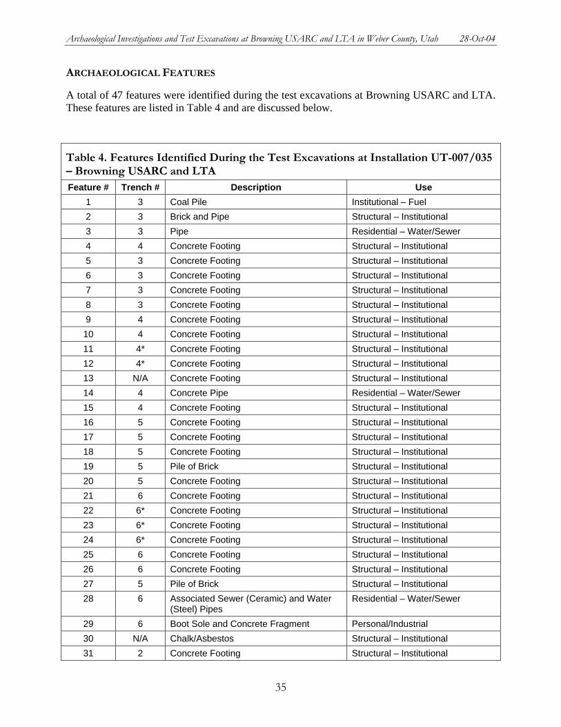
Archaeological Investigations and Test Excavations at Browning USARC and LTA in Weber County, Utah 28-Oct-04
ARCHAEOLOGICAL FEATURES
A total of 47 features were identified during the test excavations at Browning USARC and LTA. These features are listed in Table 4 and are discussed below.
Table 4. Features Identified During the Test Excavations at Installation UT-007/035 – Browning USARC and LTA Feature # Trench # Description Use
1 3 Coal Pile Institutional – Fuel 2 3 Brick and Pipe Structural – Institutional 3 3 Pipe Residential – Water/Sewer 4 4 Concrete Footing Structural – Institutional 5 3 Concrete Footing Structural – Institutional 6 3 Concrete Footing Structural – Institutional 7 3 Concrete Footing Structural – Institutional 8 3 Concrete Footing Structural – Institutional 9 4 Concrete Footing Structural – Institutional 10 4 Concrete Footing Structural – Institutional 11 4* Concrete Footing Structural – Institutional 12 4* Concrete Footing Structural – Institutional 13 N/A Concrete Footing Structural – Institutional 14 4 Concrete Pipe Residential – Water/Sewer 15 4 Concrete Footing Structural – Institutional 16 5 Concrete Footing Structural – Institutional 17 5 Concrete Footing Structural – Institutional 18 5 Concrete Footing Structural – Institutional 19 5 Pile of Brick Structural – Institutional 20 5 Concrete Footing Structural – Institutional 21 6 Concrete Footing Structural – Institutional 22 6* Concrete Footing Structural – Institutional 23 6* Concrete Footing Structural – Institutional 24 6* Concrete Footing Structural – Institutional 25 6 Concrete Footing Structural – Institutional 26 6 Concrete Footing Structural – Institutional 27 5 Pile of Brick Structural – Institutional 28 6 Associated Sewer (Ceramic) and Water
(Steel) Pipes Residential – Water/Sewer
29 6 Boot Sole and Concrete Fragment Personal/Industrial 30 N/A Chalk/Asbestos Structural – Institutional 31 2 Concrete Footing Structural – Institutional
35
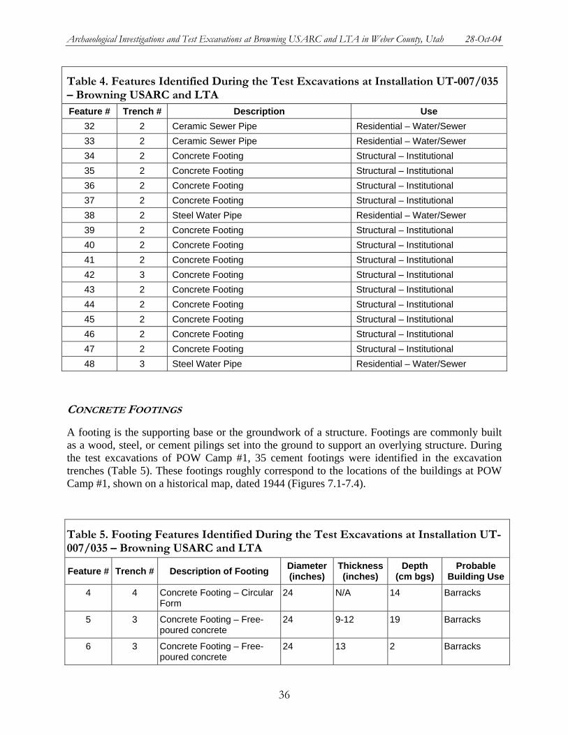
Archaeological Investigations and Test Excavations at Browning USARC and LTA in Weber County, Utah 28-Oct-04
Table 4. Features Identified During the Test Excavations at Installation UT-007/035 – Browning USARC and LTA Feature # Trench # Description Use
32 2 Ceramic Sewer Pipe Residential – Water/Sewer 33 2 Ceramic Sewer Pipe Residential – Water/Sewer 34 2 Concrete Footing Structural – Institutional 35 2 Concrete Footing Structural – Institutional 36 2 Concrete Footing Structural – Institutional 37 2 Concrete Footing Structural – Institutional 38 2 Steel Water Pipe Residential – Water/Sewer 39 2 Concrete Footing Structural – Institutional 40 2 Concrete Footing Structural – Institutional 41 2 Concrete Footing Structural – Institutional 42 3 Concrete Footing Structural – Institutional 43 2 Concrete Footing Structural – Institutional 44 2 Concrete Footing Structural – Institutional 45 2 Concrete Footing Structural – Institutional 46 2 Concrete Footing Structural – Institutional 47 2 Concrete Footing Structural – Institutional 48 3 Steel Water Pipe Residential – Water/Sewer
CONCRETE FOOTINGS
A footing is the supporting base or the groundwork of a structure. Footings are commonly built as a wood, steel, or cement pilings set into the ground to support an overlying structure. During the test excavations of POW Camp #1, 35 cement footings were identified in the excavation trenches (Table 5). These footings roughly correspond to the locations of the buildings at POW Camp #1, shown on a historical map, dated 1944 (Figures 7.1-7.4).
Table 5. Footing Features Identified During the Test Excavations at Installation UT-007/035 – Browning USARC and LTA
Feature # Trench # Description of Footing Diameter (inches)
Thickness (inches)
Depth (cm bgs)
Probable Building Use
4 4 Concrete Footing – Circular Form
24 N/A 14 Barracks
5 3 Concrete Footing – Free-poured concrete
24 9-12 19 Barracks
6 3 Concrete Footing – Free-poured concrete
24 13 2 Barracks
36
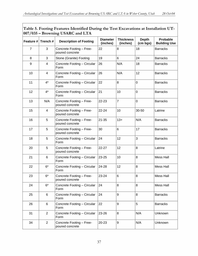
Archaeological Investigations and Test Excavations at Browning USARC and LTA in Weber County, Utah 28-Oct-04
Table 5. Footing Features Identified During the Test Excavations at Installation UT-007/035 – Browning USARC and LTA
Feature # Trench # Description of Footing Diameter (inches)
Thickness (inches)
Depth (cm bgs)
Probable Building Use
7 3 Concrete Footing – Free-poured concrete
22 8 18 Barracks
8 3 Stone (Granite) Footing 19 6 24 Barracks
9 4 Concrete Footing – Circular Form
26 N/A 18 Barracks
10 4 Concrete Footing – Circular Form
26 N/A 12 Barracks
11 4* Concrete Footing – Circular Form
22 8 0 Barracks
12 4* Concrete Footing – Circular Form
21 10 0 Barracks
13 N/A Concrete Footing – Free-poured concrete
22-23 7 0 Barracks
15 4 Concrete Footing – Free-poured concrete
22-24 10 30-50 Latrine
16 5 Concrete Footing – Free-poured concrete
21-35 13+ N/A Barracks
17 5 Concrete Footing – Free-poured concrete
30 6 17 Barracks
18 5 Concrete Footing – Circular Form
24 12 3 Barracks
20 5 Concrete Footing – Free-poured concrete
22-27 12 8 Latrine
21 6 Concrete Footing – Circular Form
23-25 10 8 Mess Hall
22 6* Concrete Footing – Circular Form
24-28 12 8 Mess Hall
23 6* Concrete Footing – Free-poured concrete
23-24 6 8 Mess Hall
24 6* Concrete Footing – Circular Form
24 8 8 Mess Hall
25 6 Concrete Footing – Circular Form
24 9 8 Barracks
26 6 Concrete Footing – Circular Form
22 9 5 Barracks
31 2 Concrete Footing – Circular Form
23-26 8 N/A Unknown
34 2 Concrete Footing – Free-poured concrete
20-23 9 N/A Unknown
37
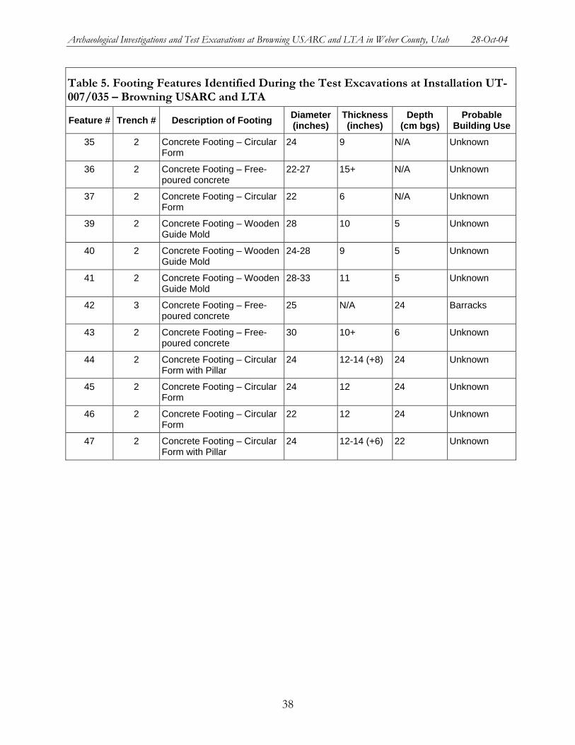
Archaeological Investigations and Test Excavations at Browning USARC and LTA in Weber County, Utah 28-Oct-04
Table 5. Footing Features Identified During the Test Excavations at Installation UT-007/035 – Browning USARC and LTA
Feature # Trench # Description of Footing Diameter (inches)
Thickness (inches)
Depth (cm bgs)
Probable Building Use
35 2 Concrete Footing – Circular Form
24 9 N/A Unknown
36 2 Concrete Footing – Free-poured concrete
22-27 15+ N/A Unknown
37 2 Concrete Footing – Circular Form
22 6 N/A Unknown
39 2 Concrete Footing – Wooden Guide Mold
28 10 5 Unknown
40 2 Concrete Footing – Wooden Guide Mold
24-28 9 5 Unknown
41 2 Concrete Footing – Wooden Guide Mold
28-33 11 5 Unknown
42 3 Concrete Footing – Free-poured concrete
25 N/A 24 Barracks
43 2 Concrete Footing – Free-poured concrete
30 10+ 6 Unknown
44 2 Concrete Footing – Circular Form with Pillar
24 12-14 (+8) 24 Unknown
45 2 Concrete Footing – Circular Form
24 12 24 Unknown
46 2 Concrete Footing – Circular Form
22 12 24 Unknown
47 2 Concrete Footing – Circular Form with Pillar
24 12-14 (+6) 22 Unknown
38

Archaeological Investigations and Test Excavations at Browning USARC and LTA in Weber County, Utah 28-Oct-04
Figure 7.1. Map key for the location of footings and other features along the trenches of POW Camp #1 (Site 42Wb000420).
39

Archaeological Investigations and Test Excavations at Browning USARC and LTA in Weber County, Utah 28-Oct-04
Figure 7.2. Locations of footings and other features in Testing Area #1 along the trenches of POW Camp #1 (Site 42Wb000420).
40

Archaeological Investigations and Test Excavations at Browning USARC and LTA in Weber County, Utah 28-Oct-04
Figure 7.3. Locations of footings and other features in Testing Area #2 along the trenches of POW Camp #1 (Site 42Wb000420).
41

Archaeological Investigations and Test Excavations at Browning USARC and LTA in Weber County, Utah 28-Oct-04
Figure 7.4. Locations of footings and other features in Testing Area #3 along the trenches of POW Camp #1 (Site 42Wb000420).
42
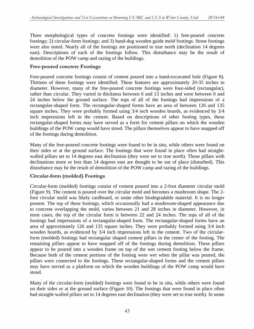
Archaeological Investigations and Test Excavations at Browning USARC and LTA in Weber County, Utah 28-Oct-04
Three morphological types of concrete footings were identified: 1) free-poured concrete footings; 2) circular-form footings; and 3) hand-dug wooden guide mold footings. Stone footings were also noted. Nearly all of the footings are positioned to true north (declination 14 degrees east). Descriptions of each of the footings follow. This disturbance may be the result of demolition of the POW camp and razing of the buildings.
Free-poured concrete Footings
Free-poured concrete footings consist of cement poured into a hand-excavated hole (Figure 8). Thirteen of these footings were identified. These features are approximately 20-35 inches in diameter. However, many of the free-poured concrete footings were four-sided (rectangular), rather than circular. They varied in thickness between 6 and 13 inches and were between 0 and 24 inches below the ground surface. The tops of all of the footings had impressions of a rectangular-shaped form. The rectangular-shaped forms have an area of between 126 and 135 square inches. They were probably formed using 3/4 inch wooden boards, as evidenced by 3/4 inch impressions left in the cement. Based on descriptions of other footing types, these rectangular-shaped forms may have served as a form for cement pillars on which the wooden buildings of the POW camp would have stood. The pillars themselves appear to have snapped off of the footings during demolition.
Many of the free-poured concrete footings were found to be in situ, while others were found on their sides or at the ground surface. The footings that were found in place often had straight-walled pillars set to 14 degrees east declination (they were set to true north). Those pillars with declinations more or less than 14 degrees east are thought to be out of place (disturbed). This disturbance may be the result of demolition of the POW camp and razing of the buildings.
Circular-form (molded) Footings
Circular-form (molded) footings consist of cement poured into a 2-foot diameter circular mold (Figure 9). The cement is poured over the circular mold and becomes a mushroom shape. The 2-foot circular mold was likely cardboard, or some other biodegradable material. It is no longer present. The top of these footings, which occasionally had a mushroom-shaped appearance due to concrete overlapping the mold, varies between 21 and 28 inches in diameter. However, in most cases, the top of the circular form is between 22 and 24 inches. The tops of all of the footings had impressions of a rectangular-shaped form. The rectangular-shaped forms have an area of approximately 126 and 135 square inches. They were probably formed using 3/4 inch wooden boards, as evidenced by 3/4 inch impressions left in the cement. Two of the circular-form (molded) footings had rectangular shaped cement pillars in the center of the footing. The remaining pillars appear to have snapped off of the footings during demolition. These pillars appear to be poured into a wooden frame on top of the wet cement footing below the frame. Because both of the cement portions of the footing were wet when the pillar was poured, the pillars were connected to the footings. These rectangular-shaped forms and the cement pillars may have served as a platform on which the wooden buildings of the POW camp would have stood.
Many of the circular-form (molded) footings were found to be in situ, while others were found on their sides or at the ground surface (Figure 10). The footings that were found in place often had straight-walled pillars set to 14 degrees east declination (they were set to true north). In some
43
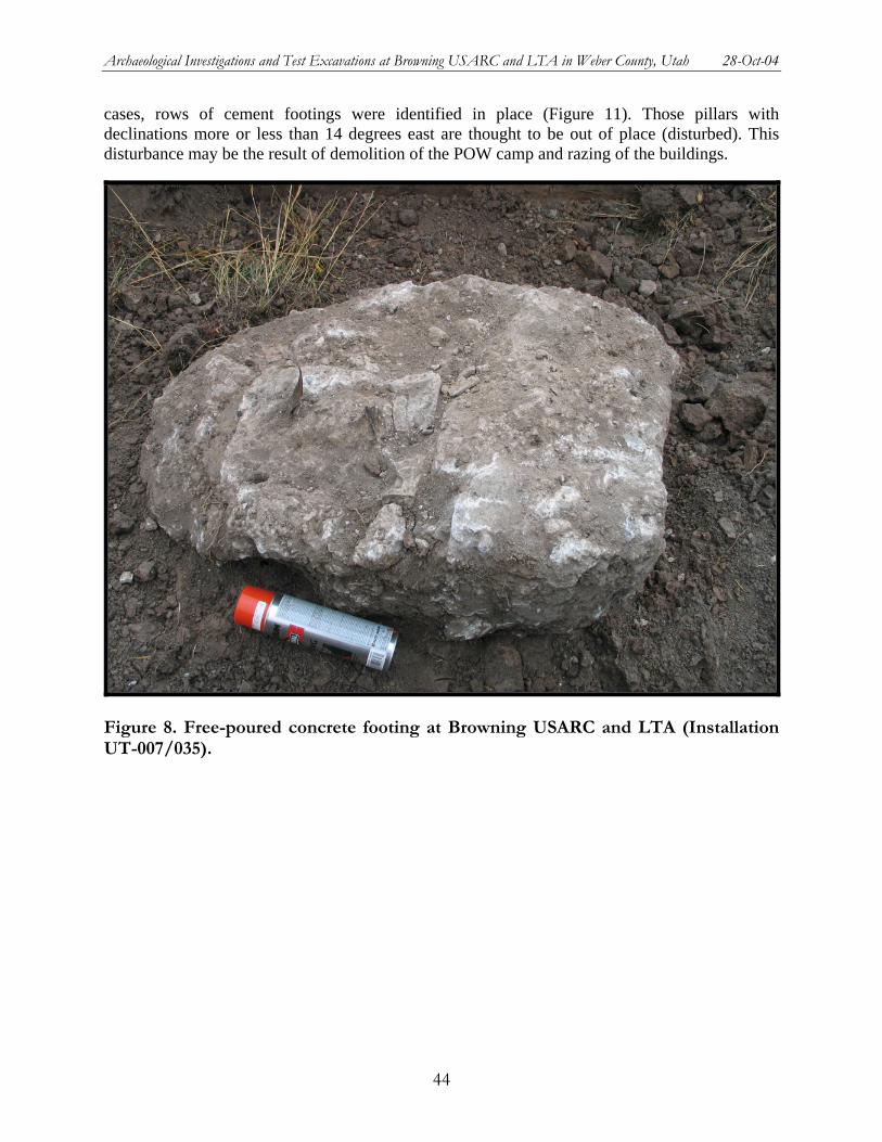
Archaeological Investigations and Test Excavations at Browning USARC and LTA in Weber County, Utah 28-Oct-04
cases, rows of cement footings were identified in place (Figure 11). Those pillars with declinations more or less than 14 degrees east are thought to be out of place (disturbed). This disturbance may be the result of demolition of the POW camp and razing of the buildings.
Figure 8. Free-poured concrete footing at Browning USARC and LTA (Installation UT-007/035).
44

Archaeological Investigations and Test Excavations at Browning USARC and LTA in Weber County, Utah 28-Oct-04
Figure 9. Circular-form (molded) footing at Browning USARC and LTA (Installation UT-007/035).
45
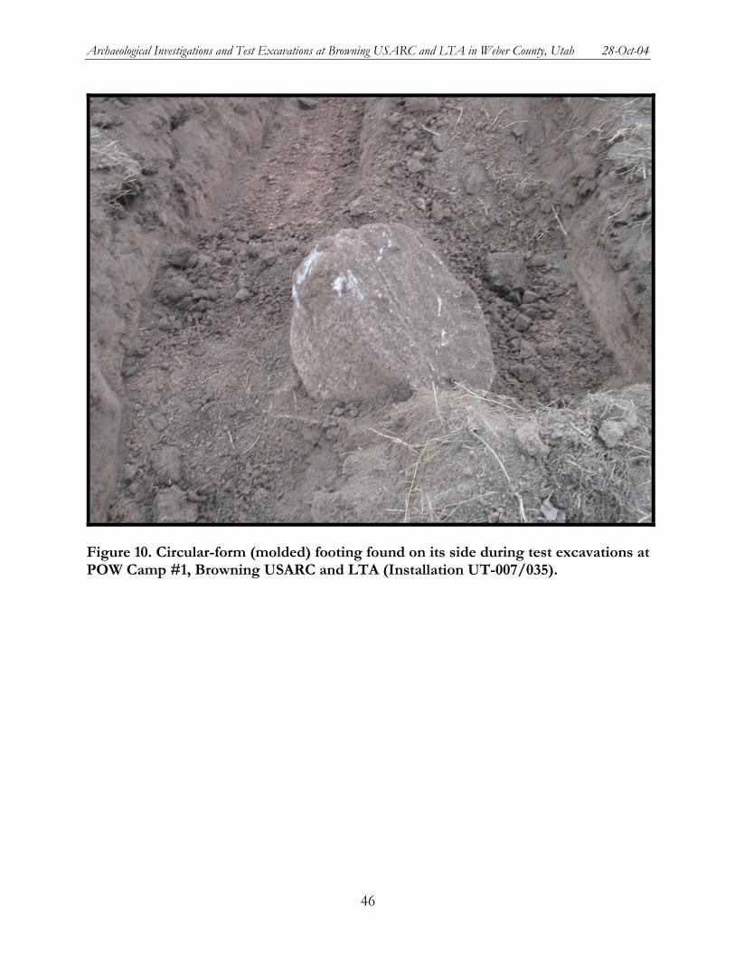
Archaeological Investigations and Test Excavations at Browning USARC and LTA in Weber County, Utah 28-Oct-04
Figure 10. Circular-form (molded) footing found on its side during test excavations at POW Camp #1, Browning USARC and LTA (Installation UT-007/035).
46
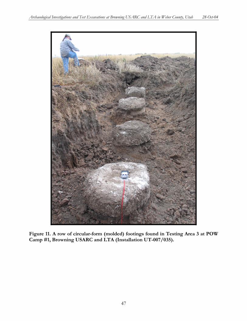
Archaeological Investigations and Test Excavations at Browning USARC and LTA in Weber County, Utah 28-Oct-04
Figure 11. A row of circular-form (molded) footings found in Testing Area 3 at POW Camp #1, Browning USARC and LTA (Installation UT-007/035).
47

Archaeological Investigations and Test Excavations at Browning USARC and LTA in Weber County, Utah 28-Oct-04
Hand-dug Wooden Guide-mold Footings
Hand-dug wooden guide-mold footings consist of cement poured into a hand excavated hole in which one or two sides were lined with wooden lathe "guides" (Figure 12). The lathe "guides" were set up on the east and south sides of three of the footings at in the northeastern portion of Prison Camp #1. The lathe "guides" are composed of 1/4 inch wood lathe, laid the length of the footing, stacked one on top of the other. Two additional pieces of lathe were placed on the outer edges of the interior lathe to support the frame. These features are set up in a parallelogram approximately 28-33 inches from side to side. The depth of the wooden lathe "guides" are between 9 and 11 inches. All of these footings are approximately 5 inches below the modern ground surface. The tops of all of the footings had impressions of a rectangular-shaped form. The rectangular-shaped forms have an area of approximately 126 and 135 square inches. They were probably formed using 3/4 inch wooden boards, as evidenced by 3/4 inch impressions left in the cement. Based on descriptions of other footing types, these rectangular-shaped forms may have served as a form for cement pillars on which the wooden buildings of the POW camp would have stood. The pillars themselves appear to have snapped off of the footings during demolition.
Many of the hand-dug wooden guide-mold footings were found to be in situ, while others were found on their sides or at the ground surface. The footings that were found in place often had straight-walled pillars set to 14 degrees east declination (they were set to true north). Those pillars with declinations more or less than 14 degrees east are thought to be out of place (disturbed). This disturbance may be the result of demolition of the POW camp and razing of the buildings.
Stone Footings
One stone footing was identified during the excavation of Prison Camp #1 (Figure 13). The stone footing appears to be composed of granite and is 19 inches square. It is 6 inches thick and was buried beneath 24 inches of sediment. The origin of this footing is unknown.
STEEL WATER PIPES
A total of 5 steel water pipes were identified during the test excavations at POW Camp #1 (Table 6). All of the steel pipes were rusted, but were in good condition. They consist of a 2 1/2 inch diameter steel pipe with plumbed corners and were fitted with rubber seals (Figure 14). One steel pipe (Feature #48) appeared to be cut using a plasma-cutter (probably during demolition of the POW camp). The others were completely subsurface (usually about 6-12 inches below the ground surface) and laid horizontally. These features appeared to supply running water to the POW Camp #1 laundry facilities, kitchens, and lavatories.
One steel water pipe was located inside a ceramic sewer pipe (F-28). It is possible that this steel water pipe served to flush out the sewer pipes.
48
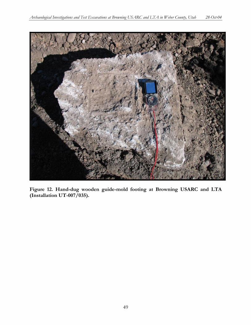
Archaeological Investigations and Test Excavations at Browning USARC and LTA in Weber County, Utah 28-Oct-04
Figure 12. Hand-dug wooden guide-mold footing at Browning USARC and LTA (Installation UT-007/035).
49
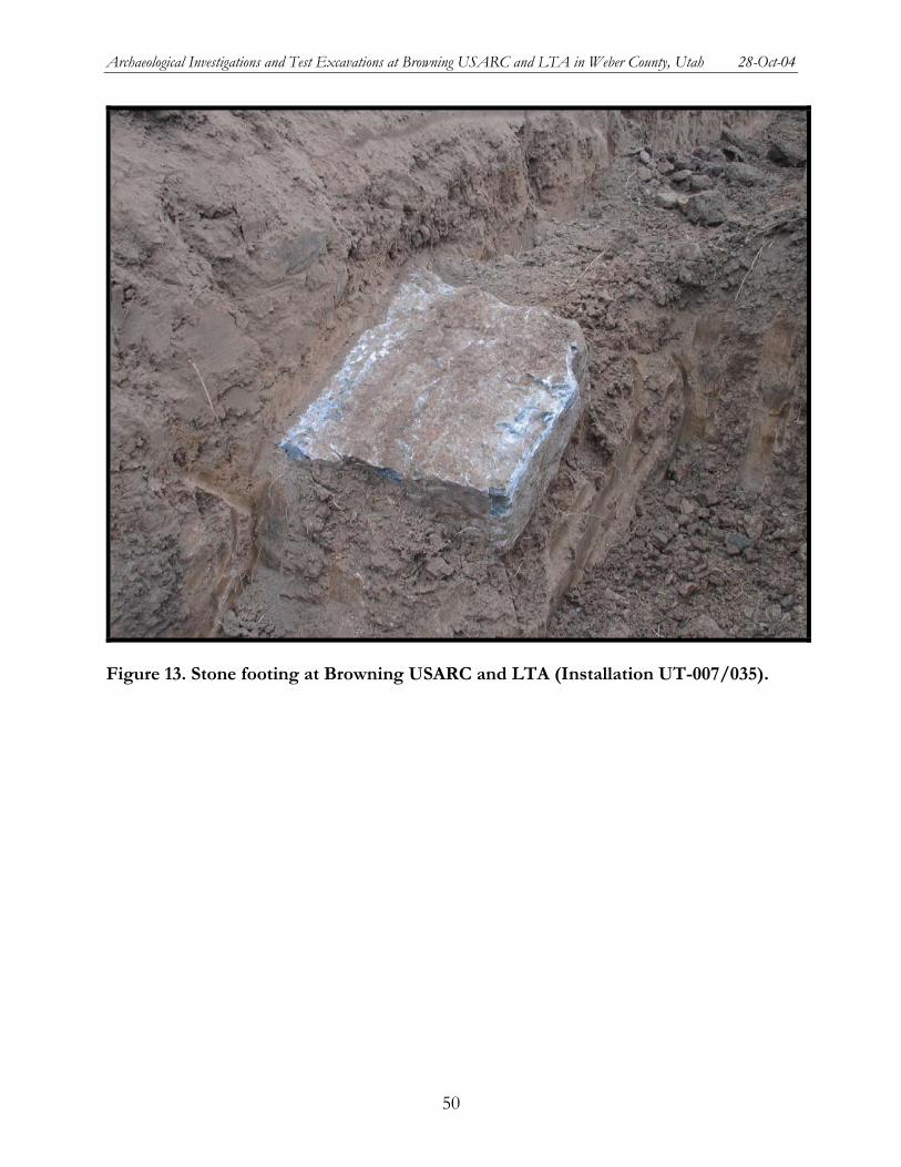
Archaeological Investigations and Test Excavations at Browning USARC and LTA in Weber County, Utah 28-Oct-04
Figure 13. Stone footing at Browning USARC and LTA (Installation UT-007/035).
50
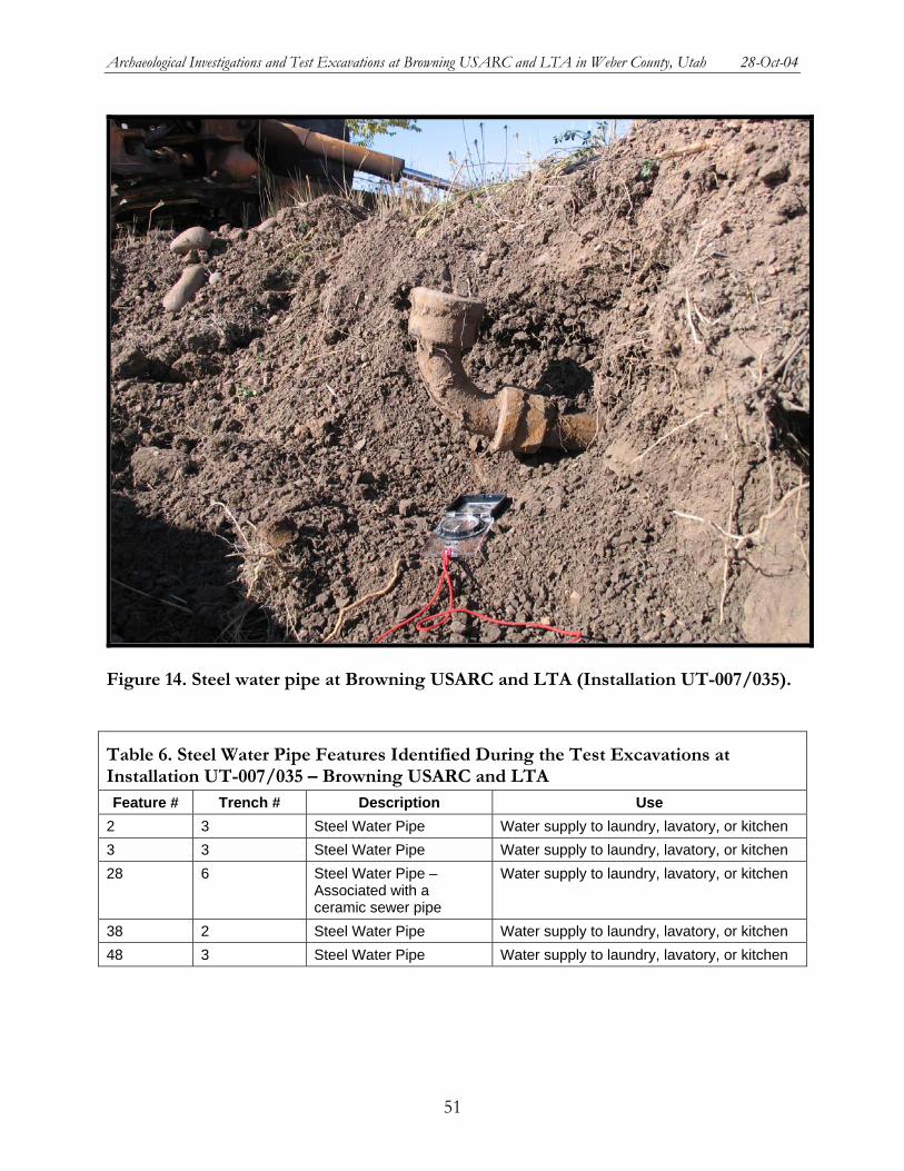
Archaeological Investigations and Test Excavations at Browning USARC and LTA in Weber County, Utah 28-Oct-04
Figure 14. Steel water pipe at Browning USARC and LTA (Installation UT-007/035).
Table 6. Steel Water Pipe Features Identified During the Test Excavations at Installation UT-007/035 – Browning USARC and LTA Feature # Trench # Description Use
2 3 Steel Water Pipe Water supply to laundry, lavatory, or kitchen 3 3 Steel Water Pipe Water supply to laundry, lavatory, or kitchen 28 6 Steel Water Pipe –
Associated with a ceramic sewer pipe
Water supply to laundry, lavatory, or kitchen
38 2 Steel Water Pipe Water supply to laundry, lavatory, or kitchen 48 3 Steel Water Pipe Water supply to laundry, lavatory, or kitchen
51
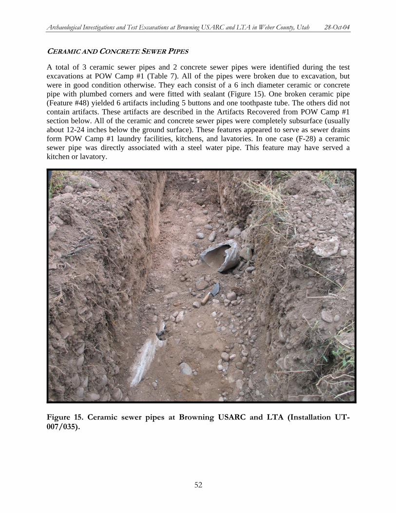
Archaeological Investigations and Test Excavations at Browning USARC and LTA in Weber County, Utah 28-Oct-04
CERAMIC AND CONCRETE SEWER PIPES
A total of 3 ceramic sewer pipes and 2 concrete sewer pipes were identified during the test excavations at POW Camp #1 (Table 7). All of the pipes were broken due to excavation, but were in good condition otherwise. They each consist of a 6 inch diameter ceramic or concrete pipe with plumbed corners and were fitted with sealant (Figure 15). One broken ceramic pipe (Feature #48) yielded 6 artifacts including 5 buttons and one toothpaste tube. The others did not contain artifacts. These artifacts are described in the Artifacts Recovered from POW Camp #1 section below. All of the ceramic and concrete sewer pipes were completely subsurface (usually about 12-24 inches below the ground surface). These features appeared to serve as sewer drains form POW Camp #1 laundry facilities, kitchens, and lavatories. In one case (F-28) a ceramic sewer pipe was directly associated with a steel water pipe. This feature may have served a kitchen or lavatory.
Figure 15. Ceramic sewer pipes at Browning USARC and LTA (Installation UT-007/035).
52
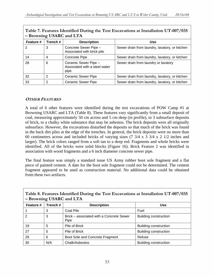
Archaeological Investigations and Test Excavations at Browning USARC and LTA in Weber County, Utah 28-Oct-04
Table 7. Features Identified During the Test Excavations at Installation UT-007/035 – Browning USARC and LTA Feature # Trench # Description Use 2 3 Concrete Sewer Pipe –
Associated with brick pile Sewer drain from laundry, lavatory, or kitchen
14 4 Concrete Pipe Sewer drain from laundry, lavatory, or kitchen 28 6 Ceramic Sewer Pipe –
Associated with a steel water pipe
Sewer drain from laundry or lavatory
32 2 Ceramic Sewer Pipe Sewer drain from laundry, lavatory, or kitchen 33 2 Ceramic Sewer Pipe Sewer drain from laundry, lavatory, or kitchen
OTHER FEATURES
A total of 6 other features were identified during the test excavations of POW Camp #1 at Browning USARC and LTA (Table 8). These features vary significantly from a small deposit of coal, measuring approximately 50 cm across and 5 cm deep (in profile), to 3 subsurface deposits of brick, to a chalky white substance that may be asbestos. The brick deposits were all originally subsurface. However, the excavations disturbed the deposits so that much of the brick was found in the back dirt piles at the edge of the trenches. In general, the brick deposits were no more than 60 centimeters across and included bricks of varying sizes (7 3/4 x 3 3/4 x 2 1/2 inches and larger). The brick colors ranged from a soft tan to a deep red. Fragments and whole bricks were identified. All of the bricks were solid blocks (Figure 16). Brick Feature 2 was identified in association with wood fragments and a 6 inch diameter concrete sewer pipe.
The final feature was simply a standard issue US Army rubber boot sole fragment and a flat piece of painted cement. A date for the boot sole fragment could not be determined. The cement fragment appeared to be used as construction material. No additional data could be obtained from these two artifacts.
Table 8. Features Identified During the Test Excavations at Installation UT-007/035 – Browning USARC and LTA Feature # Trench # Description Use 1 3 Coal Pile Fuel 2 3 Brick – associated with a Concrete Sewer
Pipe Building construction
19 5 Pile of Brick Building construction 27 5 Pile of Brick Building construction 29 6 Boot Sole and Concrete Fragment Refuse 30 N/A Chalk/Asbestos Building construction
53
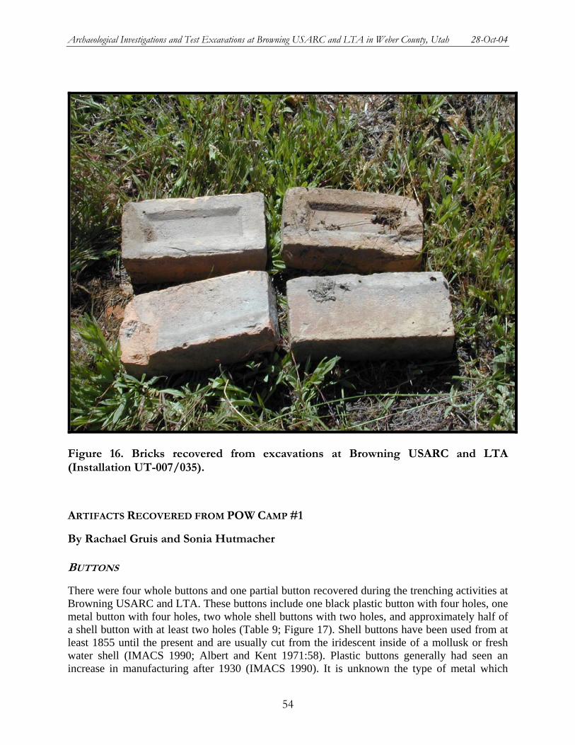
Archaeological Investigations and Test Excavations at Browning USARC and LTA in Weber County, Utah 28-Oct-04
Figure 16. Bricks recovered from excavations at Browning USARC and LTA (Installation UT-007/035).
ARTIFACTS RECOVERED FROM POW CAMP #1
By Rachael Gruis and Sonia Hutmacher
BUTTONS
There were four whole buttons and one partial button recovered during the trenching activities at Browning USARC and LTA. These buttons include one black plastic button with four holes, one metal button with four holes, two whole shell buttons with two holes, and approximately half of a shell button with at least two holes (Table 9; Figure 17). Shell buttons have been used from at least 1855 until the present and are usually cut from the iridescent inside of a mollusk or fresh water shell (IMACS 1990; Albert and Kent 1971:58). Plastic buttons generally had seen an increase in manufacturing after 1930 (IMACS 1990). It is unknown the type of metal which
54
Archaeological Investigations and Test Excavations at Browning USARC and LTA in Weber County, Utah 28-Oct-04
Figure 17. Buttons recovered from Browning trenching activities:(a) plastic; (b) metal; (c-e) shell.
comprises the metal button recovered from the trenching activities. Brass was a common metal used for buttons since the 1800s for men's clothing and uniforms, however this button was too degraded for determination. However, it could be inferred that the button was likely produced and used after the (IMACS 1990).
55
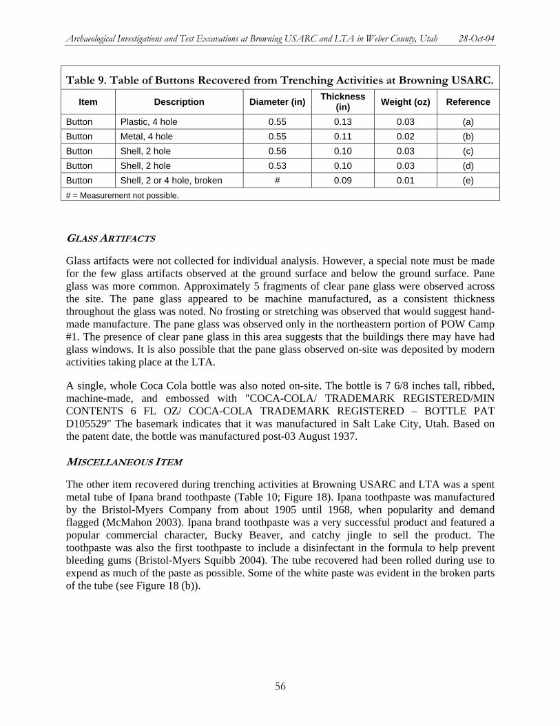
Archaeological Investigations and Test Excavations at Browning USARC and LTA in Weber County, Utah 28-Oct-04
Table 9. Table of Buttons Recovered from Trenching Activities at Browning USARC.
Item Description Diameter (in) Thickness (in) Weight (oz) Reference
Button Plastic, 4 hole 0.55 0.13 0.03 (a) Button Metal, 4 hole 0.55 0.11 0.02 (b) Button Shell, 2 hole 0.56 0.10 0.03 (c) Button Shell, 2 hole 0.53 0.10 0.03 (d) Button Shell, 2 or 4 hole, broken # 0.09 0.01 (e) # = Measurement not possible.
GLASS ARTIFACTS
Glass artifacts were not collected for individual analysis. However, a special note must be made for the few glass artifacts observed at the ground surface and below the ground surface. Pane glass was more common. Approximately 5 fragments of clear pane glass were observed across the site. The pane glass appeared to be machine manufactured, as a consistent thickness throughout the glass was noted. No frosting or stretching was observed that would suggest hand-made manufacture. The pane glass was observed only in the northeastern portion of POW Camp #1. The presence of clear pane glass in this area suggests that the buildings there may have had glass windows. It is also possible that the pane glass observed on-site was deposited by modern activities taking place at the LTA.
A single, whole Coca Cola bottle was also noted on-site. The bottle is 7 6/8 inches tall, ribbed, machine-made, and embossed with "COCA-COLA/ TRADEMARK REGISTERED/MIN CONTENTS 6 FL OZ/ COCA-COLA TRADEMARK REGISTERED – BOTTLE PAT D105529" The basemark indicates that it was manufactured in Salt Lake City, Utah. Based on the patent date, the bottle was manufactured post-03 August 1937.
MISCELLANEOUS ITEM
The other item recovered during trenching activities at Browning USARC and LTA was a spent metal tube of Ipana brand toothpaste (Table 10; Figure 18). Ipana toothpaste was manufactured by the Bristol-Myers Company from about 1905 until 1968, when popularity and demand flagged (McMahon 2003). Ipana brand toothpaste was a very successful product and featured a popular commercial character, Bucky Beaver, and catchy jingle to sell the product. The toothpaste was also the first toothpaste to include a disinfectant in the formula to help prevent bleeding gums (Bristol-Myers Squibb 2004). The tube recovered had been rolled during use to expend as much of the paste as possible. Some of the white paste was evident in the broken parts of the tube (see Figure 18 (b)).
56
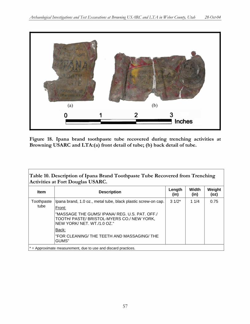
Archaeological Investigations and Test Excavations at Browning USARC and LTA in Weber County, Utah 28-Oct-04
Figure 18. Ipana brand toothpaste tube recovered during trenching activities at Browning USARC and LTA:(a) front detail of tube; (b) back detail of tube.
Table 10. Description of Ipana Brand Toothpaste Tube Recovered from Trenching Activities at Fort Douglas USARC.
Item Description Length (in)
Width (in)
Weight (oz)
Toothpaste tube
Ipana brand, 1.0 oz., metal tube, black plastic screw-on cap.Front: "MASSAGE THE GUMS/ IPANA/ REG. U.S. PAT. OFF./ TOOTH/ PASTE/ BRISTOL-MYERS CO./ NEW YORK, NEW YORK/ NET. WT./1.0 OZ." Back: "FOR CLEANING/ THE TEETH AND MASSAGING/ THE GUMS"
3 1/2* 1 1/4 0.75
* = Approximate measurement, due to use and discard practices.
57
Archaeological Investigations and Test Excavations at Browning USARC and LTA in Weber County, Utah 28-Oct-04
SUMMARY OF ARTIFACTS
Although the quantity of artifacts recovered from the trenching activities at the POW Camp #1 is extremely limited, some basic information regarding types of activities and chronology of those activities can be inferred. The types of artifacts being discarded in the general area of the trenches indicates that domestic debris was discarded, i.e., shirt buttons, a coca cola bottle, and an empty toothpaste tube. The date range for the buttons is broad, but generally suggests use and discard after 1855, but more likely after the 1930s or 1940s. The tube of toothpaste has a more narrow date range from approximately 1905 to 1968. This suggests that the artifacts identified at POW Camp #1 were likely discarded sometime between 1937 and 1968, securely within the World War II occupation of the prison camp.
NATIONAL REGISTER OF HISTORIC PLACES ELIGIBILITY RECOMMENDATIONS
Site 42Wb000420 is the remains of Prisoner-of-War (POW) Camp #1, formerly part of Defense Depot Ogden, Utah (DDO; Site 42Wb000421). During this portion of the contract, POW Camp #1 was tested for presence and eligibility. A total of 48 features were identified during the test excavations. The majority of these features were cement footings. Although a number of these were found in place, many of the footings appeared to be affected by camp razing and subsequent activities. Cement, steel, and ceramic pipes were also identified. These pipes may have served the POW camp as sewer and water supplies. Several buttons and other artifacts were also identified during the testing. No other significant remains of the camp—barrack portions, floor remnants, pathway and other landscape features, trash deposits, etc. were identified in the testing. Aside from a few out of place footing remnants, no camp remnants are visible on the modern ground surface.
Overall, Site 42WB000420 does not appear to have sufficient integrity to merit eligibility to the National Register of Historic Places. While the camp does have integrity of location, it lacks integrity of design, setting, materials, workmanship, feeling, and association. Because much of the camp has been razed, very little of the original camp design remains. The testing did indicate that footings and some camp infrastructure such as water and sewer pipes remain. However, all of the footings have been damaged and more than a few have been moved out of place during camp razing and/or subsequent activities, and the intact remnants of water and sewage systems can only be considered a minor component of the overall design of the camp. Thus, the original design of the camp has been seriously compromised by razing and other activities. In a similar manner, integrity of materials and workmanship has been lost. Only small portions of the original materials and workmanship of the camp construction remain, and even these have been altered by camp razing and destruction.
Integrity of setting, feeling, and association has also been lost. Much of the area around the former POW camp has been reworked in the last 50 years. New buildings have been constructed, new housing developments are in place, that the area now appears to be a light industrial park rather than a former Army base. Furthermore, because no significant remains of the camp are visible on the current surface, the property does not convey any feeling of its original function and cannot be associated with the period of significance when it was used to house prisoners. Testing indicated that even excavation or clearing of the surface would not yield significant and readily identifiable aspects of the camp. While footings are present, many are out of place and
58
Archaeological Investigations and Test Excavations at Browning USARC and LTA in Weber County, Utah 28-Oct-04
some are missing. Thus, the camp neither has its original integrity of setting, feeling, and association and it isn't likely that such integrity could be restored.
Finally, the potential of the site to address research questions is limited to non-existent. Test excavations were remarkable for the paucity of artifacts recovered. Despite large volumes of testing within, around, and outside of building areas, very few artifacts were found. Although the location of the original trash deposits for the camp remains unknown, it does not appear likely that they are currently located on site. Historical information suggesting the presence of incinerators to the south of the camp suggests that trash was probably burned. Thus, there is limited potential for the site to provide evidence to address research questions. Finally, the removal of much of the original camp and the disturbance of the remaining footings also reduces the potential of the extant remains to address research questions.
Therefore, due to the lack of historical integrity to the site, SWCA recommends that Site 42WB000420 is not eligible to the National Register of Historic Places.
59
Archaeological Investigations and Test Excavations at Browning USARC and LTA in Weber County, Utah 28-Oct-04
MANAGEMENT SUMMARY
In November 2003, the United States Army Reserve (USAR), 96th Regional Readiness Command (RRC) requested that SWCA, Inc. Environmental Consultants (SWCA) conduct cultural resources inventories of US Army Reserve facilities located within the command’s Area of Operations. The purpose of these inventories is to maintain the 96th RRC's compliance with Sections 106, 110, and 111 of the National Historic Preservation of 1966 (NHPA). This involves the identification, evaluation, and nomination of all historic properties within the Montana, Utah, Colorado, North Dakota, and South Dakota Area of Operations. In September 2004, following the initiation of the aforementioned inventories, the 96th RRC proposed construction of a new USARC within the Browning installation boundary. The 96th RRC requested that SWCA finalize cultural resource evaluations at the Browning USARC and LTA in order to address any issues required for compliance with Section 106 of the NHPA that could arise from the development of a new USARC. The Browning USARC and LTA consist of a block survey area, encompassing approximately 153 acres (61.92 hectares). SWCA carried out a pedestrian inventory within the boundary of the USARC and LTA. Two archaeologists conducted a Class III cultural resources inventory of Browning USARC and LTA using 15 meter (50 foot) transect intervals. Because the project falls under the jurisdiction of the USAR 96th RRC, the command’s environmental office is acting as the lead agency on this project. In order to maintain compliance with Section 106 of the NHPA, the lead agency will consult the Utah State Historic Preservation Office in order to request concurrence with its determination with regard to the proposed undertaking.
Two archaeological sites were identified within the boundaries of the Browning USARC and LTA. One site (Site 42Wb000420) was identified during the Class I file search conducted at the USARC State Engineering Office. This site exists within the Browning LTA (Installation UT-035) to the south of the Browning USARC (Installation UT-007). Site 42WB000420 is the remains of Prisoner-of-War (POW) Camp #1, formerly part of Defense Depot Ogden, Utah (DDO; Site 42Wb000421). During portion of the contract, POW Camp #1 was tested for presence and eligibility. A total of 48 features were identified during the test excavations. The majority of these features were cement footings. Most were found in place. However, all of the footings appeared to be affected by razing. Cement, steel, and ceramic pipes were also identified. These pipes may have served the POW camp as sewer and water supplies. Several buttons and other artifacts were also identified during the testing.
Site 42WB000420 is the remains of Prisoner-of-War (POW) Camp #1, formerly part of Defense Depot Ogden, Utah (DDO; Site 42Wb000421). During this portion of the contract, POW Camp #1 was tested for presence and eligibility. A total of 48 features were identified during the test excavations. The majority of these features were cement footings. Although a number of these were found in place, many of the footings appeared to be affected by camp razing and subsequent activities. Cement, steel, and ceramic pipes were also identified. These pipes may have served the POW camp as sewer and water supplies. Several buttons and other artifacts were also identified during the testing. No other significant remains of the camp—barrack portions,
60
Archaeological Investigations and Test Excavations at Browning USARC and LTA in Weber County, Utah 28-Oct-04
floor remnants, pathway and other landscape features, trash deposits, etc. were identified in the testing. Aside from a few out of place footing remnants, no camp remnants are visible on the modern ground surface.
Overall, Site 42WB000420 does not appear to have sufficient integrity to merit eligibility to the National Register of Historic Places. While the camp does have integrity of location, it lacks integrity of design, setting, materials, workmanship, feeling, and association. Because much of the camp has been razed, very little of the original camp design remains. The testing did indicate that footings and some camp infrastructure such as water and sewer pipes remain. However, all of the footings have been damaged and many have been moved out of place during camp razing and/or subsequent activities, and the intact remnants of water and sewage systems can only be considered a minor component of the overall design of the camp. Thus, the original design of the camp has been seriously compromised by razing and other activities. In a similar manner, integrity of materials and workmanship has been lost. Only small portions of the original materials and workmanship of the camp construction remain, and even these have been altered by camp razing and destruction.
Integrity of setting, feeling, and association has also been lost. Much of the area around the former POW camp has been reworked in the last 50 years. New buildings have been constructed, new housing developments are in place, that the area now appears to be a light industrial park rather than a former Army base. Furthermore, because no significant remains of the camp are visible on the current surface, the property does not convey any feeling of its original function and cannot be associated with the period of significance when it was used to house prisoners. Testing indicated that even excavation or clearing of the surface would not yield significant and readily identifiable aspects of the camp. While footings are present, many are out of place and some are missing. Thus, the camp neither has its original integrity of setting, feeling, and association and it isn't likely that such integrity could be restored.
Finally, the potential of the site to address research questions is limited to non-existent. Test excavations were remarkable for the paucity of artifacts recovered. Despite large volumes of testing within, around, and outside of building areas, very few artifacts were found. Although the location of the original trash deposits for the camp remains unknown, it does not appear likely that they are currently located on site. Historical information suggesting the presence of incinerators to the south of the camp suggests that trash was probably burned. Thus, there is limited potential for the site to provide evidence to address research questions. Finally, the removal of much of the original camp and the disturbance of the remaining footings also reduces the potential of the extant remains to address research questions.
Therefore, due to the lack of historical integrity to the site, SWCA recommends that Site 42WB000420 is not eligible to the National Register of Historic Places.
The second site is historical DDO (Site 42Wb000421). The modern location of the Browning USARC and LTA is in the northwestern portion of historical DDO. Because the entire historical facility was not recorded during this portion of the contract, and because the features identified in association with historical DDO do not retain integrity of feeling, design, setting, and association, SWCA recommends that this portion of the site is non-contributing and, therefore, the recorded portion of Site 42Wb000421 is not eligible for nomination to the NRHP.
61
Archaeological Investigations and Test Excavations at Browning USARC and LTA in Weber County, Utah 28-Oct-04
Cultural resource clearance is recommended within the existing perimeter of Browning USARC and LTA for the proposed construction of the new USARC and for any ground-disturbing activities associated with training or maintenance. Its structural and infrastructural components have not attained sufficient age to be evaluated under the criteria of the NRHP. SWCA has recommended that the two archaeological sites identified during the Class I and III cultural resources inventory and the resultant test excavations are not eligible for the NRHP. Although it is possible that significant prehistoric or historical cultural resources may be buried beneath the existing ground surface, investigations of sediments exposed during the test excavations as well as those materials available at the ground surface have not resulted in the identification of such significant materials. As such, the managers of future undertakings at this installation may request exemption from further cultural resource investigations until such time that the facilities at Browning USARC and LTA have either attained 50 years of age, or has demonstrated such extreme significance to the history of the region, state, or nation that additional consideration is warranted pursuant to the criteria of the NRHP.
The techniques employed as part of SWCA's investigation related to the Browning USARC and LTA portion of the 96th RRC contract are considered sufficient for locating and documenting cultural resources that may be present within Browning USARC and LTA and that are available for visual inspection. However, should cultural materials be discovered during construction, work should cease immediately and contact should be made with the 96th RRC environmental specialist or the Utah State Archaeologist.
62
Archaeological Investigations and Test Excavations at Browning USARC and LTA in Weber County, Utah 28-Oct-04
REFERENCES
Alder, Douglas and Ralph Busco 1971. German and Italian Prisoners of War in Utah and Idaho. Utah Historical Quarterly,
Vol. 39 pgs. 55-71.
Albert, Lillian Smith and Kathryn Kent 1971 The Complete Button Book. John Edwards, Stratford, Connecticut.
Barlow et al. 1996 Report on the Cultural Resources Inventory Survey Completed for the Proposed
WorldCom Seattle to Salt Lake City Fiber Optic Line Part 1:Utah. Northwest Archaeological Associates, Inc., Seattle.
Billat, Lorna 2003 Cultural Resource and Historic Inventory, and Paleontological File Review of Road
Improvement of SR-89, from Wall Avenue to 2700 North, Ogden, Weber County, Utah. ET Cultural Resource Report No. 03-02. Earth Touch, Inc., Layton, Utah.
Bristol-Myers Squibb 2004 Bristol-Myers Squibb company website, history of the company. Electronic
document, http://www.bms.com/aboutbms/content/data/ourhis.html, accessed October 4, 2004.
Cunningham, Raymond Kelly 1976 Internment 1917-1920; A History of the Prison Camp at Fort Douglas, Utah, and the
Treatment of Enemy Aliens in the Western United States. Department of History, University of Utah, Salt Lake City, UT. December 1976
D'Azevedo, Warren L. 1986 Introduction. In Handbook of North American Indians, Volume 11:Great Basin,
edited by Warren L. D'Azevedo, p 1-14. Smithsonian Institution Press, Washington, D.C.
Durrant, Stephen D. 1952 Mammals of Utah:Taxonomy and Distribution, vol.6. University of Kansas
Publications, Museum of Natural History, Lawrence.
Ellis, Sherri Murray, Lynita S. Langley, and Michael R. Polk 1995 A Cultural Resources Survey of the Proposed Widening of SR-126, West Haven,
Weber County, Utah. Archaeological Report No. 671. Sagebrush Archaeological Consultants, Ogden, Utah
63
Archaeological Investigations and Test Excavations at Browning USARC and LTA in Weber County, Utah 28-Oct-04
Houghton Mifflin Company 2000 The American Heritage® Dictionary of the English Language, Fourth Edition.
Published by Houghton Mifflin Company.
Holzapfel, Richard N. 1999 A History of Utah County. Utah Centennial County History Series. Utah State
Historical Society, Salt Lake City.
Intermountain Antiquities Computer System (IMACS) 1992 User=s Guide:Instructions and Computer Codes for Use with the IMACS Site Form.
University of Utah, Salt Lake City.
Jennings, Jesse D. 1978 Prehistory of Utah and the Eastern Great Basin. University of Utah
Anthropological Papers Number 98. Salt Lake City.
Johnson, Wendy Simmons, Lynita S. Langley, and Harold Housely 1995 A Cultural Resources Inventory of the Proposed 2700 North Corridor Route, Weber
County, Utah. Archaeological Report No. 760-01. Sagebrush Archaeological Consultants, Ogden, Utah.
Keefer, Louis 1992 Italian Prisoners of War in America 1942-1946, Captives or Allies? Praeger
Publishers, New York, NY.
Lee, Robert 1990 Meade and the Black Hills. University of Nebraska Press, Lincoln, NE.
Levy, Richard S. and Carol A. Ebright 1987 A Prehistoric Cultural Resources Study, Predictive Model and Field Survey, Weber
Basin Project. American Archaeological Consultants, Inc., Fair Oaks, California.
Madsen, David B. 1978 2700 North Survey, Ogden, Utah. Utah State Historical Society, Salt Lake City,
Utah.
Martin, Curtis W., Harley J. Armstrong, Sally M. Crum, Barbara J. Kutz and Lester A. Wheeler 1983 Cedar Siding Shelter, Archaeological Excavations of A Multi-Aspect Overhang,
Emery County, Utah. Bureau of Land Management and Grand River Institute, Grand Junction. Copies available from the Antiquities Section, Utah Division of State History, Salt Lake City.
McMahon, Tom
64
Archaeological Investigations and Test Excavations at Browning USARC and LTA in Weber County, Utah 28-Oct-04
2004 Ipana Toothpaste is Now a Best Seller in Turkey. Tom McMahon. 10 September 2003. Electronic document, http://www.tommcmahon.net/2003/09/ipana_toothpast. html, accessed October 4, 2004.
National Geographic Society 1983 Field Guide to the Birds of North America. National Geograhpic Society,
Washington, D.C.
Paschal, Allen 1979 The Enemy in Colorado:German Prisoners of War, 1943-1946. The Colorado
Magazine, Summer/Fall, 1979. 120-142.
Polk, Michael R. 1989a A Cultural Resources Survey of a Proposed Road Between 12th and 21st Streets,
Odgen, Utah. Archaeological Report No. 351. Sagebrush Archaeological Consultants, Ogden, Utah.
1989b A Cultural Resources Survey of a Portion of Washington Boulevard, Ogden, Utah. Archaeological Report No. 347a. Sagebrush Archaeological Consultants, Ogden, Utah.
1989c A Cultural Resources Survey of Nine Proposed Traffic Signal Locations in Ogden and Logan, Utah. Archaeological Report No. 372. Sagebrush Archaeological Consultants, Ogden, Utah.
xxxx A Cultural Resources Survey of a Weber County Safety Improvements Project, Pleasant View, Weber County, Utah. Archaeological Report No. 462. Sagebrush Archaeological Consultants, Ogden, Utah.
Powell, Alan 1989 Splinters of a Nation:German Prisoners of War in Utah. University of Utah Press,
Salt Lake City, Utah.
Stebbins, Robert C. 1985 Field Guide to Western Reptiles and Amphibians. Houghton Mifflin Company,
Boston.
Stokes, William L. 1986 Geology of Utah. Utah Museum of Natural History, Occasional Paper Number 6,
Salt Lake City.
SWCA Inc. Environmental Consultants 2000 Resource Report 3 Vegetation and Wildlife, Williams Pipe Line Project. SWCA Inc.
Environmental Consultants, Salt Lake City.
Tucker, Gordon C.
65
Archaeological Investigations and Test Excavations at Browning USARC and LTA in Weber County, Utah 28-Oct-04
1987 Class III Inventory of Proposed AT&T Fiberoptics Facilities in Utah. Centennial Archaeological Inc., Fort Collins, Colorado. Wahlquist, Wayne, editor. Atlas of Utah. BYU Press, Provo.
Van Valkenburg, Carol 1995 An Alien Place. Pictorial Histories Publishing Company, Inc. Missoula, MT.
Water and Power Resources Service 1980 A Cultural Resources Survey of a Proposed Animal Shelter on the Willard Canal,
Slaterville Diversion Dam, Weber County, Utah. Water and Power Resources Service, Upper Colorado Region, Salt Lake City, Utah.
Weber, Frederick 1991 A German Odyssey, The Journal of a German Prisoner of War: Helmut Horner.
Fulcrum Publising. Golden, CO.
66

UT-007
UT-035
Cultural Resource Inventories for the 96t h RRCUT-007/035: Frank M. Browning USARC/LTA
Basemap taken from Plain City and North Ogden, UT7.5 minute USGS topographic quadrangles.
Date: 10-21-2004Project: 7352-186Source: UT007_loc
0 0.5 10.25Kilometers
0 0.4 0.80.2Miles
Survey Area
R 1WR 2W
T 7N
Area Enlarged
T 6N
Figure 1. Location of Browning USARC and LTA (Installation UT-007/035)
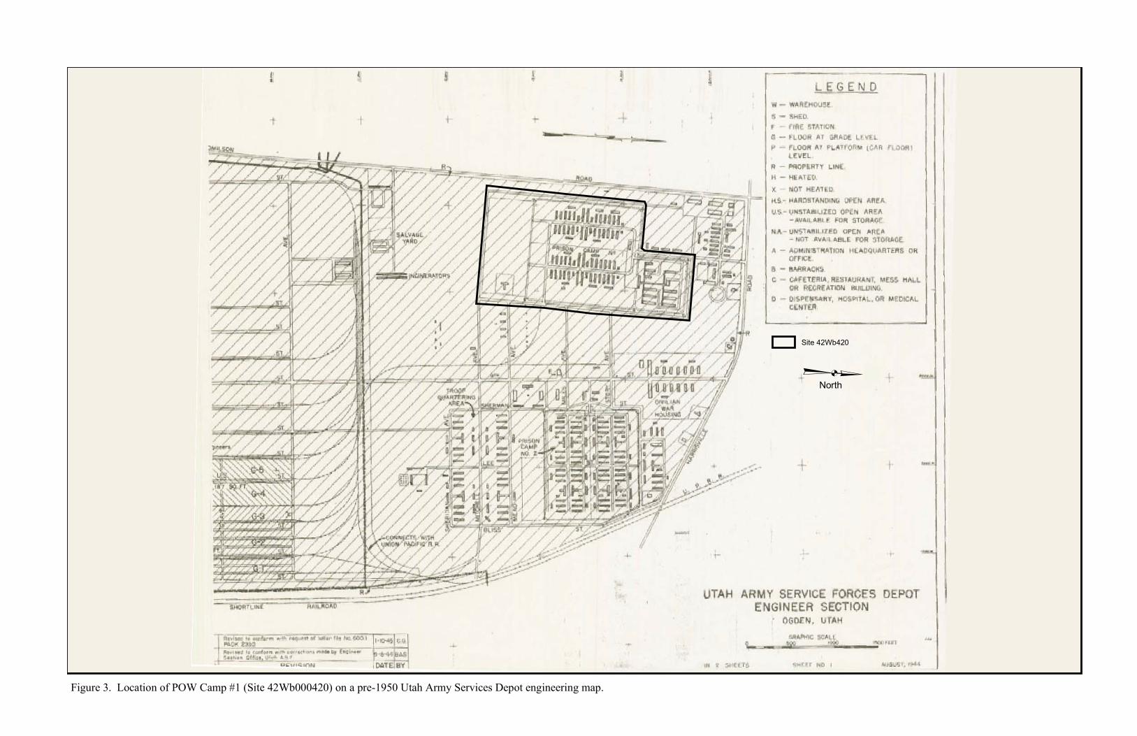
Site 42Wb420³North
Figure 3. Location of POW Camp #1 (Site 42Wb000420) on a pre-1950 Utah Army Services Depot engineering map.

}}
}}
} } } } } } } } }}
}
} } }
}}
}}
}}
}}
}}
}}
}}}}}}}}}}}}}}}
}
}
}
} }}
}}
}}
}
} } }
}}
}}
}}
}}
}}
}}
}}
}}
!U
!U
$+$+
!>!>
!>
!>
!>·h!>
’4
’4
’4’4
!>
!>
!>
!>
!>
!U
!U
’4
!>
!>
!>
!>
!>
!>
!>
!>
!>
!>
Bill Raiely Road
1200
We s
t
POVParking
USAREquipment
Yard
F-4
F-4
F-6
F-6
F-6
F-6
1
2
3 4 5 6
7
5756
55
54
52 53
122
121
120
118
117
116
114
113
111
110
F-9
123
119
115
112
109
F-3F-2
F-8
F-7
F-10
F-11
F-1
F-4
F-12
F-4
F-4
F-12
F-4
Proposed Trench Line (test excavation)
Building
Foundation
Site Boundary
’4 Culvert
·h Depression
!U Hydrant
!> Power Pole
$+ Sign
Bladed Road} Concrete Fence
DitchRoadPaved Road
} Modern Fence0 200 400 600
Feet
ÕTN MN
14°
Proj: 7352-087Date: 10-28-2004Source:ddo_trench
42Wb000420
Figure 4. Locations of proposed trench lines for excavations at POW Camp #1 (Site 42Wb000420).
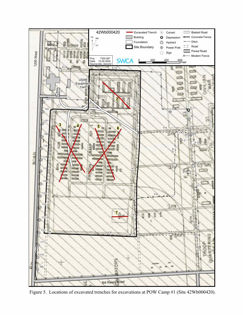
}}
}}
} } } } } } } } }}
}
} } }
}}
}}
}}
}}
}}
}}
}}}}}}}}}}}}}}}
}
}
}
} }}
}}
}}
}
} } }
}}
}}
}}
}}
}}
}}
}}
}}
!U
!U
$+$+
!>!>
!>
!>
!>·h!>
’4
’4
’4’4
!>
!>
!>
!>
!>
!U
!U
’4
!>
!>
!>
!>
!>
!>
!>
!>
!>
!>
Bill Raiely Road
1200
We s
t
POVParking
USAREquipment
Yard
F-4
F-4
F-6
F-6
F-6
F-6
2
3 4 5 6
7
5756
55
54
52 53
122
121
120
118
117
116
114
113
111
110
F-9
123
119
115
112
109
F-3F-2
F-8
F-7
F-10
F-11
F-1
F-4
F-12
F-4
F-4
F-12
F-4
Excavated Trench
Building
Foundation
Site Boundary
’4 Culvert
·h Depression
!U Hydrant
!> Power Pole
$+ Sign
Bladed Road} Concrete Fence
Ditch
RoadPaved Road
} Modern Fence0 200 400 600
Feet
ÕTN MN
14°
Proj: 7352-087Date: 10-28-2004Source:ddo_trench2
42Wb000420
Figure 5. Locations of excavated trenches for excavations at POW Camp #1 (Site 42Wb000420).
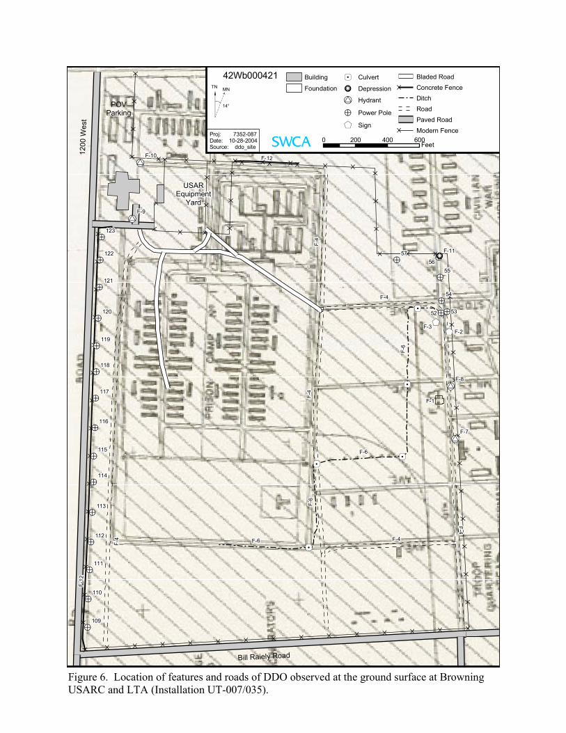
}}
}}
} } } } } } } } }}
}
} } }
}}
}}
}}
}}
}}
}}
}}}}}}}}}}}}}}}
}
}
}
} }}
}}
}}
}
} } }
}}
}}
}}
}}
}}
}}
}}
}}
!U
!U
$+$+
!>!>
!>
!>
!>·h!>
’4
’4
’4’4
!>
!>
!>
!>
!>
!U
!U
’4
!>
!>
!>
!>
!>
!>
!>
!>
!>
!>
Bill Raiely Road
1200
We s
t
POVParking
USAREquipment
Yard
F-4
F-4
F-6
F-6
F-6
F-6
5756
55
54
52 53
122
121
120
118
117
116
114
113
111
110
F-9
123
119
115
112
109
F-3F-2
F-8
F-7
F-10
F-11
F-1
F-4
F-12
F-4
F-4
F-12
F-4
Building
Foundation’4 Culvert
·h Depression
!U Hydrant
!> Power Pole
$+ Sign
Bladed Road} Concrete Fence
DitchRoadPaved Road
} Modern Fence0 200 400 600
Feet
ÕTN MN
14°
Proj: 7352-087Date: 10-28-2004Source: ddo_site
42Wb000421
Figure 6. Location of features and roads of DDO observed at the ground surface at BrowningUSARC and LTA (Installation UT-007/035).
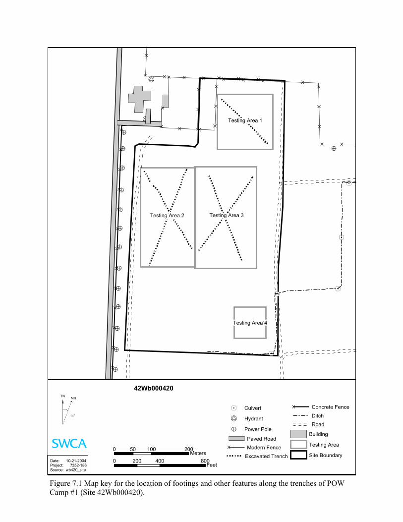
!>
’4
’4
’4’4
!>
!>
!>
!>
!U
!U
’4
!>
!>
!>
!>
!>
!>
!>
!>
!>
} } }
}}
}}
}}
}}
}}
}}
}
}}
} } } } } } } } }}
}
} }
}
}
}
} }
}}
}
}}
}
Testing Area 3Testing Area 2
Testing Area 1
Testing Area 4
42Wb000420
Date: 10-21-2004Project: 7352-186Source: wb420_site
0 100 20050Meters
0 400 800200Feet
’4 Culvert
!U Hydrant
!> Power Pole
Paved Road} Modern Fence
Excavated Trench
} Concrete Fence
DitchRoad
Building
Testing Area
Site Boundary
ÕTN MN
14°
Figure 7.1 Map key for the location of footings and other features along the trenches of POWCamp #1 (Site 42Wb000420).
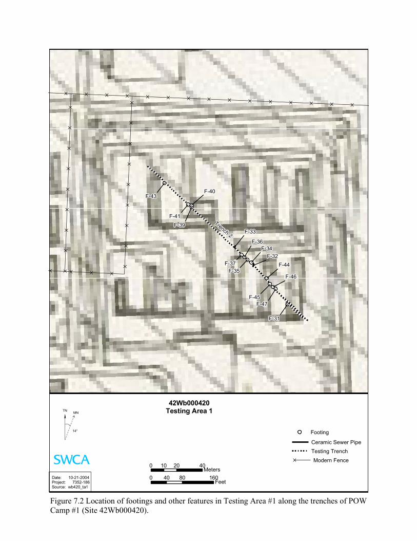
} } } } } } } } } } } } } } }
} } } }
}}
}}
}}
}}
}
}}
}}
}}
}}
}
Trench 2 F-33
F-32
F-47
F-46
F-45
F-44
F-43
F-41
F-40
F-39
F-37
F-36
F-35
F-34
F-31
42Wb000420Testing Area 1
Date: 10-21-2004Project: 7352-186Source: wb420_ta1
0 20 4010Meters
0 80 16040Feet
Footing
Ceramic Sewer PipeTesting Trench
} Modern Fence
ÕTN MN
14°
Figure 7.2 Location of footings and other features in Testing Area #1 along the trenches of POWCamp #1 (Site 42Wb000420).
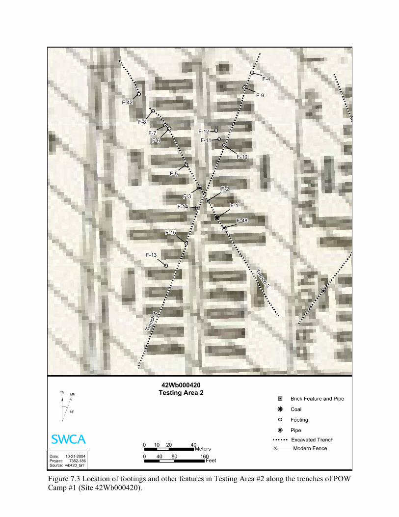
!P
h
"J
!P
"J
!P
Trench 3
Tren
ch 4
F-42
F-48
F-9
F-8
F-7F-6
F-5
F-3
F-4
F-2
F-1
F-15
F-14
F-13
F-12
F-11
F-10
42Wb000420Testing Area 2
Date: 10-21-2004Project: 7352-186Source: wb420_ta1
0 20 4010Meters
0 80 16040Feet
"J Brick Feature and Pipe
h Coal
Footing
!P Pipe
Excavated Trench} Modern Fence
ÕTN MN
14°
Figure 7.3 Location of footings and other features in Testing Area #2 along the trenches of POWCamp #1 (Site 42Wb000420).
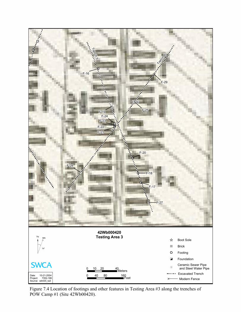
")
")
!.
[_
Trench 5
Tren
ch 6
F-29
F-28
F-27
F-26
F-25
F-24F-23
F-22
F-21
F-20
F-19
F-18
F-17
F-16
42Wb000420Testing Area 3
Date: 10-21-2004Project: 7352-186Source: wb420_ta3
0 20 4010Meters
0 80 16040Feet
[_ Boot Sole
") Brick
Footing
ÍÒ Foundation
!.Ceramic Sewer Pipe and Steel Water Pipe
Excavated Trench} Modern Fence
ÕTN MN
14°
Figure 7.4 Location of footings and other features in Testing Area #3 along the trenches ofPOW Camp #1 (Site 42Wb00420).
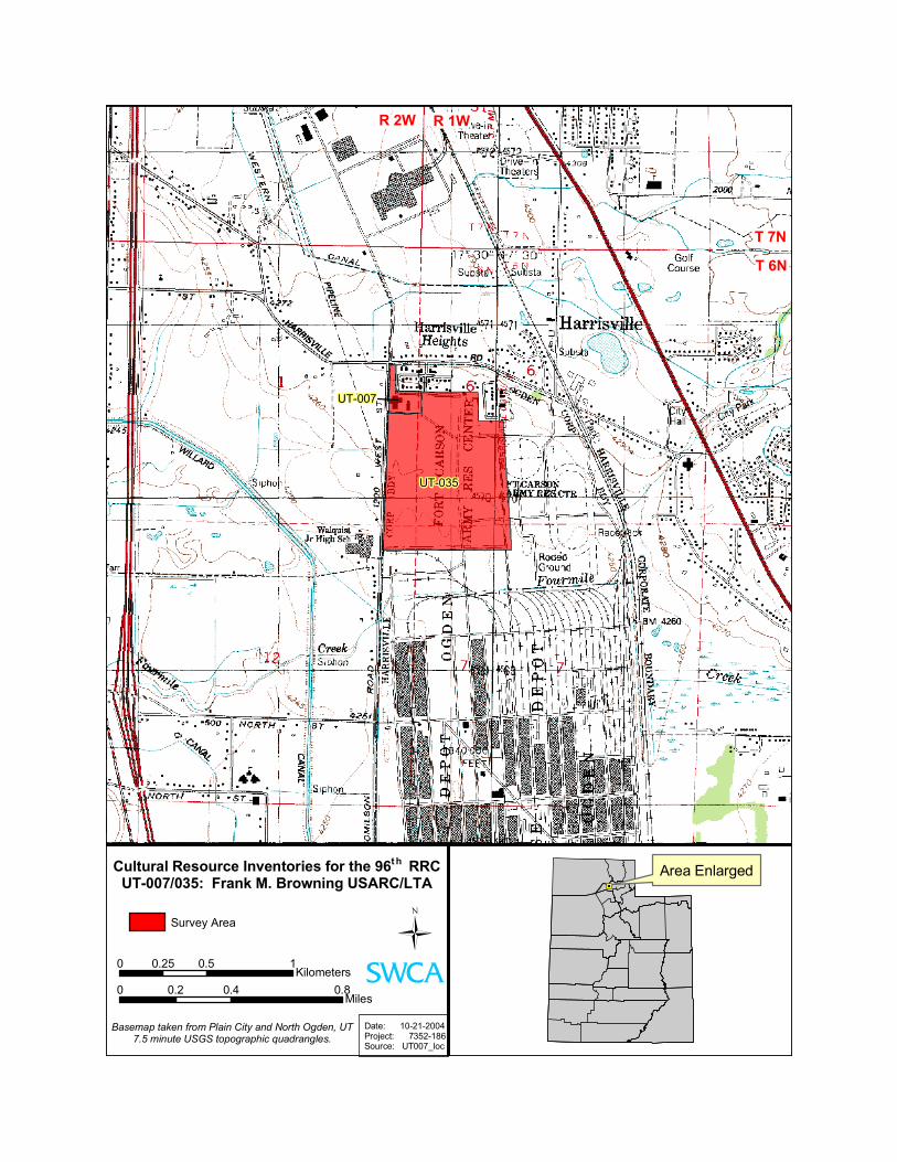
UT-007
UT-035
Cultural Resource Inventories for the 96t h RRCUT-007/035: Frank M. Browning USARC/LTA
Basemap taken from Plain City and North Ogden, UT7.5 minute USGS topographic quadrangles.
Date: 10-21-2004Project: 7352-186Source: UT007_loc
0 0.5 10.25Kilometers
0 0.4 0.80.2Miles
Survey Area
R 1WR 2W
T 7N
Area Enlarged
T 6N
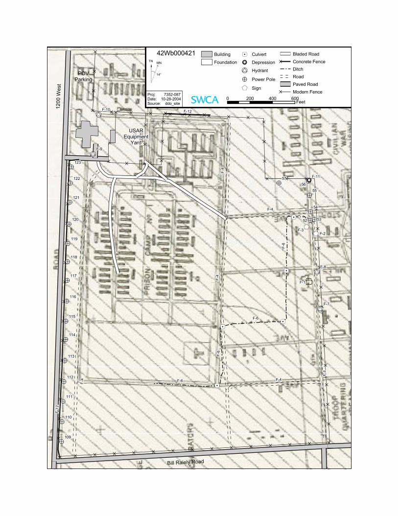
}}
}}
} } } } } } } } }}
}
} } }
}}
}}
}}
}}
}}
}}
}}}}}}}}}}}}}}}
}
}
}
} }}
}}
}}
}
} } }
}}
}}
}}
}}
}}
}}
}}
}}
!U
!U
$+$+
!>!>
!>
!>
!>·h!>
’4
’4
’4’4
!>
!>
!>
!>
!>
!U
!U
’4
!>
!>
!>
!>
!>
!>
!>
!>
!>
!>
Bill Raiely Road
1200
We s
t
POVParking
USAREquipment
Yard
F-4
F-4
F-6
F-6
F-6
F-6
5756
55
54
52 53
122
121
120
118
117
116
114
113
111
110
F-9
123
119
115
112
109
F-3F-2
F-8
F-7
F-10
F-11
F-1
F-4
F-12
F-4
F-4
F-12
F-4
Building
Foundation’4 Culvert
·h Depression
!U Hydrant
!> Power Pole
$+ Sign
Bladed Road} Concrete Fence
DitchRoadPaved Road
} Modern Fence0 200 400 600
Feet
ÕTN MN
14°
Proj: 7352-087Date: 10-28-2004Source: ddo_site
42Wb000421
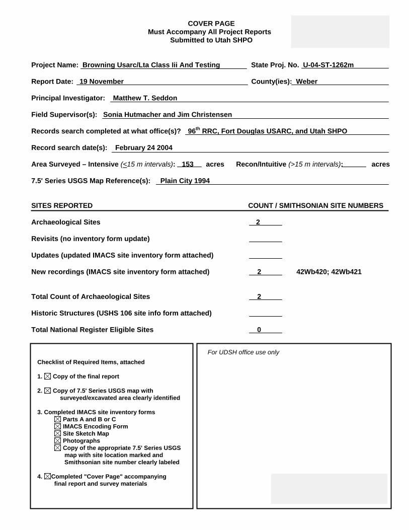
COVER PAGE Must Accompany All Project Reports
Submitted to Utah SHPO
Project Name: Browning Usarc/Lta Class Iii And Testing State Proj. No. U-04-ST-1262m Report Date: 19 November County(ies): Weber Principal Investigator: Matthew T. Seddon Field Supervisor(s): Sonia Hutmacher and Jim Christensen Records search completed at what office(s)? 96th RRC, Fort Douglas USARC, and Utah SHPO Record search date(s): February 24 2004 Area Surveyed – Intensive (<15 m intervals): 153 acres Recon/Intuitive (>15 m intervals): acres 7.5' Series USGS Map Reference(s): Plain City 1994 SITES REPORTED COUNT / SMITHSONIAN SITE NUMBERS Archaeological Sites 2 Revisits (no inventory form update) Updates (updated IMACS site inventory form attached) New recordings (IMACS site inventory form attached) 2 42Wb420; 42Wb421
Total Count of Archaeological Sites 2 Historic Structures (USHS 106 site info form attached) Total National Register Eligible Sites 0
Checklist of Required Items, attached 1. Copy of the final report 2. Copy of 7.5' Series USGS map with
surveyed/excavated area clearly identified 3. Completed IMACS site inventory forms
Parts A and B or C IMACS Encoding Form Site Sketch Map Photographs Copy of the appropriate 7.5' Series USGS
map with site location marked and Smithsonian site number clearly labeled
4. Completed "Cover Page" accompanying final report and survey materials
For UDSH office use only