Lead Concentration Analysis of Quadrangles 16, 20 and 24 ...
39o30'75o22'30"25'CANTON27'30"75o30'32'30"35'39o30'
TAYLORS BRIDGE
39o37'30" 35' 32'30"WILMINGTON SOUTH 75o30' 27'30" PENNS GROVE 25' 75o22'30"39o37'30"
35'
ALL
OW
AY
32'30"
B'
A'
Geology mapped 2006-2007.Cartography by S. Stanford and M. Girard.
B
Base from U. S. Geological Survey Salem (1948, photorevised 1986) and Delaware City (1993) quadrangles. Corner ticks for Salem are on North American Datum of 1927; corner ticks for Delaware City are on North American Datum of 1983. A gap of base information occurs along the boundary of the quadrangles.
Research supported by the U. S. Geological Survey, National Cooperative Geologic Mapping Program, under USGS award number 06HQAG0047. The views and conclusions contained in this document are those of the authors and should not be interpreted as necessarily representing the official policies, either expressed or implied, of the U. S. Government.
7000 FEET1000 10000 2000 3000 4000 5000 6000
.5 1 KILOMETER1 0
SCALE 1:24 0001/ 21 0 1 MILE
MA
GN
ETIC
NO
RTH
APPROXIMATE MEANDECLINATION, 1993
TRU
E N
OR
TH
�
LOCATION IN NEW JERSEY
11.5O
CONTOUR INTERVAL 10 FEET (SALEM QUADRANGLE), 5 FEET (DELAWARE CITY QUADRANGLE)
NATIONAL GEODETIC VERTICAL DATUM OF 1929
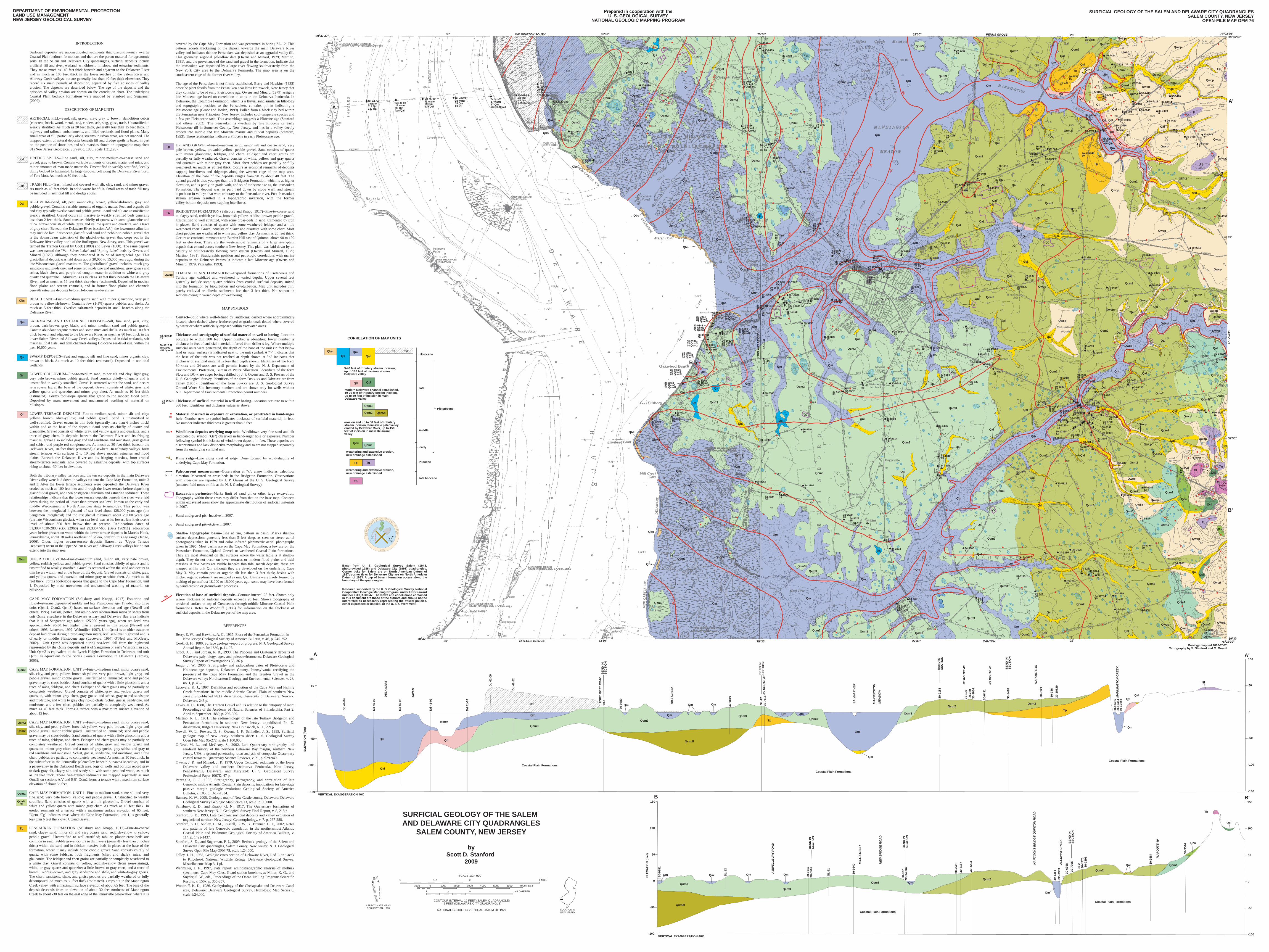
SURFICIAL GEOLOGY OF THE SALEM AND DELAWARE CITY QUADRANGLES
SALEM COUNTY, NEW JERSEY
byScott D. Stanford
2009
DEPARTMENT OF ENVIRONMENTAL PROTECTIONLAND USE MANAGEMENTNEW JERSEY GEOLOGICAL SURVEY
Prepared in cooperation with theU. S. GEOLOGICAL SURVEY
NATIONAL GEOLOGIC MAPPING PROGRAM
SURFICIAL GEOLOGY OF THE SALEM AND DELAWARE CITY QUADRANGLESSALEM COUNTY, NEW JERSEY
OPEN-FILE MAP OFM 76
INTRODUCTION
Surficial deposits are unconsolidated sediments that discontinuously overlie Coastal Plain bedrock formations and that are the parent material for agronomic soils. In the Salem and Delaware City quadrangles, surficial deposits include artificial fill and river, wetland, windblown, hillslope, and estuarine sediments. They are as much as 140 feet thick beneath and adjacent to the Delaware River and as much as 100 feet thick in the lower reaches of the Salem River and Alloway Creek valleys, but are generally less than 40 feet thick elsewhere. They record six main periods of deposition, separated by five episodes of valley erosion. The deposits are described below. The age of the deposits and the episodes of valley erosion are shown on the correlation chart. The underlying Coastal Plain bedrock formations were mapped by Stanford and Sugarman (2009).
DESCRIPTION OF MAP UNITS
ARTIFICIAL FILL--Sand, silt, gravel, clay; gray to brown; demolition debris (concrete, brick, wood, metal, etc.), cinders, ash, slag, glass, trash. Unstratified to weakly stratified. As much as 20 feet thick, generally less than 15 feet thick. In highway and railroad embankments, and filled wetlands and flood plains. Many small areas of fill, particularly along streams in urban areas, are not mapped. The mapped extent of natural deposits beneath fill and dredge spoils is based in part on the position of shorelines and salt marshes shown on topographic map sheet 81 (New Jersey Geological Survey, c. 1880, scale 1:21,120).
DREDGE SPOILS--Fine sand, silt, clay, minor medium-to-coarse sand and gravel; gray to brown. Contain variable amounts of organic matter and mica, and minor amounts of man-made materials. Unstratified to weakly stratified, locally thinly bedded to laminated. In large disposal cell along the Delaware River north of Fort Mott. As much as 50 feet thick.
TRASH FILL--Trash mixed and covered with silt, clay, sand, and minor gravel. As much as 40 feet thick. In solid-waste landfills. Small areas of trash fill may be included in artificial fill and dredge spoils.
ALLUVIUM--Sand, silt, peat, minor clay; brown, yellowish-brown, gray; and pebble gravel. Contains variable amounts of organic matter. Peat and organic silt and clay typically overlie sand and pebble gravel. Sand and silt are unstratified to weakly stratified. Gravel occurs in massive to weakly stratified beds generally less than 2 feet thick. Sand consists chiefly of quartz with some glauconite and mica. Gravel consists of white, gray, and yellow quartz and quartzite, and a trace of gray chert. Beneath the Delaware River (section AA'), the lowermost alluvium may include late Pleistocene glaciofluvial sand and pebble-to-cobble gravel that is the downstream extension of the glaciofluvial gravel that crops out in the Delaware River valley north of the Burlington, New Jersey, area. This gravel was termed the Trenton Gravel by Cook (1880) and Lewis (1880). The same deposit was later named the “Van Sciver Lake” and “Spring Lake” beds by Owens and Minard (1979), although they considered it to be of interglacial age. This glaciofluvial deposit was laid down about 20,000 to 15,000 years ago, during the late Wisconsinan glacial maximum. The glaciofluvial gravel includes much gray sandstone and mudstone, and some red sandstone and mudstone, gray gneiss and schist, black chert, and purple-red conglomerate, in addition to white and gray quartz and quartzite. Alluvium is as much as 30 feet thick beneath the Delaware River, and as much as 15 feet thick elsewhere (estimated). Deposited in modern flood plains and stream channels, and in former flood plains and channels beneath estuarine deposits before Holocene sea-level rise.
BEACH SAND--Fine-to-medium quartz sand with minor glauconite, very pale brown to yellowish-brown. Contains few (1-5%) quartz pebbles and shells. As much as 5 feet thick. Overlies salt-marsh deposits in small beaches along the Delaware River.
SALT-MARSH AND ESTUARINE DEPOSITS--Silt, fine sand, peat, clay; brown, dark-brown, gray, black; and minor medium sand and pebble gravel. Contain abundant organic matter and some mica and shells. As much as 100 feet thick beneath and adjacent to the Delaware River; as much as 80 feet thick in the lower Salem River and Alloway Creek valleys. Deposited in tidal wetlands, salt marshes, tidal flats, and tidal channels during Holocene sea-level rise, within the past 10,000 years.
SWAMP DEPOSITS--Peat and organic silt and fine sand, minor organic clay; brown to black. As much as 10 feet thick (estimated). Deposited in non-tidal wetlands.
LOWER COLLUVIUM--Fine-to-medium sand, minor silt and clay; light gray, very pale brown; minor pebble gravel. Sand consists chiefly of quartz and is unstratified to weakly stratified. Gravel is scattered within the sand, and occurs as a sparse lag at the base of the deposit. Gravel consists of white, gray, and yellow quartz and quartzite, and minor gray chert. As much as 10 feet thick (estimated). Forms foot-slope aprons that grade to the modern flood plain. Deposited by mass movement and unchanneled washing of material on hillslopes.
LOWER TERRACE DEPOSITS--Fine-to-medium sand, minor silt and clay; yellow, brown, olive-yellow; and pebble gravel. Sand is unstratified to well-stratified. Gravel occurs in thin beds (generally less than 6 inches thick) within and at the base of the deposit. Sand consists chiefly of quartz and glauconite. Gravel consists of white, gray, and yellow quartz and quartzite, and a trace of gray chert. In deposits beneath the Delaware River and its fringing marshes, gravel also includes gray and red sandstone and mudstone, gray gneiss and schist, and purple-red conglomerate. As much as 30 feet thick beneath the Delaware River, 10 feet thick (estimated) elsewhere. In tributary valleys, form stream terraces with surfaces 2 to 10 feet above modern estuaries and flood plains. Beneath the Delaware River and its fringing marshes, form eroded stream-terrace remnants, now covered by estuarine deposits, with top surfaces rising to about -30 feet in elevation.
Both the tributary-valley terraces and the terrace deposits in the main Delaware River valley were laid down in valleys cut into the Cape May Formation, units 2 and 3. After the lower terrace sediments were deposited, the Delaware River eroded as much as 100 feet into and through the lower terrace before depositing glaciofluvial gravel, and then postglacial alluvium and estuarine sediment. These relationships indicate that the lower terrace deposits beneath the river were laid down during the period of lower-than-present sea level known as the early and middle Wisconsinan in North American stage terminology. This period was between the interglacial highstand of sea level about 125,000 years ago (the Sangamon interglacial) and the last glacial maximum about 20,000 years ago (the late Wisconsinan glacial), when sea level was at its lowest late Pleistocene level of about 350 feet below that at present. Radiocarbon dates of 31,380+4530-2880 (GX 22966) and 29,330+/-600 (Beta 190911) radiocarbon years before present on wood within the lower terrace deposits in Marcus Hook, Pennsylvania, about 18 miles northeast of Salem, confirm this age range (Jengo, 2006). Older, higher stream-terrace deposits (known as "Upper Terrace Deposits") occur in the upper Salem River and Alloway Creek valleys but do not extend into the map area.
UPPER COLLUVIUM--Fine-to-medium sand, minor silt, very pale brown, yellow, reddish-yellow; and pebble gravel. Sand consists chiefly of quartz and is unstratified to weakly stratified. Gravel is scattered within the sand and occurs as thin layers within, and at the base of, the deposit. Gravel consists of white, gray, and yellow quartz and quartzite and minor gray to white chert. As much as 10 feet thick. Forms foot-slope aprons that grade to the Cape May Formation, unit 1. Deposited by mass movement and unchanneled washing of material on hillslopes.
CAPE MAY FORMATION (Salisbury and Knapp, 1917)--Estuarine and fluvial-estuarine deposits of middle and late Pleistocene age. Divided into three units (Qcm1, Qcm2, Qcm3) based on surface elevation and age (Newell and others, 1995). Fossils, pollen, and amino-acid racemization ratios in shells from unit Qcm2 elsewhere in the Delaware estuary and Delaware Bay area indicate that it is of Sangamon age (about 125,000 years ago), when sea level was approximately 20-30 feet higher than at present in this region (Newell and others, 1995; Lacovara, 1997; Wehmiller, 1997). Unit Qcm1 is an older estuarine deposit laid down during a pre-Sangamon interglacial sea-level highstand and is of early or middle Pleistocene age (Lacovara, 1997; O’Neal and McGeary, 2002). Unit Qcm3 was deposited during sea-level fall from the highstand represented by the Qcm2 deposits and is of Sangamon or early Wisconsinan age. Unit Qcm2 is equivalent to the Lynch Heights Formation in Delaware and unit Qcm3 is equivalent to the Scotts Corners Formation in Delaware (Ramsey, 2005).
CAPE MAY FORMATION, UNIT 3--Fine-to-medium sand, minor coarse sand, silt, clay, and peat; yellow, brownish-yellow, very pale brown, light gray; and pebble gravel, minor cobble gravel. Unstratified to laminated; sand and pebble gravel may be cross-bedded. Sand consists of quartz with a little glauconite and a trace of mica, feldspar, and chert. Feldspar and chert grains may be partially or completely weathered. Gravel consists of white, gray, and yellow quartz and quartzite, with minor gray chert, gray gneiss and schist, gray to red sandstone and mudstone, and white to gray clay rip-up clasts. Schist, gneiss, sandstone, and mudstone, and a few chert, pebbles are partially to completely weathered. As much as 40 feet thick. Forms a terrace with a maximum surface elevation of about 15 feet.
CAPE MAY FORMATION, UNIT 2--Fine-to-medium sand, minor coarse sand, silt, clay, and peat; yellow, brownish-yellow, very pale brown, light gray; and pebble gravel, minor cobble gravel. Unstratified to laminated; sand and pebble gravel may be cross-bedded. Sand consists of quartz with a little glauconite and a trace of mica, feldspar, and chert. Feldspar and chert grains may be partially or completely weathered. Gravel consists of white, gray, and yellow quartz and quartzite; minor gray chert; and a trace of gray gneiss, gray schist, and gray to red sandstone and mudstone. Schist, gneiss, sandstone, and mudstone, and a few chert, pebbles are partially to completely weathered. As much as 50 feet thick. In the subsurface in the Pennsville paleovalley beneath Supawna Meadows, and in a paleovalley in the Oakwood Beach area, logs of wells and borings record gray to dark-gray silt, clayey silt, and sandy silt, with some peat and wood, as much as 70 feet thick. These fine-grained sediments are mapped separately as unit Qmc2l on sections AA' and BB'. Qcm2 forms a terrace with a maximum surface elevation of about 35 feet.
CAPE MAY FORMATION, UNIT 1--Fine-to-medium sand, some silt and very fine sand; very pale brown, yellow; and pebble gravel. Unstratified to weakly stratified. Sand consists of quartz with a little glauconite. Gravel consists of white and yellow quartz with minor gray chert. As much as 15 feet thick. In eroded remnants of a terrace with a maximum surface elevation of 65 feet. "Qcm1/Tg" indicates areas where the Cape May Formation, unit 1, is generally less than 6 feet thick over Upland Gravel.
PENSAUKEN FORMATION (Salisbury and Knapp, 1917)--Fine-to-coarse sand, clayey sand, minor silt and very coarse sand; reddish-yellow to yellow; pebble gravel. Unstratified to well-stratified; tabular, planar cross-beds are common in sand. Pebble gravel occurs in thin layers (generally less than 3 inches thick) within the sand and in thicker, massive beds in places at the base of the formation, where it may include some cobble gravel. Sand consists chiefly of quartz with some feldspar, rock fragments (chert and shale), mica, and glauconite. The feldspar and chert grains are partially or completely weathered to a white clay. Gravel consists of yellow, reddish-yellow (from iron-staining), white, or gray quartz and quartzite; a little brown to gray chert; and a trace of brown, reddish-brown, and gray sandstone and shale, and white-to-gray gneiss. The chert, sandstone, shale, and gneiss pebbles are partially weathered or fully decomposed. As much as 30 feet thick (estimated). Crops out in the Mannington Creek valley, with a maximum surface elevation of about 65 feet. The base of the deposit descends from an elevation of about 30 feet northeast of Mannington Creek to about -30 feet on the east edge of the Pennsville paleovalley, where it is
covered by the Cape May Formation and was penetrated in boring SL-12. This pattern records thickening of the deposit towards the main Delaware River valley and indicates that the Pensauken was deposited as an aggraded valley fill. This geometry, regional paleoflow data (Owens and Minard, 1979; Martino, 1981), and the provenance of the sand and gravel in the formation, indicate that the Pensauken was deposited by a large river flowing southwesterly from the New York City area to the Delmarva Peninsula. The map area is on the southeastern edge of the former river valley.
The age of the Pensauken is not firmly established. Berry and Hawkins (1935) describe plant fossils from the Pensauken near New Brunswick, New Jersey that they consider to be of early Pleistocene age. Owens and Minard (1979) assign a late Miocene age based on correlation to units in the Delmarva Peninsula. In Delaware, the Columbia Formation, which is a fluvial sand similar in lithology and topographic position to the Pensauken, contains pollen indicating a Pleistocene age (Groot and Jordan, 1999). Pollen from a black clay bed within the Pensauken near Princeton, New Jersey, includes cool-temperate species and a few pre-Pleistocene taxa. This assemblage suggests a Pliocene age (Stanford and others, 2002). The Pensauken is overlain by late Pliocene or early Pleistocene till in Somerset County, New Jersey, and lies in a valley deeply eroded into middle and late Miocene marine and fluvial deposits (Stanford, 1993). These relationships indicate a Pliocene to early Pleistocene age.
UPLAND GRAVEL--Fine-to-medium sand, minor silt and coarse sand, very pale brown, yellow, brownish-yellow; pebble gravel. Sand consists of quartz with minor glauconite, feldspar, and chert. Feldspar and chert grains are partially or fully weathered. Gravel consists of white, yellow, and gray quartz and quartzite with minor gray chert. Most chert pebbles are partially or fully weathered. As much as 20 feet thick. Occurs as erosional remnants of deposits capping interfluves and ridgetops along the western edge of the map area. Elevation of the base of the deposits ranges from 90 to about 40 feet. The upland gravel is thus younger than the Bridgeton Formation, which is at higher elevation, and is partly on grade with, and so of the same age as, the Pensauken Formation. The deposit was, in part, laid down by slope wash and stream deposition in valleys that were tributary to the Pensauken river. Post-Pensauken stream erosion resulted in a topographic inversion, with the former valley-bottom deposits now capping interfluves.
BRIDGETON FORMATION (Salisbury and Knapp, 1917)--Fine-to-coarse sand to clayey sand, reddish-yellow, brownish-yellow, reddish-brown; pebble gravel. Unstratified to well stratified, with some cross-beds in sand. Cemented by iron in places. Sand consists of quartz with some weathered feldspar and a little weathered chert. Gravel consists of quartz and quartzite with some chert. Most chert pebbles are weathered to white and yellow clay. As much as 20 feet thick. Occurs as erosional remnants atop Burden Hill east of Quinton, above 90 to 120 feet in elevation. These are the westernmost remnants of a large river-plain deposit that extend across southern New Jersey. This plain was laid down by an easterly to southeasterly flowing river system (Owens and Minard, 1979; Martino, 1981). Stratigraphic position and petrologic correlations with marine deposits in the Delmarva Peninsula indicate a late Miocene age (Owens and Minard, 1979; Pazzaglia, 1993).
COASTAL PLAIN FORMATIONS--Exposed formations of Cretaceous and Tertiary age, oxidized and weathered to varied depths. Upper several feet generally include some quartz pebbles from eroded surficial deposits, mixed into the formation by bioturbation and cryoturbation. Map unit includes thin, patchy colluvial or alluvial sediments less than 3 feet thick. Not shown on sections owing to varied depth of weathering.
MAP SYMBOLS
Contact--Solid where well-defined by landforms; dashed where approximately located; short-dashed where featheredged or gradational; dotted where covered by water or where artificially exposed within excavated areas.
Thickness and stratigraphy of surficial material in well or boring--Location accurate to within 200 feet. Upper number is identifier; lower number is thickness in feet of surficial material, inferred from driller’s log. Where multiple surficial units were penetrated, the depth of the base of the unit (in feet below land or water surface) is indicated next to the unit symbol. A ">" indicates that the base of the unit was not reached at depth shown. A "<" indicates that thickness of surficial material is less than depth shown. Identifiers of the form 30-xxxx and 34-xxxx are well permits issued by the N. J. Department of Environmental Protection, Bureau of Water Allocation. Identifiers of the form SL-x and DC-x are auger borings drilled by J. P. Owens and D. S. Powars of the U. S. Geological Survey. Identifiers of the form Dcxx-xx and Ddxx-xx are from Talley (1985). Identifiers of the form 33-xxx are U. S. Geological Survey Ground Water Site Inventory numbers and are shown only for wells without N.J. Department of Environmental Protection permit numbers.
Thickness of surficial material in well or boring--Location accurate to within 500 feet. Identifiers and thickness values as above.
Material observed in exposure or excavation, or penetrated in hand-auger hole--Number next to symbol indicates thickness of surficial material, in feet. No number indicates thickness is greater than 5 feet.
Windblown deposits overlying map unit--Windblown very fine sand and silt (indicated by symbol "Qe") observed in hand-auger hole or exposure. Number following symbol is thickness of windblown deposit, in feet. These deposits are discontinuous and lack distinctive morphology and so are not mapped separately from the underlying surficial unit.
Dune ridge--Line along crest of ridge. Dune formed by wind-shaping of underlying Cape May Formation.
Paleocurrent measurement--Observation at "x", arrow indicates paleoflow direction. Measured on cross-beds in the Bridgeton Formation. Observations with cross-bar are reported by J. P. Owens of the U. S. Geological Survey (undated field notes on file at the N. J. Geological Survey). Excavation perimeter--Marks limit of sand pit or other large excavation. Topography within these areas may differ from that on the base map. Contacts within excavated areas show the approximate distribution of surficial materials in 2007.
Sand and gravel pit--Inactive in 2007.
Sand and gravel pit--Active in 2007.
Shallow topographic basin--Line at rim, pattern in basin. Marks shallow surface depressions generally less than 5 feet deep, as seen on stereo aerial photographs taken in 1979 and color infrared planimetric aerial photographs taken in 1995. Most basins are on the Cape May Formation, a few are on the Pensauken Formation, Upland Gravel, or weathered Coastal Plain formations. They are most abundant on flat surfaces where the water table is at shallow depth. They do not occur on lower terraces or modern flood plains and tidal marshes. A few basins are visible beneath thin tidal marsh deposits; these are mapped within unit Qm although they are developed on the underlying Cape May 3. May contain peat or organic silt less than 3 feet thick; basins with thicker organic sediment are mapped as unit Qs. Basins were likely formed by melting of permafrost 18,000 to 15,000 years ago; some may have been formed by wind erosion or groundwater processes.
Elevation of base of surficial deposits--Contour interval 25 feet. Shown only where thickness of surficial deposits exceeds 20 feet. Shows topography of erosional surface at top of Cretaceous through middle Miocene Coastal Plain formations. Refer to Woodruff (1986) for information on the thickness of surficial deposits in the Delaware part of the map area.
REFERENCES
Berry, E. W., and Hawkins, A. C., 1935, Flora of the Pensauken Formation in New Jersey: Geological Society of America Bulletin, v. 46, p. 245-252.
Cook, G. H., 1880, Surface geology--report of progress: N. J. Geological Survey Annual Report for 1880, p. 14-97.
Groot, J. J., and Jordan, R. R., 1999, The Pliocene and Quaternary deposits of Delaware: palynology, ages, and paleoenvironments: Delaware Geological Survey Report of Investigations 58, 36 p.
Jengo, J. W., 2006, Stratigraphy and radiocarbon dates of Pleistocene and Holocene-age deposits, Delaware County, Pennsylvania--rectifying the presence of the Cape May Formation and the Trenton Gravel in the Delaware valley: Northeastern Geology and Environmental Sciences, v. 28, no. 1, p. 45-76.
Lacovara, K. J., 1997, Definition and evolution of the Cape May and Fishing Creek formations in the middle Atlantic Coastal Plain of southern New Jersey: unpublished Ph.D. dissertation, University of Delaware, Newark, Delaware, 245 p.
Lewis, H. C., 1880, The Trenton Gravel and its relation to the antiquity of man: Proceedings of the Academy of Natural Sciences of Philadelphia, Part 2, April to September 1880, p. 296-309.
Martino, R. L., 1981, The sedimentology of the late Tertiary Bridgeton and Pensauken formations in southern New Jersey: unpublished Ph. D. dissertation, Rutgers University, New Brunswick, N. J., 299 p.
Newell, W. L., Powars, D. S., Owens, J. P., Schindler, J. S., 1995, Surficial geologic map of New Jersey: southern sheet: U. S. Geological Survey Open File Map 95-272, scale 1:100,000.
O’Neal, M. L., and McGeary, S., 2002, Late Quaternary stratigraphy and sea-level history of the northern Delaware Bay margin, southern New Jersey, USA: a ground-penetrating radar analysis of composite Quaternary coastal terraces: Quaternary Science Reviews, v. 21, p. 929-940.
Owens, J. P., and Minard, J. P., 1979, Upper Cenozoic sediments of the lower Delaware valley and northern Delmarva Peninsula, New Jersey, Pennsylvania, Delaware, and Maryland: U. S. Geological Survey Professional Paper 1067D, 47 p.
Pazzaglia, F. J., 1993, Stratigraphy, petrography, and correlation of late Cenozoic middle Atlantic Coastal Plain deposits: implications for late-stage passive margin geologic evolution: Geological Society of America Bulletin, v. 105, p. 1617-1634.
Ramsey, K. W., 2005, Geologic map of New Castle county, Delaware: Delaware Geological Survey Geologic Map Series 13, scale 1:100,000.
Salisbury, R. D., and Knapp, G. N., 1917, The Quaternary formations of southern New Jersey: N. J. Geological Survey Final Report, v. 8, 218 p.
Stanford, S. D., 1993, Late Cenozoic surficial deposits and valley evolution of unglaciated northern New Jersey: Geomorphology, v. 7, p. 267-288.
Stanford, S. D., Ashley, G. M., Russell, E. W. B., Brenner, G. J., 2002, Rates and patterns of late Cenozoic denudation in the northernmost Atlantic Coastal Plain and Piedmont: Geological Society of America Bulletin, v. 114, p. 1422-1437.
Stanford, S. D., and Sugarman, P. J., 2009, Bedrock geology of the Salem and Delaware City quadrangles, Salem County, New Jersey: N. J. Geological Survey Open File Map OFM 75, scale 1:24,000.
Talley, J. H., 1985, Geologic cross-section of Delaware River, Red Lion Creek to Kilcohook National Wildlife Refuge: Delaware Geological Survey, Miscellaneous Map 3, 1 pl.
Wehmiller, J. F., 1997, Data report: aminostratigraphic analysis of mollusk specimens: Cape May Coast Guard station borehole, in Miller, K. G., and Snyder, S. W., eds., Proceedings of the Ocean Drilling Program: Scientific Results, v. 150x, p. 355-357.
Woodruff, K. D., 1986, Geohydrology of the Chesapeake and Delaware Canal area, Delaware: Delaware Geological Survey, Hydrologic Map Series 6, scale 1:24,000.
afd
aft
Qal
Qm
Qs
Qcl
Qtl
Qcu
Qcm3
Qcm2
Qcm2l
Qcm1
Qcm1/Tg
Tp
Tg
Tb
Qwcp
!
!
.
!
-25
!
!
4
Qe3
30-806515
34-364130
D
xx
30-981640 Qcm3>53 Qcm2l
Qbs
QmQal
aft
5-40 feet of tributary stream incision;up to 100 feet of incision in main Delaware valley
Qtl
modern Delaware channel established,10-20 feet of tributary stream incision,up to 50 feet of incision in main Delaware valley
Qcu
Qcm2
Qcm1
weathering and extensive erosion,new drainage established
Tp
CORRELATION OF MAP UNITS
Pliocene
early
middle
late
Holocene
Pleistocene
Qcl
Qcm3
erosion and up to 50 feet of tributary stream incision, Pennsville paleovalley eroded by Delaware River, up to 150 feet of incision in main Delaware valley
Qsafd
Qcm2l
weathering and extensive erosion,new drainage established
Tb
Tg
late Miocene
Qbs
Qe2
.
.
.
.
.
.
.
..
..
.
.
.
.
.
.
.
.
.
.
.
.
..
.
.
.
.
.
.
.
.
.
.
.
.
.
.
.
..
.
.
.
.
.
.
.
.
!
!!
!
! !
!! !
!
!
!
!
!
!
!
!!
!!
!
!!!
!!
!
!
!!
!
!
!
!
! !
!
!
!
!
!!
!!!
!
!!!
!
!
!
!
!
!
!
!
! !!
!
!!!
!!!
!!!!
!! !
!!
!!
!
!
!
!
!
!
!
!
!
!
! !
!
!
!!!
!
!
!
!
!
!
!
!
!
!!!
!
!
!
!
!
!
!
!
!
!
!!
!
!
!
!
!!
!
!
!
!
!
!
!
!
!! !
!
!
!
!
!
!
!
!
!
!
!
!! !
!
!
!
!
!
!
!
!
!
!
!
!
!
!
! !
!
!
!
!
!
!
!
!
!
!
!
!!
!!
!
!
!
!
!
!
!
!
!
!
!
!
!
!
!
!
!
!
!
!
!
!
!!
!
!
!
!
!
!
!
!
!
!
!
!
!
!
!
!
!
!
!
!
!
!
!
!
!
!
!
!
!
!
!
!
!
!
!
!!
!
!
!
!
!
!
!
!
!
!
!
!
!
!
!
!
!
!
!
!
!
!
!
!
!
!
!
!
!
!
!
!
!!
!
!!
!
!
!
!
!
!! !
!
!!
!
!
!!
!!
!
!
!
!
!
!
!
!
!!
!
!
!
!
!
!
!
!
!
!!
!
!
!
!
!
!
!
!
!
!
!
!
!
!
!
!
!
!
!
!
!
!
!
!
!
!
!
!
!
!
!
!!
!
!
!
!
!
!
!!
!
!
!!
!
!
!
!
!
!
!
!
!
!
!
!
!
!
!
!
!
!
!
!
!
!
!
!
!
!
!
!
!
!
!
!
!
!
!
!
!
!
!
!
!
!
!
!
!
!
!
!
!
!
!
!
!
!
!
!
!
!
!
!
!
!
!
!
!
!
!
!
!!
!
!
!
!
!!
!
!
!
!
!
!
!
!
!
!
!
!
!
!!
!
!
!
!!
!
!
!
!
!
!
!
!
!
!
!
!
!
!!
!
!
!
!
!
!
!
!
!
!
!
!
!
!
!!
!
!
!
!!
!
!
!
! !
!
ADc 44-043 water112 Qm142 Qal
Dc 45-0212 water95 Qm128 Qal
Dc 45-0511 water99 Qm115 Qal
Dd 41-0328 water35 Qm60 Qtl
Dd 41-0717 water27 Qm76 Qtl-Qcm3
Dd 41-0931 afd47 Qm>75 Qcm3
Dd 42-0229 afd41 Qm>75 Qcm3
30-1490428
30-111143
afdafd
-100
-75
-50
-25
-25
-50
-75
-100
-100
-75
Qm
Qm
Qm
Qbs
Qcm3
Qs
DC-146
Qcm3
30-9480>30
Qbs
Qm
Qcm3
Qcm3Qcm3
Qcm3
30-52, 33-10838
Qcm3
Qcm3Qcm3
Qm
Qal
Qal
Qcm3
30-981640 Qcm3>53 Qcm2l
30-204941 Qcm372 Qcm2l
30-433124
30-843930
30-720920
30-935316
30-711645SL-12
11 Qcm336 Tp
30-802730
-50
-25
-25
-50
PENN
SVIL
LE
PALE
OVA
LLEY
Qcm3
Qcm3
Qm
Qcm3
Qcm3
Qm
Qm
Qcm3
Qcm3
Qm
30-235925
30-653130
30-429537
Qm
-75
-75
-50
-25
-50
-25
Qcm2
Qal Qal
Qal
Qm
Qcm2
Qcm2
Qal
QalQal
Tp
Qtl
Qm
Qal
Qal
Tp
Tp
Qal
Qal
Qm
Qm
Qtl
Qtl
Qtl
Tp
Qcm2Qcm2 Qal
30-912124
30-1082935
30-75233
30-563130
30-78640
30-141832
30-94232
30-649127
30-742811
30-74244
30-742511
30-763815
30-2287
Qwcp
30-5838
30-74266
30-74276
30-74170
30-74180
30-54160
30-64110
30-74690
30-50450
30-78180
30-7040
Qcm1
Qwcp
Qwcp
Qal
QalQcm2
Qcm2
Qcm2
Qcm2
Qwcp
Qe2
Qe2
Qwcp
Tg
Tg
Qwcp
30-74200
30-74430
30-74380
30-74390
30-74220
Tg
QtlQwcp
Qwcp30-47480
Qe2
Qcm2
Qal
Qal
Qtl
Qcm2
Qwcp
Tp
Qal30-525930
30-100660
30-104554 fill>25 Qm
30-104545 fill45 Qm
30-104525 fill39 Qm
30-276221
Qtl
Qal
Qal
0-25
0
0
-25
-25
0
0
-25
-25
Qcm2
Qbs
Qbs
Qcm3
Qcm3
Qcm3
Qm
Qcm3
Qs30-847612 fill27 Qm>60 Qcm3-Qcm2
30-709210
30-55>25
30-570524
33-10625
30-509810 fill25 Qm
30-337785 Qm
Qcm3
Qm-25
-50
-75
-75-50
-25
30-150113
30-73511
30-103612
30-115317
30-991528Qe2
Qm
Qcm2
QalQal
Qm
Qm
Qal
30-19530
30-22017
30-906419
30-127920
30-1105240
0
-25
-25
Qtl
QalQal
Qcm2
Qal
Qal
SL-714
Qal
QalQcm2
30-99160
30-46920
30-46080
Qwcp
Qm
Qm
Qm
Qm
Qbs
Qs
Qs
Qm
Qcm3
Qm
Qm
Qcm3
Qm
Qal
Qcm3
-100
-75
-50-25
30-796431 Qcm372 Qcm2l
30-934635 Qcm377 Qcm2l
30-367660
30-793733 Qcm374 Qcm2l
30-799425 Qcm381 Qcm2l
30-541425 Qcm365 Qcm2l
30-585633 Qcm375 Qcm2l
30-1022028 Qcm380 Qcm2l30-8121
35 Qcm395 Qcm2l
30-985122 Qcm390 Qcm2l
30-1022542 Qcm388 Qcm2l
30-333035 Qcm375 Qcm2l
30-814837 Qcm3108 Qcm2l
30-256545
SL-13>21
30-980950 Qm
30-1045839
30-975017
30-82317
30-3660>52 Qm
30-664530
30-635625 30-7807
12
30-1069920
30-794314
30-1028629
30-1063417
30-806515
30-460614
30-818912
SL-1119
30-65672630-6047
38
Qe4
Qe2
Qe2
Qe4
Qe2
Qe2
Qe3
Qe4Qe2 Qe2
30-964023
SL-96 30-1044
31
30-87721
30-1486727
30-82225
30-82123
30-558832
Qm
Qm
Qcm3
Qal
Qal
30-768685 Qm30-7927
66 Qm
30-103292 fill13 Qm30-10312
7 fill18 Qm
30-1032516
30-1032710 fill20 Qm
30-335728
30-461612
30-1066435
30-420331
30-818746
30-752536
30-13240
30-254930
30-530532
Qcm2
Qcm3
Qm
Qal
Qal
Qal
Qal
Qal
Qal
Qwcp
Qwcp
SL-103
30-161012
30-98267
30-42399
Qe2
Qe24
45
30-94059
30-56654
30-86458
30-343130
30-176330
30-9482930-878627
Qcm2
Qcm2
Qcm2
Qcm2
Qcm1
Qm
Qm
Qtl
Qal
Qal
Qal
Qal
Qal
Qal
Qal
Qcm2
Qal
Qwcp
Qwcp
Qwcp
Qwcp
QwcpQwcp
7
5
Qe2
Qe4
30-958425
34-354410
30-85634 30-10471
1130-594715
Qcm1/Tg
Tg
TbTg
Qcl
Qwcp
Qwcp
Qwcp
Qwcp
Qwcp
Qal
Qal
Qwcp
Qcm2
Qcm2
Qcm2
Qwcp
Qwcp
Qal
Qal
Qal
Qal
Qwcp
Qwcp
Qcm2 Qcm1
Qcu
Tb
Tb
QclQwcp
30-604913
30-52640
30-2820
34-8170
Qcm1
Qal
Qcm2
Qm
Qal
Qal
Qal
30-53126
30-86898
30-608417
30-536515
30-70018
30-164628
34-320530
SL-1626
30-1039812
30-823512
30-484114
30-30119
30-432715
30-677025
30-360027
30-182120
30-29619
30-239110
30-477018
30-218
30-30319
30-70618
30-17514
30-709517
30-636313 fill33 Qm
30-636110 fill26 Qm
30-638617
30-636410 fill35 Qm30-6387
33 30-636531
30-636814
30-1009121
Qal
Qal
Qal
Qcm2
Qcm3
Qcm3
Qcm3
Qal
Qal
Qal
Qm
30-345627
30-820827
30-291417
Qe2
Qe330-978430
SL-1424
34-37076
34-29093534-3641
30
30-836435
Qe4
Qe2
Qe2
QsQal
Qcm3Qm
Qbs
Qcm3
Qcm3
Qcm3
Qcm3Qbs
Qm
Qcm3
30-971714
30-71801530-3740
4 Qbs25 Qm
Qcm3
Qbs
Qcm3Qcm3
Qm
Qm
Qcm3Qcm3
Qcm3
Qm
Qm
Qe4
Qe4
Qe2
Qe2
Qe2
Qs
Qcm3
30-752931
34-374420
34-362935
34-312126
30-543332
34-313325
34-43540
34-21044 fill28 Qcm3
Qm
Qcm3
Qcm3
SL-174 fill21 Qcm3
34-360017
Qcm3
Qcm3
Qal
Qal34-347238
34-111317
34-97228
34-243130
34-323012
34-352511
Qm
Qcm2
Qcm2
Qal
Qal
Qal
QmQal
Qal
34-32516 34-3324
<35SL-158
34-3459834-47220
34-317515
34-345815 34-2680
15
Qal
34-239610
4
4
Qcm2
Qcm1
Qcm1
Qwcp
Tg
Qcu
QalQcl
Tg
Qwcp
QwcpQwcp Qcm2
Qal
Qcm1
Qwcp
34-38035
34-203719
D
D
-25
-25
-50
-75
-25
-75
-25
-50
-50
-25
-25
-25
0
0
0
0
-25
0
0
0
0
Qwcp
aft
aft
x
xx
Qal
Qcm2
Qe>5
Qe2
Qe3
Qe4
Qe5Qe3
Qe6Qe3
Qe4
30-91062 fill35 Qm
30-275510 fill>30 Qm
12
Qe2
DEL
AWA
RE
CIT
Y
SALE
M
-25
-25
Qal
30-764625
100
50
0
-50
-100
-150VERTICAL EXAGGERATION 40X
ELEV
ATIO
N (fe
et)
Qm
Qal
Qtl
water
Dc 4
4-04
Dc 4
5-02
Dc 4
5-05
Dd 4
1-02
Dd 4
1-07
DEL
AWA
RE
RIV
ER
A
afd
Qm
Qcm3
Coastal Plain Formations
Dd 4
1-09
Dd 4
2-02
BEND
INSE
CTIO
NDC
-1
30-9
480
MIL
L C
REE
K
FORT
MO
TT R
OA
D
Qcm3
Qcm2l
Qm
Qm
Qm Qm 30-9
816
Qcm3Tp
Qm Qm
Qm
Qcm3
Coastal Plain Formations
BEND
INSE
CTIO
NSL
-12
30-7
116
SALE
M R
IVER
MA
NN
ING
TON
MEA
DO
WNJ
RO
UTE
49
NJ
RO
UTE
45
NJ
RO
UTE
45
NJ
RO
UTE
45
BEND
INSE
CTIO
N
BEND
IN
SECT
ION
30-9
155
30-1
9530
-220
30-9
064
30-6
491
30-1
418
30-9
121
30-7
8630
-108
29
Qcm3
Qcm2Qcm2
Coastal Plain Formations
Tp
Qm
QtlQal
Tg
30-1
0485
30-1
0454
30-1
0455
MA
NN
ING
TON
CR
EEK
100
50
0
A'
-50
-100
-150
Qal
150
100
50
0
-50
-100VERTICAL EXAGGERATION 40X
ELEV
ATIO
N (fe
et)
30-9
851
Qm
Qcm3
Qcm2l
Qm SL-1
3
30-6
047
30-6
567
SL-1
1
BEND
INSE
CTIO
N
AM
WEL
LBU
RY R
OA
D
Qm Qm
Qcm3
Coastal Plain Formations
30-9
640
Qcm3
30-8
7730
-14,
867
BEND
INSE
CTIO
N
MIL
L ST
REE
T
NEW
BR
IDG
E R
OA
DQm
30-7
525
30-8
187
30-4
203
Qcm2
HA
NC
OC
KS
BR
IDG
E-Q
UIN
TON
RO
AD
ALL
OW
AY C
REE
K BEND
INSE
CTIO
N
30-6
361
30-6
363
30-6
368
30-7
095
30-2
Qm
30-4
770
30-2
391
Qcm2
Qal
Coastal Plain Formations
30-9
584
NJ
RO
UTE
49
Qcm1
Qcu
34-3
544
Tb
Qcl
150
100
50
B'
0
-50
-100
B