Department for Transport - LTN 1/04 - Policy, Planning and ... 1-04 Policy, Planning and Design...
38
LTN 1/04 - Policy, Planning and Design for Walking and Cycling Table of contents 1. Introduction 1.1 Context 2. Policy 2.1 Walking, cycling and integrated transport 2.2 Walking, cycling, health and the environment 2.3 Walking, cycling and road safety 2.4 Strategies for encouraging walking and cycling 2.5 Monitoring and re-evaluation 3. Planning and Design principles 3.1 Introduction 3.2 Design requirements 3.3 Hierarchy of users 3.4 The design pedestrian and design cyclist 3.5 Route function and journey purpose 3.6 Hierarchies of provision 3.7 Cycling infrastructure for different traffic speeds and volumes 3.8 Infrastructure planning 3.9 Audit and review 3.10 Land use planning 3.11 Consultation and publicity 4. Applying The Design Options 4.1 Introduction 4.2 Traffic reduction 4.3 Speed reduction 4.4 Reallocation of road space to pedestrians 4.5 Provision of at-grade crossings for pedestrians 4.6 Improved pedestrian routes on existing desire lines 4.7 New pedestrian-only alignment or grade separation 4.8 Complementary and trip-end facilities for pedestrians - 1 - Department for Transport - LTN 1/04 - Policy, Planning and Design for Walking and Cycling
Transcript of Department for Transport - LTN 1/04 - Policy, Planning and ... 1-04 Policy, Planning and Design...

LTN 1/04 - Policy, Planning and Design for Walking and Cycling
Table of contents1. Introduction 1.1 Context 2. Policy 2.1 Walking, cycling and integrated transport 2.2 Walking, cycling, health and the environment 2.3 Walking, cycling and road safety 2.4 Strategies for encouraging walking and cycling 2.5 Monitoring and re-evaluation 3. Planning and Design principles 3.1 Introduction 3.2 Design requirements 3.3 Hierarchy of users 3.4 The design pedestrian and design cyclist 3.5 Route function and journey purpose 3.6 Hierarchies of provision 3.7 Cycling infrastructure for different traffic speeds and volumes 3.8 Infrastructure planning 3.9 Audit and review 3.10 Land use planning 3.11 Consultation and publicity 4. Applying The Design Options 4.1 Introduction 4.2 Traffic reduction 4.3 Speed reduction 4.4 Reallocation of road space to pedestrians 4.5 Provision of at-grade crossings for pedestrians 4.6 Improved pedestrian routes on existing desire lines 4.7 New pedestrian-only alignment or grade separation 4.8 Complementary and trip-end facilities for pedestrians
- 1 -
Department for Transport - LTN 1/04 - Policy, Planning and Design for Walking and Cycling

4.9 Junction treatment, hazard site treatment and traffic management for cyclists 4.10 Redistribution of the carriageway for cyclists 4.11 Cycle lanes 4.12 Cycle tracks 4.13 Complementary and trip-end facilities for cyclists 4.14 Temporary measures for pedestrians and cyclists 5. Key References and Useful Addresses 5.1 General 5.2 Walking 5.3 Cycling 5.4 Walking and cycling 5.5 Transport, health and environment 5.6 Road safety 5.7 Useful addresses Annex A
1. Introduction
1.1 Context
1.1.1 The Government’s policy for integrated transport has introduced a substantial change in theapproach to transport schemes. In promoting an integrated transport system, the Government recognisesthe necessity for improving conditions for pedestrians and cyclists, with particular emphasis on the needsof disabled people. Promotion of walking and cycling is important in helping to support other majorGovernment objectives such as improved public health, better air quality, and sustainable land-useplanning.
1.1.2 This Local Transport Note (LTN) applies to rights of way under the control of local highwayauthorities. Two other LTNs accompany it. LTN 2/04 Adjacent and Shared Use Facilities for Pedestriansand Cyclists provides updated guidance on the application and design of off-carriageway facilities forcyclists and pedestrians (supersedes LTN 2/86). LTN 3/04, Signs and Markings for Cycle Routes providesguidance to designers of cycling facilities on the use of Traffic Signs Regulations and General Directions, 2002 and it includes some common layouts (supersedes LTN 2/87).
1.1.3 All three LTNs refer to parts of the Design Manual for Roads and Bridges (DMRB). However, whilethe DMRB is a useful source of standards and advice for trunk roads, it is often not appropriate in thecontext of local roads. Local authorities should therefore consider how it is applied with care. Ultimately,local authorities are the arbiters of what happens on local roads. Guidance for accommodatingnon-motorised users along and across trunk roads is available from the Highways Agency.
1.1.4 Developments and innovations for walking and cycling are reported in Traffic Advisory Leaflets(TALs) available from the Department for Transport (DfT).
- 2 -
Department for Transport - LTN 1/04 - Policy, Planning and Design for Walking and Cycling
1.1.5 This document sets out the policy context that supports the promotion of pedestrian and cyclingfacilities(Chapter 2). It also describes common design principles for pedestrian and cycle provision(Chapter 3). These include:
an overarching principle that any new measures proposed for pedestrians and cyclists shouldrepresent a real improvement over the existing situation, particularly in terms of accessibility, and,where practical and appropriate, offer users a positive advantage over motor traffic; the role of land use planning in enabling users to undertake more journeys on foot or by cycling; a hierarchy of users, which can assist in prioritising the needs of different transport modes wherethere are conflicting demands on carriageway space, or there is incompatibility in the highwaylayouts suiting different modes; hierarchies of provision, which provide a systematic approach to determining the best engineeringsolution for pedestrians and cyclists at a particular site; minimum requirements which should be met if the infrastructure is to be Convenient, Accessible,Safe, Comfortable and Attractive for pedestrians and cyclists; the various needs of different "design cyclists" and "design pedestrians" which should be consideredwhen planning appropriate infrastructure; and the need for monitoring and evaluation to ensure that measures are fulfilling their intended purpose.
1.1.6 The decision-making framework for selecting and designing pedestrian and cycle infrastructurecovers network planning, cycle/pedestrian review, scheme selection, scheme design and audit, and schemeimplementation. The selection process uses the hierarchies of provision, and guides the designer toconsider traffic reduction and speed reduction as the first options, followed by various on-carriagewaysolutions for cyclists. Where routes follow existing roads, the designer should only consider newoff-carriageway options for cyclists or new alignments/grade-separated facilities for pedestrians if allon-carriageway solutions (including traffic and speed reduction) have been rejected as insufficient orinappropriate. However, this does not necessarily apply where the intention is to improve an existingoff-carriageway route or where there is a specific need for a new route away from the road. LTN 2/04gives guidance on the introduction of off-carriageway routes for cyclists.
1.1.7 Chapter 4 of this LTN outlines in more detail the infrastructure techniques available to cater forwalking and cycling, and provides references for further guidance on these techniques. Examples areprovided of how the policy and principles of the design process might be applied to promote walking andcycling.
2. Policy
2.1 Walking, cycling and integrated transport
2.1.1 The need to provide for pedestrians and cyclists is emphasised in the Government’s Guidance onFull Local Transport Plans and in Transport 2010 - The 10 Year Plan in which the delivery mechanismsfor the Transport White Paper are outlined. These documents emphasise the key role of walking andcycling as the main modes used for short trips (especially to local facilities such as shops, schools, etc)and in providing access to public transport for longer journeys.
- 3 -
Department for Transport - LTN 1/04 - Policy, Planning and Design for Walking and Cycling
2.1.2 The role of walking and cycling in helping to create liveable towns and cities and to promote healthimprovement and social inclusion has not always been recognised in the past. Around 25% of all journeys,and 80% of journeys of less than one mile are made on foot. Almost all other journeys include an elementof walking. Three in ten households in the UK do not have access to a car, and in many one carhouseholds the majority of trips are made by non-car modes. Ensuring that there is safe and convenientaccess to jobs, education, health care, other services, and local facilities for non-motorised road users is anessential part of promoting social inclusion. Walking and cycling are low-cost travel modes available toalmost all ages and have an important role to play.
2.1.3 The need to take the whole journey into account is important when considering public transport.Safe pedestrian and cycle access, and secure appropriate cycle parking (short and long term) atinterchange facilities can help to stimulate greater use of these modes in conjunction with public transport.Improved cycling facilities can significantly increase the catchment of public transport stops, helping toboost patronage on the services. Improved access to public transport is an important element in reducingsocial exclusion.
2.1.4 High quality design of townscapes and rural transport infrastructure can help to encourage walkingand cycling and assist with tackling social exclusion in many ways (see Towards an Urban Renaissance,DETR 1999, and Making the Connections - Transport and Social Exclusion, Social Exclusion Unit,ODPM 2003. Improvements to the walking and cycling environment are an inherent part of improvingpublic spaces in towns and cities, and of providing access to work, education and healthcare in urban andrural areas. The emphasis on mixed use in new developments should help to bring about an increase in thenumber of shorter journeys undertaken on foot or by bike, and create attractive environments forpedestrians and cyclists.
2.1.5 Promoting walking and cycling is an important part of the Government’s drive to raise the quality oflife through the creation of sustainable communities. These are well designed, liveable places that aresafe, visually attractive, and function well - places where people want to live and work. In order to realisehigh quality sustainable communities, the Government has placed good design at the heart of its planningpolicy. Policy Planning Guidance notes PPG1 and PPG3 make it clear that design is a materialconsideration of the planning system. PPG13 (Transport), promotes development patterns that encouragewalking and cycling. PPG6 (Town Centres) places a strong emphasis on attractive pedestrianenvironments, keeping locations of the various activities and uses within walking distance of each other.
2.2 Walking, cycling, health and the environment
2.2.1 Walking and cycling for utility trips provide the opportunity to undertake daily exercise without theneed for specialist equipment. Britain has a higher rate of coronary heart disease (CHD) and associatedillnesses than most European countries. A modest amount of regular moderate intensity exercise such aswalking or cycling can help to protect against developing such illnesses as CHD, stroke,non-insulin-dependent diabetes, osteoporosis and, by improving strength and co-ordination, it can alsoprotect against falls, fractures and injuries (Davis, A, Active Transport, HEA 1999). Non-exerciserscycling approximately 30km per week can make significant gains in fitness, sufficient to considerablyreduce any propensity to develop CHD (TAL 12/99, Cycling for Better Health).
- 4 -
Department for Transport - LTN 1/04 - Policy, Planning and Design for Walking and Cycling
2.2.2 Encouraging walking and cycling is included in the policy document Our Healthier Nation, DoH1999. Air pollution can be attributed as a contributory cause to many respiratory diseases. Walking andcycling for short trips can help to reduce emissions to meet the objectives of the Government’s AirQuality Strategy, DETR 2000.
2.2.3 The Government published the UK’s Climate Change Programme in 2000. The programme sets outhow the UK plans to meet its Kyoto target to cut greenhouse emissions to 12.5% below 1990 levels by2008-2012, and move towards its domestic goal to cut carbon dioxide emissions to 20% below 1990levels by 2010.
2.3 Walking, cycling and road safety
2.3.1 The Government has set the following casualty reduction targets for 2010 1 in its policy document Tomorrow’s Roads: Safer for Everyone, DETR 2000:
a 40% reduction in the number of people killed or seriously injured in road accidents; a 50% reduction in the number of children killed or seriously injured in road accidents; and a 10% reduction in the slight casualty rate, expressed as the number of people slightly injured per100 million vehicle kilometres.
2.3.2 Child casualty reduction is a special focus of the 2010 Road Safety Strategy, which acknowledgesthe need to improve Britain’s record, aligning it with the levels achieved in some other Europeancountries.
2.3.3 Government also wishes to encourage more walking and cycling to improve public health and theenvironment, and to reduce congestion. Encouraging more children to walk and cycle to school is a keyaim of the Government. This is demonstrated by its support, through the LTP process, for Safer routes toSchools and School Travel Plans.
2.3.4 Delivering increases in walking and cycling while reducing casualty numbers for these modes willrequire significant action by highway authorities, the police and others with responsibility for rights ofway. Chapter 4 of this LTN provides examples of appropriate infrastructure measures that will createenvironments where it is safer to walk and cycle. It should be noted that walking and/or cycling journeysmay take place along routes away from the highway network on footpaths, bridleways, canal towing pathsand other rights of way. It is important that user safety is fully considered in the design of such routes.
2.3.5 Excessive and inappropriate speed is by far the biggest single contributor to recorded casualties inBritain. It can also be a significant deterrent to walking and cycling by creating a perception of danger. New Directions in Speed Management, a Review of Policy, DETR 2000, recommends reviewing thefunction of roads, and specifically their importance for walking and cycling journeys, to assist in settingspeed limits.
2.4 Strategies for encouraging walking and cycling
2.4.1 During the last two decades, the number of walking journeys per person has fallen by 10% and theaverage distance walked by 24% (see Providing for Journeys on Foot, IHT 2000. The quality of thewalking environment has deteriorated in many places as a result of increased motor traffic, worsened
- 5 -
Department for Transport - LTN 1/04 - Policy, Planning and Design for Walking and Cycling

perceptions of crime and assault, and a reduction in environmental quality. Although some areas havewitnessed increases in cycle use since 1996, in many parts of the UK, cycling has remained at the baselevel of around 2% of all trips.
2.4.2 Local walking and cycling strategies set out how highway and planning authorities aim to encourageand facilitate the use of these modes. The inclusion of local walking and cycling strategies is arequirement in the guidance on preparing full Local Transport Plans. Successful strategies are often linkedto employer and school travel plans or to health promotion initiatives. Sources of guidance on developinglocal walking and cycling strategies are listed in the bibliography.
2.5 Monitoring and re-evaluation
2.5.1 Local authorities should monitor progress towards the targets set in their walking and cyclingstrategies, and they should periodically re-evaluate these strategies to ensure that they are using the mosteffective means to achieve the targets. Cycling strategies would usually be expected to contain targets formodal shift, since in most areas, the level of cycling is extremely low. Such an indicator may be lessrelevant to walking, particularly in inner-urban areas where a high proportion of journeys is alreadyundertaken on foot. TAL 2/00, Framework for a Local Walking Strategy, suggests key objectives,measures, outcomes and performance indicators, and gives advice on how to measure these. Manypractical examples are included in Walking: Making it Happen, London Walking Forum 2000. TheAnnual Progress Report of the Local Transport Plan should include an assessment of progress towards thetargets that a local authority hopes to achieve within the life of the plan.
2.5.2 Planning, monitoring and evaluation should involve studies of usage and demand to gain anunderstanding of which routes people use and why they use them. This will inform the development andimprovement process, and help in establishing the necessary maintenance procedures.
1 The baseline values for the 2010 casualty reduction targets are the average casualty rates for 1994-1998
3. Planning and Design principles
3.1 Introduction
3.1.1 Integrated transport plays an important part in realising the Government’s aims of creating welldesigned sustainable communities. This issue is less constrained by finance than it was in the past andshould lead to a greater range of infrastructure solutions to accommodate the conflicting demands ofdifferent modes in any given situation. Particular attention is drawn to the role of walking and cycling insupporting these aims.
3.1.2 This chapter describes the key concepts used in designing for pedestrians and cyclists. These includeminimum pedestrian and cyclist requirements, the design pedestrian and design cyclist, and thehierarchies of provision. Recommended processes for selecting appropriate infrastructure for pedestriansand cyclists are presented at Annex A in Figures 1 and 2 respectively.
- 6 -
Department for Transport - LTN 1/04 - Policy, Planning and Design for Walking and Cycling

3.1.3 With careful design and traffic management, it is sometimes possible to cater for the needs ofpedestrians and cyclists without providing obvious measures such as cycle lanes and sub-ways etc. Thisconcept is often referred to as "invisible infrastructure" and its importance should not be underestimated.
3.2 Design requirements
3.2.1 Planning and designing high quality infrastructure involves developing very localised solutions inclose consultation with local people, but there are some basic requirements that need to be satisfied, andthese are summarised below. The underlying principle is that measures for pedestrians and cyclists shouldoffer positive provision that reduces delay, diversion and danger. The design requirements should beconsidered in conjunction with the hierarchy of users (Section 3.3), hierarchies of provision (Section 3.6)and take into account the achievable traffic conditions (Section 3.7) to determine the most appropriatedesign solution.
3.2.2 Five core principles have been established common to both pedestrians and cyclists. They have beenderived from the requirements for pedestrians included in Guidelines for providing for journeys on foot,IHT 2000 (Connectivity, Conspicuity, Convenience, Comfort, and Conviviality) and the requirements forcyclists included in Cycle Friendly Infrastructure, IHT 1996 (Coherence, Directness, Comfort, Safety, andAttractiveness). They are:
3.2.3 Convenient: Networks should allow people to go where they want, and new facilities should usuallyoffer an advantage in terms of directness and/or reduced delay compared with existing provision. Routesand key destinations should be properly signed and street names should be clearly visible. On-street routemaps can be particularly helpful in certain locations. Published route maps should also be made available.Ideally, routes should be unimpeded by street furniture, pavement parking and other obstructions whichcan be particularly hazardous to visually impaired pedestrians. There should be the minimum practicabledelay for pedestrians and/or cyclists waiting at signalled crossings, and they should not face long detoursalong their route. Trip-end facilities should be clearly marked, conveniently located, and appropriate forthe likely length of stay. Designers should consider the future ease of maintenance, including access tovehicles for sweeping, trimming grass verges and making surface and lighting repairs along off-roadroutes.
3.2.4 Accessible: Pedestrian and cycling routes should form a network linking trip origins and keydestinations including public transport access points. The routes should be continuous and as direct aspossible in terms of distance and journey time (type and colour of surfacing can be used to stress routecontinuity as appropriate). There should be proper provision for crossing busy roads and other barriers inurban and rural areas, and in some areas there should be a positive advantage over private motorisedtraffic. As far as is practicable, all parts of each route (including crossing points) should be situated ondesire lines. Routes should be provided into and through areas normally inaccessible to motor vehiclessuch as parks and shopping centres, as this may help to encourage modal shift. Safe access for pedestriansand cyclists should be maintained at all times during road works. The needs of people with various typesand degrees of disability should be taken into account at the design stage by consulting local groupsrepresenting them.
3.2.5 Safe: Not only must infrastructure be safe, but for the well being of users, it must be perceived to besafe. Traffic volumes and speeds should be reduced where possible in order to create the desiredconditions. Reducing the impact of motor traffic also facilitates the implementation of other measures
- 7 -
Department for Transport - LTN 1/04 - Policy, Planning and Design for Walking and Cycling

beneficial to pedestrians and cyclists which might not otherwise be viable. Opportunities for redistributingspace within the highway should be fully explored including moving kerblines and street furniture,providing right-turn refuges for cyclists or separating conflicting movements by using traffic signals. Thepotential for conflict between pedestrians and cyclists should be minimised. Maintenance plays animportant part with regard to safe operation, and surface defects should not be allowed to develop to theextent that they become a hazard. Similarly, vegetation should be regularly cut back to preserve availablewidth and sight lines. The latter is particularly relevant with regard to crime and the fear of crime. Apartfrom long sight lines, the risk of crime can be reduced through the removal of hiding places along theroute, provision of lighting, and the presence of passive surveillance from neighbouring premises or otherusers. Waiting rooms, cycle parking etc, should be sited where people using the facilities can feel safe. Inrural areas, the needs of pedestrians, cyclists and equestrians should be considered where their routescross busy roads, and where a satellite village or district is separated from a town or city by a major ringroad or bypass.
3.2.6 Comfortable: Infrastructure should meet design standards for width, gradient, and surface qualityetc, and cater for all types of user, including children and disabled people as appropriate. Pedestrians andcyclists benefit from even, well-maintained and regularly swept surfaces with gentle gradients. Droppedkerbs are particularly beneficial to users of wheelchairs, pushchairs and cycles, and tactile paving needs tobe provided to assist visually impaired people. Dropped kerbs should be properly flush with the roadsurface. Even a very small step can be uncomfortable and irritating for some users, especially if there areseveral to be negotiated along a route. Seating at regular intervals is desirable to enable people to stop andrest. Comfort is enhanced when users are free from the fear of crime.
3.2.7 Attractive: Aesthetics, noise reduction and integration with surrounding areas are important. Thewalking and cycling environment should be attractive, interesting and free from litter, dog mess andbroken glass. If possible, routes should cater for users wishing to stop, chat and rest. The ability for peopleto window shop, walk or cycle two abreast, converse or stop to look at a view makes for a more pleasantenvironment. Public spaces need to be well-designed, finished in attractive materials, and be such thatpeople want to stop in them to spend some time there. The surfaces, landscaping and street furniture mustbe well-maintained and regularly cleaned, and in keeping with the surrounding area. Issues of lightpollution should be considered in addition to personal security in rural and semi-rural routes.
3.3 Hierarchy of users
3.3.1 The concept of a hierarchy of users has been established for use in the planning and design processesfor new developments and proposed traffic management schemes. This places pedestrians at the top,followed by cyclists then public transport, with unaccompanied private car-users last. The objective ofsuch a hierarchy is to ensure that the needs of the most vulnerable road users are fully considered in allhighway schemes, but not necessarily to give priority to pedestrians and cyclists in every location.
3.3.2 Adoption of a hierarchy of users is recommended as one of the elements of good practice in LocalTransport Plans, and is one of the recommendations in the Government’s Response to the SelectCommittee on Walking in Towns and Cities, DTLR 2001.
- 8 -
Department for Transport - LTN 1/04 - Policy, Planning and Design for Walking and Cycling

3.4 The design pedestrian and design cyclist
3.4.1 This is a useful concept to distinguish between the differing priorities assigned to various aspects ofa route (for example, safety versus directness) for users with different requirements due to their journeypurpose, level of experience or physical ability. The design of the most appropriate infrastructure needs totake account of the anticipated type of user.
3.4.2 The design pedestrian types are:
Commuter - prefers a fast direct route between home and work or when accessing public transport,regardless of quality of environment; Shopper/leisure walker - looks for ease of access, attractive retail environments, and attractiveroutes; Disabled person - requires level, clearly defined easy access and careful attention in the design andplacement of street furniture, including resting points. Satisfying these requirements will also satisfythe needs of all other users, especially older people, people with heavy shopping/young children, andpeople with temporary impairments or low levels of fitness; and Child - requires a high level of segregation from motorised traffic and/or other measures to reducethe dominance of motor vehicles, such as speed reduction, together with good passive surveillancefrom other users. These are important factors where children and young people make independentjourneys, especially journeys to school.
3.4.3 The design cyclist types are;
Fast commuter - confident in most on-road situations, and will use a route with significant trafficvolumes if it is more direct than a quieter route; Other utility cyclist - may seek some segregation at busy junctions and on links carrying high-speedtraffic; Inexperienced utility, commuter and leisure cyclist - may be willing to sacrifice directness in terms ofboth distance and time, for a route with less traffic and more places to stop and rest. May travel moreslowly than regular cyclists; Child - may require segregated, direct routes from residential areas to schools, even where anon-road solution is available. Design needs to take account of personal security issues. Child cyclistsshould be anticipated in all residential areas and on most leisure cycling routes; Users of specialised equipment - includes disabled people using hand-cranked machines and users oftrailers, trailer-cycles, tandems and tricycles. This group requires wide facilities free of sharp bendsand an absence of pinch-points or any other features which force cyclists to dismount. Cycle tracksand lanes where adult cyclists frequently accompany young children should be sufficiently wide toallow for cycling two abreast. This enables the adult to ride on the offside of the child whennecessary.
3.4.4 All types of pedestrian and cyclist will use high quality well maintained traffic-free routes awayfrom the carriageway if they are more direct than the equivalent on-road alternative and there are nopersonal security issues.
- 9 -
Department for Transport - LTN 1/04 - Policy, Planning and Design for Walking and Cycling
3.5 Route function and journey purpose
3.5.1 For most journeys, convenience (in terms of journey time and distance) and an acceptable degree oftraffic safety and personal security are the most important design requirements for pedestrians andcyclists. This is particularly the case for access to public transport interchanges or other time criticaljourneys. These should be the main factors to take into consideration when planning networks of routes.
3.5.2 The journey purpose is important in defining the value attached to attractiveness. There aresituations where walking or cycling for pleasure may be the only reason for the journey. These includerural leisure routes, parks, urban squares and tourist destinations. There are also multi-functionenvironments such as shopping arcades, market places and public transport interchanges where peoplemay wish to meet, relax or trade, but which may also serve as through-routes for pedestrians and cyclists.
3.5.3 Careful urban design can ensure that these areas are attractive and functional - it is important to getthe balance right. Guidance on how to deliver a high quality environment is set out in By Design, DETR2000. Advice on how to accommodate the conflicting requirements of multi-function urban roads andtown centres is contained in Transport and the Urban Environment IHT 1998. The design of good qualityurban pedestrian space is covered in Going to Town - Improving Town Centre Access - a companion guideto PPG6, DfT 2002, Designing Streets for People, ICE 2000, and Guidelines on Pedestrianised High Streets IHT 2001. Inclusive Mobility - A Guide to Best Practice on Access to Pedestrian and Transport Infrastructure, DfT 2002 sets out guidance on providing for access by disabled people to footways,footpaths, pedestrian areas, public transport and car parks. Guidelines and principles for good qualitydesign of residential areas are included in Places, Streets and Movement: A Companion Guide to DesignBulletin 32, Residential Roads and Footpaths, DETR 1998, and Better Places to Live, DTLR 2001.
3.5.4 In order to accommodate the differing and sometimes conflicting needs of various user types andfunctions, it may be necessary to combine measures or to create dual networks offering different levels ofprovision, with one network offering greater segregation from motor traffic at the expense of directnessand/or priority. Such dual networks may be considered analogous to a busy main road carryingthrough-traffic and a service road catering for access to homes and shops at lower speeds.
3.6 Hierarchies of provision
3.6.1 The majority of pedestrian or cycle routes use the existing road network. The first step in planningpedestrian or cycle infrastructure measures is to assess if any change is needed to existing provision. If so,selecting the appropriate measures should generally follow a preferred hierarchy for each mode (SeeTable 3.6). The hierarchy does not necessarily apply to schemes where it is intended to construct totallynew cycle tracks/footpaths to a high standard which offer a more advantageous route than the equivalentroute for motorised traffic. For pedestrians on narrow rural roads where speeds can be difficult to controland sightlines are often restricted, a new footway is often the preferred option.
Table 3.6: Hierarchies of provision
- 10 -
Department for Transport - LTN 1/04 - Policy, Planning and Design for Walking and Cycling
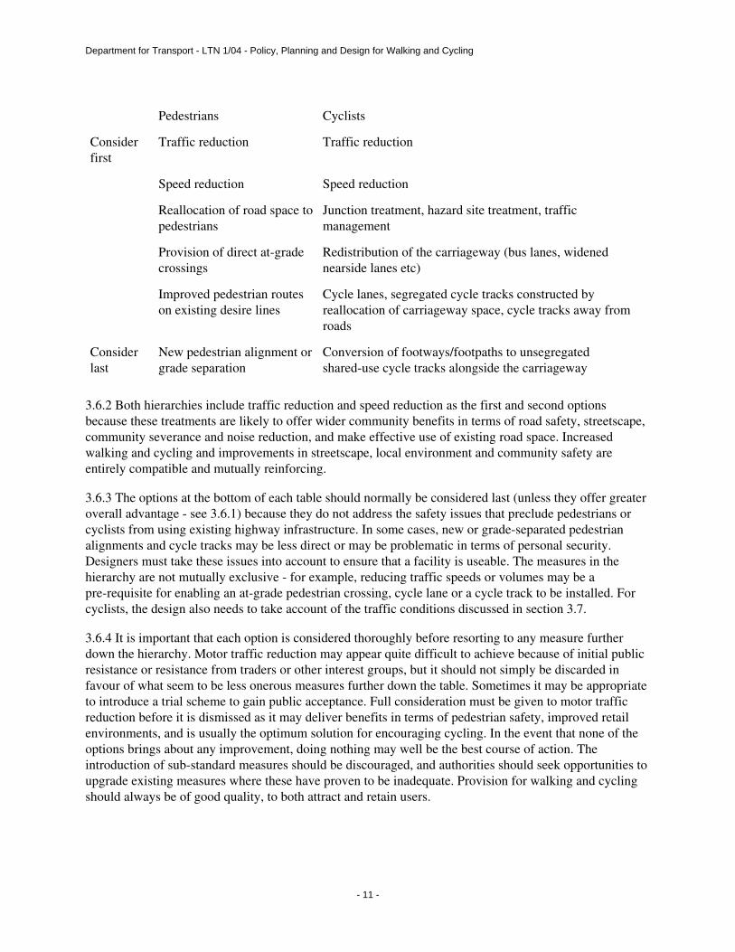
Pedestrians Cyclists
Considerfirst
Traffic reduction Traffic reduction
Speed reduction Speed reduction
Reallocation of road space topedestrians
Junction treatment, hazard site treatment, trafficmanagement
Provision of direct at-gradecrossings
Redistribution of the carriageway (bus lanes, widenednearside lanes etc)
Improved pedestrian routeson existing desire lines
Cycle lanes, segregated cycle tracks constructed byreallocation of carriageway space, cycle tracks away fromroads
Considerlast
New pedestrian alignment orgrade separation
Conversion of footways/footpaths to unsegregatedshared-use cycle tracks alongside the carriageway
3.6.2 Both hierarchies include traffic reduction and speed reduction as the first and second optionsbecause these treatments are likely to offer wider community benefits in terms of road safety, streetscape,community severance and noise reduction, and make effective use of existing road space. Increasedwalking and cycling and improvements in streetscape, local environment and community safety areentirely compatible and mutually reinforcing.
3.6.3 The options at the bottom of each table should normally be considered last (unless they offer greateroverall advantage - see 3.6.1) because they do not address the safety issues that preclude pedestrians orcyclists from using existing highway infrastructure. In some cases, new or grade-separated pedestrianalignments and cycle tracks may be less direct or may be problematic in terms of personal security.Designers must take these issues into account to ensure that a facility is useable. The measures in thehierarchy are not mutually exclusive - for example, reducing traffic speeds or volumes may be apre-requisite for enabling an at-grade pedestrian crossing, cycle lane or a cycle track to be installed. Forcyclists, the design also needs to take account of the traffic conditions discussed in section 3.7.
3.6.4 It is important that each option is considered thoroughly before resorting to any measure furtherdown the hierarchy. Motor traffic reduction may appear quite difficult to achieve because of initial publicresistance or resistance from traders or other interest groups, but it should not simply be discarded infavour of what seem to be less onerous measures further down the table. Sometimes it may be appropriateto introduce a trial scheme to gain public acceptance. Full consideration must be given to motor trafficreduction before it is dismissed as it may deliver benefits in terms of pedestrian safety, improved retailenvironments, and is usually the optimum solution for encouraging cycling. In the event that none of theoptions brings about any improvement, doing nothing may well be the best course of action. Theintroduction of sub-standard measures should be discouraged, and authorities should seek opportunities toupgrade existing measures where these have proven to be inadequate. Provision for walking and cyclingshould always be of good quality, to both attract and retain users.
- 11 -
Department for Transport - LTN 1/04 - Policy, Planning and Design for Walking and Cycling
3.6.5 Unsegregated shared-use by pedestrians and cyclists should normally be at the bottom of thehierarchy. The decision to adopt this option by taking space from pedestrians must not be taken lightly -see LTN 2/04.
3.7 Cycling infrastructure for different traffic speeds and volumes
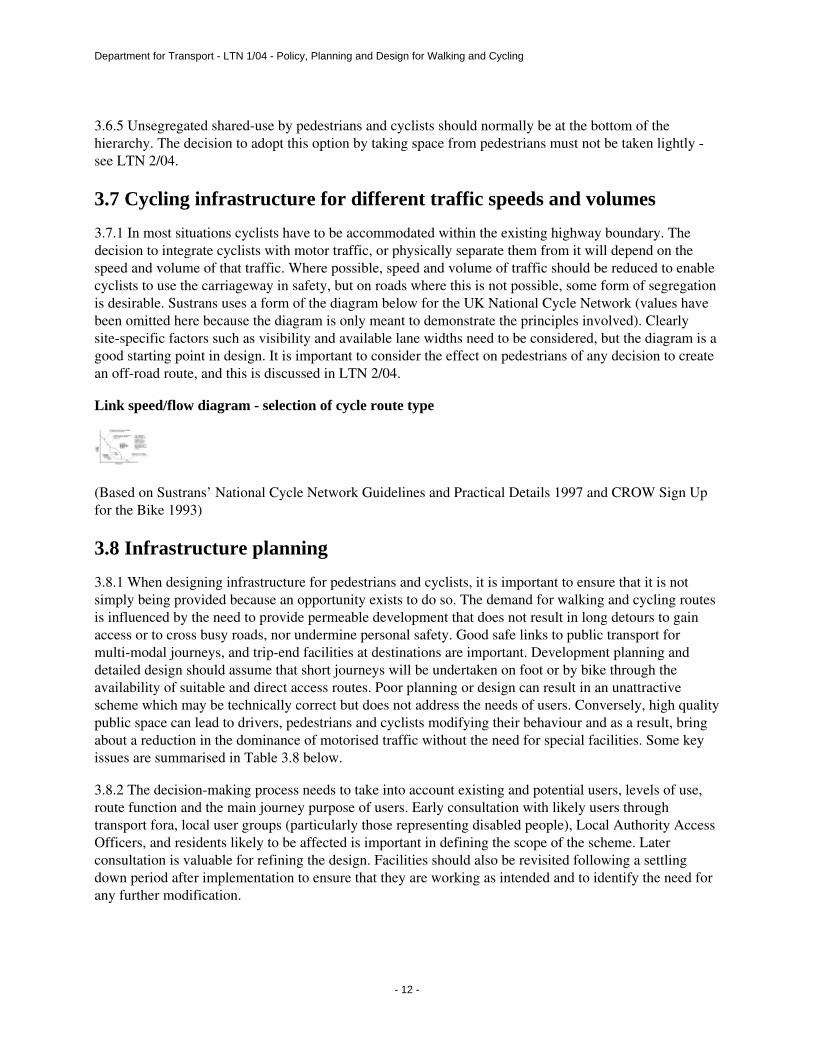
3.7.1 In most situations cyclists have to be accommodated within the existing highway boundary. Thedecision to integrate cyclists with motor traffic, or physically separate them from it will depend on thespeed and volume of that traffic. Where possible, speed and volume of traffic should be reduced to enablecyclists to use the carriageway in safety, but on roads where this is not possible, some form of segregationis desirable. Sustrans uses a form of the diagram below for the UK National Cycle Network (values havebeen omitted here because the diagram is only meant to demonstrate the principles involved). Clearlysite-specific factors such as visibility and available lane widths need to be considered, but the diagram is agood starting point in design. It is important to consider the effect on pedestrians of any decision to createan off-road route, and this is discussed in LTN 2/04.
Link speed/flow diagram - selection of cycle route type
(Based on Sustrans’ National Cycle Network Guidelines and Practical Details 1997 and CROW Sign Upfor the Bike 1993)
3.8 Infrastructure planning
3.8.1 When designing infrastructure for pedestrians and cyclists, it is important to ensure that it is notsimply being provided because an opportunity exists to do so. The demand for walking and cycling routesis influenced by the need to provide permeable development that does not result in long detours to gainaccess or to cross busy roads, nor undermine personal safety. Good safe links to public transport formulti-modal journeys, and trip-end facilities at destinations are important. Development planning anddetailed design should assume that short journeys will be undertaken on foot or by bike through theavailability of suitable and direct access routes. Poor planning or design can result in an unattractivescheme which may be technically correct but does not address the needs of users. Conversely, high qualitypublic space can lead to drivers, pedestrians and cyclists modifying their behaviour and as a result, bringabout a reduction in the dominance of motorised traffic without the need for special facilities. Some keyissues are summarised in Table 3.8 below.
3.8.2 The decision-making process needs to take into account existing and potential users, levels of use,route function and the main journey purpose of users. Early consultation with likely users throughtransport fora, local user groups (particularly those representing disabled people), Local Authority AccessOfficers, and residents likely to be affected is important in defining the scope of the scheme. Laterconsultation is valuable for refining the design. Facilities should also be revisited following a settlingdown period after implementation to ensure that they are working as intended and to identify the need forany further modification.
- 12 -
Department for Transport - LTN 1/04 - Policy, Planning and Design for Walking and Cycling
Table 3.8: Key planning issues for walking and cycling
Permeable Infrastructure Transport Connections Positive Planning
Residential, retail andindustrial developmentpermeable to the passage ofpedestrians and cyclists Exemption from trafficmanagement measures Accessible, barrier-freeenvironment Providing priority calls forpedestrians and cyclists atsignals and crossings, andgiving them priority at sideroad crossings Area wide traffic calming Home Zones and 20mphzones Safe Routes to School Clear signing and mapping
Pedestrian- and cyclist-friendly links to publictransport and interchanges Trip-end facilities tuned touser needs (e.g. seating,waiting rooms, cycleparking etc) Safe, direct, and convenientroutes to town centres,shopping streets, schools,supermarkets, parks,libraries etc.
Co-ordinated land-use andtransport planning Positive developmentcontrol for pedestrians andcyclists Rights of WayImprovement Plans Travel plans for school,work, shopping and leisurefacilities, including whereappropriate, personal travelplans User audits Promotion of walking andcycling
3.8.3 The flowcharts in Annex A summarise the pedestrian and cyclist infrastructure design processes,commencing with identification of demand (existing or potential), followed by a review of existingconditions and problem identification. This is followed by scheme selection adopting the hierarchies ofprovision, and finally by pedestrian/cycle audit to identify any deficiencies in the scheme. This is asimplistic overview of the process, and it may well be that a combination of measures is the mostappropriate solution for any one location or route section. The flow charts do not include cycle parking,seating or other trip end facilities for pedestrians and cyclists, the need for which should be considered asa matter of course when planning for walking and cycling.
3.9 Audit and review
3.9.1 An audit is a check on the design of a scheme to ensure that it does not unduly affect people who arenot part of the group the scheme is mainly aimed at. For example, if a scheme is designed to improveconditions for cyclists, a pedestrian audit will help ensure that the improvements do not cause difficultiesfor people on foot. A cycle audit on a cycling scheme should be unnecessary because the design processitself should make such an audit redundant. A review is a process which entails examining the existinginfrastructure to explore ways of improving conditions for people who the proposed scheme is meant toserve. A cycle review should therefore precede the design of a scheme of cycling improvements.
3.9.2 Pedestrian audits, cycle audits, vulnerable road user audits together with their equivalent reviewprocesses can help to identify opportunities to improve conditions for pedestrians and cyclists. There willinevitably be times when the needs of different users conflict and planners have to make a professionaljudgement as to what the most appropriate course of action is. In some cases, it may be desirable to
- 13 -
Department for Transport - LTN 1/04 - Policy, Planning and Design for Walking and Cycling

involve the local community or user groups in audit and review procedures as part of the consultationprocess. Events such as ’Planning for Real’ and ’Community Street Audits’ can yield detailed localinformation to feed into the design process to ensure an integrated approach that deals with wider localissues.
3.9.3 Audit procedures should be applied to all new transport schemes (including land use developments)to ensure that opportunities to improve conditions for walking and cycling are properly considered and toensure that, at the very least, conditions are not inadvertently made worse for these modes.
3.9.4 Audits should be applied to all schemes on urban roads. In rural areas the conditions require adifferent approach. If there is a general desire to facilitate cycling, such as may be the case where aprimarily rural route links two villages within, say, 8km of each other, or where routes are likely to bepromoted for recreational cycling, a cycle audit should be carried out. Pedestrian audits in rural areas areuseful where gaps in the right of way network currently result in people walking along the highway, orwhere there is a significant or potentially significant amount of walking between residential areas andvillage schools or other services. On rural roads where cycling and walking is less likely to be significant,established safety audit procedures should pick up any features likely to introduce hazards fornon-motorised users.
3.9.5 In rural areas and at the edge of urban areas there is often significant equestrian use of roads andother rights of way and this should be considered as part of the design process.
3.9.6 Audits may be undertaken at up to four stages of the design process:
Preparation of a design brief. Preliminary design. Detailed design. Substantial completion.
3.9.7 Pedestrian Review and Cycle Review are systematic procedures for looking at existing transportroutes or networks to identify shortcomings and potential enhancements. The review procedures arevaluable in assisting with identifying a pedestrian or cycle priority network on which the bulk of fundsand efforts to improve conditions will be targeted. Pedestrian/Cycle Review can be applied to part or all ofa local transport network in order to identify priorities for action. Alternatively, it can be used reactivelyin response to a programmed land use development or highway scheme (bus priority for example) toidentify aspects of the network that should be improved as part of the larger scheme.
3.9.8 The document Guidelines for Cycle Audit and Cycle Review was published by IHT in 1998, and issummarised in TAL 7/98, Cycle Audit and Review. An outline Pedestrian (Mobility) Audit Checklist and aPedestrian Review Form are included at Appendices C and B respectively in Guidelines for Providing forJourneys on Foot, IHT 2000. Audit and review procedures are evolving as practitioners gain moreexperience. The Traffic Advisory Leaflet Bibliographies for cycling and walking are a useful source ofinformation.
- 14 -
Department for Transport - LTN 1/04 - Policy, Planning and Design for Walking and Cycling

3.10 Land use planning
3.10.1 The principles of mixed-use planning and high-density urban form are outlined in Planning PolicyGuidance 13: Transport, DETR 2001. PPG13 states that: "Land use planning has a key role in deliveringthe Government’s integrated transport strategy. By shaping the pattern of development and influencing thelocation, scale, density, design and mix of land uses, planning can help to reduce the need to travel, reducethe length of journeys and make it safer and easier for people to access jobs, shopping, leisure facilitiesand services by public transport, walking and cycling."
3.10.2 The importance of high-density, permeable, mixed-use planning to walking and cycling is that ithelps to meet the requirements of convenience and accessibility. Because such developments can be easilyserved by non-car modes (and are consequently much less car dependent), it is generally easier to providehigh levels of accessibility and safety. By creating human-scale developments where there is a variety ofurban forms and functions within a short distance of each other, comfort and attractiveness can also beaddressed.
3.10.3 There are limits to the distances generally considered acceptable for utility walking and cycling.The mean average length for walking journeys is approximately 1 km (0.6 miles) and for cycling, it is 4km (2.4 miles), although journeys of up to three times these distances are not uncommon for regularcommuters. The distances people are prepared to walk or cycle depend on their fitness and physicalability, journey purpose, settlement size, and walking/cycling conditions. Useful guidance on desirable,acceptable and preferred maximum walking distances for different purposes is included in Tables 3.2 and3.3 of Providing for Journeys on Foot, IHT 2000.
3.10.4 Since most journeys start or end at home, the location of new housing and how it connects to theexisting movement framework is particularly important. Planning Policy Guidance Note 3: (Housing),DETR 2000 calls for more sustainable patterns of development and better use of previously developedland. To achieve this, local planning authorities are required to:
place the needs of people before ease of traffic movement when designing the layout of residentialdevelopment; avoid inflexible planning standards, reduce road widths and traffic speeds, and promote a saferenvironment for pedestrians; seek to reduce car dependence by facilitating more walking and cycling through improved links withpublic transport between housing, jobs, local services and amenities, and by planning for mixed use;and promote good design in new housing development in order to create an attractive high-quality andsustainable living environment where people will choose to live, work and spend their leisure time.
3.10.5 Further sources of guidance on the subject of designing pedestrian and cycle routes throughresidential areas are Circular 2/93, Public Rights of Way, DoE 1993 and Circular 5/94, Planning out Crime, DoE 1994.
- 15 -
Department for Transport - LTN 1/04 - Policy, Planning and Design for Walking and Cycling
3.11 Consultation and publicity
3.11.1 Planning for pedestrians and cyclists requires a high level of carefully detailed design. Earlyconsultation with local residents, businesses and user groups can save time in the design process andensure that plans meet the needs of the intended users. It is recommended that organisations representingdisabled people are contacted at local and national level, and that consultation materials are available informs that are accessible to disabled users, including spoken word, Braille and electronic formats.Consultation events should be held at venues accessible to disabled users, and at times when people arelikely to be able to attend. In areas where a significant proportion of the population does not usually speakEnglish, it may be appropriate to prepare materials in more than one language and have staff withappropriate language skills available at events.
3.11.2 It is important to publicise the consultation as widely as possible using written media, as well asothers such as local radio. Similarly, it can be important to publicise completed schemes to make it clearhow they are intended to operate, especially where innovative or unusual infrastructure has beenintroduced. Other education and training initiatives can be used to publicise new road safety measures andto encourage compliance with speed limits, parking restrictions and advanced stop lines, etc.
3.11.3 When a local authority chooses to reject the outcomes of public consultation, or implementsdevelopment or design that does not comply with national and local policies or design guidance, it shouldbe able to demonstrate the rationale for such a decision to the groups and individuals who are adverselyaffected.
4. Applying The Design Options
4.1 Introduction
4.1.1 This chapter outlines the main engineering techniques used in providing for pedestrians and cyclists,and lists references for further information. It is arranged in the order in which the designer shouldconsider design options, as defined by the hierarchies of provision (Section 3.6). Traffic reduction andspeed reduction (approaches common to the hierarchies for both pedestrian and cyclist provision) aredescribed first (4.2 to 4.3), followed by the remainder of the hierarchy for pedestrian provision (4.4 to 4.7)and that for cycling provision (4.8 to 4.13).
4.1.2 The engineering techniques are based on the assumption that existing highways infrastructure is inplace. However, there is no reason why some of the techniques cannot be incorporated into new-buildschemes. Advice on providing for pedestrians and cyclists in new development, and where new highwaysare required, may be found in documents such as Better Places to Live, ODPM 2001 and Going to Town,ODPM, National Retail Planning Forum 2002. The core principles set out in 3.2.3 to 3.2.7 apply equallyto new and existing pedestrian and cycling networks.
Cycle Parking
- 16 -
Department for Transport - LTN 1/04 - Policy, Planning and Design for Walking and Cycling
Providing attractive accessible space for pedestrians and cyclists helps to improve the urban environmentand can contribute to urban regeneration. (Photo: Adrian Lord)
4.2 Traffic reduction
4.2.1 Reducing the overall volume of traffic or restricting selected types of vehicle helps improve roadsafety and the quality of the local environment. Such moves can assist pedestrians and cyclists byincreasing the footway and carriageway space available to them and may give them a time advantage overmotor traffic.
4.2.2 Consideration needs to be given to:
the potential impact of traffic diverting to other routes; signing that facilitates route-finding; and ensuring that speeds do not increase.
Vehicle restricted areas
4.2.3 TAL 9/93, Cycling in Pedestrian Areas, concludes that there are no real factors to justify excludingcyclists from pedestrianised areas, which suggests that cycling could be more widely permitted than itcurrently is without detriment to pedestrians. Accidents between pedestrians and cyclists in pedestrianisedareas are very rare. When pedestrian density increases cyclists behave accordingly by slowing down,dismounting, or taking avoiding action as required. Where there are appreciable flows of pedestrians orcyclists, a defined route for cyclists through the area aids orientation and assists effective movement. Atlower flows users mingle readily. When considering the safety aspects of allowing cyclists into apedestrianised area, the risk to cyclists forced to use alternative on-road routes should be taken intoaccount. This is particularly important if the alternatives are not safe or direct and cannot be made so(LTN 1/87, Getting the Right Balance - Guidance on Vehicle Restriction in Pedestrian Zones).
Road signs and parking stands
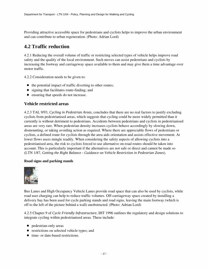
Bus Lanes and High Occupancy Vehicle Lanes provide road space that can also be used by cyclists, whileroad user charging can help to reduce traffic volumes. Off-carriageway space created by installing adelivery bay has been used for cycle parking stands and road signs, leaving the main footway (which isoff to the left of the picture behind a wall) unobstructed. (Photo: Adrian Lord)
4.2.5 Chapter 9 of Cycle Friendly Infrastructure, IHT 1996 outlines the regulatory and design solutions tointegrate cycling within pedestrianised areas. These include:
pedestrian-only areas restrictions on selected vehicle types; and time- or date-based restrictions.
- 17 -
Department for Transport - LTN 1/04 - Policy, Planning and Design for Walking and Cycling
4.2.5 The following examples illustrate some of the techniques available.
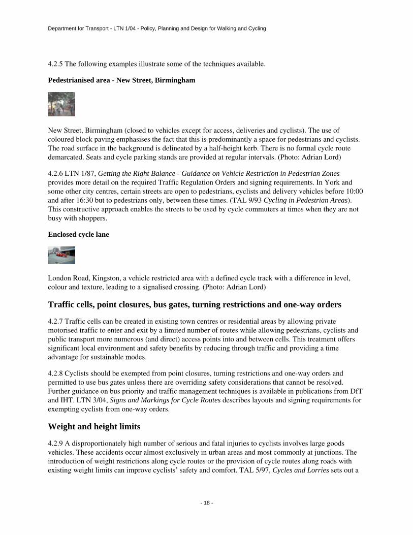
Pedestrianised area - New Street, Birmingham
New Street, Birmingham (closed to vehicles except for access, deliveries and cyclists). The use ofcoloured block paving emphasises the fact that this is predominantly a space for pedestrians and cyclists.The road surface in the background is delineated by a half-height kerb. There is no formal cycle routedemarcated. Seats and cycle parking stands are provided at regular intervals. (Photo: Adrian Lord)
4.2.6 LTN 1/87, Getting the Right Balance - Guidance on Vehicle Restriction in Pedestrian Zonesprovides more detail on the required Traffic Regulation Orders and signing requirements. In York andsome other city centres, certain streets are open to pedestrians, cyclists and delivery vehicles before 10:00and after 16:30 but to pedestrians only, between these times. (TAL 9/93 Cycling in Pedestrian Areas).This constructive approach enables the streets to be used by cycle commuters at times when they are notbusy with shoppers.
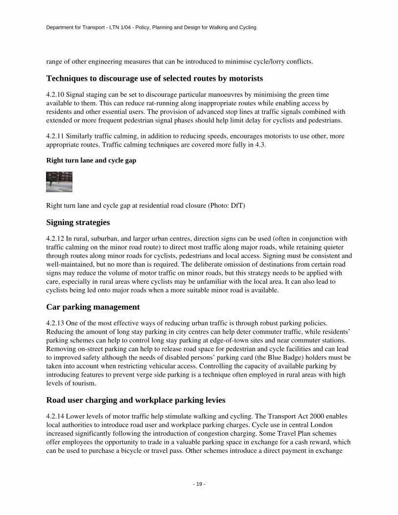
Enclosed cycle lane
London Road, Kingston, a vehicle restricted area with a defined cycle track with a difference in level,colour and texture, leading to a signalised crossing. (Photo: Adrian Lord)
Traffic cells, point closures, bus gates, turning restrictions and one-way orders
4.2.7 Traffic cells can be created in existing town centres or residential areas by allowing privatemotorised traffic to enter and exit by a limited number of routes while allowing pedestrians, cyclists andpublic transport more numerous (and direct) access points into and between cells. This treatment offerssignificant local environment and safety benefits by reducing through traffic and providing a timeadvantage for sustainable modes.
4.2.8 Cyclists should be exempted from point closures, turning restrictions and one-way orders andpermitted to use bus gates unless there are overriding safety considerations that cannot be resolved.Further guidance on bus priority and traffic management techniques is available in publications from DfTand IHT. LTN 3/04, Signs and Markings for Cycle Routes describes layouts and signing requirements forexempting cyclists from one-way orders.
Weight and height limits
4.2.9 A disproportionately high number of serious and fatal injuries to cyclists involves large goodsvehicles. These accidents occur almost exclusively in urban areas and most commonly at junctions. Theintroduction of weight restrictions along cycle routes or the provision of cycle routes along roads withexisting weight limits can improve cyclists’ safety and comfort. TAL 5/97, Cycles and Lorries sets out a
- 18 -
Department for Transport - LTN 1/04 - Policy, Planning and Design for Walking and Cycling
range of other engineering measures that can be introduced to minimise cycle/lorry conflicts.
Techniques to discourage use of selected routes by motorists
4.2.10 Signal staging can be set to discourage particular manoeuvres by minimising the green timeavailable to them. This can reduce rat-running along inappropriate routes while enabling access byresidents and other essential users. The provision of advanced stop lines at traffic signals combined withextended or more frequent pedestrian signal phases should help limit delay for cyclists and pedestrians.
4.2.11 Similarly traffic calming, in addition to reducing speeds, encourages motorists to use other, moreappropriate routes. Traffic calming techniques are covered more fully in 4.3.
Right turn lane and cycle gap
Right turn lane and cycle gap at residential road closure (Photo: DfT)
Signing strategies
4.2.12 In rural, suburban, and larger urban centres, direction signs can be used (often in conjunction withtraffic calming on the minor road route) to direct most traffic along major roads, while retaining quieterthrough routes along minor roads for cyclists, pedestrians and local access. Signing must be consistent andwell-maintained, but no more than is required. The deliberate omission of destinations from certain roadsigns may reduce the volume of motor traffic on minor roads, but this strategy needs to be applied withcare, especially in rural areas where cyclists may be unfamiliar with the local area. It can also lead tocyclists being led onto major roads when a more suitable minor road is available.
Car parking management
4.2.13 One of the most effective ways of reducing urban traffic is through robust parking policies.Reducing the amount of long stay parking in city centres can help deter commuter traffic, while residents’parking schemes can help to control long stay parking at edge-of-town sites and near commuter stations.Removing on-street parking can help to release road space for pedestrian and cycle facilities and can leadto improved safety although the needs of disabled persons’ parking card (the Blue Badge) holders must betaken into account when restricting vehicular access. Controlling the capacity of available parking byintroducing features to prevent verge side parking is a technique often employed in rural areas with highlevels of tourism.
Road user charging and workplace parking levies
4.2.14 Lower levels of motor traffic help stimulate walking and cycling. The Transport Act 2000 enableslocal authorities to introduce road user and workplace parking charges. Cycle use in central Londonincreased significantly following the introduction of congestion charging. Some Travel Plan schemesoffer employees the opportunity to trade in a valuable parking space in exchange for a cash reward, whichcan be used to purchase a bicycle or travel pass. Other schemes introduce a direct payment in exchange
- 19 -
Department for Transport - LTN 1/04 - Policy, Planning and Design for Walking and Cycling

for a parking place.
Bypasses
4.2.15 Towns in the Bypass Demonstration Project were given additional funding to introduce trafficcalming and environmental improvements. The reduction in traffic levels allowed speed limits to bereduced and former through-roads to be re-engineered to reflect their change in status. This has createdimproved conditions for pedestrians and cyclists. Care in the design of the bypass itself can avoid theseverance effect of such roads for pedestrians and cyclists.
Safer Routes to Schools
4.2.16 Safer Routes to Schools schemes offer the opportunity to introduce measures to facilitate walkingand cycling throughout the catchment area of a school or group of schools. Measures should always takeinto account the needs of the wider local community, and should consider personal safety implications inaddition to road safety issues.
Children crossing a road with roadworks
It is important to provide crossings and a higher level of segregation on routes to schools. At such sites,the level of pedestrian activity may be insufficient to warrant a crossing using the traditional numericapproach, but there is clearly a need for additional facilities. LTN 1/95 offers a more flexible approach topedestrian crossing assessment. (Photo: Jon Toy)
Park and Ride
4.2.17 Bus-based park and ride sites are often linked to the city centre by bus priority measures, whichmay also benefit cyclists. Cycle parking at the park and ride site enables users to cycle to the site and thenuse the bus for the busier part of the route, or to drive the longer rural part of a journey and cycle the finalurban section.
Cycle Stands
Cycle stands and lockers at a park and ride site near York. (Photo: DfT)
4.3 Speed reduction
4.3.1 At the heart of the integrated transport policy A New Deal for Transport - better for everyone, DETR1998 is the encouragement of public transport, cycling and walking, and discouragement of using the carfor inappropriate journeys. Traffic calming has a significant role to play in achieving these objectives byimproving the safety and environment of vulnerable road users. A forthcoming LTN, Traffic Calming
- 20 -
Department for Transport - LTN 1/04 - Policy, Planning and Design for Walking and Cycling
Measures, will provide comprehensive guidance on the use of traffic calming measures. It covers relevantlegislation and the design, effectiveness and installation (including signing and lighting) of trafficcalming, and incorporates design features to assist cycling and walking.
4.3.2 Walking has a major role in transport and the Government wants walking to be easier, more pleasantand safer than it is now. Advice to local authorities is given in TAL 2/00, Framework for a Local Walking Strategy, and reiterated in On the Move: By Foot, DfT 2003 a discussion paper reflecting the issues raisedin a series of seminars during 2002. The most important problem is inappropriate vehicle speed. Reducingspeeds, particularly in residential areas and along busy pedestrian routes, would reduce accidentssignificantly and make injuries much less severe.
4.3.3 By reducing the speed, dominance and, at times, the volume of motor vehicles, traffic calming canbenefit cyclists. In older towns and cities where space is at a premium, traffic calming would be anappropriate means of facilitating cycling, as lower speeds and flows can lessen the need to separatecyclists from motor traffic, IHT 1996.
4.3.4 From the outset, local authorities should view traffic calming schemes as an opportunity to improveconditions for cyclists, and scheme designs should be cycle-friendly. The Institution of Highways andTransportation publication Guidelines for Planning and Design of Cycle-Friendly Infrastructure, IHT1996, includes advice on cyclists and traffic calming.
4.3.5 Other sources of detailed design advice include the National Cycle Network: Guidelines andPractical Details Issue 2, Sustrans 1997, and the CSS Traffic Calming guide CSS et al 1994. Particularcare needs to be exercised in rural areas to ensure that engineering measures do not introduceinappropriate ’urban’ features. Rural Routes and Networks, Countryside Agency/Institution of CivilEngineers 2002, gives appropriate examples. A regularly updated Traffic Calming Bibliography isavailable from DfT, giving many references that may be useful when considering a scheme.
20 mph zones
4.3.6 A TRL review of 20 mph zones with traffic calming found that speeds were reduced by about 9 mphand traffic flows reduced by 27%. This led to a 60% reduction in overall accident frequency.
4.3.7 Reductions in pedestrian and cyclist accidents of 63% and 29% respectively have been measuredwhere 20 mph zones were introduced in the UK. Child pedestrian and child cyclist accidents were reducedby 70% and 48% respectively after the introduction of 20 mph zones.
4.3.8 Since 1999, it has been permissible under certain conditions to apply 20 mph speed limits withoutany accompanying traffic calming.
Home zones
4.3.9 These are intended to improve the quality of life of residents. Hard landscaping is often used tocreate an environment where vehicle speeds are reduced to very low figures. Pedestrians, motor trafficand cyclists often share a common surface. The power to designate a home zone is contained in Section268 of the Transport Act 2000.
- 21 -
Department for Transport - LTN 1/04 - Policy, Planning and Design for Walking and Cycling

Home zone road sign
In home zones, pedestrians, cyclists and vehicles mix at low speeds (Photo Wayne Dueden)
Speed limit reduction in villages and on rural links
4.3.10 A range of measures such as village gateways, rumble strips etc can often benefit pedestrians,cyclists and equestrians by reducing speeds. ’Quiet Lanes’ are minor rural roads (or networks of roads)that are appropriate for shared use by walkers, cyclists, horse riders and motorised users. These roadscarry small amounts of motor traffic travelling at low speeds. The DfT’s expectation is that 30 mph speedlimits will apply on all roads that pass through villages. Further information on the design of roads in ruralareas is available from the DfT and the Countryside Agency (Roads in the Countryside, CountrysideAgency 1995, Design Issues for Rural Traffic Management, Countryside Agency 2000 and Rural Routesand Networks, ICE/Countryside Agency 2002.
Traffic calming
4.3.11 Vertical measures include full width humps, speed cushions, speed tables and rumble strips. Roundand flat topped humps with steep ramps can be uncomfortable for cyclists and some disabled people.Sinusoidal profile humps are usually more comfortable, but require careful design and construction (TAL9/98). Pre-cast sinusoidal humps are available from some manufacturers. Cyclists are normally able toride through the gap between speed cushions but side ramp faces should not be steeper than 1:4 and on/offramps not steeper than 1:8 as sometimes it is impossible to avoid riding over the cushions. Full width flattopped speed humps sometimes become informal crossing points for pedestrians, and can be beneficial towheelchair users and people with pushchairs. Rumble strips and corrugated surfacing (with cycle gaps)can be used, although care needs to be taken to ensure that there is no noise disturbance to nearbyproperties.
4.3.12 Horizontal measures include build-outs, chicanes, and central refuges. Motorists will not usuallyattempt to overtake cyclists where the available width is 3.0m or less (TAL 9/94 Horizontal Deflections,and TAL 1/97 Cyclists at Road Narrowings). Widths between 3.1m and 3.9m should be avoided as it is inthis range that motorists will often attempt to overtake cyclists where there is insufficient room to passsafely. Cycle bypasses should be provided where possible, but careful design detailing is needed to avoidproblems with drainage, sweeping and to prevent obstruction by parked vehicles. A bypass should notrequire cyclists to travel additional distance, or require them to give way before rejoining the maincarriageway. Central refuges are helpful to pedestrians, and can encourage people to cross thecarriageway at places where there is good visibility. For a central refuge to safely accommodate cyclists,wheelchair users and pedestrians with pushchairs, it needs to be at least 2.0m wide
4.4 Reallocation of road space to pedestrians
- 22 -
Department for Transport - LTN 1/04 - Policy, Planning and Design for Walking and Cycling
Footway widening
4.4.1 Inclusive Mobility, DfT 2002, recommends a footway width of 2.0m as the minimum under normalcircumstances, with an acceptable minimum of 1.5m. At restrictions or obstacles, an absolute minimumuseable width of 1.0m is acceptable for short distances (maximum length 6.0m). Footways less than 1.2mwide can be inconvenient and sometimes unpleasant to use, and it is often necessary for pedestrians tostep into the carriageway to pass each other. At bus stops, a minimum footway width of 2.0m should beprovided where pedestrian flows are low, increasing to a minimum of 3.0m where they are high. Widthsof 3.5m to 4.5m are recommended outside shops. Carriageway space to widen footways can often bereleased as a result of introducing traffic management schemes or parking restrictions. Scheme designersshould take care that the carriageway width is not reduced to such an extent that cyclists’ safety iscompromised. It may be necessary to introduce speed reduction methods to maintain the safety of cyclistson the carriageway.
Widened footway - Broad Street, Birmingham
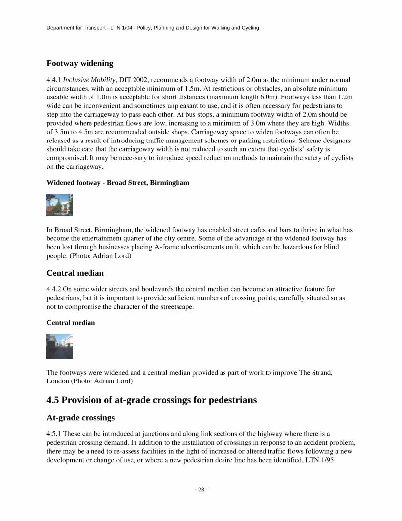
In Broad Street, Birmingham, the widened footway has enabled street cafes and bars to thrive in what hasbecome the entertainment quarter of the city centre. Some of the advantage of the widened footway hasbeen lost through businesses placing A-frame advertisements on it, which can be hazardous for blindpeople. (Photo: Adrian Lord)
Central median
4.4.2 On some wider streets and boulevards the central median can become an attractive feature forpedestrians, but it is important to provide sufficient numbers of crossing points, carefully situated so asnot to compromise the character of the streetscape.
Central median
The footways were widened and a central median provided as part of work to improve The Strand,London (Photo: Adrian Lord)
4.5 Provision of at-grade crossings for pedestrians
At-grade crossings
4.5.1 These can be introduced at junctions and along link sections of the highway where there is apedestrian crossing demand. In addition to the installation of crossings in response to an accident problem,there may be a need to re-assess facilities in the light of increased or altered traffic flows following a newdevelopment or change of use, or where a new pedestrian desire line has been identified. LTN 1/95
- 23 -
Department for Transport - LTN 1/04 - Policy, Planning and Design for Walking and Cycling
recommends a methodology for local authorities to assess where pedestrian crossings are needed and todecide what type of crossing is best for a particular site. LTN 2/95 gives advice on the design ofpedestrian crossings. This LTN is supplemented by Traffic Advisory Leaflets 1/01 and 1/02 about puffincrossings, and they need to be read together.
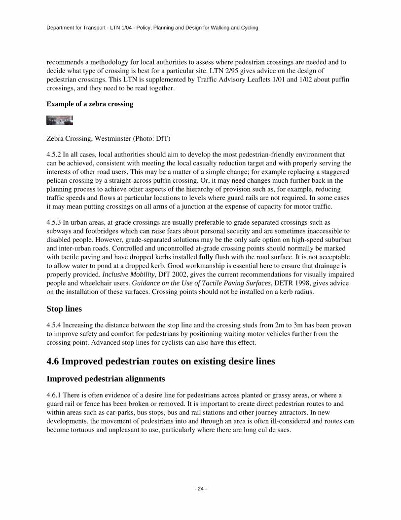
Example of a zebra crossing
Zebra Crossing, Westminster (Photo: DfT)
4.5.2 In all cases, local authorities should aim to develop the most pedestrian-friendly environment thatcan be achieved, consistent with meeting the local casualty reduction target and with properly serving theinterests of other road users. This may be a matter of a simple change; for example replacing a staggeredpelican crossing by a straight-across puffin crossing. Or, it may need changes much further back in theplanning process to achieve other aspects of the hierarchy of provision such as, for example, reducingtraffic speeds and flows at particular locations to levels where guard rails are not required. In some casesit may mean putting crossings on all arms of a junction at the expense of capacity for motor traffic.
4.5.3 In urban areas, at-grade crossings are usually preferable to grade separated crossings such assubways and footbridges which can raise fears about personal security and are sometimes inaccessible todisabled people. However, grade-separated solutions may be the only safe option on high-speed suburbanand inter-urban roads. Controlled and uncontrolled at-grade crossing points should normally be markedwith tactile paving and have dropped kerbs installed fully flush with the road surface. It is not acceptableto allow water to pond at a dropped kerb. Good workmanship is essential here to ensure that drainage isproperly provided. Inclusive Mobility, DfT 2002, gives the current recommendations for visually impairedpeople and wheelchair users. Guidance on the Use of Tactile Paving Surfaces, DETR 1998, gives adviceon the installation of these surfaces. Crossing points should not be installed on a kerb radius.
Stop lines
4.5.4 Increasing the distance between the stop line and the crossing studs from 2m to 3m has been provento improve safety and comfort for pedestrians by positioning waiting motor vehicles further from thecrossing point. Advanced stop lines for cyclists can also have this effect.
4.6 Improved pedestrian routes on existing desire lines
Improved pedestrian alignments
4.6.1 There is often evidence of a desire line for pedestrians across planted or grassy areas, or where aguard rail or fence has been broken or removed. It is important to create direct pedestrian routes to andwithin areas such as car-parks, bus stops, bus and rail stations and other journey attractors. In newdevelopments, the movement of pedestrians into and through an area is often ill-considered and routes canbecome tortuous and unpleasant to use, particularly where there are long cul de sacs.
- 24 -
Department for Transport - LTN 1/04 - Policy, Planning and Design for Walking and Cycling

4.6.2 The improvement of existing pedestrian routes often requires a series of minor changes such asrationalising street furniture to create a clear unobstructed route. This could involve moving signs andlighting columns to the edges of the pedestrian path, improving the paving, and creating at-gradecrossings of side roads by using flat topped speed humps possibly in conjunction with localised roadnarrowing. It can also include re-timing traffic signals to reduce delay to pedestrians and cyclists at signalcontrolled crossings, or introducing additional crossings at junctions.
4.7 New pedestrian-only alignment or grade separation
New alignment
4.7.1 New pedestrian alignments are particularly valuable where they create a short-cut compared with anexisting route. Alongside major roads, especially in suburban and rural areas, it may be appropriate tomove an existing footway from being immediately adjacent to the carriageway for safety or environmentalreasons, so that there is some physical separation such as a verge or hedge. Alternatively, a new alignmentmay be completely away from the highway. In such circumstances, there may be an opportunity tointroduce a new cycle track at the same time if this is desirable and appropriate.
Grade-separated crossings
4.7.2 Where a pedestrian route crosses a major road or a railway line, the most desirable solution may begrade separation. Both ramps and steps should be provided where practicable. Parapet height should be aminimum of 1.4m if cyclists are expected to use a bridge (legally or otherwise), or 1.8m if equestrian useis also expected. See BD 52/93, Design of Highway Bridge Parapets, Design Manual for Roads and Bridges, Highways Agency 1993. Widths for different circumstances are specified in Inclusive Mobility,DfT 2002, and other references (see 4.7.3).
Example of a grade-separation crossing - Paradise Circus Queensway, Birmingham
If possible, the design of the scheme should ensure that pedestrians have a minimal change of level by, forexample, putting the road in a cutting such as here at Paradise Circus Queensway, Birmingham. Thisscheme enabled expansion of the city centre into an area that was previously cut off by the inner ring road.(Photo: Adrian Lord)
4.7.3 Key references are Inclusive Mobility, DfT 2002, and Design Manual for Roads and BridgesTD36/93 Subways for Pedestrians and Pedal Cyclists: Layout and Dimensions, Highways Agency 1993.Acceptable pedestrian ramp gradients range from less than 5%, up to 10% in exceptional circumstances.Cycle ramp gradients should preferably be less than 3% and should not normally exceed 5%. If space isvery restricted, a gradient of up to 7% may be used. Ramps may need to include landings as resting pointsfor wheelchair users. Guidance on distances between landings is given in Inclusive Mobility.
- 25 -
Department for Transport - LTN 1/04 - Policy, Planning and Design for Walking and Cycling
4.8 Complementary and trip-end facilities for pedestrians
Signing, Route Maps and Information
4.8.1 Signing is essential for visitors to an area, and signing of key destinations from railway/bus stationsand other points of arrival is important. Where non-highway standard direction signing is used forpedestrians and cyclists, it must be clear and legible with good colour contrast between letters andbackgrounds. Signs and tactile maps for visually impaired people should be designed in accordance with Inclusive Mobility, DfT, 2002.
4.8.2 Street maps can be installed at strategic locations throughout the town centre, and should also beavailable from information points at transport interchanges. Route maps offer opportunities for thepromotion of walking for health and leisure through themed walks, such as fitness walks or historic walks.
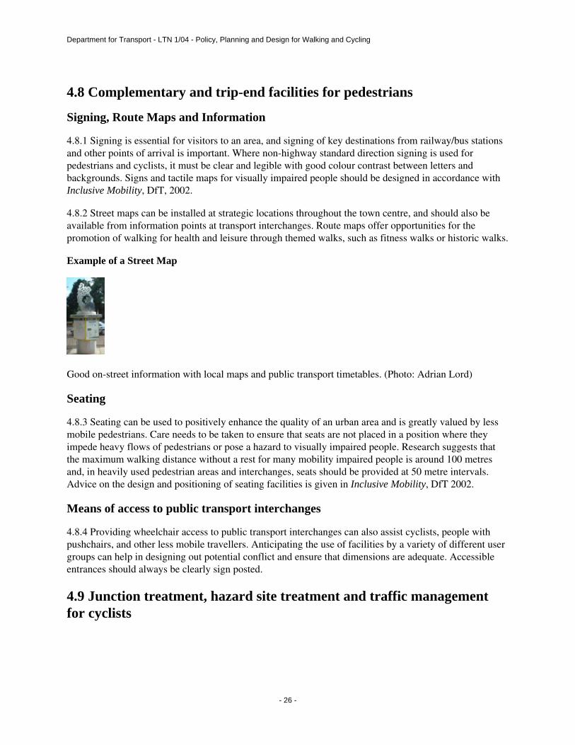
Example of a Street Map
Good on-street information with local maps and public transport timetables. (Photo: Adrian Lord)
Seating
4.8.3 Seating can be used to positively enhance the quality of an urban area and is greatly valued by lessmobile pedestrians. Care needs to be taken to ensure that seats are not placed in a position where theyimpede heavy flows of pedestrians or pose a hazard to visually impaired people. Research suggests thatthe maximum walking distance without a rest for many mobility impaired people is around 100 metresand, in heavily used pedestrian areas and interchanges, seats should be provided at 50 metre intervals.Advice on the design and positioning of seating facilities is given in Inclusive Mobility, DfT 2002.
Means of access to public transport interchanges
4.8.4 Providing wheelchair access to public transport interchanges can also assist cyclists, people withpushchairs, and other less mobile travellers. Anticipating the use of facilities by a variety of different usergroups can help in designing out potential conflict and ensure that dimensions are adequate. Accessibleentrances should always be clearly sign posted.
4.9 Junction treatment, hazard site treatment and traffic managementfor cyclists
- 26 -
Department for Transport - LTN 1/04 - Policy, Planning and Design for Walking and Cycling

Advanced Stop Lines
4.9.1 ASLs enable cyclists to position themselves ahead of other traffic during the red phase at signalisedjunctions. Cyclists at ASLs are more visible to other traffic and are therefore better placed to executemanoeuvres that might otherwise conflict with the movement of motor vehicles. Cyclists also benefit frombeing able to queue away from harmful exhaust emissions. ASLs allow cyclists who want to go straightahead to get in front of motor vehicles intending to turn left. They are also useful to cyclists who need tomake a right turn. (TAL 5/96 and TAL 8/93). ASLs can also benefit pedestrians, as motor vehicles arerequired to wait further from the crossing area and are therefore less intimidating.
Example of an Advanced Stop Line (ASL)
ASL with mandatory feeder lane (Photo: Adrian Lord)
Cycle route priority crossing
4.9.2 Off-carriageway cycle tracks parallel to a main route may have to cross a number of side roads.These crossings are normally configured so that the side road has priority over the cycle track. Whereappropriate, the priority may be reversed by placing the cycle track on a flat topped speed hump andputting give-way markings on the side road. This may be reinforced by other traffic calming measures.
Cycle Track
Cycle track with priority over side road. (Photo: Tony Russell)
4.9.3 Mandatory cycle lanes within the carriageway cannot be continued across the mouth of a side road.In these circumstances, the mandatory lane is terminated each side of the junction and the lane continuespast the side road as an advisory one (often with coloured surfacing to reinforce visibility).
Toucan crossing
4.9.4 A Toucan crossing is an unsegregated signal controlled crossing for cyclists and pedestrians.Cyclists may use the crossing without dismounting. It is important that there is enough width on theapproaches and on the crossing itself to minimise the potential for conflict between users. Cyclists andpedestrians on the approaches may be segregated, and this can continue right up to the kerb line butsegregation is usually terminated before the waiting areas (see TALs 10/93 and 4/98).
4.9.5 Toucan crossings work best when the flow of either group of users wishing to cross is not too great.As flows increase, these crossings may experience operational difficulties. If so, pedestrian and cycleflows may be better served by parallel crossings, or entirely separate ones.
- 27 -
Department for Transport - LTN 1/04 - Policy, Planning and Design for Walking and Cycling
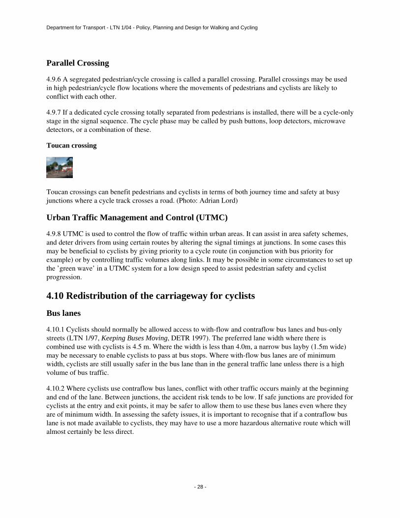
Parallel Crossing
4.9.6 A segregated pedestrian/cycle crossing is called a parallel crossing. Parallel crossings may be usedin high pedestrian/cycle flow locations where the movements of pedestrians and cyclists are likely toconflict with each other.
4.9.7 If a dedicated cycle crossing totally separated from pedestrians is installed, there will be a cycle-onlystage in the signal sequence. The cycle phase may be called by push buttons, loop detectors, microwavedetectors, or a combination of these.
Toucan crossing
Toucan crossings can benefit pedestrians and cyclists in terms of both journey time and safety at busyjunctions where a cycle track crosses a road. (Photo: Adrian Lord)
Urban Traffic Management and Control (UTMC)
4.9.8 UTMC is used to control the flow of traffic within urban areas. It can assist in area safety schemes,and deter drivers from using certain routes by altering the signal timings at junctions. In some cases thismay be beneficial to cyclists by giving priority to a cycle route (in conjunction with bus priority forexample) or by controlling traffic volumes along links. It may be possible in some circumstances to set upthe ’green wave’ in a UTMC system for a low design speed to assist pedestrian safety and cyclistprogression.
4.10 Redistribution of the carriageway for cyclists
Bus lanes
4.10.1 Cyclists should normally be allowed access to with-flow and contraflow bus lanes and bus-onlystreets (LTN 1/97, Keeping Buses Moving, DETR 1997). The preferred lane width where there iscombined use with cyclists is 4.5 m. Where the width is less than 4.0m, a narrow bus layby (1.5m wide)may be necessary to enable cyclists to pass at bus stops. Where with-flow bus lanes are of minimumwidth, cyclists are still usually safer in the bus lane than in the general traffic lane unless there is a highvolume of bus traffic.
4.10.2 Where cyclists use contraflow bus lanes, conflict with other traffic occurs mainly at the beginningand end of the lane. Between junctions, the accident risk tends to be low. If safe junctions are provided forcyclists at the entry and exit points, it may be safer to allow them to use these bus lanes even where theyare of minimum width. In assessing the safety issues, it is important to recognise that if a contraflow buslane is not made available to cyclists, they may have to use a more hazardous alternative route which willalmost certainly be less direct.
- 28 -
Department for Transport - LTN 1/04 - Policy, Planning and Design for Walking and Cycling
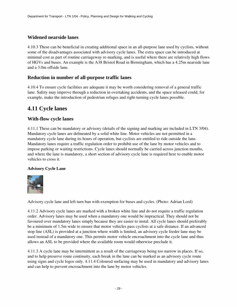
Widened nearside lanes
4.10.3 These can be beneficial in creating additional space in an all-purpose lane used by cyclists, withoutsome of the disadvantages associated with advisory cycle lanes. The extra space can be introduced atminimal cost as part of routine carriageway re-marking, and is useful where there are relatively high flowsof HGVs and buses. An example is the A38 Bristol Road in Birmingham, which has a 4.25m nearside laneand a 3.0m offside lane.
Reduction in number of all-purpose traffic lanes
4.10.4 To ensure cycle facilities are adequate it may be worth considering removal of a general trafficlane. Safety may improve through a reduction in overtaking accidents, and the space released could, forexample, make the introduction of pedestrian refuges and right-turning cycle lanes possible.
4.11 Cycle lanes
With-flow cycle lanes
4.11.1 These can be mandatory or advisory (details of the signing and marking are included in LTN 3/04).Mandatory cycle lanes are delineated by a solid white line. Motor vehicles are not permitted in amandatory cycle lane during its hours of operation, but cyclists are entitled to ride outside the lane.Mandatory lanes require a traffic regulation order to prohibit use of the lane by motor vehicles and toimpose parking or waiting restrictions. Cycle lanes should normally be carried across junction mouths,and where the lane is mandatory, a short section of advisory cycle lane is required here to enable motorvehicles to cross it.
Advisory Cycle Lane
Advisory cycle lane and left turn ban with exemption for buses and cycles. (Photo: Adrian Lord)
4.11.2 Advisory cycle lanes are marked with a broken white line and do not require a traffic regulationorder. Advisory lanes may be used when a mandatory one would be impractical. They should not befavoured over mandatory lanes simply because they are easier to instal. All cycle lanes should preferablybe a minimum of 1.5m wide to ensure that motor vehicles pass cyclists at a safe distance. If an advancedstop line (ASL) is provided at a junction where width is limited, an advisory cycle feeder lane may beused instead of a mandatory one. This permits motor vehicle encroachment into the cycle lane and thusallows an ASL to be provided where the available room would otherwise preclude it.
4.11.3 A cycle lane may be intermittent as a result of the carriageway being too narrow in places. If so,and to help preserve route continuity, each break in the lane can be marked as an advisory cycle routeusing signs and cycle logos only. 4.11.4 Coloured surfacing may be used in mandatory and advisory lanesand can help to prevent encroachment into the lane by motor vehicles.
- 29 -
Department for Transport - LTN 1/04 - Policy, Planning and Design for Walking and Cycling
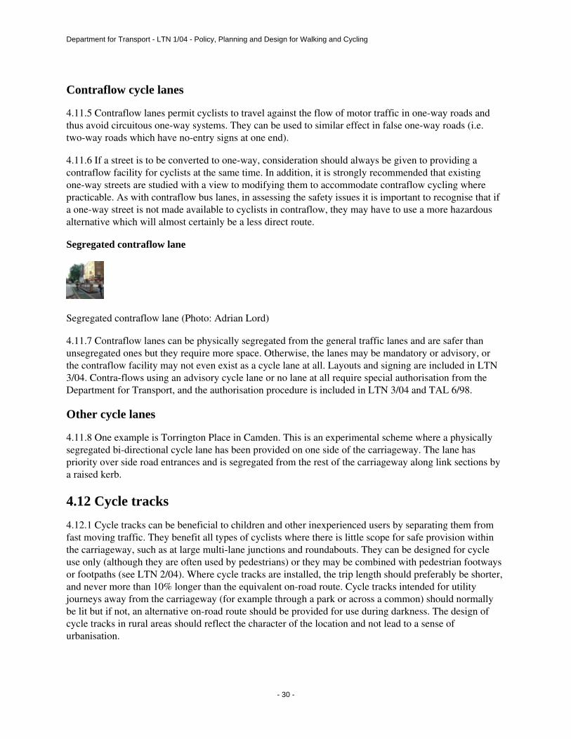
Contraflow cycle lanes
4.11.5 Contraflow lanes permit cyclists to travel against the flow of motor traffic in one-way roads andthus avoid circuitous one-way systems. They can be used to similar effect in false one-way roads (i.e.two-way roads which have no-entry signs at one end).
4.11.6 If a street is to be converted to one-way, consideration should always be given to providing acontraflow facility for cyclists at the same time. In addition, it is strongly recommended that existingone-way streets are studied with a view to modifying them to accommodate contraflow cycling wherepracticable. As with contraflow bus lanes, in assessing the safety issues it is important to recognise that ifa one-way street is not made available to cyclists in contraflow, they may have to use a more hazardousalternative which will almost certainly be a less direct route.
Segregated contraflow lane
Segregated contraflow lane (Photo: Adrian Lord)
4.11.7 Contraflow lanes can be physically segregated from the general traffic lanes and are safer thanunsegregated ones but they require more space. Otherwise, the lanes may be mandatory or advisory, orthe contraflow facility may not even exist as a cycle lane at all. Layouts and signing are included in LTN3/04. Contra-flows using an advisory cycle lane or no lane at all require special authorisation from theDepartment for Transport, and the authorisation procedure is included in LTN 3/04 and TAL 6/98.
Other cycle lanes
4.11.8 One example is Torrington Place in Camden. This is an experimental scheme where a physicallysegregated bi-directional cycle lane has been provided on one side of the carriageway. The lane haspriority over side road entrances and is segregated from the rest of the carriageway along link sections bya raised kerb.
4.12 Cycle tracks
4.12.1 Cycle tracks can be beneficial to children and other inexperienced users by separating them fromfast moving traffic. They benefit all types of cyclists where there is little scope for safe provision withinthe carriageway, such as at large multi-lane junctions and roundabouts. They can be designed for cycleuse only (although they are often used by pedestrians) or they may be combined with pedestrian footwaysor footpaths (see LTN 2/04). Where cycle tracks are installed, the trip length should preferably be shorter,and never more than 10% longer than the equivalent on-road route. Cycle tracks intended for utilityjourneys away from the carriageway (for example through a park or across a common) should normallybe lit but if not, an alternative on-road route should be provided for use during darkness. The design ofcycle tracks in rural areas should reflect the character of the location and not lead to a sense ofurbanisation.
- 30 -
Department for Transport - LTN 1/04 - Policy, Planning and Design for Walking and Cycling
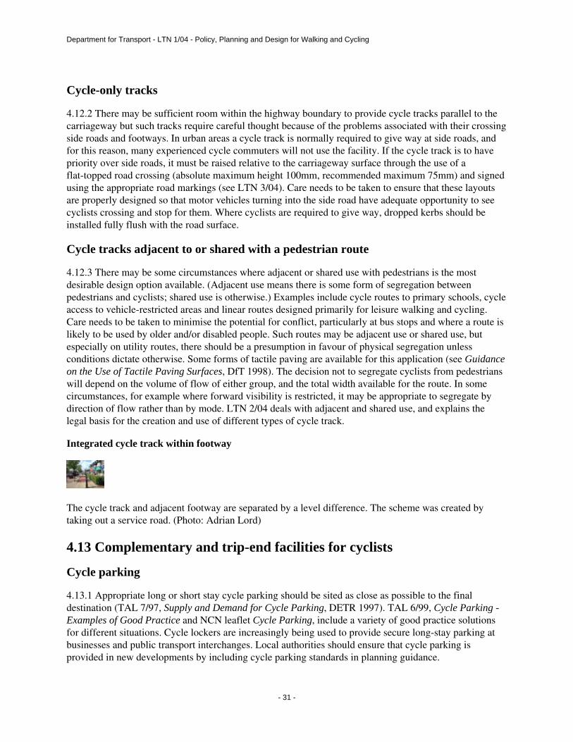
Cycle-only tracks
4.12.2 There may be sufficient room within the highway boundary to provide cycle tracks parallel to thecarriageway but such tracks require careful thought because of the problems associated with their crossingside roads and footways. In urban areas a cycle track is normally required to give way at side roads, andfor this reason, many experienced cycle commuters will not use the facility. If the cycle track is to havepriority over side roads, it must be raised relative to the carriageway surface through the use of aflat-topped road crossing (absolute maximum height 100mm, recommended maximum 75mm) and signedusing the appropriate road markings (see LTN 3/04). Care needs to be taken to ensure that these layoutsare properly designed so that motor vehicles turning into the side road have adequate opportunity to seecyclists crossing and stop for them. Where cyclists are required to give way, dropped kerbs should beinstalled fully flush with the road surface.
Cycle tracks adjacent to or shared with a pedestrian route
4.12.3 There may be some circumstances where adjacent or shared use with pedestrians is the mostdesirable design option available. (Adjacent use means there is some form of segregation betweenpedestrians and cyclists; shared use is otherwise.) Examples include cycle routes to primary schools, cycleaccess to vehicle-restricted areas and linear routes designed primarily for leisure walking and cycling.Care needs to be taken to minimise the potential for conflict, particularly at bus stops and where a route islikely to be used by older and/or disabled people. Such routes may be adjacent use or shared use, butespecially on utility routes, there should be a presumption in favour of physical segregation unlessconditions dictate otherwise. Some forms of tactile paving are available for this application (see Guidanceon the Use of Tactile Paving Surfaces, DfT 1998). The decision not to segregate cyclists from pedestrianswill depend on the volume of flow of either group, and the total width available for the route. In somecircumstances, for example where forward visibility is restricted, it may be appropriate to segregate bydirection of flow rather than by mode. LTN 2/04 deals with adjacent and shared use, and explains thelegal basis for the creation and use of different types of cycle track.
Integrated cycle track within footway
The cycle track and adjacent footway are separated by a level difference. The scheme was created bytaking out a service road. (Photo: Adrian Lord)
4.13 Complementary and trip-end facilities for cyclists
Cycle parking
4.13.1 Appropriate long or short stay cycle parking should be sited as close as possible to the finaldestination (TAL 7/97, Supply and Demand for Cycle Parking, DETR 1997). TAL 6/99, Cycle Parking -Examples of Good Practice and NCN leaflet Cycle Parking, include a variety of good practice solutionsfor different situations. Cycle lockers are increasingly being used to provide secure long-stay parking atbusinesses and public transport interchanges. Local authorities should ensure that cycle parking isprovided in new developments by including cycle parking standards in planning guidance.
- 31 -
Department for Transport - LTN 1/04 - Policy, Planning and Design for Walking and Cycling

Cycle Locker
Cycle lockers can be used to provide secure long stay parking at stations (Photo DfT)
4.13.2 Poorly sited cycle parking or lack of formal parking can create hazards for blind or partiallysighted people. Some parking stands now incorporate tapping rails and these are preferred (tapping railsnot only assist blind people using sticks but they help prevent guide dogs walking through the stands). Thefacilities should not interfere with visibility splays and should avoid pedestrian desire lines. Goodlocations for cycle parking are build-outs created by removing car parking spaces, and these cansometimes be combined with informal pedestrian crossing points. Good examples include KensingtonHigh St where cycle parking is provided on the central reserve (see below), and Notting Hill Gate andBrompton Road (see 4.2), which have cycle parking stands on build-outs next to car parking bays.
Cycle parking in central reserve
Cycle parking in central reserve, High Street, Kensington. (Photo: DfT)
14.3.3 Cycle parking in rural and historic areas may be constructed from cast iron or other suitablematerials, using designs that fit in with the surrounding street furniture. Designs should be convenient andsecure without being visually obtrusive or over-engineered.
Cycle Parking contained within build outs
Cycle parking bay protected by build outs. (Photo: Alex Sully, English Regions Cycling DevelopmentTeam)
Signing
4.13.4 Care should be taken to ensure that route signing is easy to follow and legally correct, and that keydestinations are included especially where the route of the cycle track and/or pedestrian footpath differsfrom the route used by motor traffic. Signing needs particular emphasis where shared-use ends andpedestrian-only routes begin. Signing may be supplemented by road marking such as the cycle symbol onadvisory routes (see LTN 3/04).
- 32 -
Department for Transport - LTN 1/04 - Policy, Planning and Design for Walking and Cycling
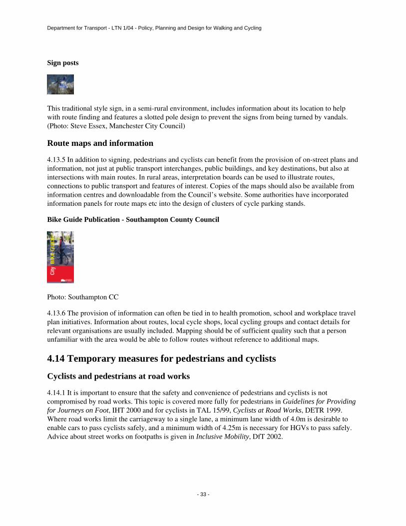
Sign posts
This traditional style sign, in a semi-rural environment, includes information about its location to helpwith route finding and features a slotted pole design to prevent the signs from being turned by vandals.(Photo: Steve Essex, Manchester City Council)
Route maps and information
4.13.5 In addition to signing, pedestrians and cyclists can benefit from the provision of on-street plans andinformation, not just at public transport interchanges, public buildings, and key destinations, but also atintersections with main routes. In rural areas, interpretation boards can be used to illustrate routes,connections to public transport and features of interest. Copies of the maps should also be available frominformation centres and downloadable from the Council’s website. Some authorities have incorporatedinformation panels for route maps etc into the design of clusters of cycle parking stands.
Bike Guide Publication - Southampton County Council
Photo: Southampton CC
4.13.6 The provision of information can often be tied in to health promotion, school and workplace travelplan initiatives. Information about routes, local cycle shops, local cycling groups and contact details forrelevant organisations are usually included. Mapping should be of sufficient quality such that a personunfamiliar with the area would be able to follow routes without reference to additional maps.
4.14 Temporary measures for pedestrians and cyclists
Cyclists and pedestrians at road works
4.14.1 It is important to ensure that the safety and convenience of pedestrians and cyclists is notcompromised by road works. This topic is covered more fully for pedestrians in Guidelines for Providingfor Journeys on Foot, IHT 2000 and for cyclists in TAL 15/99, Cyclists at Road Works, DETR 1999.Where road works limit the carriageway to a single lane, a minimum lane width of 4.0m is desirable toenable cars to pass cyclists safely, and a minimum width of 4.25m is necessary for HGVs to pass safely.Advice about street works on footpaths is given in Inclusive Mobility, DfT 2002.
- 33 -
Department for Transport - LTN 1/04 - Policy, Planning and Design for Walking and Cycling
5. Key References and Useful Addresses
5.1 General
5.1.1 Some of the key texts giving advice on good practice, and preferred design solutions and dimensionsare listed below. Many can be accessed from DfT website (www.dft.gov.uk) or from the National CyclingStrategy website (www.nationalcyclingstrategy.org.uk ). A national website for walking is to bedeveloped in the near future. Regularly updated cycling, walking and traffic calming bibliographies areavailable from the DfT, which detail publications by the DfT and many other organisations.
5.2 Walking
5.2.1 On the Move by Foot: a Discussion Paper, DfT 2003. Sets out ideas for encouraging more walkingthrough planning, design and encouragement measures.
5.2.2 Guidelines for Providing for Journeys on Foot, IHT 2000. Main principles and references for goodpractice in catering for pedestrians.
5.2.3 Walking: Making it Happen, London Walking Forum 2000. Contains many examples of goodpractice in applying policies, plans and programmes to promote and facilitate walking.
5.2.4 Inclusive Mobility: A Guide to Best Practice on Access to Pedestrian and Transport Infrastructure,DfT 2002. Also available from the DfT web site 2
5.2.5 Guidance on the Use of Tactile Paving Surfaces, DETR 1998. Also available from the DfT web site 3
5.2.6 DIY Community Street Audits, Living Streets 2002. A self-help guide for communities to identifyopportunities for improving local conditions for people on foot.
5.2.7 The Assessment of Pedestrian Crossings, LTN 1/95, DoT 1995 and LTN 2/95 The Design ofPedestrian Crossings, DoT 1995.
5.3 Cycling
5.3.1 LTN 3/04, Signs and Markings for Cycle Routes includes the range of prescribed signs available andtheir correct usage.
5.3.2 Cycle Friendly Infrastructure, IHT 1996. Main principles and references for all aspects of providingfor journeys by bike, including trip-end facilities.
5.3.3 London Cycle Network Design Manual, LCN 1998. Contains guidance on how to implement routesfor cyclists in typical urban situations where optimal conditions are difficult to achieve.
5.3.4 National Cycle Network: Guidelines for Planning and Design, Sustrans 1997. Design guidanceintended to cater for novice, child and less-experienced cyclists requiring higher levels of separation frommotor traffic.
- 34 -
Department for Transport - LTN 1/04 - Policy, Planning and Design for Walking and Cycling

5.4 Walking and cycling
5.4.1 LTN 2/04, Adjacent and Shared Use Facilities for Pedestrians and Cyclists, DfT 2004. Sets out thedesign criteria for implementing a shared-use scheme.
5.4.2 TAL 1/87, Measures to Control Traffic for the Benefit of Residents, Pedestrians and Cyclists is abrief review of traffic calming techniques.
5.4.3 Forthcoming LTN, Traffic Calming, DfT. This document will contain the latest guidance on trafficcalming principles and techniques, including the application of traffic calming measures along mainroads.
5.4.4 By Design - Urban design in the planning system: towards better practice, DETR 2000. This guideby the Commission for Architecture and the Built Environment (CABE) aims to promote higher standardsin urban design and acts as a companion to PPG1 General Policy and Principles, which sets the policy forurban design.
5.4.5 Design Bulletin 32 and companion volume Places, Streets and Movement, DETR 1998. The primarydesign guidance for residential areas although now in need of revision. Includes footway and cycle trackwidths, kerb radii and sightlines as well as more general guidance about layout and design.
5.4.6 Better Places to Live, ODPM 2001. This guide is a companion to PPG3 (Housing), DETR 2000. Itaims to improve the quality of design in residential areas and provides advice on how to create a goodmovement framework for residential areas. Better streets, Better places: Delivering SustainableResidential Environments, DfT 2003, examines progress towards meeting the requirements of PPG3.
5.4.7 Going to Town - Improving Town Centre Access, ODPM/National Retail Planning Forum 2002, is acompanion guide to PPG6: Town Centres and Retail Developments, DETR 1996, and sets out goodpractice for design of town centres.
5.4.8 Best Practice to Promote Walking and Cycling, (ADONIS Project Report 3). Report for EU fromDanish Roads Directorate 1998. Includes examples of innovative solutions from a number of Europeancountries.
5.4.9 Transport in the Urban Environment, IHT 1997. Wide-ranging document providing an overview ofthe main traffic management techniques applicable to urban transport, including catering for pedestriansand cyclists. Useful as an initial source of information about issues such as parking management, vehiclerestrictions and other measures that may indirectly improve conditions for pedestrians and cyclists.
5.4.10 Cycling: the way ahead for towns and cities, European Commission, DG XI 1999. Includes severalsuccessful examples of how cycling provision and promotional strategies have been undertaken inEuropean towns and cities, and comparisons of cycle ownership and use.
5.4.11 Roads in the Countryside, Countryside Agency 1995, looks at the general design of roads withinrural areas.
- 35 -
Department for Transport - LTN 1/04 - Policy, Planning and Design for Walking and Cycling

5.4.12 Quiet Roads: Taming Country Lanes, Countryside Agency, 1998 looks specifically at the issue ofproviding rural roads that are attractive and safe for pedestrians, cyclists and equestrians as well as formotor traffic.
5.4.13 Public Rights of Way, Circular 2/93, DoE 1993, gives detailed advice about the topic. Further detailon the latest developments is available from the DEFRA and Countryside Agency web sites.
5.5 Transport, health and environment
5.5.1 Cycling Towards Health and Safety, British Medical Association 1992. Identifies the much greaterhealth benefits of cycling compared with the risks posed by traffic danger.
5.5.2 Active Transport, Health Education Authority 1999. Gives an overview of issues and case studies ofinitiatives to promote walking and cycling.
5.5.3 Making T.H.E. Links, Health Education Authority 1999. A guide for local authorities and healthcareproviders on integrating sustainable transport, health and environmental policies.
5.5.4 Our Healthier Nation, Department of Health 1999. Government policy statement on health.
5.5.5 National Air Quality Strategy, DETR 2000. Government Strategy to reduce air pollution fromtransport and other sources.
5.5.6 Making Travel Plans Work: Lessons from UK Case Studies, DfT 2003. Case studies of successfulworkplace strategies to reduce car use and encourage walking, cycling and other modes.
5.5.7 Planning out Crime, Circular 5/94, DoE 1994. Gives advice on crime reduction aspects of designingroads, footpaths and open public space.
5.5.8 Making the Connections - Transport and Social Exclusion, Social Exclusion Unit, ODPM 2003.Looks at the crucial role of transport in providing access to education, employment, health care and otherservices.
5.6 Road safety
5.6.1 Tomorrow’s Roads: Safer for Everyone, DETR 2000 sets out the Government Policy on road safetyand targets for reducing the number of casualties.
5.6.2 New Directions in Speed Management: a Review of Policy, DETR 2000 specifically deals withGovernment policy on motor vehicle speeds and their role in road safety and transport planning.
5.7 Useful addresses
5.7.1
DfT Free LiteratureP O Box 236Wetherby
- 36 -
Department for Transport - LTN 1/04 - Policy, Planning and Design for Walking and Cycling
West YorkshireLS23 7NB
Tel: 0870 1226 236Minicom 0870 1226 405Fax: 0870 1226 237Email: [email protected]
5.7.2
DfT Traffic Advisory LeafletsCharging & Local Transport DivisionZone 3/19, Great Minster House76 Marsham StreetLondonSW1P 4DR
Tel 020 7944 2478
5.7.3
DfT Mobility and Inclusion Unit(advice on accessible pedestrian environments and installation of tactile paving).
Zone 1/18, Great Minster House76 Marsham StreetLondonSW1P 4DR
Tel 020 7944 6100Minicom 020 7944 3277Email: [email protected]
5.7.4
Highways Agency Publications OfficerHeron House49/53 Goldington RoadBedfordMK40 3LL
5.7.5
Countryside AgencyJohn Dower HouseCrescent PlaceCheltenham,GloucestershireGL50 3RA
- 37 -
Department for Transport - LTN 1/04 - Policy, Planning and Design for Walking and Cycling

Email: [email protected]
5.7.6
Sustrans Head Office35 King StreetBristol BS1 4DZ
Tel: 0117 926 8893Fax: 0117 929 4173
2 Inclusive Mobility: A Guide to Best Practice on Access to Pedestrian and Transport Infrastructure:http://www.dft.gov.uk/transportforyou/access/tipws/inclusivemobility
3 Guidance on the Use of Tactile Paving Surfaces:http://www.dft.gov.uk/transportforyou/access/tipws/guidanceontheuseoftactilepav6167
Annex A Figure 1: Walking Infrastructure Design Process
Figure 2: Cycling Infrastructure Design Process
- 38 -
Department for Transport - LTN 1/04 - Policy, Planning and Design for Walking and Cycling