Delivery guide for Environmental Noise Data...Núria Blanes, Maria José Ramos, Miquel Sáinz de la...
28
Delivery guide for Environmental Noise Data Submission of DF1_DF5: Major roads, major railways, major airports and agglomerations designated by the MS ETC/ACM Technical Paper 2017 November 2017 Núria Blanes, Maria José Ramos, Miquel Sáinz de la Maza, Jaume Fons, Roman Ortner, Colin Nugent, Martin Adams The European Topic Centre on Air Pollution and Climate Change Mitigation (ETC/ACM) is a consortium of European institutes under contract of the European Environment Agency RIVM Aether CHMI CSICEMISIAINERIS NILU ÖKO‐Institut ÖKO‐Recherche PBL UAB UBA‐V VITO 4Sfera
Transcript of Delivery guide for Environmental Noise Data...Núria Blanes, Maria José Ramos, Miquel Sáinz de la...
Delivery guide for Environmental Noise Data
Submission of DF1_DF5: Major roads, major railways, major airports
and agglomerations designated by the MS
ETC/ACM Technical Paper 2017 November 2017
Núria Blanes, Maria José Ramos, Miquel Sáinz de la Maza, Jaume Fons, Roman Ortner, Colin Nugent, Martin Adams
The European Topic Centre on Air Pollution and Climate Change Mitigation (ETC/ACM) is a consortium of European institutes under contract of the European Environment Agency
RIVM Aether CHMI CSICEMISIAINERIS NILU ÖKO‐Institut ÖKO‐Recherche PBL UAB UBA‐V VITO 4Sfera
Front page picture: EEA Reportnet webpage Author affiliation: Núria Blanes, Maria José Ramos, Miquel Sáinz de la Maza, Jaume Fons, UAB (ES) Roman Ortner (UBA‐A) Colin Nugent, Martin Adams (EEA)
DISCLAIMER
This ETC/ACM Technical Paper has not been subjected to European Environment Agency (EEA) member country review. It does not represent the formal views of the EEA.
© ETC/ACM, 2017. ETC/ACM Technical Paper 2017 European Topic Centre on Air Pollution and Climate Change Mitigation PO Box 1 3720 BA Bilthoven The Netherlands Phone +31 30 2748562 Fax +31 30 2744433 Email [email protected] Website http://acm.eionet.europa.eu/

Meta information on this Technical Paper Task reference IP Task # Task Title ETC Task leader EEA contact Persons
2017 1.1.1.10 Ad‐hoc support to Eionet reportnet automatic QA/QC
Miquel Sáinz Martin Adams
Type, titlesandseries number of report Type of report: ETC/ACM Technical Paper Title: Delivery guide for Environmental Noise DataSub title: Submission of DF1_DF5: Major roads, major railways, major airports and agglomerations
designated by the MS Number: (*) (*)Obtaining a series number: See instructions at the Eionet Forum IG "ETC/ACM Consortium": http://forum.eionet.europa.eu/etc‐acm‐consortium/library/general_etc_acc/templates_examples/etc‐acm‐technical‐paper‐web‐publication‐instructions‐1‐p.‐doc‐33kb Authors
Name Institute Name Institute Lead Author: Núria Blanes UAB Co‐authors: Maria José Ramos UAB Roman Ortner UBA‐A Miquel Sáinz de la Maza UAB Colin Nugent EEA Jaume Fons UAB Reviewers: Internal and external task reviewers Within Task
Ext. Task
Ext.ETC Reviewer(s) Institute Motivation / Comment for involvement
(mark with x) (expert, user, program manager, audience, etc.)X X Martin Adams EEA
Status & Deadlines
(**) Planned deadlineaccording Impl. Plan Actual date of delivery
“First Draft for approval by EEA” 30.12.2017 21.11.2017 “Final Draft for approval by EEA” 30.12.2017 “Final Version ‐ Approved by EEA” 30.12.2017 Publication (**) Deliver to Eionet Forum IG "ETC/ACM Consortium" in itsappropriate pre‐defined IP‐and Task‐subfolder at: http://forum.eionet.europa.eu/etc‐acm‐consortium/library Web publication guidance: You find the necessary guidance on the production and review procedures and on styles and templates in the document Report production and review guidelines of the ETC/ACM (PDF) at http://forum.eionet.europa.eu/etc‐acm‐consortium/library/general_etc_acc/templates_examples/report‐production‐review‐guidelines‐etc‐acm‐doc‐166kb. The ETC/ACM Technical Paper will be published at http://air‐climate.eionet.europa.eu/reports/#tp
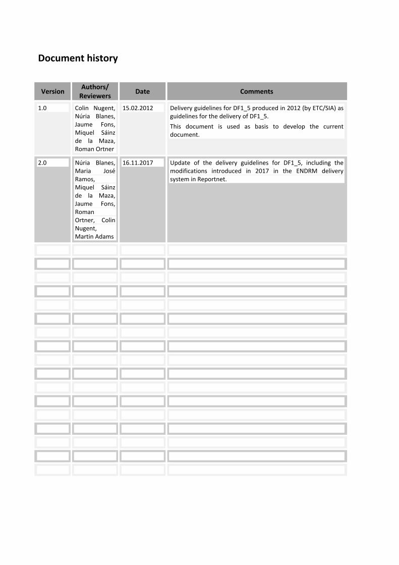
Document history
Version Authors/ Reviewers Date Comments
1.0 Colin Nugent, Núria Blanes, Jaume Fons, Miquel Sáinz de la Maza, Roman Ortner
15.02.2012 Delivery guidelines for DF1_5 produced in 2012 (by ETC/SIA) as guidelines for the delivery of DF1_5. This document is used as basis to develop the current document.
2.0 Núria Blanes, Maria José Ramos, Miquel Sáinz de la Maza, Jaume Fons, Roman Ortner, Colin Nugent, Martin Adams
16.11.2017 Update of the delivery guidelines for DF1_5, including the modifications introduced in 2017 in the ENDRM delivery system in Reportnet.

Contents 1 Outline of the delivery ..................................................................................... 7
2 Data submission process ............................................................................... 9
3 Check list for the data reporters ................................................................... 11
4 Tabular information ....................................................................................... 12 4.1 Data to be reported corresponding to agglomerations > 100.000
inhabitants ............................................................................................. 13 4.2 Data to be reported corresponding to Major roads with more than
3.000.000 vehicles / year ...................................................................... 14 4.3 Data to be reported corresponding to Major railways with more than
30.000 train passages / year ................................................................. 16 4.4 Data to be reported corresponding to Major airports with more than
50.000 movements / year ...................................................................... 18
5 Spatial information ........................................................................................ 20 5.1 Noise sources location .......................................................................... 20 5.2 Spatial data expected to be received .................................................... 21
6 Supplementary information .......................................................................... 23
7 Metadata ......................................................................................................... 24 7.1 Metadata for the tabular data to compile noise sources ........................ 24 7.2 Metadata for the shapefiles containing noise sources location ............. 24 7.3 Metadata for the Supplementary information ........................................ 25
8 Naming conventions ...................................................................................... 26 8.1 Tabular files name ................................................................................. 26 8.2 Spatial files name .................................................................................. 27
9 Quality check process ................................................................................... 28


1 Outline of the delivery This reporting obligation consists on the provision of data concerning the noise sources specified by the END, providing a description of the location, size and number of inhabitants or data on the traffic for:
• Agglomerations>100,000 inhabitants.
• Major civil airport > 50,000 movements/year
• All major roads >3 million vehicles/year • All major railways >30,000 trains/year
This delivery would consist on the following types of information:
- Tabular data consisting on:
o Excel sheets providing the information on location, size and in the case of agglomerations, the number of inhabitants, and in the case of transport infrastructures (major roads, major railways and major airports), data on traffic. Details can be found in the description of the reporting obligation in Reportnet–http://rod.eionet.europa.eu/obligations/367/overview– and in chapter 4 of this Annex)
Localisation should be indicated in the tabular data files providing starting and ending nodes of roads and railways, the central point of an airport or the LAU2 codes to localise the municipalities taken into consideration for the elaboration of the noise maps.
o Unique codification to identify the elements reported.
- Spatial data consisting on:
o Localisation of:
All major roads
All major railways
Major airports
Agglomerations
(Details concerning the spatial information to be provided can be found in chapter 5 of the current Annex)
- Supplementary information (if needed), detailed in chapter 6 of this Annex.
- Metadata (how the data provided has been created and constraints of this data: a detailed list of information that should be provided is specified in chapter 7).
So, it is expected that each envelope created to deliver data concerning this reporting obligation will contain at least, tabular data and, if the localisation is not provided in the excel templates, then, it would also be expected to receive spatial data files with the corresponding metadata. How data should be delivered through Reportnet is explained in a separate chapter in the main document.
It is highly recommended that the data provided follow the templates that have been specially created for this purpose, with specific quality check rules designed for helping the country to report the data following the specifications and ensuring the data coherence and at the same time, to facilitate the manual quality check developed by several EU institutions.
The analysis of the quality of the data as well as of its completeness will be only done for the information requested as compulsory, which will be basis to evaluate the compliance of a specific country.
Delivery guide for Environmental Noise Data: Submission of DF1_DF5 7

8 ETC/ACM Technical Paper 2017
To be highlighted that unique codes are highly relevant in order to ensure traceability as well as the linkage between different dataflows or different types of information in the same dataflow. The unique codes which are used to perform the quality check rules are available in Reportnet’s Content Registry, at http://cr.eionet.europa.eu/folder.action?uri=http%3A%2F%2Fcr.eionet.europa.eu%2Fproject%2Fnoise.

2 Data submission process The process to submit the requested information is very simple:
1. Download the template provided for tabular data
2. Fill in the template in your personal computer
3. Upload the filled in template into the Reportnet system
4. Run the quality check rules and correct the data if necessary (if this is the case, go back to step 2)
5. Download the template provided for spatial data
6. Upload the requested spatial data as separate files or in a ZIP file using the “Add zip file” button.
7. Complete the task (=equivalent to submit the information)
Figure 1. Overview of the Reporting process
Delivery guide for Environmental Noise Data: Submission of DF1_DF5 9

10 ETC/ACM Technical Paper 2017
The reporter would be able to find the instructions and the explanation of the detailed data to be delivered for each concept specified in the END in chapter 4 (concerning the statistical information to be reported) and in chapter 5 (concerning the spatial information to be delivered).
Moreover, chapter 3 contains a check list of what needs to be done in order to fulfil the requests of the END for this specific deliverable, to ensure that the data provided is compliant with the minimum requirements specified in this Annex.
Chapter 6 deals with the supplementary information that can be provided, and chapter 7 details the content of the metadata files to be provided for each document delivered.
Finally, in chapter 8, details concerning the naming conventions for the files that should be uploaded in Reportnet are proposed and chapter 9 contain the general quality check process followed concerning this dataflow.

3 Check list for the data reporters This section contains a list to be checked by the (experienced) noise information reporters through Reportnet, to be sure that the data reported accomplish the minimum requirements specified in this annex.
Data preparation: - Have you downloaded the most recent template for DF_1_5 from the Reportnet data
dictionary (4 tables)? http://dd.eionet.europa.eu/datasets/2921 - Is your data given in the correct units? - Is your data plausible and complete (e.g. total length of major roads)? - All the cells are fulfilled and where no data should be provided (due to data not available
ordata not applicable), have they been fulfilled using the explanatory values “-1” and “-2”? - Have you inserted your country data into the template (xls or xml)? - Do you provide a metadata file / supplementary report and do they contain all necessary
information (e.g. description of data actuality)? - Does the supplementary report include a short summary in English? - Do the shapefiles include a projection-file? - Do the shapefiles fulfill the requirements (names and values of the attributes, etc.)? - Have you completed all the metadata files for all the information you need to provide for this
deliverable? File names:
- Do the file names follow the naming convention proposed? And if the naming convention is not available, does the name indicate the content of the file?
Uploading process: - Have you delivered the data through Reportnet? If this is the case, have you log in, created a
new envelope, entered the envelope and activated the task? - Have you uploaded the filled template and GIS files with the corresponding metadata file, and
the supplementary reports (in case it is needed)? - Have you run the automatic QA for all the tables? - If necessary (because the automatic QA is not passed successfully for all tables) have you
corrected the data and uploaded the correct tables again? - Have you checked that your data is delivered? Have you press the option “Complete task”? - Have you logout from Reportnet?
Related tasks: - Have you checked if an update of any other dataflow is necessary (e.g. DF_2 due to additional
agglomerations, etc. )
Delivery guide for Environmental Noise Data: Submission of DF1_DF5 11

12 ETC/ACM Technical Paper 2017
4 Tabular information In order to harmonise the statistical information to be reported to the European Commission, an Excel Workbook has been designed containing 5 different worksheets, 4 of them expected to be fulfilled with information concerning the noise sources specified by the END, and the last worksheet is solely for internal use (for the conversion of the files to enable the automatic quality check of the data being reported).
The expected information to be reported is indicated in the first row of the four worksheets. Empty fields are not allowed in those worksheets; therefore, one of the following values should be provided in case there is no information available for a specific cell:
Field value Meaning Description
-1 Data not applicable This may apply to the following cases:
- - Table / field not to be reported because no agglomeration, or no major roads, or no major railways or no major airports fall in the scope of the Directive (meeting the minimum threshold specified by END).
- - For the agglomerations case if a specific noise source is not present.
- - A field value does not exist (e.g. EURoadID)
-2 Data not available This may apply to the following cases:
- Data not mandatory for reporting
- Data not yet available (mandatory data)
- Data not available (mandatory data)
The “-2” value should not appear in the mandatory cells corresponding to the final data delivery (in case more than one delivery is done by one MS).
For consultation purposes, all the information expected to be provided in the template excel sheets is detailed in the following subsections (it is not the purpose to reproduce the format of all the spreadsheets, it is just a summary of the details of the data requested in each excel sheet,). This information can also be consulted in the following Reportnet page: http://dd.eionet.europa.eu/datasets/2921.
Naming conventions to upload the requested files in the corresponding folder of Reportnet are detailed in chapter 8.1 of the current annex.
EC and EEA will decline responsibilities for not quality checking and therefore, not including into NOISE (Noise Observation and Information Service for Europe) those deliveries not following the specifications and guidelines provided in this annex.
The specifications detailed in this document will be adapted to the INSPIRE guidelines specifications as soon as they become available and official.

4
Delivery guide for Environmental Noise Data: Submission of DF1_DF5 13
.1 Data to be reported corresponding to agglomerations > 100.000 inhabitants
Information should be provided in the spreadsheet named as DF_1_5_Aggl, which contain the following data requests:
Field Identifier Field Name Field Definition Compulsory (c) / not compulsory (nc)
Methodology Data type Units
ReportingEntityUniqueCode Reporting Entity Unique Code
A single character Unique code assigned by the Member State to each Reporting Entity.
nc A single character Unique alpha ID from a to z assigned sequentially by the Member State.
String Minimum size: 1 Maximum size: 1 Minimum value: a Maximum value: z
AgglomerationName Agglomeration Name Name of the agglomeration c String Minimum size: 1 Maximum size: 255
UniqueAgglomerationId Unique Agglomeration ID
Unique Agglomeration ID assigned by the reporting entity to each agglomeration.
nc Unique Agglomeration ID assigned by the reporting entity to each Agglomeration using the convention '<CountryCode>_<Reporting Entity Unique Code>_ag<x>', where x is a unique incremental ID number. Example: ES_a_ag027
String Minimum size: 2 Maximum size: 14
NumberofInhabitants Number of inhabitants The number of inhabitants living inside the boundary of the agglomeration.
c The methodology for calculating population and determining agglomerations must be detailed in the accompanying metadata 'Description' or 'Methodology description' field.
Integer Minimum size: 100000
Size (km2) Size The area of coverage of the agglomeration
c Float Units: km2 Minimum size: 0
LocLAU2codes Localisation LAU 2 codes
Localisation of the agglomeration by providing the LAU 2 codes
nc List of the LAU2 codes corresponding to thagglomeration separated by a comma
e String
4
14 ETC/ACM Technical Paper 2017
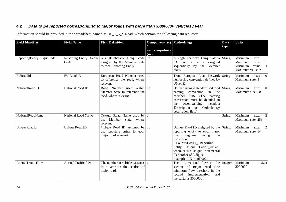
.2 Data to be reported corresponding to Major roads with more than 3.000.000 vehicles / year
Information should be provided in the spreadsheet named as DF_1_5_MRoad, which contain the following data requests:
Field Identifier Field Name Field Definition Compulsory (c) / not compulsory (nc)
Methodology Data type
Units
ReportingEntityUniqueCode Reporting Entity Unique Code
A single character Unique code assigned by the Member State to each Reporting Entity.
nc A single character Unique alpha ID from a to z assigned sequentially by the Member State.
String Minimum size: 1 Maximum size: 1 Minimum value: a Maximum value: z
EURoadId EU Road ID European Road Number used to reference the road, where relevant.
nc Trans European Road Network numbering convention defined by UNECE.
String Minimum size: 0 Maximum size: 4
NationalRoadID National Road ID Road Number used within Member State to reference the road, where relevant.
nc Defined using a standardised road naming convention in the Member State (The naming convention must be detailed in the accompanying metadata 'Description' or 'Methodology description' field).
String Minimum size: 0 Maximum size: 50
NationalRoadName National Road Name Textual Road Name used by the Member State, where relevant.
c String Minimum size: 2 Maximum size: 255
UniqueRoadId Unique Road ID Unique Road ID assigned by the reporting entity to each major road segment.
nc Unique Road ID assigned by the reporting entity to each major road segment using the convention '<CountryCode>_<Reporting Entity Unique Code>_rd<x>', where x is a unique incremental ID number of 5 digits. Example: UK_s_rd00027
String Minimum size: 2 Maximum size: 14
AnnualTrafficFlow Annual Traffic flow The number of vehicle passages in a year on the section of major road.
c The bi-directional flow on the section of major road (the minimum flow threshold in the second implementation and thereafter is 3000000).
Integer Minimum size: 3000000
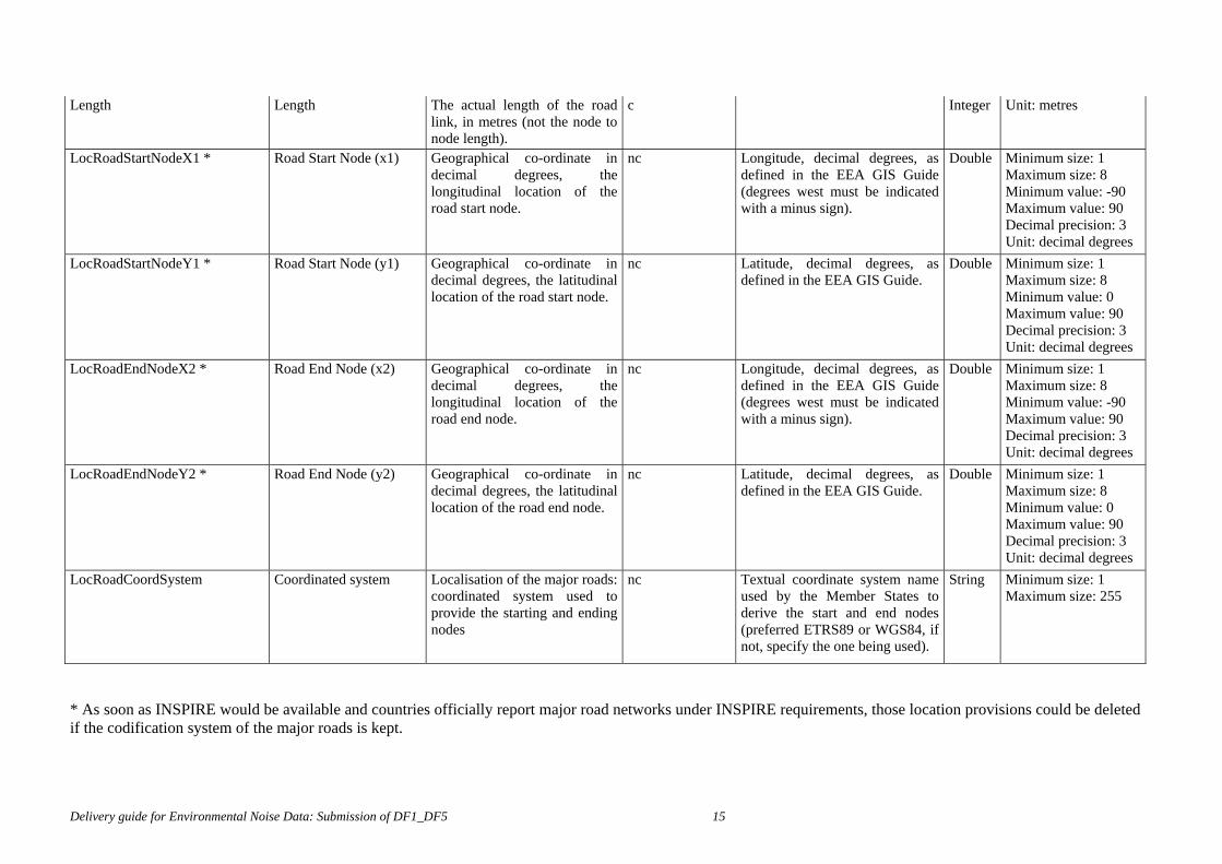
Length Length The actual length of the road
link, in metres (not the node to node length).
c Integer Unit: metres
LocRoadStartNodeX1 * Road Start Node (x1) Geographical co-ordinate in decimal degrees, the longitudinal location of the road start node.
nc Longitude, decimal degrees, as defined in the EEA GIS Guide (degrees west must be indicated with a minus sign).
Double Minimum size: 1 Maximum size: 8 Minimum value: -90 Maximum value: 90 Decimal precision: 3 Unit: decimal degrees
LocRoadStartNodeY1 * Road Start Node (y1) Geographical co-ordinate in decimal degrees, the latitudinal location of the road start node.
nc Latitude, decimal degrees, as defined in the EEA GIS Guide.
Double Minimum size: 1 Maximum size: 8 Minimum value: 0 Maximum value: 90 Decimal precision: 3 Unit: decimal degrees
LocRoadEndNodeX2 * Road End Node (x2) Geographical co-ordinate in decimal degrees, the longitudinal location of the road end node.
nc Longitude, decimal degrees, as defined in the EEA GIS Guide (degrees west must be indicated with a minus sign).
Double Minimum size: 1 Maximum size: 8 Minimum value: -90 Maximum value: 90 Decimal precision: 3 Unit: decimal degrees
LocRoadEndNodeY2 * Road End Node (y2) Geographical co-ordinate in decimal degrees, the latitudinal location of the road end node.
nc Latitude, decimal degrees, as defined in the EEA GIS Guide.
Double Minimum size: 1 Maximum size: 8 Minimum value: 0 Maximum value: 90 Decimal precision: 3 Unit: decimal degrees
LocRoadCoordSystem Coordinated system Localisation of the major roads: coordinated system used to provide the starting and ending nodes
nc Textual coordinate system name used by the Member States to derive the start and end nodes (preferred ETRS89 or WGS84, if not, specify the one being used).
String Minimum size: 1 Maximum size: 255
* As soon as INSPIRE would be available and countries officially report major road networks under INSPIRE requirements, those location provisions could be deleted if the codification system of the major roads is kept.
Delivery guide for Environmental Noise Data: Submission of DF1_DF5 15
4
16 ETC/ACM Technical Paper 2017
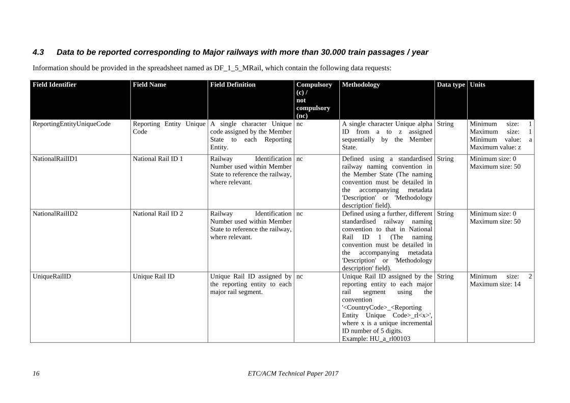
.3 Data to be reported corresponding to Major railways with more than 30.000 train passages / year
Information should be provided in the spreadsheet named as DF_1_5_MRail, which contain the following data requests:
Field Identifier Field Name Field Definition Compulsory (c) / not compulsory (nc)
Methodology Data type Units
ReportingEntityUniqueCode Reporting Entity Unique Code
A single character Unique code assigned by the Member State to each Reporting Entity.
nc A single character Unique alpha ID from a to z assigned sequentially by the Member State.
String Minimum size: 1 Maximum size: 1 Minimum value: a Maximum value: z
NationalRailID1 National Rail ID 1 Railway Identification Number used within Member State to reference the railway, where relevant.
nc Defined using a standardised railway naming convention in the Member State (The naming convention must be detailed in the accompanying metadata 'Description' or 'Methodology description' field).
String Minimum size: 0 Maximum size: 50
NationalRailID2 National Rail ID 2 Railway Identification Number used within Member State to reference the railway, where relevant.
nc Defined using a further, different standardised railway naming convention to that in National Rail ID 1 (The naming convention must be detailed in the accompanying metadata 'Description' or 'Methodology description' field).
String Minimum size: 0 Maximum size: 50
UniqueRailID Unique Rail ID Unique Rail ID assigned by the reporting entity to each major rail segment.
nc Unique Rail ID assigned by the reporting entity to each major rail segment using the convention '<CountryCode>_<Reporting Entity Unique Code>_rl<x>', where x is a unique incremental ID number of 5 digits. Example: HU_a_rl00103
String Minimum size: 2 Maximum size: 14
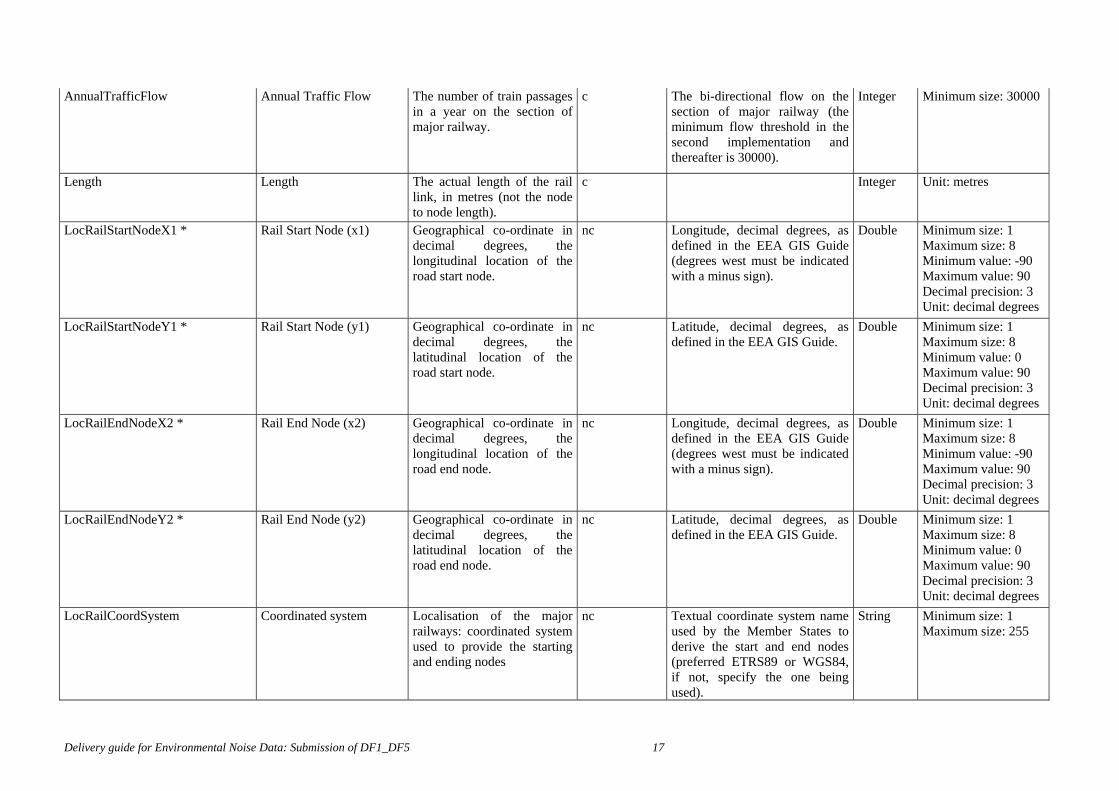
AnnualTrafficFlow Annual Traffic Flow The number of train passages
in a year on the section of major railway.
c The bi-directional flow on the section of major railway (the minimum flow threshold in the second implementation and thereafter is 30000).
Integer Minimum size: 30000
Length Length The actual length of the rail link, in metres (not the node to node length).
c Integer Unit: metres
LocRailStartNodeX1 * Rail Start Node (x1) Geographical co-ordinate in decimal degrees, the longitudinal location of the road start node.
nc Longitude, decimal degrees, as defined in the EEA GIS Guide (degrees west must be indicated with a minus sign).
Double Minimum size: 1 Maximum size: 8 Minimum value: -90 Maximum value: 90 Decimal precision: 3 Unit: decimal degrees
LocRailStartNodeY1 * Rail Start Node (y1) Geographical co-ordinate in decimal degrees, the latitudinal location of the road start node.
nc Latitude, decimal degrees, as defined in the EEA GIS Guide.
Double Minimum size: 1 Maximum size: 8 Minimum value: 0 Maximum value: 90 Decimal precision: 3 Unit: decimal degrees
LocRailEndNodeX2 * Rail End Node (x2) Geographical co-ordinate in decimal degrees, the longitudinal location of the road end node.
nc Longitude, decimal degrees, as defined in the EEA GIS Guide (degrees west must be indicated with a minus sign).
Double Minimum size: 1 Maximum size: 8 Minimum value: -90 Maximum value: 90 Decimal precision: 3 Unit: decimal degrees
LocRailEndNodeY2 * Rail End Node (y2) Geographical co-ordinate in decimal degrees, the latitudinal location of the road end node.
nc Latitude, decimal degrees, as defined in the EEA GIS Guide.
Double Minimum size: 1 Maximum size: 8 Minimum value: 0 Maximum value: 90 Decimal precision: 3 Unit: decimal degrees
LocRailCoordSystem Coordinated system Localisation of the major railways: coordinated system used to provide the starting and ending nodes
nc Textual coordinate system name used by the Member States to derive the start and end nodes (preferred ETRS89 or WGS84, if not, specify the one being used).
String Minimum size: 1 Maximum size: 255
Delivery guide for Environmental Noise Data: Submission of DF1_DF5 17
* As soon as INSPIRE would be available and countries officially report major railways networks under INSPIRE requirements, those location provisions could be deleted if the codification system of the major railways is kept.
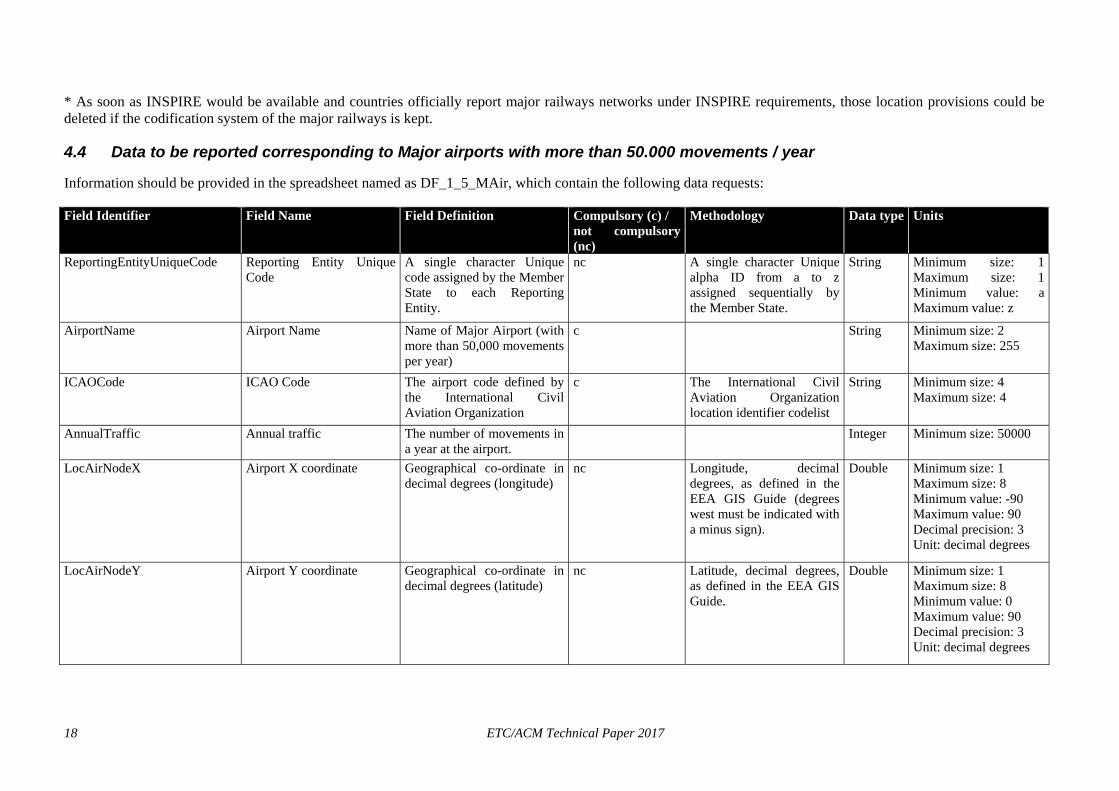
4.4 Data to be reported corresponding to Major airports with more than 50.000 movements / year
Information should be provided in the spreadsheet named as DF_1_5_MAir, which contain the following data requests:
Field Identifier Field Name Field Definition Compulsory (c) / not compulsory (nc)
Methodology Data type Units
ReportingEntityUniqueCode Reporting Entity Unique Code
A single character Unique code assigned by the Member State to each Reporting Entity.
nc A single character Unique alpha ID from a to z assigned sequentially by the Member State.
String Minimum size: 1 Maximum size: 1 Minimum value: a Maximum value: z
AirportName Airport Name Name of Major Airport (with more than 50,000 movements per year)
c String Minimum size: 2 Maximum size: 255
ICAOCode ICAO Code The airport code defined by the International Civil Aviation Organization
c The International Civil Aviation Organizatiolocation identifier codelist
n String Minimum size: 4
Maximum size: 4
AnnualTraffic Annual traffic The number of movements in a year at the airport.
Integer Minimum size: 50000
LocAirNodeX Airport X coordinate Geographical co-ordinate in decimal degrees (longitude)
nc Longitude, decimal degrees, as defined in the EEA GIS Guide (degrees west must be indicated with a minus sign).
Double Minimum size: 1 Maximum size: 8 Minimum value: -90 Maximum value: 90 Decimal precision: 3 Unit: decimal degrees
LocAirNodeY Airport Y coordinate Geographical co-ordinate in decimal degrees (latitude)
nc Latitude, decimal degrees, as defined in the EEA GIS Guide.
Double Minimum size: 1 Maximum size: 8 Minimum value: 0 Maximum value: 90 Decimal precision: 3 Unit: decimal degrees
18 ETC/ACM Technical Paper 2017
Delivery guide for Environmental Noise Data: Submission of DF1_DF5 19
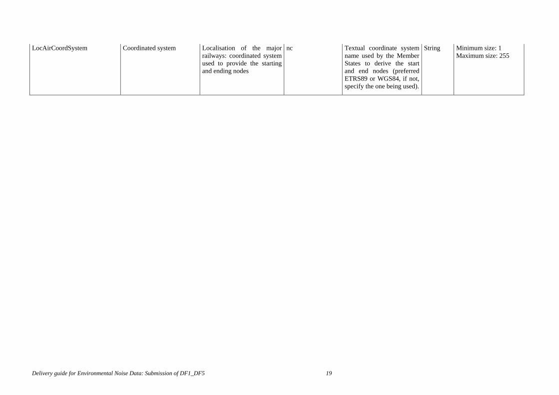
LocAirCoordSystem Coordinated system Localisation of the major railways: coordinated system used to provide the starting and ending nodes
nc Textual coordinate system name used by the Member States to derive the start and end nodes (preferred ETRS89 or WGS84, if not, specify the one being used).
String Minimum size: 1 Maximum size: 255
20 ETC/ACM Technical Paper 2017
5 Spatial information Threedifferent types of information are expected to be delivered in spatial format:
- Polygon information corresponding to the area belonging to the agglomerations that will be mapped.
- Line / polyline information corresponding to the major roads and major railways lines that will be mapped.
- Point (or polygon) information corresponding to the localization of the major airports that will be mapped.
It is not specifically indicated in the END that this information should be provided through spatial files, although it is highly recommended by the EC and by the EEA; in order to facilitate the quality check of the data reported and the inclusion of the information into the European noise database.
In order to harmonise the spatial information to be reported to the European Commission, 4 templates can be downloaded from Reportnet, one per each type of information to be reported.
However, the location of the noise sources is also provided through the excel spreadsheets detailed in the previous section. By doing that, the fulfillment of the END requirements would be considered acceptable (provided that the cells are not filled in with a “-2” value).
EC and EEA will decline responsibilities for not quality checking and therefore, not including into NOISE (Noise Observation and Information Service for Europe) those deliveries not following the specifications and guidelines provided in this annex.
5.1 Noise sources location
Basic demands to be fulfilled when providing the information concerning location in spatial format:
1) Preferred format: SHAPEFILES1
2) Expected entities that will represent locations:
i) POLYGONS in the case of agglomerations’ areas
ii) LINES or POLYLINES in the case of major roads’ and major railways’ central lines
iii) POINTS (or polygons) in the case of major airports (central point of the airport area or the whole polygon occupied by the airport)
2) Coordinate system and projection: ETRS89 - LAEA52 (if another coordinate system is used, it should be specified in the metadata file in order to process the data provided).
Most maps in EEA reports are presented in this CRS (Coordinate Reference System):
1Preferred format is shapefile because (1) major GIS software packages and all the open source desktop GIS support this format ant (2) if can be considered an open format and a de facto standard.
What is referred to as a “shapefile" is actually a set of several files. Four individual files are mandatory to store the core data that comprises a shapefile ("<a>.shp", "<a>.prj", "<a>.dbf" and “<a>.shx”; being <a> the file name, which should be the same for all the files). If a country only provides a single file with the ".shp" extension, this file cannot be used for any purpose, as it is incomplete for distribution. The other three supporting files are required.
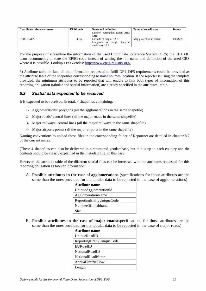
Coordinate reference system EPSG code Name and definition Types of coordinates Datum
ETRS-LAEA 3035
Lambert Azimuthal Equal Area 5210 Latitude of origin: 52 N Longitude of origin (central meridian): 10 E
Map projection in meters ETRS89
For the purpose of streamline the information of the used Coordinate Reference System (CRS) the EEA QC team recommends to state the EPSG-code instead of writing the full name and definition of the used CRS where it is possible. Lookup EPSG-codes: http://www.epsg-registry.org/. 3) Attribute table: in fact, all the information requested to fulfil DF1_DF5 requirements could be provided as the attribute table of the shapefiles corresponding to noise sources location. If the reporter is using the template provided, the minimum attributes to be reported that will enable to link both types of information of this reporting obligation (tabular and spatial information) are already specified in the attributes’ table.
5.2 Spatial data expected to be received
It is expected to be received, in total, 4 shapefiles containing:
1- Agglomerations’ polygons (all the agglomerations in the same shapefile)
2- Major roads’ central lines (all the major roads in the same shapefile)
3- Major railways’ central lines (all the major railways in the same shapefile)
4- Major airports points (all the major airports in the same shapefile)
Naming conventions to upload those files in the corresponding folder of Reportnet are detailed in chapter 8.2 of the current annex.
(These 4 shapefiles can also be delivered in a structured geodatabase, but this is up to each country and the contents should be clearly explained in the metadata file, in this case).
However, the attribute table of the different spatial files can be increased with the attributes requested for this reporting obligation as tabular information:
A. Possible attributes in the case of agglomerations (specifications for those attributes are the same than the ones provided for the tabular data to be reported in the case of agglomerations)
Attribute name UniqueAgglomerationId AgglomerationName ReportingEntityUniqueCode NumberOfInhabitants Size
B. Possible attributes in the case of major roads(specifications for those attributes are the
same than the ones provided for the tabular data to be reported in the case of major roads) Attribute name UniqueRoadID ReportingEntityUniqueCode EURoadID NationalRoadID NationalRoadName AnnualTrafficFlow Length
Delivery guide for Environmental Noise Data: Submission of DF1_DF5 21

22 ETC/ACM Technical Paper 2017
C. Possible attributes in the case of major railways(specifications for those attributes are the same than the ones provided for the tabular data to be reported in the case of major railways)
Attribute name UniqueRailID ReportingEntityUniqueCode NationalRailID1 NationalRailID2 NationalRailName AnnualTrafficFlow Length
D. Possible attributes in the case of major airports(specifications for those attributes are the
same than the ones provided for the tabular data to be reported in the case of major airports) Attribute name ICAOCode ReportingEntityUniqueCode AirportName AnnualTraffic
Each of those shapefiles should be accompanied with the corresponding metadata. More information on metadata for spatial files is detailed in section 7.2.

6 Supplementary information You can provide any other types of information that you think are relevant for consultation purposes (letters, clarification documents, etc). This information will be solely stored, and will not be analysed, so be sure that all the relevant information is provided in the fulfilled templates, in the shapefiles or in the metadata sections accompanying all the files.
It is requested that a short text file (to be used as metadata of the supplementary information provided) would be stored in the same folder detailing, in English:
- The title of the supplementary information
- Language used in the report
- Short description of the information contained in this report (recommended length: from half a page to one page).
Delivery guide for Environmental Noise Data: Submission of DF1_DF5 23
24 ETC/ACM Technical Paper 2017
7 Metadata In order to be able to deal with the data provided, it is very important to provide some information about the data itself.
Therefore, several metadata files are asked to be provided accompanying the information reported. These files should be written down in English.
7.1 Metadata for the tabular data to compile noise sources
The metadata file should contain the following information:
- Title of the excel file that the metadata is referring to
- Reference year: in which year this information has been created and delivered / published
- Responsible organisation: Name of the organisation creating the data
- Contact person: Name of the contact person in the responsible organisation and contact details
- Census year when the population has been calculated
- Year when the traffic flow has been determined
- Constraints of the data being provided.
7.2 Metadata for the shapefiles containing noise sources location
Metadata information that should be associated to each shapefile containing location of noise sources:
- Name of data: title of the data
- Description of data: Which is the content of the data and purpose of its creation
- Coordinate reference system
- Source and methodology – including version of specification on which the compilation is based
- Reference year: in which year this information has been created and delivered / published
- Responsible organisation: Name of the organisation creating the data
- Contact person: Name of the contact person in the responsible organisation and contact details
- Ownership: to whom the data belongs
- Use rights: if the data can be distributed worldwide, restrictions, possibility to use depending on the purpose,…
EEA recommends creatingmetadata for the spatial files according to the INSPIRE implementing rules. Some resources are available in the INSPIRE geoportal like the Metadata editor (http://inspire-geoportal.ec.europa.eu/editor/). Its main purpose is to help create metadata compliant with the INSPIRE Directive (2007/2/EC)2
2http://eur-lex.europa.eu/JOHtml.do?uri=OJ:L:2007:108:SOM:EN:HTML
If using ArcGIS software, it is an option to use the INSPIRE metadata style inside ArcCatalog by going into Customize>ArcCatalog Options> Select Metadata and in the Metadata Style select INSPIRE Metadata Directive.
7.3 Metadata for the Supplementary information
Detailed information provided in section 6.
Delivery guide for Environmental Noise Data: Submission of DF1_DF5 25
26 ETC/ACM Technical Paper 2017
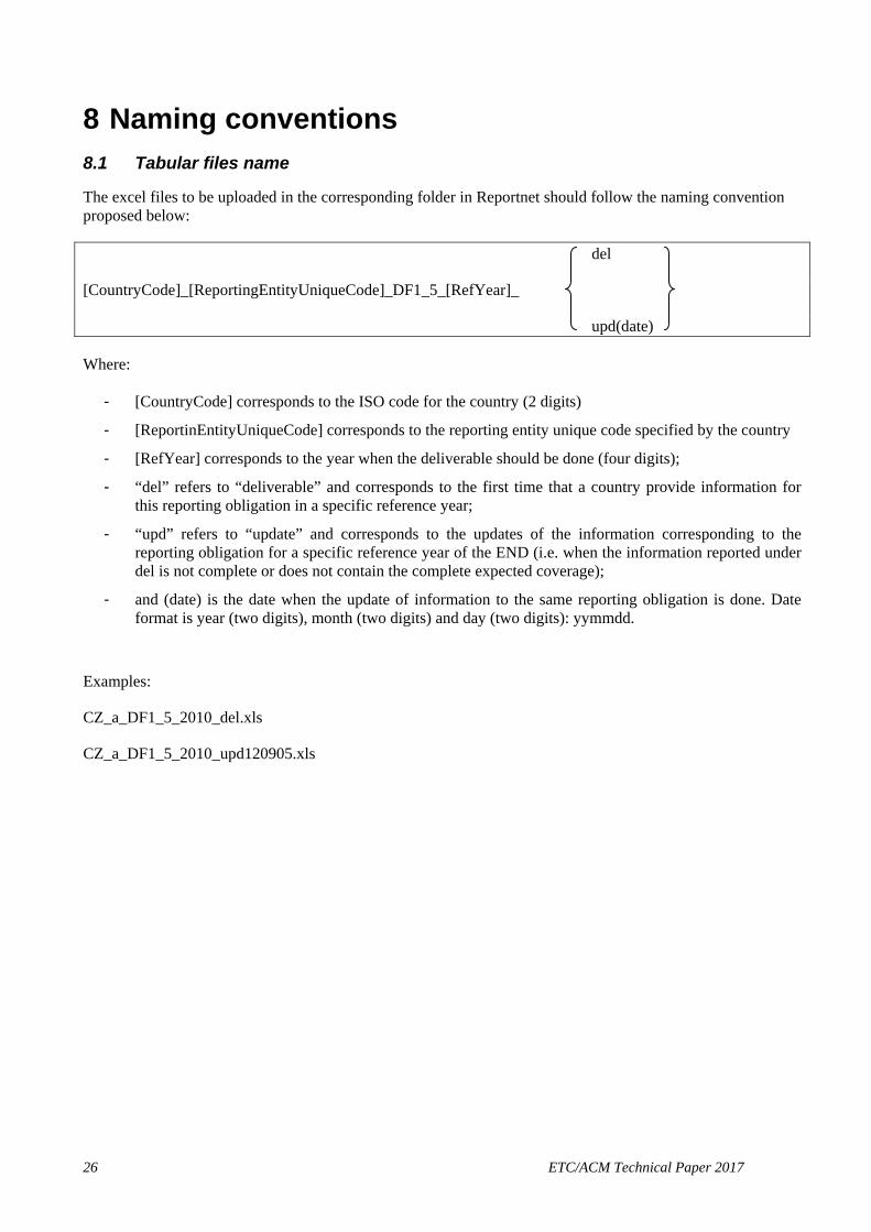
8 Naming conventions 8.1 Tabular files name
The excel files to be uploaded in the corresponding folder in Reportnet should follow the naming convention proposed below:
del
[CountryCode]_[ReportingEntityUniqueCode]_DF1_5_[RefYear]_
upd(date)
Where:
- [CountryCode] corresponds to the ISO code for the country (2 digits)
- [ReportinEntityUniqueCode] corresponds to the reporting entity unique code specified by the country
- [RefYear] corresponds to the year when the deliverable should be done (four digits);
- “del” refers to “deliverable” and corresponds to the first time that a country provide information for this reporting obligation in a specific reference year;
- “upd” refers to “update” and corresponds to the updates of the information corresponding to the reporting obligation for a specific reference year of the END (i.e. when the information reported under del is not complete or does not contain the complete expected coverage);
- and (date) is the date when the update of information to the same reporting obligation is done. Date format is year (two digits), month (two digits) and day (two digits): yymmdd.
Examples:
CZ_a_DF1_5_2010_del.xls
CZ_a_DF1_5_2010_upd120905.xls
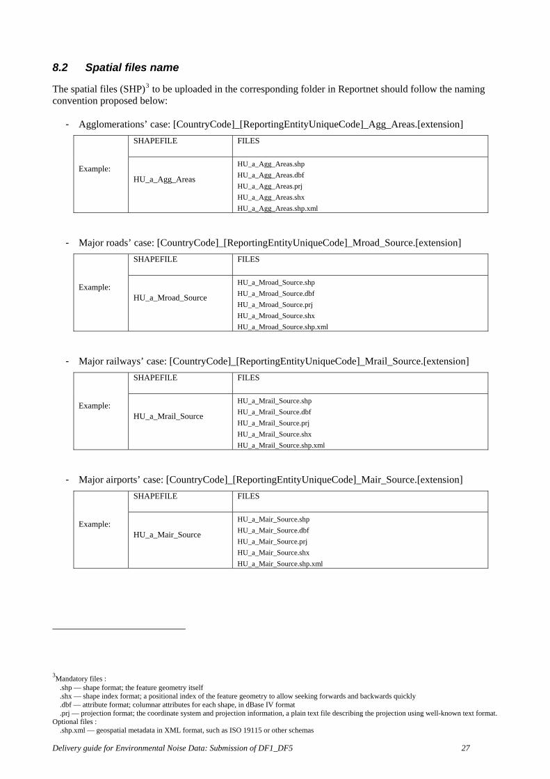
8.2 Spatial files name
The spatial files (SHP)3 to be uploaded in the corresponding folder in Reportnet should follow the naming convention proposed below:
- Agglomerations’ case: [CountryCode]_[ReportingEntityUniqueCode]_Agg_Areas.[extension]
Example:
SHAPEFILE FILES
HU_a_Agg_Areas
HU_a_Agg_Areas.shp HU_a_Agg_Areas.dbf HU_a_Agg_Areas.prj HU_a_Agg_Areas.shx HU_a_Agg_Areas.shp.xml
- Major roads’ case: [CountryCode]_[ReportingEntityUniqueCode]_Mroad_Source.[extension]
Example:
SHAPEFILE FILES
HU_a_Mroad_Source
HU_a_Mroad_Source.shp HU_a_Mroad_Source.dbf HU_a_Mroad_Source.prj HU_a_Mroad_Source.shx HU_a_Mroad_Source.shp.xml
- Major railways’ case: [CountryCode]_[ReportingEntityUniqueCode]_Mrail_Source.[extension]
Example:
SHAPEFILE FILES
HU_a_Mrail_Source
HU_a_Mrail_Source.shp HU_a_Mrail_Source.dbf HU_a_Mrail_Source.prj HU_a_Mrail_Source.shx HU_a_Mrail_Source.shp.xml
- Major airports’ case: [CountryCode]_[ReportingEntityUniqueCode]_Mair_Source.[extension]
Example:
SHAPEFILE FILES
HU_a_Mair_Source
HU_a_Mair_Source.shp HU_a_Mair_Source.dbf HU_a_Mair_Source.prj HU_a_Mair_Source.shx HU_a_Mair_Source.shp.xml
3Mandatory files : .shp — shape format; the feature geometry itself .shx — shape index format; a positional index of the feature geometry to allow seeking forwards and backwards quickly .dbf — attribute format; columnar attributes for each shape, in dBase IV format .prj — projection format; the coordinate system and projection information, a plain text file describing the projection using well-known text format. Optional files : .shp.xml — geospatial metadata in XML format, such as ISO 19115 or other schemas
Delivery guide for Environmental Noise Data: Submission of DF1_DF5 27

28 ETC/ACM Technical Paper 2017
9 Quality check process The items checked in the data reported are the following ones:
- Items checked in the Reportnet’s QA process:
• data specifications – data types, to ensure that data is within the range defined in the guidelines documents,
• all the mandatory elements have been reported,
• code conventions
• the existence of duplicates in unique codes fields.
- Mandatory data has been filled in with a “-2” value.
- Correspondence of unique codes between different dataflow and/or updates of the same dataflow.
- Correspondence of unique codes between tabular information and spatial information being reported.
- Reporting coverage, to be sure that the information has been provided for all the expected reporting units.
- Coordinate Reference System (CRS) is ETRS89 - LAEA52
- Coordinates of the spatial information are inside the European territory.
- Geometry of the data being provided, either points, lines or polygons, have an acceptable structure and topology (e.g. are polygons closed and lines forming networks linked properly to nodes?)
- Geometric accuracy, coordinate reference system and file format follow specifications.
- Metadata has been provided, including aspects of accuracy, coordinate system, methodology and source. A document listing the requested information is available from http://www.eionet.europa.eu/gis/geographicinformationstandards.html.
More information concerning spatial information can be found in the EEA GIS guide in http://www.eionet.europa.eu/gis/.

![Noise Data Management and Dissemination at EU Level - Núria Blanes [en]](https://static.fdocuments.us/doc/165x107/55620f31d8b42a7d028b4e77/noise-data-management-and-dissemination-at-eu-level-nuria-blanes-en.jpg)