DELIVERING LARGE-SCALE Conservation Results
56
DELIVERING LARGE-SCALE Conservation Results WWF Program Management Standards for Ecoregions and Large Programs
Transcript of DELIVERING LARGE-SCALE Conservation Results

D E L I V E R I N G L A R G E - S C A L E
Conservation ResultsWWF Program Management Standards for Ecoregions and Large Programs

D e l i v e r i n g L a r g e - S c a l e C o n s e r v a t i o n R e s u l t s

D e l i v e r i n g L a r g e - S c a l e C o n s e r v a t i o n R e s u l t s
i
INT
RO
DU
CT
ION
DE
FIN
ED
ES
IGN
IMP
LE
ME
NT
AN
ALY
ZE
& A
DA
PT
SH
AR
E
Produced by: WWF-US Global Support
This document contains materials adapted from other sources. Ownership of these materials is retained bythe original copyright holder. Copyright June 2007 for materials produced by WWF-US Global Support.
D E L I V E R I N G L A R G E - S C A L E
Conservation ResultsWWF Program Management Standards for Ecoregions and Large Programs

D e l i v e r i n g L a r g e - S c a l e C o n s e r v a t i o n R e s u l t s
ii
Foreword Welcome to WWF’s newest Field Guide for planning, managing and monitoring our largest conservation pro-grams. This Guide is your blueprint as you develop strategies, align partners and resources, and deliver resultsin our largest priority programs.
This Guide is based on the WWF Standards of Program Management; a set of guidelines, tools and best practicessanctioned by WWF-I as the principal means by which we will carry out conservation worldwide. WWF creat-ed the Standards from tangible, field-tested tools and practices as well as private-sector program managementexpertise that have been adapted for conservation use.
In response to unprecedented local, national and international threats to our planet’s well being, WWF and theconservation sector are launching larger and far more comprehensive programs that reflect both ecological andsocio-economic needs.
These Network Initiatives, priority places, ecoregions and landscapes are large-scale, multi-level conservationprograms that present huge challenges for program managers who now must: develop coherent strategies; gen-erate more revenue; engage multiple partners; mitigate greater risks; and produce globally significant andmeasurable results.
This is our shared vision of conservation if we are to save our planet. The practices and tools within this FieldGuide can help you achieve this vision. WWF has dedicated itself to supporting your use of this methodologythrough training and direct support as well as the tools, guidance, and best practices you will find within the pagesthat follow.
We wish you all the best in achieving truly large-scale conservation results.
Carter S. Roberts James P. LeapePresident and CEO Director GeneralWWF-US WWF-I
©W
WF
-WW
F-C
anon
/ P
hilip
p G
OE
LTE
NB
OT
H
©W
WF
-WW
F-C
anon
/ J
ean-
Luc
RAY

D e l i v e r i n g L a r g e - S c a l e C o n s e r v a t i o n R e s u l t s
iii
INT
RO
DU
CT
ION
DE
FIN
ED
ES
IGN
IMP
LE
ME
NT
AN
ALY
ZE
& A
DA
PT
SH
AR
E
AcknowledgmentsWe are indebted to the many individuals who provided vision, leadership and intellectual rigor to thedevelopment of large conservation program planning and management, including:
Larry Linden, Advisory Director and former General Partner, Goldman Sachs
Ivan Barkhorn, Managing Director, Redstone Strategy Group
Ed Miller, Partner, IBM Business Consulting Services
Chris Casturo, Chief Executive Officer, Point Management Group
Bill Eichbaum, Vice President and Managing Director, Marine Programs, WWF-US
We are also indebted to the many individuals who helped develop this field guide including:
John Morrison, Director of Measures, Conservation Science Program
Nick Salafsky, Co-Director, Foundations of Success.
This document contains materials adapted from other sources. Ownership of these materials is retainedby the original copyright holder.
This Field Guide and the tools, guidance and best practices reflected therein, were generouslyfunded by grants from:
Gordon and Betty Moore Foundation U.S. Agency for International DevelopmentOffice of Economic Growth, Agriculture, and Trade
This publication was made possible by the generous support of the American people through the United States Agency forInternational Development (USAID) and The Gordon and Betty Moore Foundation. The contents are the responsibility of WorldWildlife Fund and do not necessarily reflect the views of The Moore Foundation, USAID or the United States Government.

D e l i v e r i n g L a r g e - S c a l e C o n s e r v a t i o n R e s u l t s
iv
INT
RO
DU
CT
ION
DE
FIN
ED
ES
IGN
IMP
LE
ME
NT
AN
ALY
ZE
& A
DA
PT
SH
AR
E
Table of Contents Introduction............................................................................................................1
I. What are Large Conservation Programs? .....................................................................1
II. Origin and Benefits of Large Program Management.....................................................3
III. How to Use this Field Guide..........................................................................................3
IV. Overarching Principles and Tips for Users ...................................................................4
1 Define.....................................................................................................................5
1.1 Team Composition and Operations ...............................................................................5
1.2 Scope and Vision...........................................................................................................8
1.3 Targets .........................................................................................................................11
1.4 Context and Threats ....................................................................................................13
2 Design .................................................................................................................18
2.1 Action Plan: Strategies, Goals, Objectives and Activities...........................................18
2.2 Monitoring Plan............................................................................................................22
2.3 Operational Plan ..........................................................................................................25
3 Implement ......................................................................................................33
3.1 Workplans and Budgets...............................................................................................33
3.2 Fund-raising and Sustainable Financing .....................................................................35
3.3 Capacity Building .........................................................................................................38
3.4 Partnerships.................................................................................................................39
4 Analyze and Adapt ...............................................................................41
5 Share ....................................................................................................................46
Appendix ..................................................................................................................48
Full List of Steps and Project/Program Cycle......................................................................48

D e l i v e r i n g L a r g e - S c a l e C o n s e r v a t i o n R e s u l t s
1
IntroductionThis Field Guide provides a broad overview oflarge conservation program management tech-niques for field conservation practitioners. Itoffers tools and guidelines for planning, imple-menting and monitoring conservationprograms, and directs the user to more detailedguidance, tools and examples online.
The principal users of this Field Guide areNetwork Initiative and priority program direc-tors, ecoregion and landscape coordinators,other field conservation staff, and governmentand foundation managers engaged in large-scale or highly complex conservation programs.
I. What are Large Conservation Programs?Large conservation programs are long-term, complex initiatives that typically involve vast areas, big budgets,multiple donors, one or more countries, several partner organizations, and include a significant sustainable livelihoods component.
This Field Guide is intended to support conservation work on large programs including Network Initiatives, pri-ority programs, ecoregions, landscapes, ecological hotspots, protected area networks, and other large terrestrial,freshwater, coastal, or marine areas.
Large Conservation Program Characteristics
Program Characteristic Typical Large Program
Total Budget $1 million or more
Duration 5-10 years to over 50 years
Countries Often more than one
Strategic Partners Often more than one
Stakeholders Many diverse interests
Major Donors Often more than one
Programmatic Focus Conservation and sustainable livelihoods combined
Complexity and Integration Highly-linked local, national, regional and global approaches
INT
RO
DU
CT
ION
DE
FIN
ED
ES
IGN
IMP
LE
ME
NT
AN
ALY
ZE
& A
DA
PT
SH
AR
E
©W
WF
-Can
on /
NE
YR
ET
& B
EN
AS
TAR

D e l i v e r i n g L a r g e - S c a l e C o n s e r v a t i o n R e s u l t s
2
Reforestation in Terai Arc Landscape
Large-scale, $200 million, 50-year program to restore forestedwildlife corridors and habitat in the Terai Arc Landscape. Thislandscape spans southern Nepal, Northern India and Bhutan, andincludes extensive provisions for community forest managementand sustainable livelihoods in addition to wildlife protection.
©W
WF
-Can
on /
NE
YR
ET
& B
EN
AS
TAR
Establishing Amazon Region Protected Areas
Establishment, consolidation and management of 67 new protected areasacross the heart of the Brazilian Amazon, covering a land area larger thanthe U.S. National Park System. The Amazon Region Protected Areas(ARPA) program is led by the Brazilian government, an independent trustfund (Funbio), the World Bank, WWF, and other partners.
©W
WF
-Can
on /
Nig
el D
ICK
INS
ON
Sustainable Protection of the Mesoamerican Reef Ecoregion
Sustainable fisheries practices, extensive protected area network, andimprovement of upland water quality entering the reef system are keystrategies in this program, managed by four countries (Belize,Guatemala, Honduras and Mexico), an independent trust fund (MARFund), WWF, TNC and other partners.
©W
WF
-Can
on /
Ant
hony
B.R
ATH
Establishing and Protecting Congo TRIDOM Landscape
Long-term conservation within the Tri-National Dja-Odzala-Minkebe(TRIDOM) area of the Congo Basin rain forest and improvement of locallivelihoods through sustainable resource use are key strategies for this verylarge program covering parts of Cameroon, Congo and Gabon, and involvingmany public and private sector, NGO and local community stakeholders.
©W
WF
-Can
on /
Tim
othy
GE
ER
Large Conservation Program Examples
The conservation practices used in this Field Guide draw heavily upon real field examples. Most of the exam-ples used in this Guide refer to the following six conservation programs.

D e l i v e r i n g L a r g e - S c a l e C o n s e r v a t i o n R e s u l t s
3
II. Origin and Benefits of Large Program ManagementLarge-scale conservation programs are not new. Nonetheless, the past decade has seen increasing efforts to con-serve land at the ecoregional — or larger — level because experience demonstrates that smaller, isolated protectedareas in many cases cannot support viable populations of key species or intact ecosystems over the long term.
As ecoregion-level programs have proliferated, so to has the demand for large program management techniquesto plan, implement and monitor progress at this scale. The tools, processes and examples in this Guide have beendeveloped from both practical field conservation experience and private sector expertise, and are adapted for usein a large conservation setting.
III. How to Use this Field GuideThe Field Guide follows the WWF Standards for Project and ProgramManagement, but with special emphasis on applying the Standards tolarge-scale conservation programs.
The WWF Standards are in five Steps: Define; Design;Implement; Analyze; and Share. A Resource Chart at the begin-ning of each section of this Guide has linkable lists of outputs,guidelines, tools and examples. See the Appendix for a com-plete list of steps and sub-steps.
A detailed overview of the WWF Standards, this Field Guide, and all associated resources are available atwww.panda.org/standards. If you experience trouble with anylinks, please contact [email protected].
INT
RO
DU
CT
ION
DE
FIN
ED
ES
IGN
IMP
LE
ME
NT
AN
ALY
ZE
& A
DA
PT
SH
AR
E
Sustainable Fisheries and Wildlife Populations in the Bering Sea
Two countries (Russia and US) and many NGOs collaborate on thishuge and intensive effort to ensure conservation of the Bering SeaEcoregion’s diverse populations of invertebrates, fish, birds, marinemammals and people through strategies focusing on threats posed bycommercial fishing, marine shipping and climate change.
©W
WF
-Can
on /
Kev
in S
CH
AF
ER
Sustainable Fisheries Management for Gulf of California Ecoregion
The government and many NGO and donor partners collaborate inreducing the impact of unsustainable fishing practices on the Gulf ofCalifornia’s many endemic and endangered species, a humanpopulation of nearly 9 million, and a fishery that generates more than50 percent of Mexico’s wild-caught marine resources.
©W
WF
-Can
on /
Gus
tavo
YB
AR
RA

D e l i v e r i n g L a r g e - S c a l e C o n s e r v a t i o n R e s u l t s
4
IV. Overarching Principles and Tips for UsersThe following overarching principles and tips will help guide your progress through the WWF Standards forProject and Program Management.
Work within key organizational directives
Within WWF, our conservation work is guided by — and often must adhere to — certain organizationaldirectives. These include: the WWF-NL StrategicPrinciples; the WWF-US integrated local-to-globalstrategy; and WWF-I principles guiding our work inecoregions or in the new Network Initiatives. Some ofthese are described briefly in Step 2.1. It is important indeveloping your local strategies that you are aware ofthese broader organizational directives and adjust yourplans accordingly.
Work with Indigenous Peoples
From the first step of organizing your planning teamthrough developing and carrying out your conservationstrategies, be sure to engage the indigenous peoples wholive in, use or depend on lands and resources that are thefocus of your program, or who may be affected byprogram activities. Refer to WWF's Indigenous PeoplesPolicy for specific standards and to the WWF guideMainstreaming WWF Principles on Indigenous Peoplesand Conservation for guidance on engaging indigenouscommunities and organizations in your planning process.
Leverage previous work
As you consider using the Steps in this Guide, you do notneed to reinvent previously completed spatialassessments, targets, strategies, action plans, financialplans or other outputs. Use this Field Guide to identifygaps in the work completed to date, and identify theappropriate entry point in the planning, implementation ormonitoring process for your program.
Tailor your tools
The tools presented in this guide are proven managementtechniques that have been tested and refined with WWFfield experience. However, we encourage tailoring therecommended tools within any given step to your specificprogram and circumstances. As you will see, almost allthe tools shown in the examples have been modified toaccommodate specific program needs.
Work on more than one step at a time
Although the steps and activities in this Guide arepresented in linear order (step 1.1 through 5.4), in actualpractice you will find that it makes more sense to dosome steps out of order, or at the same time you arecompleting other steps. The Guide notes when fullycompleting one step is a prerequisite for starting another.
Note both spatial and strategic considerations
As you develop your vision, targets, threats assessment,strategies, action plans and monitoring indicators, keep inmind that large programs have spatial considerations thatneed to be addressed and mapped. Having access togood GIS support and developing good maps of yourregion’s targets, threats and strategies is essential toachieving great conservation results.

D e l i v e r i n g L a r g e - S c a l e C o n s e r v a t i o n R e s u l t s
5
STEP 1 DefineThe Define Step requires you to specify the basic parameters for your program in preparation for the design workthat will come in Step 2. Specifically, the Define Step involves identifying:� All your stakeholders � Your program team � The program’s geographic scope � A broad vision statement for your program � Your program’s principal biodiversity targets� Your program’s context, including threats and opportunities
All of these elements are highly interlinked, and most program teams go through this as one iterative process.Change the order as your team sees fit, and revisit earlier elements at any time as you complete this step.
1.1 Team Composition and Operations
OverviewThe first task in managing any program is to establish the team responsible for leading the overall design andimplementation for your program. Team members typically include staff within your organization and your clos-est internal and external partners.
To build your team, you will likely draw on the partners, donors and government agencies with whom you workalready. In addition, your team should carry out a stakeholder analysis to ensure you have identified the full poolof stakeholders to engage in your program and draw key stakeholders into your team as needed.
Stakeholders are all the individuals, groups, or institutions—community, government, donor, conservation andnonconservation NGOs, and others—that have an interest in or will be affected by your program. They are theorganizations whose involvement is critical to your success.
A good analysis will consider each stakeholder’s potential role, issues of concern and potential conflicts, and con-sider both powerful stakeholders and those that might be disadvantaged or marginalized by your program’s work.
As you build your team, consider recent changes in partners, funding, local populations, government policies andother conservation efforts, and take into account existing commitments, policies and procedures the programmust follow. You will need broad understanding of these opportunities, limitations and required processes todefine your team and your program.
INT
RO
DU
CT
ION
DE
FIN
ED
ES
IGN
IMP
LE
ME
NT
AN
ALY
ZE
& A
DA
PT
SH
AR
E
D e l i v e r i n g L a r g e - S c a l e C o n s e r v a t i o n R e s u l t s
6
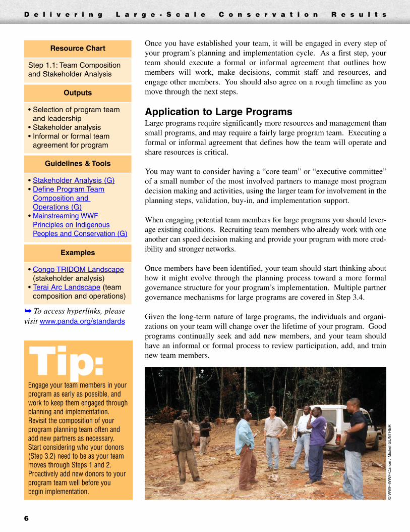
Once you have established your team, it will be engaged in every step ofyour program’s planning and implementation cycle. As a first step, yourteam should execute a formal or informal agreement that outlines howmembers will work, make decisions, commit staff and resources, andengage other members. You should also agree on a rough timeline as youmove through the next steps.
Application to Large ProgramsLarge programs require significantly more resources and management thansmall programs, and may require a fairly large program team. Executing aformal or informal agreement that defines how the team will operate andshare resources is critical.
You may want to consider having a “core team” or “executive committee”of a small number of the most involved partners to manage most programdecision making and activities, using the larger team for involvement in theplanning steps, validation, buy-in, and implementation support.
When engaging potential team members for large programs you should lever-age existing coalitions. Recruiting team members who already work with oneanother can speed decision making and provide your program with more cred-ibility and stronger networks.
Once members have been identified, your team should start thinking abouthow it might evolve through the planning process toward a more formalgovernance structure for your program’s implementation. Multiple partnergovernance mechanisms for large programs are covered in Step 3.4.
Given the long-term nature of large programs, the individuals and organi-zations on your team will change over the lifetime of your program. Goodprograms continually seek and add new members, and your team shouldhave an informal or formal process to review participation, add, and trainnew team members.
➥ To access hyperlinks, pleasevisit www.panda.org/standards
Examples
• Congo TRIDOM Landscape(stakeholder analysis)
• Terai Arc Landscape (teamcomposition and operations)
Guidelines & Tools
• Stakeholder Analysis (G)• Define Program Team
Composition and Operations (G)
• Mainstreaming WWFPrinciples on IndigenousPeoples and Conservation (G)
Outputs
• Selection of program teamand leadership
• Stakeholder analysis• Informal or formal team
agreement for program
Resource Chart
Step 1.1: Team Compositionand Stakeholder Analysis
Tip:Engage your team members in yourprogram as early as possible, andwork to keep them engaged throughplanning and implementation.Revisit the composition of yourprogram planning team often andadd new partners as necessary.Start considering who your donors(Step 3.2) need to be as your teammoves through Steps 1 and 2.Proactively add new donors to yourprogram team well before you begin implementation.
©W
WF
-WW
F-C
anon
/ M
iche
l GU
NT
HE
R

D e l i v e r i n g L a r g e - S c a l e C o n s e r v a t i o n R e s u l t s
7
Example 1: Stakeholder Analysis for Congo TRIDOM LandscapeThis program seeks to ensure long-term conservation within the Tri-National Dja-Odzala-Minkebe (TRIDOM) Landscapeof the Congo Basin rain forest. This very large region covers parts of Cameroon, Congo and Gabon, and involves manypublic and private sector, NGO and local community stakeholders.
The TRIDOM team used the following matrix to assess potential stakeholder involvement. This approach helpedthe team leverage long-standing relationships between organizations. The example that follows shows 4 of the16 stakeholder groups assessed in the overall analysis. For the full grid, see the TRIDOM example link in theStep 1.1 Resource Chart.
TRIDOM Stakeholder Analysis
Example 2: Team Composition for Terai Arc LandscapeThe Terai Arc Landscape (TAL) program in southern Nepal aims to restore degraded wildlife corridors for wildlifedispersal, curb illegal poaching, rehabilitate forests and watersheds, and support community forestry in a 25,000 km2
area settled by 7 million people. The program requires extensive cooperation from the government of Nepal andnumerous nongovernmental, community, private sector and donor organizations.
To address this challenge, a number of key stakeholder organizations organized into a TAL core team to leadplanning and implementation. Several of these organizations had been working for years on sustainable devel-opment and biodiversity conservation in the region. The team has now expanded to 14 organizations, withNepal’s Ministry of Forest and Soil Conservation as the lead. For further information on this team composition,see the TAL example link in the Step 1.1 Resource Chart.
StakeholderInterest in or Relationship to
ProgramResourcesAvailable
Potential Role
Ministry of Water andForest (Cameroon,Congo, Gabon)
Primary program beneficiaries, andmain decision makers for land useand forest management
Human resources atnational and local levels,law enforcement,logistical resources
Crucial partner forimplementation(development of rules, law enforcement)
Local indigenouspopulations(Baka pygmy)
Use part of the program zone forestfor subsistence and participate indevelopment of rules regarding useand access to resources
Deep expertiseregarding forests
Adviser and participant inland-use planning
Logging companiesoperating (or willingto operate) inprogram area zone
Are increasingly interested in green image, and are underpressure to work toward “goodforest management”
Financial resources,logistics, expertise, andinfluence on land-useplanning
Partners in preventing use of logging roads for hunting or poaching
United States Agencyfor InternationalDevelopment
Engaged in supporting TRIDOM management
Financial support,technical assistance,and lobbying capacity
Technical adviser
INT
RO
DU
CT
ION
DE
FIN
ED
ES
IGN
IMP
LE
ME
NT
AN
ALY
ZE
& A
DA
PT
SH
AR
E
D e l i v e r i n g L a r g e - S c a l e C o n s e r v a t i o n R e s u l t s
8
Step 1.2 Scope and Vision
OverviewA program’s scope is its broad geographic or thematic focus. A clearscope sets the rough boundaries for what the program will attempt to do.A program’s scope often includes maps and a description of major ecolog-ical features.
A program’s vision statement describes the ultimate desired state or conditionthat your program seeks to achieve within its scope. A well-formed visionstatement should be visionary, ambitious and relatively brief.
Defining your vision statement is a process that combines scientific analysis,the desired social impact, and inspiration. A straightforward vision statementfocuses your team on the most important challenges and provides the startingplace for all subsequent management efforts (e.g. developing your strategiesand implementing your program).
Application to Large ProgramsWhen scoping large programs, reliable geographic, political and biodiversi-ty mapping is even more critical. For larger programs, your team may needto map existing protected areas, principal landscape and ecoregion bound-aries, and key ecological features including all major biodiversity targets.
Larger programs can have an almost unlimited number of biodiversity tar-gets (Step 1.3). Consult with the WWF-US Conservation Science Programor your organization’s equivalent about the software required to manage thelarge amount of data associated with targets in your region.
Your team may also want to tap into resources and expertise availablethrough universities or other partners to help with expensive and time-intensive mapping and GIS support.
Because the scoping will likely be carried out by staff or outside scientists,it is important to engage your team in the decision to prepare the scope andto get team members’ final review and approval once it is completed.
➥ To access hyperlinks, pleasevisit www.panda.org/standards
Examples
• Mesoamerican ReefEcoregion (scope, vision &spatial assessment)
• Klamath-Siskiyou Ecoregion(spatial assessment)
Guidelines & Tools
• Scope and Vision (G)• Spatial Assessment for
Terrestrial Ecoregions (G)• Spatial Assessment for
Freshwater Ecoregions (G)
Outputs
• Brief scope• Vision statement• Map and/or detailed spatial
assessment if appropriate
Resource Chart
Step 1.2: Scope and Vision
D e l i v e r i n g L a r g e - S c a l e C o n s e r v a t i o n R e s u l t s
9
If your program involves many partners, it is also particularly important that the vision statement be formallydrafted, reviewed and approved as a group. This will help ensure team members’ support for program planningand implementation.
Large programs by nature involve balancing biodiversity goals with human needs and impacts. The vision state-ment for a large program should acknowledge the balance of conservation goals with ensuring sustainablelivelihoods and other social goals.
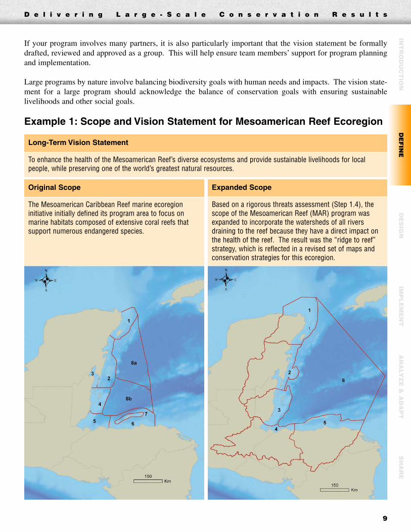
Example 1: Scope and Vision Statement for Mesoamerican Reef Ecoregion
INT
RO
DU
CT
ION
DE
FIN
ED
ES
IGN
IMP
LE
ME
NT
AN
ALY
ZE
& A
DA
PT
SH
AR
E
Long-Term Vision Statement
To enhance the health of the Mesoamerican Reef’s diverse ecosystems and provide sustainable livelihoods for localpeople, while preserving one of the world’s greatest natural resources.
Original Scope
The Mesoamerican Caribbean Reef marine ecoregioninitiative initially defined its program area to focus onmarine habitats composed of extensive coral reefs thatsupport numerous endangered species.
Expanded Scope
Based on a rigorous threats assessment (Step 1.4), thescope of the Mesoamerican Reef (MAR) program wasexpanded to incorporate the watersheds of all riversdraining to the reef because they have a direct impact onthe health of the reef. The result was the “ridge to reef”strategy, which is reflected in a revised set of maps andconservation strategies for this ecoregion.

D e l i v e r i n g L a r g e - S c a l e C o n s e r v a t i o n R e s u l t s
10
Example 2: Scope and Vision for Terai Arc Landscape
50-Year Vision Statement
To conserve the biodiversity, forest, soils and watersheds of the Terai Arc Landscape (TAL) to ensure the ecological,economic and sociocultural integrity of the region.
Scope
The TAL program vision will be achievedby reconnecting 11 protected areasthrough corridors (including three majorNepal-India transboundary corridors) intoa single functioning landscape.Restoration of these areas will facilitatethe dispersal and genetic exchange ofwildlife populations and ensure the long-term survival of endangered species. TheTerai Arc Landscape supports almost 7million people in Nepal alone, andconsists of government-managed forests,community forests, protected areas andbuffer zones.
©W
WF
-Can
on /
Jam
es W
.TH
OR
SE
LL

Step 1.3 Targets
OverviewBiodiversity targets (sometimes called focal conservation targets, or targetsfor short) are the biodiversity features of a place that a conservation pro-gram uses to focus actions and monitor progress. Targets can be species,groups of species, ecological systems such as habitats, or even ecologicalprocesses such as hydrology or pollination.
As your team carries out a full spatial assessment of your program area, youwill identify a wide range of targets of interest in your region. Before youdevelop strategies and actions (in the next steps of these Standards), yourteam will identify a smaller set of strategic targets. Often, you can do bothin the same process.
As you establish targets, you should also identify key ecological attributes(KEAs) to help measure the status of each target. These KEAs are aspectsof the target’s biology that if missing or altered, would lead to the loss ofthat target over time.
For example, the KEA for salmon might be the population size of salmonreturning to a river to spawn. This attribute will become the basis for meas-ures of the target’s health.
Application to Large ProgramsAny larger program such as a landscape, ecoregion or larger, could yielddozens if not hundreds of potential targets. Therefore it is critical that yourteam be disciplined as it narrows this pool to have a limited number that canrepresent the entire assemblage of biodiversity at your site.
A good number to shoot for is 8 to 10 targets. You will then use these tar-gets to plan your conservation strategies and monitoring. Narrowing andagreeing on this narrow set of strategic targets requires a careful blendingof expert biological knowledge with managerial pragmatism.
➥ To access hyperlinks, pleasevisit www.panda.org/standards
Examples
• Bering Sea Ecoregion (targets &key ecological attributes)
• Terai Arc Landscape (targets)
Guidelines & Tools
• Targets (G)
Outputs
• Selection of a limited number ofbiodiversity or thematic targets
• A brief explanation of why eachtarget was chosen
• Identification of key ecologicalattributes for each target
Resource Chart
Step 1.3: Targets
D e l i v e r i n g L a r g e - S c a l e C o n s e r v a t i o n R e s u l t s
11
INT
RO
DU
CT
ION
DE
FIN
ED
ES
IGN
IMP
LE
ME
NT
AN
ALY
ZE
& A
DA
PT
SH
AR
E
Tip:Narrow your key targets to 8-10that you will then use to definegoals, strategies and resultsindicators under Step 2. Themore targets your team chooses,the greater the detail (and work)in the steps that follow.

D e l i v e r i n g L a r g e - S c a l e C o n s e r v a t i o n R e s u l t s
12
In carrying out your detailed spatial assessment, your team can make use of decision support software (such asMARXAN or C-PLAN) that can accommodate an almost unlimited number of targets. This maximizes the use ofavailable information. The WWF-US Conservation Science Program or other local GIS specialists can assist you.
Your team will then select a limited number of strategic targets from this pool to represent the full suite of bio-diversity in your program. Establishing clear strategic targets helps to identify the program’s desiredconservation results, focus actions toward these results, and develop monitoring indicators.
Example 1: Biodiversity Targets for Bering Sea EcoregionThe Bering Sea team originally identified 28 targets, which quickly proved too many for the program to focuson directly. Using a rigorous process, the team nested the original targets into a manageable nine targets intend-ed to represent the full suite of biodiversity in the ecoregion. Each final target was chosen because itsconservation will also conserve other important elements of biodiversity in the region. Three of the new targetsare summarized in the following chart. For the full list, see the Bering Sea Ecoregion example link in the Step1.3 Resource Chart.
Bering Sea Ecoregion Targets
New Target (& Type)
Nested Targets Conservation ImportanceKey Ecological
Attributes
Seabirds(group ofspecies)
• Cormorant• Kittiwake• Murre
These species represent a wide rangeof other seabirds and forage fishbecause they each feed in a differentarea: cormorants near shore,kittiwakes at the shelf break, and murres over the shelf.
• Combined long-termmeans (5-year rollingaverage) forproductivity andpopulation
Southern BeringSea Pinnipeds(group ofspecies)
• Northern Fur Seal
• Stellar Sea Lion
• Harbor Seal
Conservation of these top levelpredators represents conservation ofBering Sea forage and pelagic fishpopulations.
• Prey availability• Population size and
dynamics
Sea IceEcosystem(habitat)
• Walrus• Polar bear• Bowhead whale• Beluga whale• Ringed, spotted, bearded,
and ribbon seals• Spectacled eider
This habitat supports manyendangered species and helpsregulate sea surface temperatures.
• Prey availability• Sea ice habitat integrity• Population size and
dynamics

Step 1.4 Context and Threats
OverviewContext refers to the ecological, social, economic, political and institution-al conditions that affect your program’s biodiversity targets (Step 1.3). Thisstep involves carrying out a thorough situation analysis to understand thecontext of your program. From this, you will be better positioned to designstrategies and actions that will achieve your conservation vision.
Situation analysis involves first determining and ranking direct threats, andthen looking at root causes behind these direct threats. Situation analysisoften uses a graphical tool called a conceptual model that illustrates the rela-tionships between biodiversity targets (targets), threats and interventions.
In short, a good situation analysis helps your team evaluate:� Direct threats� Indirect threats� Enabling conditions� Opportunities and other context
Direct Threats Assessment and RankingA direct threats assessment is a formal exercise that identifies and ranks theconditions that degrade your targets. The ranking process focuses your pro-gram on the highest priority threats with the greatest urgency or likelihoodof success.
This step offers two systems for ranking threats:� Ranking each threat across all your targets (“relative” ranking); � Ranking each threat on each individual target (“absolute” ranking)
Each system uses similar ranking criteria to prioritize threats. The relativeranking system is best used for initial estimations of threats, whereas theabsolute ranking system is better for more detailed analyses. ➥ To access hyperlinks, please
visit www.panda.org/standards
Examples
• Bering Sea Ecoregion(situation analysis,conceptual model &absolute threats ranking)
• Mesoamerican ReefEcoregion (situationanalysis, conceptual model& relative threats ranking)
• Terai Arc Landscape (rootcause analysis)
Guidelines & Tools
• Situation Analysis (G)• Conceptual Models (G)• Threats Ranking (G)
Outputs
• Identification of directthreats affecting each target
• A ranking of the direct threats• Analysis of indirect threats
and opportunities behindeach direct threat
Resource Chart
Step 1.4: Context and Threats
D e l i v e r i n g L a r g e - S c a l e C o n s e r v a t i o n R e s u l t s
13
INT
RO
DU
CT
ION
DE
FIN
ED
ES
IGN
IMP
LE
ME
NT
AN
ALY
ZE
& A
DA
PT
SH
AR
E

D e l i v e r i n g L a r g e - S c a l e C o n s e r v a t i o n R e s u l t s
14
The criteria typically used in the Relative threats assessment include scope,severity, urgency and (optional) irreversibility:� Scope refers to the proportion of the program area or target occurrence like-
ly to be affected by a threat in a given time frame (e.g. the next 10 years)� Severity attempts to quantify or categorize the level of damage to the
target expected in the time frame � Urgency refers to how soon a given threat will likely affect the targets� Irreversibility reflects the ability or likelihood to reverse the impact of a
given threat
The criteria typically used in the Absolute threats assessment include scope,severity and irreversibility. The impact of each threat on each target is ratedon a score of 1 (low) to 4 (very high). These scores are either simply addedor combined (using rule-based systems) to get an overall threat ranking.
Application to Large ProgramsLarge conservation programs in general face a larger number of threats.Therefore, any threats analysis runs the risk of being overly complicatedand confusing. Your team should try to limit analysis to the most importantthreats affecting the region.
Step 1.4 evaluates threats and (in the next section) indirect threats and rootcauses of threats. For larger programs, your team should rank your directthreats before tackling the more complex process of identifying root causes.
Tips:During the threats assessment, youmay discover other threats or issuesthat require more analysis. Be sureto document these as part of yourprogram’s context even if you lacksufficient data to rank them, andinclude them as the focus ofadditional research or analysis.
The process of doing this analysiswith your team is just asimportant—possibly moreimportant—than the final product.This is because the process is whatfocuses your team on the mostimportant targets, threats, and rootcauses in your program. If yourteam gets bogged down evaluatingtoo many targets or threats, thisprocess becomes compromised.
Ber
ing
Sea
map
s pr
epar
ed b
y R
andy
Hag
erst
ein
of T
he N
atur
e C
onse
rvan
cy.
In a large program, it is also important to track the spatial dimension of where threats are occurring since in mostcases they are not uniform over the region.
Example 1: Spatial Occurrence of Threats in Bering Sea EcoregionThe following maps illustrate the locations of two top threats to the biological targets in the Bering SeaEcoregion. For the full set of maps, see the Bering Sea Ecoregion example link in the Step 1.4 Resource Chart.
Areas of Bering Sea Ecoregion threatened by marine invasive species
Areas of Bering Sea Ecoregion threatened by polar bear hunting

D e l i v e r i n g L a r g e - S c a l e C o n s e r v a t i o n R e s u l t s
15
Example 2: Absolute Threat Ranking for Bering Sea EcoregionThe Bering Sea Ecoregion team performed an absolute ranking of threats across each target to identify threatsthat optimize the cost-effectiveness of interventions. For this prioritization, three criteria were used: Scope ofthreat in the Bering Sea Ecoregion; Severity of threat by surface unit; and Irreversibility of threat.
The following table shows summary rankings for 5 of the 14 program-specific threats to the 3 of 9 biodiversitytargets. It also calculates the overall threat rank by target according to compilation rules developed by The NatureConservancy. Based on the analysis, climate change, lack of management data, excessive predation, oil spills andcompetition with fisheries are the threats on which the program should focus effort. For the full table, see theBering Sea Ecoregion example link in the Step 1.4 Resource Chart.
Bering Sea Threat Ranking
Example 3: Relative Threat Ranking for Gulf of California EcoregionThe Gulf of California (GoC) Ecoregion team performed a relative ranking of all threats across all targets to iden-tify threats that optimize the cost-effectiveness of interventions. For this prioritization, three criteria were used:Scope of threat in the GoC Ecoregion; Severity of threat by surface unit; and Urgency of threat. According tothe analysis, artisanal fisheries, industrial fisheries and urban and tourist development are the threats with thegreatest need for attention and the areas on which the program should focus effort.
Gulf of California Relative Threat Ranking
Threat Scope Severity Urgency Total Classification
Artisanal fisheries 10 7 10 27 Very High
Industrial fisheries 8 8 6 22 High
Urban/tourist development 5 10 9 24 High
Aquaculture expansion 4 9 8 21 Medium
Logging 3 3 3 9 Low
Biodiversity Targets Program-specific threats
Seabirds PinnipedsSea Ice
EcosystemOverall
Threat Rank
Climate change High High Very High Very High
Oil spills High Medium Medium High
Competition w/ fisheries High High – High
Introduced predators High – – Medium
Aquaculture – – – Low
Overall Threat Rank High High High Very High
INT
RO
DU
CT
ION
DE
FIN
ED
ES
IGN
IMP
LE
ME
NT
AN
ALY
ZE
& A
DA
PT
SH
AR
E

D e l i v e r i n g L a r g e - S c a l e C o n s e r v a t i o n R e s u l t s
16
Indirect Threats, Root Causes and Opportunities AssessmentOnce you have identified the direct threats, the next step for your team is toevaluate indirect threats and root causes of these indirect threats.
Root cause analysis identifies and explains the key factors that drive biodiver-sity loss, including those factors that interact in complex and not-so-obviousways. These root causes can include indirect threats, opportunities and link-ages to key stakeholders that influence threats and opportunities.
A useful tool to analyze the relationships among biodiversity targets, directthreats, indirect threats, opportunities and stakeholders is a conceptualmodel. You can also simply describe these linkages in writing, but yourteam would benefit from using the diagrammatic illustration derived fromthe conceptual model tool.
The conceptual model illustrates the cause and effect relationships amongthreats, opportunities and your program’s targets. The model visually com-municates your situation and the logic of your program’s strategies andintended results to your team as well as to donors and other constituents.
A conceptual understanding of threats and enabling conditions is often wellinformed by the maps prepared in the spatial assessment. First, detailedmaps allow you to visualize the distribution of threats across the programarea. Second, a detailed threats map allows you to combine many threats(which can be weighted by severity or importance) into a combined multi-level threat map.
Application to Large ProgramsThe greatest challenge in developing a good root cause analysis for a program ofany size is to show enough detail to be useful for decision making, but not somuch detail that your analysis becomes overwhelmingly complicated. Thischallenge is particularly acute in large programs as most encompass a largerarea, more biodiversity targets, and more threats.
One solution to this challenge is to at least initially analyze the root causesbehind each direct threat, rather than trying to think about all the threats atonce. Your team can also limit the analysis to only those threats ranked“high” and “very high.”
Tip:Root cause analysis offers asimple way to identify underlyingindirect threats and causes toprepare a focused strategic plan.The conceptual diagram processis more time consuming, butmore powerful because thediagram visually links indirectthreats and root causes to directthreats and biodiversity targets.
©W
WF
-Can
on /
Gus
tavo
YB
AR
RA
D e l i v e r i n g L a r g e - S c a l e C o n s e r v a t i o n R e s u l t s
17
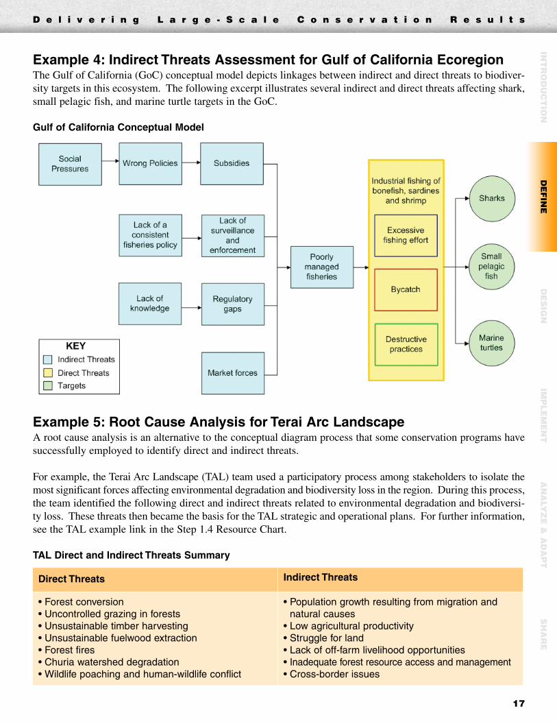
Example 4: Indirect Threats Assessment for Gulf of California EcoregionThe Gulf of California (GoC) conceptual model depicts linkages between indirect and direct threats to biodiver-sity targets in this ecosystem. The following excerpt illustrates several indirect and direct threats affecting shark,small pelagic fish, and marine turtle targets in the GoC.
Gulf of California Conceptual Model
Example 5: Root Cause Analysis for Terai Arc LandscapeA root cause analysis is an alternative to the conceptual diagram process that some conservation programs havesuccessfully employed to identify direct and indirect threats.
For example, the Terai Arc Landscape (TAL) team used a participatory process among stakeholders to isolate themost significant forces affecting environmental degradation and biodiversity loss in the region. During this process,the team identified the following direct and indirect threats related to environmental degradation and biodiversi-ty loss. These threats then became the basis for the TAL strategic and operational plans. For further information,see the TAL example link in the Step 1.4 Resource Chart.
TAL Direct and Indirect Threats Summary
Direct Threats Indirect Threats
• Forest conversion• Uncontrolled grazing in forests• Unsustainable timber harvesting• Unsustainable fuelwood extraction• Forest fires• Churia watershed degradation• Wildlife poaching and human-wildlife conflict
• Population growth resulting from migration andnatural causes
• Low agricultural productivity• Struggle for land• Lack of off-farm livelihood opportunities• Inadequate forest resource access and management• Cross-border issues
INT
RO
DU
CT
ION
DE
FIN
ED
ES
IGN
IMP
LE
ME
NT
AN
ALY
ZE
& A
DA
PT
SH
AR
E

D e l i v e r i n g L a r g e - S c a l e C o n s e r v a t i o n R e s u l t s
18
STEP 2 DesignOnce your team has described the scope, biodiversity targets, threats and context for your program, the next stepis to design specific strategies you will undertake to conserve biodiversity within the program area.
The Design Step has three sections, all of which are tightly linked:� Action Plan in which you set your program’s strategies, goals, objectives and activities � Monitoring Plan in which you will develop performance indicators to track target status and program
progress� Operational Plan that outlines how your program will develop the financial, human and other resources
needed to implement over the long term
Step 2.1 Action Plan: Strategies, Goals, Objectives and Activities
OverviewAs your team moved through Steps 1.3 and 1.4, you began to identify potential strategies using your conceptualmodel and root causes (indirect threats) analyses. In this section you will test and clarify these strategies in theform of specific goals, objectives and activities you will use to achieve conservation results.
This process introduces increasing amounts of detail into your program planning, and allows your team to movefrom the broad program vision into implementation and monitoring. Each goal will have one or even severalobjectives. Each objective will have several activities.
Good action plans also include a timeline and specific outputs or deliverables for your activities—and identifyparties responsible for carrying out activities. This detail gives your team the means to assign and manage finan-cial needs, workplans and monitoring so the program planned will actually be carried out.
GoalsA goal is a formal statement that describes the future desired status of each biodiversity target (Step 1.3) over theterm of your program. Each biodiversity target should have a numerical goal associated with it. It may help tomap numerical goals that are applied to spatial attributes, for example ha or km2 of key habitat types.

➥ To access hyperlinks, pleasevisit www.panda.org/standards
Examples
• Mesoamerican ReefEcoregion (results chains &action plan)
• Terai Arc Landscape (logframe)
Guidelines & Tools
• Action Plan (G)• Results Chains (G)• Logical Framework Analysis (G)• WWF-NL Strategic Principles• WWF-US Overarching Goal
and Strategies
Outputs
• Goals for key biodiversitytargets
• Objectives for threats andopportunities
• Activities for all objectives• Results chains or other
description of assumptions• Goals, objectives, and
activities compiled in youraction plan/logframe
Resource Chart
Step 2.1: Action Plan -Strategies, Goals, Objectivesand Activities
Tip:Preparing an action plan for largeprograms requires a certain levelof negotiation with partners. It isvery important that your programengage its partners in settinggoals, objectives and activitiesthat are acceptable to and feasiblefor all.
The goals you develop should meet the following “SMART” criteria:� Specific� Measurable� Achievable� Results-oriented� Time-limited
To identify goals, your team will determine the desired long-term status ofeach target. Once you have summarized the status in a short sentence, yourteam should ensure each goal meets the SMART criteria.
A second, more formal method for developing goals is to use a processdeveloped by The Nature Conservancy called Viability Analysis. In thisprocess, your team can identify key ecological attributes (Step 1.3) for eachtarget, and determine a status or progress indicator for each attribute.
ObjectivesAn objective is a formal statement of how your program will affect a threator opportunity. Objectives are outcome-oriented and are explicitly linkedto threats or opportunities that affect one or more targets.
A single goal may have multiple objectives linked to it. The examples atthe end of this section illustrate these linkages. As with goals, objectivesshould be SMART.
Your team should set objectives for each direct threat identified in Step 1.4.Your team can also set objectives for key indirect threats or opportunitiesthat affect your threats.
For planning purposes, you may want to limit objectives to those threatsranked “very high” or “high.” Your team needs to make this judgmentbased on the capacity to implement your program (Step 2.3) and its likeli-hood of success.
ActivitiesAn activity is a specific action or task that members of your team willundertake to attain objectives. Each activity is explicitly linked to an objec-tive. A good activity should be explicit and clearly stated so the responsibleparty knows exactly what is expected.
To determine activities, your team should systematically identify theactions required to reduce or eliminate each direct threat. This involveslooking at all factors (root causes, indirect threats and opportunities) thatinfluence your direct threats, and deciding to intervene on any factor offer-ing substantial leverage to mitigate a direct threat.
D e l i v e r i n g L a r g e - S c a l e C o n s e r v a t i o n R e s u l t s
19
INT
RO
DU
CT
ION
DE
FIN
ED
ES
IGN
IMP
LE
ME
NT
AN
ALY
ZE
& A
DA
PT
SH
AR
E
Results chains and logical framework analysis (logframe) are two commonly used tools for identifying activities.Both tools are helpful, but results chains more explicitly link actions, objectives and goals back to your threatsand targets.
1. A results chain is a graphical representation of how your team believes your conservation strategies willlead to the attainment of your vision (Step 1.2). The “chain” depicted in this tool links goals to targets,objectives to direct and indirect threats, and explicit actions to each objective. This tool is used to testwhether each proposed activity in a given strategy will produce the intended result. Results chains also clarify progress and status indicators for all goals and objectives.
2. A logframe summarizes and records your goals, objectives, activities, intended outcomes and monitoring indicators.
Application to Large ProgramsAs you move through Step 2, your team will get into increasing levels of detail at the objective and activity level.It is critical in large programs that your team narrows your target selection (Step 1.3) to 8 to 10 or fewer, and usesyour threats ranking (Step 1.4) to focus on the highest priority threats.
As highlighted in the box below, some large programs require goals, objectives and activities across multiplescales from local to national to global. This integrated approach requires program management, coordination andmonitoring activities to be reflected in the action plan and in the operational plan (Step 2.3).
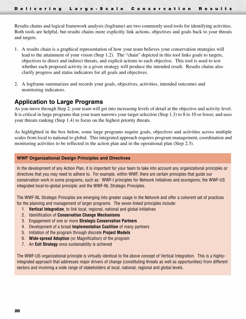
WWF Organizational Design Principles and Directives
In the development of any Action Plan, it is important for your team to take into account any organizational principles ordirectives that you may need to adhere to. For example, within WWF, there are certain principles that guide ourconservation work in some programs, such as: WWF-I principles for Network Initiatives and ecoregions; the WWF-USintegrated local-to-global principle; and the WWF-NL Strategic Principles.
The WWF-NL Strategic Principles are emerging into greater usage in the Network and offer a coherent set of practicesfor the planning and management of larger programs. The seven linked principles include:
1. Vertical Integration, to link local, regional, national and global initiatives2. Identification of Conservation Change Mechanisms3. Engagement of one or more Strategic Conservation Partners4. Development of a broad Implementation Coalition of many partners5. Initiation of the program through discrete Project Models6. Wide-spread Adoption (or Magnification) of the program7. An Exit Strategy once sustainability is achieved
The WWF-US organizational principle is virtually identical to the above concept of Vertical Integration. This is a highly-integrated approach that addresses major drivers of change (constituting threats as well as opportunities) from differentsectors and involving a wide range of stakeholders at local, national, regional and global levels.
D e l i v e r i n g L a r g e - S c a l e C o n s e r v a t i o n R e s u l t s
20

D e l i v e r i n g L a r g e - S c a l e C o n s e r v a t i o n R e s u l t s
21
INT
RO
DU
CT
ION
DE
FIN
ED
ES
IGN
IMP
LE
ME
NT
AN
ALY
ZE
& A
DA
PT
SH
AR
E
Example 1: Goals, Results Chain and Action Plan for Gulf of California Ecoregion The following are four of seven goals that the Gulf of California (GoC) team identified for the program’s biodi-versity targets; one of fifteen strategies; and the results chain associated with that strategy.
Gulf of California Results Chain for Strategy 2.1
The program team used results chains like the one below to identify 15 strategies the program will pursue. Theseresults chains helped produce detailed activities and measurable objectives, a few of which are highlighted below.
Gulf of California Strategy 2.1: Reduction of marine turtle bycatch.
Bycatch in the artisanal fleet has been one of the main factors causing marine turtles (mainly leatherback and green) tobecome almost extinct in the Pacific. This strategy is based on demonstrated effectiveness of circle hooks, communicationof results among fishermen, an exchange program of “J” hooks for circle hooks, and introduction of their daily use.
Gulf of California Program Goals
Reefs and rocky bottoms—20 years from the beginning of the program, the observed values of diversity andabundance of representative fish and benthic organisms (bass, lobster, octopus, sea cucumber) at reefs and rockybottoms of priority sites in the GoC are not significantly different from baseline levels.
Small pelagic fish—20 years from the beginning of the program, the (mean) biomass of small pelagic fishes in the GoCis kept at a minimum of 400,000 tons, allowing its renewal, commercial exploitation, and use as food for other species.
Marine turtles—in 20 years there will be a 10 percent increase in the survival of leatherback and green turtles in theGoC as compared to levels in 2005.
Sharks—in 20 years the abundance of the four main species of pelagic sharks caught in the GoC (Alopias pelagicus,Carcharhinus falciformis, Sphyrna lewini, and Sphyrna zygaena) will be 20 percent more than values in 1998.

Example 2: Logical Framework Analysis for Terai Arc LandscapeThe Terai Arc Landscape (TAL) team used a logical framework (logframe) to summarize goals, objectives, activ-ities, indicators, means of verification and assumptions for its program. The following chart represents part ofthis logframe, although most details were added purely for illustration. For the actual logframe, see the TALexample link in the Step 2.1 Resource Chart.
Terai Arc Landscape Logframe
Step 2.2 Monitoring Plan
OverviewThis step gives your team a set of monitoring indicators for each goal, objective and activity set in your actionplan. You will also develop a process for gathering and assessing data for each of your indicators.
A good indicator has several factors that your team should consider in setting up a monitoring plan. Indicatorsmust be precise, measurable, consistent and unchanging over time, but also sensitive and responsive to changesin the condition being measured.
Goal 2 Restoration and effective management of 764,000 ha of TAL forest by 2014.
Objective 2.1 Support sustainable community forestry plantation by local households through training and technical assistance by 2012.
ActivityMeasurable
IndicatorMeans of Verification Assumptions
Activity 2.2.1:Provide technicaland financialsupport toCommunity ForestUser Groups(CFUGs) andCommunity ForestManagement Groups(CFMGs) by 2010 toreduce forestdegradation.
Ind. 2.1.A:Number of TALhouseholds activelyparticipating (in thepast 6 months) incommunity forestrytraining program.
Data Source: Forest user group databaseData Collection Method: Request fromgovernmentGeographic Scope: TAL forest areas, townships,buffer zones, and corridorsFrequency: SemiannuallyResponsibility: WWF-Nepal
Locals are willingto participate ineducation andtraining sessions.
Ind. 2.1.B: Totalnumber of ha offorest beingmanaged by CFUGsand CFMGs.
Data Source: Forest field reportData Collection Method: Request from governmentGeographic Scope: TAL forest areasFrequency: SemiannuallyResponsibility: WWF-Nepal
Land reformprogram is in place.
D e l i v e r i n g L a r g e - S c a l e C o n s e r v a t i o n R e s u l t s
22
➥ To access hyperlinks, pleasevisit www.panda.org/standards
Examples
• Mesoamerican ReefEcoregion (biological & goal/objective-based activitymonitoring)
• Terai Arc Landscape(partner activity monitoring)
Guidelines & Tools
• Monitoring Plan (G)
Outputs
• Indicators to track progressof each goal, objective, andactivity
• Brief descriptions ofmethods to collect data foreach indicator
• When, where, and by whomeach kind of data will becollected
• Description of how data willbe stored and analyzed
Resource Chart
Step 2.2: Monitoring Plan
Tips:Your team should develop amonitoring plan at the same timeyou develop your action plan (Step2.1) and your operations plan (Step2.3). The actions and indicatorsyou derive are the basis for thebudget or financial modeldeveloped in Step 2.3.
Carefully estimate the full cost ofcollecting baseline data, which isoften much higher than periodicsampling costs required later.Include baseline and all monitoringcosts in your financial model.
Each indicator may require different collection and analysis methods. Themethod you choose for a given indicator needs to be accurate and reliable,but also feasible and cost-effective. A key point is that the most expensivemethods are not always the best.
In general, you want to collect the least amount of information that willallow you to know the status of your biodiversity targets, threats andactions, and enable your team to make sound management decisions. Inpractice, you will need to prioritize which biological, threat-related, finan-cial or activity-based indicators to track based on costs and benefits.
As you prioritize and lay out your monitoring plan, it is recommended thatmost of your investment go toward monitoring goals and objectives. Thisinformation will tell you the most about the status of your biodiversity tar-gets and threats.
Monitoring plans should list each indicator along with how, where (spatialscale and location) and when (time frame and frequency) it will be collect-ed. The plan should also describe how and by whom data will be collected,stored and analyzed.
A complete monitoring plan should also outline how you will collect base-line data (against which all subsequent data will be measured), intermediateand final desired results, monitoring costs and funding sources for monitor-ing (if known).
The details in your action plan will set you up for your monitoring plan. Ifyour goals and objectives meet all the criteria, and you have explicit resultschains or a logframe, your indicators should come directly from this work.
Application to Large ProgramsFor large programs with time frames that can range from 20 to 50 years, itis important to track progress toward long-term goals and objectives at reg-ular intervals. Your team members, the government and donors need toknow your status and results over time.
Long-term change, especially in large, complex programs occurs slowly, soyour team, donors, partners and other stakeholders should be realistic aboutwhen change can be expected. You will need to carefully manage expecta-tions—especially with respect to donors, who very often desire evidence ofshort-term results.
You will likely see progress fairly quickly for shorter-term objectivesaddressing indirect threats or opportunities. You may see results related toyour biodiversity targets (via goals) and threats (via objectives)—but youneed to confirm that changes are due to your program rather than unrelatedevents or forces.
D e l i v e r i n g L a r g e - S c a l e C o n s e r v a t i o n R e s u l t s
23
INT
RO
DU
CT
ION
DE
FIN
ED
ES
IGN
IMP
LE
ME
NT
AN
ALY
ZE
& A
DA
PT
SH
AR
E

Given the number of partners and activities in large programs, it is especially important to assign accountabilityfor work and results. Your monitoring plan, once formally endorsed by team members, should be carried out andperiodically reviewed by a subset of team members within a formal partner governance structure (Step 3.4).
Example 1: Monitoring Plan for Gulf of California EcoregionThe following excerpt from the Gulf of California (GoC) monitoring plan illustrates monitoring details for bothgoals (target-focused) and objectives (threat-focused) for the circle hook strategy highlighted in Step 2.1,Example 1.
Gulf of California Monitoring Plan
Objective 3 By 2012, 90% of the artisanal longline fleet of the GoC will operate with circle hooks.
Indicator Method DateResponsible
EntityPlace
Percentage of boatsusing circle hooks
Inspection of the fleet Starting in 2010 WWF GCP San Felipe, PuertoPeñasco, Mazatlán
Objective 2 By 2010, at least 220,000 circular hooks will have been exchanged for the same number of type “J” hooks in the artisanal longliner fleets in the GoC.
Indicator Method DateResponsible
EntityPlace
Number of “J” hooksexchanged for circlehooks
Regional hookexchange program
Starting in 2010 WWF GCP GoC
Objective 1 By 2009, we will have a proven method to significantly reduce marine turtle bycatch from the artisanal longliner fleets from 12 locations on the Mexican Pacific.
Indicator Method DateResponsible
EntityPlace
Bycatch rates ofmarine turtle
Evaluation trials onboard artisanal fleet
2005-2008 WWF GCP 12 locations
Target Marine Turtles (leatherback and green turtles)
Strategy Reduce marine turtle bycatch.
Goal In 20 years, there will be a 10% increase in the survival of leatherback and green turtles into the GoC compared to 2005 levels.
Indicator Method DateResponsible
EntityPlace
Abundance Index Counting of nestingturtles
Every three years,starting in 2007
Turtle campspersonnel
Baja California Sur and Michoacánturtle camps
D e l i v e r i n g L a r g e - S c a l e C o n s e r v a t i o n R e s u l t s
24

Step 2.3 Operational Plan
An operational plan summarizes the financial, human, and other resourcesnecessary to implement activities and monitoring for your program. Itidentifies where those resources will come from, and the major risks asso-ciated with implementation of your program.
A good operational plan will typically include these four components:� Capacity assessment of human and other resources� Comprehensive financial model reflecting costs and revenues� Risk assessment and mitigation plan� Project lifespan and exit strategy
The size of your program will dictate how many of these steps your teamneeds to address. Smaller, short-term projects with good action and monitor-ing plans can quickly assess capacity needs or risks, and move quickly todeveloping one- to three-year workplans, budgets and proposals under Step 3.
Larger and more complex programs should carry out a rigorous examinationof capacity and resource needs for implementation. As your team scales up tolarger conservation work that entails many years, it is critical to quantify allneeds in a comprehensive financial model that projects long-term costs andsustainable funding requirements.
Human and Other Capacity RequirementsThe term “capacity” refers to all elements needed for your program to scaleup and deliver results. This step examines human, financial, network andother capabilities that are important factors in your success.
The simple assessment tool used in this step will help your team evaluateyour program capacity needs prior to implementation. The tool will helpyou determine to what extent those capacities already exist and simply needto be engaged, and to what extent you will have to fund those capacities orfind them in other places.
➥ To access hyperlinks, pleasevisit www.panda.org/standards
Examples
• Bering Sea Ecoregion(capacity assessment)
Guidelines & Tools
• Operational Plan (G)
• Program CapacityAssessment Template (T)
Outputs
• Estimates of capacity needsand gaps required toimplement your project
Resource Chart
Step 2.3: Operational Plan
Tip:In the process of creating youraction and monitoring plans(Steps 2.1 and 2.2), it is wise todevote some time to beginningthe capacity assessment processwhile your objectives, activitiesand monitoring needs are fresh inyour team members’ minds.
D e l i v e r i n g L a r g e - S c a l e C o n s e r v a t i o n R e s u l t s
25
INT
RO
DU
CT
ION
DE
FIN
ED
ES
IGN
IMP
LE
ME
NT
AN
ALY
ZE
& A
DA
PT
SH
AR
E

D e l i v e r i n g L a r g e - S c a l e C o n s e r v a t i o n R e s u l t s
26
The capacity assessment tool is based on a popular method used in the private sector known as the 7-SFramework (developed by McKinsey). The 7-S Framework focuses on seven areas of capacity: shared goals andvalues, strategies, style, skills, staff, systems and structures.
Because WWF and conservation programs attributes differ from those of the typical private sector enterprise, wehave modified the 7-S Framework into the following categories:� Skills (organizational and individual) � Program partners� Systems (processes, policies and procedures � Network (WWF) and program governance
such as HR, IT, F&A and Ops) � Resources (funding & in-kind)� Management structure and style � Power and influence
Application to Large ProgramsBecause of the dependency of large programs on multiple partners, your team should consider carrying out acapacity assessment as a three-step process:1. Identify and review the capacities needed to carry out your program, and where gaps might exist. 2. Review which capacities each partner organization can bring to the overall program.3. Consolidate this information to review which capacities exist across all partners, which capacity gaps still
exist, and how you will fill these gaps.
The costs of building and maintaining your program’s overall capacity should be built into your financial model(Step 2.3 Financial Requirements), budgets (Step 3.1), and sustainable funding plan and proposals (Step 3.2), sothe resources needed to address capacity shortfalls can be secured.
Example 1: Capacity Assessment for Bering Sea EcoregionUsing the WWF capacity assessment tool, WWF’s marine team staff conducted a capacity assessment that coveredbycatch reduction and fishery certification initiatives. The following chart summarizes two of the seven types ofprogram capacity that the team assessed. For the full capacity assessment, see the Bering Sea example link in theStep 2.3 Capacity Requirements Resource Chart.
Type ofCapacity
KeyConsiderations
CurrentlyUsed
Capacity
UntappedExistingCapacity
CapacityGap
Priority(H/M/L) Recommended Solution
1. Skills(both staff & institutional)
• Technicalskills(science,policy, etc.)
• Process skills(planning, fund-raising,etc.)
Fisheriesscience andmanagementstrong in USand Russia
Expertiseon bycatchmitigationis availablein widerWWF-Network
Ability toinfluenceEU marketsfor productsfromWesternBering
High Bering Sea EcoregionCoordinator to reach out toWWF Network to get bycatchmitigation help
Network or WWF Europe officeneed to be engaged to helpinfluence EU-based companies,wholesalers, and markets
2. Systems • IT, HR, F&A,etc.
• Procedures
Contractingand oversightof grants is astrength
Globalcommuni-cationssystems tohighlightbycatchinitiatives
Decentral-ization ofsystems tofield offices,especiallyF&A
Medium Network communicationsstaff need to be engaged inwork in Bering
WWF-US and Network F&Adepts will establish strongerF&A capacity and authority infield offices

Financial Resource RequirementsA comprehensive financial plan (or financial model) aggregates the costsassociated with implementing your action plan and monitoring plan overthe life of the program. It also includes other programwide costs, such asresearch, management, capacity building, risk mitigation and concluding(exiting) the program.
The financial model also incorporates potential sources of revenue—bothfinancial and in-kind—over the life of the program. From this, you can modelboth available funding and funding gaps for any dimension of your program.
The total costs, revenue estimates, and the gap analysis derived from themodel will give your team a strong basis from which to develop sustainablefunding vehicles and other fund-raising proposals (Step 3.3).
A financial model can provide the following benefits to your team:� Present your program’s overall context, goals, objectives and actions in
clear financial terms for securing funders and partners� Provide program costs, funding gaps and revenue targets as a basis for
your sustainable funding plan� Provide the information needed for longer-term cost projections, pro-
gram budgeting and resource allocation decisions� Present scenarios based on changing cost, revenue, and other key
assumptions. This will, in turn, prepare you to adjust your programdepending on the resources you can attain.
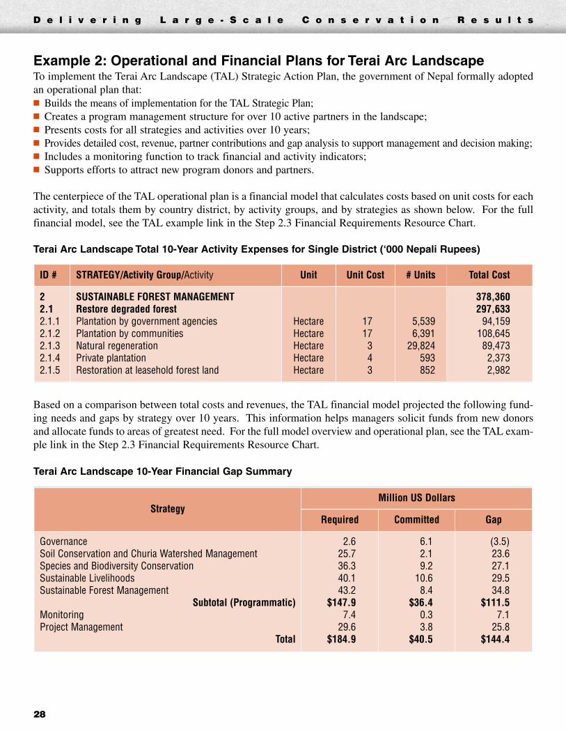
Application to Large ProgramsFor larger programs that have large and complex budgets, greater fund-rais-ing needs, and multiple partners and funding sources, a comprehensivefinancial model is the centerpiece of your operational plan.
The process of assigning costs to specific objectives and activities whilebuilding the model will help test and validate your action plan and activi-ties. The process of building the model can also help you evaluatescenarios of likely events.
The model’s data provide the basis for developing activity and financial per-formance indicators for tracking progress. For example, you can comparecosts estimated to undertake activities within the model with actual imple-mentation costs. You can also track activity progress by comparing plannedversus completed units over time.
Note that you can start developing your financial model once activities havebeen compiled in your action plan (Step 2.1). It may be easier to develop themodel along with your monitoring plan (Step 2.2), and while consideringyour program’s capacity requirements (Step 2.3 Capacity Requirements).You should also incorporate the cost of risk mitigation and exit strategy activ-ities from Steps 2.3 Risk Assessment and 2.3 Exit Strategy into your model.
➥ To access hyperlinks, pleasevisit www.panda.org/standards
Examples
• Mesoamerican ReefEcoregion
• Terai Arc Landscape
• Amazon Region ProtectedAreas
Guidelines & Tools
• Operational Plan (G)
• Single Protected AreaFinancial Model Template (T)
Outputs
• Estimates and analysis offinancial resources requiredto implement your project
Resource Chart
Step 2.3: Operational Plan
D e l i v e r i n g L a r g e - S c a l e C o n s e r v a t i o n R e s u l t s
27
INT
RO
DU
CT
ION
DE
FIN
ED
ES
IGN
IMP
LE
ME
NT
AN
ALY
ZE
& A
DA
PT
SH
AR
E
Tips:A financial model is not a budget.Models use extrapolated cost andrevenue estimates to forecastlong-term financial conditions andneeds that do not usually matchannual operating budgets oraccounting line items. Forguidance on short-term programbudgeting and links to WWFbudget templates, see Step 3.1.
Be realistic in predicting futurerevenue streams in your model.Avoid optimistic or uncertainestimates of grants or otherrevenue streams, especially fromuser fees, ecotourism, or otherconservation-supportingindustries that are untested inmany parts of the world.
D e l i v e r i n g L a r g e - S c a l e C o n s e r v a t i o n R e s u l t s
28
Example 2: Operational and Financial Plans for Terai Arc LandscapeTo implement the Terai Arc Landscape (TAL) Strategic Action Plan, the government of Nepal formally adoptedan operational plan that:� Builds the means of implementation for the TAL Strategic Plan;� Creates a program management structure for over 10 active partners in the landscape;� Presents costs for all strategies and activities over 10 years;� Provides detailed cost, revenue, partner contributions and gap analysis to support management and decision making;� Includes a monitoring function to track financial and activity indicators;� Supports efforts to attract new program donors and partners.
The centerpiece of the TAL operational plan is a financial model that calculates costs based on unit costs for eachactivity, and totals them by country district, by activity groups, and by strategies as shown below. For the fullfinancial model, see the TAL example link in the Step 2.3 Financial Requirements Resource Chart.
Terai Arc Landscape Total 10-Year Activity Expenses for Single District (‘000 Nepali Rupees)
Based on a comparison between total costs and revenues, the TAL financial model projected the following fund-ing needs and gaps by strategy over 10 years. This information helps managers solicit funds from new donorsand allocate funds to areas of greatest need. For the full model overview and operational plan, see the TAL exam-ple link in the Step 2.3 Financial Requirements Resource Chart.
Terai Arc Landscape 10-Year Financial Gap Summary
StrategyMillion US Dollars
Required Committed Gap
GovernanceSoil Conservation and Churia Watershed ManagementSpecies and Biodiversity ConservationSustainable LivelihoodsSustainable Forest Management
Subtotal (Programmatic)MonitoringProject Management
Total
2.625.736.340.143.2
$147.97.4
29.6$184.9
6.12.19.2
10.68.4
$36.40.33.8
$40.5
(3.5)23.6 27.129.534.8
$111.57.1
25.8$144.4
ID # STRATEGY/Activity Group/Activity Unit Unit Cost # Units Total Cost
22.12.1.12.1.22.1.32.1.42.1.5
SUSTAINABLE FOREST MANAGEMENTRestore degraded forestPlantation by government agenciesPlantation by communitiesNatural regenerationPrivate plantationRestoration at leasehold forest land
HectareHectareHectareHectareHectare
1717343
5,5396,391
29,824593852
378,360297,633
94,159108,64589,4732,3732,982

D e l i v e r i n g L a r g e - S c a l e C o n s e r v a t i o n R e s u l t s
29
Example 3: Financial Plan for Mesoamerican Reef EcoregionThe Mesoamerican Reef (MAR) Protected Area (PA) network developed a financial plan that included:� An assessment of capacity needs for creation and growth of 63 marine and coastal PAs; and� Completion of a 10-year comprehensive financial model for the PAs.
The next step of this process, now under way, entails development of a sustainable funding plan and campaign forthe PAs based on the financial model gap analysis.
Total Annual MAR Expenses, Revenue and Gaps by Year
The model represents four countries (Belize, Guatemala, Honduras and Mexico), and projects the costs of creating,consolidating and attaining full management of all 63 PAs over 10 years.
Gap Sensitivity by Country by Year
The MAR financial model presents costs and revenue for PAs in each country and a gap analysis for each PA and foreach country. It includes extensive sensitivity and gap analysis capability (physical contingency, price contingency,inflation, optimistic/expected/pessimistic scenarios).
INT
RO
DU
CT
ION
DE
FIN
ED
ES
IGN
IMP
LE
ME
NT
AN
ALY
ZE
& A
DA
PT
SH
AR
E
➥ To access hyperlinks, pleasevisit www.panda.org/standards
Examples
• Congo TRIDOM Landscape
• South Africa
Guidelines & Tools
• Operational Plan (G)
• Risk Ranking and MitigationTemplate (T)
Outputs
• An assessment of potentialrisks and specific mitigationstrategies
Resource Chart
Step 2.3: Operational Plan
Tip:For large programs, formallyrecognizing risks is not enough.Managers must set prioritiesamong them and actively pursuemitigation strategies for thosethat are most threatening.Experience has shown that thecosts of not pursuing mitigationstrategies can be substantial, andmay fully undermine a program.
D e l i v e r i n g L a r g e - S c a l e C o n s e r v a t i o n R e s u l t s
30
Risk Assessment and Mitigation StrategyA risk assessment is used to determine the various risks associated withyour program and to help your team develop mitigation strategies.Mitigation strategies should be integrated into implementation as early aspossible, allowing many risks to be anticipated and minimized prior to hav-ing a major impact on your program.
Your team can identify specific risks related to your program in a relativelyshort, informal meeting. The list of questions in the Risk Ranking andMitigation Template provides a starting point for your team’s discussion. Inthis process, the team should document all significant risks, including any thatmay not be covered by the list of questions.
The next step is to individually rank each risk identified during the assess-ment process. The team should rank each risk according to both itslikelihood (the likelihood of occurring over the life of the program) and itsseverity (the extent to which it would affect the program’s ability to achievegoals and objectives).
Once the assessment and ranking are complete, your team should identifya mitigation strategy for each serious risk. In addition to individual mitiga-tion strategies, your team should identify the parties responsible for bothtracking each risk and carrying out each mitigation strategy.
Application to Large ProgramsAlthough risk is common across any scale of conservation program, thenumber and relative impact of certain risks will increase with the size andcomplexity of a program. Larger programs often involve multiple coun-tries, which creates a unique set of potential problems associated withpolitical and economic support and stability.
For this reason, your team should assess, and plan to mitigate the political,economic and other risks that could impact achievement of your programvision. This could include developing strong, solid alliances with partnersin each country participating in your program.
The assessment process and development of mitigation strategies should beconducted as early as possible during your program design phase (Step 2). Theassessment, ranking and mitigation strategies should be reviewed and updatedregularly by the program manager, steering committee and workgroup.

Example 4: Risk Assessment, Prioritization, and Mitigation for CongoTRIDOM LandscapeThe extensive financial, partner and political risks the Congo TRIDOM Landscape program encounters are typicalof those faced by large conservation programs. The TRIDOM team used a matrix to assess, rank and develop mit-igation strategies for 11 key risks, 4 of which are displayed in the following table. For the full risk ranking andmitigation strategy grid, see the TRIDOM example link in the Step 2.3 Risk Assessment Resource Chart.
Sustainability, Project Lifespan, and Exit StrategyAn important component of the operational plan is your program’s sustainability. Sustainability refers to the abil-ity of a program to deliver ongoing benefits after the main part of external support has been completed.
To achieve sustainability, conservation programs initiated by international organizations may require a robust exitstrategy. An exit strategy encompasses activities that describe how you will phase out of a program or activityover the long term in a responsible way.
Going forward, an exit strategy should specify:� Estimated program life span and timing of major phases (Steps 1.2 and 2.1)� Strategies and activities that should and should not be continued (Steps 2.1 and 4.4)� Sources of sustainable financing required for program activities (Steps 2.3 and 3.2)� Organizations and individuals that will provide expertise, equipment and infrastructure to manage and imple-
ment activities (Steps 2.3 and 3.3)� Strategic partners or communities who will ensure long-term ownership of program activities and results
(Step 3.4)
Once you have detailed which organizations will continue to manage and implement program activities into thefuture, it is important to set expectations with all partners about what will happen during each program phase.
Risk RiskRanking Risk Mitigation Strategy
Logging companies notwilling to contributesignificantly to cost ofhunting surveillance intheir concessions
High • Work with logging industry federations toward adoption of clear standards forhunting management and ways to obtain their support.
• Fine logging companies for poaching that benefits from their logging roads orvehicles.
• Split operations cost of mobile antipoaching units among several loggingcompanies.
Insufficient support forlaw enforcement(against heavy poachingin particular)
Medium • Adopt and implement law enforcement strategy that does not hurt basiclegitimate interests of the majority of hunters and resource users.
• Involve administrative, military, political, and judiciary authorities.
Deteriorating politicaland economicconditions
Low • Continue basic conservation activities, even in times of conflict. Experience inthe Congo Basin (Democratic Republic of Congo, Congo Brazzaville) hasshown that this is feasible and can produce good results.
D e l i v e r i n g L a r g e - S c a l e C o n s e r v a t i o n R e s u l t s
31
INT
RO
DU
CT
ION
DE
FIN
ED
ES
IGN
IMP
LE
ME
NT
AN
ALY
ZE
& A
DA
PT
SH
AR
E
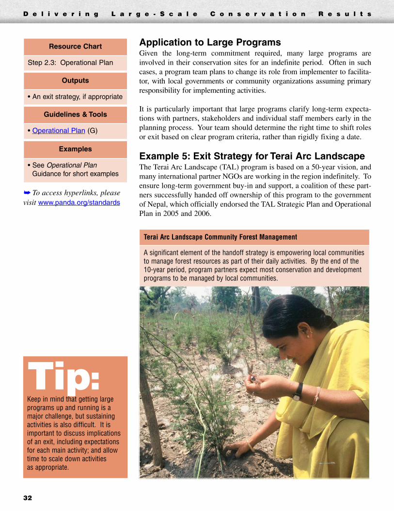
Tip:Keep in mind that getting largeprograms up and running is amajor challenge, but sustainingactivities is also difficult. It isimportant to discuss implicationsof an exit, including expectationsfor each main activity; and allowtime to scale down activities as appropriate.
D e l i v e r i n g L a r g e - S c a l e C o n s e r v a t i o n R e s u l t s
32
Application to Large ProgramsGiven the long-term commitment required, many large programs areinvolved in their conservation sites for an indefinite period. Often in suchcases, a program team plans to change its role from implementer to facilita-tor, with local governments or community organizations assuming primaryresponsibility for implementing activities.
It is particularly important that large programs clarify long-term expecta-tions with partners, stakeholders and individual staff members early in theplanning process. Your team should determine the right time to shift rolesor exit based on clear program criteria, rather than rigidly fixing a date.
Example 5: Exit Strategy for Terai Arc LandscapeThe Terai Arc Landscape (TAL) program is based on a 50-year vision, andmany international partner NGOs are working in the region indefinitely. Toensure long-term government buy-in and support, a coalition of these part-ners successfully handed off ownership of this program to the governmentof Nepal, which officially endorsed the TAL Strategic Plan and OperationalPlan in 2005 and 2006.
Terai Arc Landscape Community Forest Management
A significant element of the handoff strategy is empowering local communitiesto manage forest resources as part of their daily activities. By the end of the10-year period, program partners expect most conservation and developmentprograms to be managed by local communities.
➥ To access hyperlinks, pleasevisit www.panda.org/standards
Examples
• See Operational PlanGuidance for short examples
Guidelines & Tools
• Operational Plan (G)
Outputs
• An exit strategy, if appropriate
Resource Chart
Step 2.3: Operational Plan

STEP 3 Implement In the previous steps of the program cycle, your team developed action, monitoring and operational plans. In theImplement Step, you need to turn these general plans into action. This step involves:� Developing and executing specific workplans and budgets� Ensuring sufficient long-term fund-raising and sustainable financing for your program� Building the capacity necessary to deliver results� Instituting strong partner management to implement activities
As with previous steps, all of these elements are highly interlinked and most program teams go through them asan iterative process. You should change the order as your team sees fit, and revisit earlier elements at any time.
Step 3.1 Workplans and Budgets
OverviewIn this step, your team will begin turning your plans into reality through short-term workplans, budgets, fund-raising, and partner coordination and management.
Workplans and budgets are the building blocks of program implementation. Workplans derive from your action,monitoring, and operational plans, and specify the following:� Specific tasks required to complete each planned activity� Parties responsible for completing each task� Timing and deadlines for completing each task� Sequence of linked tasks that follow after each task is completed� Staff, partners, and other resources required to complete each task
There are many useful tools to develop and update your workplan. These include project management or spread-sheet software to record and track information in a table, Gantt charts, or program calendars.
Workplans are very detailed, and should reflect most if not all activities in your action plan. Teams generally pre-pare annual workplans, but the time frame can range from a few months to two or three years. The time frameis based on what is most useful for the short-term management of your program.
The detailed financial information compiled in Step 2.3 Financial Requirements provides a solid basis to preparea detailed budget for your program. Budgets typically span a year, but can be for any period that works best foryour program.
D e l i v e r i n g L a r g e - S c a l e C o n s e r v a t i o n R e s u l t s
33
INT
RO
DU
CT
ION
DE
FIN
ED
ES
IGN
IMP
LE
ME
NT
AN
ALY
ZE
& A
DA
PT
SH
AR
E

D e l i v e r i n g L a r g e - S c a l e C o n s e r v a t i o n R e s u l t s
34
The timelines for corresponding workplans and budgets should be thesame. This will help your team estimate and track costs to complete pro-gram activities.
Application to Large ProgramsLarge programs require significantly larger and more detailed workplans tomanage and track tasks—especially those programs that engage multiplepartners to carry out activities. Your team should track whether activitiesand tasks were completed, and within the expected time frame and budget.
Although large programs have considerably longer life spans than smallerones, you should still develop workplans and budgets for a one-, two-, or atmost three-year time frame. Activities more than three years out will becaptured by your action plan (Step 2.1).
Example 1: Workplan for Bering Sea EcoregionTo implement activities, the Bering Sea program team broke its objectivesinto actions and tasks. The following is an example of how these actionsand tasks could be represented in a Gantt chart workplan. Please note thatcertain details (such as dates) were added purely for illustration. For thefull illustrative spreadsheet, see the Bering Sea example link in the Step 3.1Resource Chart.
Bering Sea Workplan for Objective 3a
NOTE: This is a hypothetical workplan; only the actions and tasks are actuals.For the full list of actions and tasks, see the Bering Sea Strategic Plan.
Commercial Fisheries Objective 3a: Reduce the number of albatross and otherseabirds caught in longlines & nets by 90% by 2010 in US waters and by 50%by 2015 in Russian waters.
Tip:In working with multiple partners,each partner will likely have its ownbudget and workplan format. Youwill need a reliable means by whichgeneral progress on work andspending can be aggregated andreported to the team as a whole.
➥ To access hyperlinks, pleasevisit www.panda.org/standards
Examples
• Bering Sea Ecoregion(workplan)
• Congo TRIDOM Landscape(workplan)
Guidelines & Tools
• Workplans (G)
• Workplan Template (T)
• Budgeting (G)
• Budget Template (T)
Outputs
• Detailed workplan for yourproject showing tasks, whowill do them, and by when
• Project budget
Resource Chart
Step 3.1: Workplans andBudgets
Task # Task Complete Who Deadline Cost NOV DEC JAN 3a.1 Expand tori line
use in Russianlongline fleet
3a.1.1 Expand educationprogram withfishermen
✓K. Alvarez(WWF)
27.Nov.02 1,000
3a.1.2 Secure funding fortori lines andequipment;purchase and ship.
✓J. Miller(TNC)
15.Dec.02 2,000
3a.1.3 Tori lines distribu-tion between mainRussian longlinefishing companies
✓L. Ko(EPA)
10.Jan.03 2,000
3a.1.4 Other mitigatingequipment promo-tion (integratedweight line, etc.)
K. Alvarez(WWF)
01.Feb.03 3,000
KEY: � Milestones � Tasks � Phases

D e l i v e r i n g L a r g e - S c a l e C o n s e r v a t i o n R e s u l t s
35
Example 2: Workplan for Congo TRIDOM LandscapeThe five-year USAID Congo TRIDOM Landscape program uses one-year workplans to implement tasks groupedby activity categories. The following chart contains 7 of 284 tasks to be implemented in Cameroon, Congo andGabon in one fiscal year by the conservation NGO partners. This workplan provides detail on the amount (per-centage) of each task that will be complete every quarter, but does not list specific deadlines. For the fullworkplan, see the TRIDOM example link in the Step 3.1 Resource Chart.
Step 3.2 Fund-raising and Sustainable Financing
OverviewAll programs require funding, and those that span many years have critical needs for sustainable long-termfinancing. This step describes some of the means to raise funds for your program.
The many potential sources of program funding include:
� Direct government appropriations or public funds� User fees and payments for environmental prod-
ucts or services� Fines or penalties for illegal use of natural resources� Debt reduction and debt-for-nature swaps
� Grants or contracts from government aid agencies� Institutional, foundation, or private individual support� Funds raised through or generated by conservation
trust funds� Corporate support and partnerships
ActivityCategory Task
Responsibility % Task to be Completed in FY06
NGO Persons Q1 Q2 Q3 Q4
Data Collection/Assessment
Identify critical sites for maintaininglong-term connectivity betweenTRIDOM forest blocks
WWF De Wachter,Usongo,Madzou
25% 50% 75% 100%
Media/Outreach/Sensitization
Initiate environmental education andoutreach program with men, women,and youth in communities usingIvindo river below Makokou
WCS Chehoski 0% 100% 100% 100%
Implementation Design conservation headquarters inMakokou for Ivindo, Minkebe, andMwagne National Parks
WWF,WCS
De Wachter,Nigel
25% 50% 75% 100%
INT
RO
DU
CT
ION
DE
FIN
ED
ES
IGN
IMP
LE
ME
NT
AN
ALY
ZE
& A
DA
PT
SH
AR
E

D e l i v e r i n g L a r g e - S c a l e C o n s e r v a t i o n R e s u l t s
36
Traditional fund-raising involves soliciting donors such as aid agencies,foundations, corporations and individuals for grants that support some partof your program. These sources are excellent short- to medium-termsources of revenue, but in most cases cannot be counted on for continuedlong-term support over the life of your program.
Sustainable financing refers to recurring and reliable funding sources thatsupport your program over the long term, such as trust funds, debt swaps andpayments for services. All of these concepts require an investment in time(often more than a year) before you actually receive funding.
Your team can begin developing ideas or proposals, and begin meeting withkey donors or officials while you are still creating your action and operationalplans. After completing Steps 1 and 2, you will find that the logical and visu-al nature of the action, monitoring and operational plans help make a strongcase to government officials, prospective donors and other key partners.
Application to Large ProgramsLarge programs require significantly greater resources over longer periodsof time than do smaller conservation programs. Some of the largest andmost complex programs have costs into the hundreds of millions of dollarsover many years, or even decades.
Before considering specific funding sources and sustainable finance mecha-nisms, your team should agree on your program’s overall sustainable fundingplan. You should then develop funding mechanisms that best fit that strategy.
Long-term sustainable funding for large programs will almost certainlycome from a mix of sources that includes fees for services or other market-based solutions. Program managers often focus attention on more visiblesources such as foundations, but market sources and even governments areoften more reliable, long-term sources.
One of the most important means of supporting large programs is theengagement of partners. These might be donors, government agencies, orother NGOs who contribute financially or by executing part of the work.
Example 1: Partner Engagement in Terai ArcThe original Terai Arc Landscape (TAL) team was limited to a few partners.However, the team soon recognized that its 50-year vision for forest regen-eration, species distribution and sustainable livelihoods could not beachieved without significant funding and the engagement of many newpartner organizations.
Early in the planning effort, the team began to engage more and more part-ners. By the time TAL began full implementation, the team had attracted14 active partners, including aid agencies, the government and severalNGOs not traditionally involved in conservation (e.g. CARE). See Step 3.4for an example of the TAL governance structure used to manage the fullengagement of these 14 partners.
Tip:Given the long lead time requiredto prepare proposals and developsustainable financing vehicles,you may want to review linkedguidance in the Step 3.2 ResourceChart as you go through Steps 1and 2. However, full-blownproposals and fund-raising shouldwait until Steps 1 and 2 arecomplete, so program action,monitoring and operational plansare available to share with donorsand investors.
➥ To access hyperlinks, pleasevisit www.panda.org/standards
Examples
• Contact Development, GAA, & Sustainable FinanceStaff in WWF-I, WWF-US & WWF-UK
Guidelines & Tools
• Fund-raising (G)
• Sustainable Funding (G)
• WWF Internal ProposalForm (T)
Outputs
• Potential funding sourcesidentified and, if needed, asustainable funding plandeveloped
• Funding proposals submitted
Resource Chart
Step 3.2: Fund-raising andSustainable Financing

D e l i v e r i n g L a r g e - S c a l e C o n s e r v a t i o n R e s u l t s
37
Example 2: Sustainable Funding Campaign for Amazon Region Protected AreasThe Amazon Region Protected Areas (ARPA) program is a proposed network of 67 protected areas spanning theAmazon in Brazil. The sustainable funding campaign for this program, encompassing a land area larger thanCalifornia, was successfully launched after completing the following:� An assessment of capacity needs for creation, growth and achieving full management of all 67 protected
areas (Step 2.3 Capacity Requirements)� A comprehensive financial model (Step 2.3 Financial Requirements) representing the startup, consolidation
and long-term running costs of all 67 protected areas
The Brazilian Biodiversity Fund (FUNBIO), an independent conservation trust fund, receives and disbursesARPA funds and handles all procurement for the program. FUNBIO will also manage assets and disbursementsonce the endowment is established.
The following graph displays the number of Amazon region protected areas in each phase over 10 years, withtrust fund growth by year in the most optimistic scenario. For the full endowment projection, see the ARPAexample link in the Step 2.3 Financial Requirements Resource Chart.
After its first three years of implementation, the ARPA plan has achieved:� $86 million raised toward a $150 million, 10-year goal for establishing PAs� Approximately 16 million hectares of PAs established� Approximately 9 million hectares of new sustainable use areas� $14 million raised toward a long-term $240 million endowment goal
ARPA Phasing and Endowment Projections
ARPA Timetable
0
10
20
30
40
50
60
70
1 2 3 4 5 6 7 8 9 10 Years
PA
s
$0
$50,000
$100,000
$150,000
$200,000
$250,000
$300,000
Tru
st F
un
d (
,000
US
D)
New PA Created PAs in the Consolidation Component Total PAs in Full Operation Trust Fund
Phase I Phase II Phase III
INT
RO
DU
CT
ION
DE
FIN
ED
ES
IGN
IMP
LE
ME
NT
AN
ALY
ZE
& A
DA
PT
SH
AR
E

D e l i v e r i n g L a r g e - S c a l e C o n s e r v a t i o n R e s u l t s
38
Example 3: Conservation Debt Swap and Trust Fund for Madagascar Protected AreasIn January 2005, the Madagascar Foundation for Protected Areas and Biodiversity was formally established as apublic benefit foundation under Malagasy law. It was estimated that a $50 million trust fund was needed to sup-port conservation in Madagascar's protected areas. Conservation International and WWF have each contributed$1 million, and the government of Madagascar contributed 10.2 million euro through a debt-for-nature swap withthe government of Germany. In addition, the John D. and Catherine T. MacArthur Foundation provided $500,000for the fund, the World Bank committed $7.5 million in International Development Association (IDA) grants, andboth the French and German governments have expressed an interest in contributing.
Example 4: Fees for Services in Indonesia’s Bunaken National ParkIn 2002 the Bunaken National Marine Park collected $110,000 via an entrance fee system that charges foreignvisitors $17 per year or $5.50 per day, and Indonesian visitors 28 cents per visit. The entrance fee system wassuccessful because of user-friendly design, extensive marketing and effective enforcement. The park’s advisoryboard—which includes local villagers, tourism operators, local NGOs, the local university and various govern-ment agencies—manages the system. Eighty percent of fee revenues are reserved for park management, whereas20 percent are split among government agencies.
Step 3.3 Capacity Building
OverviewCapacity building is the process of developing your program’s ability toscale up to a larger level of activity and deliver results. To build capacity,your team should address the needs identified during your program’s capac-ity assessment (Step 2.3 Capacity Requirements).
Capacity building may include strengthening programmatic and technicalsupport (staff, consultants, training), managerial structures and support,financial and accounting systems, HR recruitment and retention, IT sys-tems, network and partner linkages, and development of financial or otherresources.
There are few tools that explicitly help you build capacity. However, onceyou carry out an assessment and begin raising funds and implementing yourprogram, there are many WWF Network and external sources of guidanceand assistance.➥ To access hyperlinks, please
visit www.panda.org/standards
Guidelines & Tools
• Program CapacityAssessment Template (T)
• Capacity Building (G)
Outputs
• Strategies developed andimplemented to addresscapacity shortfalls
Resource Chart
Step 3.3: Capacity Building

Application to Large ProgramsAs individual programs scale up, most do not have the leadership or staffskills to carry out work on the larger scale. This often leads to significantproblems delivering the necessary work and achieving desired results.
A major challenge during large program implementation is building capac-ity through your many partners. The capacity assessment done in Step 2.3Capacity Requirements should have included an examination of each part-ner’s capabilities and gaps with respect to your program.
Now your team needs to work with each partner to ensure that your pro-gram has the right skills and other resources to implement activities andachieve long-term sustainability. Your team should verify that the rightleadership, structure and resources are in place to efficiently and appropri-ately engage each partner.
Step 3.4 Partnerships
OverviewEach of your program partners is independent, with its own mission, pro-gram priorities and sources of funding. Unless partners’ participation isbound by contracts or grants, you should have a management system thatwill engage each partner over the lifetime of your program.
To build a strong partner management system you should:� Revisit your stakeholder analysis (Step 1.1) to make sure all key stake-
holders are engaged� Agree on accountability across all partners for completing all activities� Set up a process for monitoring progress of all partners� Budget for program management and monitoring support needs� Execute informal or formal arrangements (contracts, grants, MOUs,
PIAs, etc.) to carry out the work under your program with each partner� Include all these elements in an informal or formal partner coordination
or governance structure that will manage the work of the programgoing forward
Application to Large ProgramsFew large conservation programs achieve major, long-term results withoutthe active, long-term participation of partners. These partners are drawnfrom your stakeholder analysis (Step 1.1) and may be conservation NGOs,other NGOs, government agencies, aid agencies or other donors.
A typical partnership system that has worked successfully for large pro-grams has three parts:1. A program oversight team or steering committee. This is frequently
made up of some or all of your team, representing your closest andmost important partners.
➥ To access hyperlinks, pleasevisit www.panda.org/standards
Examples
• Terai Arc Landscape
• South Africa
• Amur-Heilong
• Mekong
Guidelines & Tools
• Partnerships and PartnerManagement (G)
Outputs
• New partners identified andbrought into program asappropriate
• Informal or formalarrangements with partnersdeveloped and implemented
• A system for workmanagement, decision-making, and accountability
Resource Chart
Step 3.4: Partnerships
D e l i v e r i n g L a r g e - S c a l e C o n s e r v a t i o n R e s u l t s
39
INT
RO
DU
CT
ION
DE
FIN
ED
ES
IGN
IMP
LE
ME
NT
AN
ALY
ZE
& A
DA
PT
SH
AR
E
Tip:Based on your capacityassessment, your team may needto conduct training, hireconsultants, or recruit and trainnew staff. Funding, staff, and thetime to do this should be builtinto your operational plan (Step2.3), workplans (Step 3.1),budgets (Step 3.1), and fundingproposals (Step 3.2).

D e l i v e r i n g L a r g e - S c a l e C o n s e r v a t i o n R e s u l t s
40
2. A program coordination or work team. This smaller unit is responsi-ble for coordinating the day-to-day work of the program and reportsup to the oversight team or steering committee. This role can beassigned to one of the partners on behalf of the overall program.
3. Internal or external program management and technical assistance(staff or consultants, or both). This function typically reports to theprogram coordination or work team.
It is also common to find that the oversight team is supplemented by anadvisory committee. The advisory committee might not have specificresponsibilities in terms of day-to-day work management or monitoring,but provides a logical place for your broader team or other key stakehold-ers to participate in an advisory capacity.
For large programs, the number and frequency of pivotal changes becauseof new funders, government policies and partners is significantly higher.Adopting an effective management system helps large programs ensure bet-ter long-term decision making and more seamless continuity of operations.
Terai Arc Landscape Governance System
STEERING COMMITTEE
Purpose: Provides strategic direction for TAL, develops high-levelpolicy, approves budgets, coordinates stakeholders, andcommunicates the landscape vision to involve prospective donorsand partners
ADVISORY COMMITTEE
Purpose: Provides technicaladvice for implementation ofactivities and offers a venue for awider group of stakeholders tohave a voice in the TAL program
SUPPORT UNIT
Purpose: Functions as a secretariat to the Steering Committee.Headed by a full-time staff TAL Coordinator, this body will overseeprogram-level work and will collect and collate landscape levelinformation to monitor progress.
PROJECTS
(Implemented by partners & grant-funded)
Tip:Whether your system has onelevel or many, the need for clearaccountability is crucial—especially when many partnersare involved. Limit the oversightentity to a few partners who arecentral to the program’s success;push partners toward a long-termcommitment of full-time participationin the system; and use thecoordination office as the single pointof control to manage work flow andmonitor progress.
Example 1: Partner Governance Structure for Terai Arc LandscapeAs Nepal’s largest government-led conservation undertaking, the Terai Arc Landscape (TAL) program requires amanagement system that ensures full and effective implementation and monitoring of more than 10 partners’activities over 10 years. The system created by the TAL team (and adopted by the government) is flexible andadaptive, and will ensure better landscape-wide linkage among programs in the region.

D e l i v e r i n g L a r g e - S c a l e C o n s e r v a t i o n R e s u l t s
41
STEP 4 Analyze and AdaptOverviewRegardless of how well a program is planned and managed, your team should fund and carry out a consistenteffort to monitor performance and results.
In Step 2 (Design), your team produced an action plan, an operational plan, and a monitoring plan. These plansprovide you with a set of financial, activity-based and programmatic indicators against which to track your pro-gram’s progress as well as specific status indicators for each biodiversity target.
You should have also built the costs of both progress and results monitoring into your financial model (Step 2.3Financial Requirements), and into your short-term workplans and budgets (Step 3.1). Assuming you have theresources to carry out monitoring, you are now set to move through this step.
This step breaks down into four areas of activity that your team will carry out over the life of your program:� 4.1 Manage incoming data on an ongoing basis� 4.2 Analyze program results and assumptions� 4.3 Analyze program performance� 4.4 Adapt your plans and budgets
Remember—you should monitor only the data necessary to report status and make good management decisionsover the life of your program. This will save costs and prevent your team from becoming bogged down by super-fluous data sets.
Resource Chart—Step 4: Analyze and Adapt
➥ To access hyperlinks, please visit www.panda.org/standards
Step Outputs Guidelines & Tools Examples
4.1: Manage IncomingData on an OngoingBasis
• Development andregular use of systemsfor collecting andstoring data
• Manage IncomingData (G)
• Contact Science,Finance andAdministration, andOperationsDepartments in WWF-I, WWF-US and WWF-UK
4.2: Analyze ProgramResults andAssumptions
• Regularly scheduledanalysis of projectresults and assumptions
• Documentation ofanalysis and decisions
• Regular reports toproject team membersand key stakeholders
• Analyze ProjectResults andAssumptions (G)
• Technical ProjectReport Template (T)
• Contact Science,Finance andAdministration, andOperationsDepartments in WWF-I, WWF-US and WWF-UK
INT
RO
DU
CT
ION
DE
FIN
ED
ES
IGN
IMP
LE
ME
NT
AN
ALY
ZE
& A
DA
PT
SH
AR
E

D e l i v e r i n g L a r g e - S c a l e C o n s e r v a t i o n R e s u l t s
42
➥ To access hyperlinks, please visit www.panda.org/standards
Application to Large ProgramsThe Analyze and Adapt Step is particularly important for large programs, which can be subject to any number ofexternal forces or change that affect your intended results (e.g. new threats, economic dislocation, changes ofgovernment, or other unforeseen risks).
Your program results will benefit from consistent monitoring and reporting. The agility with which your program canadapt to unexpected results or to changes in circumstances depends directly on how thoroughly you follow this step.
Step 4.1 Manage Incoming Data on an Ongoing Basis
It is important to systematically check, clean and code raw data as soon asyou get it. As you develop your monitoring and operational plans (Steps2.2 and 2.3), be sure to consider how you will store and back up your data.
Try to analyze and discuss your data regularly as you collect it, to verifythat the program is on track. At various times, your team will be evaluat-ing both programmatic and operational data, including progress metrics,key performance indicators (KPIs), results indicators and data on changesto core assumptions.
Step Outputs Guidelines & Tools Examples
4.3: Analyze Operationaland FinancialFunctions/Performance
• Appropriate scheduledanalysis of operationaland financial data
• Regular financial reports(including financialforecasts)
• AnalyzeOperational andFinancialFunctions/Performance (G)
• R3 FinancialReport (T)
• Contact Science, Financeand Administration, andOperations Departmentsin WWF-I, WWF-US andWWF-UK
4.4: Adapt Your Plansand Budgets
• Revised workplans andbudgets
• Adapt Your Plansand Budgets (G)
• Contact Science, Financeand Administration, andOperations Departmentsin WWF-I, WWF-US andWWF-UK
Tip:Make realistic estimates of the timenecessary to analyze program dataand results. This will prevent acommon problem: collecting a lotof data that you do not have enoughtime to analyze and assimilate.
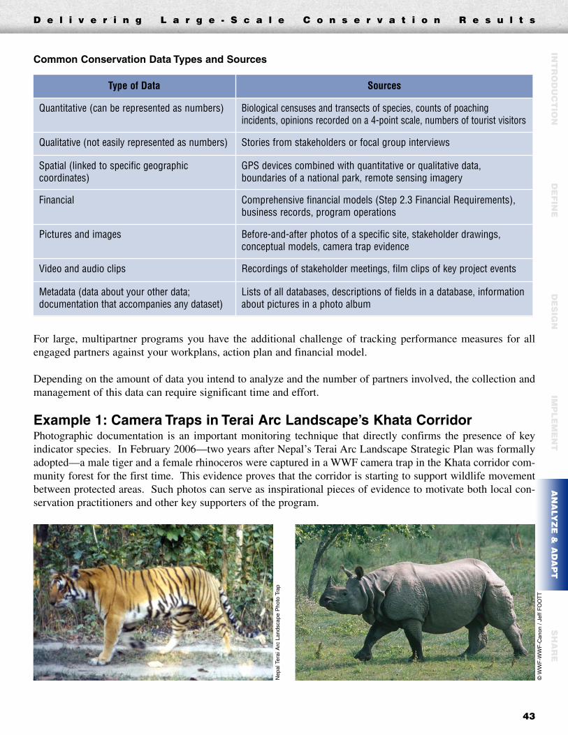
D e l i v e r i n g L a r g e - S c a l e C o n s e r v a t i o n R e s u l t s
43
Common Conservation Data Types and Sources
For large, multipartner programs you have the additional challenge of tracking performance measures for allengaged partners against your workplans, action plan and financial model.
Depending on the amount of data you intend to analyze and the number of partners involved, the collection andmanagement of this data can require significant time and effort.
Example 1: Camera Traps in Terai Arc Landscape’s Khata CorridorPhotographic documentation is an important monitoring technique that directly confirms the presence of keyindicator species. In February 2006—two years after Nepal’s Terai Arc Landscape Strategic Plan was formallyadopted—a male tiger and a female rhinoceros were captured in a WWF camera trap in the Khata corridor com-munity forest for the first time. This evidence proves that the corridor is starting to support wildlife movementbetween protected areas. Such photos can serve as inspirational pieces of evidence to motivate both local con-servation practitioners and other key supporters of the program.
Type of Data Sources
Quantitative (can be represented as numbers) Biological censuses and transects of species, counts of poachingincidents, opinions recorded on a 4-point scale, numbers of tourist visitors
Qualitative (not easily represented as numbers) Stories from stakeholders or focal group interviews
Spatial (linked to specific geographiccoordinates)
GPS devices combined with quantitative or qualitative data,boundaries of a national park, remote sensing imagery
Financial Comprehensive financial models (Step 2.3 Financial Requirements),business records, program operations
Pictures and images Before-and-after photos of a specific site, stakeholder drawings,conceptual models, camera trap evidence
Video and audio clips Recordings of stakeholder meetings, film clips of key project events
Metadata (data about your other data;documentation that accompanies any dataset)
Lists of all databases, descriptions of fields in a database, informationabout pictures in a photo album
INT
RO
DU
CT
ION
DE
FIN
ED
ES
IGN
IMP
LE
ME
NT
AN
ALY
ZE
& A
DA
PT
SH
AR
E
Nep
al T
erai
Arc
Lan
dsca
pe P
hoto
Tra
p
©W
WF
-WW
F-C
anon
/ J
eff
FO
OT
T

D e l i v e r i n g L a r g e - S c a l e C o n s e r v a t i o n R e s u l t s
44
Step 4.2 Analyze Program Results and Assumptions
One of the most important aspects of the monitoring and analysis process is that it allows you to systematicallyassess whether you are on track to achieve your stated goals, objectives and long-term results.
The analysis in this step largely focuses on the status and results indicators derived from the conceptual model,results chains, or logframes developed in Steps 1.4 and 2.1. The monitoring plan (Step 2.2) provides the blue-print for this analysis.
The types of analysis you employ may range from formal statistical studies to simple qualitative assessments.Input from experts outside core program team organizations may be especially useful for complex quantitative analysis.
Example 1: Biological Indicators Analysis in Terai Arc LandscapeAt various intervals, the Terai Arc Landscape (TAL) program team tracks the status of species and habitat targets(Step 1.3) using biological indicators against 10-year goals. Following is an abbreviated example of the type ofbiological target analysis that the team performs regularly.
Target Indicator Baseline(2004)
Activities to Assessor Improve
3-Year ActionPlan
Milestones
10-YearStrategic
Plan Goals
% TowardSuccess at
3-yearMilestone
Tigers
# of adult tigers inTerai Arc Landscape
Nepal~200
Conduct tiger (or proxy prey)
surveys and enter indatabases on status
and distributions
>300 >400 38%
# of adult tigers inTerai Arc Landscape
India<100 >100 >200 36%
# of adult tigers inTerai Arc Landscape
India/Bhutan<100 >100 >200 25%

D e l i v e r i n g L a r g e - S c a l e C o n s e r v a t i o n R e s u l t s
45
Step 4.3 Analyze Operational and Financial Functions/Performance
Your program’s action plan (Step 2.1) and financial model (Step 2.3 Financial Requirements) provide a goodbasis on which to develop activity-based and financial performance indicators your team can track regularly. Itis important that your team regularly analyze these indicators to determine whether activities are being carriedout, and whether financial resources are adequate to sustain these activities.
Example 1: Activity-Based Analysis in Terai Arc Landscape
Step 4.4 Adapt Your Plans and BudgetsAlthough the planning your team carried out in Steps 1 and 2 was thorough, it may be necessary to revisit yourassumptions or even targets, threats, goals, objectives and activities if monitoring results indicate a significantchange in your program.
As your team makes changes, carefully document the rationale behind each change so your program partners andstakeholders understand why modifications were made. Communicating both progress and changes to your team,partners, donors and other stakeholders is a critical part of program analysis.
The Terai Arc Landscape (TAL) programteam tracks units of each activity completedby each partner in each district during eachyear of its 10-year program. The values inthis example are hypothetical, and do notreflect actual TAL program progress.
Banke District
Unit
IntendedUnits to
Completein Year 1
UnitsCompletedin Year 1
Gap
IntendedUnits to
Completeby Year 10
% of Year 10Program GoalCompleted to
Date
2.Sustainable Forest Management2.1 Restore Degraded Forest 43,199 41,000 2,199 390,000 11%
2.1.1 Plantation by government agencies Hectare 5,539 3,000 2,539 50,000 6%2.1.2 Plantation by Communities Hectare 6,391 7,000 (609) 75,000 9%2.1.3 Natural Regeneration Hectare 29,824 30,000 (176) 250,000 12%2.1.4 Private Plantation Hectare 593 400 193 10,000 4%2.1.5 Restoration at Leasehold forest land Hectare 852 600 252 5,000 12%
INT
RO
DU
CT
ION
DE
FIN
ED
ES
IGN
IMP
LE
ME
NT
AN
ALY
ZE
& A
DA
PT
SH
AR
E

D e l i v e r i n g L a r g e - S c a l e C o n s e r v a t i o n R e s u l t s
46
STEP 5 ShareOverviewThe final step in the program management cycle is devising a systematic means to share lessons, best practices,outputs and results with your team, and with key internal and external audiences.
Although the concept of capturing and sharing learning seems simple, it is often the last thing practitioners thinkabout in planning and managing programs. As a result, valuable lessons are lost.
It is critical to capture lessons so that program staff and managers can learn from previous experiences and savevaluable time. World Wildlife Fund staff can use Connect or one of the organization’s other knowledge or datamanagement systems. All readers can use a broader conservation sharing network, such as ConserveOnline(www.conserveonline.org).
The Share Step includes giving and receiving feedback, conducting evaluations and audits, and educating part-ner organizations and other stakeholders. This step has four basic areas of activity your team should consider:� 5.1 Lessons, results and best practices� 5.2 Formal communication products� 5.3 Feedback and evaluations� 5.4 Learning systems and culture
➥ To access hyperlinks, please visit www.panda.org/standards
Step Outputs Guidelines & Tools Examples
5.1: Lessons and BestPractices
• Documented lessons and best practices
• Sharing Lessons(G)
• See SharingLessons Guidancefor short examples
5.2: FormalCommunicationStrategy andProducts
• Identification of key audiences
• Development ofcommunications strategy
• Development and distributionof communications products
• CommunicationsStrategy (G)
• SeeCommunicationsStrategy Guidancefor short examples
5.3: Feedback,Evaluations andAudits
• Feedback
• Evaluations and/or audits
• Feedback,Evaluations andAudits (G)
• Evaluations Termsof Reference (T)
• Audit Tool (T)
• Colombia SocialChange Evaluation
• Minshan PandaProgram Evaluation
5.4: Performance andLearning Culture
• Demonstrated commitmentfrom leaders to learning andinnovation
• Performance andLearning Culture(G)
• See Performanceand Learning CultureGuidance for shortexamples
D e l i v e r i n g L a r g e - S c a l e C o n s e r v a t i o n R e s u l t s
47
INT
RO
DU
CT
ION
DE
FIN
ED
ES
IGN
IMP
LE
ME
NT
AN
ALY
ZE
& A
DA
PT
SH
AR
E
Step 5.1 Lessons and Good Practice
Your team should discuss the best means by which it can keep track of the lessons learned, work results (bothsuccesses and failures), and best practices related to different steps of the program management process.
At the very least, one organization should do this for the team, and set up one folder or repository for final ver-sions of each product and output from the process—including documentation of program progress and results.
Step 5.2 Formal Communication Strategy and ProductsYour team should also have a formal or informal strategy to communicate results of your work to current andfuture donors and stakeholders.
There are various guidelines and tools on communication strategies and techniques offered by the communica-tions departments in WWF-I, WWF-US, or other WWF offices. You should take advantage of these services incommunicating your program’s progress to your donors, other stakeholders and the media.
In large programs with long time horizons, it is critical to document the steps you took and progress you madefor the benefit of future participants. This is especially important if you change your assumptions, goals, objec-tives, action plan, or operational plan.
Step 5.3 Feedback, Evaluations, and AuditsEvaluations and audits are two formal mechanisms to receive feedback about program findings, processes andlessons learned. Evaluations assess programs against their own stated goals and objectives. Audits assess pro-grams against a formal set of standards such as the set used in this guide. Your team might consider carrying outa more formal evaluation or audit at some point in your program’s life cycle. This would augment your regular mon-itoring data and allow you to take a snapshot of overall program status.
Step 5.4 Performance and Learning CultureWorld Wildlife Fund has developed various systems for capturing learning, such as WWF Connect or the WWF-US knowledge management repository (on the WWF-US intranet). As WWF rolls out usage of the Standards inlarge programs, your team should use these systems (or others as appropriate) to share both successes and fail-ures with other practitioners around the world.
Please email outstanding guidance documents, tools and examples pertaining to any step of the Standards processto [email protected], so they can be shared with the broader conservation community. Alternatively, visitwww.conserveonline.org for the largest compilation of conservation management best practices on the Internet.

D e l i v e r i n g L a r g e - S c a l e C o n s e r v a t i o n R e s u l t s
48
AppendixWWF Standards of Conservation Project and Program Management
The WWF Standards are a set of best practices tohelp practitioners deliver conservation results.Developed in conjunction with major inter-national environmental NGOs andendorsed by the WWF Network, theStandards lend consistency to plan-ning, implementing and monitoringeffective conservation projects andprograms worldwide.
StepsVisit www.panda.org/standardsto access guidance, tools andexamples for each step. Pleaseemail outstanding guidance docu-ments, tools and examples [email protected].
1 Define1.1 Team Composition and Operations1.2 Scope and Vision1.3 Targets1.4 Context and Threats
2 Design2.1 Action Plan: Strategies, Goals,
Objectives and Activities2.2 Monitoring Plan2.3 Operational Plan
3 Implement3.1 Workplans and Budgets3.2 Fund-raising and Sustainable Financing3.3 Capacity Building3.4 Partnerships
4 Analyze and Adapt4.1 Manage Incoming Data on an Ongoing Basis4.2 Analyze Program Results and Assumptions4.3 Analyze Operational and Financial
Functions/Performance4.4 Adapt Your Plans and Budgets
5 Share5.1 Lessons and Best Practices5.2 Formal Communication Strategy and Products5.3 Feedback, Evaluations, and Audits5.4 Performance and Learning Culture

D e l i v e r i n g L a r g e - S c a l e C o n s e r v a t i o n R e s u l t s
Photo CreditsCOVER:© WWF-Canon / Chris HAILS© WWF-Canon / WWF-Pakistan/Uzma Khan© WWF-Canon / Michel GUNTHER© WWF-Canon / StÉfane MAURIS
PAGE 5:© WWF-Canon / Michel GUNTHER© WWF-Canon / Michel GUNTHER© WWF-Canon / Frederick J. WEYERHAEUSER© WWF-Canon / Edward PARKER
PAGE 8:© WWF-Canon / Michel GUNTHER© WWF-Canon / Robert DE JONGH© WWF-Canon / Anthony B. RATH© WWF-Canon / Sylvia EARLE
PAGE 11:© WWF-Canon / Kevin SCHAFER© WWF-Canon / Kevin SCHAFER© WWF-Canon / Kevin SCHAFER© WWF-Canon / Michel GUNTHER
PAGE 13:© WWF-Canon / Jeff FOOTT© WWF-Canon / Edward PARKER© WWF-Canon / Edward PARKER© WWF-Canon / Kevin SCHAFER
PAGE 18:© WWF-Canon / Gustavo YBARRA© WWF-Canon / Gerald S. CUBITT© WWF-Canon / Jeff FOOTT© WWF-Canon / Matt WILKINSON
PAGE 22:© WWF-Canon / Gustavo YBARRA© WWF-Canon / Gustavo YBARRA© WWF-Canon / Gustavo YBARRA© WWF-Canon / Carlos DREWS
PAGE 25:© WWF-Canon / Kevin SCHAFER© WWF-Canon / Kevin SCHAFER© WWF-Canon / Martin HARVEY© WWF-Canon / Martin HARVEY
PAGE 32:© WWF-Canon / Helena TELKÄNRANTA
PAGE 33:© WWF-Canon / Kevin SCHAFER© WWF-Canon / Kevin SCHAFER© WWF-Canon / Martin HARVEY© WWF-Canon / Frederick J. WEYERHAEUSER
PAGE 35:© WWF-Canon / Jeff FOOTT© WWF-Canon / Zig KOCH© WWF-Canon / Zig KOCH© WWF-Canon / Zig KOCH
PAGE 38:© WWF-Canon / Michel GUNTHER© WWF-Canon / Diego M. GARCES© WWF-Canon / Michel GUNTHER© WWF-Canon / Diego M. GARCES
PAGE 42:© WWF-Canon / Jeff FOOTT© WWF-Canon / Jeff FOOTT© WWF-Canon / Jeff FOOTT© WWF-Canon / Jeff FOOTT
PAGE 44:© WWF-Canon / Jeff FOOTT© WWF-Canon / Michel GUNTHER© WWF-Canon / Helena TELKÄNRANTA© WWF-Canon / Helena TELKÄNRANTA
PAGE 45:© WWF-Canon / Helena TELKÄNRANTA© WWF-Canon / Helena TELKÄNRANTA© WWF-Canon / Helena TELKÄNRANTA© WWF-Canon / Matt WILKINSON
PAGE 47:© WWF-Canon / Zig KOCH© WWF-Canon / Zig KOCH© WWF-Canon / Martin HARVEY© WWF-Canon / Martin HARVEY

D e l i v e r i n g L a r g e - S c a l e C o n s e r v a t i o n R e s u l t s
World Wildlife Fund1250 24th Street, NWWashington, DC 20037-1193USAPhone: 202-293-4800Fax: 202-293-9211Email: [email protected]
This guide is printed on FSC certified paper using 100% post consumer waste.Use of this paper saves 10 mature trees; reduces solid waste by 638 lbs.; and reduceswater usage by 6,016 gallons.
World Wildlife Fund is the largest conservation organization in the world. For 45 years,WWF has worked to save endangered species, protect endangered habitats, and addressglobal threats such as deforestation, overfishing, and climate change. Known worldwideby its panda logo, WWF works in 100 countries on more than 2,000 conservationprograms. WWF has 1.2 million members in the United States and nearly 5 millionsupporters worldwide.
This document contains materials adapted from other sources. Ownership of thesematerials is retained by the copyright holder.
Cert no. SCS-COC-00518