Delivering expert system design and COTS … expert system design and COTS equipment solutions for...
24
Delivering expert system design and COTS equipment solutions for over two decades www.NavtechGPS.com • 800.628.0885 • +1.703.256.8900 • Woman-Owned Small Business GPS/GNSS Equipment Overview YOUR ONE SOURCE FOR GNSS EQUIPMENT AND TRAINING launch • RecoveRy • geopositioning • navigation v041516
Transcript of Delivering expert system design and COTS … expert system design and COTS equipment solutions for...

Delivering expert system design and COTS equipment solutions for over two decades
www.NavtechGPS.com • 800.628.0885 • +1.703.256.8900 • Woman-Owned Small Business
GPS/GNSS Equipment Overview
Your one source for Gnss equipment and traininG
launch • RecoveRy • geopositioning • navigation
v041
516

NavtechGPS
ACCORD
We sell products from ...
... and many more!
®
V041516
®
Your ONE Source for GNSS Products, Solutions and Training
Woman-owned small Business 8(m)
GNSS Training and SeminarsNavtechGPS is a world leader in GPS/GNSS education and training with nearly 30 years of experience. We conduct on-site courses for 10 or more people, saving you
overhead, travel expenses and time. We can tailor any course from our comprehensive list of courses to
meet your group’s needs. For individuals or smaller groups, our public venues offer an excel-
lent learning environment, networking opportunities and time for in-depth instruction.
Contact UsThe choices you want. The expertise you need.
Monday – Friday: 0900 – 1730, EST+1-703-256-8900 or 1-800-NAV-0885www.NavtechGPS.com [email protected]
References and BooksWe stock highly specialized GPS/GNSS titles. Most orders ship the same day. order online, by phone or fax.
Products and ServicesIn-house expertise on a wide range of components and systems from more than 30 manufacturers.
all trademarks, service marks, and trade names are the property of their respective owners and navtechgps makes no claim with respect to them. all other product names and services are used in editorial fashion for the benefit of such companies with no intention of infringement of the mark.
customized systems using off-the-shelf components (cots) indoor locating and positioning in gps-denied areas RF networking system design and installation (Das) space weather monitor receivers for tracking through scintillation. hand-held gnss jamming, interference detection and mitigation Differential subscription services gnss heading and attitude oeM receiver boards Gps/Gnss simulators oeM on-chip gps-aided ins gnss development software signal distribution products gnss inertial navigation gnss signal interference mitigation post-processing software
gnss record/replay ppp systems RtK systems Gnss antennas smart antennas customized cables gis equipment sBas

navtechgps® represents industry leading manufacturers of gnss products, components and auxiliary products. contact us: 1-703-256-8900 or 800-628-0885 or [email protected]
Acumen. portable, set-it-forget-it black box data loggers.
AntCom. antenna division of novatel. Quality, moderately priced
single- and multi-frequency antennas for geodetic, gis, automotive, airborne and marine applications.
Ashtech. single and dual frequency gps/gnss oeMs/sensors/receivers for precision positioning, guidance, navigation and timing. specifically for use in high-performance applications.
Beyondoor. small, cost effective l1 antennas.
Chronos Technology. handheld gps jamming detectors and locators.
Fugawi. Real-time, editable, moving map software.
Freewave. spread spectrum radio modems, oeM and boxed.
Forsberg Services Ltd . Forsberg starlink Dgps
products: in-line signal amplifiers, Ducs, fiber optic link system, splitters. (navtechgps is the sole distributor for Forsberg starlink gps products in the u.s. and canada)
GPS Networking. signal splitters, amplifiers and signal distribution, re-radiation systems.
GPSoft. satnav, ins, Kalman filtering MatlaB® toolboxes.
Hemisphere GNSS. single and dual frequency oeM and boxed receivers. gps compass products with integrated gyroscope. Many form factors.
NavtechGPS
a Woman-owned small Business 8(m)
Your one source for Gnss products and solutions
LabSat by Racelogic. multi-constellation Gnss simulator (Gps/
glonass/galileo, BeiDou, QZss or sBas). Record - playback multiple base band satellite RF signals.
L3NAV. gps, Kalman Filtering, RineX and spc (Ras), and coordinate transformations (ct) software for matLaB® toolboxes.
NavCom. single and dual frequency rugged receivers. several form factors, some with internal radios. complete survey (including aerial survey) and high accuracy posi-tioning systems. producers of starfire, a satellite based differential correction service.
NovAtel. single and dual frequency gps receivers. glonass and galileo capability. oeM receiver boards and
boxed receivers with varying form factors. Multi-band antennas. Firmware options to support high data rates, carrier phase outputs and Dgps.
navXperience. Robust, light, accurate, next generation, 4
constellation antennas. ngs calibrated.
Omnistar. subscription options include localized or worldwide, short- or long-term and varying accuracy levels.
OxTS. inertial navigation systems, combining gnss technology with high-perfor-mance inertial sensors. available with dual antenna and dual frequency configurations for gnss heading/roll or heading/pitch. also includes post-processing software!
®
Pacific Crest. uhF radio transceiv-ers and accessories.
Panasonic. high gain antennas for timing and other facilities applications.
PCTEL. Diverse line of primarily single frequency antennas. timing and reference, automotive and marine applications. also smart antennas and receiver modules. Many form factors.
Raven Industries. navtechgps is the sole u.s. distributor of Raven gps
antenna products.
SECO Manufacturing. survey accessories, custom mounts, packs, tripods & more. Mobile gps mountings.
Septentrio. high sensitivity single and multi-frequency receivers. gps/galileo/glonass. heading units. high output rates. oeM receiver boards and boxed receivers, plus septentrio's advanced interference Mitigation (aiM+) technology. gps/galileo receivers for signal analysis.
SpectraPrecision. Rugged, handheld mobile mapping
devices for field data collection for gis, mobile mapping and survey.
Tallysman. small form factor Gnss antennas and amplifiers, and sMaRt antennas. single frequency l-band and gnss inline signal amplifiers, splitters,
bias-tees and lightning arresters.
Trimble. high quality, high accuracy oeMs providing seamless integration, whatever the application, for high-precision positioning solutions.
VectorNav. oeM gps-aided ins, inertial measurement unit and
attitude heading Reference system (iMu/ahRs).
Waypoint, a novatel company. Waypoint grafnav/grafnet post-processing software.
NavtechGPS 5501 Backlick Road suite 230 springfield, va 22151
V041
516
www.navtechgps.com [email protected] +1-703-256-8900
Since 1984

Product details at www.NavtechGPS.com. For more information: 1-800-628-0885; +1-703-256-8900; or [email protected].
Distributors Resellers Integrators Innovators
4
CTL-3500 GPS L1 Interference Monitorthe ctl-3500 gps l1 interference Monitor is a low-cost, battery-operated handheld gps jam-ming detector that detects the presence of too much gps satellite power or non-gps signal and interference broadcasting on the satellite navigation l1 channel, which could indicate inadver-tent interference or intentional electronic warfare attacks intended to jam gps signals.
CTL-3510 GPS Jammer Detectorthe chronos ctl-3510 gps Jammer Detector is a low-cost, handheld, battery operated device designed to detect the presence of gps jamming or too much power or interference in the gps (l1) band.
CTL-3510-LOG GPS Jammer Detector and Loggerthe ctl-3510 got even better. it builds on the basic features of the ctl-3500 but with a more sensitive handheld device that now has an internal event logging option. like the original ctl-3510, the ctl-3510 with event logging is also battery operated and designed to detect the pres-ence of gps jamming or too much power or interference in the gps (l1) band.
CTL-3520 Handheld Directional GPS Jammer Detector and Locatorthe chronos ctl-3520 directional gps jammer detector and locator is a handheld, battery oper-ated device designed to detect and quickly locate the presence of jamming signals from commer-cially available gps jammers or too much power or interference broadcast in the gps (l1) band.
the ctl-3520 uses innovative direction finding technology developed by the university of Bath to accurately determine which vehicle or individual is hosting the jammer, and then point the user in the direction of the jammer.
aimed specifically at detecting gps jammers hidden in vehicles, the unit can pinpoint even the weakest jammer and identify the vehicle in which the jammer is hidden, even in a busy multi-level parking garage. other applications include detecting vehicles with jammers at air-ports, fleet depots, airport parking garages and in taxi fleets.
Chronos Technology
chronos technology has developed low-cost, battery-operated handheld gps jamming detectors and locators that detect the presence of too much gps satellite power or non-gps signal and interference broadcasting on the satellite navigation l1 channel. these detectors could be used by the Fcc, the Faa, law enforcement, trucking companies, vehicle fleets, in test labs, for field use, in airports, in toll booths, by local and federal governments, and in many other business uses.
NavtechGPS has partnered with Chronos Technology to market these products in the United States. Contact us about how these products can help alert you to GPS jamming and unintended GPS signal interference.

Product details at www.NavtechGPS.com. For more information: 1-800-628-0885; +1-703-256-8900; or [email protected].
Distributors Resellers Integrators Innovators
5
navtechgps is pleased to partner with Forsberg to handle the north america sales and distribution of the now Forsberg starlink RF line of gnss / gps down-up converters, signal splitters and in-line amplifiers, as well as the Forsberg Raven link system of transmitters and receivers.
the Forsberg starlink (formerly Raven starlink Dpgs) gps signal splitters and fiber-optic solutions resolve the difficulties associated with signal losses due to extended antenna cable lines of practically any length.
Forsberg services, ltd., acquired Raven's starlink gnss product line from Raven industries in april 2015. NavtechGPS is the exclusive North American distributor for the Forsberg StarLink product line.
GNSS Solutions for Extended Cabel Runs
Inline AmplifiersForsberg starlink in-line amplifiers are a convenient way to boost and filter gps signals before they reach the receiver.
Down/Up Convertersthe patented gps Down/up converter makes it possible for long cable runs of 450 meters. the Duc converters are the perfect add-on for l1 gps installations where long antenna cables are needed and a simple in-line ampli-fier will not suffice. a Duc consists of a down converter at the gps antenna and an up converter at the RF input of the gps receiver.
Fibre Optic Link Systemthe Rvl-1 Fiber optic link system is an affordable gps fiber optic antenna link system for gps and gnss systems, which offers excep-tional lightning protection.
Splittersthe Forsberg starlink split-ters are designed to provide two Dgps receivers with a signal from a single antenna by dividing the outgoing signal into two separate gps receivers with minimal signal loss.

Product details at www.NavtechGPS.com. For more information: 1-800-628-0885; +1-703-256-8900; or [email protected].
Distributors Resellers Integrators Innovators
6
Introducing AtlasTM Global Correction Service
You wanted more from Hemisphere and they listened! hemisphere gnss has long been known for their l1 gps receivers and uscg beacon receivers. in recent years, they have come on strong in the l1/l2 gps marketplace. With the introduction of the eclipse oeM boards several years ago, hemisphere gnss has established its presence in the dual frequency market. not only is the eclipse ii oeM board available in the R330 extruded sensor box, but it is now available in a new line of all-in-one, on-the-pole receiver systems. add to this their coast firmware and omnistar capability and you have a formidable dual frequency RtK system in one package. all boards are available in rugged enclosures and navtechgps® has a wide variety of firmware to meet your challenges. hemisphere gnss also has an extensive line of gnss based heading products in a variety of enclosures. you can choose from an all-in-one vector product or a sensor product with two separate antennas and box.
and, now, hemisphere gnss has introduced atlastm and atlaslinktm. its new spaced-based correction service and receiver.(See next page for more Hemisphere products.)
Innovative GNSS Products for Positioning, Guidance and Machine Control
atlas™, hemisphere gnss new space-based correction service, delivers correc-tion signals via l-Band satellite broadcast or over the internet at accuracies ranging from meter to sub-decimeter levels for gps and glonass corrections.
atlas™ support is being introduced across a wide range of multi-frequen-cy, RtK-capable hardware, including hemisphere's all-new atlaslink™ gnss smart antenna.
the atlas l-Band correction service is available for the atlaslink™, R330u, v320, and vs330u. or, you can export the corrections from the atlaslinK to your own existing RtK receiver using their corrections.
and AtlasLinkTM Smart Antenna
atlaslink™ is a versatile multi-frequency smart antenna from hemisphere gnss that is preconfigured to receive corrections from the new atlas gnss global correction service. atlaslink offers hemisphere gnss athena gnss engine; l-Band 10 cm corrections; l1 l2, RtK; a powerful Web user interface accessible via WiFi; Built-in internal memory for data log-ging, download and upload, and an enclosure for the most aggressive user scenarios.
AtlasLinkTM Smart Antenna

Product details at www.NavtechGPS.com. For more information: 1-800-628-0885; +1-703-256-8900; or [email protected].
Distributors Resellers Integrators Innovators
7
Vector H102™ GPS Compass Boardyou get flexible communication and powerful, precise performance with the all-in-one vector™ h102™ gps compass oeM Board. the integrated crescent® vector ii technology offers precise heading and positioning, plus pitch and roll output. the vector h102™ integrates two gps antennas, a canBus communications processor, a single axis gyro, tilt sensors and a power supply into a single module. the dual antennas allow easy integration into your application and provide 0.75 degree heading and 1.0 m position accuracy even while sitting stationary.
the gyro and tilt sensor improve system performance and provide backup heading information in the event the gps-based heading is temporarily lost. the crescent vector ii technology provides more accurate code phase measurement and improved multipath mitigation for better accuracy and stability.
Crescent Vector H320 and H200 Modules the h320 is hemisphere's most advance gnss heading and positioning module, utilizing dual an-tenna ports for fast, high-accuracy heading over short baselines, RtK positioning, onboard l-band reception, RtK-enabled heave, low power consumption and precise timing.
the h200 module give integrators an opportunity to develop sophisticated marine, navigation and land applications in challenging, dynamic environments. the h200 module uses hemisphere gnss’ advances in vector technology; advanced multipath mitigation techniques and hemisphere gnss’ patented Multifunction application.
Developed for precise marine and land applications that require precise heading and RtK position performance from the vector vs330 gnss receiver compass, the hemisphere gps vector vs330 compass l1 l2 heading receiver, with its display and user interface, can be conveniently installed near the operator. the two antennas are mounted separately and with a user-determined separation to meet the desired heading accuracy. the vector vs330 uses l-band Dgnss/hp/Xp and sBas (Waas, egnos, Msas, etc.) for differential gps positioning.
Vector VS330 GNSS Compass Heading and Positioning Receiver
The Eclipse P306™ and P307™ OEM Modules*the eclipse™ p306™ and p307™ oeM modules use gps, glonass and BeiDou and are galileo and QZss ready. now you can track more signals with unparalleled positioning performance even in chal-lenging environments. take advantage of the small size of these modules to leverage your design options. the 34 pin p306 oeM module is a drop-in upgrade for many hemisphere products. p307 is a drop-in upgrade for designs using standard 20 pin modules from other manufacturers.*Ask us about available universal development kits.
Crescent P206™ and P207™ GNSS OEM Boardsthe p206™ and p207™ oeM modules use gps, glonass, and BeiDou, and are galileo and QZss ready. the 34-pin p206 module is a drop-in upgrade for many hemisphere products. the p207 is a drop in upgrade for existing crescent designs using standard 20 pin modules from other manufacturers. Dgps and sBas with patented coast™ software enables hemisphere receivers to use prior Dgps and sBas correction data during times of interference, signal blockage and weak signal. the receiver will coast and continue to maintain sub-meter positioning for up to 40 minutes without any Dgps signal.
Innovative GNSS Products for Positioning, Guidance and Machine Control
More great Hemisphere GNSS products to meet your needs. The experts at NavtechGPS® are ready to help you satisfy your firm-ware challenges. (Continued from prior page.)

Product details at www.NavtechGPS.com. For more information: 1-800-628-0885; +1-703-256-8900; or [email protected].
Distributors Resellers Integrators Innovators
8
S321™ GNSS Survey Smart Antennathe s321 is hemisphere’s all-new multi-gnss, multi-frequency, smart antenna. the s321 combines hemisphere's athena™ and atlas® technologies to offer robust performance and high precision in a compact and rugged package. With multiple wireless communications ports and an open gnss inter-face, the s321 can be used in a variety of operating modes, making it a great fit for any land or marine survey portfolio.
Vector V103 and V113™ GPS Compassthe hemisphere vector v103 and v113™ compass sMaRt antennas utilize all of the recent innovations in hemisphere's crescent® and vector technology. new cross-Dipole low-multipath antennas are separated by 50 cm between phase centers, resulting in better than 0.3 rms heading performance while delivering position accuracy of better than 60 cm 95% of the time when using sBas (egnos, Msas, & Waas) or Beacon corrections.
Vector V104™ GPS Compassthe vector v104™ gps compass uses sBas (Waas, egnos, Msas, etc.) for differential gps position for a small, low cost and highly effective heading-and-position-based smart antenna. the rugged and low-profile enclosure combines hemisphere gnss’ crescent® vector technology and two multi-path resistant antennas for accuracy, portability and simple installation. this small smart antenna measures less than a half meter in length (10.2 inches) and mounts easily to a flat surface or pole. the v104 pro-vides traditional gps position and heading at a low cost, replacing the combination of low-accuracy gps and fluxgate compass.
Innovative GNSS Products for Positioning, Guidance and Machine Control
More great Hemisphere GNSS products to meet your needs. The experts at NavtechGPS® are ready to help you satisfy your firm-ware challenges. (Continued from prior page.)
V102™ GPS Compass Seriesexperience superior navigation from the accurate heading and positioning performance available with the v102™ gps compass. the v102 uses sBas (Waas, egnos, Msas, etc.) for differential gps positioning allowing hemisphere to provide a low cost and highly effective heading and position based smart antenna. the rugged and low profile enclosure combines hemisphere's crescent® vector™ ii oeM technology and two multipath-resistant antennas for accuracy, portability and simple installation. the smart antenna — measuring less than half-meter length — mounts easily to a flat surface or pole.
R330™ GNSS Receiver the R330 gnss receiver from hemisphere gnss offers a complete solution in a small box. this multi-gnss RtK, high accuracy receiver utilizes the hemisphere gnss eclipse™ platform hemisphere gnss' latest gnss patented technology, providing accurate positioning using sev-eral differential correction methods such as RtK, l-Band Dgnss (vBs / hp / Xp / g2) and Beacon.

Product details at www.NavtechGPS.com. For more information: 1-800-628-0885; +1-703-256-8900; or [email protected].
Distributors Resellers Integrators Innovators
9
A Complete Line of Dual-Frequency GNSS and GLONASS Satellite-Based Differential
navcom technology, inc., a John Deere company, is a leading provider of advanced gnss products for oeMs, vaRs and system integrators needing high performance RtK systems, global decimeter level gnss satellite corrections, geodetic qual-ity gps receivers, wireless communication products and engineering consulting in the areas of precise positioning, wireless communications and robotics.
Sapphire OEM Boardnavcom's next generation gnss engine pro-vides 66 channel tracking, including multi-constellation support and patented interference rejection and anti-jamming capabilities.
integrated starFire™ decimeter global ac-curacy makes sapphire ideal for high accuracy surveying, control and guidance of mobile
SF-3050 Integrated StarFire™/RTK GNSS Sensornavcom’s sF-3050 family of integrated starFire™/RtK gnss Receivers provides deci-meter-level position accuracy, anywhere in the world. With the sapphire™ engine, the sF-3050 offers 66 channel tracking, including multi-con-stellation support for gps, glonass and galileo.
platforms. the compact form factor offers du-rability and reliability for precise positioning system integration.
sapphire is software upgradeable from a single frequency receiver to multi-frequency and anything in between, saving the expense of new hardware.
high-speed i/o components, including ethernet, Bluetooth and usB capability are built in.
the sF-3050 is fully upgradable from a single-frequency to multi-frequency receiver with a software bundle upload.
SF-3040 Pole-Mount GNSS StarFire™/RTKnavcom’s sF-3040 pole-mount gnss starFire™/RtK extend™ Receiver provides both RtK-level accuracy up to 40 km away from the base sta-tion or stand alone Dgps decimeter level posi-tion accuracy with starFire. it supports ultra RtK™ accuracy at up to 40km from the base station. combined with navcom’s RtK extend™, users can work in challenging environments and
maintain RtK-level accuracy even during radio outages for up to 15 minutes.
the sF-3040 is starFire capable, giving users access to the first global satellite Based augmentation system (gsBas) capable of real-time decimeter accuracy. performance is no lon-ger a function of your distance from a reference station.
the lanD-paK system provides an unprec-edented level of performance and flexibility by including both RtK and starFire™ capabilities as standard. ultra RtK™ provides centimeter-level performance up to 40 km from the base station, while starFire™ provides decimeter operation anywhere, anytime without the need for a base station. the lanD-paK system comes in two configurations for maximum flexibility: the lanD-paK survey system, which includes both a base and rover with integrated uhF radios, plus
NavCom LAND-PAK Survey System3g for use with network RtK. also available is a 3g RtK network rover system.
lanD-paK systems includes, as standard, an easy to use controller, office and gnss post-pro-cessing software, and the sF-3040 gnss receiver (along with all the necessary hardware and ac-cessories), making it a complete turn-key land survey solution. the rugged, waterproof and shock proof design coupled with hot-swappable batteries ensures continuous operation in the harshest environments.

Product details at www.NavtechGPS.com. For more information: 1-800-628-0885; +1-703-256-8900; or [email protected].
Distributors Resellers Integrators Innovators
10
Performance, Accuracy and Innovation
With innovations, including gl1De, align and advance RtK, novatel continues to evolve its gnss (global navigation satellite system) hardware. new advances in gnss on-board distance and heading data ensures that novatel has again given the people what they want. (See next page for more great products from NovAtel.)
the dual-frequency oeM 617 offers future ready, precise positioning for space constrained applications. it is backward compatible with novatel’s popular oeM 615™ form factor and offers an efficient way to bring gnss capable products to market quickly.
the oeM 617 tracks all current gnss con-stellations including gps, glonass, galileo,BeiDou (compass) and QZss. it also features configurable channels to optimize satellite avail-ability in any condition and is software upgrad-able to track future signals as they become
the oeM 617D is a compact, dual antenna, dual-frequency gnss receiver with RtK functionality and align heading capability. the oeM 617D is also backwards compatible with the oeM 615 form factor. the oeM 617D is ready for existing gps, glonass and BeiDou signals.
the dual-frequency, dual-antenna input allows the oeM 617D to take advantage of novatel coRRect™ with RtK and align func-tionality, making it ideal for ground vehicles,
OEM 617 Dual Freqency GNSS Receiver*
OEM 617D GNSS Receiver*
available. the modular nature of novatel’s oeM6® firmware gives users the flexibility to configure the oeM 617 for their specific needs. it is scalable to offer sub-meter to centimeter-level positioning and is field upgradable to all oeM6 family software options, including novatel coRRect™ with RtK for centimeter-level real-time positioning, align® for precise heading and relative positioning, gliDe™ for decimeter-level pass-to-pass accuracy, span for continu-ous 3D position, velocity and attitude and RaiM for increased gnss pseudorange integrity.
marine or aircraft based systems, capable of providing industry leading gnss multi-constel-lation heading and position data in static and dynamic environments.
like the oeM 617, the oeM 617D is modular for flexible configurations and scalable for sub-meter to centimeter-level positioning, and is field upgradable to all oeM6 family software options.
OEM 615 Series Receivers*the oeM 615 series receivers are compact gnss receivers with RtK functionality. the dual-fre-quency, gps + glonass oeM 615 offers future-ready, precise positioning for space-constrained applications. the backward compatibility of the oeM 615 with novatel’s oeMv-1 form factor
provides an efficient way to bring powerful gps-glonass capable products to market.
the oeM 615 tracks all current and up-coming gnss constellations and satellite sig-nals including gps, glonass, galileo, BeiDou (compass) and QZss.
*Ask us about available development kits.

Product details at www.NavtechGPS.com. For more information: 1-800-628-0885; +1-703-256-8900; or [email protected].
Distributors Resellers Integrators Innovators
11
Performance, Accuracy and Innovation
With innovations including gl1De, align and advance RtK, novatel continues to evolve its gnss (global navigation satellite system) hardware. new advances in gnss on-board distance and heading data ensures that novatel has again given the people what they want. (See next page for more great products from NovAtel.)
OEM6 Series: OEM 628 & 638*the oeM6 is the powerful next generation gnss platform offering comprehensive support for all current and upcoming gnss constellations and satellite signals. the oeM628™ (triple frequency plus l-Band) is the first gnss board of the oeM6 family and supports backward compatibility with novatel’s oeMv-2™ receiver and all oeMv® firmware options.
the oeM 638™ is novatel's most advanced gnss receiver of the oeM series, offering stand-alone metre-level to RtK centimeter-level positioning.*Ask us about available development kits.
the Flexpak6 is software upgradable in the field to provide custom performance for your ap-plications. the Flexpak6 is capable of tracking all present and upcoming gnss constellations and satellite signals, including gps l1/l2/l2c/l5, glonass l1/l2, galileo e1/e5a/e5b/alt-Boc and BeiDou (compass) signals. the Flexpak6 en-sures high performance gnss positioning now and in the future.
FlexPak 6 Enclosure GNSS Receivercompact and lightweight, the Flexpak6 is
also well suited for rover applications. With its powerful gnss engine, onboard ntRip v1.0 and v2.0 client and server support and enhanced connection options, including serial, usB, can and ethernet, the Flexpak6 is also ideal for base station operation.
ProPak6 GNSS Receiver (OEM 638™ Inside)the propak6 gnss Receiver is the most versa-tile and sophisticated enclosure novatel has launched to date. Reliability is safeguarded as a result of the extremely rugged and water resistant ip67 housing combined with its wide operating temperature range.
the propak6 offers optional gpRs/hspa cel-lular modem and/or heading options to provide a solution for many applications. it also comes with numerous interfaces, including multiple
Rs-232/Rs-422 serial ports, can Bus, usB host and device as well as Bluetooth®, Wi-Fi and optional cellular radio. standard interfaces are provided through conventional connec-tors, eliminating the need for hard to find and expensive custom cables. the propak6 also features advanced ethernet support for remote configuration and access of internal data logs.
The ProPak6 replaces the ProPak V3.
GNSS-750: Multi-Constellation Antennacapable of tracking signals from 5 satellite constellations, including gps, glonass, compass, galileo and QZss satellite systems, the innovative design of this 3-D choke ring antenna delivers exceptional low elevation tracking and enhanced multipath reduction.

Product details at www.NavtechGPS.com. For more information: 1-800-628-0885; +1-703-256-8900; or [email protected].
Distributors Resellers Integrators Innovators
12
Performance, Accuracy and Innovation
More great novatel products. novatel has partnered with teRRastaR to offer you novatel coRRect™ , which replaces omnistaR. The experts at NavtechGPS are ready to provide you with hardware, software and integration solutions for your proj-ect needs. Call us at 1-800-628-0885. (Continued from prior page.)
NovAtel SMART6-L: GNSS Smart Antenna
GPS-702-GG Dual-Frequency and the GPS-701-GG Single-Frequency Pinwheel™ Antennas
OEMStar
the novatel sMaRt6-l is a dual-frequency gnss sMaRt® antenna featuring powerful oeM6® technol-ogy. From single-frequency gl1De autonomous tracking to dual-frequency real time kinematic (RtK), the sMaRt6-l positions you for success. the sMaRt6-l integrates novatel's oeM6 receiver and pinwheel antenna technologies in a single, rugged housing. software upgradable, the sMaRt6-l eliminates the need for costly hardware replacement as requirements change, while delivering scalable accuracy and performance.
the gps-702-gg is an l1/l2 gnss antenna, offering combined gps + glonass signal reception. customers can use the same antenna for gps only or gps + glonass applications to increase integration flexibility and reduce equipment costs.
For a similar quality single-frequency antenna, be sure take a look at the gps-701-gg l1 gnss antenna.
the oeMstar receiver has the same form factor as novatel’s oeMv-1 series receivers and uses the oeMv® style command interface. this allows you to easily integrate the oeMstar into existing oeMv-1 series systems. the oeMstar uses sBas corrections from services such as Waas and egnos.
NovAtel CORRECT™novatel has partnered with teRRastaR to offer novatel coRRect™, replacing omnistaR. coRRect™ is a true oeM op-tion for gnss corrections, designed to handle multiple gnss satellite constellations, corrections from a variety of sources and deliver the best positioning solution. coRRect™ manages gps, glonass, galileo, BeiDou, l–Band or ntRip.
coRRect™ provides a single source for gnss hardware, correction services and support. novatel coRRect RtK and ppp
GrafNav/GrafNet Post Processing Software grafnav/grafnet post-processing software from novatel’s Waypoint® products group is a pow-erful and highly-configurable processing engine that allows for the best possible static or kine-mantic gnss accuracy using all available gnss data. support of receiver formats from multiple manufacturers means that grafnav/grafnet will likely work with your existing hardware.
the software also has multiple quality control features built in so that the quality of the solution is never in question. the base station download utility allows access to thousands of publicly available, continuously operating reference stations and precise point positioning (ppp) means that for many applications, no base station is required at all.
solutions are designed to work together to deliver decime-ter or better positioning. coRRect™ is scalable, offering integrators a competitive positioning technology with op-tions for future innovation.
you can upgrade your oeM6 receiver to use novatel coRRect, and then purchase a subscription for the teRRastaR service.
Product details at www.NavtechGPS.com. For more information: 1-800-628-0885; +1-703-256-8900; or [email protected].
Distributors Resellers Integrators Innovators
13
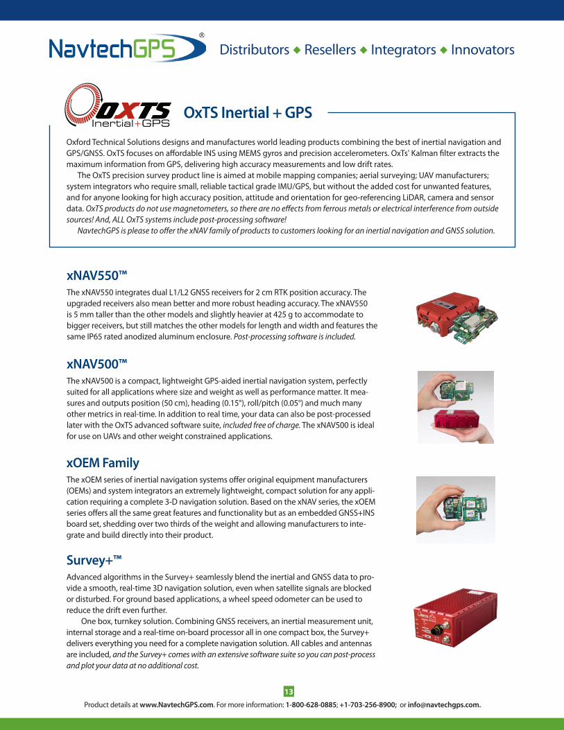
OxTS Inertial + GPS
xNAV500™the xnav500 is a compact, lightweight gps-aided inertial navigation system, perfectly suited for all applications where size and weight as well as performance matter. it mea-sures and outputs position (50 cm), heading (0.15°), roll/pitch (0.05°) and much many other metrics in real-time. in addition to real time, your data can also be post-processed later with the oxts advanced software suite, included free of charge. the xnav500 is ideal for use on uavs and other weight constrained applications.
xNAV550™the xnav550 integrates dual l1/l2 gnss receivers for 2 cm RtK position accuracy. the upgraded receivers also mean better and more robust heading accuracy. the xnav550 is 5 mm taller than the other models and slightly heavier at 425 g to accommodate to bigger receivers, but still matches the other models for length and width and features the same ip65 rated anodized aluminum enclosure. Post-processing software is included.
Survey+™advanced algorithms in the survey+ seamlessly blend the inertial and gnss data to pro-vide a smooth, real-time 3D navigation solution, even when satellite signals are blocked or disturbed. For ground based applications, a wheel speed odometer can be used to reduce the drift even further.
one box, turnkey solution. combining gnss receivers, an inertial measurement unit, internal storage and a real-time on-board processor all in one compact box, the survey+ delivers everything you need for a complete navigation solution. all cables and antennas are included, and the Survey+ comes with an extensive software suite so you can post-process and plot your data at no additional cost.
xOEM Familythe xoeM series of inertial navigation systems offer original equipment manufacturers (oeMs) and system integrators an extremely lightweight, compact solution for any appli-cation requiring a complete 3-D navigation solution. Based on the xnav series, the xoeM series offers all the same great features and functionality but as an embedded gnss+ins board set, shedding over two thirds of the weight and allowing manufacturers to inte-grate and build directly into their product.
oxford technical solutions designs and manufactures world leading products combining the best of inertial navigation and gps/gnss. oxts focuses on affordable ins using MeMs gyros and precision accelerometers. oxts' Kalman filter extracts the maximum information from gps, delivering high accuracy measurements and low drift rates.
the oxts precision survey product line is aimed at mobile mapping companies; aerial surveying; uav manufacturers; system integrators who require small, reliable tactical grade iMu/gps, but without the added cost for unwanted features, and for anyone looking for high accuracy position, attitude and orientation for geo-referencing liDaR, camera and sensor data. OxTS products do not use magnetometers, so there are no effects from ferrous metals or electrical interference from outside sources! And, ALL OxTS systems include post-processing software!
NavtechGPS is please to offer the xNAV family of products to customers looking for an inertial navigation and GNSS solution.
Product details at www.NavtechGPS.com. For more information: 1-800-628-0885; +1-703-256-8900; or [email protected].
Distributors Resellers Integrators Innovators
14
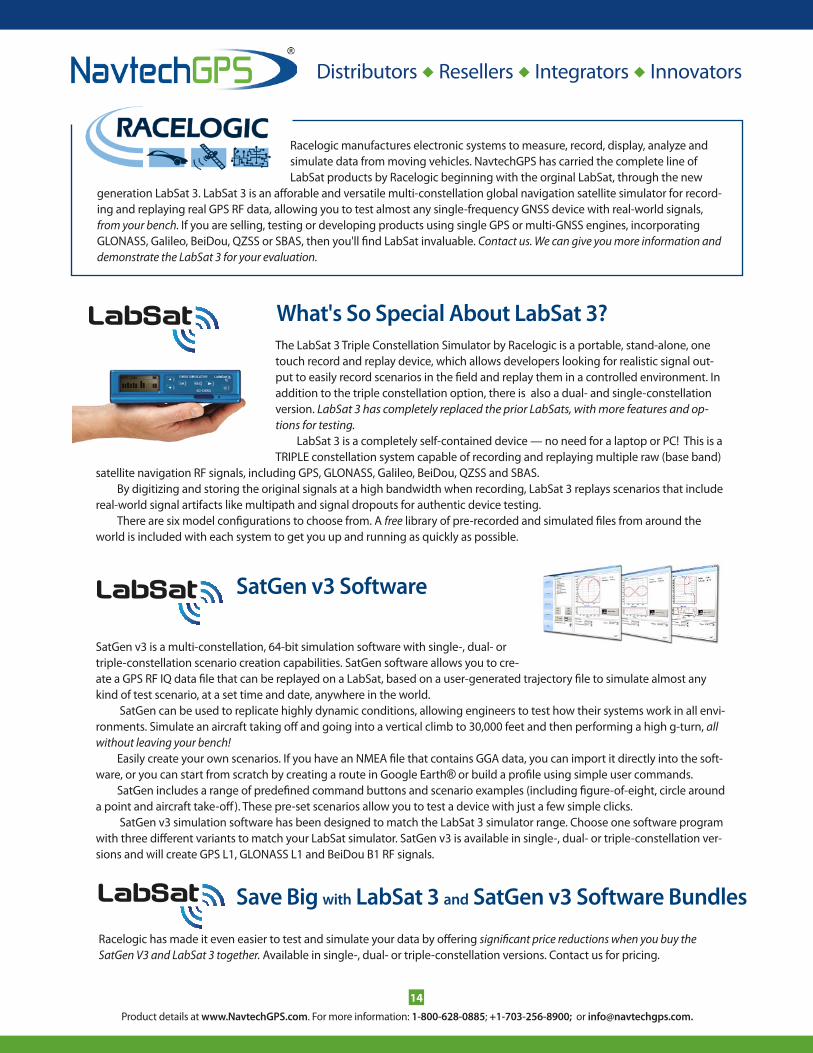
What's So Special About LabSat 3?
Save Big with LabSat 3 and SatGen v3 Software Bundles
satgen v3 is a multi-constellation, 64-bit simulation software with single-, dual- or triple-constellation scenario creation capabilities. satgen software allows you to cre-ate a gps RF iQ data file that can be replayed on a labsat, based on a user-generated trajectory file to simulate almost any kind of test scenario, at a set time and date, anywhere in the world.
satgen can be used to replicate highly dynamic conditions, allowing engineers to test how their systems work in all envi-ronments. simulate an aircraft taking off and going into a vertical climb to 30,000 feet and then performing a high g-turn, all without leaving your bench!
easily create your own scenarios. if you have an nMea file that contains gga data, you can import it directly into the soft-ware, or you can start from scratch by creating a route in google earth® or build a profile using simple user commands.
satgen includes a range of predefined command buttons and scenario examples (including figure-of-eight, circle around a point and aircraft take-off). these pre-set scenarios allow you to test a device with just a few simple clicks.
satgen v3 simulation software has been designed to match the labsat 3 simulator range. choose one software program with three different variants to match your labsat simulator. satgen v3 is available in single-, dual- or triple-constellation ver-sions and will create gps l1, glonass l1 and BeiDou B1 RF signals.
SatGen v3 Software
Racelogic manufactures electronic systems to measure, record, display, analyze and simulate data from moving vehicles. navtechgps has carried the complete line of labsat products by Racelogic beginning with the orginal labsat, through the new
generation labsat 3. labsat 3 is an afforable and versatile multi-constellation global navigation satellite simulator for record-ing and replaying real gps RF data, allowing you to test almost any single-frequency gnss device with real-world signals, from your bench. if you are selling, testing or developing products using single gps or multi-gnss engines, incorporating glonass, galileo, BeiDou, QZss or sBas, then you'll find labsat invaluable. Contact us. We can give you more information and demonstrate the LabSat 3 for your evaluation.
the labsat 3 triple constellation simulator by Racelogic is a portable, stand-alone, one touch record and replay device, which allows developers looking for realistic signal out-put to easily record scenarios in the field and replay them in a controlled environment. in addition to the triple constellation option, there is also a dual- and single-constellation version. LabSat 3 has completely replaced the prior LabSats, with more features and op-tions for testing.
labsat 3 is a completely self-contained device — no need for a laptop or pc! this is a tRiple constellation system capable of recording and replaying multiple raw (base band)
satellite navigation RF signals, including gps, glonass, galileo, BeiDou, QZss and sBas.By digitizing and storing the original signals at a high bandwidth when recording, labsat 3 replays scenarios that include
real-world signal artifacts like multipath and signal dropouts for authentic device testing.there are six model configurations to choose from. a free library of pre-recorded and simulated files from around the
world is included with each system to get you up and running as quickly as possible.
Racelogic has made it even easier to test and simulate your data by offering significant price reductions when you buy the SatGen V3 and LabSat 3 together. available in single-, dual- or triple-constellation versions. contact us for pricing.

Product details at www.NavtechGPS.com. For more information: 1-800-628-0885; +1-703-256-8900; or [email protected].
Distributors Resellers Integrators Innovators
15
septentrio products cover professional, industrial and scientific applications in precise gnss signal tracking, positioning and navigation. advanced hardware and sophisticated algorithms provide world-class performance, while well-engineered and standardized interface formats, complemented by an extensive command language, make for wide applicability and easy integration. NavtechGPS® is a distributor of the entire septentrio line, including the AsteRx3 and 4 line, which include Septentrio's Advanced Interference Mitigation (AIM+) technology to help mitigate GNSS signal interference. We also carry the full line of heading receivers utilizing iMu MeMs and gps interferometry for a gnss-only based heading.
AsteRx-MasteRx-m is a very low power gps/glonass dual-frequency RtK receiver smaller than a credit card, especially designed for hand-held devices, mobile computing platforms and other solutions requiring high accuracy in low-power and space-constrained applications.
PolaRxSthe polaRxs is a multi-frequency, multi-constellation receiver dedicated to iono-spheric monitoring and space weather applications that is designed around septentrio’s latest tracking engine and an ultra low noise oven-controlled crystal oscillator (ocXo).
AsteRx2eH ProasteRx2eh pRo is a single-board, dual-frequency dual-antenna gps/glonass heading receiver integrated in a water-proof aluminum housing, specially designed for demand-ing machine control, marine survey, photogrammetry and other multi-antenna applications.
PolaRx4 and 4TR Multi-frequency GNSS Reference Stationthe polaRx4 pro and 4tR family consists of a series of fully featured, high performance gnss receivers provid-ing network operators and scientific users with high-quality tracking and measurement of all available and upcoming gnss signals. innovative gnss signal processing, extensive networking capabilities, robust design and intuitive user interface make this family an excellent choice for a future-proof base station solution.
AsteRx4 OEM, Next-Generation Receiverthe asteRx4 oeM is a multi-frequency and multi-constellation dual antenna receiver that incorporates the latest gnss tracking and positioning algorithms from septentrio. the asteRx4 delivers the highest possible accuracy, scalable to a centimeter, while integrating the entire suite of septentrio gnss+ algo-rithms to maintain tracking during heavy vibration of machines and under difficult ionosphere condi-tions, and to mitigate or reject intentional or unintentional interference with gnss signals.
AsteRx-U4 and AsteRx-U Marinethe asteRx-u and the asteRx-u Marine are multi-constellation dual antenna receivers that incorpo-rate the latest gnss tracking and positioning algorithms and interference mitigation. Built around septentrio’s latest asic, the gReco4, the asteRx-u features built-in jamming detection and coun-termeasures, multi-path rejection and fast acquisition. it has over 500 channels to track all available constellations and has many of septentrio’s special algorithms, including locK+ technology to maintain tracking during heavy vibration and iono+ technology to assure position accuracy even in regions of elevated ionospheric activity.
AsteRx2eL with Full Support for Terrastar™the asteRx2el is an all-in-view dual-fre-quency gps/glonass receiver, featuring an integrated l-band modem to receive teRRastaR data trans-mitted by satellite and field-proven dm-accurate positioning using this data.
Septentrio OEM Receivers

Product details at www.NavtechGPS.com. For more information: 1-800-628-0885; +1-703-256-8900; or [email protected].
Distributors Resellers Integrators Innovators
16
High-Precision Positioning Solutionstrimble has unique systems and solutions that our customers are looking for. trimble develops high quality, high accuracy oeM boards and antennas that provide easy integration into your projects, whatever the application.
NavtechGPS® is a vaR (value added Reseller) for the entire trimble high-precision oeM line including l1, l1/l2, l5, glonass, sBas, inertial, and more. trimble products can leverage the strong network of existing community base stations around the globe and support many external sensors via a variety of interfaces available on board many of their oeM prod-ucts. product uses included unmanned systems, defense systems, mapping, machine control, asset tracking, mining and much more. here is a sampling of the trimble products we offer.
Trimble BD920-W3G GNSS Receiver, Bluetooth/Wi-Fi/3.5Gthe BD920-W3g gnss receiver module has been designed for applications requiring centimeter accuracy in a compact package. By integrating wireless communications on the same module, receiving and trans-mitting data such as RtK corrections is greatly simplified. a single intuitive Web interface allows a variety of use cases to be supported. in addition to gnss base and rover setups with Wi-Fi or uMts modem, the mod-ule also allows simultaneous customer access to the internet. Both gnss and communication components are fully shielded. this design ensures the signals are protected from sources of eMi on the host platform.
The BD930-UHF GNSS Receiverthe BD930-uhF gnss receiver supports both triple frequency from the gps and glonass constellations, and dual frequency from BeiDou and galileo. the BD930 delivers fast and reliable RtK initializations for 1 to 2 centimeter positioning. For applications that do not require centimeter accuracy, the BD930-uhF contains an advanced Kalman filter pvt engine that delivers high accuracy gnss, Dgnss positions in chal-lenging environments, such as urban canyons.
Different configurations are available from a Dgps l1 unit to a four-constellation triple frequency RtK unit. all features are password upgradeable. the receiver also supports Fault Detection and exclusion (FDe) and Receiver autonomous integrity Monitoring (RaiM) for safety-critical applications.
BD970 GNSS System: Compact Low-Power GPS Receiverthe BD970 gnss system is a compact multi-constellation receiver designed to deliver centimeter accu-racy to a variety of applications. With the BD970, oeMs and integrators can be assured their investment is sound today and into the future. the BD970 gnss receiver suports a wide range of satellite signals, including gps l2c and l5 and glonass l1/l2 signals.
BX982 GNSS Receiver Enclosure (BD982 Receiver Inside)the trimble BX982 gnss receiver enclosure is a multi-channel, multi-frequency oeM gnss receiver that allows oeMs and system integrators to rapidly integrate centimeter-level positioning and precise heading into their applications. the BX982 supports gps l1/l2/l5 and glonass l1/l2 signals. the BX982 packages a single BD982 receiver module in a rugged environmentally sealed enclosure that is easy to install.
MB-Two GNSS Receiver Module*the trimble MB-two is the successor to the trimble MB-one oeM receiver module.the MB-two main-tains the identical form-factor as its predecessor and offers customers a drop-in replacement to utilize the latest gnss design innovations.
the trimble® MB-two is versatile, powerful, compact and smart. the trimble MB-two provides faster Dual Frequency based heading acquisition and an improved positioning engine with additional gnss signals. in addition two MB-two modules may be used for precise platform position (p3) using data from three antennas for full gnss attitude.
*Ask us about available evaluation kits.

Product details at www.NavtechGPS.com. For more information: 1-800-628-0885; +1-703-256-8900; or [email protected].
Distributors Resellers Integrators Innovators
17
High-Precision Positioning Solutionstrimble develops high quality, high accuracy oeM boards and antennas that provide easy integration into your projects, whatever the application. here are some more great trimble products.
MB-One GNSS Receiver Module*the MB-one by trimble (formerly ashtech) delivers highly accurate gnss-based heading plus pitch or roll for high-performance centimeter-level positioning and heading in a miniature power-saving de-sign. the embedded Z-Blade™ gnss technology uses all available gnss signals equally, without any constellation preference for fast and stable solutions. the MB-one features gnss and RtK technology for a wide variety of unique applications, such as unmanned, agriculture, marine and military systems.
the MB-one has an enhanced dual-core gnss engine with 240 channels capable of tracking a large range of gnss systems including gps, glonass, galileo and BeiDou. it utilizes over-the-air sat-ellite corrections using l-Band hardware to achieve decimeter-level accuracy. this module is capable of receiving and decoding precise point positioning (ppp) for an accurate position solution that elimi-nates the need for a local base station.
Zephyr Geodetic 2 Antenna and the Zephyr 2 GNSSthe trimble Zephyr geodetic 2 antenna is designed to receive all existing and proposed public gnss signals, including gps, glonass, galileo and compass (BeiDou). these antennas are used in the highest-accuracy igs reference frame networks where only the best possible long-term performance is accepted.
Trimble AV59 Aviation GNSS Antennathe av59 is designed to support centimeter level accuracy for aerial, land and marine applications. the bulkhead mounting supports use in rugged environments and resists unwanted signal interference or multipath, which can cause inaccurate measurements. the aviation design and bulkhead mounting ensure that only the rugged radome is exposed to the elements, which is ideal design for machine control systems.
The Trimble LV59 Aviation GNSS Antennathe lv59 aviation gnss antenna has been designed to support centimeter level accuracy for land and ma-rine applications. the rugged 5/8" x 11 female threaded mount and all aluminum base allows the antenna to be used in the most rugged of environments. like the av59, the antenna offer robust low multipage to resist unwanted multipath signal interference. however this antenna is a survey rover type of design, ideal for customers building systems that require easy removal of the antenna.
The Trimble AV37 GNSS and L-Band Aviation Antennathe trimble av37 aviation antenna has been designed to support centimeter level accuracy for airborne applications and track sBas signals all in one compact design. it is fully certified by the Faa for aircraft in-stallations. Mapping and surveying from the air using gnss requires survey grade antenna technology in a compact and reliable form factor. the trimble av37 gnss aviation antenna achieves this without compro-mising performance.
*Ask us about available evaluation kits.

Product details at www.NavtechGPS.com. For more information: 1-800-628-0885; +1-703-256-8900; or [email protected].
Distributors Resellers Integrators Innovators
18
Survey, Attitude, Heading, GIS, OEMBoasting one of the widest varieties of receiver types , including out-of-the box systems and oeM, spectra precision has you covered in just about any environment. spectra precision has a full line of oeM boards from the dual frequency MB500 gps/glonass to the ac12 l1 boards. the newly added proFlex light Duo enters spectra precision into the gnss heading mar-ket. Drawing from many years of experience of attitude positioning with the aDu line, ashtech/spectra precision has added dual frequency heading coupled with RtK and more. ashtech/spectra precision continues to be a leader in the gis market as well. the proMark 3, MobileMapper 6 and MobileMapper cX continue to give an all-in-the-hand survey and gis package for economical ease of use on a large or small scale.
give us a call so we can configure a system to suit your needs. (See next page for more great products from Spectra Precision powered by Ashtech.)
Spectra Precision ProMark™ 800 GNSS Receiver the proMark™ 800 is an extremely productive and reliable RtK solution delivering precise gnss positioning in a smart, rugged and cable-free design. the new Z-Blade gnss centric technology optimally uses gnss signals and takes advantage of each gnss constellation to deliver fast and stable RtK positions, even when gps coverage is insufficient, like in urban canyons or heavy tree canopy. it includes extended wireless network communications modules, for maximum mobility and flexibility in the field.

Product details at www.NavtechGPS.com. For more information: 1-800-628-0885; +1-703-256-8900; or [email protected].
Distributors Resellers Integrators Innovators
19
VN-200 OEM SMD Inertial Navigation Systemthe vn-200 oeM (also known as the vn-200 sMD inertial navigation system) is a min-iature, surface mount, high-performance gps-aided inertial navigation system (gps/ins). incorporating the latest MeMs sensor technology, the vn-200 oeM combines 3-axis accelerometers, gyros, magnetic sensors, a barometric pressure sensor, a high-sensitivity gps receiver and advanced Kalman filtering algorithms to provide optimal estimates of position, velocity, and orientation.
VN-100 SMD Orientation Sensorthe vectornav vn-100 oeM (also known as the vn-100 sMD orientation sensor) is a min-iature, surface mount, high-performance inertial measurement unit (iMu) and attitude heading reference system (ahRs). incorporating the latest MeMs sensor technology, the vn-100 oeM combines 3-axis accelerometers, gyros, magnetic sensors, and an optional barometric pressure sensor into a miniature surface mount module.
VN-200 Rugged™ INSthe vn-200 Rugged (also known as the vn-200 Rugged inertial navigation system) is a miniature gps-aided inertial navigation system (gps/ins) that provides an off-the-shelf, high-performance inertial navigation sensing solution. incorporating the latest MeMs sensor technology, the vn-200 Rugged combines 3-axis accelerometers, gyros, magnetic sensors, a barometric pressure sensor and a high-sensitivity gps received into a light-weight, robust aluminum enclosure.
VN-100 Rugged™ Orientation Sensorthe vn-100 Rugged (also known as the vn-100 Rugged orientation sensor) is a miniature inertial Measurement unit (iMu) and attitude heading Reference system (ahRs) that pro-vides an off-the-shelf, high-performance inertial sensing solution. incorporating the lat-est MeMs sensor technology, the vn-100 Rugged combines 3-axis accelerometers, gyros, magnetic sensors, and an optional barometric pressure sensor into a lightweight, robust aluminum enclosure.
VectorNav TechnologiesVectorNav Technologies specializes in manufacturing high-performance navigation and inertial sensors using the latest miniature MeMs inertial sensor technology, including miniature MeMs inertial measurement units (iMus), attitude heading Reference systems (ahRs), and inertial sensors and the first gps-aided ins on a chip. vectornav brings high performance aerospace filtering and calibration techniques into the world of low-cost industrial grade MeMs sensors, expanding the pos-sibilities of today’s MeMs sensor technology. Ask us about available development kits!
VN-300 Dual Antenna GPS-Aided INS the vn-300 is a miniature Dual antenna gps-aided inertial navigation system (gps/ins) that provides gps heading and roll or pitch backed by MeMs 3-axis sensors for an off-the-shelf, high-performance inertial navigation sensing solution. With the latest MeMs sensor technology, the vn-300 combines 3-axis accelerometers, gyros, magnetic sensors, a barometric pressure sensor and two gps receivers into a lightweight, robust aluminum enclosure.

Product details at www.NavtechGPS.com. For more information: 1-800-628-0885; +1-703-256-8900; or [email protected].
20
Peripherals Peripherals Peripherals
Equipment for Survey and GIS
Heading and Attitude Systems
Signal Splitters, Amplifiers and Signal Distribution ProductsNavtechGPS® carries a range of gnss signal splitters, amplifiers, attenuators, combiners and Dc blocks. We carry full lines from gps networking, Forsberg services ltd. (starlink line) and tallysman Wireless. signal splitters have a single antenna input and are available with 2, 4 or 8 outputs. Rack-mount configurations of 1x16 and 1x32 are also available. amplifiers range in gain from 1-20dB with options for adjustable gain. Fiber optic signal distribution systems and auto-switching signal splitters are available and are growing in use for telecom applications.
Attention Military Users: gps networking's ruggedized splitters have been tested and certified to military specifica-tions. these products are specifically designed for military applications and are hermetically sealed, eMi shielded, and virtually indestructible. contact us for product details, certification and testing information and pricing.
Do you need accurate heading or attitude measurements? We have a line of products for that. Do you need an oeM or boxed solution? We can recommend the right product for your needs. We carry single- and dual-frequency heading and atti-tude systems from leading manufactures that include ashtech powered by trimble, hemisphere gps, navcom, novatel, septentrio and trimble. these systems have a range of sizes, antenna types and prices.
let us know what your application is, and we will recom-mend a solution.
NavtechGPS® has the hardware you'll need to complete any survey or gis task. We carry single- or dual-frequency systems, rugged data collection units and all accessories. our survey and gis line includes the hemisphere s320, to use with your existing data col-lectors. complete RtK systems for survey include the land-pak from navcom and the proMark 800 system from spectra precision, powered by ashtech.

Product details at www.NavtechGPS.com. For more information: 1-800-628-0885; +1-703-256-8900; or [email protected].
21
Peripherals Peripherals Peripherals
NavtechGPS® is an authorized reseller of the omnistaR satellite based differential correction service. omnistaR® is avail-able worldwide and eliminates your reliance on base stations for accurate positioning. there are subscription options avail-able for different areas of the planet, levels of accuracy and different durations. We will help you decide. We currently carry omnistaR-ready equipment from hemisphere gnss.
OmniSTAR Subscription: Freedom from Base Stations!
FreeWave Spread Spectrum Radios and Board-Level Products
the FgR2 series represents the next generation of the new spread spectrum radio modems from FreeWave, allowing customers to incorporate cost-effective wireless communications into a variety of applications. offered as both a board-level product and in an enclosure, the FgR2 provides tre-mendous flexibility for use in applications ranging from oil and gas to golf carts, water systems and more. the FgR2 is also backward compatible with the FgR and DgR series. NavtechGPS® offers the FgR2 as a board-level product or in an enclosure with a mounting shoe. no license is required for use within the united states.
in addition to one of the best spread spectrum packaged radios in the industry, FreeWave also has an extensive line of oeM radios and antennas, such as the FreeWave MM2 900 Mhz mini data radio. call us for more on these products.
NavtechGPS® carries the complete line of pacific crest advanced Data link (aDl) modules and accessories, including the XDl Rover 2, for wireless precise positioning and remote sensing. these broad spectrum transceivers offer up to 35 Watts of power and over-the-air link rates as high as 19,200 bps. the rapidly growing line of aDl products include: the aDl vantage pro, a 35-Watt programmable uhF radio; the aDl vantage, a 4-Watt programmable uhF radio for survey applications; the aDl sentry, a 4-Watt radio for remote sensing and monitoring environments; the aDl Foundation, a transceiver oeM board; the aDl RXo, a receive-only oeM board; the aDl uplink, a ruggedized handheld computer that streams internet-based RtK corrections to a radio for rebroad-cast into areas of poor cell coverage, and the XDl Rover 2, a lightweight, ruggedized uhF receiver for commu-nications between 403 and 473 Mhz in either 12.5 or 25 khz channels. let us help you select the best option for your project.
Pacific Crest Radios and Modems
AtlasLink and Atlasatlaslink™ is a versatile multi-frequency smart antenna from hemisphere gnss that is preconfig-ured to receive corrections from the new atlas gnss global correction service. atlaslink offers hemisphere gnsss' athena gnss engine; l-Band 10 cm corrections; l1 l2, RtK; a powerful Web user interface accessible via WiFi; Built-in internal memory for data logging, download and upload, and an enclosure for the most aggressive user scenarios.

Product details at www.NavtechGPS.com. For more information: 1-800-628-0885; +1-703-256-8900; or [email protected].
22
Antennas Antennas Antennas Antennas
chances are, NavtechGPS® has an antenna for your application and can match an antenna to your receiver. We carry anten-nas by antcom, pctel, panasonic, hemisphere, navXperience, novatel, tallysman and others. We stock a wide variety of single and dual frequency and multi-constellation antennas.
Antennas
High Performance, High Quality GNSS Antennas
New Rugged, Light & Accurate GNSS Antennathese next-generation gnss antenna products have been devel-oped by navXperience with a future-proof technology that meet or exceed phase center eccentricity standards of up to 1 mm. the navXperience 3g+c antennas offer superior performance and durability for many applications, including reference (surveying), agriculture, navigation, marine and machine control.
Leading Edge Antennas for an Array of Applicationsantcom excels in the design, development, manufacture and testing of a wide range of antenna and microwave products. We deliver leading edge solutions to customers developing applications for the agricultural, aviation, military, ground, ma-rine, and space industries. our extensive antenna product line includes global navigation satellite system (gnss) antennas as well as those with frequencies ranging from 100 Mhz to 12 ghz. Whatever your antenna requirement — uhF, iridium, globalstar, inMarsat, thuraya, XM, ico, video/Data link or l/s/c/X-Band — we have the ideal solution for your unique application.
tallysman Wireless is a developer of high performance, dual-feed, high quality gnss antennas, including brick wall antennas for out of
l1 high band rejection, for professional tracking and timing applications. the line includes precision grade gps, glonass, galileo, globalstar, iridium, sBas, l-band (omnistar™, starFire™, Dgps) and custom global positioning antennas, which meet or exceed industrial and military specifications.
tallysman has developed a unique alternative to choke-ring antennas through its patented veraphase technology. the performance of the veraphase™ is designed to rival that of geodetic / reference antennas, including choke ring antennas, but is lighter, smaller and more economical.

Product details at www.NavtechGPS.com. For more information: 1-800-628-0885; +1-703-256-8900; or [email protected].
23
MATLAB® Toolboxes MATLAB® Toolboxes
Engineering/Development Software
INS Toolbox 3.0™ for MATLAB® from GPSoft®an official MatlaB® partner product, Gpsoft® expanded on the highly success-ful satnav toolbox™ with the ins toolbox for matLaB®. the ins toolbox provides the
necessary functions to emulate a wide variety of inertial sen-sors from Rlg’s and Fog’s down to MeMs sensors via user-defined sensors errors such as biases, scale factor error and noise. the ins toolbox is fully compatible with the gpsoft satnav toolbox and both are utilized in gpsoft’s navigation system integration & Kalman Filter toolbox.
SatNav Toolbox 3.0™ for MATLAB® from GPSoft®now the power of the satnav toolbox is extended with real data processing! import ephemeris and measurement data (pseudorange and carrier-phase) in RineX2 format. perform simulations in
your lab or office right now! gpsoft® has applied the power of MatlaB® to gnss (global navigation satellite system). this toolbox allows the user to emulate the c/a-code on l1, l2, l5 and any other user defined frequency. in addition, the toolbox can be used to simulate p-code on l1 and l2. Also with support for Galileo!
Navigation System Integration & Kalman Filter Toolbox™ for MATLAB® from GPSoft®this toolbox extends the capabilities of the gpsoft® satnav and ins toolboxes by pro-viding the Kalman filter algorithms used to achieve maximum performance. among these are gps stand-alone 8-state and 11-state
extended Kalman filters, inertial error modeling in state-space, loosely integrated ins/gps Kalman filters.
M-KF Toolbox Software for MATLAB® from L3NAVM-KF tool is a library of MatlaB® M-file modules and main programs for the im-plementation of discrete Kalman filtering applications. simulate a specific applica-tion quickly and easily without the need
to code and test the basic Kalman filtering algorithms or to provide direct hookups to individual receivers.
GPS Toolbox Software for MATLAB® from L3NAVgps toolbox v5 is a library of MatlaB® M-file modules and programs used for the implementation of gps applications. gps toolbox enables you to simulate a specific gps application quickly and easily with-
out the need to code and test the basic gps algorithms.
NavtechGPS® has the navigation simulation and analysis software you need — in stock and ready to ship. give us a call.
RINEX & SP3 (RAS) Software Toolbox for MATLAB®, L3NAVthe gps RineX and sp3 software toolbox for MatlaB® is a library of m-file modules and programs performing basic data processing frequently encountered in gps RineX and sp3 related engineering calculations. the user can modify existent
m-files to suit a specific application without the need of implementing elementary building blocks that are included in this toolbox.
Coordinate Transformations (CT) Software Toolbox for MATLAB® from L3 NAVthe key features of this toolbox are the utm and ups coordinate transformations: a low cost solution for coordinate trans-formation. additional features include angle transformations, point coordinate
transformations, matrix coordinate transformations, vector coordinate transformations and flexible modules, ready to be incorporated in user’s applications.

www.NavtechGPS.com • 800.628.0885 • +1.703.256.8900 • Woman-Owned Small Business
v041
516
YOUR ONE SOURCE FOR GNSS EQUIPMENT AND TRAINING