Deforestation in amazon
17
Course Project : CE-287 Geo informatics DEFORESTATION IN AMAZON
-
Upload
muhammad-farhan -
Category
Environment
-
view
37 -
download
0
Transcript of Deforestation in amazon

Course Project : CE-287 Geo
informatics
DEFORESTATION IN
AMAZON

INTRODUCTION
AREA= AMAZON (RIO BRANCO,BRAZIL)
The Amazon rainforest is the world’s largest tropical
rainforest, famed for its bio diversity. The
rainforest is seen as a resource for cattle pasture,
valuable hardwoods, housing space, farming
space, road works and medicines. Scientists
using NASA satellite data found in 2006 that
clearing for mechanized cropland had become a
significant force in Brazilian Amazon
deforestation. This change in land use may alter
the region's climate

We collected the datasets i.e. images from the
internet. The datasets were then analyzed in
ERDAS IMAGINE. By interpreting the images the
deforestation was evident. Images were digitized
for ease of analysis.

RIO BRANCO, AMAZON

ABSTRACT:
We used Erdas Imagine 2013 to observe the
deforestation of Amazon Forest by taking in
account its particular area of Rio Branco having
latitude 9˚ 58’ 31’’ and longitude 67˚ 49’ 29’’. We
took the datasets from internet
(earthexplorer.usgs.gov), performed stacking,
subsetting, georeferencing, area calculations, and
used other such tools to observe the
deforestation of particular area and its conversion
for nonforest use.

Targeted Amenities
FORESTED AREA
CLEARED OR DEFORESTED AREA
BUILT UP AREA
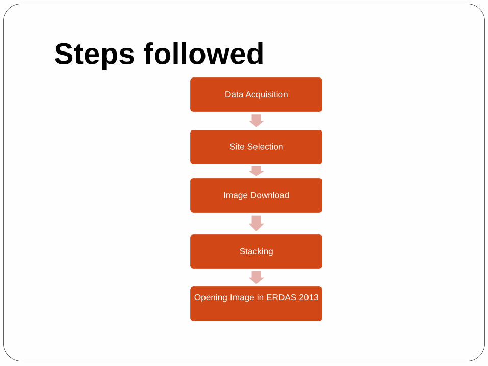
Steps followedData Acquisition
Site Selection
Image Download
Stacking
Opening Image in ERDAS 2013

Steps followedClassification Using different techniques
Calculation of area
Checking Deforestation
Concluding regarding observations
Prediction Of Deforestation in 2030

1990 NDVI IMAGE
Supervised classified NDVI image

(Area selection ) 2000

Step 2: (NDVI) Image 2000

Supervised Classified Image
2000
GREEN Color =VegetationBLACK =Built up
and all other areas

2015

AREA OF VEGETATION=11122.2 Sq. miles
1990 Results

AREA OF VEGETATION=10419.4 Sq. miles
2010 Results

RESULTS
% change in Vegetation =11122.2−10419.4
11122.22
*100
=6.31%
So 6.31% of vegetation is lost due to
deforestation from 1990 to 2000

Prediction
According to results and data calculated a rough
estimate is that as exponential growth of human
population is also a factor if Reforestation is not
done 40% of the forest will be lost by 2030