
DeCelles Servier Thrust
24
For permission to copy, contact [email protected] © 2006 Geological Society of America 841 GSA Bulletin; July/August 2006; v. 118; no. 7/8; p. 841–864; doi: 10.1130/B25759.1; 12 figures. ABSTRACT The Canyon Range, Pavant, Paxton, and Gunnison thrust systems in central Utah form the Sevier fold-and-thrust belt in its type area. The Canyon Range thrust carries an ~12-km-thick succession of Neoprotero- zoic through Triassic sedimentary rocks and is breached at the surface by the Neogene extensional Sevier Desert detachment fault. The Pavant, Paxton, and Gunnison thrusts carry Lower Cambrian through Cretaceous strata and have major footwall detachments in weak Jurassic rocks. The Canyon Range thrust was active during latest Jurassic–Early Cretaceous time. The Pavant thrust sheet was emplaced in Albian time, formed an internal duplex beneath the Canyon Range during the Cenomanian, and then developed a fron- tal duplex during the Turonian. The Paxton thrust sheet was initially emplaced during the Santonian, and subsequently formed the Paxton duplex during the early to mid-Cam- panian. Some slip on the Paxton system was fed into a frontal triangle zone along the San- pete Valley antiform. The Gunnison thrust system became active in late Campanian time and continued to feed slip into the fron- tal triangle zone through the early Paleocene. The Canyon Range and main Pavant thrust sheets experienced long-distance eastward transport (totaling >140 km) mainly because they are composed of relatively strong rocks, whereas the eastern thrust sheets accom- modated less shortening and formed mul- tiple antiformal duplexes in order to main- tain sufficient taper for continued forward propagation of the fold-and-thrust belt. Total shortening was at least 220 km. Upper crustal thickening of ~16 km produced crust that was >50 km thick and a likely surface elevation >3 km in western Utah. Shorten- ing across the entire Cordilleran retroarc thrust belt at the latitude of central Utah may have exceeded 335 km. The Late Cretaceous paleogeography of the fold-and-thrust belt and foreland basin was similar to the modern central Andean fold-and-thrust belt, with a high-elevation, low-relief hinterland plateau and a rugged topographic front. The frontal part of the Sevier belt was buried by sev- eral kilometers of nonmarine and shallow- marine sediments in the wedge-top depozone of the foreland basin system. The Canyon Range thrust sheet dominated sediment sup- ply throughout the history of shortening in the Sevier belt. Westward underthrusting of a several hundred-kilometer-long panel of North American lower crust beneath the Cordilleran magmatic arc is required to bal- ance upper-crustal shortening in the thrust belt, and may be petrogenetically linked to a Late Cretaceous flare-up of the magmatic arc as preserved in the Sierra Nevada Batholith. Keywords: Cordilleran tectonics, fold-and- thrust belts, foreland basins, Utah. INTRODUCTION The Sevier fold-and-thrust belt in central Utah (western interior USA) is the type area of one of the world’s classic fold-and-thrust belts and was among the first to be systematically character- ized in terms of modern concepts of thrust-belt geology and geophysics (Armstrong and Oriel, 1965; Armstrong, 1968; Dahlstrom, 1970; Royse et al., 1975; Burchfiel and Davis, 1975; Lamerson, 1982; Allmendinger et al., 1983, 1986, 1987; Smith and Bruhn, 1984). Armstrong (1968) defined the Sevier belt as the linear group of closely spaced thrust faults and related folds that extends from th e Las V egas, Nevada, area to the Idaho state line (Fig. 1). Subsequent work by many authors has shown that contemporaneous thrust systems (in the sense of Boyer and Elliott, 1982) continue for ~3000 km to the north into northwestern Canada. Thus, the Sevier belt may be regarded as a segment of the larger Cordille- ran retroarc fold-and-thrust belt (Fig. 1), which formed during late Mesozoic through Eocene time along the inboard side of the Cordilleran magmatic arc and various allochthonous ter- ranes (see reviews by Burchfiel et al., 1992; All- mendinger, 1992; Miller et al., 1992; Dickinson, 2004; DeCelles, 2004). Although many of the geometric details of the Sevier belt in central Utah are well docu- mented, the regional kinematic history and the relationships between shortening in the Sevier belt and tectonic processes in the Cordilleran magmatic arc and hinterland region remain obscure. The most recent synthesis of regional structure and kinematic history in the Sevier belt of central Utah is now nearly two decades old (Villien and Kligfield, 1986). Numerous more recent studies have provided abundant new information on the structural geology, kine- matic history, and erosional unroofing history of the region (e.g., Royse, 1993; DeCelles et al., 1995; Lawton et al., 1997; Mitra, 1997; Stockli et al., 2001; Currie, 2002; Hintze and Davis, 2002, 2003; Ismat and Mitra, 2001, 2005), such that a revised synthesis is overdue. The purpose of this paper is to provide such a synthesis. We draw upon subsurface data, new mapping, new chronostratigraphic constraints on the ages of proximal synorogenic sediments derived from the Sevier belt, and recent thermochronological studies to develop a sequential kinematic resto- ration of the fold-and-thrust belt. The regional balanced cross section that forms the basis for this restoration was constructed using a com- bination of GeoSec and LithoTect software. Thrust-related deformation was modeled using a flexural slip algorithm for fault-bend folds. Regional structure and kinematic history of the Sevier fold-and-thrust belt, central Utah Peter G. DeCelles † Department of Geosciences, Univers ity of Arizona, T ucson, Arizona 85721, USA James C. Coogan ‡ Department of Geology , W estern State Colleg e of Colorado, Gunnison, Colorado 81231, USA † E-mail: [email protected] a.edu. ‡ E-mail: jcoogan@wes tern.edu.
-
Upload
nicholas-matthew-welsh -
Category
Documents
-
view
220 -
download
0
Transcript of DeCelles Servier Thrust

8/22/2019 DeCelles Servier Thrust
http://slidepdf.com/reader/full/decelles-servier-thrust 1/24
For permission to copy, contact [email protected]
© 2006 Geological Society of America84
GSA Bulletin; July/August 2006; v. 118; no. 7/8; p. 841–864; doi: 10.1130/B25759.1; 12 figures.
ABSTRACT
The Canyon Range, Pavant, Paxton, and
Gunnison thrust systems in central Utah
form the Sevier fold-and-thrust belt in its
type area. The Canyon Range thrust carries
an ~12-km-thick succession of Neoprotero-
zoic through Triassic sedimentary rocks and
is breached at the surface by the Neogene
extensional Sevier Desert detachment fault.
The Pavant, Paxton, and Gunnison thrusts
carry Lower Cambrian through Cretaceous
strata and have major footwall detachments
in weak Jurassic rocks. The Canyon Range
thrust was active during latest Jurassic–Early
Cretaceous time. The Pavant thrust sheet was
emplaced in Albian time, formed an internal
duplex beneath the Canyon Range during
the Cenomanian, and then developed a fron-
tal duplex during the Turonian. The Paxtonthrust sheet was initially emplaced during
the Santonian, and subsequently formed the
Paxton duplex during the early to mid-Cam-
panian. Some slip on the Paxton system was
fed into a frontal triangle zone along the San-
pete Valley antiform. The Gunnison thrust
system became active in late Campanian
time and continued to feed slip into the fron-
tal triangle zone through the early Paleocene.
The Canyon Range and main Pavant thrust
sheets experienced long-distance eastward
transport (totaling >140 km) mainly because
they are composed of relatively strong rocks,
whereas the eastern thrust sheets accom-
modated less shortening and formed mul-
tiple antiformal duplexes in order to main-
tain sufficient taper for continued forward
propagation of the fold-and-thrust belt.
Total shortening was at least 220 km. Upper
crustal thickening of ~16 km produced crust
that was >50 km thick and a likely surface
elevation >3 km in western Utah. Shorten-
ing across the entire Cordilleran retroarc
thrust belt at the latitude of central Utah may
have exceeded 335 km. The Late Cretaceous
paleogeography of the fold-and-thrust belt
and foreland basin was similar to the moderncentral Andean fold-and-thrust belt, with a
high-elevation, low-relief hinterland plateau
and a rugged topographic front. The frontal
part of the Sevier belt was buried by sev-
eral kilometers of nonmarine and shallow-
marine sediments in the wedge-top depozone
of the foreland basin system. The Canyon
Range thrust sheet dominated sediment sup-
ply throughout the history of shortening in
the Sevier belt. Westward underthrusting
of a several hundred-kilometer-long panel
of North American lower crust beneath the
Cordilleran magmatic arc is required to bal-ance upper-crustal shortening in the thrust
belt, and may be petrogenetically linked to a
Late Cretaceous flare-up of the magmatic arc
as preserved in the Sierra Nevada Batholith.
Keywords: Cordilleran tectonics, fold-and-
thrust belts, foreland basins, Utah.
INTRODUCTION
The Sevier fold-and-thrust belt in central Utah
(western interior USA) is the type area of one of
the world’s classic fold-and-thrust belts and was
among the first to be systematically character-
ized in terms of modern concepts of thrust-belt
geology and geophysics (Armstrong and Oriel,
1965; Armstrong, 1968; Dahlstrom, 1970;
Royse et al., 1975; Burchfiel and Davis, 1975;
Lamerson, 1982; Allmendinger et al., 1983,
1986, 1987; Smith and Bruhn, 1984). Armstrong
(1968) defined the Sevier belt as the linear group
of closely spaced thrust faults and related folds
that extends from the Las Vegas, Nevada, area to
the Idaho state line (Fig. 1). Subsequent work by
many authors has shown that contemporaneou
thrust systems (in the sense of Boyer and Elliott
1982) continue for ~3000 km to the north into
northwestern Canada. Thus, the Sevier belt may
be regarded as a segment of the larger Cordille
ran retroarc fold-and-thrust belt (Fig. 1), which
formed during late Mesozoic through Eocene
time along the inboard side of the Cordilleran
magmatic arc and various allochthonous ter
ranes (see reviews by Burchfiel et al., 1992; All
mendinger, 1992; Miller et al., 1992; Dickinson
2004; DeCelles, 2004).
Although many of the geometric details o
the Sevier belt in central Utah are well docu
mented, the regional kinematic history and the
relationships between shortening in the Sevie
belt and tectonic processes in the Cordilleran
magmatic arc and hinterland region remain
obscure. The most recent synthesis of regionastructure and kinematic history in the Sevier
belt of central Utah is now nearly two decade
old (Villien and Kligfield, 1986). Numerou
more recent studies have provided abundan
new information on the structural geology, kine
matic history, and erosional unroofing history o
the region (e.g., Royse, 1993; DeCelles et al.
1995; Lawton et al., 1997; Mitra, 1997; Stockl
et al., 2001; Currie, 2002; Hintze and Davis
2002, 2003; Ismat and Mitra, 2001, 2005), such
that a revised synthesis is overdue. The purpose
of this paper is to provide such a synthesis. We
draw upon subsurface data, new mapping, new
chronostratigraphic constraints on the ages o
proximal synorogenic sediments derived from
the Sevier belt, and recent thermochronologica
studies to develop a sequential kinematic resto
ration of the fold-and-thrust belt. The regiona
balanced cross section that forms the basis fo
this restoration was constructed using a com
bination of GeoSec and LithoTect software
Thrust-related deformation was modeled using
a flexural slip algorithm for fault-bend folds
Regional structure and kinematic history of the Sevier fold-and-thrust belt,
central Utah
Peter G. DeCelles†
Department of Geosciences, University of Arizona, Tucson, Arizona 85721, USA
James C. Coogan‡
Department of Geology, Western State College of Colorado, Gunnison, Colorado 81231, USA
†E-mail: [email protected].‡E-mail: [email protected].
8/22/2019 DeCelles Servier Thrust
http://slidepdf.com/reader/full/decelles-servier-thrust 2/24
DeCelles and Coogan
842 Geological Society of America Bulletin, July/August 2006
The sequential restoration combined line-length
and area balancing techniques that ensure <5%
error between deformed- and restored-state
cross-sectional areas for all stratigraphic levels.
The results of this study have implications for
the history of the adjacent Cordilleran foreland
basin, the Cordilleran magmatic arc to the west,
and crustal thickening and elevation gain in the
central part of the orogenic belt.
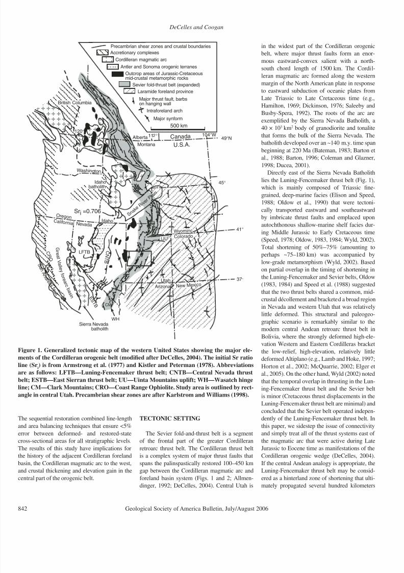
TECTONIC SETTING
The Sevier fold-and-thrust belt is a segment
of the frontal part of the greater Cordilleran
retroarc thrust belt. The Cordilleran thrust belt
is a complex system of major thrust faults that
spans the palinspastically restored 100–450 km
gap between the Cordilleran magmatic arc and
foreland basin system (Figs. 1 and 2; Allmen-
dinger, 1992; DeCelles, 2004). Central Utah is
in the widest part of the Cordilleran orogenic
belt, where major thrust faults form an enor-
mous eastward-convex salient with a north-
south chord length of 1500 km. The Cordil-
leran magmatic arc formed along the western
margin of the North American plate in response
to eastward subduction of oceanic plates from
Late Triassic to Late Cretaceous time (e.g.,Hamilton, 1969; Dickinson, 1976; Saleeby and
Busby-Spera, 1992). The roots of the arc are
exemplified by the Sierra Nevada Batholith, a
40 × 103 km2 body of granodiorite and tonalite
that forms the bulk of the Sierra Nevada. The
batholith developed over an ~140 m.y. time span
beginning at 220 Ma (Bateman, 1983; Barton et
al., 1988; Barton, 1996; Coleman and Glazner,
1998; Ducea, 2001).
Directly east of the Sierra Nevada Batholith
lies the Luning-Fencemaker thrust belt (Fig. 1),
which is mainly composed of Triassic fine-
grained, deep-marine facies (Elison and Speed,
1988; Oldow et al., 1990) that were tectoni-cally transported eastward and southeastward
by imbricate thrust faults and emplaced upon
autochthonous shallow-marine shelf facies dur-
ing Middle Jurassic to Early Cretaceous time
(Speed, 1978; Oldow, 1983, 1984; Wyld, 2002).
Total shortening of 50%–75% (amounting to
perhaps ~75–180 km) was accompanied by
low-grade metamorphism (Wyld, 2002). Based
on partial overlap in the timing of shortening in
the Luning-Fencemaker and Sevier belts, Oldow
(1983, 1984) and Speed et al. (1988) suggested
that the two thrust belts shared a common, mid-
crustal décollement and bracketed a broad regionin Nevada and western Utah that was relatively
little deformed. This structural and paleogeo-
graphic scenario is remarkably similar to the
modern central Andean retroarc thrust belt in
Bolivia, where the strongly deformed high-ele-
vation Western and Eastern Cordilleras bracket
the low-relief, high-elevation, relatively little
deformed Altiplano (e.g., Lamb and Hoke, 1997;
Horton et al., 2002; McQuarrie, 2002; Elger et
al., 2005). On the other hand, Wyld (2002) noted
that the temporal overlap in thrusting in the Lun-
ing-Fencemaker thrust belt and the Sevier belt
is minor (Cretaceous thrust displacements in the
Luning-Fencemaker thrust belt are minimal) and
concluded that the Sevier belt operated indepen-
dently of the Luning-Fencemaker thrust belt. In
this paper, we sidestep the issue of connectivity
and simply treat all of the thrust systems east of
the magmatic arc that were active during Late
Jurassic to Eocene time as manifestations of the
Cordilleran orogenic wedge (DeCelles, 2004).
If the central Andean analogy is appropriate, the
Luning-Fencemaker thrust belt may be consid-
ered as a hinterland zone of shortening that ulti-
mately propagated several hundred kilometers
Major synform
Intraforeland arch
Major thrust fault, barbson hanging wall
500 km
Antler and Sonoma orogenic terranes
Cordilleran magmatic arc
W ashingt on
S n a k
eR i v e r
P l a i n
37°
41°
45°
49°N
Sierra Nevadabatholith
S a n A n d r e a s f a
u l t
G r e a t V a l l e y
f o r e a r c
b a s i n
Canada
U.S.A.
LFTB
112° 104°W120°
Sri =0.706
Idahobatholith
Utah
Arizona Ne w Me xico
Colorado
C al i f o r ni aIdaho
Nev ad a
W yoming
Montana
O r e g o n
Alberta
British Columbia
UU
C R O
Precambrian shear zones and crustal boundaries
C N T B
Accretionary complexes
Outcrop areas of Jurassic-Cretaceousmid-crustal metamorphic rocks
Sevier fold-thrust belt (expanded)
Laramide foreland province
WH
CM
E
S T B
Figure 1. Generalized tectonic map of the western United States showing the major ele-
ments of the Cordilleran orogenic belt (modified after DeCelles, 2004). The initial Sr ratio
line (Sri) is from Armstrong et al. (1977) and Kistler and Peterman (1978). Abbreviations
are as follows: LFTB—Luning-Fencemaker thrust belt; CNTB—Central Nevada thrust
belt; ESTB—East Sierran thrust belt; UU—Uinta Mountains uplift; WH—Wasatch hinge
line; CM—Clark Mountains; CRO—Coast Range Ophiolite. Study area is outlined by rect-
angle in central Utah. Precambrian shear zones are after Karlstrom and Williams (1998).

8/22/2019 DeCelles Servier Thrust
http://slidepdf.com/reader/full/decelles-servier-thrust 3/24
Sevier fold-and-thrust belt
Geological Society of America Bulletin, July/August 2006 843
2
4
5
6
7
S e v i e r D e s e r t
d e t a c h m e n t
b r e a k - a w a y
D e l t a
N e p h i
S V A
5 0
6
1 5
8 9
7 0
S e v i e r
D e s e r t
B a s i n
S e v i e r L a k e
F i l l m o r e
1 1 2 ° W
1 1 3 ° W
1
3
1 0
9
1 2
1 3
1 4
A
3 9 ° N
1 1 3 ° W
A '
8
1 1
C o n f u s i o n
R a n g e
C r i c k e t t M t n s .
P r e c a m b r i a n b a s e m e n t
C a m b r i a n - T r i a s s i c
s e d i m e n t a r y r o c k s
J u r a s s i c
s e d i m e n t a r y r o c k s
J u r a s s i c i g n e o u s r o c k s
N e o p r o t e r o z o i c - L o w e r
C a m b r i a n s e d i m e n t a r y r o c k s
T e r t i a r y i g n i m b r i t e
C r e t a c e o u s - P a l e o c e n e
s y n o r o g e n i c s e d i m e n t a r y r o c k s
N o r m a l f a u l t ( l o c a l l y b u r i e d )
W e l l
6
T h r u s t f a u l t ( b a r b s o n H W )
U T A H
N
1 1 3 ° W
G i l s o n
M t n s .
0
4 0
k i l o m e t e r s
1 1 2 ° W
Q u a t e r n a r y a l l u v i u m
a n d v o l c a n i c r o c k s
R i c
h f i e l d
S a l i n a
P a v a n t R a n g e
H o u s e R a n g e
S a n P i t c h M t n s .
W a s a t c h P l a t e a u
V a l l e y M t n s .
I n d u s t r y W e l l s :
1 0 . P l a c i d M o n r o e
1 . C h e v r o n B l a c k R o c k
1 1 . C h e v r o
n U S A C h r i s s C y n .
2 . C o m i n c o - A m e r i c a n
1 2 . A m o c o
S e v i e r B r i d g e
3 . A r c o P a v a n t B u t t e
1 3 . M o b i l L
a r s o n
4 . A r c o M e a d o w F e d e r a l # 1
1 4 . P h i l l i p s
1 U . S . " E "
5 . G u l f G r o n n i n g
1 5 . C o v e n a n t f i e l d d i s c o v e r y w e l l
6 . A r g o n a u t E n e r g y F e d e r a l
A b b r e v i a t i o n s :
7 . P l a c i d H e n l e y
C R T = C a n y o n R a n g e t h r u s t
8 . P l a c i d W X C U S A
P V T = P a v
a n t t h r u s t
9 . P l a c i d W X C B a r t o n
S V A = S a n
p e t e V a l l e y a n t i f o r m
P V T C R
T
L e g e n d
A n t i c l i n e / S y n c l i n e
1 5
C a n y o n
R a n g e
K a n o s h C y n .
D r u mM t n s
.
F i g u r e 2 . G e o l o g i c a l m a p o f c e n t r
a l U t a h a f t e r H i n t z e ( 1 9 8 0 ) , s h o w i n g r e l e v a n t h y d r o c a r b o n i n d u s t r y w e l l s . A – A ′ m a r k s t h e l i n e o f c r o s s s e c t i o n s h o w n i n F i g u r e 3 . H W —
h a n g i n g w a l l .

8/22/2019 DeCelles Servier Thrust
http://slidepdf.com/reader/full/decelles-servier-thrust 4/24
DeCelles and Coogan
844 Geological Society of America Bulletin, July/August 2006
eastward into central Utah. This approach is
justified by the fact that the western margin of
the North American plate was tectonically con-
solidated by ca. 155 Ma with the closure of mar-
ginal oceanic basins and fringing arcs (Harper
and Wright, 1984; Ingersoll and Schweickert,
1986; Dickinson et al., 1996). From that time
forward until mid-Cenozoic time, the Farallonplate subducted continuously eastward beneath
North America, and the rate of convergence
between the Farallon and North American plates
generally increased through time (Engebretson
et al., 1984; Cole, 1990).
To the east of the Luning-Fencemaker belt
lie two older orogenic terranes, the Golconda
and Roberts Mountains allochthons (Fig. 1).
The Roberts Mountains allochthon, consisting
of Cambrian-Devonian deep-marine turbidites,
chert, and mafic igneous rocks, was juxtaposed
against shallow-marine shelf rocks during
the late Devonian–early Mississippian Antler
orogenic event (e.g., Speed, 1977; Speed andSleep, 1982; Dickinson, 2000). The Golconda
allochthon consists of late Devonian–Permian
turbidites, chert, argillites, and metabasalts that
were structurally disrupted and emplaced east-
ward on top of the Roberts Mountains alloch-
thon during the Early Triassic Sonoma oro-
genic event (Oldow, 1984; Miller et al., 1992;
Dickinson, 2000). By Late Jurassic time, these
older orogenic terranes lay in the foreland of the
Luning-Fencemaker thrust belt, but the crust in
this region was probably not anomalously thick,
because marine rocks of Triassic age overlap the
Roberts Mountains allochthon.An additional belt of thrust faults of middle
to Late Cretaceous age is present in east-central
Nevada (the central Nevada thrust belt, Eureka
belt, and Elko orogenic belt; Speed et al., 1988;
Carpenter et al., 1993; Taylor et al., 2000). The
broad region between the Sevier belt and the
central Nevada thrust belt is largely unde-
formed by pre-Cenozoic, surface-breaking
faults and related shortening, and is commonly
referred to as the Sevier hinterland region
(e.g., Armstrong, 1968; Hodges and Walker,
1992; Allmendinger, 1992; Smith et al., 1993;
Camilleri et al., 1997; Wells, 1997). However,
thermochronological and kinematic data from
mid-crustal metamorphic rocks exposed in the
belt of Eocene-Oligocene metamorphic core
complexes of eastern Nevada and northwest-
ern Utah indicate that shortening, cooling, and
decompression, the latter presumably associ-
ated with extensional unroofing by mid-crustal
detachment faults, were taking place in this
region during Late Jurassic and Cretaceous
time (Miller et al., 1983, 1988; Miller and
Gans, 1989; Hodges and Walker, 1992; Smith
et al., 1993; Camilleri et al., 1997; Camilleri
and Chamberlain, 1997; Wells, 1997; Hoisch
et al., 2002; Lee et al., 2003).
The Sevier belt in central Utah comprises
the Canyon Range, Pavant, Paxton, and Gun-
nison thrust systems (Figs. 2 and 3; Christian-
sen, 1952; Standlee, 1982; Villien and Kligfield,
1986; Royse, 1993). The Canyon Range thrust
is well exposed in the Canyon Range (alsoreferred to as the Canyon Mountains on U.S.
Geological Survey [USGS] topographic maps;
Holladay, 1983), and the Pavant thrust sheet is
well exposed in both the Canyon Range (Hol-
laday, 1983) and the Pavant Range (Burchfiel
and Hickcox, 1972). The Paxton and Gunnison
thrust systems are buried beneath synorogenic
sediments of the Cordilleran foreland basin and
Cenozoic graben fills (Standlee, 1982; Royse,
1993). The synorogenic sediments that overlap
the frontal ~40 km of the Sevier belt consist of
Albian-Paleocene alluvial fan, fluvial, lacus-
trine, and marginal-marine facies (Lawton et al.,
1993, 1997) that thicken irregularly eastwardin a classic wedge-top geometry (DeCelles and
Giles, 1996). The effective structural front of the
Sevier belt lies along the Sanpete Valley anti-
form, which has been partly inverted by Mio-
cene normal faults (Lawton et al., 1993). East of
the Sanpete Valley lies the foredeep of the Cor-
dilleran foreland basin system, in which ~3 km
of fluvial and marine strata accumulated from
middle through Late Cretaceous time. Laramide
basement-cored intraforeland uplifts and inter-
vening basins began to partition the region by
Campanian time (ca. 80–85 Ma; Lawton, 1983,
1986; Roberts and Kirschbaum, 1995; Guiseppeand Heller, 1998). Upper Jurassic and Lower
Cretaceous foreland basin deposits are also
present in central Utah, where they are involved
in the frontal three thrust systems.
Additional insight into the regional structure
of the Sevier belt in central Utah is provided by
seismic-reflection data collected by industry and
academic groups. The Consortium for Continen-
tal Reflection Profiling (COCORP) deep-crustal
seismic-reflection profile is particularly illumi-
nating for the regional tectonic issues addressed
in this paper. The major features of the COCORP
and other seismic-reflection lines are incorpo-
rated into cross-section A–A′ (Fig. 3). Westward-
dipping reflectors beneath the western end of the
cross section were inferred by Allmendinger et
al. (1983, 1986) to be mid-crustal thrust faults,
possibly related to a crustal-scale duplex or ramp
anticline, which was referred to as the Sevier cul-
mination by DeCelles et al. (1995).
East of the Sevier culmination lies the 40–60-
km-wide, Oligocene-Pleistocene Sevier Des-
ert basin. The basin is underlain by the Sevier
Desert reflection, a high-amplitude, 5–10°W-
dipping seismic reflection that can be traced
~70 km from its eastern limit near the west-
ern flank of the Canyon Range into the region
beneath the Cricket and Drum Mountains
blocks. Some workers interpret the Sevier Des-
ert reflection as a low-angle extensional detach-
ment fault (McDonald, 1976; Wernicke, 1981;
Allmendinger et al., 1983, 1986, 1987; Smith
and Bruhn, 1984; Von Tish et al., 1985; Mitchelland McDonald, 1987; Planke and Smith, 1991;
Allmendinger and Royse, 1995; Coogan and
DeCelles, 1996; Stockli et al., 2001; Carney
and Janecke, 2005), whereas others consider the
reflection to represent an unconformity between
Cenozoic and Paleozoic rocks (Anders and
Christie-Blick, 1994; Hamilton, 1994; Anders
et al., 1995; Wills and Anders, 1999; Anders
et al., 2001). Although our analysis is focused
on the pre-extensional history of central Utah,
our thrust belt reconstruction begins with resto-
ration of 47 km of slip along the Sevier Desert
detachment fault (Fig. 3). As a result, our bal-
anced cross-section methodology implicitlydemonstrates the geometric and kinematic
validity of the detachment interpretation for the
Sevier Desert reflection. More importantly, we
provide a synthesis of the local and regional
geometric, geochronologic, sedimentologic,
paleotopographic, flexural, and isostatic con-
straints that require large-magnitude extensional
restoration of the western Canyon Range and
Pavant thrust sheets to the present area of the
Sevier Desert basin. Our principal objections to
the unconformity interpretation are its focus on
local and equivocal data sets, such as microfrac-
ture density in millimeter-scale cuttings fromboreholes that penetrate the reflection (Anders
and Christie-Blick, 1994; Anders et al., 2001),
as well as what we consider to be an undercon-
strained interpretation of the geometry of pre-
Cenozoic uplift and late Cenozoic subsidence
of the Sevier Desert region (Wills and Anders,
1999). The balanced cross section and sequen-
tial restoration presented in this paper provide
a well-constrained geometric framework for
future evaluation of the seismic structure of the
Sevier Desert region.
STRATIGRAPHY OF THE SEVIER BELT
The stratigraphy of the Sevier fold-and-thrust
belt is documented in numerous reports that date
back to the 1940s. Here, we provide only a brief
summary that is directed toward clarifying some
of the regional structural aspects of central Utah.
For more thorough reviews, the reader should
consult Hintze (1988), Link et al. (1993), and
Hintze and Davis (2003).
As in other parts of the Cordilleran miogeo-
cline (Stewart, 1972; Burchfiel et al., 1992),
the Neoproterozoic, Paleozoic, and Triassic

8/22/2019 DeCelles Servier Thrust
http://slidepdf.com/reader/full/decelles-servier-thrust 5/24
Sevier fold-and-thrust belt
Geological Society of America Bulletin, July/August 2006 845
stratigraphy of central Utah can be divided into a
western, extremely thick and relatively offshore
district, and an eastern, relatively thin platformal
district. The palinspastically restored transition
between these two districts lies between the
Canyon Range and the Wasatch Plateau (Fig. 2;
Hintze, 1988). Within the study region, Pre-
cambrian (1.6–1.75 Ga) crystalline basementrocks do not crop out; however, basement was
penetrated by the Arco #1 Meadow Federal Unit
borehole west of the Pavant Range (Well #4 in
Fig. 2; Standlee, 1982) at a depth of ~4.1 km
(Allmendinger and Royse, 1995). Presumably
similar basement underlies the entire region
(Hintze and Davis, 2003).
The strata of the offshore region are >13 km
thick near the Utah-Nevada border, consisting of
>4 km of Neoproterozoic and Lower Cambrian
predominantly clastic strata (Christie-Blick,
1982, 1997; Link et al., 1993) and 8–9 km of mid-
Cambrian through Triassic strata. Eastward, these
strata become thinner; for example, in the PavantRange, the Paleozoic–lower Mesozoic section is
3–4 km thick (Hintze, 1988; Baer et al., 1982).
The Neoproterozoic strata are mainly thickly
bedded quartzites, with subordinate argillites and
shales. The mid-Cambrian through Triassic suc-
cession is predominantly composed of limestone
and dolostone, with minor shale and quartzitic
sandstone. The Neoproterozoic and Paleozoic
strata of the western district were transported
eastward by the Canyon Range and Pavant thrust
systems and are absent from the two eastern
thrust sheets (Fig. 3; Armstrong, 1968).
The Paleozoic strata of the platformal districtin the Wasatch Plateau are only ~1.1 km thick
(Standlee, 1982) and consist of quartzose sand-
stone, limestone, dolostone, and shale. Neo-
proterozoic strata are absent in the footwall of
the Pavant thrust, based on penetration of only
Lower Cambrian quartzite above basement
rocks in the Arco #1 Meadow Federal Unit
borehole (Well #4 in Fig. 2; Standlee, 1982).
The Paleozoic section east of the Canyon Range
is overlain by a Triassic-Jurassic succession of
shale, sandstone, carbonate, and evaporite that is
~2.6 km thick, with local structural thickening
(Standlee, 1982).
Resting on top of the Jurassic section in the
eastern platformal district, but generally absent
west of the Canyon Range (with one excep-
tion in the Cricket Mountains), is a succession
of Cretaceous–early Tertiary strata that varies
drastically in thickness and lithology. In the
San Pitch Mountains (Gunnison Plateau), the
Cretaceous-Paleocene rocks are up to ~4.3 km
thick (Villien and Kligfield, 1986; Lawton et
al., 1993), but they decrease in thickness toward
structural highs that were active during deposi-
tion (Fig. 3). These sediments are the proximal
C R T
5 - 5 0 - 1 0
- 1 5 k
m
P V T
S D D
P X T
d u p l e x
A x h a n d l e
b a s i n
S a n p
e t e V a l l e y
b a c
k t h r u s t
S e v i e r D e s e r t
b a s i n
G T
C a n y o n R a n g e
C r i c k e t M t n s .
H o u s e R a n g e
C R T
0
2 0
k m
S e v i e r c u l m i n a t i o n
P X T
- 2 0
- 2 5
5 - 5 0 - 1 0
- 1 5
- 2 0
- 2 5
P V T
d u p l e x
P V T
P V T
I m b r i c a t e s
S D D
C a r b o n i f e r o u s - P e r m i a n s e d i m e n t a r y r o c k s
C a m b r i a n - D e v o n i a n s e d i m e n t a r
y r o c k s ( m a i n l y c a r b o n a t e s )
P r o t e r o z o i c - l o w e r C a m b r i a n s e d
i m e n t a r y r o c k s ( m a i n l y q u a r t z i t e )
P r e c a m b r i a n c r y s t a l l i i n e b a s e m e n t ( ~ 1 . 7 G a )
M i d d l e - u p p e r J u r a s s i c s y n o r o g e n i c s e d i m e n t a
r y r o c k s
T r i a s s i c - m i d d l e J u r a s s i c s e d i m e n t a r y r o c k s
O l i g o c e n e - Q u a t e r n a r y s e d i m e n t s
C r e t a c e o u s s y n o r o g e n i c
s e d i m e n t a r y r o c k s
P a l e o c e n e - E o c e n e s y n o r o g e n i c s e d i m e n t a r y r o c k s
2 p r
7 p r
1 0
9
1 2 p r
1 1
1 3
1 4 p r
P V T
P X T ,
G T
W a s a t c h P l a t e a u
A
A '
F i g u r e 3 . R e g i o n a l b a l a n c e d c r o s s
- s e c t i o n A – A ′ o f t h e S e v i e r f o l d - a n d - t h
r u s t b e l t i n c e n t r a l U t a h , b a s e d i n p a r t o n C o o g a n e t a l . ( 1 9 9 5 ) , R o y s e ( 1 9 9 3 ) , S t a n d l e e ( 1 9 8 4 ) , a n d
C o n s o r t i u m f o r C o n t i n e n t a l R e fl e c t i o n P r o fi l i n g ( C O C O R P ) d e e p s e i s m i c - r e fl e c t i o n p r o fi l e ( A l l m e n d i n g e r e t a l . , 1 9 8 3 , 1 9 8 6 ) . N u m e r a l s i n d i c a t e i n d u s t r y w e l l s t h a t w e r e u s e d
t o c o n s t r a i n t h e s e c t i o n . L e t t e r s ( p r ) a f t e r w e l l n u m b e r s i n d i c a t e w h e r e d a t a w e r e p r o j e c t e d m o r e t h a n a f e w k
i l o m e t e r s i n t o t h e p l a n e o f t h e c r o s s s e c t i o n . S e e F i g u r e 2 f o r
l o c a t i o n o f c r o s s s e c t i o n a n d l e g e n
d o f i n d u s t r y w e l l s . C R T — C a n y o n R a n g e t h r u s t ; P V T — P a v a n t t h r u s t ; P X T — P a x t o n t h r u s t ; G T — G u n n i s o n t h r u s t ; S D D — S e v i e r D e s e r t
d e t a c h m e n t .

8/22/2019 DeCelles Servier Thrust
http://slidepdf.com/reader/full/decelles-servier-thrust 6/24
DeCelles and Coogan
846 Geological Society of America Bulletin, July/August 2006
Dc27
18
p C p
Ct
1 1 2 °
1 0 ’ W
26
31
75
80
60
20
Canyon Range Conglomerate(Cretaceous)
KTc
Area ofFig. 7B
PVT(b)
C a n
y o n R a n
g e
s y n c l i n e
PVT(b)
Pioche Fm.Cp
Ct Tintic Fm. undivided
Cu
Op Pogonip Group
Ds Simonson Dolomite
Dg Guilmette Formation
Dc Cove Fort Quartzite
Tertiary gravelTg
Qa Quaternary alluvium
15
D r y W i d e
C a n y o n
F o o l C r e e k
Canyon
Map Units
Tintic Formation subdivided
in Canyon Range duplex:
67
Cm
pCm
Cm
P a s s
C a n y o n
pCm
46
40
45
pCc
pCm
pCi
20
45
20
4058
66
Ct Cm
Cp Cm
Cp
67
Tg
D r y F o r k
pCc
pCm
W i d e C a n y o n
Ct
pCi
pCm
pCc
F o o l
C r e e k
57
58
pCi
pCm
Cp
Cu
Tg
pCm
Ct
pCm
C y n
KTc
44
Ct
39o 27' 30"
Cu
To
10
10
To
Ctu
Ctu
pCp
pCp
Ctm
Ctl1
15
10
30
Ctm
Ctu
85 C t u
Ctm
Ctu
70
80
80
Ctm Ctm
Ctl3
Ctl2
To
Ctl1
Ctl1
Ctl2
Ctm
CtuCp
Ctm
Ctl3
pCm
Ctl1Ctl1
Ctl3
pCc
pCp
35
40
80
Tg
Cow
Wild Horse
Peak
W i l d H o r s e
pCc
pCipCi
pCm
55
Dc
Dg
pCc
72
22 Dg
65
20
25
15
25
Ds
pCi
30
30
23
60
Op
Op
53
pCp
pCp
pCp
W i d e
Ct
22
4086
50Cp
61
75 85
Cm
Cu
64
8072
28
73
10
22
11
63
75
18
10
10
56
23
Cu
Ct72
56
35
5570
36
42
4070
55
56
Cu
40
W i d e
85
70
80
35
75
65
20
4589
42
56
Ctl
p C m pCp
pCi
Ct
Cu
Cp
Ct Ctu
Cp Cu
p C m
45
23
16
15
24
15
25
35Dc
58
11
45
C R T
pCp
KTc
Map Symbols
CRT=Canyon Range thrust
minor bedding plane detachmentor duplex fault
Normal fault: ball on hanging wall
Syncline
Anticline (overturned)
Angular unconformity
D e v o n i a n
C a m
b r i a n
pCi
Mutual Fm.
Inkom Fm.
Caddy Canyon Fm.
“Pocatello Fm.” (Caddy Cyn.?)
Limestone mbr.
N e o p r o t e r o z o i c pCm
pCp
pCc
Creek
Little Oak
O a k C r e e k
Fool Creek Peak
pCi
Ctl
Ctu
Ctm
Ctl3
Ctl1
Ctl2
Upper quartzite mbr.
Middle quartzite mbr.
Lower quartzite mbr.
Ctl2
C t m
3 C t l
C t l 2
1
Ct
1
C a m b r i a n
O r d .
pCc
pCc
pCc
pCm
Undifferentiated Cambrianlimestone and shale
Qa
Qa
Qa
Qa
Qa
Qa
Qa
Qa
Qa
Qa
Qa
2km0
CRT
39°30’N
39°25’
39°22’30”
1 1 2 ° 1 5 ’
1 1 2 ° 1 2 ’ 3 0 ”
KTc
KTcKTc
KTc
KTc
KTc
Oak City Formation (Miocene)To
Strike and dip of overturned beds72
Strike of vertical bedding
Strike and dip of bedding42
Thrust faults, barbs on hanging wall:
KTc
KTc
KTc
KTc
X X’
KTc
CRT? (buried)

8/22/2019 DeCelles Servier Thrust
http://slidepdf.com/reader/full/decelles-servier-thrust 7/24
Sevier fold-and-thrust belt
Geological Society of America Bulletin, July/August 2006 847
wedge-top and foredeep fill of the Cordille-
ran foreland basin system, and were derivedentirely from the growing Cordilleran orogenic
belt (including the Sevier fold-and-thrust belt;
Spieker, 1946; Villien and Kligfield, 1986;
Schwans, 1988; DeCelles et al., 1995; Mitra and
Sussman, 1997; Lawton et al., 1997).
The major exposed detachment levels of the
Sevier belt in central Utah lie in the shaly upper
part of the Neoproterozoic Pocatello Formation
(which may be part of the lower Caddy Canyon
Formation; Christie-Blick, 1982), Cambrian
shale (Ophir Formation), Triassic shale (Wood-
side, Thaynes, and Ankareh Formations), and
Middle Jurassic evaporite and shale (Arapien
Formation) (Fig. 3). The Neoproterozoic–LowerCambrian quartzites, Cambrian carbonates, and
the Triassic-Jurassic Navajo Sandstone are the
principal mechanically competent units. The
mechanically incompetent Arapien Formation is
particularly influential in controlling structuralstyle in the frontal Sevier belt (Standlee, 1982;
Villien and Kligfield, 1986).
STRUCTURE OF THE SEVIER BELT
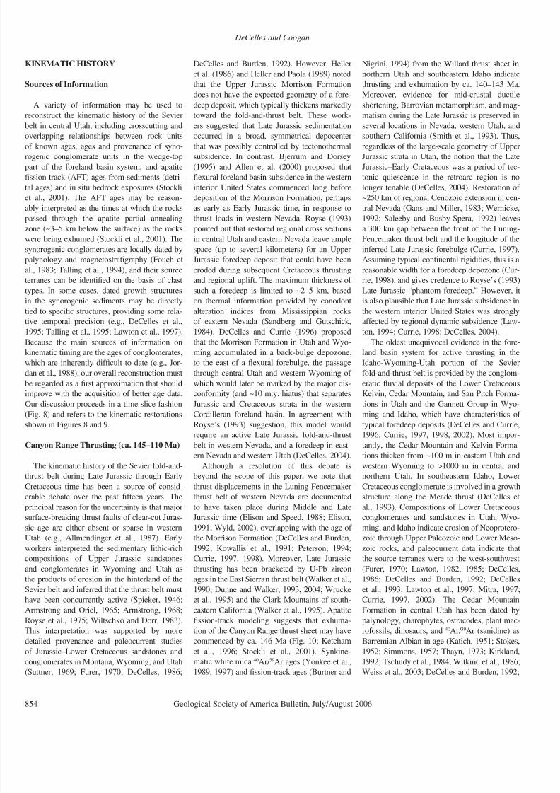
Canyon Range Thrust
The Canyon Range thrust sheet is exposed as
an isolated klippe in the Canyon Range (Chris-
tiansen, 1952; Holladay, 1983; Figs. 3 and 4).
However, Neoproterozoic and Lower Cam-
brian strata inferred to lie in the hanging wall
of the Canyon Range thrust are also exposedin the Cricket and Drum Mountains to the
southwest and west of the Sevier Desert basin
(Figs. 2 and 3; Allmendinger et al., 1983). In
the Canyon Range, the Canyon Range thrus
carries a 3.9-km-thick succession of Neoproterozoic and Cambrian strata. The rocks in the
footwall of the Canyon Range thrust are Neo
proterozoic to Devonian and are at least 3.5 km
thick (Fig. 5). In the Canyon Range, the Can
yon Range thrust is folded into a north-trend
ing synform such that two traces of the fault are
exposed (Figs. 4 and 5). The eastern trace dip
moderately westward (~40°W) and juxtapose
40°W-dipping quartzite of the Neoproterozoic
Pocatello Formation against 25°W-dipping
Devonian carbonate strata in the footwall. The
western trace of the fault in the southern part o
the range dips moderately eastward (40°), bu
becomes increasingly steep toward the northuntil it is overturned, dipping 40–50°W in the
northern part of the range (Mitra and Sussman
1997; Ismat and Mitra, 2001; Mitra and Ismat
Figure 4. Geological map of the central part of the Canyon Range, after Lawton et al. (1997) with minor modifications by the authors and Isma
and Mitra (2005). X–X′ marks the line of cross section shown in Figure 5. PVT(b)—hanging wall imbricate of the Pavant thrust sheet.
6000
4000
2000
0
-2000
-4000
-6000
-8000
8000
10000
-10000
Cp
Cu
p C p
pCc
pCi
pCm
Op-Sl
pCm-Ctp C m - C t
pCi
pCi
pCm-Ct
Ct
C-OPVT(a)
CRT
CRT
PXT
-1000
-2000
-3000
1000
3000
(m) (ft)
PVT(b)
P V T ( b )
D s - D c
No vertical exaggeration
Future SDD
PVT(c)
KTc
Qa
0 2 km
Projected basal
contact of KTc
Elevation
X X’
Figure 5. Cross section X–X′ through the central part of the Canyon Range. See Figure 4 for location of section line. Symbols are abbrevi
ated as follows: CRT—Canyon Range thrust; PVT(a)—main Pavant thrust; PVT(b) and PVT(c)—hanging wall imbricates of the Pavant
thrust sheet that are involved in the Canyon Range duplex; C-O—undivided Cambrian-Ordovician in footwall of Pavant thrust; Ds-Dc—
Devonian Simonson and Sevy, Guilmette, and Cove Fort Formations; Op-Sl—Ordovician Pogonip Group, Eureka Quartzite, Fish Haven
Dolomite, and Silurian Laketown Dolomite. Other symbols are listed in legend of Figure 4.

8/22/2019 DeCelles Servier Thrust
http://slidepdf.com/reader/full/decelles-servier-thrust 8/24
DeCelles and Coogan
848 Geological Society of America Bulletin, July/August 2006
2001). Along the western trace, east-dipping
(in the southern part of the range) to over-
turned, west-dipping (in the northern part of
the range) Pocatello strata in the hanging wall
are juxtaposed against steeply east-dipping to
overturned Cambrian and Ordovician strata
(Fig. 4). A stratigraphic separation diagram
(Fig. 6) shows that, in the tectonic transportdirection, the Canyon Range thrust juxtaposes
Neoproterozoic rocks that are cut at a low angle
to the fault in the hanging wall with rocks that
are cut at a moderate angle in the footwall—i.e.,
a configuration that indicates juxtaposition of a
low-angle hanging-wall ramp on a frontal foot-
wall ramp (Fig. 5). Along its northern exposed
portion, the western trace of the Canyon Range
thrust cuts down-section laterally toward the
north, indicating that a lateral ramp exists in
the footwall as well (Figs. 4 and 6).
To the west of the western trace of the Can-
yon Range thrust, the fault is inferred to lie in
the shallow subsurface along the western flank
of the Canyon Range (Mitra and Sussman,
1997; Mitra and Ismat, 2001). The evidence for
this interpretation is the presence of outcrops of
the Pocatello Formation, which have been dis-
placed downward to the west by a normal faultalong the western flank of the range. The Can-
yon Range thrust was folded into an antiform-
synform pair in the Canyon Range prior to dis-
ruption by erosion and normal faulting (Fig. 5;
Ismat and Mitra, 2005).
An important feature of the Canyon Range
thrust sheet is its close association with the
Canyon Range Conglomerate (Figs. 5 and 7;
Stolle, 1978). The conglomerate consists of
coarse alluvial fan, fluvial, and possibly shal-
low-marine lithofacies (DeCelles et al., 1995;
Lawton et al., 1997). The only published con-
straint on the age of the conglomerate is that it
contains quartzite clasts that yielded a mid-Cre-
taceous (96.8 ± 10.6 Ma) apatite fission-track
age (Stockli et al., 2001). This age is consistent
with unpublished Cenomanian-Turonian paly-
nological ages from outcrops higher in the sec-
tion (T. White, 2002, personal commun.). TheCanyon Range Conglomerate buries the Canyon
Range thrust, but contains growth structures that
indicate that it was deformed as it accumulated
by slip on minor bedding-plane detachments in
the hanging wall of the thrust (Fig. 7C). Con-
trary to previous interpretations (e.g., Stolle,
1978; Royse, 1993; DeCelles et al., 1995; Mitra
and Sussman, 1997; Schwans and Campion,
1997), the conglomerate is not cut by the Can-
yon Range thrust in outcrops along the eastern
flank of the range; rather, it overlaps the frontal
1
2
3
0km
CanyonRange
Conglomerate
P r o t e r o z o i c
C a m b r i a n
C r e t a c e o u s -
P a l e o c e n e ?
Hanging Wall Section(Canyon Range Thrust Sheet)
0 10 20 30 40
MutualFm.
Tintic Fm.
Limestone,undivided
Pioche Fm.
Inkom Fm.
Caddy CanyonFm.
4
Eastern trace,footwallEastern trace buried
Western trace, footwall
Western trace, hanging wall
Distance south (km)
Pocatello Fm.
1
2
0km
3
Mutual Fm.
Tintic Fm.
Limestone,undivided
Pioche Fm.
Pogonip Gr.
Eureka Quartzite, Fish Haven& Laketown Dolomites
Sevy & SimonsonFms.
Guilmette Fm.
Canyon RangeConglomerate
C a m b r i a n
Ordov.-
Silurian
D e v o n i a n
C r e t a c e o u s -
P a l e o c e n e ?
Footwall Section(Pavant Thrust Sheet)
Pro-teroz.
OakCreek
BlackrockLimestone
Lateral rampin footwall
Eastern trace,hanging wall
? ?
??
Eastern trace buried
3
1
2
Figure 6. North-south–oriented stratigraphic separation diagram for the Canyon Range thrust in the map area of Figure 4. Circled num-
bers highlight the following important aspects of the diagram: (1) Canyon Range thrust climbs ~250 m in the hanging-wall stratigraphy
from west to east across the range, indicating the presence of a low-angle hanging-wall ramp and corresponding hanging-wall cutoffs; (2) in
the southern part of the Canyon Range, the thrust climbs ~1 km in the footwall from west to east, indicating a relatively high-angle footwall
ramp, whereas farther north the thrust climbs ~2.5 km from west to east in the footwall; (3) from north to south, the thrust climbs ~1.5 km
in the footwall stratigraphy, indicating the presence of a major northward-dipping footwall lateral (or oblique) ramp.

8/22/2019 DeCelles Servier Thrust
http://slidepdf.com/reader/full/decelles-servier-thrust 9/24
Sevier fold-and-thrust belt
Geological Society of America Bulletin, July/August 2006 849
part of the thrust sheet in buttress unconformity
(Figs. 4 and 7C). The significance of the growth
structures in the Canyon Range Conglomerate
for the regional kinematic history of the Sevier
belt is discussed in a subsequent section.
On a regional scale, the geometry and dis-
placement for the Canyon Range thrust depend
on matching the hanging-wall geometry exposedin the Canyon Range with footwall cutoff loca-
tions interpreted beneath the Cricket Moun-
tains and the House Range along the COCORP
seismic line. Low-angle, Neoproterozoic-level
hanging-wall cutoffs are documented across
the Canyon Range thrust in the Canyon Range
(Fig. 6). Total thrust displacement therefore
depends on the location of equivalent footwall
cutoffs interpreted from the COCORP data. The
interpretation hinges on a series of continuous
high-amplitude reflections beneath the Cricket
Mountains and House Range that was recog-
nized by Allmendinger et al. (1983, 1986), Sharp
(1984), Planke and Smith (1991), and Royse(1993) as correlating, in part, to the Middle Cam-
brian carbonates and Lower Cambrian quartzite
sequence penetrated beneath the Canyon Range
thrust by the Cominco American well through
the Cricket Mountains block (Well #2 in Figs. 2
and 3). Published displacement estimates vary
from 40 to 70 km (Sharp, 1984; Royse, 1993),
to 116 km (Currie, 2002), to the >150 km of dis-
placement implied in the pre-extension recon-
struction of the House Range, Utah, and Snake
Range, Nevada, by Bartley and Wernicke (1984).
The variation in displacement estimates for the
Canyon Range thrust reflects the different inter-pretations of where the Canyon Range thrust
cuts down-section westward to Neoproterozoic
footwall levels from the Cambrian footwall level
of the Cominco well. The balanced and restored
cross section through the Cricket Mountains
and House Range in Figures 3 and 8 places
Neoproterozoic-level footwall cutoffs west of
the House Range, indicating a pre-extension
Canyon Range thrust displacement of ~107 km
at the Lower Cambrian level. This estimate is
based in part on the constant thickness of the
high-amplitude reflection package (“events C”
of Allmendinger et al., 1983) beneath the Can-
yon Range thrust sheet upon depth conversion.
The constant reflection interval is consistent with
a constant thickness of Cambrian through Neo-
proterozoic footwall strata that were penetrated
by the Cominco well beneath the Canyon Range
thrust. When combined with the surface out-
crop data and internal reflections for the Canyon
Range hanging wall, the resulting geometry for
the Canyon Range thrust is that of a hanging-
wall Neoproterozoic-level flat superimposed on
a Cambrian-level footwall flat beneath the entire
House Range (Fig. 3). This interpretation con-
strains the easternmost location of Neoprotero-
zoic footwall cutoffs for the Canyon Range thrust
as somewhere west of the House Range, with a
resulting Canyon Range thrust displacement of
more than 100 km (see also Currie, 2002). We
estimate ~117 km of total fold-and-thrust short-
ening during main-phase emplacement of the
Canyon Range sheet (Fig. 8B).
Pavant Thrust and Canyon Range
Culmination
The Pavant thrust is known from outcrops
in the Pavant Range that expose a major thrust
fault that places Lower Cambrian Tintic Forma-
tion quartzite on top of Jurassic sandstone, shale,
and carbonate (Fig. 2; Burchfiel and Hickcox,
1972; Villien and Kligfield, 1986). In the Pavant
Range, the thrust is tilted into a gentle (<15°)
eastward dip. The Tintic Formation is intensely
deformed at the micro- and mesoscale, with
numerous tight folds that indicate top-to-the-east sense of shear (Sprinkel and Baer, 1982).
However, the outcrop pattern and the mapped
shape of the fault indicate that it is nearly paral-
lel to the rocks above and below. The frontal tip
of the Pavant thrust is buried in the subsurface to
the east of the Pavant Range.
A second area of exposure of the Pavant
thrust sheet is in the Canyon Range, where
Pavant thrust hanging-wall strata crop out along
the southeastern and western flanks of the range.
In the western Canyon Range, an antiformal
duplex composed of repeated horses of Tin-
tic and Mutual Formation quartzite and InkomFormation shale forms a structural culmination
referred to as the Canyon Range culmination
(Fig. 5; DeCelles et al., 1995; Mitra and Suss-
man, 1997; Ismat and Mitra, 2001, 2005). The
growth of this duplex folded the overlying Can-
yon Range thrust sheet into an antiform (Fig. 5).
The upper thrust sheet in the duplex along the
line of the cross section consists of a complete
stratigraphic succession from the Inkom Forma-
tion to the Ordovician carbonate rocks (Fig. 5),
which we interpret to be a western exposure of
the Pavant thrust sheet. The duplex itself also
consists of horses of the Pavant sheet (Ismat and
Mitra, 2001; Mitra and Ismat, 2001). Farther
north of our cross-section line, Mitra and Suss-
man (1997) mapped a structurally higher horse
of Tintic Formation directly west of (structurally
beneath) the western trace of the Canyon Range
thrust (Fig. 4).
The regional geometry and displacement for
the Pavant thrust are constrained by minimum
limits on the separation between Paleozoic-
level hanging-wall and footwall cutoffs. Cam-
brian and Ordovician hanging-wall cutoffs are
exposed on the north wall of Kanosh Canyon in
the southern Pavant Range (Fig. 2; Hintze et al.
2003) and must lie directly east of the Devonian
rocks of the Pavant hanging wall in the eastern
Canyon Range (Figs. 3 and 4; Hintze and Davis
2003). The easternmost possible location of the
equivalent footwall cutoffs is beneath the west
ern edge of the Sevier Desert basin. Five wells
and extensive seismic profiles across the basindemonstrate that the Cenozoic fill is underlain
by a continuous sequence of Lower Paleozoic
strata (Planke and Smith, 1991). The structura
position of these strata is defined by their con
tinuous correlation to Cambrian and Ordovician
rocks drilled in the Placid Henley well (Wel
#7 in Figs. 2 and 3), which lie beneath Neopro-
terozoic and Cambrian quartzites exposed in
the Pavant hanging wall of the western Canyon
Range. Thus, the Lower Paleozoic rocks beneath
the Sevier Desert basin fill form the continuous
footwall of the Pavant thrust where the hanging
wall has been extensionally stripped from the
area of the Sevier Desert basin. These hanging-wall and footwall cutoff constraints yield
published estimates for Pavant thrust displace
ment that vary from 29 km from a cross section
across the Pavant Range and southern Sevie
Desert by Royse (1993), to up to 45 km from
a series of alternative balanced cross sections
through the Canyon Range and northern Sevie
Desert by Sharp (1984). Our balanced cross sec
tion (Fig. 3) and reconstruction (Fig. 8) result in
~42 km of Lower Cambrian–level displacemen
on the Pavant thrust and its hanging wall duplex
thrusts in the Canyon Range, with total fold
and-thrust shortening of ~48 km.
Pavant Thrust Footwall Imbricates
The Pavant thrust system also contains exten
sive footwall imbricates for which displacemen
has not been emphasized or quantified in pre
vious studies. The Pavant footwall imbricate
include two splays of the Red Ridge thrust in
the southernmost Pavant Range (Hintze et al.
2003). The main Red Ridge thrust trace place
Permian through Triassic strata over Jurassic
strata. Surface hanging-wall and footwall cut
offs limit east-west displacement across the Red
Ridge thrust to ~16 km. An unnamed hanging
wall imbricate of the Red Ridge thrust places
Mississippian and Pennsylvanian strata ove
Permian strata. East-west displacement acros
this thrust is a minimum of 18 km between the
preserved Mississippian footwall cutoff and the
eroded Mississippian hanging-wall rocks along
the frontal trace of the fault.
Correlation of the Pavant footwall imbrica
tion 70 km northward to the Canyon Range
(Fig. 3) is based on the similar structural posi
tion, stratigraphic level, and displacement fo

8/22/2019 DeCelles Servier Thrust
http://slidepdf.com/reader/full/decelles-servier-thrust 10/24
DeCelles and Coogan
850 Geological Society of America Bulletin, July/August 2006
imbricate thrusts, which have been interpreted
from proprietary seismic profiles across the
Canyon Range and tied to a well east of the
Canyon Range. The Placid Monroe well (Well
#10 in Figs. 2 and 3) penetrated four thrust
sheets of Triassic through Middle Jurassic strata
east of and structurally beneath Devonian-level
exposures of the Pavant thrust sheet. These
thrust faults are interpreted as footwall imbri-
cates of the Pavant thrust that may be correla-
tive to the Red Ridge thrust system to the south.
This Triassic- through Jurassic-level displace-
ment in the well is balanced westward by equiv-
alent Upper Paleozoic–level shortening inter-
preted from seismic-reflection data beneath the
Pavant thrust sheet of the Canyon Range. Cam-
brian-level thrust displacement, and total short-
ening for the Pavant footwall imbricate system,
is ~26 km in Figure 8, in which post-Eocene
extension is removed from the present-day bal-
anced cross section in Figure 3.
A
CRC
T i n
t i c F m
.T i n t i c
F m .
P i o c h e F
m .
CambrianLS & Sh
C a m b r i a
n L S & S h
T i n t i c
F m .
PiocheFm.
CRC
EastWest
I n k o m F m
.
M u t u a l F
m.
C a d d y
C a n y o
n F m.
CRC
CRC
Fool Creek Pk.
Tintic Fm.
East
CRCCanyonRange thrust
CanyonRange thrust
B
C
Figure 7. (A) Boulder-conglomerate lithofacies, dipping westward, in Canyon Range Conglomerate just below Fool Creek Peak. (B) Oblique
aerial photograph of the core of the Canyon Range synform between Dry Fork and Wildhorse Peak (see Fig. 4 for location). Note the tight
synclinal fold in the Paleozoic section, the overlapping angular unconformity at the base of the Canyon Range Conglomerate (CRC), and
the growth syncline in the CRC. LS—limestone; Sh—shale. Width of image is ~3 km. (C) Panoramic photograph of the north side of Oak
Creek Canyon, showing the western trace of the Canyon Range thrust (far left), the approximate location of the eastern, buried trace of the
thrust (lower right), the eastern limb of the Canyon Range synform, and overlapping, growth-folded Canyon Range Conglomerate (CRC).
Width of image is ~5 km.

8/22/2019 DeCelles Servier Thrust
http://slidepdf.com/reader/full/decelles-servier-thrust 11/24
Sevier fold-and-thrust belt
Geological Society of America Bulletin, July/August 2006 85
Paxton Thrust System
The Paxton thrust is the least described of the
four thrust systems in central Utah because it
does not crop out at the surface. However, the
fault is identified beneath the Pavant thrust on
the basis of published seismic and well data
across the southern Pavant Range (Royse, 1993).The Paleozoic- through Jurassic-level footwall
ramp of the Paxton thrust is clearly imaged in
published seismic data on the western side of
the southern Pavant Range near Fillmore, Utah
(“sub-Pavant thrust(?)” of Mitchell and McDon-
ald, 1987). The equivalent hanging-wall cutoffs
are located near the Placid #1 Paxton well on the
east side of the southern Pavant Range (Royse,
1993; south of the area shown in Fig. 2). The
Paxton well penetrated Cambrian rocks of the
Paxton hanging wall, faulted over footwall
Jurassic rocks at 4.3 km depth. From these con-
straints alone, Paxton displacement is at least
28 km beneath the southern Pavant Range. Aproprietary seismic line confirms the continuity
of these fault observations beneath the range.
Similar constraints bracket the basic geometry
of the Paxton thrust and its displacement along
the central Canyon Range transect, 70 km north
of the Pavant Range data. The footwall ramp zone
of the Paxton system is interpreted in the Placid
Henley well west of the Canyon Range (Well #7
in Figs. 2 and 3). The well penetrated a thrust
fault that places the base of the ~1.2-km-thick
Cambrian carbonate sequence over Ordovician
strata, with a smaller thrust in the Cambrian car-
bonate section near the bottom of the well. Dip-meter data indicate that the lowest thrust in the
well forms a gently west-dipping ramp relative
to the gently east-dipping footwall. The changes
in dip in hanging-wall rocks above the lowest
thrust indicate that the two thrusts encountered
in the well may form a small antiformal duplex,
an interpretation that is supported by the appar-
ent domal and internal lateral ramp geometries
of this thrusted section imaged on a published
seismic line that ties to the well (Mitchell and
McDonald, 1987). The position of these thrusts
beneath the Pavant hanging-wall rocks exposed
in the Canyon Range and their similar structural
position to the Paxton footwall ramp zone near
Fillmore, Utah, indicate that the Henley well
drilled the Lower Paleozoic footwall ramp of
the Paxton thrust. The interpreted duplex thrust
zone encountered in the well is consistent with
minor collapse of the footwall ramp, which is a
common structural motif in fold-and-thrust belts
(Boyer and Elliott, 1982).
The limit of the Paxton thrust system east
of the Canyon Range is interpreted from two
wells. The Placid WXC Barton well (Well #9 in
Figs. 2 and 3) penetrated a steeply dipping and
overturned Lower Triassic and Upper Paleo-
zoic section above a thrust fault 4.8 km below
the surface. Upper Triassic through Devonian
footwall strata dip ~15° to the west in what
is interpreted as the hanging wall of the Gun-
nison thrust. The Barton well therefore defines
the Upper Paleozoic hanging-wall cut-off of a
thrust sheet that is east of and structurally belowthe Pavant footwall imbricate zone drilled by the
Placid Monroe well (Well #10 in Fig. 3). This
thrust occupies an equivalent structural position
to the eastern edge of the Paxton thrust defined
by the Paxton well to the south. The large Paleo-
zoic-level displacement of the thrust in the Bar-
ton well is consistent with the amount of Trias-
sic- through Middle Jurassic–level shortening
near the Amoco Sevier Bridge well (Well #12
in Figs. 2 and 3) directly to the east. The Sevier
Bridge well penetrated the east limb of an anti-
form that is cored by multiple thrust sheets of
Triassic through Middle Jurassic strata. The
well is interpreted to have penetrated the uppertwo horses of a Triassic-Jurassic–level duplex.
The two underlying horses are interpreted from
the seismic geometry of the eastern limb of
the antiform and from the structural relief pen-
etrated in the Sevier Bridge well above equiva-
lent Jurassic strata in the Chevron USA Chriss
Canyon well to the east (Well #11 in Figs. 2 and
3). The balanced cross section indicates that the
duplex penetrated by the Sevier Bridge well
(the Paxton duplex) accommodated ~20 km of
thrust displacement at the Triassic–Lower Juras-
sic stratigraphic level, which is equivalent to the
Paleozoic-level thrust displacement required forthe Paxton thrust system between the footwall
ramp in the Henley well (Well #7) and the hang-
ing-wall cutoffs in the Barton well (Well #9).
Structural balancing of the Triassic through
Upper Cretaceous strata indicates that the Pax-
ton thrust contributed an early phase of slip to
a frontal imbricate and passive back-thrust sys-
tem, which developed as a triangle zone above
Middle Jurassic evaporites at the front of the
thrust wedge. The restoration (Fig. 8) indicates
that this frontal back-thrust system remained
intermittently active throughout the remainder
of Sevier belt shortening.
Gunnison Thrust System
The Gunnison thrust system has been docu-
mented in industry boreholes and seismic pro-
files (Standlee, 1982; Lawton, 1985; Villien
and Kligfield, 1986; Royse, 1993). The thrust
sheet is currently the focus of renewed drilling
and seismic acquisition near the site of the 2004
Covenant oil field discovery on the Gunnison
thrust sheet near Richfield, Utah (Stefanic,
2005). Along our transect, the Gunnison thrust
sheet consists of a single fault-bend anticline in
Cambrian through Middle Jurassic strata, with
displacement at Middle Jurassic through Creta
ceous levels accommodated by further growth
of the frontal passive back-thrust system
which was established during Paxton thrust
ing (Fig. 8). The frontal back thrust was par
tially reactivated by a normal fault that formsthe western margin of the Sanpete Valley, and
the antiformal structure associated with the
back thrust is referred to as the Sanpete Valley
antiform (Lawton et al., 1993). The Paleozoic
through Lower Jurassic footwall cutoffs for the
Gunnison thrust are assumed to underlie the
~15° west-dipping panel of Paleozoic strata a
the base of the Placid WXC Barton well (Wel
#9 in Figs. 2 and 3). The corresponding hang
ing-wall cutoffs are placed directly west o
the Chevron USA Chriss Canyon well (Wel
#11 in Figs. 2 and 3), which bottomed in flat
lying Lower Jurassic rocks of the seismically
defined Gunnison footwall. Displacement onthe Gunnison thrust is estimated at 8.7 km
after removal of the Neogene normal slip on
the interconnected Sanpete Valley back thrus
(Fig. 8). Total shortening, as measured by dis
placement of the rear of the thrust wedge, is
~9.7 km for the Gunnison thrust system. For
comparison, Royse (1993) delineated ~6.8 km
of displacement for the Gunnison thrust nea
Salina, Utah, which would increase if Neogene
extension were removed.
Sevier Culmination
The Sevier culmination, or Sevier arch
(Harris, 1959), is a broad antiformal struc
ture (Fig. 3) defined by the erosional pattern
of Paleozoic subcrop beneath the basal Ter
tiary unconformity in western Utah (Harris
1959; Hintze and Davis, 2003), and by broadly
arched seismic reflectors documented on the
COCORP profile at depths of 5–10 km (All
mendinger et al., 1983, 1986; Allmendinger
1992). Allmendinger et al. (1983) interpreted a
least one additional, gently westward-dipping
reflection in the middle crust as a major thrus
fault in the basement within the core of the
culmination, possibly associated with a broad
antiformal duplex. Restoration of ~47 km o
Cenozoic slip on the Sevier Desert detachmen
fault (Coogan and DeCelles, 1996) places the
Sevier culmination at a high structural leve
directly to the west of the Canyon Range a
the cessation of regional shortening (Fig. 8)
The Pavant, Paxton, and Gunnison thrusts are
inferred to root beneath the Sevier culmination
whereas the Canyon Range thrust is passively
folded above the arch (Fig. 3; Allmendinger e
al., 1986).
8/22/2019 DeCelles Servier Thrust
http://slidepdf.com/reader/full/decelles-servier-thrust 12/24
DeCelles and Coogan
852 Geological Society of America Bulletin, July/August 2006
C r e t a c e o u s P a l e o c e n e f o r e l a n d b a s i n d e p o s i t s
M i d d l e - u p p e r J u r a s s i c
T r i a s s i c - m i d d l e J u r a s s i c
U p p e r P a l e o z o i c
L o w e r P a l e o z o i c
P r e c a m b r i a n - l o w e r C a m b r i a n
P r e c a m b r i a n b a s e m e n t
C R T
P V T
3 0
4 0
2 0 0 1
0
S L
C R T
P V T
A x h a n d l e W T
b a s i n
S e
v i e r
C u
l m i n
a t i o
n
C a
n y o
n R a
n g e
C u
l m i n
a t i
o n
G T
3 0
4 0
2 0 0 1
0
S L
1 6 0
1 4 0
1 2 0
1 0 0
1 8 0
6 0
4 0
2 0
8 0
2 4 0
2 2 0
2 0 0
0 k m
P V T
P V T
D U
P L E X
3 0
4 0
2 0 0 1
0
S L
m i d d l e I n d i a n o l a G r
u p p e r I n d i a n o l a G r .
N o r t h H o r n F m .
C R T
P X
T
F U T
U R E
P X T
F U T
U R E
G T
0 k m
1 6 0
1 4 0
1 2 0
1 0 0
1 8 0
6 0
4 0
2 0
8 0
2 6 0
2 4 0
2 2 0
2 0 0
2 8
0
3 2 0
3 0 0
3 4 0
M a x i m u m S
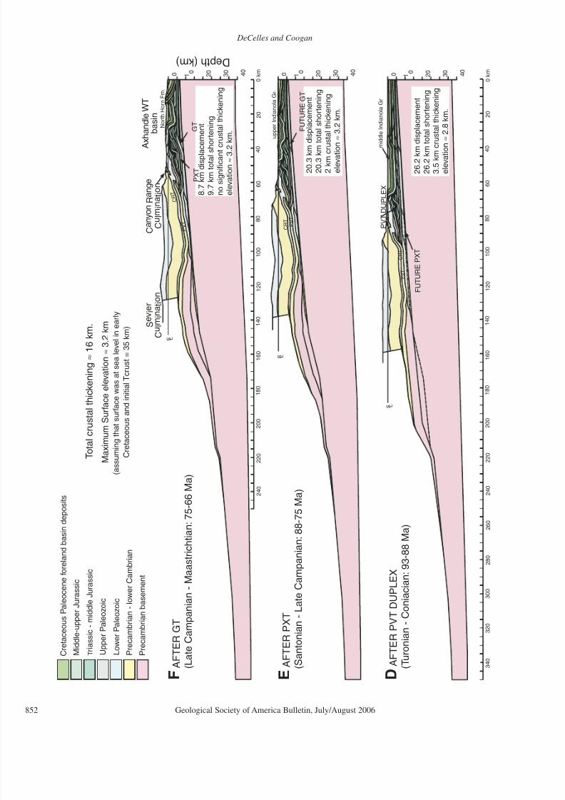
u r f a c e e l e v a t i o n ≈ 3 . 2
k m
( a s s u m i n g t h a t s
u r f a c e w a s a t s e a l e v e l i n e a r l y
C r e t a c e o u s
a n d i n i t i a l T c r u s t = 3 5 k m )
8 . 7 k m d i s p l a c e m
e n t
9 . 7 k m t o t a l s h o r
t e n i n g
n o s i g n i f i c a n t c r u
s t a l t h i c k e n i n g
e l e v a t i o n ≈ 3 . 2 k m .
2 0 . 3 k m d i s p l a c e m e n t
2 0 . 3 k m t o
t a l s h o r t e n i n g
2 k m c r u s t a l t h i c k e n i n g
e l e v a t i o n ≈ 3 . 2 k m .
F A F T E R G T
( L a t e C a m p a n i a n - M a a s t r i c h t i a n : 7 5 - 6 6 M a )
E A F T E R P X T
( S a n t o n i a n - L a t e C a m p a
n i a n : 8 8 - 7 5 M a )
2 6 . 2 k m d i s p l a c e m e n t
2 6 . 2 k m t o
t a l s h o r t e n i n g
3 . 5 k m c r u
s t a l t h i c k e n i n g
e l e v a t i o n ≈ 2 . 8 k m .
D A
F T E R P V T D U P L E X
( T u r o n i a n - C o n i a c i a n : 9 3 - 8 8 M a )
T o t a l c r u s
t a l t h i c k e n i n g ≈ 1
6 k m .
D e p t h ( k m )

8/22/2019 DeCelles Servier Thrust
http://slidepdf.com/reader/full/decelles-servier-thrust 13/24
Sevier fold-and-thrust belt
Geological Society of America Bulletin, July/August 2006 853
3 0
4 0
2 0 0 1
0
0 k m
1 6 0
1 4 0
1
2 0
1 0 0
1 8 0
6 0
4
0
2 0
8 0
2 6 0
2 4 0
2 2 0
2 0 0
3 0 0
2 8 0
C R T
P V T
3 0
4 0
2 0
0 1 0
P V T
F U T U R E
P V T
D U P L
E X
S h o r e l i n e
F u
t u r e
P V T
C R T
0 k m
1 6 0
1 4 0
1
2 0
1 0 0
1 8 0
6 0
4
0
2 0
8 0
2 6 0
2 4 0
2 2 0
2 0 0
3 0 0
2 8 0
3 0
4 0
2 0
0 1 0
S L
S L
C e d a r M o u n t a i n F m .
l o w e r I n d i a n o l a G r .
c r t 1
c r t 2
c r t 3 - 5
p v t 2 p
v t 3
p v t 4 , 5
c r t 2 - 5
F
U T
U R E
C R
T S L
3 2 0
3 4 0
C A
F T E R P V T
( M i d d l e A l b i a n - C e n o m a n i a n : 1 1 0 - 9 3 M a )
B A
F T E R C R T
( A p t i a n - E a r l y A l b i a n ? : > 1 1 0 M a )
1 0 6 . 8 k
m d i s p l a c e m e n t
1 1 6 . 7 k
m t o t a l s h o r t e n i n g
8 . 5 k m
c r u s t a l t h i c k e n i n g
Δ e
l e v a
t i o n ≈
1 . 5 7 k m .
A B
E F O R E C R T
4 2 . 4 k m d i s p l a c e m e n t
4 7 . 6 k m t o t a l s h o r t e n i n g
2 k m c
r u s t a l t h i c k e n i n g
e l e v a t i o n ≈
2 . 2 k m .
A p p r o x i m a t e w e s t e r n
l i m i t o f l a t e
J u r a s s i c b a c k - b u l g e d e p o s i t s
F i g u r e 8 ( o n t h
i s a n d p r e v i o u s p a g e
) . B a l a n c e d , i n c r e m e n t a l r e t r o d e f o r m a t i o n o f t h e c e n t r a l U t a h s e g m e n t o f t h e S e v i e r t h r u s t b e l t , b a s e d o n i n i t i a l d e f o r m e d s t a t e ( w i t h C e n o -
z o i c e x t e n s i o n r e s t o r e d ) o f c r o s s s e
c t i o n s h o w n i n F i g u r e 3 . I n p a n e l A , t h e d o t t e d l i n e s r e p r e s e n t e r o s i o n s u r f a c e s i n t h e C a n y o n R a n g e ( C R T ) a n d P a v a
n t ( P V T ) t h r u s t s h e e t s
t h r o u g h t i m e . P X T — P a x t o n t h r u s t ; G T — G u n n i s o n t h r u s t ; S D D — S e v i e r D e s e r t d e t a c h m e n t .
8/22/2019 DeCelles Servier Thrust
http://slidepdf.com/reader/full/decelles-servier-thrust 14/24
DeCelles and Coogan
854 Geological Society of America Bulletin, July/August 2006
KINEMATIC HISTORY
Sources of Information
A variety of information may be used to
reconstruct the kinematic history of the Sevier
belt in central Utah, including crosscutting and
overlapping relationships between rock unitsof known ages, ages and provenance of syno-
rogenic conglomerate units in the wedge-top
part of the foreland basin system, and apatite
fission-track (AFT) ages from sediments (detri-
tal ages) and in situ bedrock exposures (Stockli
et al., 2001). The AFT ages may be reason-
ably interpreted as the times at which the rocks
passed through the apatite partial annealing
zone (~3–5 km below the surface) as the rocks
were being exhumed (Stockli et al., 2001). The
synorogenic conglomerates are locally dated by
palynology and magnetostratigraphy (Fouch et
al., 1983; Talling et al., 1994), and their source
terranes can be identified on the basis of clasttypes. In some cases, dated growth structures
in the synorogenic sediments may be directly
tied to specific structures, providing some rela-
tive temporal precision (e.g., DeCelles et al.,
1995; Talling et al., 1995; Lawton et al., 1997).
Because the main sources of information on
kinematic timing are the ages of conglomerates,
which are inherently difficult to date (e.g., Jor-
dan et al., 1988), our overall reconstruction must
be regarded as a first approximation that should
improve with the acquisition of better age data.
Our discussion proceeds in a time slice fashion
(Fig. 8) and refers to the kinematic restorationsshown in Figures 8 and 9.
Canyon Range Thrusting (ca. 145–110 Ma)
The kinematic history of the Sevier fold-and-
thrust belt during Late Jurassic through Early
Cretaceous time has been a source of consid-
erable debate over the past fifteen years. The
principal reason for the uncertainty is that major
surface-breaking thrust faults of clear-cut Juras-
sic age are either absent or sparse in western
Utah (e.g., Allmendinger et al., 1987). Early
workers interpreted the sedimentary lithic-rich
compositions of Upper Jurassic sandstones
and conglomerates in Wyoming and Utah as
the products of erosion in the hinterland of the
Sevier belt and inferred that the thrust belt must
have been concurrently active (Spieker, 1946;
Armstrong and Oriel, 1965; Armstrong, 1968;
Royse et al., 1975; Wiltschko and Dorr, 1983).
This interpretation was supported by more
detailed provenance and paleocurrent studies
of Jurassic–Lower Cretaceous sandstones and
conglomerates in Montana, Wyoming, and Utah
(Suttner, 1969; Furer, 1970; DeCelles, 1986;
DeCelles and Burden, 1992). However, Heller
et al. (1986) and Heller and Paola (1989) noted
that the Upper Jurassic Morrison Formation
does not have the expected geometry of a fore-
deep deposit, which typically thickens markedly
toward the fold-and-thrust belt. These work-
ers suggested that Late Jurassic sedimentation
occurred in a broad, symmetrical depocenterthat was possibly controlled by tectonothermal
subsidence. In contrast, Bjerrum and Dorsey
(1995) and Allen et al. (2000) proposed that
flexural foreland basin subsidence in the western
interior United States commenced long before
deposition of the Morrison Formation, perhaps
as early as Early Jurassic time, in response to
thrust loads in western Nevada. Royse (1993)
pointed out that restored regional cross sections
in central Utah and eastern Nevada leave ample
space (up to several kilometers) for an Upper
Jurassic foredeep deposit that could have been
eroded during subsequent Cretaceous thrusting
and regional uplift. The maximum thickness of such a foredeep is limited to ~2–5 km, based
on thermal information provided by conodont
alteration indices from Mississippian rocks
of eastern Nevada (Sandberg and Gutschick,
1984). DeCelles and Currie (1996) proposed
that the Morrison Formation in Utah and Wyo-
ming accumulated in a back-bulge depozone,
to the east of a flexural forebulge, the passage
through central Utah and western Wyoming of
which would later be marked by the major dis-
conformity (and ~10 m.y. hiatus) that separates
Jurassic and Cretaceous strata in the western
Cordilleran foreland basin. In agreement withRoyse’s (1993) suggestion, this model would
require an active Late Jurassic fold-and-thrust
belt in western Nevada, and a foredeep in east-
ern Nevada and western Utah (DeCelles, 2004).
Although a resolution of this debate is
beyond the scope of this paper, we note that
thrust displacements in the Luning-Fencemaker
thrust belt of western Nevada are documented
to have taken place during Middle and Late
Jurassic time (Elison and Speed, 1988; Elison,
1991; Wyld, 2002), overlapping with the age of
the Morrison Formation (DeCelles and Burden,
1992; Kowallis et al., 1991; Peterson, 1994;
Currie, 1997, 1998). Moreover, Late Jurassic
thrusting has been bracketed by U-Pb zircon
ages in the East Sierran thrust belt (Walker et al.,
1990; Dunne and Walker, 1993, 2004; Wrucke
et al., 1995) and the Clark Mountains of south-
eastern California (Walker et al., 1995). Apatite
fission-track modeling suggests that exhuma-
tion of the Canyon Range thrust sheet may have
commenced by ca. 146 Ma (Fig. 10; Ketcham
et al., 1996; Stockli et al., 2001). Synkine-
matic white mica 40Ar/ 39Ar ages (Yonkee et al.,
1989, 1997) and fission-track ages (Burtner and
Nigrini, 1994) from the Willard thrust sheet in
northern Utah and southeastern Idaho indicate
thrusting and exhumation by ca. 140–143 Ma.
Moreover, evidence for mid-crustal ductile
shortening, Barrovian metamorphism, and mag-
matism during the Late Jurassic is preserved in
several locations in Nevada, western Utah, and
southern California (Smith et al., 1993). Thus,regardless of the large-scale geometry of Upper
Jurassic strata in Utah, the notion that the Late
Jurassic–Early Cretaceous was a period of tec-
tonic quiescence in the retroarc region is no
longer tenable (DeCelles, 2004). Restoration of
~250 km of regional Cenozoic extension in cen-
tral Nevada (Gans and Miller, 1983; Wernicke,
1992; Saleeby and Busby-Spera, 1992) leaves
a 300 km gap between the front of the Luning-
Fencemaker thrust belt and the longitude of the
inferred Late Jurassic forebulge (Currie, 1997).
Assuming typical continental rigidities, this is a
reasonable width for a foredeep depozone (Cur-
rie, 1998), and gives credence to Royse’s (1993)Late Jurassic “phantom foredeep.” However, it
is also plausible that Late Jurassic subsidence in
the western interior United States was strongly
affected by regional dynamic subsidence (Law-
ton, 1994; Currie, 1998; DeCelles, 2004).
The oldest unequivocal evidence in the fore-
land basin system for active thrusting in the
Idaho-Wyoming-Utah portion of the Sevier
fold-and-thrust belt is provided by the conglom-
eratic fluvial deposits of the Lower Cretaceous
Kelvin, Cedar Mountain, and San Pitch Forma-
tions in Utah and the Gannett Group in Wyo-
ming and Idaho, which have characteristics of typical foredeep deposits (DeCelles and Currie,
1996; Currie, 1997, 1998, 2002). Most impor-
tantly, the Cedar Mountain and Kelvin Forma-
tions thicken from ~100 m in eastern Utah and
western Wyoming to >1000 m in central and
northern Utah. In southeastern Idaho, Lower
Cretaceous conglomerate is involved in a growth
structure along the Meade thrust (DeCelles et
al., 1993). Compositions of Lower Cretaceous
conglomerates and sandstones in Utah, Wyo-
ming, and Idaho indicate erosion of Neoprotero-
zoic through Upper Paleozoic and Lower Meso-
zoic rocks, and paleocurrent data indicate that
the source terranes were to the west-southwest
(Furer, 1970; Lawton, 1982, 1985; DeCelles,
1986; DeCelles and Burden, 1992; DeCelles
et al., 1993; Lawton et al., 1997; Mitra, 1997;
Currie, 1997, 2002). The Cedar Mountain
Formation in central Utah has been dated by
palynology, charophytes, ostracodes, plant mac-
rofossils, dinosaurs, and 40Ar/ 39Ar (sanidine) as
Barremian-Albian in age (Katich, 1951; Stokes,
1952; Simmons, 1957; Thayn, 1973; Kirkland,
1992; Tschudy et al., 1984; Witkind et al., 1986;
Weiss et al., 2003; DeCelles and Burden, 1992;

8/22/2019 DeCelles Servier Thrust
http://slidepdf.com/reader/full/decelles-servier-thrust 15/24
Sevier fold-and-thrust belt
Geological Society of America Bulletin, July/August 2006 855
0
-4
O-S
Canyon RangeConglomerate
C R T
O-SD
C R T
O-SD
CRTO-S
O-S
Total shor tening~ 14 km
5 km0
5
PVT(a)
PVT(b)
PVT(a)
PVT(a)
PVT(b&c)
PVT(a)
PVT(b&c)
PVT(a)
D
CRT D
DCRT
Ordovician-Silurian
D
O-S
Devonian
Cambrian limestone & shaleundivided
Cambrian Pioche Fm.
Neoproterozoic-lower Cambrian
Canyon Range Conglomerate
pCs
Cu
Cp
pCspCs
pCs
Cu
CppCs
pCs
Cu
pCs
Cu
Cp
pCs
pCs
pCs
Cu
Cp
pCs
Cu
Cp
pCs
pCs
Cp
pCs
Cu
A
B
C
D
E
P V T ( b
)
PVT(c)
P V T ( b
)
PVT(c)
P V T( b )
PVT(b&c)
pCsPVT(c)
Canyon RangeCulmination
Canyon RangeConglomerate
Canyon RangeConglomerate
D e p
t h ( k m )
Figure 9. Balanced, incremental retrodeformation of cross-section X–X′ through the Canyon Range (shown in Figure 5). The initial state o
the cross section (lower panel) represents the structure immediately after displacement on the main Pavant thrust (PVT[a]). Faults labeled
PVT(b) and PVT(c) are hanging-wall imbricate splays that facilitated construction of the Canyon Range duplex in stages B–E. CRT—Can
yon Range thrust. Canyon Range Conglomerate is projected into plane of cross section for purpose of illustrating general geometric rela
tionships. Dashed upper surface of the antiformal culmination is an approximate erosional surface through time.

8/22/2019 DeCelles Servier Thrust
http://slidepdf.com/reader/full/decelles-servier-thrust 16/24
DeCelles and Coogan
856 Geological Society of America Bulletin, July/August 2006
Lawton et al., 1997; Cifelli et al., 1997; Sprin-
kel et al., 1999). Taken together, the provenance,
paleocurrent, and geochronologic data from the
Cedar Mountain Formation (and its equivalents)
and the thermochronologic data from the Can-
yon Range thrust sheet (Ketcham et al., 1996)
suggest that Upper Jurassic–Lower Cretaceous
(ca. 145–110 Ma) foreland basin deposits datethe initial displacement on the Canyon Range
thrust (Lawton, 1985; Schwans, 1988; DeCelles
et al., 1995; Currie, 2002).
In central Utah, no proximal alluvial fan
facies are preserved in Lower Cretaceous strata
(e.g., Yingling and Heller, 1992; Lawton et al.,
1997; Currie, 1997, 2002). The westernmost
outcrops of Lower Cretaceous strata are in the
antiformal Paxton duplex along the western
flank of the San Pitch Mountains, the palinspas-
tic (pre-Neogene extension) location of whichlay 60–70 km east of the likely topographic
front associated with the Canyon Range thrust
(Fig. 8B). Currie’s (2002) reconstruction of the
Early Cretaceous foreland basin system in cen-
tral Utah indicates that the crest of the forebulge
was located ~120–140 km farther east. Thus,
the Early Cretaceous foredeep was on the order
of 200 km wide in this region.
Pavant Thrusting and Duplexing (Late
Albian–Coniacian, ca. 110–86 Ma)
The next major phase of thrusting took place
along the Pavant thrust and involved a complex
Paleocene
AGE
Campanian
Santonian
TuronianConiacian
Maastrichtian
North
HornFm.
N E O C O
M I A N
Aptian
Albian
Cenomanian
EASTWEST
FORMATION
Canyon Rangethrust
Pavantthrust
Paxtonthrust
Internalduplexing ofPVT sheetand growthof CRsyncline
Gunnison
thrust
C a n y o n R a n g e C o n g l o m e r a t e
60WEST EAST
S e v i e r C u l m i n a t i o n
MAJOR THRUSTING EVENTS
Paxtonduplex
I n d i a n o l a G r .
SanPitchFm.
CedarMtn.Fm.
MorrisonFm.
Barremian
Hauterivian
Valanginian
Berriasian
Tithonian
Tertiary
C r e t a c e o u s
Jurassic
100
110
120
130
90
80
70
140
150
PERIOD
ReddickCyn.
TroughSpring
Pavantduplex
??
??
??
P
AFT
P
Flagstaff Fm.
(Axhandle basin)
P
AFT
Palynological age
Detrital apatitefission track age& error range
Frontaltrianglezone
?
?
A g e
( M a )
Figure 10. Chart showing the timing of major thrusting events and growth of the Sevier culmination in the central Utah segment of the
Sevier fold-and-thrust belt. CR—Canyon Range; PVT—Pavant thrust.

8/22/2019 DeCelles Servier Thrust
http://slidepdf.com/reader/full/decelles-servier-thrust 17/24
Sevier fold-and-thrust belt
Geological Society of America Bulletin, July/August 2006 857
series of in-sequence and out-of-sequence events
(Figs. 8, 9, and 10). The total minimum slip on
the Pavant system is ~68.6 km, which includes
42.4 km of initial slip on the main thrust and
subsequent internal shortening during growth of
the Canyon Range duplex, followed by 26.2 km
of slip accommodated on Pavant imbricates and
within the Pavant duplex (Figs. 8 and 9). Thelate Albian–Cenomanian age of initial Pavant
sheet emplacement is based on the compositions
of conglomerates in the palynologically dated
late Albian–Cenomanian San Pitch Formation
(lower Indianola Group) in the western San Pitch
Mountains (DeCelles et al., 1995; Lawton et al.,
1997; Sprinkel et al., 1999). In addition, growth
structures in the Canyon Range Conglomerate
provide constraints on the timing of thrusting
in the Canyon Range duplex (DeCelles et al.,
1995; Mitra and Sussman, 1997).
As mentioned already, the Canyon Range
thrust sheet was folded into an anticline-syn-
cline pair in the Canyon Range. Approxi-mately 10° of the westward dip of the eastern
limb of the syncline probably developed dur-
ing emplacement of the Canyon Range thrust
along its frontal footwall ramp (Fig. 9A). The
anticline developed when the Canyon Range
duplex grew beneath the Canyon Range thrust
sheet (Mitra and Sussman, 1997; Mitra, 1997;
Ismat and Mitra, 2005). Progressive eastward
tilting of the shared fold limb (Fig. 9C–E)
caused a space problem in the core of the syn-
cline that was relieved by bedding-parallel slip
along shale zones in the Pocatello and Inkom
Formations. Growth structures in the CanyonRange Conglomerate developed in associa-
tion with these minor detachments (Fig. 7B–C;
DeCelles et al., 1995; Mitra and Sussman,
1997). Minor (several hundred meters) slip
along the base of the Caddy Canyon Formation
quartzite (Fig. 7C) actually cut the lower part
of the Canyon Range Conglomerate; this thrust
relationship previously has been mistaken for
reactivation of the Canyon Range thrust, but
recent mapping shows that the real Canyon
Range thrust is buried by the conglomerate
north of Little Oak Creek Canyon (Fig. 4) and
was not reactivated. The Canyon Range Con-
glomerate consists of coarse-grained, proximal
alluvial fan facies (Fig. 7A) that alternate in ver-
tical succession with more distal, finer-grained,
better-organized fluvial facies. The alluvial fan
conglomerates were derived mainly from the
western limb of the Canyon Range syncline,
whereas the fluvial conglomerates were derived
from more distal sources to the west of the Can-
yon Range on the crest of the Sevier culmina-
tion, as well as from the rocks of the Canyon
Range syncline (DeCelles et al., 1995; Lawton
et al., 1997).
In the structural model (Fig. 9), the Canyon
Range duplex is composed of Neoproterozoic-
Ordovician quartzite and carbonate rocks of the
Pavant thrust sheet (Mitra and Sussman, 1997).
The duplex formed as thrusts broke up the inter-
nal part of the Pavant thrust sheet after it had
been emplaced at a high structural level by slip
on the main Pavant thrust (PVT[a] in Fig. 9).Slip on thrusts within the duplex could have
been fed updip (eastward) into a detachment in
the lower part of the Paleozoic succession (e.g.,
in the Pioche [or Ophir] Formation, which is
composed mainly of shale), now buried along
the eastern flank of the Canyon Range. Alter-
natively, thrust faults in the duplex could have
ramped upsection and connected with the Can-
yon Range thrust, forming a connecting splay
duplex (Mitra and Sussman, 1997; Mitra and
Ismat, 2001). For the connecting splay model to
work as explained by Mitra and Sussman (1997),
some slip on duplex faults must have been
transferred into the hanging wall of the CanyonRange thrust. In part, this interpretation is based
on a branch point between the Canyon Range
thrust and a structurally lower splay mapped
by Mitra and Sussman (1997) ~4.5 km north
of cross-section X–X′ (Fig. 4; near 39°30′N,
112°15′W). However, the fact that the eastern
trace of the Canyon Range thrust does not cut
the Canyon Range Conglomerate requires that
slip transferred from the duplex must have been
accommodated by internal folding and minor
bedding-parallel detachment faults, which are
common in the eastern limb of the Canyon
Range syncline. Mitra and Sussman (1997) andIsmat and Mitra (2005) showed that fault-propa-
gation folding and cataclastic flow in a connect-
ing splay duplex may have accommodated most
of the duplex shortening, limiting the need to
transfer large amounts of slip into the overlying
thrust sheet. In our structural model, the Canyon
Range duplex is depicted as a simple antiformal
duplex with a single horse of Neoproterozoic
rocks in its core, because along the line of cross-
section X–X′ no connecting splays can be dem-
onstrated in the surface geology. It is conceiv-
able, however, that the faults within the duplex
are connected to the Canyon Range thrust sheet
by a buried connecting splay (Mitra and Ismat,
2001). It is also possible that the Canyon Range
duplex is a hybrid, consisting of a connecting
splay duplex in the northern part of the Canyon
Range and a conventional antiformal stack in
the central part of the range.
Although the Canyon Range duplex could
have developed before the frontal portion of
the Pavant sheet was emplaced (i.e., as a fore-
landward propagating series of thrusts), our pre-
ferred model satisfies the requirement that the
duplex must have developed at a shallow level
(<5 km below the surface; Fig. 9B–E), whereas
the alternative model does not. The alternative
model would have the duplex form at a depth
of ~10 km and then be transported to a highe
structural level during development of the fronta
part of the Pavant thrust system. Three lines o
information indicate that the duplex developed
near the surface. First, the intimate associationof duplex growth, folding of the west limb o
the Canyon Range syncline, and deposition and
deformation of the Canyon Range Conglomer
ate demands that the duplex formed close to
the surface (e.g., Mitra and Sussman, 1997)
Second, microstructural data presented by Suss
man and Mitra (1995), Sussman (1995), Isma
and Mitra (2001, 2005), and Mitra and Isma
(2001) show that deformation in the quartzite
of the duplex and in the Canyon Range thrus
sheet occurred in the elastico-frictional regime
at depths not greater than ~5 km. Third, as noted
previously, the Canyon Range Conglomerate
which was partly derived from the western limbof the Canyon Range syncline as it was uplifted
during duplex growth, rests upon Cambrian
strata in the hanging wall of the Canyon Range
thrust and upon Devonian strata in the footwal
of the thrust. Thus, a substantial amount of ero
sion (several kilometers) must have occurred
before deposition of the conglomerate, which in
turn suggests that duplexing occurred after the
rocks in the footwall of the Canyon Range thrus
had been structurally elevated and exposed a
the surface.
Palynological data and detrital apatite fission
track ages from the Canyon Range Conglomerate constrain the age of the conglomerate and
the growth of the Canyon Range duplex. Growth
strata in the Canyon Range Conglomerate are
mainly in the lower to middle part of the unit
A fission-track age of ca. 97 Ma (Stockli et al.
2001) from a quartzite clast in the lower-middle
part of the conglomerate indicates that this par
of the conglomerate cannot be older than tha
age. Palynological data collected by T. White
(2002, personal commun.) suggest a Cenoma
nian-Turonian age for beds in the middle part o
the conglomerate. These data are consistent with
age data from the San Pitch Formation, which
indicate an Albian-Cenomanian age, and sup
port the partial correlation of these two units as
proposed by Lawton et al. (1997; Fig. 10). The
minimum age of the Canyon Range Conglomer
ate remains uncertain; it could extend into the
early Paleocene (Lawton et al., 1997). However
the younger part of the conglomerate appar
ently was not affected by growth of the Canyon
Range syncline and other structures related to
Pavant thrusting (Lawton et al., 1997).
The preceding reconstruction of tectonic
events in the Canyon Range helps to explain the

8/22/2019 DeCelles Servier Thrust
http://slidepdf.com/reader/full/decelles-servier-thrust 18/24
DeCelles and Coogan
858 Geological Society of America Bulletin, July/August 2006
compositions of conglomerates in the San Pitch
Formation (Sprinkel et al., 1992; DeCelles et
al., 1995). These conglomerates contain clasts
of Neoproterozoic quartzite, Paleozoic chert,
carbonate, and quartzite, and small amounts of
quartzose sandstone with frosted, eolian grains.
The Neoproterozoic quartzites could have been
derived only from the Canyon Range thrustsheet, whereas the Paleozoic clasts could have
been derived from both the Canyon Range and
Pavant sheets. The eolian sand grains may reflect
erosion of Jurassic strata from a structure asso-
ciated with the frontal tip of the Pavant thrust
(Fig. 8C). The Albian-Cenomanian age of the
San Pitch Formation and the likely Cenomanian-
Turonian age of the Canyon Range Conglomer-
ate in the Canyon Range syncline (DeCelles et
al., 1995; Stockli et al., 2001) suggest that the
main phase of Pavant thrusting was Albian,
whereas the internal breakup and duplexing of
the Pavant sheet took place during Cenomanian-
Turonian time (Fig. 10).
Paxton Thrusting (Santonian–Early
Campanian? ca. 86–75 Ma)
The Paxton thrust sheet is defined entirely
from subsurface data with only nonresistant
Jurassic and Cretaceous rocks exposed in broad
hanging-wall folds above the Paxton duplex and
along the frontal triangle zone. The age of the
Paxton thrust is therefore primarily constrained
by a profound angular unconformity at the base
of the North Horn Formation, which defines the
uplifted western and eastern margins of the Cam-panian-Paleocene Axhandle wedge-top basin in
the San Pitch Mountains (Fig. 2; Lawton et al.,
1993; Talling et al., 1995). The unconformity
overlies the eastern limb of the Paxton duplex
on the western side of the San Pitch Mountains,
where it separates ~25–45° east-dipping beds
of the late Albian–early Campanian Indianola
Group from ~5° east-dipping Maastrichtian
strata of the North Horn Formation (Mattox,
1987; Weiss et al., 2003). Thus, the principal
growth of the Paxton duplex is inferred to have
been complete before Maastrichtian time in this
area, although a last increment of uplift is attrib-
uted to slip on the underlying Gunnison thrust
after cessation of Paxton slip (Fig. 8E–F). On
the eastern side of the San Pitch Mountains, a
phase of early slip on the frontal triangle zone
is recorded by the ~90° angular unconformity
that separates overturned, east-dipping Albian-
Turonian beds of the Indianola Group from
steeply to moderately west-dipping late Campa-
nian strata of the North Horn Formation (Law-
ton and Weiss, 1999). Thus, an early phase of
triangle zone deformation is pre–late Campan-
ian in age (Fig. 8D). Triangle zone thrust dis-
placement that is rooted to the Paxton thrust is
necessary to balance Middle Jurassic– through
Cretaceous-level shortening with deeper-level
shortening of the main Paxton thrust sheet
and duplex (Fig. 8E). The broad synchronicity
between uplift above the Paxton duplex and the
frontal triangle zone corroborates the structural
correlation of early triangle zone displacementto the Paxton thrust system.
Because of the shallow erosion levels of the
Paxton thrust sheet and the continued expo-
sure of resistant lithologies from the previously
emplaced Canyon Range and Pavant thrust
sheets, the Paxton sheet provided no diagnos-
tic unroofing signal in the foreland basin. The
main effect of Paxton thrusting on the unroof-
ing history of the proximal foreland basin sys-
tem was erosion of Jurassic fine-grained rocks
during Paxton duplexing (Figs. 8E and 10). The
nonresistant character of the Jurassic rocks may
account for the influx of fine-grained facies doc-
umented in the San Pitch Mountains during San-tonian time (Lawton, 1985; Lawton et al., 1993).
This was also a time of marine transgression in
the foreland basin, and deltaic and marginal-
marine environments developed in the wedge-
top depozone of the foreland basin system.
Gunnison Thrusting (Late Campanian–
Maastrichtian, ca. 75–65 Ma)
Displacement on the Gunnison thrust system
transported the previously formed Paxton duplex
up and over the Gunnison ramp from Cambrian
to Middle Jurassic levels, and displacement athigher levels was accommodated by the frontal
back-thrust system and Sanpete Valley antiform
along the eastern side of the Axhandle wedge-
top basin (Figs. 8F and 10). The timing of
thrusting in the Gunnison thrust system is rela-
tively well dated at middle-to-late Campanian
through Paleocene time because of the coeval
development of the Axhandle wedge-top basin
(Lawton and Trexler, 1991; Lawton et al., 1993;
Talling et al., 1994, 1995). This basin accumu-
lated up to 1.1 km of conglomerate, sandstone,
mudstone, and limestone between the Paxton
duplex and the frontal Sanpete Valley antiform.
Growth structures along the eastern flank of the
basin track the kinematic history of the back-
thrust system associated with the Sanpete Valley
antiform (Lawton et al., 1993), and an eastward-
fanning progressive unconformity in late Cam-
panian–Maastrichtian sandstones in the west-
ernmost Wasatch Plateau formed along the east
limb of the antiform (Lawton et al., 1997). The
eastern limb of the Paxton duplex also experi-
enced minor eastward tilting (<10°) during or
after Maastrichtian time (Mattox, 1987; Lawton
et al., 1993; Weiss et al., 2003).
By the time that the Axhandle basin began to
develop, the frontal part of the Sevier fold-and-
thrust belt lay buried beneath a several-kilome-
ter-thick pile of conglomerate and sandstone.
Thus, the only source of durable, coarse-grained
detritus lay in the hanging wall of the Canyon
Range thrust, ~40 km west of the frontal back-
thrust system. The Paxton duplex was erosion-ally breached down to the level of the Middle
Jurassic Arapien Formation, but it could provide
only fine-grained detritus. From mid-Campan-
ian time onward, therefore, conglomerates in the
proximal foreland basin system were dominated
by Neoproterozoic quartzite clasts derived from
the Canyon Range. The Canyon Range thrust
sheet, however, probably was not tectonically
active after its initial emplacement during Early
Cretaceous time (Fig. 10).
DISCUSSION
Regional Paleogeography
The kinematic reconstruction can be used to
assess regional paleogeography in the central
Utah Sevier fold-and-thrust belt and its hinter-
land during Late Jurassic–Late Cretaceous time.
The maximum crustal thickening in the Sevier
belt was ~16 km (accounting for the effects
of erosional removal of material; Fig. 8). If
the crust was 35 km thick prior to Sevier belt
thrusting, and if no significant lateral crustal
flow occurred, then the crust in western Utah
could have been up to 51 km thick by the end of the Cretaceous. Assuming a mantle density of
3300 kg/m3, crustal density of 2650 kg/m3, and
Airy isostatic compensation at long wavelengths
(Turcotte and Schubert, 2002, p. 122–123), the
predicted regional paleoelevation in western
Utah at the end of the Cretaceous is ~3.2 km
(Fig. 8). This estimate is consistent with paleoel-
evation reconstructions based on paleofloral data
(Chase et al., 1998) and restorations of regional
extension (Gans and Miller, 1983; Coney and
Harms, 1984) for early Tertiary time. This sug-
gests that the Sevier belt in western Utah formed
a 250-km-wide, essentially flat to broadly
dome-shaped hinterland region—perhaps a
high-elevation “Nevadaplano” analogous to the
Altiplano in the central Andes (Allmendinger,
1992)—sandwiched between the Luning-
Fencemaker and Sevier fold-and-thrust belts
and broken in the middle by relatively minor
faulting along the Central Nevada thrust belt
(Figs. 11 and 12; DeCelles, 2004). The high
plateau was flanked on the east by the Can-
yon Range culmination, where paleoelevation
dropped steeply to near sea level in the foreland
basin directly to the east. The frontal 40 km of

8/22/2019 DeCelles Servier Thrust
http://slidepdf.com/reader/full/decelles-servier-thrust 19/24
Sevier fold-and-thrust belt
Geological Society of America Bulletin, July/August 2006 859
the thrust belt was buried by wedge-top syno-
rogenic sediment and episodically inundated by
the Western Interior Seaway during late Albian
through Santonian time. Marine water may have
actually reached as far west as the western limb
of the Canyon Range syncline during deposition
of fan delta facies in the Canyon Range Con-
glomerate (DeCelles et al., 1995).
Rates of Shortening, Propagation, and
Flexural Wave Migration
The rates (or distances) of shortening and
propagation in the Sevier fold-and-thrust belt
and the rate of eastward migration of the flexural
wave through the foreland basin are of interest
for assessing potential linkages between pro-
cesses in the fold-and-thrust belt and the Cor-
dilleran magmatic arc. The shortening estimates
from our reconstructions are based on explicit
constraints for hanging-wall and footwall cutoff
positions for each major thrust system alongour transect. Our estimate of displacement on
the Canyon Range thrust is very close to Cur-
rie’s (2002) estimate, which was based on an
earlier-generation cross section similar to Fig-
ure 3 (Coogan et al., 1995). Our displacement
estimates for the other three thrust systems are
within 18%–25% of those from previous stud-
ies. Our estimates are lower than published
estimates for the Paxton (Royse, 1993) and
Pavant imbricate thrust systems (derived from
Hintze et al., 2003), in the middle of the range
of published estimates for the Pavant thrust
(Sharp, 1984; Royse, 1993), slightly higher forthe Gunnison thrust (Royse, 1993), and at the
higher end of estimates for the Canyon Range
thrust (Sharp, 1984; Bartley and Wernicke,
1984; Royse, 1993; Currie, 2002). Much of this
variation is attributable to changes in individual
thrust displacements between widely separated
study areas along strike, as well as acceptable
kilometer-scale variation in absolute hanging-
wall and footwall cutoff positions deduced by
other workers from the same outcrop, well, and
seismic constraints near our transect. The total
shortening estimated from our kinematic recon-
struction of the Sevier belt is 220 km, which is
comparable to Currie’s (2002) estimate. The
general agreement of displacement estimates for
individual thrust systems from workers using
different data sets provides a reasonable basis
for comparing incremental shortening across
the Sevier belt with the flexural response of the
foreland basin.
The Canyon Range and main phase of Pavant
thrust slip events involved more than 140 km of
displacement and involved thick thrust sheets
dominated by strong Neoproterozoic–Lower
Cambrian quartzites (Fig. 8). In contrast, sub-
sequent thrusting events farther east involved
mainly weak Mesozoic strata and formed mul-
tiple antiformal duplexes. Once the basal décol-
lement had climbed into Jurassic evaporitic
shales, the style of thrusting became dominated
by duplexing (Fig. 8D–F).
The sum of the distances of shortening and
forward propagation (defined as the amount of
lengthening of the thrust belt in the transport
direction as it grows) of the fold-and-thrust belt
should approximately equal the total migration
distance of the flexural wave in the foreland litho-
sphere (DeCelles and DeCelles, 2001). Approx-
imately 164 km of the total 220 km of shorten-
ing occurred before 90 Ma, at an average rate
of ~3 mm/yr. During the same time interval, the
front of the orogenic wedge propagated eastward
at an average rate of ~5.5 mm/yr from the Lun
ing-Fencemaker thrust belt to the Pavant thrust
a palinspastic east-west distance of ~300 km
(Fig. 11). The sum of shortening and propaga
tion values (164 km + 300 km) suggests roughly
464 km of flexural wave migration by 90 Ma
Foreland basin isopach patterns can be used to
track the location of the forebulge through time
which approximates the rate of flexural wave
migration. Palinspastic locations of the crest o
the forebulge suggest that it migrated roughly
250 km during Late Jurassic to Early Cretaceou
time (Fig. 11; Currie, 1997), well short of the
LK
Sierra Nevadabatholith
Sri =0.706
G r
e a t V a l l e y
f o r e a r c
b a s i n
L F T B
270 kmS75°E
221 kmS40°E
Idahobatholith
P=350 km
250 km
Accretionary complexes
Cordilleran magmatic arc
ColoradoUtah
Nev ada
N E V A D A P L A N O
Calif or nia
Highlands of Luning-Fencemakerand Sevier fold-thrust belts
LJ
S F T B
EK
T r e n c
h
Figure 11. Palinspastically reconstructed tectonic-paleogeographic map of the North Amer
ican Cordilleran orogenic belt in the western United States. Arrows indicate distances and
directions of restored Neogene extension, from Wernicke et al. (1988), Snow and Wernick
(1994), and Dickinson and Wernicke (1997). Bold arrow labeled P indicates approximatedistance of forward propagation of the thrust belt from Late Jurassic through Cretaceous
time. Solid lines in eastern Utah and southern Wyoming represent Precambrian shear zone
after Karlstrom and Williams (1998). Dashed lines indicate approximate restored position
of the crest of the forebulge in the foreland basin system at times corresponding to the
labels as follows: LJ—Late Jurassic (Currie, 1997); EK—Early Cretaceous (Currie, 2002
DeCelles and Burden, 1992); LK—Late Cretaceous (White et al., 2002). LFTB—Luning
Fencemaker thrust belt; SFTB—Sevier fold-and-thrust belt.

8/22/2019 DeCelles Servier Thrust
http://slidepdf.com/reader/full/decelles-servier-thrust 20/24
DeCelles and Coogan
860 Geological Society of America Bulletin, July/August 2006
predicted 464 km. White et al. (2002) attributed
stratigraphic complexities in late Cenomanian
strata in western Colorado to the presence of a
forebulge; if correct, this would raise the flex-
ural wave migration distance to ~450–500 km,
which is in good agreement with the predicted
distance. However, the White et al. (2002) fore-
bulge is >200 km east of the easternmost posi-
tion of forebulge crests reported by most work-
ers during Late Cretaceous time (Jordan, 1981;
Pang and Nummedal, 1995; Currie, 1997, 2002;
Liu and Nummedal, 2004). In fact, most work-ers agree that a forebulge is difficult to locate
in Upper Cretaceous isopach patterns, perhaps
because of the onset of Laramide-style defor-
mation and regional dynamic subsidence in the
foreland region (Cross, 1986; Dickinson et al.,
1988; Pang and Nummedal, 1995; Currie, 2002;
Liu and Nummedal, 2004). Jordan (1981) first
recognized that the flexural signal of the Cordil-
leran foredeep depozone had stalled in eastern
Utah and western Wyoming at ca. 90–85 Ma.
Modeling results of Waschbusch and Royden
(1992) showed that the forebulge might have
become “hung up” and amplified on reactivated
basement faults in the foreland crust. Two Pre-
cambrian shear zones that strike approximately
parallel to the Cretaceous forebulge in eastern
Utah (Karlstrom and Williams, 1998) may
have arrested the progress of the flexural wave
(Fig. 11; Currie, 2002).
Inclusion of the ~50-km-wide Luning-Fence-
maker thrust belt (active ca. 165–148 Ma;
Oldow, 1983; Wyld, 2002) raises the total
propagation distance of the front of the Cordil-
leran thrust belt to ~350 km (DeCelles, 2004).
If the Luning-Fencemaker thrust belt has >50%
shortening (Wyld, 2002), then an additional
~100 km of shortening may be added to the
Sevier belt total. Shortening estimates in the cen-
tral Nevada thrust belt are on the order of 15 km
(Taylor et al., 2000; W.J. Taylor, 2003, personal
commun.), bringing the total shortening in the
retroarc region to ~335 km (see also Elison,
1991). The long-term average rate of shortening
from 165 Ma to 65 Ma was ~3.3 mm/yr.
Implications for the Magmatic History of
the Cordilleran Arc
Because all of the ~335 km of shortening in the
Cordilleran thrust belt involved middle to upper
crustal rocks, an equal length of lower crust and
lithosphere must have been underthrust beneath
the Cordilleran magmatic arc, with potentially
significant implications for the history of arc
magmatism. Barton (1996), Coleman and
Glazner (1998), and Ducea (2001) showed that
the history of magmatism in the Sierra Nevada
Batholith was volumetrically dominated by two
arc flare-ups during Late Jurassic (160–150 Ma)
and Late Cretaceous (100–85 Ma) time. The
Cretaceous event, which actually began around
120 Ma, accounts for roughly three-quarters of
the total exposed batholith. Noting that these
pulses of intrusive activity cannot be equated
simply with changes in the rate or obliquity of
convergence along the western margin of North
America, Ducea (2001, 2002) proposed that
the history of thrusting in the retroarc region
controlled magma production in the arc. This
model predicts that melt-fertile North American
lower crust was underthrust westward beneath
the arc, where it melted and produced volumi-
nous granitic magmas with isotopically evolved
compositions (Fig. 12). Melting should have
postdated underthrusting and ductile deforma-
tion of granulites in the lower crust of the arc by
10–20 m.y., depending on thermal equilibration
times. It is interesting to observe that the period
of most-rapid shortening in the Sevier belt was
during the Early Cretaceous while the Canyon
Range and Pavant thrusts were active, and com-
menced roughly 20 m.y. before the Late Cre-
taceous arc flare-up. If the portion of the slab
of underthrust lower crust between Idaho andsoutheastern California was 15–20 km thick, its
volume would have been 3–4 × 10⁶ km3, easily
enough to generate the 80–100-km-thick crustal
root beneath the arc during the Late Cretaceous
(Fig. 12; Ducea, 2001).
CONCLUSIONS
A regional kinematic reconstruction of the type
area of the Sevier fold-and-thrust belt in central
Utah yields a total shortening of 220 km. Short-
ening took place from Early Cretaceous through
Maastrichtian time on four major thrust systems,
with the main detachments in shale and evaporite
horizons. The western thrust faults, including the
Canyon Range and Pavant thrusts, carried thick
Neoproterozoic quartzites along lengthy regional
thrust flats and accounted for 190 km of the total
shortening. In contrast, the two eastern thrust
systems, the Paxton and Gunnison, climbed
abruptly upsection from a Cambrian décollement
into weak Jurassic salt and shale and developed
tightly spaced, complex antiformal duplexes.
Growth structures, provenance of synoro-
genic sediment, and thermochronologic data
80-100 km crustal root beneath magmaticarc produced by westward underthrustingof ~335 km length of N. American & Luning
basin crust
Mid-crustal metamorphismand ductile deformation
“Nevadaplano” high-elevation plateau Frontal Sevier belt
Luning-Fencemakerbelt
Mafic eclogite composed of westwardunderthrust oceanic crust from beneath the
Luning basin and pre-existing forearcmaterial
CordilleranMagmatic Arc
North Ame r i c a nL i t h o
s p h e r e
Nor th American Crus t
0
50
100
Great ValleyForearc
0 100 200 300 400 500 600 700
Farall o n L i t h o
s p h e r e
Supracrustal RocksSL 0
50
100
km
Foreland basinsystem
Ophioliticforearc crust
Mid- to lower crustal ductile shear zone
D
e p t h ( k m )
Distance from trench (km)
Figure 12. Schematic, reconstructed cross section of the Cordilleran orogenic belt at the latitude of central Utah during Late Cretaceous
time. Geology beneath the magmatic arc is after Ducea (2001).

8/22/2019 DeCelles Servier Thrust
http://slidepdf.com/reader/full/decelles-servier-thrust 21/24
Sevier fold-and-thrust belt
Geological Society of America Bulletin, July/August 2006 86
indicate that the Sevier belt propagated eastward
through time in central Utah, with one signifi-
cant out-of-sequence thrusting event. This event
involved internal breakup of the Pavant thrust
sheet and the growth of a duplex beneath the
present Canyon Range.
Provenance data from proximal synorogenic
sediments indicate that much of the sediment inthis part of the Cordilleran foreland basin system
was derived from the Neoproterozoic quartzite
and Paleozoic carbonate rocks of the Canyon
Range thrust sheet. Rapid sediment flux into the
foreland basin swamped the frontal part of the
thrust belt with sediment, creating an ~40-km-
wide wedge-top depozone. Frontal structures of
the Paxton and Gunnison thrust systems were
developed in relatively nonresistant Jurassic
rocks, and therefore provided relatively little of
the coarse-grained fill in the proximal part of the
foreland basin system.
Crustal thickening due to thrusting amounted
to ~16 km in western Utah. This amount of thickening would have been sufficient to sup-
port >3 km of regional elevation in the Sevier
hinterland and suggests that a broad “Nevada-
plano” may have existed in the hinterland, much
like the modern central Andes. Approximately
half of the total thickening took place during
Canyon Range and Pavant thrusting, from Early
Cretaceous through Cenomanian time (ca. 145–
90 Ma). This may explain the major subsidence
events that occurred in the distal foredeep of
central-eastern Utah during this time frame.
Total upper-crustal shortening in the Cordil-
leran retroarc region at the latitude of centralUtah was ~335 km. Westward underthrusting
of a corresponding length of North American
lower crust beneath the Cordilleran magmatic
arc roughly accounts for the volume of arc crust
based on previously published petrological
arguments (Ducea, 2001).
ACKNOWLEDGMENTS
This research was partially supported by theNational Science Foundation (grants EAR-9903105and EAR-0221537) and a generous grant from theExxonMobil Corporation. We are grateful to numer-ous individuals who have openly shared their knowl-
edge and information about the Sevier belt with usover the years, including Gautam Mitra, Tim Lawton,Kurt Constenius, Frank Royse, Doug Sprinkel, BrianCurrie, Tim White, Zeshan Ismat, Aviva Sussman,Dan Stockli, and Lehi Hintze. Gautam Mitra providedan informal review of an earlier version of the manu-script, and Suzanne Janecke, Tim Lawton, and Asso-ciate Editor Mike Wells provided careful reviews thathelped us to improve the paper.
REFERENCES CITED
Allen, P.A., Verlander, J.E., Burgess, P.M., and Audet,D.M., 2000, Jurassic giant erg deposits, flexure of the United States continental interior, and timing of
the onset of Cordilleran shortening: Geology, v. 28,p. 159–162, doi: 10.1130/0091-7613(2000)028<0159:JGEDFO>2.3.CO;2.
Allmendinger, R.W., 1992, Fold and thrust tectonics of thewestern United States exclusive of the accreted ter-ranes, in Burchfiel, B.C., et al., eds., The Cordilleranorogen: Conterminous U.S.: Boulder, Colorado, Geo-logical Society of America, Geology of North Amer-ica, v. G-3, p. 583–607.
Allmendinger, R.W., and Royse, F., Jr., 1995, Is theSevier Desert reflection of west-central Utah a nor-mal fault? Comment and reply: Geology, v. 23,p. 669–670, doi: 10.1130/0091-7613(1995)023<0669:ITSDRO>2.3.CO;2.
Allmendinger, R.W., Sharp, J.W., Von Tish, D., Serpa, L.,Brown, L., Kaufman, S., and Oliver, J., 1983, Cenozoicand Mesozoic structure of the eastern Basin and RangeProvince, Utah, from COCORP seismic-reflectiondata: Geology, v. 11, p. 532–536, doi: 10.1130/0091-7613(1983)11<532:CAMSOT>2.0.CO;2.
Allmendinger, R.W., Farmer, H., Hauser, E., Sharp, J., VonTish, D., Oliver, J., and Kaufman, S., 1986, Phanero-zoic tectonics of the Basin and Range–Colorado Pla-teau transition from COCORP data and geologic data:A review: American Geophysical Union GeodynamicsSeries, v. 14, p. 257–267.
Allmendinger, R.W., Hauge, T., Hauser, E.C., Potter, C.J.,Klemperer, S.L., Nelson, D.K., Knuepfer, P., and Oli-ver, J., 1987, Overview of the COCORP 40°N tran-
sect, western United States; the fabric of an orogenicbelt: Geological Society of America Bulletin, v. 98,p. 308–319, doi: 10.1130/0016-7606(1987)98<308:OOTCNT>2.0.CO;2.
Anders, M.H., and Christie-Blick, N., 1994, Is the SevierDesert reflection of west-central Utah a normal fault?:Geology, v. 22, p. 771–774, doi: 10.1130/0091-7613(1994)022<0771:ITSDRO>2.3.CO;2.
Anders, M.H., Christie-Blick, N., and Wills, S., 1995, Is theSevier Desert reflection of west-central Utah a normalfault? Reply: Geology, v. 23, p. 670.
Anders, M.H., Christie-Blick, N., Wills, S., andKrueger, S.W., 2001, Rock deformation studies in theMineral Mountains and Sevier Desert of west-centralUtah: Implications for upper crustal low-angle normalfaulting: Geological Society of America Bulletin, v. 113,p. 895–907, doi: 10.1130/0016-7606(2001)113<0895:RDSITM>2.0.CO;2.
Armstrong, F.C., and Oriel, S.S., 1965, Tectonic devel-
opment of Idaho-Wyoming thrust belt: AmericanAssociation of Petroleum Geologists Bulletin, v. 49,p. 1847–1866.
Armstrong, R.L., 1968, Sevier orogenic belt in Nevada andUtah: Geological Society of America Bulletin, v. 79,p. 429–458.
Armstrong, R.L., Taubeneck, W.H., and Hales, P.O., 1977,Rb-Sr and K-Ar geochronometry of Mesozoic gra-nitic rocks and their Sr isotopic composition, Oregon,Washington, and Idaho: Geological Society of Amer-ica Bulletin, v. 88, p. 397–441, doi: 10.1130/0016-7606(1977)88<397:RAKGOM>2.0.CO;2.
Baer, J.L., Davis, R.L., and George, S.E., 1982, Structureand stratigraphy of the Pavant Range, central Utah, in Nielson, D.L., ed., Overthrust belt of Utah: Utah Geo-logical Association Publication 10, p. 31–48.
Bartley, J.M., and Wernicke, B.P., 1984, The Snake Rangedécollement interpreted as a major extensional shear
zone: Tectonics, v. 3, p. 647–657.Barton, M.D., 1996, Granitic magmatism and metallogeny
of southwestern North America: Transactions of theRoyal Society of Edinburgh: Earth Sciences, v. 87,p. 261–280.
Barton, M.D., Battles, D.A., Debout, G.E., Capo, R.C.,Christensen, J.N., Davis, S.R., Hanson, R.B.,Michelsen C.J., and Trim, H.E., 1988, Mesozoic con-tact metamorphism in the western United States, in Ernst, W.G., ed., Metamorphism and crustal evolutionof the western United States, Rubey Volume 7: Engle-wood Cliffs, New Jersey, Prentice-Hall, p. 110–178.
Bateman, P.C., 1983, A summary of the critical relationshipsin the central part of the Sierra Nevada Batholith, Cali-fornia, U.S.A., in Roddick, J.A., ed., Circum-Pacificplutonic terranes: Geological Society of AmericaMemoir 159, p. 241–254.
Bjerrum, C.J., and Dorsey, R.J., 1995, Tectonic controon deposition of Middle Jurassic strata in a retroarforeland basin, Utah-Idaho trough, western interior, United States: Tectonics, v. 14, p. 962–978, do10.1029/95TC01448.
Boyer, S.E., and Elliott, D., 1982, Thrust systems: AmericaAssociation of Petroleum Geologists Bulletin, v. 66p. 1196–1230.
Burchfiel, B.C., and Davis, G.A., 1975, Nature and controof Cordilleran orogenesis, western United States—Extension of an earlier synthesis: American Journal oScience, v. 275A, p. 363–396.
Burchfiel, B.C., and Hickcox, C.W., 1972, Structural deveopment of central Utah, in Baer, J.L., and Callaghan, Eeds., Plateau–Basin and Range transition zone, centraUtah: Utah Geological Association Publication 2p. 55–66.
Burchfiel, B.C., Cowan, D.S., and Davis, G.A., 1992, Tetonic overview of the Cordilleran orogen in the westerUnited States, in Burchfiel, B.C., Lipman, P.W., anZoback, M.L., eds., The Cordilleran orogen: Conteminous U.S.: Boulder, Colorado, Geological Societof America, The Geology of North America, v. G-3p. 407–480.
Burtner, R.L., and Nigrini, A., 1994, Thermochronology othe Idaho-Wyoming thrust belt during the Sevier orogeny: A new, calibrated, multiprocess thermal modeAmerican Association of Petroleum Geologists Buletin, v. 78, p. 1568–1612.
Camilleri, P.A., and Chamberlain, K.R., 1997, Mesozotectonics and metamorphism in the Pequop Mountainand Wood Hills region, northeast Nevada: Implicationfor the architecture and evolution of the Sevier orogen: Geological Society of America Bulletin, v. 109p. 74–94, doi: 10.1130/0016-7606(1997)109<0074MTAMIT>2.3.CO;2.
Camilleri, P., Yonkee, W.A., Coogan, J.C., DeCelles, P.GMcGrew, A., and Wells, M., 1997, Hinterland to forland transect through the Sevier orogen, NE Nevadto SW Wyoming: Structural style, metamorphism, ankinematic history of a large contractional orogeniwedge: Brigham Young University Geology Studiev. 42, part 1, p. 297–309.
Carney, S.M., and Janecke, S.U., 2005, Excision and the orignal low dip of the Miocene-Pliocene Bannock detachment system, SE Idaho: Northern cousin of the SevieDesert detachment?: Geological Society of AmericBulletin, v. 117, p. 334–353, doi: 10.1130/B25428.1.
Carpenter, D.G., Carpenter, J.A., Dobbs, S.W., and Stuart, C.K1993, Regional structural synthesis of Eureka fold-andthrust belt, east-central Nevada, in Gillespie, C.W., edStructural and stratigraphic relationships of Devoniareservoir rocks, east-central Nevada: Nevada PetroleumSociety 1993 Field Conference Guidebook, p. 59–72.
Chase, C.G., Gregory, K.M., Parrish, J.T., and DeCelleP.G., 1998, Topographic history of the western Cordileran of North America and the etiology of climate, in
Crowley, T.J., and Burke, K., eds., Tectonic boundarconditions for climate reconstructions: Oxford Monographs on Geology and Geophysics, no. 39, p. 73–99
Christiansen, R.W., 1952, Structure and stratigraphy of thCanyon Range, central Utah: Geological Society oAmerica Bulletin, v. 63, p. 717–740.
Christie-Blick, N., 1982, Upper Proterozoic and Lower Cambrian rocks of the Sheeprock Mountains, Utah: Regionacorrelation and significance: Geological Society o
America Bulletin, v. 93, p. 735–750, doi: 10.1130/0017606(1982)93<735:UPALCR>2.0.CO;2.
Christie-Blick, N., 1997, Neoproterozoic sedimentation antectonics in west-central Utah, in Link, P.K., and Kowallis, B.J., eds., Proterozoic to Recent StratigraphyTectonics, and Volcanology, Utah, Nevada, SoutherIdaho and Central Mexico: Brigham Young UniversitGeology Studies, v. 42, part 1, p. 1–30.
Cifelli, R.L., Kirkland, J.I., Weil, A., Deino, A.L., and Kowallis, B.J., 1997, High precision 40Ar/ 39Ar geochronology and the advent of North America’s Late Cretaceouterrestrial fauna: Proceedings of the National Academof Sciences of the United States of America, v. 94p. 11,163–11,167, doi: 10.1073/pnas.94.21.11163.
Cole, G.L., 1990, Models of plate kinematics along the wesern margin of the Americas: Cretaceous to present [Ph Ddissertation]: Tucson, University of Arizona, 460 p.

8/22/2019 DeCelles Servier Thrust
http://slidepdf.com/reader/full/decelles-servier-thrust 22/24
DeCelles and Coogan
862 Geological Society of America Bulletin, July/August 2006
Coleman, D.S., and Glazner, A.F., 1998, The Sierra Crestmagmatic event: Rapid formation of juvenile crustduring the Late Cretaceous in California, in Ernst,W.G., and Nelson, C.A., eds., Integrated earth andenvironmental evolution of the southwestern UnitedStates: Columbia, Maryland, Bellwether Publishing,p. 253–272.
Coney, P.J., and Harms, T., 1984, Cordilleran metamorphic corecomplexes: Cenozoic extensional relics of Mesozoic com-pression: Geology, v. 12, p. 550–554, doi: 10.1130/0091-7613(1984)12<550:CMCCCE>2.0.CO;2.
Coogan, J.C., and DeCelles, P.G., 1996, Seismic architec-ture of the Sevier Desert detachment basin: Evidencefor large-scale regional extension: Geology, v. 24,p. 933–936, doi: 10.1130/0091-7613(1996)024<0933:ECATSD>2.3.CO;2.
Coogan, J.C., DeCelles, P.G., Mitra, G., and Sussman, A.J.,1995, New regional balanced cross section across theSevier Desert region and central Utah thrust belt: Geo-logical Society of America Abstracts with Programs,Rocky Mountain Section, v. 27, no. 4, p. 7.
Cross, T.A., 1986, Tectonic controls of foreland basin sub-sidence and Laramide style deformation, westernUnited States, in Allen, P.A., and Homewood, P., eds.,Foreland basins: International Association of Sedimen-tologists Special Publication 8, p. 15–40.
Currie, B.S., 1997, Sequence stratigraphy of nonmarineJurassic-Cretaceous rocks, central Cordilleran fore-land-basin system: Geological Society of America
Bulletin, v. 109, p. 1206–1222, doi: 10.1130/0016-7606(1997)109<1206:SSONJC>2.3.CO;2.
Currie, B.S., 1998, Upper Jurassic–Lower Cretaceous Mor-rison and Cedar Mountain Formations, NE Utah–NWColorado: Relationships between nonmarine deposi-tion and early Cordilleran foreland basin development:Journal of Sedimentary Research, v. 68, p. 632–652.
Currie, B.S., 2002, Structural configuration of the Early Cre-taceous Cordilleran foreland-basin system and Sevierthrust belt, Utah and Colorado: The Journal of Geol-ogy, v. 110, p. 697–718, doi: 10.1086/342626.
Dahlstrom, C.D.A., 1970, Structural geology in the easternmargin of the Canadian Rocky Mountains: Bulletin of Canadian Petroleum Geology, v. 18, p. 332–406.
DeCelles, P.G., 1986, Sedimentation in a tectonicallypartitioned, nonmarine foreland basin: The LowerCretaceous Kootenai Formation, southwestern Mon-tana: Geological Society of America Bulletin, v. 97,p. 911–931, doi: 10.1130/0016-7606(1986)97<911:
SIATPN>2.0.CO;2.DeCelles, P.G., 2004, Late Jurassic to Eocene evolution of
the Cordilleran thrust belt and foreland basin system,western USA: American Journal of Science, v. 304,p. 105–168.
DeCelles, P.G., and Burden, E.T., 1992, Sedimentology andsedimentary petrology of Jurassic-Cretaceous Morri-son and Cloverly Formations in the overfilled part of the Cordilleran foreland basin: Basin Research, v. 4,p. 291–314.
DeCelles, P.G., and Currie, B.S., 1996, Long-term sedimentaccumulation in the Middle Jurassic–early Eocene Cor-dilleran retroarc foreland basin system: Geology, v. 24,p. 591–594, doi: 10.1130/0091-7613(1996)024<0591:LTSAIT>2.3.CO;2.
DeCelles, P.G., and DeCelles, P.C., 2001, Rates of shortening,propagation, underthrusting, and flexural-wave migra-tion in continental orogenic systems: Geology, v. 29,
p. 135–138, doi: 10.1130/0091-7613(2001)029<0135:ROSPUA>2.0.CO;2.
DeCelles, P.G., and Giles, K.N., 1996, Foreland basin sys-tems: Basin Research, v. 8, p. 105–123, doi: 10.1046/ j.1365-2117.1996.01491.x.
DeCelles, P.G., Pile, H.T., and Coogan, J.C., 1993, Kine-matic history of the Meade thrust based on provenanceof the Bechler Conglomerate at Red Mountain, Idaho,Sevier thrust belt: Tectonics, v. 12, p. 1436–1450.
DeCelles, P.G., Lawton, T.F., and Mitra, G., 1995, Thrusttiming, growth of structural culminations, andsynorogenic sedimentation in the type area of theSevier orogenic belt, central Utah: Geology, v. 23,p. 699–702, doi: 10.1130/0091-7613(1995)023<0699:TTGOSC>2.3.CO;2.
Dickinson, W.R., 1976, Sedimentary basins developed dur-ing evolution of Mesozoic-Cenozoic arc-trench sys-
tems in western North America: Canadian Journal of Earth Sciences, v. 13, p. 1268–1287.
Dickinson, W.R., 2000, Geodynamic interpretation of Paleo-zoic tectonic trends oriented oblique to the MesozoicKlamath-Sierran continental margin in California, in Soreghan, M.J., and Gehrels, G.E., eds., Paleozoicand Triassic Paleogeography and Tectonics of WesternNevada and Northern California: Geological Society of America Special Paper 347, p. 209–245.
Dickinson, W.R., 2004, Evolution of the North Ameri-can Cordillera: Annual Reviews of Earth and Plan-etary Science, v. 32, p. 13–45, doi: 10.1146/annurev.earth.32.101802.120257.
Dickinson, W.R., and Wernicke, B.P., 1997, Reconcili-ation of San Andreas slip discrepancy by a com-bination of interior Basin and Range extensionand transrotation near the coast: Geology, v. 25,p. 663–666, doi: 10.1130/0091-7613(1997)025<0663:ROSASD>2.3.CO;2.
Dickinson, W.R., Klute, M.A., Hayes, M.J., Janecke, S.U.,Lundin, E.R., McKittrick, M.A., and Olivares, M.D.,1988, Paleogeographic and paleotectonic setting of Laramide sedimentary basins in the central RockyMountain region: Geological Society of AmericaBulletin, v. 100, p. 1023–1039, doi: 10.1130/0016-7606(1988)100<1023:PAPSOL>2.3.CO;2.
Dickinson, W.R., Hopson, C.A., and Saleeby, J.B., 1996,Alternate origins of the Coast Range ophiolite (Cali-fornia): Introduction and implications: GSA Today,
v. 6, p. 1–10.Ducea, M., 2001, The California arc: Thick granitic batho-
liths, eclogitic residues, lithospheric-scale thrust-ing, and magmatic flare-ups: GSA Today, v. 11,p. 4–10, doi: 10.1130/1052-5173(2001)011<0004:TCATGB>2.0.CO;2.
Ducea, M., 2002, Constraints on the bulk composition androot foundering rates of continental arcs: A Califor-nia arc perspective: Journal of Geophysical Research,v. 107, no. B11, 2304, doi: 10.1029/2001JB000643.
Dunne, G.C., and Walker, J.D., 1993, Age of Jurassic vol-canism and tectonism, southern Owens Valley region,east-central California: Geological Society of AmericaBulletin, v. 105, p. 1223–1230, doi: 10.1130/0016-7606(1993)105<1223:AOJVAT>2.3.CO;2.
Dunne, G.C., and Walker, J.D., 2004, Structure and evo-lution of the East Sierran thrust system, east cen-tral California: Tectonics, v. 23, p. TC4012, doi:10.1029/2002TC001478.
Elger, K., Oncken, O., and Glodny, J., 2005, Plateau-styleaccumulation of deformation: Southern Altiplano: Tec-tonics, v. 24, p. TC4020, doi: 10.1029/2004TC001675.
Elison, M.W., 1991, Intracontinental contraction in west-ern North America: Continuity and episodicity: Geo-logical Society of America Bulletin, v. 103, p. 1226–1238, doi: 10.1130/0016-7606(1991)103<1226:ICIWNA>2.3.CO;2.
Elison, M.W., and Speed, R.C., 1988, Triassic flysch of the Fencemaker allochthon, East Range, Nevada: Fanfacies and provenance: Geological Society of AmericaBulletin, v. 100, p. 185–199, doi: 10.1130/0016-7606(1988)100<0185:TFOTFA>2.3.CO;2.
Engebretson, D.C., Cox, A., and Thompson, G.A., 1984,Correlation of plate motions with continental tecton-ics: Laramide to Basin and Range: Tectonics, v. 3,p. 115–119.
Fouch, T.D., Lawton, T.F., Nichols, D.J., Cashion, W.B.,
and Cobban, W.A., 1983, Patterns and timing of syno-rogenic sedimentation in Upper Cretaceous rocks of central and northeast Utah, in Reynolds, M., Dolly, E.,and Spearing, D.R., eds., Mesozoic paleogeographyof west-central United States: Society of EconomicPaleontologists and Mineralogists, Rocky MountainSection, Symposium 2, p. 305–336.
Furer, L.C., 1970, Nonmarine Upper Jurassic and LowerCretaceous rocks of western Wyoming and southeast-ern Idaho: American Association of Petroleum Geolo-gists Bulletin, v. 54, p. 2282–2304.
Gans, P.B., and Miller, E.L., 1983, Style of mid-Tertiaryextension in east-central Nevada, in Gurgel, K.D., ed.,Geologic excursions in the overthrust belt and meta-morphic core complexes of the intermountain region:Salt Lake City, Utah Geological and Mineral Survey,p. 107–139.
Guiseppe, A.C., and Heller, P.L., 1998, Long-term river responseto regional doming in the Price River Formation, centralUtah: Geology, v. 26, p. 239–242, doi: 10.1130/0091-7613(1998)026<0239:LTRRTR>2.3.CO;2.
Hamilton, W.B., 1969, Mesozoic California and the under-flow of Pacific mantle: Geological Society of AmericaBulletin, v. 80, p. 2409–2430.
Hamilton, W.B., 1994, “Sevier Desert detachment,” Utah, anonexistent structure: Geological Society of AmericanAbstracts with Programs, v. 26, no. 2, p. 57.
Harper, G.D., and Wright, J.E., 1984, Middle to Late Juras-sic tectonic evolution of the Klamath Mountains, Cali-fornia-Oregon: Tectonics, v. 3, p. 759–772.
Harris, H.D., 1959, A late Mesozoic positive area in westernUtah: American Association of Petroleum GeologistsBulletin, v. 43, p. 2636–2652.
Heller, P.L., and Paola, C., 1989, The paradox of LowerCretaceous gravels and the initiation of thrusting inthe Sevier orogenic belt, United States western inte-rior: Geological Society of America Bulletin, v. 101,p. 864–875, doi: 10.1130/0016-7606(1989)101<0864:TPOLCG>2.3.CO;2.
Heller, P.L., Bowler, S.S., Chambers, H.P., Coogan, J.C.,Hagen, E.S., Shuster, M.W., Winslow, N.S., andLawton, T.F., 1986, Time of initial thrusting in theSevier orogenic belt, Idaho, Wyoming and Utah:Geology, v. 14, p. 388–391, doi: 10.1130/0091-7613(1986)14<388:TOITIT>2.0.CO;2.
Hintze, L.F., 1980, Geologic map of Utah: Salt Lake City,
Utah Geological and Mineral Survey, scale 1:500,000.Hintze, L.F., 1988, Geologic history of Utah: Brigham
Young University Geology Studies Special Publica-tion 7, 202 p.
Hintze, L.F., and Davis, F.D., 2002, Geologic map of theDelta 30′ × 60′ quadrangle and parts of the Lynndyl30′ × 60′ quadrangle, northeast Millard County andparts of Juab, Sanpete, and Sevier Counties, Utah: UtahGeological Survey Map M-182; scale 1:100,000.
Hintze, L.F., and Davis, F.D., 2003, Geology of MillardCountry, Utah: Utah Geological Survey, Bulletin 133,305 p.
Hintze, L.F., Davis, F.D., Rowley, P.D., Cunningham, C.G.,Steven, T.A., and Willis, G.C., 2003, Geologic map of the Richfield 30′ × 60′ quadrangle, southeast MillardCounty and parts of Beaver, Piute, and Sevier Coun-ties, Utah: Utah Geological Survey Map M-195, scale1:100,000.
Hodges, K.V., and Walker, J.D., 1992, Extension in the
Cretaceous Sevier orogen, North American Cordil-lera: Geological Society of America Bulletin, v. 104,p. 560–569, doi: 10.1130/0016-7606(1992)104<0560:EITCSO>2.3.CO;2.
Hoisch, T.D., Wells, M.L., and Hanson, L.M., 2002, Pres-sure-temperature paths from garnet-zoning: Evidencefor multiple episodes of thrust burial in the hinterlandof the Sevier orogenic belt: The American Mineralo-gist, v. 87, p. 115–131.
Holladay, J.C., 1983, Geology of the northern CanyonRange, Millard and Juab Counties, Utah: BrighamYoung University Geology Studies, v. 31, p. 1–28.
Horton, B.K., Hampton, B.A., LaReau, B.N., and Baldellón,E., 2002, Tertiary provenance history of the northernand central Altiplano (central Andes, Bolivia): A detri-tal record of plateau-margin tectonics: Journal of Sedi-mentary Research, v. 72, p. 711–726.
Ingersoll, R.V., and Schweickert, R.A., 1986, A plate tec-
tonic model for Late Jurassic ophiolite genesis, Neva-dan orogeny and forearc initiation, northern California:Tectonics, v. 5, p. 901–912.
Ismat, Z., and Mitra, G., 2001, Folding by cataclastic flowat shallow crustal levels in the Canyon Range, Sevierorogenic belt, west-central Utah: Journal of StructuralGeology, v. 23, p. 355–378, doi: 10.1016/S0191-8141(00)00101-2.
Ismat, Z., and Mitra, G., 2005, Fold-thrust belt evolutionexpressed in an internal thrust sheet, Sevier orogen:The role of cataclastic flow: Geological Society of America Bulletin, v. 117, p. 764–782, doi: 10.1130/ B25514.1.
Jordan, T.E., 1981, Thrust loads and foreland basin evolu-tion, Cretaceous, western United States: AmericanAssociation of Petroleum Geologists Bulletin, v. 65,p. 2506–2520.

8/22/2019 DeCelles Servier Thrust
http://slidepdf.com/reader/full/decelles-servier-thrust 23/24
Sevier fold-and-thrust belt
Geological Society of America Bulletin, July/August 2006 863
Jordan, T.E., Flemings, P.B., and Beer, J.A., 1988, Datingthrust-fault activity by use of foreland-basin strata, in Kleinspehn, K.L., and Paola, C., eds., New perspec-tives in basin analysis: New York, Springer-Verlag,p. 307–330.
Karlstrom, K.E., and Williams, M.L., 1998, Hetero-geneity of the middle crust: Implications for thestrength of continental lithosphere: Geology, v. 26,p. 815–818, doi: 10.1130/0091-7613(1998)026<0815:HOTMCI>2.3.CO;2.
Katich, P.J., 1951, Recent evidence of Lower Cretaceousdeposits in the Colorado Plateau: American Associationof Petroleum Geologists Bulletin, v. 35, p. 2093–2094.
Ketcham, R.A., Donelick, R.A., Linn, J.K., and Walker, J.D.,1996, Effects of kinetic variation on interpretation andmodeling of apatite fission track data; application tocentral Utah: Geological Society of America Abstractswith Programs, v. 28, no. 7, p. 441.
Kirkland, J.I., 1992, Dinosaurs define a two-fold Lower Cre-taceous zonation of the Cedar Mountain Formation,central Utah: Geological Society of America Abstractswith Programs, v. 24, no. 6, p. 22.
Kistler, R.W., and Peterman, Z.E., 1978, Reconstruction of crustal blocks of California on the basis of initial Srisotopic compositions of Mesozoic plutons: U.S. Geo-logical Survey Professional Paper 1061, 27 p.
Kowallis, B.J., Christiansen, E.H., and Deino, A.L., 1991,Age of the Brushy Basin Member of the MorrisonFormation, Colorado Plateau, western USA: Creta-
ceous Research, v. 12, p. 483–493, doi: 10.1016/0195-6671(91)90003-U.
Lamb, S., and Hoke, L., 1997, Origin of the high plateau inthe Central Andes, Bolivia: South America: Tectonics,v. 16, p. 623–649, doi: 10.1029/97TC00495.
Lamerson, P.R., 1982, The Fossil Basin and its relationshipto the Absaroka thrust system, Wyoming and Utah, in Powers, R.B., ed., Geologic studies of the Cordilleranthrust belt: Denver, Colorado, Rocky Mountain Asso-ciation of Geologists, p. 279–337.
Lawton, T.F., 1982, Lithofacies correlations within theUpper Cretaceous Indianola Group, central Utah, in Nielson, D.L., ed., Overthrust belt of Utah: Utah Geo-logical Association Publication 10, p. 199–213.
Lawton, T.F., 1983, Late Cretaceous fluvial systems andthe age of foreland uplifts in central Utah, in Lowell,J.D., ed., Rocky Mountain foreland basins and uplifts:Denver, Rocky Mountain Association of Geologists,p. 181–199.
Lawton, T.F., 1985, Style and timing of frontal structures,thrust belt, central Utah: American Association of Petroleum Geologists Bulletin, v. 69, p. 1145–1159.
Lawton, T.F., 1986, Compositional trends within a clasticwedge adjacent to a fold-thrust belt: Indianola Group,central Utah, U.S.A., in Allen, P.A., and Homewood,P., eds., Foreland basins: International Association of Sedimentologists Special Publication 8, p. 411–423.
Lawton, T.F., 1994, Tectonic setting of Mesozoic sedimen-tary basins, Rocky Mountain region, United States, in Caputo, M.V., Peterson, J.A., and Franczyk, K.J., eds.,Mesozoic systems of the Rocky Mountain region, USA:Denver, Colorado, Rocky Mountain Section, Society of Economic Paleontologists and Mineralogists, p. 1–26.
Lawton, T.F., and Trexler, J.H., Jr., 1991, Piggyback basinin the Sevier thrust belt, Utah: Implications fordevelopment of the thrust wedge: Geology, v. 19,p. 827–830, doi: 10.1130/0091-7613(1991)019<0827:
PBITSO>2.3.CO;2.Lawton, T.F., and Weiss, M.P., 1999, Geologic map of
the Wales quadrangle, Juab and Sanpete Counties,Utah: Utah Geological Survey Map MP-99-02, scale1:24,000.
Lawton, T.F., Talling, P.J., Hobbs, R.S., Trexler, J.H., Jr.,Weiss, M.P., and Burbank, D.W., 1993, Structure andstratigraphy of Upper Cretaceous and Paleogene strata(North Horn Formation), eastern San Pitch Moun-tains, Utah—Sedimentation at the front of the Sevierorogenic belt: U.S. Geological Survey Bulletin 1787,p. II1–II33.
Lawton, T.F., Sprinkel, D., DeCelles, P.G., Mitra, G., andSussman, A.J., 1997, Thrusting and synorogenic sedi-mentation in the central Utah Sevier thrust belt andforeland basin: Brigham Young University GeologyStudies, v. 42, part 2, p. 33–67.
Lee, S.-Y., Barnes, C.G., Snoke, A.W., Howard, K.A., andFrost, C.D., 2003, Petrogenesis of Mesozoic, peralu-minous granites in the Lamoille Canyon area, RubyMountains, Nevada, USA: Journal of Petrology, v. 44,p. 713–732, doi: 10.1093/petrology/44.4.713.
Link, P.K., Christie-Blick, N., Devlin, W.J., Elston, D.P.,Horodyski, R.J., Levy, M., Miller, J.M.G., Pearson,R.C., Prave, A., Stewart, J.H., Winston, D., Wright,L.A., and Wrucke, C.T., 1993, Middle and Late Pro-terozoic stratified rocks of the western U.S. Cordillera,Colorado Plateau, and Basin and Range Province, in Reed, J.C., Jr., Bickford, M.E., Houston, R.S., Link,P.K., Ranking, D.W., Sims, P.K., and Van Schmus,W.R., eds., Precambrian: Conterminous U.S.: Boulder,Colorado, Geological Society of America, The Geol-ogy of North America, v. C-2, p. 463–595.
Liu, S., and Nummedal, D., 2004, Late Cretaceous subsid-ence in Wyoming: Quantifying the dynamic component:Geology, v. 32, p. 397–400, doi: 10.1130/G20318.1.
Mattox, S., 1987, Provisional geologic map of Hell’s KitchenCanyon SE quadrangle, Sanpete County, Utah: UtahGeological Survey Map M-98, scale 1:24,000.
McDonald, R.E., 1976, Tertiary tectonics and sedimentaryrocks along the transition: Basin and Range Provinceto plateau and thrust belt province, Utah: Denver, Colo-rado, Rocky Mountain Association of Geologists Sym-posium, p. 281–317.
McQuarrie, N., 2002, The kinematic history of the centralAndean fold-thrust belt, Bolivia: Implications for
building a high plateau: Geological Society of Amer-ica Bulletin, v. 114, p. 950–963, doi: 10.1130/0016-7606(2002)114<0950:TKHOTC>2.0.CO;2.
Miller, E.L., and Gans, P.B., 1989, Cretaceous crustal struc-ture and metamorphism in the hinterland of the Sevierthrust belt, western U.S. Cordillera: Geology, v. 17,p. 59–62, doi: 10.1130/0091-7613(1989)017<0059:CCSAMI>2.3.CO;2.
Miller, E.L., Gans, P.B., and Lee, J., 1983, The Snake Rangedécollement, eastern Nevada: Cordilleran Section Geo-logical Society of America Centennial Field Guide,v. 1, p. 77–82.
Miller, E.L., Gans, P.B., Wright, J.E., and Sutter, J.F., 1988,Metamorphic history of the east-central Basin andRange province: Tectonic setting and relationship tomagmatism, in Ernst, W.G., ed., Metamorphism andcrustal evolution of the western United States: Engle-wood Cliffs, New Jersey, Prentice-Hall, p. 649–682.
Miller, E.L., Miller, M.M., Stevens, C.H., Wright, J.E., and
Madrid, R., 1992, Late Paleozoic paleogeographic andtectonic evolution of the western U.S. Cordillera, in Burchfiel, B.C., Lipman, P.W., and Zoback, M.L., eds.,The Cordilleran orogen: Conterminous U.S.: Boulder,Colorado, Geological Society of America, The Geol-ogy of North America, v. G-3, p. 57–106.
Mitchell, G.C., and McDonald, R.E., 1987, Subsurface Ter-tiary strata, origin, depositional model and hydrocar-bon exploration potential of the Sevier Desert basin,west central Utah: Utah Geological Association Publi-cation, v. 16, p. 533–556.
Mitra, G., 1997, Evolution of salients in a fold-and-thrustbelt: The effects of sedimentary basin geometry, straindistribution and critical taper, in Sengupta, S., ed.,Evolution of geological structures in micro- to macro-scales: London, Chapman and Hall, p. 59–90.
Mitra, G., and Ismat, Z., 2001, Microfracturing associatedwith reactivated fault zones and shear zones: What can
it tell us about deformation history?, in Holdsworth,R.E., Strachan, R.A., Magloughlin, J.F., and Knipe,R.J., eds., The nature and tectonic significance of faultzone weakening: Geological Society [London] SpecialPublication 186, p. 113–140.
Mitra, G., and Sussman, A.J., 1997, Structural evolutionof connecting splay duplexes and their implicationfor critical taper: An example based on geometry andkinematics of the Canyon Range culmination, Sevierbelt, central Utah: Journal of Structural Geology, v. 19,p. 503–521, doi: 10.1016/S0191-8141(96)00108-3.
Oldow, J.S., 1983, Tectonic implications of a late Meso-zoic fold and thrust belt in northwestern Nevada:Geology, v. 11, p. 542–546, doi: 10.1130/0091-7613(1983)11<542:TIOALM>2.0.CO;2.
Oldow, J.S., 1984, Evolution of a late Mesozoic back-arcfold and thrust belt, northwestern Great Basin, U.S.A.:
Tectonophysics, v. 102, p. 245–274, doi: 10.1016/00401951(84)90016-7.
Oldow, J.S., Bartel, R.L., and Gelber, A.W., 1990, Depostional setting and regional relationships of basinal assemblages: Pershing Ridge Group and Fencemaker Canyosequence in northwestern Nevada: Geological Society oAmerica Bulletin, v. 102, p. 193–222, doi: 10.1130/00167606(1990)102<0193:DSARRO>2.3.CO;2.
Pang, M., and Nummedal, D., 1995, Flexural subsidencand basement tectonics of the Cretaceous Western Interior Basin, United States: Geology, v. 23p. 173–176, doi: 10.1130/0091-7613(1995)023<0173FSABTO>2.3.CO;2.
Peterson, F., 1994, Sand dunes, sabkhas, streams and shalow seas: Jurassic paleogeography in the southern paof the Western Interior Basin, in Caputo, M.V., Peterson, J.A., and Franczyk, K.J., eds., Mesozoic systemof the Rocky Mountain region, USA: Denver, Colorado, Rocky Mountain Section, Society of EconomiPaleontologists and Mineralogists, p. 233–272.
Planke, S., and Smith, R.B., 1991, Cenozoic extension anevolution of the Sevier Desert basin, Utah, from seismic reflection, gravity, and well log data: Tectonicsv. 10, p. 345–365.
Roberts, L.N., and Kirschbaum, M.A., 1995, Paleogeogrphy of the Late Cretaceous of the western interior omiddle North America—Coal distribution and sediment accumulation: U.S. Geological Survey Professional Paper 1561, 115 p.
Royse, F., Jr., 1993, Case of the phantom foredeep: EarlCretaceous in west-central Utah: Geology, v. 2p. 133–136, doi: 10.1130/0091-7613(1993)021<0133COTPFE>2.3.CO;2.
Royse, F., Jr., Warner, M.A., and Reese, D.L., 1975, Thrubelt structural geometry and related stratigraphiproblems Wyoming-Idaho-northern Utah, in BolyardD.W., ed., Deep drilling frontiers of the central RockMountains: Denver, Rocky Mountain Association oGeologists, p. 41–54.
Saleeby, J.B., and Busby-Spera, C., 1992, Early Mesozotectonic evolution of the western U.S. Cordillera, i
Burchfiel, B.C., Lipman, P.W., and Zoback, M.L., edsThe Cordilleran orogen: Conterminous U.S.: BouldeColorado, Geological Society of America, The Geoogy of North America, v. G-3, p. 107–168.
Sandberg, C.A., and Gutschick, R.C., 1984, Distributiomicrofauna, and source-rock potential of MississippiaDelle Phosphatic Member of Woodman Formation an
equivalents, Utah and adjacent states, in Woodward, JMeissner, F.F., and Clayton, J.L., eds., Hydrocarbosource rocks of the greater Rocky Mountain regionDenver, Colorado, Rocky Mountain Association oGeologists, p. 135–178.
Schwans, P., 1988, Depositional response of Pigeon CreeFormation, Utah, to initial fold-thrust belt deformatioin a differentially subsiding foreland basin, in SchmidC.J., and Perry, W.J., Jr., eds., Interaction of the RockMountain foreland and the Cordilleran thrust belt: Geological Society of America Memoir 171, p. 531–556.
Schwans, P., and Campion, K.M., 1997, Sequence architeture, and stacking patterns in the Cretaceous forelanbasin, Utah: Tectonism versus eustasy: Brigham YounUniversity Geology Studies, v. 42, part 2, p. 105–134
Sharp, J., 1984, West-central Utah: Palinspastically restoresections constrained by COCORP seismic reflection dat[M.S. thesis]: Ithaca, New York, Cornell University, 60 p
Simmons, G.C., 1957, Contact of the Burro Canyon Formtion with the Dakota Sandstone, Slick Rock DistricAmerican Association of Petroleum Geologists Bulletin, v. 41, p. 2519–2529.
Smith, D.L., Miller, E.L., Wyld, S.J., and Wright, J.E., 199Progression and timing of Mesozoic crustal shorteninin the northern Great Basin, western U.S.A., in DunnG., and McDougall, K., eds., Mesozoic paleogeography of the western United States—II. Pacific sectionSociety of Economic Paleontologists and Mineralogists, Book 71, p. 389–406.
Smith, R.B., and Bruhn, R.L., 1984, Intraplate extensiontectonics of the eastern Basin-Range: Inferences ostructural style from seismic reflection data, regionatectonics, and thermal-mechanical models of brittleductile deformation: Journal of Geophysical Researchv. 89, p. 5733–5762.

8/22/2019 DeCelles Servier Thrust
http://slidepdf.com/reader/full/decelles-servier-thrust 24/24
DeCelles and Coogan
Snow, J.K., and Wernicke, B.P., 1994, Crustal mass balancein the central Basin and Range: Geological constraints:Eos (Transaction, American Geophysical Union),v. 75, p. 583.
Speed, R.C., 1977, Island-arc and other paleogeographicterranes of late Paleozoic age in the western GreatBasin, in Stewart, J.H., Stevens, C.H., and Fritsche,A.E., eds., Paleozoic paleogeography of the westernUnited States: Society of Economic Paleontologistsand Mineralogists, Pacific Coast Paleogeography Sym-posium 1, p. 349–362.
Speed, R.C., 1978, Paleogeographic and plate tectonic evo-lution of the early Mesozoic marine province of thewestern Great Basin, in Howell, D.G., and McDougall,K.A., eds., Mesozoic paleogeography of the westernUnited States: Society of Economic Paleontologistsand Mineralogists, Pacific Coast Paleogeography Sym-posium 2, p. 253–270.
Speed, R.C., and Sleep, N.H., 1982, Antler orogeny andforeland basin: A model: Geological Society of Amer-ica Bulletin, v. 93, p. 815–828, doi: 10.1130/0016-7606(1982)93<815:AOAFBA>2.0.CO;2.
Speed, R.C., Elison, M.W., and Heck, F.R., 1988, Phanero-zoic tectonic evolution of the Great Basin, in Ernst,W.G., ed., Metamorphism and crustal evolution of thewestern United States, Rubey Volume 7: EnglewoodCliffs, New Jersey, Prentice-Hall, p. 572–605.
Spieker, E.M., 1946, Late Mesozoic and early Cenozoic his-tory of central Utah: U.S. Geological Survey Profes-
sional Paper 205-D, p. 117–161.Sprinkel, D.A., and Baer, J.L., 1982, Overthrusts in the Can-
yon and Pavant Ranges, in Nielson, D.L., ed., Over-thrust belt of Utah: Utah Geological Association Publi-cation 10, p. 303–314.
Sprinkel, D.A., Weiss, M.P., and Fleming, R.W., 1992,Stratigraphic reinterpretation of a synorogenic unitof Early Cretaceous age, Sevier orogenic belt, centralUtah: Geological Society of America Abstracts withPrograms, v. 24, no. 6, p. 63.
Sprinkel, D.A., Weiss, M.P., Fleming, R.W., and Waanders,G.L., 1999, Redefining the Lower Cretaceous stratigra-phy within the central Utah foreland basin: Utah Geo-logical Survey Special Study 97, 21 p.
Standlee, L.A., 1982, Structure and stratigraphy of Juras-sic rocks in central Utah: Their influence on tectonicdevelopment of the Cordilleran foreland thrust belt, in Powers, R.B., ed., Geologic studies of the Cordilleranforeland thrust belt: Denver, Colorado, Rocky Moun-
tain Association of Geologists, p. 357–382.Standlee, L.A., 1984, Regional cross section, west-central
Utah: Unpublished industry cross sections, ChevronU.S.A., Inc.
Stefanic, V., 2005, Utah discovery opens frontier: AmericanAssociation of Petroleum Geologists Explorer, v. 26,no. 4, p. 6.
Stewart, J.H., 1972, Initial deposits in the Cordilleran geo-syncline; evidence of a late Precambrian (<850 m.y.)continental separation: Geological Society of AmericaBulletin, v. 83, p. 1345–1360.
Stockli, D., Linn, J.K., Walker, J.D., and Dumitru, T.A.,2001, Miocene unroofing of the Canyon Range dur-ing extension along the Sevier Desert detachment,west central Utah: Tectonics, v. 20, p. 289–307, doi:10.1029/2000TC001237.
Stokes, W.L., 1952, Lower Cretaceous in the Colorado Pla-teau: American Association of Petroleum Geologists
Bulletin, v. 36, p. 1766–1776.Stolle, J.M., 1978, Stratigraphy of the Lower Tertiary and
Upper Cretaceous(?) continental strata in the Canyon
Range, Juab County, Utah: Brigham Young UniversityGeology Studies, v. 25, part 3, p. 117–139.
Sussman, A.J., 1995, Geometry, deformation history, andkinematics in the footwall of the Canyon Range thrust,central Utah [M.S. thesis]: Rochester, New York, Uni-versity of Rochester, 119 p.
Sussman, A.J., and Mitra, G., 1995, Structural evolution of a connecting splay duplex: An example based on fieldand microstructural studies in the footwall of the Can-yon Range thrust, Utah: Geological Society of AmericaAbstracts with Programs, Rocky Mountain Section,v. 27, p. 122.
Suttner, L.J., 1969, Stratigraphic and petrologic analysisof Upper Jurassic–Lower Cretaceous Morrison andKootenai Formations, southwest Montana: AmericanAssociation of Petroleum Geologists Bulletin, v. 53,p. 1391–1410.
Talling, P.J., Burbank, D.W., Hobbs, R.S., Lawton, T.L., andLund, S.P., 1994, Magnetostratigraphic chronologyof Cretaceous to Eocene thrust belt evolution, centralUtah: The Journal of Geology, v. 102, p. 181–196.
Talling, P.J., Lawton, T.F., Burbank, D.W., and Hobbs,R.S., 1995, Evolution of latest Cretaceous–Eocenenonmarine deposystems in the Axhandle piggyback basin of central Utah: Geological Society of AmericaBulletin, v. 107, p. 297–315, doi: 10.1130/0016-7606(1995)107<0297:EOLCEN>2.3.CO;2.
Taylor, W.J., Bartley, J.M., Martin, M.W., Geismann, J.W.,Walker, J.D., Armstrong, P.A., and Fryxell, J.E.,
2000, Relations between hinterland and forelandshortening: Sevier orogeny, central North Ameri-can Cordillera: Tectonics, v. 19, p. 1124–1143, doi:10.1029/1999TC001141.
Thayn, G.F., 1973, Three species of petrified dicotyled-edonous wood from the Lower Cretaceous CedarMountain Formation of Utah [M.S. thesis]: Provo,Utah, Brigham Young University, 43 p.
Tschudy, R.H., Tschudy, B.D., and Craig, L.C., 1984, Paly-nological evaluation of the Cedar Mountain and BurroCanyon Formations, Colorado Plateau: U.S. Geologi-cal Survey Professional Paper 1281, 24 p.
Turcotte, D.L., and Schubert, G., 2002, Geodynamics: Cam-bridge, UK, Cambridge University Press, 456 p.
Villien, A., and Kligfield, R.M., 1986, Thrusting and synoro-genic sedimentation in central Utah, in Peterson, J.A.,ed., Paleotectonics and sedimentation in the RockyMountain region, United States: American Associationof Petroleum Geologists Memoir 41, p. 281–308.
Von Tish, D.B., Allmendinger, R.W., and Sharp, J.W., 1985,History of Cenozoic extension in central Sevier Desertwest-central Utah, from COCORP seismic reflectiondata: American Association of Petroleum GeologistsBulletin, v. 69, p. 1077–1087.
Walker, J.D., Martin, M.W., Bartley, J.M., and Coleman,D.S., 1990, Timing and kinematics of deformationin the Cronese Hills, California, and implicationsfor Mesozoic structure of the southwestern Cordil-lera: Geology, v. 18, p. 554–557, doi: 10.1130/0091-7613(1990)018<0554:TAKODI>2.3.CO;2.
Walker, J.D., Burchfiel, B.C., and Davis, G.A., 1995, Newage controls on initiation and timing of foreland beltthrusting in the Clark Mountains, southern Califor-nia: Geological Society of America Bulletin, v. 107,p. 742–750, doi: 10.1130/0016-7606(1995)107<0742:NACOIA>2.3.CO;2.
Waschbusch, P.J., and Royden, L.H., 1992, Spatial and tem-
poral evolution of foredeep basins: Lateral strengthvariations and inelastic yielding in continental litho-sphere: Basin Research, v. 4, p. 179–196.
Weiss, M.P., McDermott, J.G., Sprinkel, D.A., Banks, R.L.,and Biek, R.F., 2003, Geologic map of the Chriss Can-yon quadrangle, Juab and Sanpete Counties, Utah:Utah Geological Survey Map M-185, scale 1:24,000.
Wells, M.L., 1997, Alternating contraction and extension in thehinterlands of orogenic belts: An example from the RaftRiver Mountains, Utah: Geological Society of Amer-ica Bulletin, v. 109, p. 107–126, doi: 10.1130/0016-7606(1997)109<0107:ACAEIT>2.3.CO;2.
Wernicke, B., 1981, Low-angle normal faults in theBasin and Range Province: Nappe tectonics in anextending orogen: Nature, v. 291, p. 645–648, doi:10.1038/291645a0.
Wernicke, B., 1992, Cenozoic extensional tectonics of theU.S. Cordillera, in Burchfiel, B.C., Lipman, P.W., andZoback, M.L., eds., The Cordilleran orogen: Conter-minous U.S.: Boulder, Colorado, Geological Societyof America, The Geology of North America, v. G-3,p. 553–581.
Wernicke, B., Axen, G.J., and Snow, J.K., 1988, Basinand Range extensional tectonics at the latitude of Las Vegas, Nevada: Geological Society of AmericaBulletin, v. 100, p. 1738–1757, doi: 10.1130/0016-7606(1988)100<1738:BARETA>2.3.CO;2.
White, T., Furlong, K., and Arthur, M., 2002, Forebulgemigration in the Cretaceous Western Interior Basin of the central United States: Basin Research, v. 14, p. 43–54, doi: 10.1046/j.1365-2117.2002.00165.x.
Wills, S., and Anders, M.H., 1999, Tertiary normal faulting in
the Canyon Range, eastern Sevier Desert: The Journalof Geology, v. 107, p. 659–681, doi: 10.1086/314375.
Wiltschko, D.V., and Dorr, J.A., 1983, Timing of deforma-tion in overthrust belt and foreland of Idaho, Wyoming,and Utah: American Association of Petroleum Geolo-gists Bulletin, v. 67, p. 1304–1322.
Witkind, I.J., Standlee, L.A., and Maley, K.F., 1986, Age andcorrelation of Cretaceous rocks previously assigned to theMorrison(?) Formation, Sanpete–Sevier Valley area, cen-tral Utah: U.S. Geological Survey Bulletin 1584, 9 p.
Wrucke, C.T., Stevens, C.H., and Wooden, J.L., 1995, TheButte Valley and Layton Well thrusts of eastern Cali-fornia: Distribution and regional significance: Tecton-ics, v. 14, p. 1165–1171, doi: 10.1029/95TC01932.
Wyld, S.J., 2002, Structural evolution of a Mesozoic backarcfold-and-thrust belt in the U.S. Cordillera: New evidencefrom northern Nevada: Geological Society of AmericaBulletin, v. 114, p. 1452–1468, doi: 10.1130/0016-7606(2002)114<1452:SEOAMB>2.0.CO;2.
Yingling, V.L., and Heller, P.L., 1992, Timing and recordof foreland sedimentation during the initiation of theSevier orogenic belt in central Utah: Basin Research,v. 4, p. 279–290.
Yonkee, W.A., Parry, W.T., Bruhn, R.L., and Cashman, P.C.,1989, Thermal models of thrust faulting: Constraintsfrom fluid inclusion observations, Willard thrust sheet,Idaho-Utah-Wyoming thrust belt: Geological Societyof America Bulletin, v. 101, p. 304–313.
Yonkee, W.A., DeCelles, P.G., and Coogan, J.C., 1997, Kine-matics and synorogenic sedimentation of the eastern fron-tal part of the Sevier orogenic wedge, northern Utah, in Link, P.K., and Kowallis, B.J., eds., Proterozoic to recentstratigraphy, tectonics, and volcanology, Utah, Nevada,southern Idaho and central Mexico: Brigham Young Uni-versity Geology Studies, v. 42, part 1, p. 355–380.
MANUSCRIPT RECEIVED 12 NOVEMBER 2004
REVISED MANUSCRIPT RECEIVED 3 FEBRUARY 2006
MANUSCRIPT ACCEPTED 25 FEBRUARY 2006
Printed in the USA


![Les Laboratoires Servier and anr (Appellants) v … Term [2014] UKSC 55 On appeal from: [2012] ECWA Civ 593 JUDGMENT Les Laboratoires Servier and another (Appellants) v Apotex Inc](https://static.fdocuments.us/doc/165x107/5ab7dcfe7f8b9a684c8c0c3f/les-laboratoires-servier-and-anr-appellants-v-term-2014-uksc-55-on-appeal.jpg)


