Debris-flow benches Dune-contac: depositt recors d paleo ......Debris-flow benches Dune-contac:...
4
Debris-flow benches: Dune-contact deposits record paleo-sand dune positions in north Panamint Valley, Inyo County, California Suzanne Prestrud Anderson Department of Geology and Geophysics, University of California, Berkeley, California 94720 Robert S. Anderson Earth Sciences Board, University of California, Santa Cruz, California 95064 ABSTRACT Debris flows debouching onto the alluvial fan at the north end of Panamint Valley, California, have been episodically impounded behind sand dunes, resulting in boulder-strewn, nearly flat topped deposits in irregular basins upslope of the dunes, whose upper surface is higher than the adjacent fan surface. Upslope migration of the dune field over and beyond these deposits eventually leaves them as debris-flow benches rising above the general fan surface. These features are therefore dune-contact forms, analogous to ice-contact forms such as kame terraces, in that both involve deposition against ephemeral barriers. Benches punctuate the alluvial-fan surface for 5 km downfan from the modern dune field. Clast seismic velocities of boulders on these benches indicate that bench ages increase monotonically with distance from the present dunes, implying that the dune field has migrated up the fan. Because the oldest bench is below the altitude of the highest pluvial lake shoreline in Panamint Valley (Gale Stage, ca. SO ka) and slightly above the latest lakeshore (I Stage, ca. 14 ka), it seems likely that the dunes originated near the shore of the latest lake and have moved upfan at an average rate of 0.8 m/yr. INTRODUCTION The sand-mantled alluvial-fan surface below the north Panamint dunes (Fig. 1) is interrupted by many nearly flat, smooth-topped benches with straight, steep downfan slopes (Fig. 2). Aside from four moderate-sized (~50 m tall) star dunes and associated smaller dunes clus- tered near the base of Hunter Mountain, these benches are the most prominent topographic features on the alluvial fan. In contrast, typical alluvial fans in the arid environment (annual rainfall = 89 mm/yr at Panamint Springs [R.S.U. Smith, 1976]) of eastern California have remarkably uniform slopes, their surfaces char- acterized by fluvial bar and swale topography that gradually smooths through time (Wells et al„ 1987). These previously unrecognized landforms, designated debris-flow benches, are attributed to the interference of a sand dune field on the nor- mal debris-flow deposition on an alluvial fan. These benches have been observed by other workers in the north Panamint Valley region (Davis, 1970), but have remained unstudied. These features are analogous to ice-contact de- posits formed between an eroding valley wall and an ephemeral ice barrier. Their stratigraphy and surface morphology rule out the possibility that they are lake shorelines, deltas, or fault Figure 1. Map showing northern part of Panamint Valley, Inyo County, California (in- set). Active alluvial fans form floor of northern Panamint Valley, accessible on U.S. Highway 190. Small set of star dunes that compose north Panamint dunes are near uphill margin of sand sheet (shaded), on which debris-flow benches are located. Gale Stage (G Stage) and I Stage shorelines from late Pleistocene fillings of Lake Panamint are as inferred from R.S.U. Smith (1976). Hunter Mountain batho- lith, which forms northern edge of valley, is source of all runoff on dune-bearing fan. Channels do not traverse sand sheet; most are incised and diverted around sand sheet to east and west. Hunter Mountain fault (HMF) displays both right-lateral and dip slip and is thought to have caused opening of northern part of Panamint Valley, beginning at 4 to 8 Ma (Burchfiel et al., 1987; MIT 1985 Field Geo- physics Course and Biehler, 1987; Schweig, 1989). scarps, all of which are found elsewhere in Pan- amint Valley. These landforms provide an unusual opportunity to estimate rates of dune- field migration over time periods greater than that allowed by any human record. MORPHOLOGY AND STRATIGRAPHY OF DEBRIS- FLOW BENCHES In plan view, benches extend across the fan for tens of metres to - 1 0 0 m, the steep face outlining single or multiple lobes oriented down- fan; none cross the entire 2 km width of the sand sheet (Fig. 3). At least 15 benches lie downfan of the present dunes (Fig, 3). The most distal benches (A in Fig. 3), at ~ 509 m elevation and more than 5 km from the modern dunes, consist of a pair of benches, the steep riser of one onlap- ping the flat top of the other. A cluster of benches on the west side of the sand sheet, just above the 554 m "Gale Stage" pluvial lake shoreline (R.S.U. Smith, 1976) (see Fig. 3), dis- plays no coincidence of top-surface elevations. Immediately downfan of the dunes, the sand mantle obscures any debris-flow benches. How- ever, several benches occur among the modern dunes; the highest (C in Fig. 3) abuts the upfan edge of a linear dune. Excavations in the steep faces of five benches revealed a consistent stratigraphy: indurated, flat-lying, massive, gravelly-sand deposits over- lying unconsolidated, well-sorted, eolian sand. The gravel in the upper unit is uniformly angular and is the source of angular gravel lying on the surface. These units are usually separated by a thin (1-5 cm), in places discontinuous, layer of laminated, mud-cracked silt and clay. This suc- cession is exploited by burrowing animals, who favor the unconsolidated sand. The upper unit varies in thickness and in Some places consists of multiple layers. Within the dunes, the upper gravelly sand unit is verti- cally cracked into large (~ 1 m diameter) polyg- onal blocks visible on the bench surfaces. At sites down the fan, the pattern of cracking is not seen on the surface, although vertical sand-filled cracks were revealed by excavations. The under- lying fine-sand unit completely lacks cohesion at sites within the dunes, but is slightly cohesive and displays a columnar structure in the benches most distant from the dunes (A in Fig. 3). Boulders (up to 1 m diameter) and gravel of biotite-hornblende-quartz monzonite, shed 524 GEOLOGY, v. 18, p. 524-527, June 1990
Transcript of Debris-flow benches Dune-contac: depositt recors d paleo ......Debris-flow benches Dune-contac:...

Debris-flow benches: Dune-contact deposits record paleo-sand dune positions in north Panamint Valley, Inyo County, California Suzanne Prestrud Anderson Department of Geology and Geophysics, University of California, Berkeley, California 94720 Robert S. Anderson Earth Sciences Board, University of California, Santa Cruz, California 95064
ABSTRACT Debris flows debouching onto the alluvial fan at the north end of Panamint Valley,
California, have been episodically impounded behind sand dunes, resulting in boulder-strewn, nearly flat topped deposits in irregular basins upslope of the dunes, whose upper surface is higher than the adjacent fan surface. Upslope migration of the dune field over and beyond these deposits eventually leaves them as debris-flow benches rising above the general fan surface. These features are therefore dune-contact forms, analogous to ice-contact forms such as kame terraces, in that both involve deposition against ephemeral barriers. Benches punctuate the alluvial-fan surface for 5 km downfan from the modern dune field. Clast seismic velocities of boulders on these benches indicate that bench ages increase monotonically with distance from the present dunes, implying that the dune field has migrated up the fan. Because the oldest bench is below the altitude of the highest pluvial lake shoreline in Panamint Valley (Gale Stage, ca. SO ka) and slightly above the latest lakeshore (I Stage, ca. 14 ka), it seems likely that the dunes originated near the shore of the latest lake and have moved upfan at an average rate of 0.8 m/yr.
INTRODUCTION The sand-mantled alluvial-fan surface below
the north Panamint dunes (Fig. 1) is interrupted by many nearly flat, smooth-topped benches with straight, steep downfan slopes (Fig. 2). Aside from four moderate-sized (~50 m tall) star dunes and associated smaller dunes clus-tered near the base of Hunter Mountain, these benches are the most prominent topographic features on the alluvial fan. In contrast, typical alluvial fans in the arid environment (annual rainfall = 89 mm/yr at Panamint Springs [R.S.U. Smith, 1976]) of eastern California have
remarkably uniform slopes, their surfaces char-acterized by fluvial bar and swale topography that gradually smooths through time (Wells et al„ 1987).
These previously unrecognized landforms, designated debris-flow benches, are attributed to the interference of a sand dune field on the nor-mal debris-flow deposition on an alluvial fan. These benches have been observed by other workers in the north Panamint Valley region (Davis, 1970), but have remained unstudied. These features are analogous to ice-contact de-posits formed between an eroding valley wall and an ephemeral ice barrier. Their stratigraphy and surface morphology rule out the possibility that they are lake shorelines, deltas, or fault
Figure 1. Map showing northern part of Panamint Valley, Inyo County, California (in-set). Active alluvial fans form floor of northern Panamint Valley, accessible on U.S. Highway 190. Small set of star dunes that compose north Panamint dunes are near uphill margin of sand sheet (shaded), on which debris-flow benches are located. Gale Stage (G Stage) and I Stage shorelines from late Pleistocene fillings of Lake Panamint are as inferred from R.S.U. Smith (1976). Hunter Mountain batho-lith, which forms northern edge of valley, is source of all runoff on dune-bearing fan. Channels do not traverse sand sheet; most are incised and diverted around sand sheet to east and west. Hunter Mountain fault (HMF) displays both right-lateral and dip slip and is thought to have caused opening of northern part of Panamint Valley, beginning at 4 to 8 Ma (Burchfiel et al., 1987; MIT 1985 Field Geo-physics Course and Biehler, 1987; Schweig, 1989).
scarps, all of which are found elsewhere in Pan-amint Valley. These landforms provide an unusual opportunity to estimate rates of dune-field migration over time periods greater than that allowed by any human record.
MORPHOLOGY AND STRATIGRAPHY OF DEBRIS-FLOW BENCHES
In plan view, benches extend across the fan for tens of metres to - 1 0 0 m, the steep face outlining single or multiple lobes oriented down-fan; none cross the entire 2 km width of the sand sheet (Fig. 3). At least 15 benches lie downfan of the present dunes (Fig, 3). The most distal benches (A in Fig. 3), at ~ 509 m elevation and more than 5 km from the modern dunes, consist of a pair of benches, the steep riser of one onlap-ping the flat top of the other. A cluster of benches on the west side of the sand sheet, just above the 554 m "Gale Stage" pluvial lake shoreline (R.S.U. Smith, 1976) (see Fig. 3), dis-plays no coincidence of top-surface elevations. Immediately downfan of the dunes, the sand mantle obscures any debris-flow benches. How-ever, several benches occur among the modern dunes; the highest (C in Fig. 3) abuts the upfan edge of a linear dune.
Excavations in the steep faces of five benches revealed a consistent stratigraphy: indurated, flat-lying, massive, gravelly-sand deposits over-lying unconsolidated, well-sorted, eolian sand. The gravel in the upper unit is uniformly angular and is the source of angular gravel lying on the surface. These units are usually separated by a thin (1-5 cm), in places discontinuous, layer of laminated, mud-cracked silt and clay. This suc-cession is exploited by burrowing animals, who favor the unconsolidated sand.
The upper unit varies in thickness and in Some places consists of multiple layers. Within the dunes, the upper gravelly sand unit is verti-cally cracked into large (~ 1 m diameter) polyg-onal blocks visible on the bench surfaces. At sites down the fan, the pattern of cracking is not seen on the surface, although vertical sand-filled cracks were revealed by excavations. The under-lying fine-sand unit completely lacks cohesion at sites within the dunes, but is slightly cohesive and displays a columnar structure in the benches most distant from the dunes (A in Fig. 3).
Boulders (up to 1 m diameter) and gravel of biotite-hornblende-quartz monzonite, shed
524 GEOLOGY, v. 18, p. 524-527, June 1990

Figure 2. View to east of typical debris-flow bench; arrow points to person, for scale. Note abrupt transi-tion from flat (0°-1°) up-per-bench surface to steep (17°) downfan riser and contrast of these slopes with alluvial-fan surface in background. Stratigraphy of these features consists of debris-flow deposits overlying eolian sand.
from the Hunter Mountain batholith (Hall, 1971), lie on the upper surfaces of the benches and in the gravelly-sand unit. In some places the boulders form one or two lines oriented parallel to the local slope of the fan surface. Some boulders are crudely wind worn. A few (<5%) of the boulders on bench C (Fig. 3) are coherent chunks of unlithified, indurated, gravelly sand, identical to the upper unit of the underlying deposits.
F O R M A T I O N O F D E B R I S - F L O W B E N C H E S
The stratigraphy just described is thought to represent debris-flow materials that have over-ridden eolian sand. Unsorted gravelly sand is typical of debris flows on the fan occupied by the dunes. The flows consist primarily of boulders, gravel, and grus derived from the Hunter Mountain batholith, and some eolian sand. Boulder lines on the bench tops resemble traces of debris-flow levees. The laminated silt and clay layers may have accumulated in shal-low ephemeral ponds between dunes, analogous to similar deposits seen among the present dunes.
The sequential formation of a bench is shown graphically in Figure 4. Sand dunes on an allu-vial fan can block channels and therefore obstruct routes followed by debris flows. The sand dune presents an irregularly shaped barrier, with projections and reentrants about which the debris flow will pond; subsequent dewatering transforms it into a hard deposit that is resistant to erosion. The molded front of the impounded debris flow will therefore reflect the planimetric shape of an upslope dune face. In several benches (e.g., A and D in Fig. 3) are large em-bayments that must be the casts of dune arms that formerly stretched up the fan surface. These embayments lack the headwaters upslope and the deposits downslope that would be expected if they were fluvially eroded channels.
The thickness of the deposit depends on the time the dune occupies a fixed position and on the frequency of debris flows large enough to reach it. Migration of the dunes up the fan not
only leaves the resistant debris-flow deposits be-hind, but protects the resulting benches from in-undation by later flows and fluvial floods. Modification of a bench is restricted to local processes of erosion and deposition. The proc-esses of creep, rainsplash, and the continuous deposition of eolian sand derived from the sand sheet conspire to form a thickening mantle of mixed debris on the exposed bench riser.
Figure 3. Detail of sand sheet (shaded) and dune field in north Panamint Valley on alluvial-fan surface between Hunter Mountain and north Panamint playa. Crests of prominent star dunes are as shown on 1984 aerial photo-graphs. Plan shapes of debris-flow benches are shown, solid where indisputable, open where identified only from aerial photos. A-D: Benches referred to in text. G Stage and I Stage Panamint Lake shorelines are inferred from closest measured elevations of these shorelines.
Debris-flow benches may be viewed as dune-contact forms, analogous to ice-contact forms such as kame terraces created in glaciated val-leys. Both forms require deposition against an ephemeral barrier. Unlike ice-contact forms, however, debris-flow benches retain a small part of the former barrier in the eolian sand buried beneath the margin of the debris-flow deposits.
Alternative Explanations A variety of other landforms can superficially
resemble debris-flow benches—e.g., shorelines and deltas related to pluvial lakes, and fault scarps. The benches completely lack tufa and rounded clasts, used elsewhere in Panamint Val-ley to identify paleoshorelines (R.S.U. Smith, 1976). The lack of altitudinal coincidence among bench tops and their noncorrespondence with altitudes of nearby shorelines (Fig. 3) further refute a shoreline interpretation. A del-taic depositional environment is discounted be-cause (1) the sedimentary structures in no way resemble those of deltaic deposits and (2) the loose sands beneath the debris-flow deposit would be difficult to preserve if submerged. A stratigraphy of thick, loose eolian sand underly-ing an indurated debris-flow unit is unusual for an alluvial fan. If the benches were fault scarps, one must assume that their unusual stratigraphy is of wide extent, which seems most unlikely. The irregular form of the benches in plan view and their lack of alignment across the fan further argue against interpreting them as fault scarps.
Dune
Figure 4. Sketch illustrating origin of debris-flow benches. 1: Dune on fan surface of typi-cal 4° slope. Ephemeral ponds in closed depressions leave thin deposits of silt. Dune rests athwart channel in fan surface. 2: Debris flow emerging from mountain front travels down channel until ponded behind dune, creating near-level boulder-strewn surface. Deposit buries thin pond silt and underlying dune apron. 3: Dune migrates upfan over debris-flow deposit. 4: Debris-flow bench is isolated on sand sheet; dunes have moved upfan. Surface processes of rainsplash, animal burrowing, and eolian transport modify down-fan slope of bench, transporting material from debris flow as apron over eolian sand beneath.
GEOLOGY, June 1990 525

BENCH AGES Relative Ages
If the model presented is correct, we should
expect the bench ages to increase with distance
from the present dunes. Because radiometrically
datable material is lacking within these deposits,
relative-dating techniques were employed. Anal-
ysis of scarp morphology, based on diffusional
slope models (e.g., Pierce and Colman, 1986;
Andrews and Bucknam, 1987), was rejected be-
cause the cohesive debris-flow material must
undergo nondiffusive weathering before trans-
port can occur (Anderson and Humphrey,
1990). A variable input of eolian sand violates
the assumption of conservation of mass in a
cross section, further confusing the issue. We
therefore used dating techniques based on the
weathering of boulders in the debris flows. Dif-
ferential weathering of boulders was not visually
apparent from bench to bench. The coarse-
grained granitic lithology of the boulders does
not yield weathering rinds, and the boulders
bear no patina. However, the identical rock type
of all large boulders on benches favored the use
of a recently developed technique based on clast
seismic velocity (Gillespie, 1982; Crook, 1986;
Crook and Gillespie, 1986; Bursik, 1988). The
P-wave seismic velocity within a boulder is as-
sumed to decrease with increasing microcrack
density, which is a surrogate for bench age be-
cause the microcrack density reflects the length
of time that the boulder was exposed to weather-
ing processes.
Using the instrument and the technique de-
scribed by Crook and Gillespie (1986), we meas-
ured the clast seismic velocity on 30 boulders at
four sites (A, B, C, and D in Fig. 3). Boulder
diameter was kept as consistent as possible
(mean = 50 cm; 1 a = 8 cm). Each boulder was
impacted many times at 5, 15, and 25 cm from
the accelerometer, the shortest repeatable travel-
time being recorded for each distance. The clast
seismic velocity (CSV) was then determined by
the formula
where d is the distance between the applied
impulse and the accelerometer (d\ = 5, dj = 15,
¿3 = 25 cm) and t is the corresponding travel-
time (Gillespie, 1982).
Although the populations of velocities from
all sites overlap (Fig. 5), the mean clast seismic
velocity values of the distant benches (A and B)
are distinct, and they differ from those of the two
sites among the dunes (C and D). The mean of
all four sites is 1.58 km/s (ICT = 0.21 km/s); thus
the means from sites A, B, and D are separated
by one standard deviation. A t-test shows that
the means of A and B and of B and C are
separable at the 1% significance level, but that
those of C and D are indistinguishable. Al-
though the data are sparse, the trend of decreas-
ing clast seismic velocity with distance from the
dune field is as expected if the benches farthest
from the modern dunes are the oldest, lending
support to the model of debris-flow bench
emplacement.
Constraints on Absolute Ages of Benches A 1 4C date of 390 +80 yr B.P. (Beta-28721)
was obtained from the exterior of a log, proba-
bly cottonwood, found on an isolated debris-
flow bench (D in Fig. 3) among the modern
dunes. If this tree was alive when it was en-
trained by the debris flow, the date sets a lower
limit for the youngest of the benches.
Constraint on the age of the oldest benches on
the sand sheet comes from the pluvial chronol-
ogy in Panamint Valley. G. I. Smith (1979)
showed four periods of overflow from Searles
Lake into Panamint Valley in the past 130 ka.
R.S.U. Smith (1976) found a similar pluvial
chronology in Panamint Valley. The high shore-
lines in Panamint Valley formed during periods
when lake levels were controlled by overflow
into Lake Manly in Death Valley. Subsequent
tectonic deformation has offset the shorelines
throughout the valley relative to the 599-m-
elevation spillway; in the north end of the valley,
this offset has been downward. Hence, the high-
est shoreline segment identified by R.S.U. Smith
(1976) in the northwest section of the valley
(Fig. 1) is at 552 ±6 m, 8 km north of Panamint
Springs. The high shoreline in the northeast sec-
tion of the valley is 553 ±3 m on the valley side
5 km north of Lake Hill. R.S.U. Smith (1976)
has attributed these highest shorelines to the
Gale Stage filling of Lake Panamint, to which he
assigned an age of ca. 50 ka. There is no evi-
dence for this highstand in the vicinity of the
sand sheet. We assume that tectonic deforma-
tion has been minimal in this segment of the
valley, so that the projected Gale Stage shoreline
would cross the sand sheet as depicted in Figures
D c
B
A
Distance from dunes (km)
Figure 5. Clast seismic velocities (CSV) of boulders on upper surfaces of debris-flow benches A-D (Fig. 3). At each site, 30 boulders were tested; error bars represent one standard deviation from mean. Note significant monotonic decline of mean CSV away from modern dunes, presumably reflecting increas-ing age of benches.
1 and 3. Since the debris-flow layers would rap-
idly lose definition upon saturation with water,
we postulate that the lowest benches (A in Fig.
3), which are below the projected Gale Stage
shoreline, postdate the ca. 50 ka Gale Stage lake.
During the most recent pluvial episode (I
Stage of R.S.U. Smith), water levels in northern
Panamint Valley probably did not rise above
473 m, or roughly the base of Lake Hill (Fig. 1).
R.S.U. Smith (1976) ascribed a youngest possi-
ble age to this stage of 14 ± 10 ka and a probable
age of 23 +10 ka. The lowest debris-flow
benches are ~ 3 0 m vertically above this I Stage
shoreline. As a working hypothesis, we propose
that the sand dunes and the benches postdate the
last pluvial lake of ca. 14 ka, which correlates
with the 14-15 ka highstand of Lake Bonneville
(e.g., Oviatt et al., 1987) in Utah, the Sehoo
Lake in the Lahontan basin of central Nevada
(Lao and Benson, 1988), and the 10.5-15.5 ka
shoreline of Lake Mojave in eastern California
(Wells et al., 1987). We surmise that the sand
dunes originated on the northern edge of the
desiccating lake and were fed by the sediments
exposed in the shoreline deposits.
Because the pluvial chronology can place
only very broad constraints on the ages of the
benches, we turn again to the clast seismic veloc-
ity data. Measured mean velocity values (Fig. 5)
are well within the ranges reported from granitic
rocks on fan surfaces in southern California and
moraine sequences in the Sierra Nevada (Crook
and Gillespie, 1986; Bursik, 1988). Crook and
Gillespie (1986) fitted their clast seismic velocity
data with a regression equation,
CSV = a + ¿>logio(l + t)< (2)
where t is time in years and a and b are regres-
sion constants. With one exception, the regres-
sion slopes (6) in their study ranged from -0.330
to -0.446; the average value was -0.382 ±0.044.
Using their average b value and assuming that
the radiocarbon age for the wood sample from
bench D represents the age of that bench, we
calculate a zero-age seismic velocity (a) of 2.77
km/s for the boulders on the benches. Ages are
calculated from equation 2, with these a and b values, for the benches for which clast seismic
velocity data were collected (Table 1).
The transfer of calibration curves from one
site to another is fraught with both lithological
and climatological problems (see discussion in
Crook and Gillespie, 1986); therefore, we em-
phasize that the ages shown in Table 1 are
"model ages" that constitute reasoned approxi-
mations. However, if the model ages shown in
Table 1 are close to actual ages, then our infer-
ence from the pluvial chronology that the oldest
and lowest bench postdates the last (I Stage)
pluvial lake in the basin is supported.
We note that the considerable range of clast
seismic velocity values on any particular bench
will reflect not only the natural range in weath-
526 GEOLOGY, June 1990 525
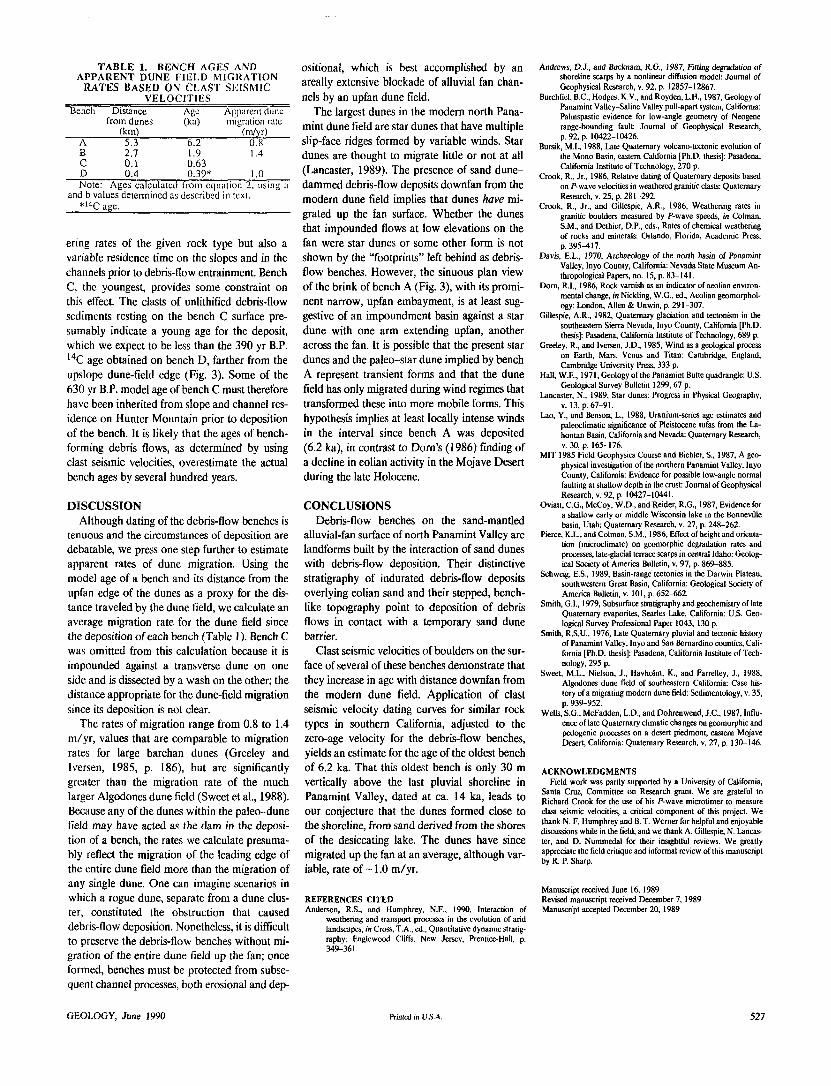
T A B L E 1. B E N C H AGES A N D A P P A R E N T D U N E FIELD MIGRATION
RATES BASED ON CLAST SEISMIC VELOCITIES
Bench Distance Age Apparent dune from dunes (ka) migration rate
(km) (m/yr) A 5.3 6.2 0.8 B 2.7 1.9 1.4 C 0.1 0.63 D 0.4 0.39* 1.0 Note: Ages calculated from equation 2, using a
and b values determined as described in text. * ' 4 C age.
ering rates of the given rock type but also a variable residence time on the slopes and in the channels prior to debris-flow entrainment. Bench C, the youngest, provides some constraint on this effect. The clasts of unlithified debris-flow sediments resting on the bench C surface pre-sumably indicate a young age for the deposit, which we expect to be less than the 390 yr B.P. 14C age obtained on bench D, farther from the upslope dune-field edge (Fig. 3). Some of the 630 yr B.P. model age of bench C must therefore have been inherited from slope and channel res-idence on Hunter Mountain prior to deposition of the bench. It is likely that the ages of bench-forming debris flows, as determined by using clast seismic velocities, overestimate the actual bench ages by several hundred years.
DISCUSSION Although dating of the debris-flow benches is
tenuous and the circumstances of deposition are debatable, we press one step further to estimate apparent rates of dune migration. Using the model age of a bench and its distance from the upfan edge of the dunes as a proxy for the dis-tance traveled by the dune field, we calculate an average migration rate for the dune field since the deposition of each bench (Table 1). Bench C was omitted from this calculation because it is impounded against a transverse dune on one side and is dissected by a wash on the other; the distance appropriate for the dune-field migration since its deposition is not clear.
The rates of migration range from 0.8 to 1.4 m/yr, values that are comparable to migration rates for large barchan dunes (Greeley and Iversen, 1985, p. 186), but are significantly greater than the migration rate of the much larger Algodones dune field (Sweet et al., 1988). Because any of the dunes within the paleo-dune field may have acted as the dam in the deposi-tion of a bench, the rates we calculate presuma-bly reflect the migration of the leading edge of the entire dune field more than the migration of any single dune. One can imagine scenarios in which a rogue dune, separate from a dune clus-ter, constituted the obstruction that caused debris-flow deposition. Nonetheless, it is difficult to preserve the debris-flow benches without mi-gration of the entire dune field up the fan; once formed, benches must be protected from subse-quent channel processes, both erosional and dep-
ositional, which is best accomplished by an areally extensive blockade of alluvial fan chan-nels by an upfan dune field.
The largest dunes in the modern north Pana-mint dune field are star dunes that have multiple slip-face ridges formed by variable winds. Star dunes are thought to migrate little or not at all (Lancaster, 1989). The presence of sand dune-dammed debris-flow deposits downfan from the modern dune field implies that dunes have mi-grated up the fan surface. Whether the dunes that impounded flows at low elevations on the fan were star dunes or some other form is not shown by the "footprints" left behind as debris-flow benches. However, the sinuous plan view of the brink of bench A (Fig. 3), with its promi-nent narrow, upfan embayment, is at least sug-gestive of an impoundment basin against a star dune with one arm extending upfan, another across the fan. It is possible that the present star dunes and the paleo-star dune implied by bench A represent transient forms and that the dune field has only migrated during wind regimes that transformed these into more mobile forms. This hypothesis implies at least locally intense winds in the interval since bench A was deposited (6.2 ka), in contrast to Dorn's (1986) finding of a decline in eolian activity in the Mojave Desert during the late Holocene.
CONCLUSIONS Debris-flow benches on the sand-mantled
alluvial-fan surface of north Panamint Valley are landforms built by the interaction of sand dunes with debris-flow deposition. Their distinctive stratigraphy of indurated debris-flow deposits overlying eolian sand and their stepped, bench-like topography point to deposition of debris flows in contact with a temporary sand dune barrier.
Clast seismic velocities of boulders on the sur-face of several of these benches demonstrate that they increase in age with distance downfan from the modern dune field. Application of clast seismic velocity dating curves for similar rock types in southern California, adjusted to the zero-age velocity for the debris-flow benches, yields an estimate for the age of the oldest bench of 6.2 ka. That this oldest bench is only 30 m vertically above the last pluvial shoreline in Panamint Valley, dated at ca. 14 ka, leads to our conjecture that the dunes formed close to the shoreline, from sand derived from the shores of the desiccating lake. The dunes have since migrated up the fan at an average, although var-iable, rate of ~ 1.0 m/yr.
R E F E R E N C E S C I T E D Anderson, R.S., and Humphrey, N.F., 1990, Interaction of
weathering and transport processes in the evolution of arid landscapes, in Cross, T.A., ed., Quantitative dynamic stratig-raphy: Englewood Cliffs, New Jersey, Prentice-Hall, p. 349-361.
Andrews, D.J., and Bucknam, R.G., 1987, Fitting degradation of shoreline scarps by a nonlinear diffusion model: Journal of Geophysical Research, v. 92, p. 12857-12867.
Burchfiel, B.C., Hodges, K.V, and Royden, L.H., 1987, Geology of Panamint Valley-Saline Valley pull-apart system, California: Palinspastic evidence for low-angle geometry of Neogene range-bounding fault: Journal of Geophysical Research, p. 92, p. 10422-10426.
Bursik, M.I., 1988, Late Quaternary volcano-tectonic evolution of the Mono Basin, eastern California [Ph.D. thesis]: Pasadena, California Institute of Technology, 270 p.
Crook, R., Jr., 1986, Relative dating of Quaternary deposits based on P-wave velocities in weathered granitic clasts: Quaternary Research, v. 25, p. 281-292.
Crook, R., Jr., and Gillespie, A.R., 1986, Weathering rates in granitic boulders measured by P-wave speeds, in Colman, S.M., and Dethier, D.P., eds., Rates of chemical weathering of rocks and minerals: Orlando, Florida, Academic Press, p. 395-417.
Davis, E.L., 1970, Archaeology of the north basin of Panamint Valley, Inyo County, California: Nevada State Museum An-thropological Papers, no. 15, p. 83-141.
Dom, R.I., 1986, Rock varnish as an indicator of aeolian environ-mental change, in Nickling, W.G., ed., Aeolian geomorphol-ogy: London, Allen & Unwin, p. 291-307.
Gillespie, A.R., 1982, Quaternary glaciation and tectonism in the southeastern Sierra Nevada, Inyo County, California [Ph.D. thesis]: Pasadena, California Institute of Technology, 689 p.
Greeley, R., and Iversen, J.D., 1985, Wind as a geological process on Earth, Mars, Venus and Titan: Cambridge, England, Cambridge University Press, 333 p.
Hall, W.E., 1971, Geology of the Panamint Butte quadrangle: U.S. Geological Survey Bulletin 1299,67 p.
Lancaster, N., 1989, Star dunes: Progress in Physical Geography, v. 13, p. 67-91.
Lao, Y., and Benson, L., 1988, Uranium-series age estimates and paleoclimatic significance of Pleistocene tufas from the La-hontan Basin, California and Nevada: Quaternary Research, v. 30, p. 165-176.
MIT 1985 Field Geophysics Course and Biehler, S., 1987, A geo-physical investigation of the northern Panamint Valley, Inyo County, California: Evidence for possible low-angle normal faulting at shallow depth in the crust: Journal of Geophysical Research, v. 92, p. 10427-10441.
Oviatt, C.G., McCoy, W.D., and Reider, R.G., 1987, Evidence for a shallow early or middle Wisconsin lake in the Bonneville basin, Utah: Quaternary Research, v. 27, p. 248-262.
Pierce, K.I , and Colman, S.M., 1986, Effect of height and orienta-tion (microclimate) on geomorphic degradation rates and processes, late-glacial terrace scarps in central Idaho: Geolog-ical Society of America Bulletin, v. 97, p. 869-885.
Schweig, E.S., 1989, Basin-range tectonics in the Darwin Plateau, southwestern Great Basin, California: Geological Society of America Bulletin, v. 101, p. 652-662.
Smith, G.I., 1979, Subsurface stratigraphy and geochemistry of late Quaternary evaporites, Searles Lake, California: U.S. Geo-logical Survey Professional Paper 1043,130 p.
Smith, R.S.U., 1976, Late Quaternary pluvial and tectonic history of Panamint Valley, Inyo and San Bernardino counties, Cali-fornia [Ph.D. thesis]: Pasadena, California institute of Tech-nology, 295 p.
Sweet, M.L., Nielson, J., Havholm, K., and Farrelley, J., 1988, Algodones dune field of southeastern California: Case his-tory of a migrating modern dune field: Sedimentology, v. 35, p. 939-952.
Wells, S.G., McFadden, L.D., and Dohrenwend, J.C., 1987, Influ-ence of late Quaternary climatic changes on geomorphic and pedogenic processes on a desert piedmont, eastern Mojave Desert, California: Quaternary Research, v. 27, p. 130-146.
A C K N O W L E D G M E N T S Field work was partly supported by a University of California,
Santa Cruz, Committee on Research grant. W e are grateful to Richard Crook for the use of his P- wave microtimer to measure clast seismic velocities, a critical component of this project. We thank N. F. Humphrey and B. T. Werner for helpful and enjoyable discussions while in the field, and we thank A. Gillespie, N. Lancas-ter, and D. Nummedal for their insightful reviews. We greatly appreciate the field critique and informal review of this manuscript by R. P. Sharp.
Manuscript received June 16, 1989 Revised manuscript received December 7, 1989 Manuscript accepted December 20, 1989
GEOLOGY, June 1990 Printed in U.S.A. 527