Dear Advanced Placement Human Geography Students, · Dear Advanced Placement Human Geography...
26
513.821.3044 | 711 E. Columbia Ave., Cincinnati, OH 45215 | www.mndhs.org May 22, 2017 Dear Advanced Placement Human Geography Students, Welcome to the Mount Notre Dame learning community! As noted in the Course Selection Book, there is a summer assignment required for AP Human Geography. The purpose of this assignment is to prepare you for our course. The assignment is specifically designed to help familiarize you with the location of key world regions, landforms and cities, and to strengthen your critical thinking and note-taking abilities. The files for our assignments can be found on the Academics section of the MND website. Go to www.mndhs.org, click the Academics link at the top of the page, and then click on the Summer Assignments link on the left side. You will see the following two files associated with this course: Advanced Placement Human Geography Welcome Letter and Map Packet World Geography; Building a Global Perspective Chapter One Section One The first part of your assignment is to complete the enclosed map packet. It is expected that students will have their map packet completed the first day of AP Human Geography class. Packets will be graded for completion and then returned to students to be utilized to study for map quizzes that will occur throughout the course. To prepare you for success on the AP exam, tests will be difficult. Therefore, map quizzes can be an excellent grade booster, so take your time preparing your maps so that they will be an excellent resource to study from. Mount Notre Dame will provide an atlas which can be used to complete this assignment. The atlas can be picked up from the main office during the summer and is yours to keep. The second part of your assignment will be to read and take your own digital notes on chapter one, section one of World Geography; Building a Global Perspective. It is important that you begin the process of becoming familiar with the basic concepts before the actual class begins. Our time together is limited, and the amount of material to be covered is vast. In order to gain the most benefit from our time together we want to build upon a strong base as soon as possible. It is important to acclimate to the material so you can come to class with some exposure and we can take it to the collegiate level. You are truly prepared when you have a firm grasp of what you think you know as well as what you would like further clarification on.
Transcript of Dear Advanced Placement Human Geography Students, · Dear Advanced Placement Human Geography...
513.821.3044 | 711 E. Columbia Ave., Cincinnati, OH 45215 | www.mndhs.org
May 22, 2017
Dear Advanced Placement Human Geography Students, Welcome to the Mount Notre Dame learning community! As noted in the Course Selection Book, there is a summer assignment required for AP Human Geography. The purpose of this assignment is to prepare you for our course. The assignment is specifically designed to help familiarize you with the location of key world regions, landforms and cities, and to strengthen your critical thinking and note-taking abilities.
The files for our assignments can be found on the Academics section of the MND website. Go to www.mndhs.org, click the Academics link at the top of the page, and then click on the Summer Assignments link on the left side. You will see the following two files associated with this course: Advanced Placement Human Geography Welcome Letter and Map Packet
World Geography; Building a Global Perspective Chapter One Section One
The first part of your assignment is to complete the enclosed map packet. It is expected that students will have their map packet completed the first day of AP Human Geography class. Packets will be graded for completion and then returned to students to be utilized to study for map quizzes that will occur throughout the course. To prepare you for success on the AP exam, tests will be difficult. Therefore, map quizzes can be an excellent grade booster, so take your time preparing your maps so that they will be an excellent resource to study from. Mount Notre Dame will provide an atlas which can be used to complete this assignment. The atlas can be picked up from the main office during the summer and is yours to keep.
The second part of your assignment will be to read and take your own digital notes on chapter one, section one of World Geography; Building a Global Perspective. It is important that you begin the process of becoming familiar with the basic concepts before the actual class begins. Our time together is limited, and the amount of material to be covered is vast. In order to gain the most benefit from our time together we want to build upon a strong base as soon as possible. It is important to acclimate to the material so you can come to class with some exposure and we can take it to the collegiate level. You are truly prepared when you have a firm grasp of what you think you know as well as what you would like further clarification on.
The requirement to take digital notes on what you read is very important. The collegiate text assignment is very dense and full of definitions, examples, statistics, and case studies. This high school level intro will serve you well. There are no specific requirements for your notes regarding length, style, or format. I leave those
criteria completely open to you as a learner. As your instructor I will look at your notes to get a sense of your individual learning style and current method of organizing complex information. That will form a baseline from which we will attempt to improve your effectiveness and efficiency.
The textbook material will be made available to you as a PDF file. This will also be due during our first class together and will be posted to our class Schoology page. Advanced Placement Human Geography is the equivalent of a collegiate level Human Geography course, and all students enrolled in this course must be committed to a rigorous course load. Keep in mind the following: Students who fail to complete, or do poorly on their summer assignment, will have their placement in the course reevaluated and may lose their placement in the course. Please take this assignment seriously.
Please feel free to contact me should you have any questions at all. I can be reached at [email protected] at any time. I would like to congratulate you on your academic achievement. I am confidant you will find great success at Mount Notre Dame and I look forward to helping you explore our world!
All the best,
Benn VanOudenallen Social Studies Department Mount Notre Dame High School
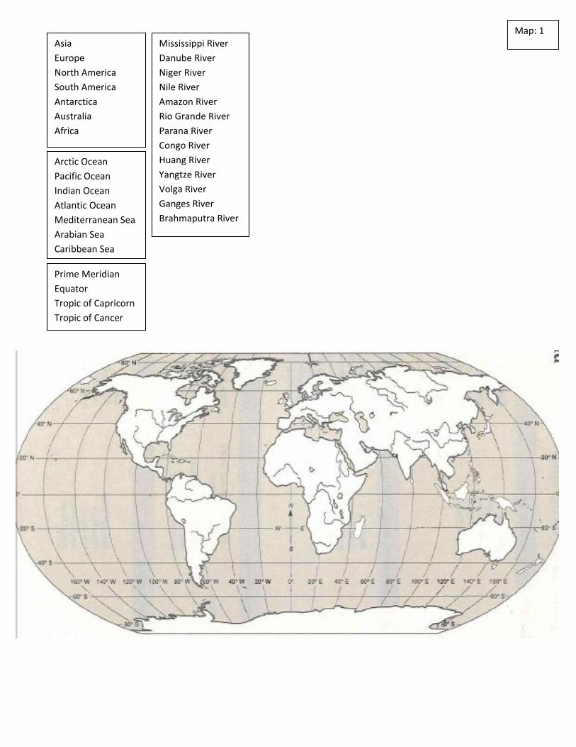
Map: 1 Asia
Europe
North America
South America
Antarctica
Australia
Africa
Prime Meridian
Equator
Tropic of Capricorn
Tropic of Cancer
Arctic Ocean
Pacific Ocean
Indian Ocean
Atlantic Ocean
Mediterranean Sea
Arabian Sea
Caribbean Sea
Mississippi River
Danube River
Niger River
Nile River
Amazon River
Rio Grande River
Parana River
Congo River
Huang River
Yangtze River
Volga River
Ganges River
Brahmaputra River
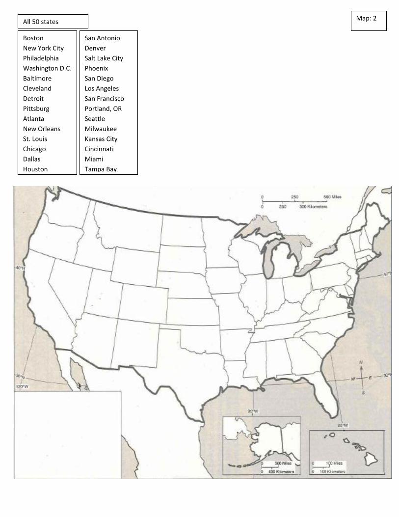
Map: 2 All 50 states
Boston
New York City
Philadelphia
Washington D.C.
Baltimore
Cleveland
Detroit
Pittsburg
Atlanta
New Orleans
St. Louis
Chicago
Dallas
Houston
San Antonio
Denver
Salt Lake City
Phoenix
San Diego
Los Angeles
San Francisco
Portland, OR
Seattle
Milwaukee
Kansas City
Cincinnati
Miami
Tampa Bay
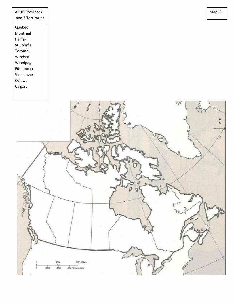
Map: 3 All 10 Provinces
and 3 Territories
Quebec
Montreal
Halifax
St. John’s
Toronto
Windsor
Winnipeg
Edmonton
Vancouver
Ottawa
Calgary
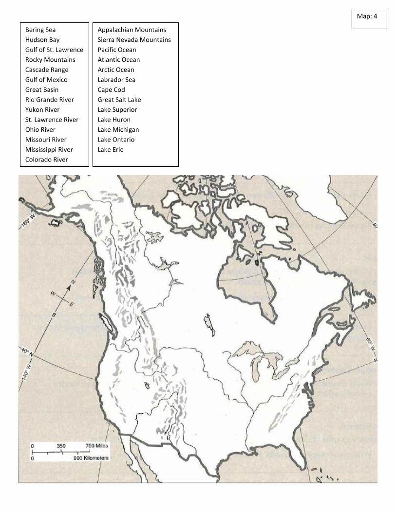
Map: 4
Bering Sea
Hudson Bay
Gulf of St. Lawrence
Rocky Mountains
Cascade Range
Gulf of Mexico
Great Basin
Rio Grande River
Yukon River
St. Lawrence River
Ohio River
Missouri River
Mississippi River
Colorado River
Appalachian Mountains
Sierra Nevada Mountains
Pacific Ocean
Atlantic Ocean
Arctic Ocean
Labrador Sea
Cape Cod
Great Salt Lake
Lake Superior
Lake Huron
Lake Michigan
Lake Ontario
Lake Erie
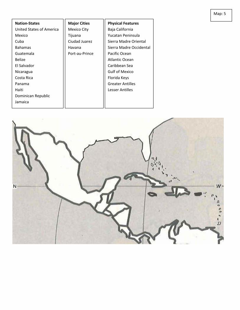
Map: 5
Nation-States
United States of America
Mexico
Cuba
Bahamas
Guatemala
Belize
El Salvador
Nicaragua
Costa Rica
Panama
Haiti
Dominican Republic
Jamaica
Major Cities
Mexico City
Tijuana
Ciudad Juarez
Havana
Port-au-Prince
Physical Features
Baja California
Yucatan Peninsula
Sierra Madre Oriental
Sierra Madre Occidental
Pacific Ocean
Atlantic Ocean
Caribbean Sea
Gulf of Mexico
Florida Keys
Greater Antilles
Lesser Antilles

Map: 6
Nation-States
Ecuador
Colombia
Venezuela
Guyana
Suriname
French Guiana
Brazil
Peru
Bolivia
Ecuador
Paraguay
Argentina
Uruguay
Chile
Major Cities
Brasilia
Sao Paulo
Rio de Janeiro
Caracas
Bogota
Cali
Medellin
Buenos Aires

Map: 7
Physical Features
Atlantic Ocean
Pacific Ocean
Orinoco River
Amazon River
Amazon Basin
Andes Mountains
Atacama Desert
Gran Chaco
Pampas
Rio de la Plata
Parana River
Cape Horn
Strait of Magellan
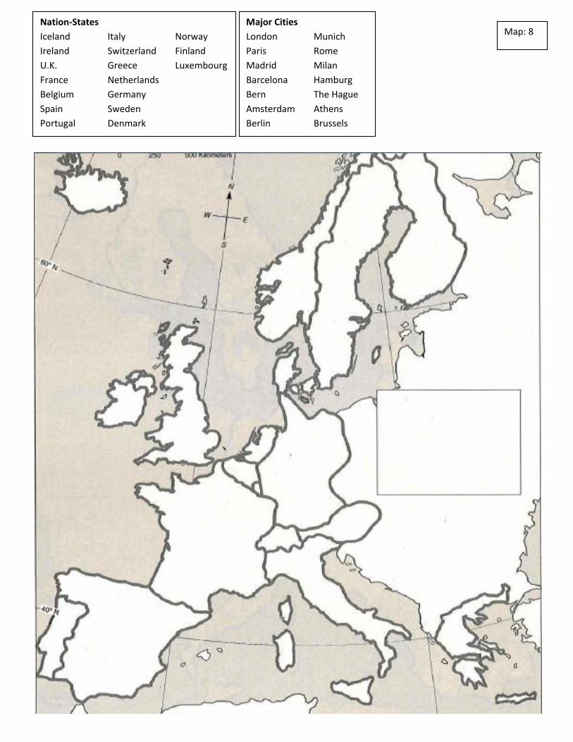
Map: 8 Nation-States
Iceland Italy Norway
Ireland Switzerland Finland
U.K. Greece Luxembourg
France Netherlands
Belgium Germany
Spain Sweden
Portugal Denmark
Major Cities
London Munich
Paris Rome
Madrid Milan
Barcelona Hamburg
Bern The Hague
Amsterdam Athens
Berlin Brussels
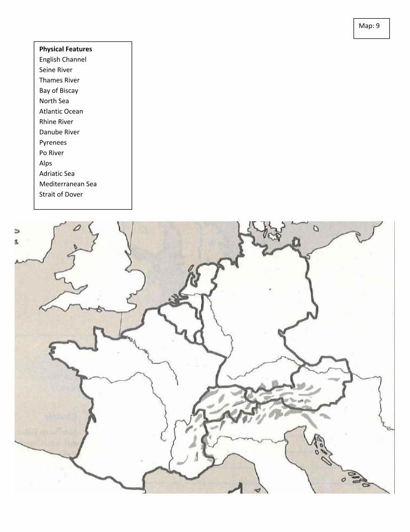
Map: 9
Physical Features
English Channel
Seine River
Thames River
Bay of Biscay
North Sea
Atlantic Ocean
Rhine River
Danube River
Pyrenees
Po River
Alps
Adriatic Sea
Mediterranean Sea
Strait of Dover
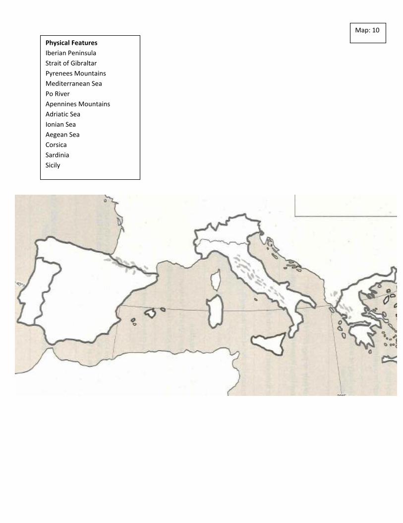
Map: 10
Physical Features
Iberian Peninsula
Strait of Gibraltar
Pyrenees Mountains
Mediterranean Sea
Po River
Apennines Mountains
Adriatic Sea
Ionian Sea
Aegean Sea
Corsica
Sardinia
Sicily
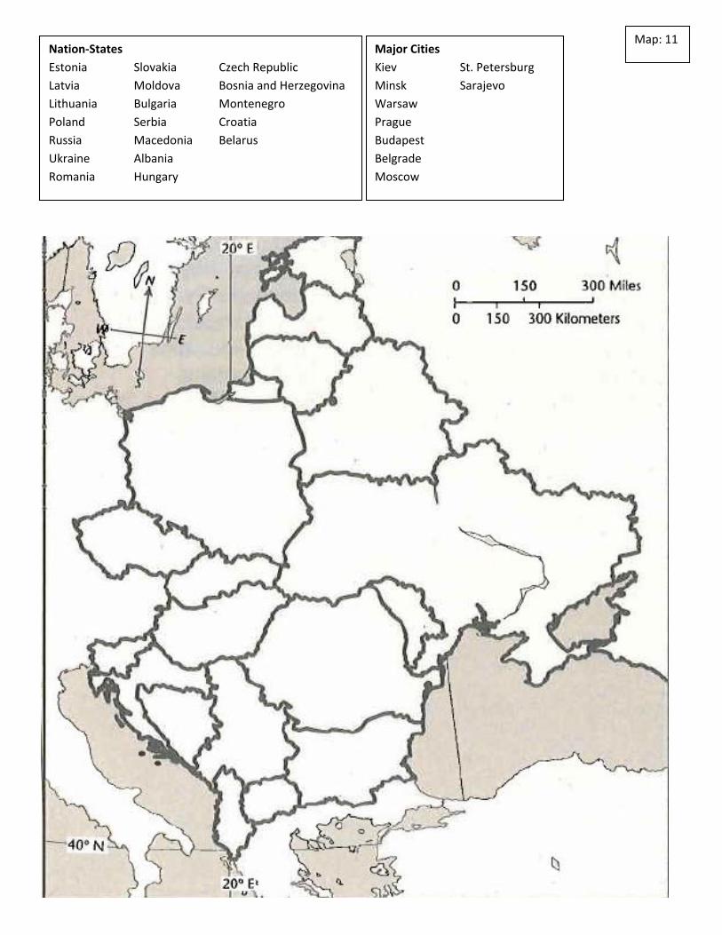
Map: 11 Nation-States
Estonia Slovakia Czech Republic
Latvia Moldova Bosnia and Herzegovina
Lithuania Bulgaria Montenegro
Poland Serbia Croatia
Russia Macedonia Belarus
Ukraine Albania
Romania Hungary
Major Cities
Kiev St. Petersburg
Minsk Sarajevo
Warsaw
Prague
Budapest
Belgrade
Moscow
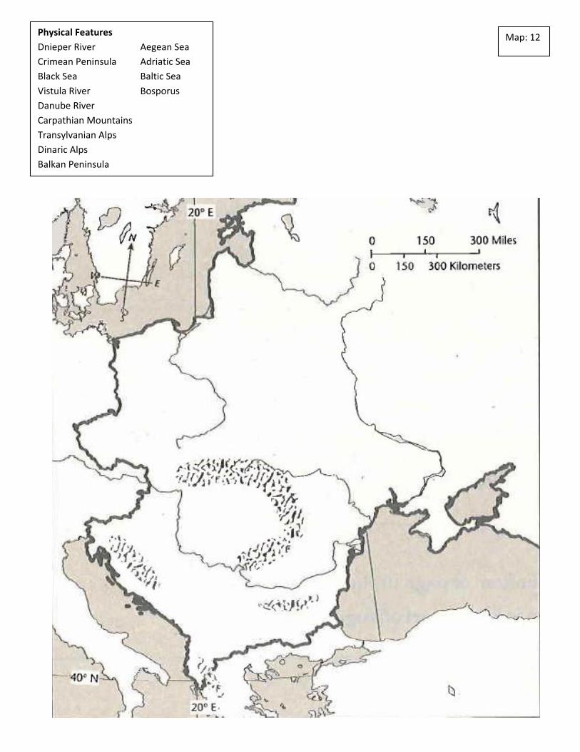
Map: 12 Physical Features
Dnieper River Aegean Sea
Crimean Peninsula Adriatic Sea
Black Sea Baltic Sea
Vistula River Bosporus
Danube River
Carpathian Mountains
Transylvanian Alps
Dinaric Alps
Balkan Peninsula
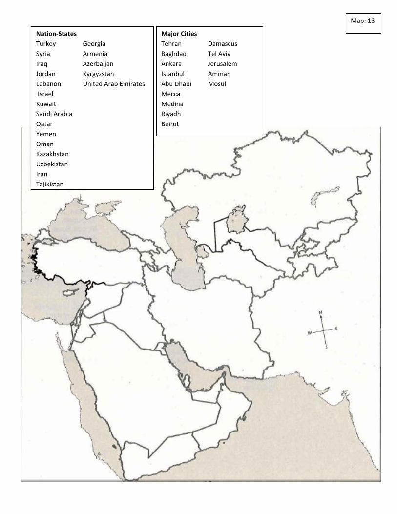
Map: 13
Nation-States
Turkey Georgia
Syria Armenia
Iraq Azerbaijan
Jordan Kyrgyzstan
Lebanon United Arab Emirates
Israel
Kuwait
Saudi Arabia
Qatar
Yemen
Oman
Kazakhstan
Uzbekistan
Iran
Tajikistan
Major Cities
Tehran Damascus
Baghdad Tel Aviv
Ankara Jerusalem
Istanbul Amman
Abu Dhabi Mosul
Mecca
Medina
Riyadh
Beirut
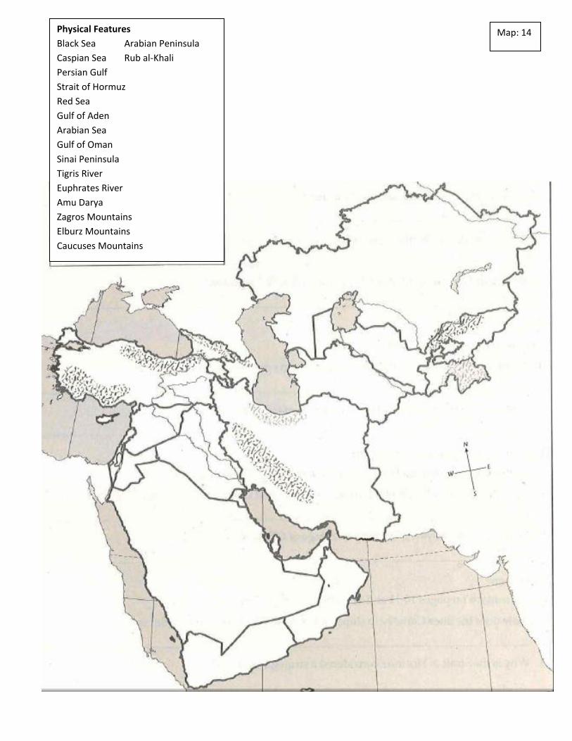
Map: 14 Physical Features
Black Sea Arabian Peninsula
Caspian Sea Rub al-Khali
Persian Gulf
Strait of Hormuz
Red Sea
Gulf of Aden
Arabian Sea
Gulf of Oman
Sinai Peninsula
Tigris River
Euphrates River
Amu Darya
Zagros Mountains
Elburz Mountains
Caucuses Mountains
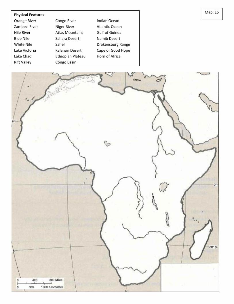
Map: 15 Physical Features
Orange River Congo River Indian Ocean
Zambezi River Niger River Atlantic Ocean
Nile River Atlas Mountains Gulf of Guinea
Blue Nile Sahara Desert Namib Desert
White Nile Sahel Drakensburg Range
Lake Victoria Kalahari Desert Cape of Good Hope
Lake Chad Ethiopian Plateau Horn of Africa
Rift Valley Congo Basin
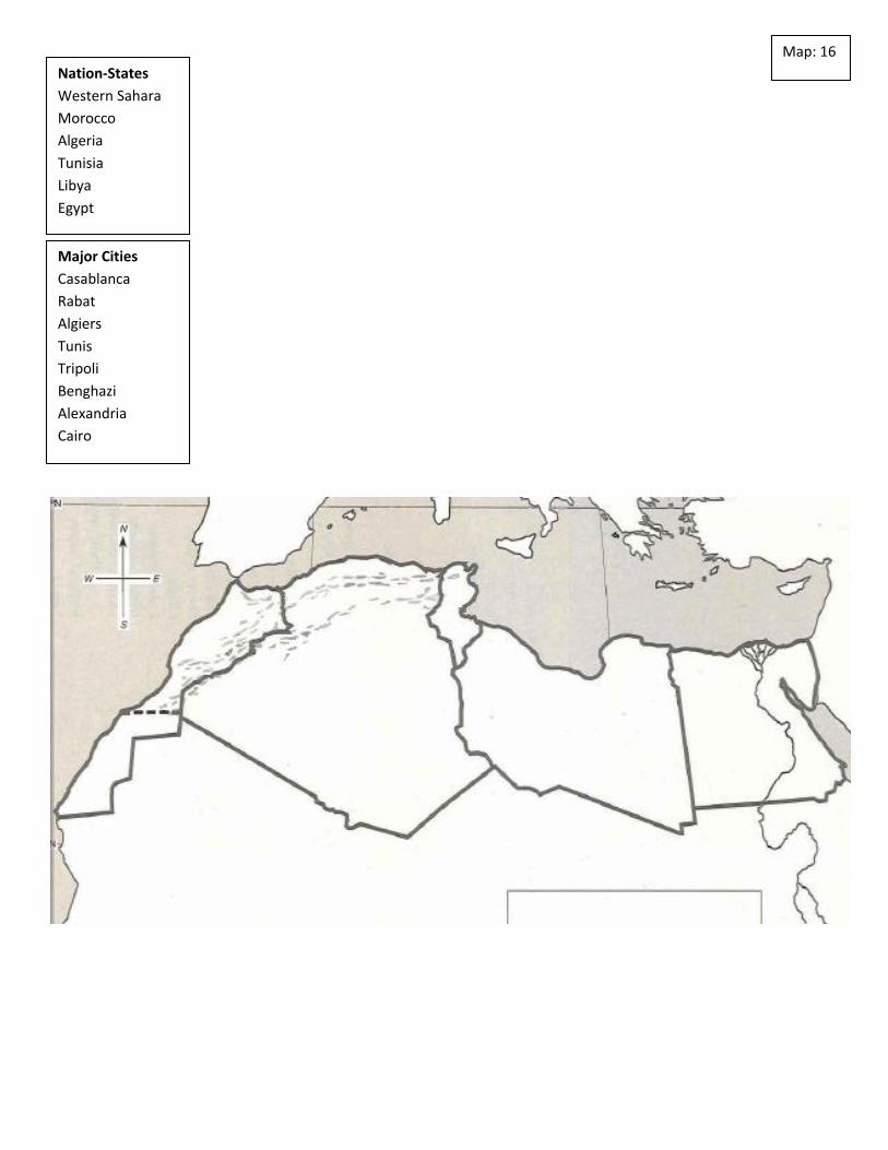
Map: 16
Nation-States
Western Sahara
Morocco
Algeria
Tunisia
Libya
Egypt
Major Cities
Casablanca
Rabat
Algiers
Tunis
Tripoli
Benghazi
Alexandria
Cairo

Map: 17 Nation-States Major Cities
Mauritania Dakar
Mali Freetown
The Gambia Monrovia
Guinea Accra
Senegal Abuja
Sierra Leone Lagos
Liberia Kinshasa
Cote D’Ivoire Abidjan
Ghana
Niger
Nigeria
Chad
Cameroon
Gabon
Congo
Democratic Rep. of the Congo
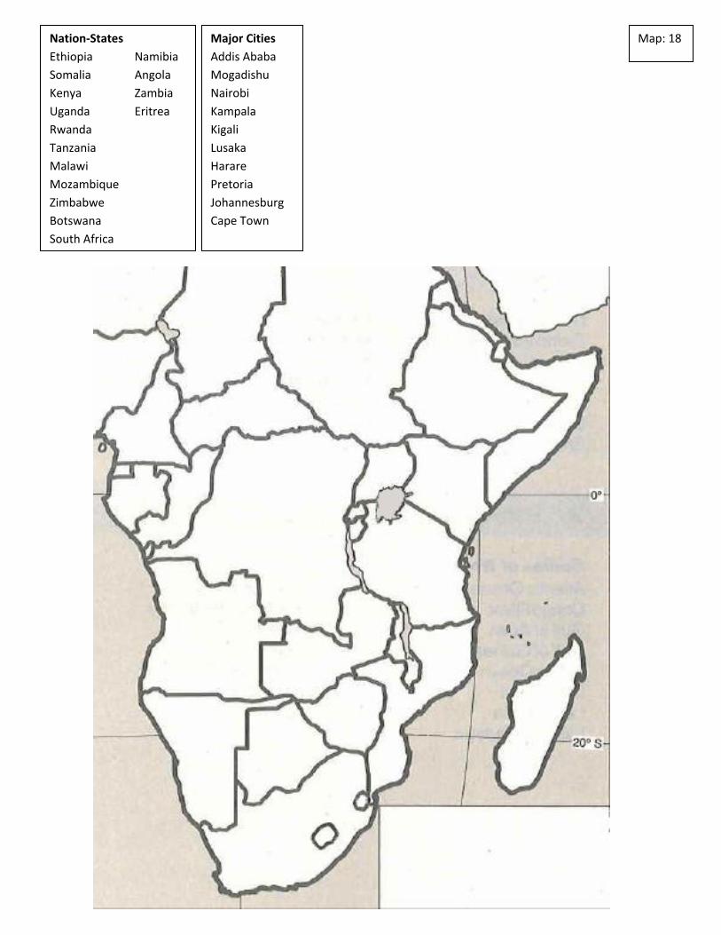
Map: 18 Nation-States
Ethiopia Namibia
Somalia Angola
Kenya Zambia
Uganda Eritrea
Rwanda
Tanzania
Malawi
Mozambique
Zimbabwe
Botswana
South Africa
Major Cities
Addis Ababa
Mogadishu
Nairobi
Kampala
Kigali
Lusaka
Harare
Pretoria
Johannesburg
Cape Town

Map: 19
Physical Features
Gobi Desert
Himalayas
Plateau of Tibet
Huang River
Yangtze River
Manchuria
Tien Shan Mountains
Sea of Japan
East China Sea
Taiwan Strait
Korea Strait

Map: 20 Nation-States
China Taiwan Indonesia
Mongolia Laos
North Korea Cambodia
South Korea Thailand
Japan Philippines
Vietnam Malaysia
Major Cities
Beijing Pyongyang
Chongqing Ha Noi
Hong Kong Bangkok
Shanghai Kuala Lumpur
Taipei Manila
Seoul Jakarta

Map: 21 Nation-States
Afghanistan
Pakistan
India
Bangladesh
Bhutan
Nepal
Sri Lanka
Major Cities
Kabul
Islamabad
New Delhi
Mumbai
Kolkata
Kathmandu
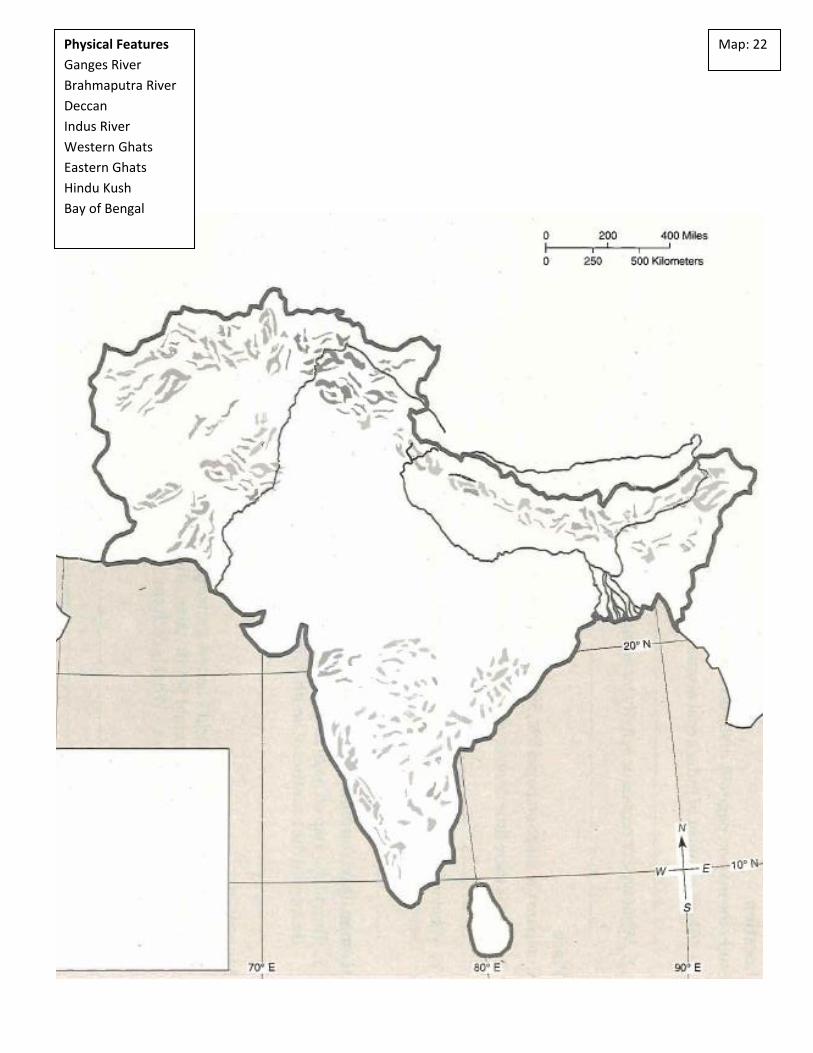
Map: 22 Physical Features
Ganges River
Brahmaputra River
Deccan
Indus River
Western Ghats
Eastern Ghats
Hindu Kush
Bay of Bengal

Map: 23 Physical Features
Malay Peninsula
Sumatra
Java
Borneo
South China Sea
Gulf of Thailand
Mekong River
Gulf of Tonkin
Strait of Malacca
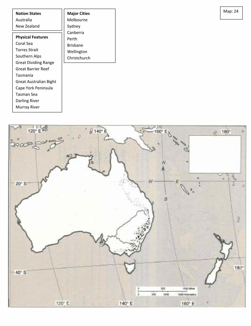
Map: 24 Nation States
Australia
New Zealand
Physical Features
Coral Sea
Torres Strait
Southern Alps
Great Dividing Range
Great Barrier Reef
Tasmania
Great Australian Bight
Cape York Peninsula
Tasman Sea
Darling River
Murray River
Major Cities
Melbourne
Sydney
Canberra
Perth
Brisbane
Wellington
Christchurch