
DDS OF LANDS DEPARTMENT · DDS OF LANDS DEPARTMENT SUPPLEMENTARY FEASIBILITY STUDY REPORT DATA...
91
DDS OF LANDS DEPARTMENT SUPPLEMENTARY FEASIBILITY STUDY REPORT DATA SPECIFICATION Ref. No. : T122 June, 2004 i Version : 1.0 Amendment History Change Number Revision Description Pages Affected Revision Number Date
Transcript of DDS OF LANDS DEPARTMENT · DDS OF LANDS DEPARTMENT SUPPLEMENTARY FEASIBILITY STUDY REPORT DATA...

DDS OF LANDS DEPARTMENT SUPPLEMENTARY FEASIBILITY STUDY REPORT DATA SPECIFICATION
Ref. No. : T122 June, 2004 i Version : 1.0
Amendment History
Change Number
Revision Description
Pages Affected
Revision Number
Date

DDS OF LANDS DEPARTMENT SUPPLEMENTARY FEASIBILITY STUDY REPORT DATA SPECIFICATION
Ref. No. : T122 June, 2004 Page ii Version : 1.0
TABLE OF CONTENTS
2.4 DATA SPECIFICATION ............................................................................................ 2.4-1 2.4.1 Introduction........................................................................................................... 2.4-1 2.4.2 Proposed Lands Department Data Dissemination System ................................... 2.4-2
2.4.2.1 Source Spatial Data Hub .................................................................................. 2.4-2 2.4.2.2 Multi-format Spatial Data Hub ........................................................................ 2.4-3 2.4.2.3 Customer and Sales Record Subsystem ........................................................... 2.4-5 2.4.2.4 CSU Data ......................................................................................................... 2.4-6
2.4.2.4.1 Building CSU ....................................................................................... 2.4-6 2.4.2.4.2 Lot CSU ............................................................................................... 2.4-8 2.4.2.4.3 Road Centreline CSU......................................................................... 2.4-10
2.4.3 Required System Logical Data Structure ........................................................... 2.4-11 2.4.4 Required System Entity Description .................................................................. 2.4-17
2.4.4.1 Entity Description (Part I – Volumetric for Each Entity (Year 1))................ 2.4-17 2.4.4.1.1 Source Spatial Data Hub .................................................................... 2.4-18 2.4.4.1.2 Multi-format Spatial Data Hub .......................................................... 2.4-19 2.4.4.1.3 Customer and Sales Record Subsystem ............................................. 2.4-25 2.4.4.1.4 CSU Entities....................................................................................... 2.4-28
2.4.4.2 Entity Description (Part II –Data Item Description) ...................................... 2.4-36 2.4.4.2.1 Entities in the Source Spatial Data Hub............................................. 2.4-37 2.4.4.2.2 Entities in Multi-format Spatial Data Hub ......................................... 2.4-38 2.4.4.2.3 Entities in Customer and Sales Record Subsystem............................ 2.4-41 2.4.4.2.4 CSU Entities....................................................................................... 2.4-46

DDS OF LANDS DEPARTMENT SUPPLEMENTARY FEASIBILITY STUDY REPORT DATA SPECIFICATION
Ref. No. : T122 June, 2004 Page 2.4-1 Version : 1.0
2.4 DATA SPECIFICATION
2.4.1 Introduction
The purpose of this document is to describe the content and specification of the digital map data and customer and sales records in the proposed Computerized Land Information System (CLIS) Data Dissemination System (DDS) and the data specification of the Building, Lot and Road Centreline Common Spatial Units (CSU) for the CSU DDS of the integrated LandsD DDS. The data volume information etc. contained in this document will provide input to the calculation of the data storage in Technical System Architecture. The digital map data will be extracted from the currently stored mapping libraries within the systems in LandsD, where digital map data are combined with attribute data. In addition, topological relationships between vector features are also maintained in that system. The data model consists of a series of attribute tables and look-up tables with layers built upon a map scale of 1:1000, 1:5000, 1:10000, 1:20000 for storing digital map, cadastral and geo-reference information. Each layer is discrete by itself and is uniquely defined to represent a different set of characteristics. With reference to the User Requirements (UR), the demand for the historical digital map data is small and it is recommended that current procedures should be used to meet those requirements. Hence, the historical digital map data is not required to be included in this document. LandsD would convert existing spatial data into seamless spatial data with the DAMin/DAMout module and relevant DO of individual CSU would input their data to the CSU DDS to form the initial set of CSU data in the Centralized CSU database. The initial CSU data set of each of the three CSUs would be distributed to individual Data Users. Periodically, respective Data Owners would provide updates on those data items under their jurisdiction. Being the Data Agent, LandsD would provide in the CSU DDS facilities (CSU Data Provision from DO and data validation) for this purpose. Then facilities will be provided for CSU Data Manipulation which would manipulate the loaded CSU data and update the existing CSU data kept in the centralised spatial database accordingly. CSU Data Dissemination to DU facilities would be provided to allow Data Users to download those updated CSU data (delta data) periodically to obtain the latest information they are interested.

DDS OF LANDS DEPARTMENT SUPPLEMENTARY FEASIBILITY STUDY REPORT DATA SPECIFICATION
Ref. No. : T122 June, 2004 Page 2.4-2 Version : 1.0
2.4.2 Proposed Lands Department Data Dissemination System
2.4.2.1 Source Spatial Data Hub
A Source Spatial Data Hub is proposed to extract a copy of the digital map data from the master set of current mapping libraries residing within CLIS and store it into the Hub itself. The purpose of this Hub is to separate the digital map data for dissemination from the current master set of CLIS to avoid any interruption on the daily operation of CLIS. At the initial set-up, the entire set of digital map data will be extracted from CLIS. However after that, only changed or updated layers will be extracted on a daily basis. The digital map data stored in this Hub is listed as follows: • B1000, B5000 in Arc/Info native format (Arc/Info 6.x Coverage) • B10000, B20000 in DGN format • C1000 in Arc/Info native format • G1000 in Arc/Info native format

DDS OF LANDS DEPARTMENT SUPPLEMENTARY FEASIBILITY STUDY REPORT DATA SPECIFICATION
Ref. No. : T122 June, 2004 Page 2.4-3 Version : 1.0
2.4.2.2 Multi-format Spatial Data Hub
A Multi-format Spatial Data Hub is proposed to store the digital map data from the Source Spatial Data Hub (without those restricted layers such as proposed layers in Digital Land Boundary Database) in a number of standard data formats, which can be readily made available to any customers for dissemination. With reference to the UR, it identifies that the LandsD DDS allows read access to all up-to-date data dictionaries (Access rights should only be granted to customers who have purchased the original copy of the data dictionary and also have a valid licence). These data dictionaries are proposed to be kept in the Multi-format Spatial Data Hub. Whenever the data dictionary is upgraded, the old version will also be stored in this Hub along with the latest version. However, when more than 10 versions of the data dictionaries are accumulated, the oldest version of data dictionary will be purged from the Hub. With respect to the requirement of disseminating digital data supplied by other government departments, as mentioned in UR, it is proposed that LandsD will only be responsible for serving those digital data and not the maintenance and updating of the data. The formats of the digital map data stored in this Hub are tabulated as follows:
Types of Product Product Name Data Format B1000 B5000 B10000
Digital Topographic Map Database
B20000 Digital Land Boundary Database C1000
BG1000 Building Polygon* SG1000 Site Polygon
Geo-Reference Database (G1000)
RG1000 Road Centre Line
• Arc/Info Export (E00) • ASCII (ArcInfo Ungenerate) • Microstation Design File (DGN) • AutoCAD Drawing File (DWG) • AutoCAD Data Exchange Format
(DXF) • Tagged Interchange File Format
(TIFF) for B5000, B10000 and B20000
Digital Orthophoto Tagged Interchange File Format (TIFF), Enhanced Compressed Wavelet (ECW) and Multi-resolution Seamless Image Database (MrSID) for DOP5000 / DOP10000 provides seamless digital aerial images rectified for image displacement in the whole territory of HKSAR
GeoCom Database MS Excel Format
Data Dictionaries An area will be reserved in the proposed LandsD DDS to facilitate the read access of data dictionaries by the customers
Digital data from other Government departments
An area will be reserved in the proposed DDS to facilitate the dissemination of the digital data provided by other Government departments
*BG1000 only has the ASCII format At the initial set-up of the Multi-format Spatial Data Hub, The whole set of digital map data from the Source Spatial Data Hub will be converted
into the required data format as stated above. Subsequently, only updated sheets in the Source Spatial Data Hub will be converted and stored into the Multi-format Spatial Data Hub in a batch mode on a daily basis

DDS OF LANDS DEPARTMENT SUPPLEMENTARY FEASIBILITY STUDY REPORT DATA SPECIFICATION
Ref. No. : T122 June, 2004 Page 2.4-4 Version : 1.0
The whole set of latest version of data dictionaries will be copied into the designated area
The entire copy of digital data supplied by other Government departments will be copied into the designated area
In addition, the main benefit of this Hub is the ability to disseminate different format of LandsD digital map data, data dictionary and the digital data supplied by other Government departments, to the customers without performing complex processing.

DDS OF LANDS DEPARTMENT SUPPLEMENTARY FEASIBILITY STUDY REPORT DATA SPECIFICATION
Ref. No. : T122 June, 2004 Page 2.4-5 Version : 1.0
2.4.2.3 Customer and Sales Record Subsystem
A Customer and Sales Record Subsystem is proposed to maintain customer records as described in the UR. It aims to support various functions described below: • Customer profile – New customer profile can be maintained in the database of the
Subsystem. A customer is allowed to access the proposed dissemination system based on the customer information records stored in the database. Different levels of functions are provided to different categories of customers. For example, only licenced customers would be allowed to access the data dictionary online.
• Monitoring and maintaining the order of digital map data, licence and cessation
records – The revision details and the order records of the digital map products will be maintained. Notification can be issued to the customer whenever the digital map data is updated and changed. Validation of data licence records and cessation data for the Government consultants can also be maintained.
• Delivery and payment – It will store the delivery and payment method selected by the
customer.

DDS OF LANDS DEPARTMENT SUPPLEMENTARY FEASIBILITY STUDY REPORT DATA SPECIFICATION
Ref. No. : T122 June, 2004 Page 2.4-6 Version : 1.0
2.4.2.4 CSU Data
2.4.2.4.1 Building CSU
The Building CSU data is essential to the business of the departments of HPLB and required for the works projects of works departments of ETWB. The Building CSU are maintained by 5 Data Owners (ArchSD, BD, LandsD, PlanD and RVD) and used among the 5 Data Users (BD, C&SD, LandsD, PlanD and RVD). The CSU would keep useful information which is frequently shared among PDs for facilitate their daily business needs. These data include Spatial building records from LandsD, approved building plans and Occupation Permit records from BD and building address location reference from RVD. Since there are different PDs involved as Data Owners in the Building CSU and some data are used in different PDs with different names or definitions, clear and well defined roles should be aligned among these PDs to remove any data inconsistence. Details of individual data items in the CSU maintained by responsible PDs are listed in Table 2.4.2-1. PD Entity Ownership1
Building Geographical Info F Building Structural Info F Geo-Struct Mapping R
ArchSD
Data Provision Date R Building Geographical Info F Building Structural Info F Geo-Struct Mapping R Building OP Info T OP Info T Building Lot No In OP T
BD
Data Provision Date R Building Geographical Info F Proposed Tower Polygon T Proposed Podium Polygon T Active Tower Polygon T Active Podium Polygon T Demolished Tower Polygon T Demolished Podium Polygon T Building Structural Info F
LandsD2
Geo-Struct Mapping R
1 Mode of Ownership: T - the PD owns the entire entity; R - the PD owns all data items of particular records in the entity; F - the PD owns only particular data item(s) of particular record(s) in the entity.
2 LandsD would provide surveyed addresses for converted data for buildings constructed before implementation of DAM only. Hence, the Building Address entity is not included in the ongoing exchanged entity list above.

DDS OF LANDS DEPARTMENT SUPPLEMENTARY FEASIBILITY STUDY REPORT DATA SPECIFICATION
Ref. No. : T122 June, 2004 Page 2.4-7 Version : 1.0
PD Entity Ownership1 Development Name R Building Development Name R Building Name R Data Provision Date R Participating Department T
Renamed CSU T Building Geographical Info F Building Structural Info F Geo-Struct Mapping R
PlanD
Data Provision Date R Development Name R Building Development Name R Building Name R Building Address R Street Location T Street Name T Location Name T
RVD
Data Provision Date R
Table 2.4.2-1 - Ownership of Building Entities
As of September, 2003, the total number of active non-podium building records kept in LandsD is around 200,000 and active podium building records kept in PlanD is 2,000 respectively. Moreover, the number of private building (Category 1) records with OP issued by BD is 42,000.

DDS OF LANDS DEPARTMENT SUPPLEMENTARY FEASIBILITY STUDY REPORT DATA SPECIFICATION
Ref. No. : T122 June, 2004 Page 2.4-8 Version : 1.0
2.4.2.4.2 Lot CSU
According to the Land Survey Ordinance (1995), for every subdivision of land, a land boundary plan prepared and certified by an Authorized Land Surveyor is required for land registration. LandsD and LR are the 2 Data Owners to maintain the Lot CSU while BD, CED, DSD, LandsD, PlanD and RVD are the 6 Data Users interested in the Lot CSU data. Information flows related to lot CSU data among PDs are described as follows: LR will include the lot transaction information on the Memorial Day Book, which
will be distributed to PDs frequently. Works Departments would exchange lot information with LAO for land resumption
or other purpose for the implementation of the public works projects. DSO prepares land boundary plan, handles land status enquiries and provides survey
and mapping support to different Government departments. RVD collects the land grant document, resumption plan and cadastral map to
maintain its survey record plan and sales record plan. BD and RVD will make use of the address reference in the lot data to support their
businesses. BD requires lot information to process OP applications, lot clarification cases and
other administration, control and enforcement activities. Entities, solely or partially, owned by each Data Owner are summarised in Table 2.4.2-2. PD Entity Ownership3
Land Info T Cert of Compliance Date T Resumption Notice T Land Resumption Notice T Lot Type Name T Lot Type District T Land Classification T Area Unit T Land Ownership T Lease Condition Type T Lease Use T Lot Polygon T
LandsD
Overlap Lot Polygon T Lot Register T Lot Register Lot Type T Lot Register Area T
LR
Memorial T
3 Mode of Ownership: T - the PD owns the entire entity; R - the PD owns all data items of particular records in the entity; F - the PD owns only particular data item(s) of particular record(s) in the entity.

DDS OF LANDS DEPARTMENT SUPPLEMENTARY FEASIBILITY STUDY REPORT DATA SPECIFICATION
Ref. No. : T122 June, 2004 Page 2.4-9 Version : 1.0
PD Entity Ownership3 Lot Register Memorial T Memorial Nature T
Subdivision T
Table 2.4.2-2 - Ownership of Lot Entities
As at 2003, there is about 365,000 lot boundaries in LOT and OVERLAP LOT layers maintained in LandsD’s C1000 library. At at Feb., 2004, there is about 533,000 records kept in LR’s Land Registration System (LRS).

DDS OF LANDS DEPARTMENT SUPPLEMENTARY FEASIBILITY STUDY REPORT DATA SPECIFICATION
Ref. No. : T122 June, 2004 Page 2.4-10 Version : 1.0
2.4.2.4.3 Road Centreline CSU
With effect from 27 January 2000, LandsD is responsible for organizing and coordinating the naming of streets and roads and the processing of the gazetting of the names. Majority of the road network in the HKSAR is managed, operated and maintained by HyD while small percentage of the road work is maintained by other PDs (such as WSD, DSD etc). LandsD is the only Data Owner to provide and update the Road Centreline CSU while CED, DSD, HyD, LandsD and PlanD are the 5 Data Users of the Road Centreline CSU. PDs would use the road centreline information for the following purposes: To confirm the location, the street name and street types for reference by projects
and/or services. To communicate with other PDs for planning, operation and management of the road
network. To form a backdrop of the GIS map.
Currently, there are about 4,000 streets recorded in the LandsD.
DDS OF LANDS DEPARTMENT SUPPLEMENTARY FEASIBILITY STUDY REPORT DATA SPECIFICATION
Ref. No. : T122 June, 2004 Page 2.4-11 Version : 1.0
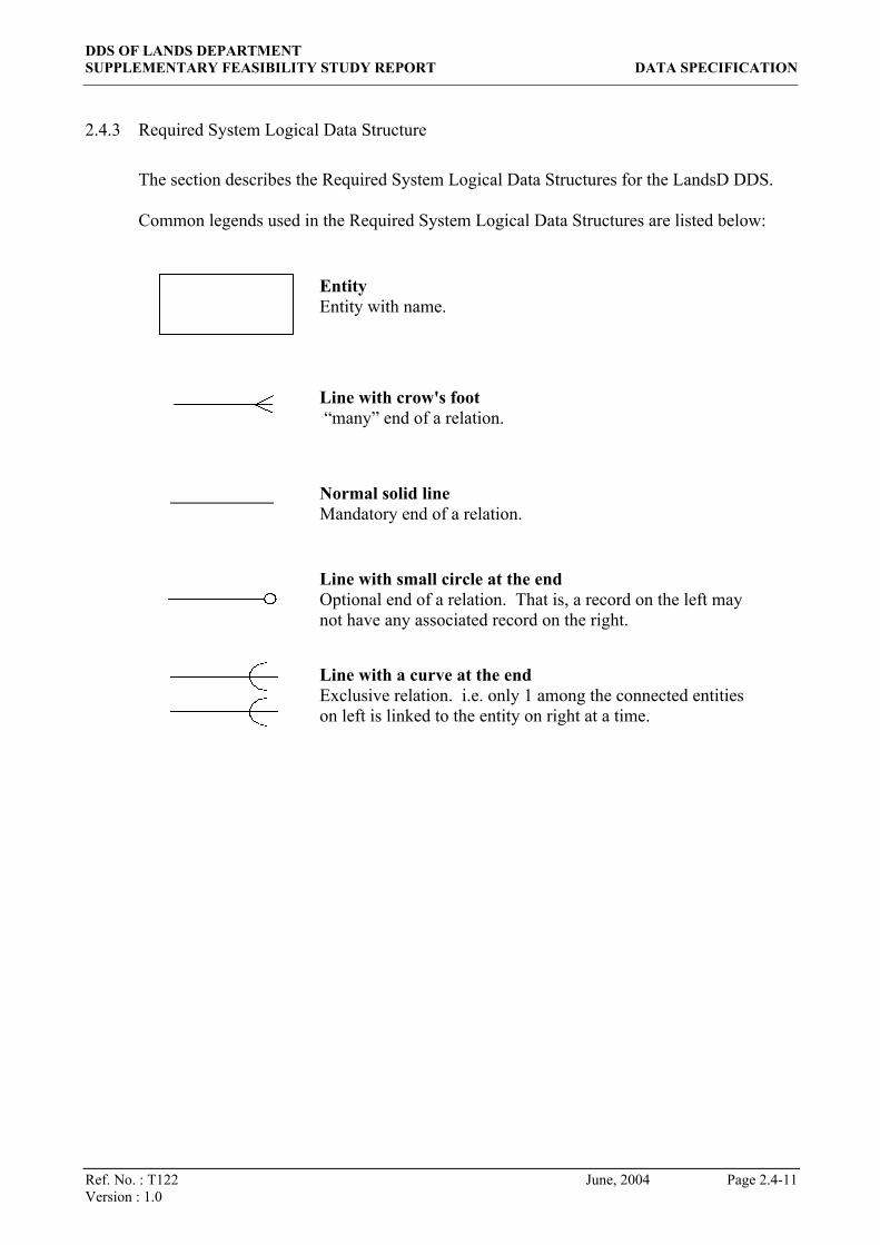
2.4.3 Required System Logical Data Structure
The section describes the Required System Logical Data Structures for the LandsD DDS. Common legends used in the Required System Logical Data Structures are listed below:
Entity Entity with name.
Line with crow's foot “many” end of a relation.
Normal solid line Mandatory end of a relation.
Line with small circle at the end Optional end of a relation. That is, a record on the left may not have any associated record on the right.
Line with a curve at the end Exclusive relation. i.e. only 1 among the connected entities on left is linked to the entity on right at a time.

DDS OF LANDS DEPARTMENT SUPPLEMENTARY FEASIBILITY STUDY REPORT DATA SPECIFICATION
Ref. No. : T122 Version : 1.0
Figure 2.4.3-1 Required System Logical Data Stru
B5000 in Arc/Info Native
B10000 in DGN
G1000 in Arc/Info Native
RG1000 in DWG
RG1000 in DXF
RG1000 in
RG1000 in DGN
RG1000 in E00
BG1000 in
SG1000 in E00
SG1000 in
SG1000 in DGN
SG1000 in DWG
SG1000
B1000 in Arc/Info Native
C1000 in Arc/Info Native
B1000 in e00
B1000 in ASCII
B1000 in DGN
B1000 in DWG
C1000 in e00
C1000 in
C1000 in DGN
C1000 in DWG
Order Detail
B1000 in DXF
C1000 in DXF
B5000 in e00
B5000 in
B5000 in DGN
B5000 in
B1000 in E00
B10000 in DGN
B10000 in DWG
B5000 in DXF
B10000 in DXF
B10000 in TIFF
B5000 in TIFF
B10000 in
Data Dictionaries
GeoCom
DOP10000 in TIFF
DOP5000 in TIFF
Digital Orthophoto
June, 2004 Page 2.4-12
cture – CLIS DDS
B20000 in DGN
in DXF
Undertaking Information
Customer Information
Licence and Contract Information
Customer Order Information
B20000 in e00
B20000 in
B20000 in DGN
B20000 in DWG
B20000 in DXF
B20000 in TIFF
Note: Please refers section 2.5.4 of Function Specification for the detail of the data conversion processes involved in the above entities of digital map data.
Digital data from other Gov. dept.
Code Tables
User Access Right Control
Transaction Log
Job Queue

DDS OF LANDS DEPARTMENT SUPPLEMENTARY FEASIBILITY STUDY REPORT DATA SPECIFICATION
Ref. No. : T122 June, 2004 Page 2.4-13 Version : 1.0
Figure 2.4.3-2 Required System Logical Data Structure – CSU DDS

DDS OF LANDS DEPARTMENT SUPPLEMENTARY FEASIBILITY STUDY REPORT DATA SPECIFICATION
Ref. No. : T122 June, 2004 Page 2.4-14 Version : 1.0
Figure 2.4.3-3 Required System Logical Data Structure –Building CSU

DDS OF LANDS DEPARTMENT SUPPLEMENTARY FEASIBILITY STUDY REPORT DATA SPECIFICATION
Ref. No. : T122 June, 2004 Page 2.4-15 Version : 1.0
Figure 2.4.3-4 Required System Logical Data Structure – Lot CSU

DDS OF LANDS DEPARTMENT SUPPLEMENTARY FEASIBILITY STUDY REPORT DATA SPECIFICATION
Ref. No. : T122 June, 2004 Page 2.4-16 Version : 1.0
Figure 2.4.3-5 Required System Logical Data Structure – Road Centreline CSU

DDS OF LANDS DEPARTMENT SUPPLEMENTARY FEASIBILITY STUDY REPORT DATA SPECIFICATION
Ref. No. : T122 June, 2004 Page 2.4-17 Version : 1.0
2.4.4 Required System Entity Description
The CSU DDS consists of 3 major databases. They are: Received CSU database which keeps the incoming data from LandsD or Data
Owners for updating the CSU spatial database in commonly file formats of E00, DGN or DWG4.
Centralized CSU database which keeps all CSU data in a centralised database. Extracted CSU database which keeps all CSU data in common used file formats of
E00, DGN and DWG for Data Users to download. Sections 2.4.4.1 and 2.4.4.2 mainly describe individual entities of the Building, Lot and Road Centreline CSU in the Centralized CSU database. Received CSU database and extracted CSU database consist corresponding CSU textual data in XML format or CSU spatial database in the DAM recommended file formats.
2.4.4.1 Entity Description (Part I – Volumetric for Each Entity (Year 1))
The following information for each entity would include:
• Entity name: Name of the entity • Description: Brief description of the entity • Entity occurrence: The minimum, average and maximum number of
occurrences of the entity • Volatility Period: Duration benchmarked for the calculation • Volatility: Detail breakdown on number of tiles deleted / inserted /
amended within volatility period • Annual Growth Rate: Estimation of the annual growth of the entity
[= (No. of Inserts – No. of Deletes) * 100%) / Avg. Occ.]
(The above formula does not apply to CLIS databases. Moreover, the annual growth rates applied in section 2.4.4.1.1 and 2.4.4.1.2 for CLIS data include annual tile growth rate, annual data content growth rate and annual data size growth rate)
4 Prior arrangement has been made between LandsD (Data Agent of Building CSU) and ArchSD so that ArchSD would submit Building CSU data under their jurisdiction in DWG format.

DDS OF LANDS DEPARTMENT SUPPLEMENTARY FEASIBILITY STUDY REPORT DATA SPECIFICATION
Ref. No. : T122 June, 2004 Page 2.4-18 Version : 1.0
2.4.4.1.1 Source Spatial Data Hub
This data hub will be used to store a copy of the digital map data extracted from the master set of current mapping libraries residing within CLIS.
Entity Name Description Min.
Occ. (tiles)
Avg. Occ. (tiles)
Max. Occ. (tiles)
Volatility Period
No. of Deletes (tiles)
No. of Inserts (tiles)
No. of Amend (tiles)
Annual Growth Rate %
B1000 in Arc/Info Native
B1000 in Arc/Info Native format stored in Source Spatial Data Hub
6,472 6,472 6,472 Yearly n/a n/a 2,317 30
B5000 in Arc/Info Native
B5000 in Arc/Info Native format stored in Source Spatial Data Hub
272 272 272 Yearly n/a n/a 189 25
B10000 in DGN B10000 in DGN format stored in Source Spatial Data Hub
62 62 62 Yearly n/a n/a 62 20
B20000 in DGN B20000 in DGN format stored in Source Spatial Data Hub
17 17 17 Yearly n/a n/a 16 20
C1000 in Arc/Info Native
C1000 in Arc/Info Native format stored in Source Spatial Data Hub
6,472 6,472 6,472 Yearly n/a n/a 2,496 20
Building Polygon in G1000 stored in Source Spatial Data Hub
6,472 6,472 6,472 Yearly n/a n/a 1,791 30
Road Centre Line in G1000 stored in Source Spatial Data Hub
6,472 6,472 6,472 Yearly n/a n/a 1,781 30
G1000 in Arc/Info Native
Site Polygon in G1000 stored in Source Spatial Data Hub
6,472 6,472 6,472 Yearly n/a n/a 593 30

DDS OF LANDS DEPARTMENT SUPPLEMENTARY FEASIBILITY STUDY REPORT DATA SPECIFICATION
Ref. No. : T122 June, 2004 Page 2.4-19 Version : 1.0
2.4.4.1.2 Multi-format Spatial Data Hub
This data hub will be used to store the digital map data extracted from the Source Spatial Data Hub (without restricted layers) and converted in various standard formats. Since every tiles in Source Spatial Data Hub will be converted into different data formats, the entity occurrence for each of the following subsections (i.e. i to vii) are same as section (A). Moreover, this data hub will also be used to store data dictionaries as well as digital data from other Government departments, which are described in the subsections viii and ix.
i. Digital map data in E00 format
Entity Name Description Min.
Occ. (tiles)
Avg. Occ. (tiles)
Max. Occ. (tiles)
Volatility Period
No. of Deletes (tiles)
No. of Inserts (tiles)
No. of Amend (tiles)
Annual Growth Rate %
B1000 in E00 B1000 in E00 format stored in Multi-format Spatial Data Hub
6,472 6,472 6,472 Yearly n/a n/a 2,317 30
B5000 in E00 B5000 in E00 format stored in Multi-format Spatial Data Hub
272 272 272 Yearly n/a n/a 189 25
B10000 in E00 B10000 in E00 format stored in Multi-format Spatial Data Hub
62 62 62 Yearly n/a n/a 62 20
B20000 in E00 B20000 in E00 format stored in Multi-format Spatial Data Hub
17 17 17 Yearly n/a n/a 16 20
C1000 in E00 C1000 in E00 format stored in Multi-format Spatial Data Hub
6,472 6,472 6,472 Yearly n/a n/a 2,547 20
RG1000 in E00 RG1000 in E00 format stored in Multi-format Spatial Data Hub
6,472 6,472 6,472 Yearly n/a n/a 1,814 30
SG1000 in E00 SG1000 in E00 format stored in Multi-format Spatial Data Hub
6,472 6,472 6,472 Yearly n/a n/a 1,057 30

DDS OF LANDS DEPARTMENT SUPPLEMENTARY FEASIBILITY STUDY REPORT DATA SPECIFICATION
Ref. No. : T122 June, 2004 Page 2.4-20 Version : 1.0
ii. Digital map data in ASCII format
Entity Name Description Min. Occ. (tiles)
Avg. Occ. (tiles)
Max. Occ. (tiles)
Volatility Period
No. of Deletes (tiles)
No. of Inserts (tiles)
No. of Amend (tiles)
Annual Growth Rate %
B1000 in ASCII B1000 in ASCII (ungenerate) format stored in Multi-format Spatial Data Hub
6,472 6,472 6,472 Yearly n/a n/a 2,317 30
B5000 in ASCII B5000 in ASCII (ungenerate) format stored in Multi-format Spatial Data Hub
272 272 272 Yearly n/a n/a 189 25
B10000 in ASCII
B10000 in ASCII (ungenerate) format stored in Multi-format Spatial Data Hub
62 62 62 Yearly n/a n/a 62 20
B20000 in ASCII
B20000 in ASCII (ungenerate) format stored in Multi-format Spatial Data Hub
17 17 17 Yearly n/a n/a 16 20
C1000 in ASCII C1000 in ASCII (ungenerate) format stored in Multi-format Spatial Data Hub
6,472 6,472 6,472 Yearly n/a n/a 2,547 20
BG1000 in ASCII
BG1000 in ASCII format stored in Multi-format Spatial Data Hub
6,472 6,472 6,472 Yearly n/a n/a 2,317 30
RG1000 in ASCII
RG1000 in ASCII format stored in Multi-format Spatial Data Hub
6,472 6,472 6,472 Yearly n/a n/a 1,814 30
SG1000 in ASCII
SG1000 in ASCII format stored in Multi-format Spatial Data Hub
6,472 6,472 6,472 Yearly n/a n/a 1,057 30
iii. Digital map data in DGN format
Entity Name Description Min.
Occ. (tiles)
Avg. Occ. (tiles)
Max. Occ. (tiles)
Volatility Period
No. of Deletes (tiles)
No. of Inserts (tiles)
No. of Amend (tiles)
Annual Growth Rate %
B1000 in DGN B1000 in DGN format stored in Multi-format Spatial Data Hub
6,472 6,472 6,472 Yearly n/a n/a 2,317 30
B5000 in DGN B5000 in DGN format stored in Multi-format Spatial Data Hub
272 272 272 Yearly n/a n/a 189 25
B10000 in DGN B10000 in DGN format stored in Multi-format Spatial Data Hub
62 62 62 Yearly n/a n/a 62 20
B20000 in DGN B20000 in DGN format stored in Multi-format Spatial Data Hub
17 17 17 Yearly n/a n/a 16 20

DDS OF LANDS DEPARTMENT SUPPLEMENTARY FEASIBILITY STUDY REPORT DATA SPECIFICATION
Ref. No. : T122 June, 2004 Page 2.4-21 Version : 1.0
Entity Name Description Min. Occ. (tiles)
Avg. Occ. (tiles)
Max. Occ. (tiles)
Volatility Period
No. of Deletes (tiles)
No. of Inserts (tiles)
No. of Amend (tiles)
Annual Growth Rate %
C1000 in DGN C1000 in DGN format stored in Multi-format Spatial Data Hub
6,472 6,472 6,472 Yearly n/a n/a 2,547 20
RG1000 in DGN
RG1000 in DGN format stored in Multi-format Spatial Data Hub
6,472 6,472 6,472 Yearly n/a n/a 1,814 30
SG1000 in DGN
SG1000 in DGN format stored in Multi-format Spatial Data Hub
6,472 6,472 6,472 Yearly n/a n/a 1,057 30
iv. Digital map data in DWG format
Entity Name Description Min.
Occ. (tiles)
Avg. Occ. (tiles)
Max. Occ. (tiles)
Volatility Period
No. of Deletes (tiles)
No. of Inserts (tiles)
No. of Amend (tiles)
Annual Growth Rate %
B1000 in DWG B1000 in DWG format stored in Multi-format Spatial Data Hub
6,472 6,472 6,472 Yearly n/a n/a 2,317 30
B5000 in DWG B5000 in DWG format stored in Multi-format Spatial Data Hub
272 272 272 Yearly n/a n/a 189 25
B10000 in DWG
B10000 in DWG format stored in Multi-format Spatial Data Hub
62 62 62 Yearly n/a n/a 62 20
B20000 in DWG
B20000 in DWG format stored in Multi-format Spatial Data Hub
17 17 17 Yearly n/a n/a 16 20
C1000 in DWG C1000 in DWG format stored in Multi-format Spatial Data Hub
6,472 6,472 6,472 Yearly n/a n/a 2,547 20
RG1000 in DWG
RG1000 in DWG format stored in Multi-format Spatial Data Hub
6,472 6,472 6,472 Yearly n/a n/a 1,814 30
SG1000 in DWG
SG1000 in DWG format stored in Multi-format Spatial Data Hub
6,472 6,472 6,472 Yearly n/a n/a 1,057 30

DDS OF LANDS DEPARTMENT SUPPLEMENTARY FEASIBILITY STUDY REPORT DATA SPECIFICATION
Ref. No. : T122 June, 2004 Page 2.4-22 Version : 1.0
v. Digital map data in DXF format
Entity Name Description Min. Occ. (tiles)
Avg. Occ. (tiles)
Max. Occ. (tiles)
Volatility Period
No. of Deletes (tiles)
No. of Inserts (tiles)
No. of Amend (tiles)
Annual Growth Rate %
B1000 in DXF B1000 in DXF format stored in Multi-format Spatial Data Hub
6,472 6,472 6,472 Yearly n/a n/a 2,317 30
B5000 in DXF B5000 in DXF format stored in Multi-format Spatial Data Hub
272 272 272 Yearly n/a n/a 189 25
B10000 in DXF B10000 in DXF format stored in Multi-format Spatial Data Hub
62 62 62 Yearly n/a n/a 62 20
B20000 in DXF B20000 in DXF format stored in Multi-format Spatial Data Hub
17 17 17 Yearly n/a n/a 16 20
C1000 in DXF C1000 in DXF format stored in Multi-format Spatial Data Hub
6,472 6,472 6,472 Yearly n/a n/a 2,547 20
RG1000 in DXF RG1000 in DXF format stored in Multi-format Spatial Data Hub
6,472 6,472 6,472 Yearly n/a n/a 1,814 30
SG1000 in DXF SG1000 in DXF format stored in Multi-format Spatial Data Hub
6,472 6,472 6,472 Yearly n/a n/a 1,057 30

DDS OF LANDS DEPARTMENT SUPPLEMENTARY FEASIBILITY STUDY REPORT DATA SPECIFICATION
Ref. No. : T122 June, 2004 Page 2.4-23 Version : 1.0
vi. Digital map data in TIFF format
Entity Name Description Min. Occ. (tiles)
Avg. Occ. (tiles)
Max. Occ. (tiles)
Volatility Period
No. of Deletes (tiles)
No. of Inserts (tiles)
No. of Amend (tiles)
Annual Growth Rate %
B5000 in TIFF B5000 in TIFF format stored in Multi-format Spatial Data Hub
272 272 272 Yearly n/a n/a 189 25
B10000 in TIFF B10000 in TIFF format stored in Multi-format Spatial Data Hub
62 62 62 Yearly n/a n/a 62 20
B20000 in TIFF B20000 in TIFF format stored in Multi-format Spatial Data Hub
17 17 17 Yearly n/a n/a 16 20
DOP5000 in TIFF *
DOP5000 in TIFF format stored in Multi-format Spatial Data Hub
189 189 189 Yearly n/a n/a 95 2
DOP10000 in TIFF
DOP10000 in TIFF format stored in Multi-format Spatial Data Hub
55 55 55 Yearly n/a n/a 28 2
Note: * DOP5000 data in ECW & MrSID formats are also included.
vii. GeoCommunity data in EXCEL format
Entity Name Description Min.
Occ. (files)
Avg. Occ. (files)
Max. Occ. (files)
Volatility Period
No. of Deletes (files)
No. of Inserts (files)
No. of Amend (files)
Annual Growth Rate %
GeoCom GeoCommunity data in EXCEL format
18 18 18 Yearly n/a n/a 9 2
viii. Data Dictionaries
Entity Name Description Min.
Occ. (copies)
Avg. Occ.
(copies)
Max. Occ.
(copies)
Volatility Period
No. of Deletes (copies)
No. of Inserts (copies)
No. of Amend ((copies)
Annual Growth Rate %
Data Dictionaries
Data dictionaries 20 20 20 Yearly 3 n/a n/a 10

DDS OF LANDS DEPARTMENT SUPPLEMENTARY FEASIBILITY STUDY REPORT DATA SPECIFICATION
Ref. No. : T122 June, 2004 Page 2.4-24 Version : 1.0
ix. Digital data from other Government departments
Entity Name Description Min. Occ. (tiles)
Avg. Occ. (tiles)
Max. Occ. (tiles)
Volatility Period
No. of Deletes (tiles)
No. of Inserts (tiles)
No. of Amend (tiles)
Annual Growth Rate %
Digital data from other Gov. dept.
Digital data provided from other Government departments which is disseminated from the proposed system
3,000 3,500 4,000 Yearly n/a n/a n/a 10
DDS OF LANDS DEPARTMENT SUPPLEMENTARY FEASIBILITY STUDY REPORT DATA SPECIFICATION
Ref. No. : T122 June, 2004 Page 2.4-25 Version : 1.0
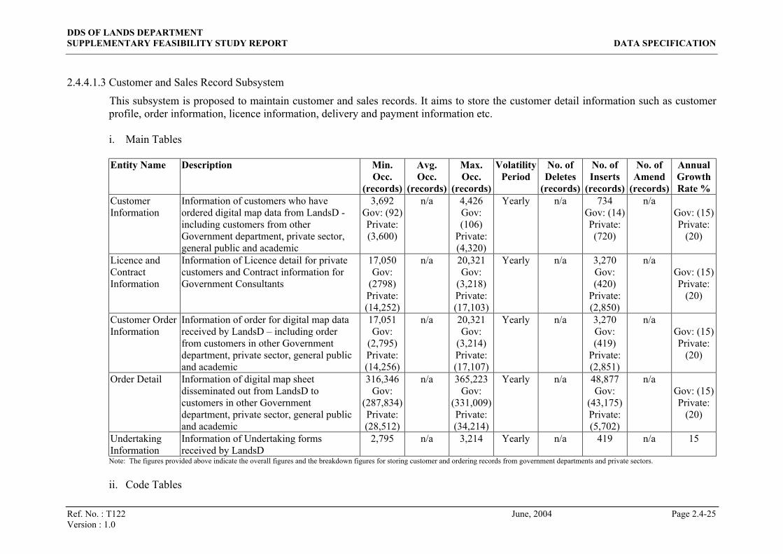
2.4.4.1.3 Customer and Sales Record Subsystem
This subsystem is proposed to maintain customer and sales records. It aims to store the customer detail information such as customer profile, order information, licence information, delivery and payment information etc. i. Main Tables
Entity Name Description Min.
Occ. (records)
Avg. Occ.
(records)
Max. Occ.
(records)
Volatility Period
No. of Deletes
(records)
No. of Inserts
(records)
No. of Amend
(records)
Annual Growth Rate %
Customer Information
Information of customers who have ordered digital map data from LandsD - including customers from other Government department, private sector, general public and academic
3,692 Gov: (92) Private: (3,600)
n/a 4,426 Gov: (106)
Private: (4,320)
Yearly n/a 734 Gov: (14) Private: (720)
n/a Gov: (15) Private:
(20)
Licence and Contract Information
Information of Licence detail for private customers and Contract information for Government Consultants
17,050 Gov:
(2798) Private: (14,252)
n/a 20,321 Gov:
(3,218) Private: (17,103)
Yearly n/a 3,270 Gov: (420)
Private: (2,850)
n/a Gov: (15) Private:
(20)
Customer Order Information
Information of order for digital map data received by LandsD – including order from customers in other Government department, private sector, general public and academic
17,051 Gov:
(2,795) Private: (14,256)
n/a 20,321 Gov:
(3,214) Private: (17,107)
Yearly n/a 3,270 Gov: (419)
Private: (2,851)
n/a Gov: (15) Private:
(20)
Order Detail Information of digital map sheet disseminated out from LandsD to customers in other Government department, private sector, general public and academic
316,346 Gov:
(287,834) Private: (28,512)
n/a 365,223 Gov:
(331,009) Private: (34,214)
Yearly n/a 48,877 Gov:
(43,175) Private: (5,702)
n/a Gov: (15) Private:
(20)
Undertaking Information
Information of Undertaking forms received by LandsD
2,795 n/a 3,214
Yearly n/a 419
n/a 15
Note: The figures provided above indicate the overall figures and the breakdown figures for storing customer and ordering records from government departments and private sectors.
ii. Code Tables

DDS OF LANDS DEPARTMENT SUPPLEMENTARY FEASIBILITY STUDY REPORT DATA SPECIFICATION
Ref. No. : T122 June, 2004 Page 2.4-26 Version : 1.0
Entity Name Description Min.
Occ. (records)
Avg. Occ.
(records)
Max. Occ.
(records)
Volatility Period
No. of Deletes
(records)
No. of Inserts
(records)
No. of Amend
(records)
Annual Growth Rate %
Code Tables The code and relevant information for supporting DDS application
612 n/a 624 Yearly n/a 12 n/a 2
iii. User Access Right Control Table
Entity Name Description Min.
Occ. (records)
Avg. Occ.
(records)
Max. Occ.
(records
Volatility Period
No. of Deletes
(records)
No. of Inserts
(records)
No. of Amend
(records)
Annual Growth Rate %
User Access Right Control Table
Information of user access right of the DDS – including customers and the system administrators
1,224
n/a 1,248
Yearly n/a 24
n/a 2
iv. Job Queue
Entity Name Description Min.
Occ. (records)
Avg. Occ.
(records)
Max. Occ.
(records
Volatility Period
No. of Deletes
(records)
No. of Inserts
(records)
No. of Amend
(records)
Annual Growth Rate %
Job Queue Information of queuing job for processing 2,600 Gov: (434)
Private: (2,166)
n/a 3,098 Gov: (499)
Private: (2,599)
Yearly n/a 498 Gov: (65) Private: (433)
n/a Gov: (15) Private:
(20)
Note: The figures provided above indicate the overall figures and the breakdown figures for storing job queue records from government departments and private sectors.

DDS OF LANDS DEPARTMENT SUPPLEMENTARY FEASIBILITY STUDY REPORT DATA SPECIFICATION
Ref. No. : T122 June, 2004 Page 2.4-27 Version : 1.0
v. Transaction Log
Entity Name Description Min. Occ.
(records)
Avg. Occ.
(records)
Max. Occ.
(records
Volatility Period
No. of Deletes
(records)
No. of Inserts
(records)
No. of Amend
(records)
Annual Growth Rate %
Transaction Log Transaction information of the proposed system
4,149 Gov: (577)
Private: (3,571)
n/a 4,949 Gov: (664)
Private: (4,285)
Yearly n/a 801 Gov: (87) Private: (714)
n/a Gov: (15) Private:
(20)
Note: The figures provided above indicate the overall figures and the breakdown figures for storing transaction records from government departments and private sectors.

DDS OF LANDS DEPARTMENT SUPPLEMENTARY FEASIBILITY STUDY REPORT DATA SPECIFICATION
Ref. No. : T122 June, 2004 Page 2.4-28 Version : 1.0
2.4.4.1.4 CSU Entities
2.4.4.1.4.1 Building CSU Entities
This specifies the relevant entries related to the Building CSU within the centralised database repository of CSU DDS.
Entity Name Description Min. Occ. (records)
Avg. Occ. (records)
Max. Occ.
(records)
Volatility Period
No. of Deletes
(records)
No. of Inserts
(records)
No. of Amend
(records)
Annual Growth Rate %
Building Geographical Info
Textual geographical information of a Building CSU 207,243 208,554 209,865 Yearly 0 12,704 18,450 6
Proposed Tower Polygon
Spatial feature representing the boundary of a proposed tower Building CSU
4,800 6,000 7,200 Yearly 6,000 6,000 12,000 0
Proposed Podium Polygon
Spatial feature representing the boundary of a proposed podium Building CSU
120 150 180 Yearly 150 150 300 0
Active Tower Polygon
Spatial feature representing the boundary of an active tower Building CSU
200,000 200,000 200,000 Yearly 400 6,000 6,000 3
Active Podium Polygon
Spatial feature representing the boundary of an active podium Building polygons
2,000 2,000 2,000 Yearly 4 150 150 7
Demolished Tower Polygon
Spatial feature representing the boundary of a demolished tower Building
320 400 480 Yearly 0 400 0 100

DDS OF LANDS DEPARTMENT SUPPLEMENTARY FEASIBILITY STUDY REPORT DATA SPECIFICATION
Ref. No. : T122 June, 2004 Page 2.4-29 Version : 1.0
Entity Name Description Min. Occ. (records)
Avg. Occ. (records)
Max. Occ.
(records)
Volatility Period
No. of Deletes
(records)
No. of Inserts
(records)
No. of Amend
(records)
Annual Growth Rate %
Demolished Podium Polygon
Spatial feature representing the boundary of a demolished podium Building CSU
3 4 5 Yearly 0 4 0 100
Building Structural Info
Textual structural information of a Building CSU
207,243 208,554 209,865 Yearly 2,086 6,257 12,513 2
Geo-Struct Mapping
Mapping between concerned Building Geographical Info and Building Structural Info records of a Building CSU
208,554 227,968 248,692 Yearly 456 6,839 13,678 3
Building OP Info
OP(s) related to a building. This entity is applicable for buildings under Category 1 only
42,000 42,000 42,000 Yearly 0 1,260 1,260 3
OP Info Information of Occupation Permits (OP). This entity is applicable for buildings under Category 1 only.
14,000 21,000 42,000 Yearly 0 630 630 3
Building Lot No In OP
Lot Number as marked in OP 42,000 42,000 42,000 Yearly 0 1,260 1,260 3
Development Name
Names of developments/estates 6,217 6,257 6,296 Yearly 0 381 369 6
Building Development Name
Links between buildings and their corresponding development names 207,243 208,554 209,865 Yearly 0 12,704 18,450 6

DDS OF LANDS DEPARTMENT SUPPLEMENTARY FEASIBILITY STUDY REPORT DATA SPECIFICATION
Ref. No. : T122 June, 2004 Page 2.4-30 Version : 1.0
Entity Name Description Min. Occ. (records)
Avg. Occ. (records)
Max. Occ.
(records)
Volatility Period
No. of Deletes
(records)
No. of Inserts
(records)
No. of Amend
(records)
Annual Growth Rate %
Building Name Name of buildings 207,243 208,554 209,865 Yearly 0 12,704 18,450 6
Building Address
Addresses of a Building CSU 208,554 312,831 417,108 Yearly 0 12,704 18,450 6
Street Location
Combination of street name and at most 3 location names that can be used in addresses
4,000 8,000 12,000 Yearly 20 240 100 3
Street Name List of street names 4,000 4,000 4,000 Yearly 20 120 40 3
Location Name List of location names 160 200 240 Yearly 1 6 2 3
Data Provision Date
The date when any attribute, regardless spatial or textual, of a Building CSU is last updated by Data Owners.
208,554 312,831 417,108 Yearly 0 9,385 0 3
Participating Department
List of Data Owner PDs. This is to be maintained by the Data Agent
5 6 7 Yearly 1 1 1 0
Renamed CSU
The history log for tracing purpose when a CSU is changed from Proposed status to Active status
4,920 6,150 7,380 Yearly 0 6,150 0 100

DDS OF LANDS DEPARTMENT SUPPLEMENTARY FEASIBILITY STUDY REPORT DATA SPECIFICATION
Ref. No. : T122 June, 2004 Page 2.4-31 Version : 1.0
2.4.4.1.4.2 Lot CSU Entities
This specifies the relevant entries related to the Lot CSU within the centralised database repository of CSU DDS.
Entity Name Description Min. Occ. (records)
Avg. Occ. (records)
Max. Occ. (records)
Volatility Period
No. of Deletes
(records)
No. of Inserts
(records)
No. of Amend
(records)
Annual Growth Rate %
Land Info Information of lots that mainly relates to the land administration
365,000 365,000 365,000 Yearly 365 3,650 18,250 1
Cert of Compliance Date
Date(s) of Certificate(s) of Compliance issued for each lot 43,800 54,750 65,700 Yearly 0 1,643 548 3
Resumption Notice
Information of resumption notices 365 730 1,095 Yearly 0 7 7 1
Land Resumption Notice
Relation between resumption notices and the affected lots 8,760 10,950 13,140 Yearly 0 110 110 1
Lot Type Name Lookup table for Lot Type Codes 880 1,100 1,320 Yearly 1 1 1 0
Lot Type District
Lookup table for District Codes 10 13 15 Yearly 1 1 1 0
Land Classification
Lookup table for Class Codes (i.e. types of grants)
63 79 95 Yearly 1 1 1 0
Area Unit Lookup table for Site Area Codes 4 5 6 Yearly 1 1 1 0

DDS OF LANDS DEPARTMENT SUPPLEMENTARY FEASIBILITY STUDY REPORT DATA SPECIFICATION
Ref. No. : T122 June, 2004 Page 2.4-32 Version : 1.0
Entity Name Description Min. Occ. (records)
Avg. Occ. (records)
Max. Occ. (records)
Volatility Period
No. of Deletes
(records)
No. of Inserts
(records)
No. of Amend
(records)
Annual Growth Rate %
Land Ownership
Lookup table for Land Ownership Codes, which are mostly for Government Land Allocation
10 55 100 Yearly 1 1 1 0
Lease Condition Type
Lookup table for Lease Condition Types
8 10 12 Yearly 1 1 1 0
Lease Use Lookup table for Lease Use Codes 100 550 1,000 Yearly 1 1 1 0
Lot Polygon Lot boundaries of active lots 361,350 361,350 361,350 Yearly 0 7,227 7,227 2
Overlap Lot Polygon
Active lot boundaries that are overlapping with other neighbouring lots
3,650 3,650 3,650 Yearly 0 73 73 2
Lot Register Lot registers maintained by LR 533,093 533,093 533,093 Yearly 0 10,662 10,662 2
Lot Register Lot Type
Lookup table for Lot Type Codes adopted by Lot Registers from LR
2,665 5,331 10,662 Yearly 5 11 11 0
Lot Register Area
Lookup table for Area Codes adopted by Lot Registers from LR
11 14 17 Yearly 1 1 1 0
Memorial Memorials registered at LR (only related to lot registers are covered)
1,224,343 1,224,343 1,224,343 Yearly 0 42,402 12,243 3
Lot Register Memorial
List of memorials that involved with a Lot Register
1,224,343 2,448,686 3,673,029 Yearly 0 84,804 24,487 3

DDS OF LANDS DEPARTMENT SUPPLEMENTARY FEASIBILITY STUDY REPORT DATA SPECIFICATION
Ref. No. : T122 June, 2004 Page 2.4-33 Version : 1.0
Entity Name Description Min. Occ. (records)
Avg. Occ. (records)
Max. Occ. (records)
Volatility Period
No. of Deletes
(records)
No. of Inserts
(records)
No. of Amend
(records)
Annual Growth Rate %
Memorial Nature
Lookup table for nature categorizations of memorials
200 250 300 Yearly 3 3 3 0
Subdivision History of lot subdivision registered by LR
42,402 46,642 50,882 Yearly 0 42,402 933 91

DDS OF LANDS DEPARTMENT SUPPLEMENTARY FEASIBILITY STUDY REPORT DATA SPECIFICATION
Ref. No. : T122 June, 2004 Page 2.4-34 Version : 1.0
2.4.4.1.4.3 Road Centreline CSU Entities
This specifies the relevant entries related to the Road Centreline CSU within the centralised database repository of CSU DDS.
Entity Name Description Min. Occ. (records)
Avg. Occ. (records)
Max. Occ.
(records)
Volatility Period
No. of Deletes
(records)
No. of Inserts
(records)
No. of Amend
(records)
Annual Growth Rate %
Road Segment Layer
This contains information relating linear features representing the active road network
12,000 24,000 204,000 Yearly 48 480 240 2
Road Intersection Layer
This contains information relating node features representing the active road intersections
24,000 30,000 36,000 Yearly 60 600 300 2
Road Intersection
This contains information about the street codes at a road intersection
8,000 20,000 200,000 Yearly 40 400 200 2
Road Name
This contains information about the street name of Road Centreline
4,000 4,000 4,000 Yearly 8 80 40 2

DDS OF LANDS DEPARTMENT SUPPLEMENTARY FEASIBILITY STUDY REPORT DATA SPECIFICATION
Ref. No. : T122 June, 2004 Page 2.4-35 Version : 1.0
2.4.4.1.4.4 System and Code Entities
Besides the core CSU entities, there are also some system and code tables entities kept in the centralised database repository of CSU DDS.
Entity Name Description Min. Occ.
(records) Avg. Occ. (records)
Max. Occ.
(records)
Volatility Period
No. of Deletes
(records)
No. of Inserts
(records)
No. of Amend
(records)
Annual Growth Rate %
Task and Schedule Table
The scheduled information to extract CSU data to conform to different file format standards
160 320 640 Yearly 320 320 0 2
Code Tables The code and relevant information for supporting CSU DDS application 200 300 500 Yearly 10 10 20 2
User Access Right Control Table
Information of user access right of the CSU DDS, including DA, DO & DU
25 50 100 Yearly 2 2 4 2
Job Queue Information of queuing job for processing 100 200 400 Yearly 200 200 0 2
Transaction Log Transaction information of the proposed system 400,000 475,000 550,000 Yearly 0 475,000 0 2

DDS OF LANDS DEPARTMENT SUPPLEMENTARY FEASIBILITY STUDY REPORT DATA SPECIFICATION
Ref. No. : T122 June, 2004 Page 2.4-36 Version : 1.0
2.4.4.2 Entity Description (Part II –Data Item Description)
The following describes the convention on the Formats used in the Entity Description:
(a) X(n) : Variable-length character strings of max. length n.
(b) CX(n): Variable-length character strings of maximum n Chinese characters. Maximum number of bytes will depend on the character set used by the CSU dataset. E.g. CX(5) occupies at most 10 bytes if data are stored in Big5 character set.
(c) N(m,n) : Fixed and floating point numbers, where m is precision (total number of digits before and after decimal point) and n is scale (number of digits to the right of decimal point). The n part is omitted, i.e. denoted in N(m), for integers.
(d) Date : Point-in-time values (date and time).
(e) Line : Types of line format.
(f) Node : Type of node format.
(g) Polygon : Type of polygon format.

DDS OF LANDS DEPARTMENT SUPPLEMENTARY FEASIBILITY STUDY REPORT DATA SPECIFICATION
Ref. No. : T122 June, 2004 Page 2.4-37 Version : 1.0
2.4.4.2.1 Entities in the Source Spatial Data Hub
The digital map data stored in this Hub is actually extracted from the master set of digital map data residing within CLIS. Since the extracted digital map data is exactly the same as the corresponding digital map data stored in CLIS, the entity description of a digital map data can be directly referred to the data dictionary of the corresponding digital map data in CLIS. The following data dictionaries are referred:
Entities in the Source Spatial Data Hub
Referred Data Dictionaries*
B1000 in Arc/Info Native Basic Mapping System Data Dictionary Version 2.1 May 2002 B5000 in Arc/Info Native B5000 Mapping System Data Dictionary Version 2.0 March
2001 B10000 in DGN B10000 Mapping Dataset in DGN format Data Dictionary
Version 2.02 September 2002 B20000 in DGN B20000 Mapping Dataset in DGN format Data Dictionary
Version 2.02 September 2002 C1000 in Arc/Info Native Cadastral Information System Data Dictionary Version 2.1 May
2002 G1000 in Arc/Info Native Basic Mapping System Data Dictionary Version 2.1 May 2002**
* The names and versions of the data dictionaries are subjected to change with the updated version of corresponding documents in LandsD.
.

DDS OF LANDS DEPARTMENT SUPPLEMENTARY FEASIBILITY STUDY REPORT DATA SPECIFICATION
Ref. No. : T122 June, 2004 Page 2.4-38 Version : 1.0
2.4.4.2.2 Entities in Multi-format Spatial Data Hub
The digital map data stored in this Hub is extracted from the Source Spatial Data Hub (except the restricted layers) and converted to the following formats:
E00 ASCII DGN DWG DXF TIFF EXCEL
The entity description for each format of the digital map data stored in this Hub are stated as follows:
i. Digital map data in E00 format
The content of the digital map data in this group is same as the current digital map data disseminated by LandsD in E00 format. The following data dictionaries in sales version are used as direct references for the entity description:
Entity Name Referred Data Dictionaries* B1000 in E00 1:1000 Basic Mapping System Data Dictionary (Data Sale Version -
Arc/Info Export Format) Version 2.1 June 2002 B5000 in E00 B5000 Mapping System Data Dictionary in ArcInfo format Version
2.0 March 2001 B10000 in E00 B10000 Mapping Dataset in ArcInfo Format Data Dictionary
Version 2.02 September 2002 B20000 in E00 B20000 Mapping Dataset in ArcInfo Format Data Dictionary
Version 2.02 September 2002 C1000 in E00 C1000 1:1000 Digital Land Boundary Map Database Data Dictionary
(Data Sale Version - Arc/Info Format) Version 2.1 June 2002 RG1000 in E00 SG1000 in E00
The reference data dictionaries will be provided once they are available from LandsD
* The names and versions of the data dictionaries are subjected to change with the updated version of corresponding documents in LandsD.
ii. Digital map data in ASCII format
The content of the digital map data in this group is same as the current digital map data disseminated by LandsD in ASCII format. For the following digital map data:
• B1000 • B5000 • B10000 • B20000 • C1000

DDS OF LANDS DEPARTMENT SUPPLEMENTARY FEASIBILITY STUDY REPORT DATA SPECIFICATION
Ref. No. : T122 June, 2004 Page 2.4-39 Version : 1.0
the data dictionaries are not currently available in ASCII format. It is suggested to refer to the data dictionaries in Arc/Info format (sales version) for the entity description as the digital map data in ASCII format is generated from Arc/Info using internal command of Arc/Info. For G1000 digital map data, a fact sheet is used as a direct reference for the entity description in ASCII format (please refer to Appendix 3.2.9 for the fact sheet). The following data dictionaries and document are referred:
Entity Name Referred Data Dictionaries and Document* B1000 in ASCII 1:1000 Basic Mapping System Data Dictionary (Data Sale Version
- Arc/Info Export Format) Version 2.1 June 2002 B5000 in ASCII B5000 Mapping System Data Dictionary in ArcInfo format Version
2.0 March 2001 B10000 in ASCII B10000 Mapping Dataset in ArcInfo Format Data Dictionary
Version 2.02 September 2002 B20000 in ASCII B20000 Mapping Dataset in ArcInfo Format Data Dictionary
Version 2.02 September 2002 C1000 in ASCII C1000 1:1000 Digital Land Boundary Map Database Data
Dictionary (Data Sale Version - Arc/Info Format) Version 2.1 June 2002
BG1000 in ASCII RG1000 in ASCII SG1000 in ASCII
“Geo-Reference Database (G1000)” – fact sheet of LandsD published on April 2003
* The names and versions of the referred data dictionaries and document are subjected to change with the updated version of corresponding documents in LandsD.
iii. Digital map data in DGN format
The data content of the digital map data in this group is same as the current digital map data disseminated by LandsD in DGN format. The following data dictionaries in sales version are used as a direct reference for the entity description:
Entity Name Referred Data Dictionaries * B1000 in DGN B1000 1:1000 Digital Topographic Map Database Data Dictionary
for DGN Format Version 2.1 June 2002 B5000 in DGN B5000 1:5000 Digital Topographic Map Database Data Dictionary
for DGN Format Version 2.0 June 2001 B10000 in DGN B10000 Mapping Dataset in DGN format Data Dictionary Version
2.02 September 2002 B20000 in DGN B20000 Mapping Dataset in DGN format Data Dictionary Version
2.02 September 2002 C1000 in DGN C1000 1:1000 Digital Land Boundary Map Database Data
Dictionary for DGN Format Version 2.1 June 2002 RG1000 in DGN SG1000 in DGN
The reference data dictionaries will be provided once they are available from LandsD
* The names and versions of the data dictionaries are subjected to change with the updated version of corresponding documents in LandsD.
iv. Digital map data in DWG/DXF format

DDS OF LANDS DEPARTMENT SUPPLEMENTARY FEASIBILITY STUDY REPORT DATA SPECIFICATION
Ref. No. : T122 June, 2004 Page 2.4-40 Version : 1.0
The data content of the digital map data in this group is same as the current digital map data disseminated by LandsD in DWG/DXF format. The following data dictionaries in sales version are used as direct references for the entity description.
Entity Name Referred Data Dictionaries* B1000 in DWG/ DXF
B1000 1:1000 Digital Topographic Map Database Data Dictionary for DWG/DXF Format Version 2.1 June 2002
B5000 in DWG/ DXF
B5000 1:5000 Digital Topographic Map Database Data Dictionary for DWG/DXF Format Version 2.0 June 2001
B10000 in DWG/ DXF
B10000 Mapping Dataset in DWG/DXF format Data Dictionary Version 2.02 September 2002
B20000 in DWG/ DXF
B20000 Mapping Dataset in DWG/DXF format Data Dictionary Version 2.02 September 2002
C1000 in DWG/ DXF
C1000 1:1000 Digital Land Boundary Map Database Data Dictionary for DWG/DXF Format Version 2.1 June 2002
RG1000 in DWG/DXF SG1000 in DWG/DXF
The reference data dictionaries will be provided once they are available from LandsD
* The names and versions of the data dictionaries are subjected to change with the updated version of corresponding documents in LandsD
v. Digital map data in TIFF format
The digital map data in this group is in a raster format (i.e. image file). The reference for the entity description of this group will be based on the relevant data dictionaries in LandsD once they are available.
vi. GeoCommunity Database (GeoCom) in EXCEL format
GeoCom is a set of geo-coded community information embedded with spatial reference in textual database EXCEL format. The reference for the entity description of this group will be based on the relevant data dictionaries in LandsD once they are available.
vii. Data dictionaries for the LandsD digital map data
The entity description of the data dictionaries for the LandsD digital map data is not applicable as those dictionaries are proposed to be stored as document files format (e.g. Acrobat format).
viii. Digital data from other Government departments
The entity description of the digital data from other Government departments is not applicable as LandsD should be only responsible for providing the digital data from other Government departments to users upon receipt of request and should not be responsible for the maintenance and updating of the data.

DDS OF LANDS DEPARTMENT SUPPLEMENTARY FEASIBILITY STUDY REPORT DATA SPECIFICATION
Ref. No. : T122 June, 2004 Page 2.4-41 Version : 1.0
2.4.4.2.3 Entities in Customer and Sales Record Subsystem
Customer and Sales Record Subsystem is developed for the proposed dissemination system to store information on the particulars of customers, order records, total cost of each order and other related information for digital map data dissemination. Apart form this, various code tables are required to support the system. However, the detail structure and number of code tables can be decided during system design phase.
The major entities for this subsystem are tabulated below (the number of entities and attributes of each entity will be finalised in the System Analysis and Design (SA&D) stage) i. Customer Information
Entity Data Item Description & Validation Format Mandatory Key
Customer ID A unique identification number assigned to each customer X(10) Y Y Customer Type Code A code assigned to identify the customer type (e.g. public,
Government consultant) X(5) Y N
Department Code A code assigned to identify the department (for Government only) of the customer
X(5) N N
Company Company name X(20) N N Job Title Job title of the customer X(20) N N Customer Name Customer name X(20) Y N Address 1 Line 1 of the customer mailing address X(50) N N Address 2 Line 2 of the customer mailing address X(50) N N Address 3 Line 3 of the customer mailing address X(50) N N Telephone Number Telephone number of the customer N(10) N N Fax Number Fax number of the customer N(10) N N Email Address Email address of the customer X(30) N N Login Name Login name for the customer to login the system X(10) N N
Customer Information
Login Password Login password for the customer to login the system X(10) N N
ii. Licence and Contract Information

DDS OF LANDS DEPARTMENT SUPPLEMENTARY FEASIBILITY STUDY REPORT DATA SPECIFICATION
Ref. No. : T122 June, 2004 Page 2.4-42 Version : 1.0
Entity Data Item Description & Validation Format Mandatory Key Licence/Contract ID An unique identification number assigned to the licence
issued or the unique identification number assigned to the contract
X(10) Y Y
Code for Intended use of the digital map data
A code assigned to identify the customer intention in using the ordered digital map data
X(5) N N
Code for Hardware and Software Configuration
A code assigned to identify the computer configuration of the customer for using the ordered digital map data
X(10) N N
Terminal Type Type of terminal X(10) N N Serial No. Terminal serial no. X(10) N N Location Terminal location X(20) N N Expiry date Licence / Contract expiry date Date N N Cessation Date Contract cessation date for Government consultants Date N N Customer Id Customer identification number X(10) N N
Licence and Contract Information
Remarks Remarks X(80) N N
iii. Customer Order Information
Entity Data Item Description & Validation Format Mandatory Key Customer ID A unique identification number assigned to the customer X(10) Y N Undertaking ID An unique identification number assigned to Undertaking
form received X(10) Y N
Licence/ Contract ID An unique identification number assigned to the licence issued or the unique identification number assigned to Contract
X(10) Y N
Order ID A unique identification number assigned for the order made by the customer each time
X(10) Y Y
Demand Note ID A unique identification number assigned for the demand note issued to the customer
X(10) N N
Issue date Demand note issue date Date N N Due Date Payment Due Date Date N N Print Flag A flag indicating whether Demand note has already been
printed or not X(1) N N
Customer Order Information
Status Code A flag indicating the status of demand note X(1) N N

DDS OF LANDS DEPARTMENT SUPPLEMENTARY FEASIBILITY STUDY REPORT DATA SPECIFICATION
Ref. No. : T122 June, 2004 Page 2.4-43 Version : 1.0
Entity Data Item Description & Validation Format Mandatory Key Code for Payment Method
Code identify the payment method for the order X(5) N N
Code For Dispatch Method
Code identify the dispatch method requested by the customer X(5) N N
Order Date Order date for the digital map data Date N N Order Completion Date The completion date of the order Date N N
Total Cost for the Order The total cost for the order N(10) N N
iv. Order Detail
Entity Data Item Description & Validation Format Mandatory Key Order ID A unique identification number assigned for the order made
by the customer each time X(10) Y Y
Code for Product Category
The code assigned to identify the category of the map product, e.g. Digital Topographic Map Database, Data Dictionary etc.
X(10) Y Y
Code for Product Scale The code assigned to identify the scale of the map product X(5) Y Y Code for Product Name The code assigned to identify the sheet number of the digital
map data or the name of data dictionary ordered X(10) Y Y
Layer Name The digital map data layer ordered X(30) N N Code for Product Format
The code assigned to identify the data format of the ordered map data
X(5) Y Y
Pointer to Product Pointer to the file location of the product X(80) N N Quantity Quantity of each product ordered N(5) N N
Order Detail
Product Revision Date The revision date of the map sheet or the data dictionary Date N N v. Undertaking Information
Entity Data Item Description & Validation Format Mandatory Key
Customer ID Customer Identification Number X(10) Y Y Undertaking ID An unique identification number assigned to Undertaking
form received X(10) Y Y
Undertaking Information
Undertaking Date Date on which Undertaking form is filled up Date Y N

DDS OF LANDS DEPARTMENT SUPPLEMENTARY FEASIBILITY STUDY REPORT DATA SPECIFICATION
Ref. No. : T122 June, 2004 Page 2.4-44 Version : 1.0
Entity Data Item Description & Validation Format Mandatory Key Agreement No. Agreement number of the contract between the government
department and the government consultant X(10) Y N
Contract Expiry date Date on which contract expires Date Y N Government Dept Name of Government Department X(20) N N Responsible person Name of the responsible person for undertaking X(10) N N Designation Designation of the responsible person X(10) N N Section Section of the responsible person X(10) N N Tel_no Telephone No. of the responsible person X(10) N N
Fax_No Fax No. of the responsible person X(10) N N
vi. Code Tables
Entity Data Item Description & Validation Format Mandatory Key Table Flag A unique identifier to identify each code table X(10) Y Y Code 1 Code 1 required to support the DDS activities X(10) Y Y Code 2 Code 2 required to support the DDS activities X(10) Y Y Description for Code 1 Description for the code 1 X(50) N N
Code Tables
Description for Code 2 Description for the code 2 X(50) N N vii. User Access Right Control Table
Entity Data Item Description & Validation Format Mandatory Key
User/Customer ID A unique identification number assigned to the LandsD users or customers
X(10) Y Y
User/Customer Name Name of the LandsD users or customer X(20) Y N Group ID A unique identification number assigned to the group of
user/customer who have same access right to the system X(10) Y Y
Access Right Code The code represent the access right to the system X(10) Y N
User Access Right Control Table
Access Right Code Description
The description of the access right code X(50) N N
viii. Job Queue
DDS OF LANDS DEPARTMENT SUPPLEMENTARY FEASIBILITY STUDY REPORT DATA SPECIFICATION
Ref. No. : T122 June, 2004 Page 2.4-45 Version : 1.0
Entity Data Item Description & Validation Format Mandatory Key Job Number A unique identification number assigned to a job queuing for
processing X(10) Y Y
Order ID A unique identification number assigned for the order made by the customer each time
X(10) Y N
Creation Date Date of the job created Date N N Execution Date Date of the job executed Date N N Completion Date Date of the job completed Date N N Priority Priority of the job X(2) N N Status The status of the job X(5) N N
Job Queue
Remarks Remarks X(50) N N
ix. Transaction Log
Entity Data Item Description & Validation Format Mandatory Key Function ID A unique identification number assigned to the LandsD users
or customers X(10) Y Y
User/Customer ID A unique identification number assigned to the LandsD users or customers
X(10) Y Y
Transaction Date Date of transaction Date Y N Transaction Type Type of transaction X(10) N N Action Code Action code X(10) N N Before Image Image before the transaction X(80) N N
Transaction Log
After Image Image after the transaction X(80) N N

DDS OF LANDS DEPARTMENT SUPPLEMENTARY FEASIBILITY STUDY REPORT DATA SPECIFICATION
Ref. No. : T122 June, 2004 Page 2.4-46 Version : 1.0
2.4.4.2.4 CSU Entities
2.4.4.2.4.1 Building CSU Entities
Entity Data Item Description & Validation Format Mandatory Primary Key
Geo Ref No Geo-reference No. of the label point of the building polygon X(10) Y Y
Record Creation Date Date on which the building polygon is first created in CLIS of LandsD
Date Y Y
Polygon Type Type of the building polygon, where
T = Tower
P = Podium
X(1) Y Y
Concatenated ID Concatenation of Geo Ref No, Polygon Type and Record Creation Date (GGGGGGGGGGTYYYYMMDD), where
GGGGGGGGGG part = Geo Ref No
T part = Polygon Type
YYYYMMDD part = Record Creation Date formatted to string representation in YYYYMMDD date format
X(19) Y N
Record ID Computer-generated unique identifier N(9) Y N
Building Geographical Info
Status Record status, where
P = Proposed
A = Active
D = Demolished
X(1) Y N

DDS OF LANDS DEPARTMENT SUPPLEMENTARY FEASIBILITY STUDY REPORT DATA SPECIFICATION
Ref. No. : T122 June, 2004 Page 2.4-47 Version : 1.0
Entity Data Item Description & Validation Format Mandatory Primary Key
Category Building category, where
1 = Legal private buildings and HA/HS buildings that require an occupation permit and are under enforcement of the Buildings Ordinance
2 = NT small houses
3 = HA buildings except PSPS buildings
4 = Other government buildings
5 = Miscellaneous structures
This information may not be available on record creation. However, once it is ever filled by the Data Owner, it must not be reverted to null value. In addition, warning should be given to original and new Data Owners in case Category is changed from a non-null value to another non-null value.
X(1) N N
Housing Scheme HA housing scheme
(Applicable for PSPS buildings under Category 1 and those under Category 3 only, Null for others)
X(10) N N
Cert of Exemption Date Building Works
Date on which Certificate of Exemption - Building Works is issued
(Applicable for Category 2 only, Null for others)
Date N N
Cert of Exemption Date Site Formation Works
Date on which Certificate of Exemption - Site Formation Works is issued
(Applicable for Category 2 only, Null for others)
Date N N

DDS OF LANDS DEPARTMENT SUPPLEMENTARY FEASIBILITY STUDY REPORT DATA SPECIFICATION
Ref. No. : T122 June, 2004 Page 2.4-48 Version : 1.0
Entity Data Item Description & Validation Format Mandatory Primary Key
Cert of Exemption Date Drainage Works
Date on which Certificate of Exemption - Drainage Works is issued
(Applicable for Category 2 only, Null for others)
Date N N
Demolition Completion Date
Completion date of demolition work, in particular,
Category 1: As reported by responsible AP/RSE.
Category 4: As recorded by ArchSD
Category 2, 3 & 5: Information not available and will be left as Null.
Date N N
Timestamp Date and time when the record is last created/modified (i.e. when new data value(s) from Data Owner(s) is imported into the CSU dataset)
Date Y N
Concatenated ID Concatenation of Geo Ref No, Polygon Type and Record Creation Date
X(19) Y Y
Geometry Geometry of building polygon Polygon Y N
Proposed Tower Polygon
Timestamp Date and time when the record is last created/modified (i.e. when new data value(s) from Data Owner(s) is imported into the CSU dataset)
Date Y N
Concatenated ID Concatenation of Geo Ref No, Polygon Type and Record Creation Date
X(19) Y Y Proposed Podium Polygon
Geometry Geometry of building polygon Polygon Y N

DDS OF LANDS DEPARTMENT SUPPLEMENTARY FEASIBILITY STUDY REPORT DATA SPECIFICATION
Ref. No. : T122 June, 2004 Page 2.4-49 Version : 1.0
Entity Data Item Description & Validation Format Mandatory Primary Key
Timestamp Date and time when the record is last created/modified (i.e. when new data value(s) from Data Owner(s) is imported into the CSU dataset)
Date Y N
Concatenated ID Concatenation of Geo Ref No, Polygon Type and Record Creation Date
X(19) Y Y
Geometry Geometry of building polygon Polygon Y N
Active Tower Polygon
Timestamp Date and time when the record is last created/modified (i.e. when new data value(s) from Data Owner(s) is imported into the CSU dataset)
Date Y N
Concatenated ID Concatenation of Geo Ref No, Polygon Type and Record Creation Date
X(19) Y Y
Geometry Geometry of building polygon Polygon Y N
Active Podium Polygon
Timestamp Date and time when the record is last created/modified (i.e. when new data value(s) from Data Owner(s) is imported into the CSU dataset)
Date Y N
Concatenated ID Concatenation of Geo Ref No, Polygon Type and Record Creation Date
X(19) Y Y
Geometry Geometry of building polygon Polygon Y N
Demolished Tower Polygon
Timestamp Date and time when the record is last created/modified (i.e. when new data value(s) from Data Owner(s) is imported into the CSU dataset)
Date Y N

DDS OF LANDS DEPARTMENT SUPPLEMENTARY FEASIBILITY STUDY REPORT DATA SPECIFICATION
Ref. No. : T122 June, 2004 Page 2.4-50 Version : 1.0
Entity Data Item Description & Validation Format Mandatory Primary Key
Concatenated ID Concatenation of Geo Ref No, Polygon Type and Record Creation Date
X(19) Y Y
Geometry Geometry of building polygon Polygon Y N
Demolished Podium Polygon
Timestamp Date and time when the record is last created/modified (i.e. when new data value(s) from Data Owner(s) is imported into the CSU dataset)
Date Y N
Category Building category X(1) Y Y
Structure ID Record identifier:
When Category = ‘1’, it references to the concerned Building Block ID as in BD’s BCIS;
For other categories, it references to Record ID of the concerned Building Geographical Info record.
N(9) Y Y
Building Structural Info
Storeys Above Podium Number of storeys above podium/basement for tower blocks. It is applicable only when BD Block Type = ‘TOW’ or ‘OTH’ for Category 1 buildings, or Polygon Type of corresponding Building Geographical Info = ‘T’ for other categories.
This figure counts only the over-podium part if the tower is sitting on a podium. For towers not sitting on podium, this counts the part over basement.
(Applicable for Category 1-4 only, Null for Category 5)
N(3) N N

DDS OF LANDS DEPARTMENT SUPPLEMENTARY FEASIBILITY STUDY REPORT DATA SPECIFICATION
Ref. No. : T122 June, 2004 Page 2.4-51 Version : 1.0
Entity Data Item Description & Validation Format Mandatory Primary Key
Storeys In Podium Number of storeys in podium and above basement. This means the number of above-basement storeys in the podium itself for podium blocks, and means number of above-basement storeys in the podium below for tower blocks.
This information may not be available for Category 1 & 4 buildings.
This data item is not applicable for Category 2 & 5 and will be left as Null.
N(2) N N
Storeys In Basement Number of storeys in basement/lower ground. This counts only the storeys covered by the concerned Building CSU. For example, the basement storeys are counted into the podium block only but not to the towers sitting above.
(Applicable for Category 1, 3 & 4 only, Null for Category 2 & 5)
N(2) N N
Storeys Remarks Textual description to clarify number of storeys of the building
(Applicable for Category 1 only, Null for others)
X(200) N N

DDS OF LANDS DEPARTMENT SUPPLEMENTARY FEASIBILITY STUDY REPORT DATA SPECIFICATION
Ref. No. : T122 June, 2004 Page 2.4-52 Version : 1.0
Entity Data Item Description & Validation Format Mandatory Primary Key
Completion Year Year in which the building is completed, in particular,
Category 1: The year in which the OP is issued for the building. For buildings covered by multiple OPs, the first full OP will be referenced.
Category 2: The year in which the Certificate of Compliance is issued for the building.
Category 3: Year of completion information as provided by HA.
Category 4: Year of completion as identified by ArchSD.
Category 5: Information not available and will be left as Null.
N(4) N N
DDS OF LANDS DEPARTMENT SUPPLEMENTARY FEASIBILITY STUDY REPORT DATA SPECIFICATION
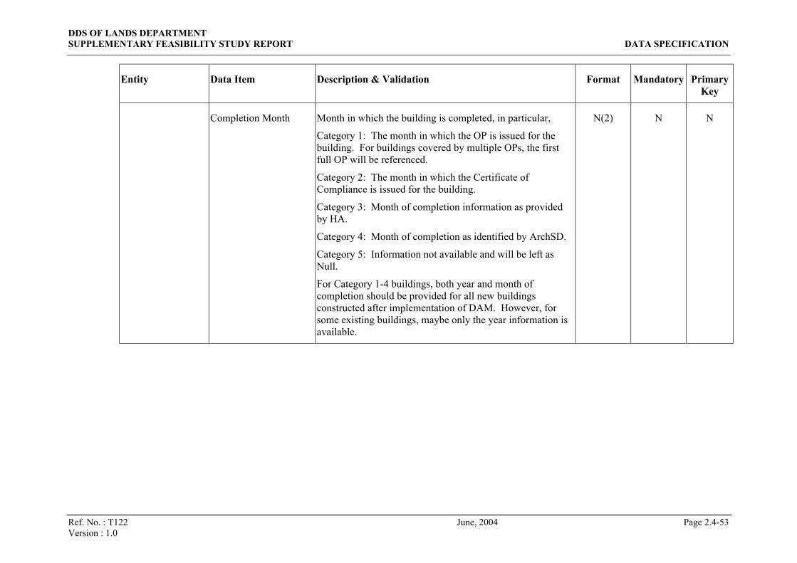
Ref. No. : T122 June, 2004 Page 2.4-53 Version : 1.0
Entity Data Item Description & Validation Format Mandatory Primary Key
Completion Month Month in which the building is completed, in particular,
Category 1: The month in which the OP is issued for the building. For buildings covered by multiple OPs, the first full OP will be referenced.
Category 2: The month in which the Certificate of Compliance is issued for the building.
Category 3: Month of completion information as provided by HA.
Category 4: Month of completion as identified by ArchSD.
Category 5: Information not available and will be left as Null.
For Category 1-4 buildings, both year and month of completion should be provided for all new buildings constructed after implementation of DAM. However, for some existing buildings, maybe only the year information is available.
N(2) N N

DDS OF LANDS DEPARTMENT SUPPLEMENTARY FEASIBILITY STUDY REPORT DATA SPECIFICATION
Ref. No. : T122 June, 2004 Page 2.4-54 Version : 1.0
Entity Data Item Description & Validation Format Mandatory Primary Key
Completion Day Day of the month (1-31) on which the building is completed, in particular,
Category 1: The day on which the OP is issued for the building. For buildings covered by multiple OPs, the first full OP will be referenced.
Category 2: The day on which the Certificate of Compliance is issued for the building.
Category 3: Day of completion information as provided by HA.
Category 4: Day of completion as identified by ArchSD.
Category 5: Information not available and will be left as Null.
For Category 1-4 buildings, the full completion date (with year, month and day) should be provided for all new buildings constructed after implementation of DAM as far as possible. However, for some buildings, maybe only the year information, or year/month, is available.
N(2) N N

DDS OF LANDS DEPARTMENT SUPPLEMENTARY FEASIBILITY STUDY REPORT DATA SPECIFICATION
Ref. No. : T122 June, 2004 Page 2.4-55 Version : 1.0
Entity Data Item Description & Validation Format Mandatory Primary Key
Approximate Building Top Level
Elevation of building above principal datum in metres, in particular,
Category 1 & 4: Top level of a building is measured to the mean height of the roof over the highest usable floor space in the building.
Category 2: Approximate level of the top of a building in metre above HKPD.
Category 3 & 5: Approximate level of the top of a building in metre above HKPD. Due to resource constraint and site constraint, LandsD does not have building height of every building in Hong Kong. Only partially available for buildings constructed before implementation of DAM and LandsD currently has no resource to collect this information regularly.
N(8,2) N N
GFA Gross floor area in M2
(Applicable for Category 1 only, Null for others)
N(10,2) N N
BD Block Type Building block type as recorded by BD, where
TOW = Tower
POD = Podium
OTH = Others
(Applicable for Category 1 only, Null for others)
X(3) N N
Building Type In OP Types of building as of OP e.g. industrial, commercial
(Applicable for Category 1 only, Null for others)
X(200) N N

DDS OF LANDS DEPARTMENT SUPPLEMENTARY FEASIBILITY STUDY REPORT DATA SPECIFICATION
Ref. No. : T122 June, 2004 Page 2.4-56 Version : 1.0
Entity Data Item Description & Validation Format Mandatory Primary Key
Timestamp Date and time when the record is last created/modified (i.e. when new data value(s) from Data Owner(s) is imported into the CSU dataset)
Date Y N
Geo Record ID Identifier of the concerned Building Geographical Info record
N(9) Y Y
Category Building category X(1) Y Y
Structure ID Identifier of the concerned Building Structural Info record. Hence, when Category <> ‘1’, it has the same value as Geo Record ID.
N(9) Y Y
Geo-Struct Mapping
Timestamp Date and time when the record is last created/modified (i.e. when new data value(s) from Data Owner(s) is imported into the CSU dataset). Hence, it also means when Category is identified for the Building CSU.
Date Y N
Category Building category. Hence, always ‘1’. X(1) Y Y
Structure ID Identifier of the concerned Building Structural Info record. Hence, it references to the concerned Building Block ID as in BD’s BCIS
N(9) Y Y
Building OP Info
OP No Occupation permit number e.g. ‘D141/55’ X(15) Y N
OP Info OP No Occupation permit number e.g. ‘D141/55’ X(15) Y Y
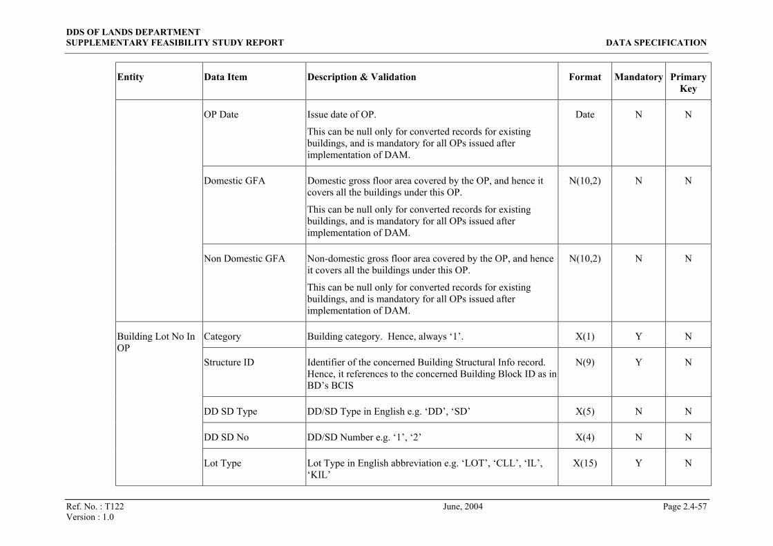
DDS OF LANDS DEPARTMENT SUPPLEMENTARY FEASIBILITY STUDY REPORT DATA SPECIFICATION
Ref. No. : T122 June, 2004 Page 2.4-57 Version : 1.0
Entity Data Item Description & Validation Format Mandatory Primary Key
OP Date Issue date of OP.
This can be null only for converted records for existing buildings, and is mandatory for all OPs issued after implementation of DAM.
Date N N
Domestic GFA Domestic gross floor area covered by the OP, and hence it covers all the buildings under this OP.
This can be null only for converted records for existing buildings, and is mandatory for all OPs issued after implementation of DAM.
N(10,2) N N
Non Domestic GFA Non-domestic gross floor area covered by the OP, and hence it covers all the buildings under this OP.
This can be null only for converted records for existing buildings, and is mandatory for all OPs issued after implementation of DAM.
N(10,2) N N
Category Building category. Hence, always ‘1’. X(1) Y N
Structure ID Identifier of the concerned Building Structural Info record. Hence, it references to the concerned Building Block ID as in BD’s BCIS
N(9) Y N
DD SD Type DD/SD Type in English e.g. ‘DD’, ‘SD’ X(5) N N
DD SD No DD/SD Number e.g. ‘1’, ‘2’ X(4) N N
Building Lot No In OP
Lot Type Lot Type in English abbreviation e.g. ‘LOT’, ‘CLL’, ‘IL’, ‘KIL’
X(15) Y N

DDS OF LANDS DEPARTMENT SUPPLEMENTARY FEASIBILITY STUDY REPORT DATA SPECIFICATION
Ref. No. : T122 June, 2004 Page 2.4-58 Version : 1.0
Entity Data Item Description & Validation Format Mandatory Primary Key
Lot No Lot Number (including both numeric and alphabetical part) e.g. ‘123’, ‘328’, ‘20A’
X(13) Y N
Section 1 The first section letter (e.g. ‘A’, ‘B’, ‘AA’, ‘C-F’) appeared in a lot designation.
Special values for non-section letters are enclosed in brackets, where:
(PE) = PRAYA EXTENSION TO
(PR) = PRAYA EXCLAMATION TO
(RP) = THE REMAINING PORTION OF
(RC) = THE RECLAMATION TO
X(4) N N
Subsection 1 The first subsection number (e.g. ‘1’, ‘2’) appeared in a lot designation.
X(4) N N
Section 2 The second section letter (e.g. ‘A’, ‘B’) appeared in a lot designation.
Special values for non-section letters are enclosed in brackets, where:
(PE) = PRAYA EXTENSION TO
(PR) = PRAYA EXCLAMATION TO
(RP) = THE REMAINING PORTION OF
(RC) = THE RECLAMATION TO
X(4) N N
Subsection 2 The second subsection number (e.g. ‘1’, ‘2’) appeared in a lot designation.
X(2) N N

DDS OF LANDS DEPARTMENT SUPPLEMENTARY FEASIBILITY STUDY REPORT DATA SPECIFICATION
Ref. No. : T122 June, 2004 Page 2.4-59 Version : 1.0
Entity Data Item Description & Validation Format Mandatory Primary Key
Section 3 The third section letter (e.g. ‘A’, ‘B’) appeared in a lot designation.
Special values for non-section letters are enclosed in brackets, where:
(PE) = PRAYA EXTENSION TO
(PR) = PRAYA EXCLAMATION TO
(RP) = THE REMAINING PORTION OF
(RC) = THE RECLAMATION TO
X(4) N N
Subsection 3 The third subsection number (e.g. ‘1’, ‘2’) appeared in a lot designation.
X(2) N N
Section 4 The forth section letter (e.g. ‘A’, ‘B’) appeared in a lot designation.
Special values for non-section letters are enclosed in brackets, where:
(PE) = PRAYA EXTENSION TO
(PR) = PRAYA EXCLAMATION TO
(RP) = THE REMAINING PORTION OF
(RC) = THE RECLAMATION TO
X(4) N N

DDS OF LANDS DEPARTMENT SUPPLEMENTARY FEASIBILITY STUDY REPORT DATA SPECIFICATION
Ref. No. : T122 June, 2004 Page 2.4-60 Version : 1.0
Entity Data Item Description & Validation Format Mandatory Primary Key
Ext Portion Extended portion, where
1 = and the first extension thereto
2 = and the second extension thereto
3 = and the third extension thereto
4 = and the fourth extension thereto
5 = and the fifth extension thereto
6 = and the sixth extension thereto
7 = and the seventh extension thereto
8 = and the eighth extension thereto
9 = and the extension thereto
N(1) N N
Misc No Miscellaneous number (as in LR’s LRS/IRIS) N(4) N N
Info Source Provider of this development name, where
R = Recorded name provided by RVD
S = Surveyed name provided by LandsD
X(1) Y Y
Development ID Unique identifier among the development names provided by one Data Owner
N(9) Y Y
Eng Dev Name Development name in English X(80) Y N
Development Name
Chi Dev Name Development name in Chinese CX(25) Y N

DDS OF LANDS DEPARTMENT SUPPLEMENTARY FEASIBILITY STUDY REPORT DATA SPECIFICATION
Ref. No. : T122 June, 2004 Page 2.4-61 Version : 1.0
Entity Data Item Description & Validation Format Mandatory Primary Key
Status Status of the development name, where
E = default
O = other name (alias)
P = proposed
R = renamed
X(1) Y N
Record ID Identifier of the concerned Building Geographical Info record
N(9) Y Y
Info Source Provider of the concerned development name, where
R = Recorded name provided by RVD
S = Surveyed name provided by LandsD
X(1) Y Y
Building Development Name
Development ID Identifier of the concerned development name N(9) Y Y
Record ID Identifier of the concerned Building Geographical Info record
N(9) Y N Building Name
Info Source Provider of the concerned development name, where
R = Recorded name provided by RVD
S = Surveyed name provided by LandsD
X(1) Y N

DDS OF LANDS DEPARTMENT SUPPLEMENTARY FEASIBILITY STUDY REPORT DATA SPECIFICATION
Ref. No. : T122 June, 2004 Page 2.4-62 Version : 1.0
Entity Data Item Description & Validation Format Mandatory Primary Key
Full Eng Bldg Name Building name in English.
When Address Source = ‘R’, it is constructed by building name line 1-3, block description and block number in the corresponding Building Address record.
At least one between Full Eng Bldg Name and Full Chi Bldg Name must not be null.
X(100) N N
Full Chi Bldg Name Building name in Chinese.
When Address Source = ‘R’, it is constructed by building name line 1-3, block description and block number in the corresponding Building Address record.
At least one between Full Eng Bldg Name and Full Chi Bldg Name must not be null.
CX(50) N N
Status Status of the development name, where
E = default
O = other name (alias)
P = proposed
R = renamed
X(1) Y N
Building Address Record ID Identifier of the concerned Building Geographical Info record
N(9) Y Y

DDS OF LANDS DEPARTMENT SUPPLEMENTARY FEASIBILITY STUDY REPORT DATA SPECIFICATION
Ref. No. : T122 June, 2004 Page 2.4-63 Version : 1.0
Entity Data Item Description & Validation Format Mandatory Primary Key
Address Source Provider of this address, where
R = Recorded address provided by RVD
S = Surveyed address provided by LandsD
When Address Source = ‘S’, only the Bldg No Num, Bldg No Alpha, Bldg No Ext and St Loc ID data items are applicable and all the other non-mandatory data items will be left as Null.
X(1) Y Y
Address ID Identifier of address assigned by Data Owner.
When Address Source = ‘R’, it references to the concerned Block ID as in RVD’s PMS
N(9) Y Y
Eng Bldg Name 1 Line 1 of building name in English
e.g. ‘KAM FAI BUILDING’, ‘BLOCK 40’
X(35) N N
Eng Bldg Name 2 Line 2 of building name in English X(35) N N
Eng Bldg Name 3 Line 3 of building name in English X(35) N N
Chi Bldg Name 1 Line 1 of building name in Chinese CX(14) N N
Chi Bldg Name 2 Line 2 of building name in Chinese CX(14) N N
Chi Bldg Name 3 Line 3 of building name in Chinese CX(14) N N
Eng Block Desc Block description in English
e.g. ‘BLDG’, ‘APT’, ‘HSE’, ‘BLK’
X(35) N N

DDS OF LANDS DEPARTMENT SUPPLEMENTARY FEASIBILITY STUDY REPORT DATA SPECIFICATION
Ref. No. : T122 June, 2004 Page 2.4-64 Version : 1.0
Entity Data Item Description & Validation Format Mandatory Primary Key
Chi Block Desc Block description in Chinese CX(14) N N
Block No Num Numeric part of block number
e.g. ‘1’ in ‘TOWER 1’
N(5) N N
Block No Alpha Alphabetic part of block number
e.g. ‘A’ in ‘BLK A’
X(10) N N
Block No Alpha Prec Ind
Determine ordering of numeric and alphabetical parts of block number when both parts are not Null, where
Y = Block No Alpha precedes Block No Num
N = Block No Num precedes Block No Alpha
X(1) N N
Block Desc Prec Ind Determine ordering of block description and block number in full address when both are not Null, where
Y = block description precedes block number (e.g. in the cases of ‘BLK A’ and ‘TOWER 1’)
N = block number precedes block description (e.g. in the cases of ‘NORTH BLK’ and ‘WEST TOWER’)
X(1) N N
Bldg No Num Numeric part of building number
e.g. ‘18’ in ‘18A/20A’, and ‘1’ in ‘1B/1C’
N(4) N N
Bldg No Alpha Alphabetical part of building number
e.g. ‘A’ in ‘18A/20A’, and ‘B’ in ‘1B/1C’
X(2) N N

DDS OF LANDS DEPARTMENT SUPPLEMENTARY FEASIBILITY STUDY REPORT DATA SPECIFICATION
Ref. No. : T122 June, 2004 Page 2.4-65 Version : 1.0
Entity Data Item Description & Validation Format Mandatory Primary Key
Bldg No Ext Extension of building number
e.g. ‘/20A’ in ‘18A/20A’, and ‘/1C’ in ‘1B/1C’
X(8) N N
St Loc ID Identifier of the concerned street-location N(9) N N
Unofficial Address Code
Indicate that the address unofficial, where
1 = Building number to be bracketed/No building number
2 = Building number and street name to be bracketed
3 = Dummy address i.e. building number within the range occupied by the building and recorded for search purpose, but there is no tenement/unit in the building using this building number in full address
X(1) N N
Bldg No Confirm Code Indicate whether the assigned building number is confirmed, where
C = Confirmed building number
P = Provisional building number
A = Not yet allocated but action to be taken
B = Use existing old number but action to be taken
X = Not applicable
When this code is C or P, at least one of the three Bldg No fields must not be Null.
X(1) N N

DDS OF LANDS DEPARTMENT SUPPLEMENTARY FEASIBILITY STUDY REPORT DATA SPECIFICATION
Ref. No. : T122 June, 2004 Page 2.4-66 Version : 1.0
Entity Data Item Description & Validation Format Mandatory Primary Key
Eng Full Addr 1 Line 1 of the full postal address in English.
Concerned lot number(s) is generated as part of the full address (line 1-5) for unofficial addresses, where unofficial addresses refer to those with non-blank Unofficial Address Code.
The full address is mandatory for records with Address Source = ‘R’ and Unofficial Address Code = 1, 2 or Null.
X(35) N N
Eng Full Addr 2 Line 2 of the full postal address in English X(35) N N
Eng Full Addr 3 Line 3 of the full postal address in English X(35) N N
Eng Full Addr 4 Line 4 of the full postal address in English X(35) N N
Eng Full Addr 5 Line 5 of the full postal address in English X(35) N N
Eng Loc Addr 1 Line 1 of location name part for postal addresses with location name.
Location name part (line 1-3) is applicable normally for buildings in the New Territories only, and is appended to the last non-blank line of English full address (line 1-5) to form the full postal address.
X(35) N N
Eng Loc Addr 2 Line 2 of location name part for postal addresses with location name
X(35) N N
Eng Loc Addr 3 Line 3 of location name part for postal addresses with location name
X(35) N N

DDS OF LANDS DEPARTMENT SUPPLEMENTARY FEASIBILITY STUDY REPORT DATA SPECIFICATION
Ref. No. : T122 June, 2004 Page 2.4-67 Version : 1.0
Entity Data Item Description & Validation Format Mandatory Primary Key
Eng Addr Verify Code Indicate whether the English full postal address is verified, where
N = Not yet verified
V = Verified, and the full address is generated by the structural address
S = Verified, but the full address is manually input by user
X(1) N N
Chi Full Addr 1 Line 1 of the full postal address in Chinese.
Concerned lot number(s) is generated as part of the full address (line 1-5) for unofficial addresses, where unofficial addresses refer to those with non-blank Unofficial Address Code.
The full address is mandatory for records with Address Source = ‘R’ and Unofficial Address Code = 1, 2 or Null.
CX(14) N N
Chi Full Addr 2 Line 2 of the full postal address in Chinese CX(14) N N
Chi Full Addr 3 Line 3 of the full postal address in Chinese CX(14) N N
Chi Full Addr 4 Line 4 of the full postal address in Chinese CX(14) N N
Chi Full Addr 5 Line 5 of the full address in Chinese CX(14) N N

DDS OF LANDS DEPARTMENT SUPPLEMENTARY FEASIBILITY STUDY REPORT DATA SPECIFICATION
Ref. No. : T122 June, 2004 Page 2.4-68 Version : 1.0
Entity Data Item Description & Validation Format Mandatory Primary Key
Chi Addr Verify Code Indicate whether the Chinese full postal address is verified, where
N = Not yet verified
V = Verified, and the full address is generated by the structural address
S = Verified, but the full address is manually input by user
X(1) N N
St Loc ID Unique identifier of a street name-location name combination
N(9) Y Y
Street ID Identifier of the concerned street name
e.g. references to ‘CASTLE PEAK RD’ for ‘CASTLE PEAK RD-TSUEN WAN’
e.g. references to ‘TAI MONG TSAI RD’ for ‘TAI MONG TSAI RD, TSAM CHUK WAN, SAI KUNG’
N(9) Y N
Street Location
Location ID 1 Identifier of the first concerned location name, if any.
Normally not available for streets in Hong Kong Island and Kowloon.
e.g. references to ‘TSUEN WAN’ for ‘CASTLE PEAK RD-TSUEN WAN’
e.g. references to ‘TSAM CHUK WAN’ for ‘TAI MONG TSAI RD, TSAM CHUK WAN, SAI KUNG’
N(9) N N

DDS OF LANDS DEPARTMENT SUPPLEMENTARY FEASIBILITY STUDY REPORT DATA SPECIFICATION
Ref. No. : T122 June, 2004 Page 2.4-69 Version : 1.0
Entity Data Item Description & Validation Format Mandatory Primary Key
Location ID 2 Identifier of the second concerned location name, if any.
Normally not available for streets in Hong Kong Island and Kowloon.
e.g. references to ‘SAI KUNG’ for ‘TAI MONG TSAI RD, TSAM CHUK WAN, SAI KUNG’
N(9) N N
Location ID 3 Identifier of the third concerned location name, if any.
Normally not available for streets in Hong Kong Island and Kowloon.
N(9) N N
Location Nature Nature of the street-location combination, where
1 = Street-location is equal to gazetted street name
2 = Street name part alone is equal to gazetted street name
3 = Village
4 = Others
X(1) Y N
Eng Full Name Full street-location name in English generated according to the concerned street name and location name(s)
e.g. ‘CASTLE PEAK RD-TSUEN WAN’
X(57) Y N
Chi Full Name Full street-location name in Chinese generated according to the concerned street name and location name(s)
CX(24) Y N
Street ID Unique identifier of a street name N(9) Y Y Street Name
Eng Name Street name in English
e.g. ‘CONNAUGHT’ in ‘CONNAUGHT RD C’
X(35) Y N

DDS OF LANDS DEPARTMENT SUPPLEMENTARY FEASIBILITY STUDY REPORT DATA SPECIFICATION
Ref. No. : T122 June, 2004 Page 2.4-70 Version : 1.0
Entity Data Item Description & Validation Format Mandatory Primary Key
Eng Type Street type in English
e.g. ‘RD’ in ‘CONNAUGHT RD C’
X(10) N N
Eng Direction Street direction in English
e.g. ‘C’ in ‘CONNAUGHT RD C’
X(10) N N
Eng Type Prec Ind Determine ordering of type and direction parts of the English street name when both parts are not Null, where
Y = Eng Type precedes Eng Direction
N = Eng Direction precedes Eng Type
(Normally ‘Y’ for all records)
X(1) N N
Chi Name Street name in Chinese CX(14) Y N
Chi Type Street type in Chinese CX(5) N N
Chi Direction Street direction in Chinese CX(5) N N
Chi Type Prec Ind Determine ordering of type and direction parts of the Chinese street name when both parts are not Null, where
Y = Chi Type precedes Chi Direction
N = Chi Direction precedes Chi Type
X(1) N N
Location ID Unique identifier of a location name N(9) Y Y Location Name
Eng Name Location name in English X(35) Y N

DDS OF LANDS DEPARTMENT SUPPLEMENTARY FEASIBILITY STUDY REPORT DATA SPECIFICATION
Ref. No. : T122 June, 2004 Page 2.4-71 Version : 1.0
Entity Data Item Description & Validation Format Mandatory Primary Key
Chi Name Location name in Chinese CX(14) Y N
Record ID Identifier of the concerned Building Geographical Info record
N(9) Y Y
Dept Code Data Owner X(10) Y Y
Data Provision Date
Last Prov Date Date on which the Data Owner last update any attribute of the CSU
Date Y N
Dept Code Code of PD e.g. ‘LANDSD’, ‘RVD’ X(10) Y Y Participating Department
Last Upload Date Date and time when data from this Data Owner is imported into the CSU dataset. This data item may be left null upon defining a new Data Owner PD (i.e. when setting up values in this reference code table). Once the first source dataset from this Data Owner has been imported into the CSU dataset, this data item value will be set and cannot be reverted to null value.
Date N N
Old Concatenated ID Concatenation of Geo Ref No, Polygon Type and Record Creation Date of the original CSU ID
X(19) Y Y Renamed CSU
New Concatenated ID Concatenation of Geo Ref No, Polygon Type and Record
Creation Date of the new CSU ID after renaming/merging/splitting
X(19) Y Y

DDS OF LANDS DEPARTMENT SUPPLEMENTARY FEASIBILITY STUDY REPORT DATA SPECIFICATION
Ref. No. : T122 June, 2004 Page 2.4-72 Version : 1.0
Entity Data Item Description & Validation Format Mandatory Primary Key
Operation Operation applied to the concerned building polygon, where
R = CSU ID reassigned for a CSU
M = multiple CSUs merged into one
S = one CSU split into multiple
X(1) Y N
Timestamp Date and time when the record is last created/modified (i.e. when new data value(s) from Data Owner(s) is imported into the CSU dataset)
Date Y N

DDS OF LANDS DEPARTMENT SUPPLEMENTARY FEASIBILITY STUDY REPORT DATA SPECIFICATION
Ref. No. : T122 June, 2004 Page 2.4-73 Version : 1.0
2.4.4.2.4.2 Lot CSU Entities
Entity Data Item Description & Validation Format Mandatory Primary Key
C1000 Lot ID Concatenation of Lot Type Code, Lot Number Numeric, Lot Number Alpha and Section Code components in C1000-format CSU ID. Lot Type Code and Lot Number Numeric components are padded with leading zeros. Lot Number Alpha component is padded with trailing space to its maximum length if Section Code is not null. e.g. the ID (‘320’, ‘197’, Null, ‘B,4,RP’) forms ‘032000197 B,4,RP’; the ID (‘320’, ‘197’, Null, Null) forms ‘032000197’; the ID (‘320’, ‘197’, ‘A’, Null) forms ‘032000197A’.
X(29) Y Y
Lot Type Code Code of the Lot Type part in the lot designation in C1000-format
N(4) Y N
Lot Number Numeric Numeric part of the Lot Number part in the lot designation in C1000-format
N(5) Y N
Lot Number Alpha Alphabetical part of the Lot Number part in the lot designation in C1000-format. The majority of records may have the numeric component only and this component is left as null.
X(4) N N
Land Info
Section Code Section/subsection/extension codes delimited by commas (without space after) to define the levels of sections and subsections in the lot designation in C1000-format.
X(16) N N

DDS OF LANDS DEPARTMENT SUPPLEMENTARY FEASIBILITY STUDY REPORT DATA SPECIFICATION
Ref. No. : T122 June, 2004 Page 2.4-74 Version : 1.0
Entity Data Item Description & Validation Format Mandatory Primary Key
PRN Property Reference Number.
This information is available only after the C1000-format CSU ID has been matched with the corresponding PRN-format CSU ID.
For whole lots, matching between C1000-format CSU ID and the corresponding PRN-format CSU ID will be provided by LR in the corresponding Lot Register record before provision of the concerned Land Info record by LandsD. Upon importing the Land Info record, the matching result will then be copied from the associated Lot Register record to this data item.
When this data item is not null, C1000 Lot ID and PRN data items must have the same value as in the matched-up Lot Register record.
Warning should be given if this data item is reset to null or changed from a non-null value to another non-null value.
X(8) N N
Status Status of the Lot CSU, where
A = Active
Z = Inactive
X(1) Y N
Class Code Class code (Type of Grant) X(4) Y N
Site Area Area of site N(12,3) N N
Site Area Unit Measurement unit of Site Area data item e.g. ‘SF’, ‘SM’ X(2) N N
Ownership Code Code of land ownership for government allocation X(4) N N

DDS OF LANDS DEPARTMENT SUPPLEMENTARY FEASIBILITY STUDY REPORT DATA SPECIFICATION
Ref. No. : T122 June, 2004 Page 2.4-75 Version : 1.0
Entity Data Item Description & Validation Format Mandatory Primary Key
Condition Type Type of lease condition X(4) N N
Condition Number Lease condition reference number X(35) N N
Use Code Lease use code e.g. ‘AB’, ‘ACCS’ X(4) N N
Lease Effective Start Date
Commencement date of the lease term. Applicable for whole lots only.
Date N N
Lease Effective End Date
Expiry date of the lease term. Applicable for whole lots only.
Date N N
Lease Term Length Length of lease term. Applicable for whole lots only. N(5) N N
Lease Term Unit Measurement unit of lease term, where
D = Days
W = Weeks
M = Months
Y = Years
Applicable for whole lots only.
X(1) N N
Renewability Renewability of the lease, where
Y = Yes
N = No
Applicable for whole lots only.
X(1) N N
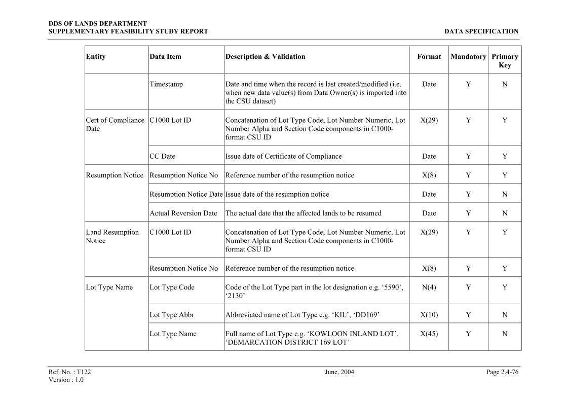
DDS OF LANDS DEPARTMENT SUPPLEMENTARY FEASIBILITY STUDY REPORT DATA SPECIFICATION
Ref. No. : T122 June, 2004 Page 2.4-76 Version : 1.0
Entity Data Item Description & Validation Format Mandatory Primary Key
Timestamp Date and time when the record is last created/modified (i.e. when new data value(s) from Data Owner(s) is imported into the CSU dataset)
Date Y N
C1000 Lot ID Concatenation of Lot Type Code, Lot Number Numeric, Lot Number Alpha and Section Code components in C1000-format CSU ID
X(29) Y Y Cert of Compliance Date
CC Date Issue date of Certificate of Compliance Date Y Y
Resumption Notice No Reference number of the resumption notice X(8) Y Y
Resumption Notice Date Issue date of the resumption notice Date Y N
Resumption Notice
Actual Reversion Date The actual date that the affected lands to be resumed Date Y N
C1000 Lot ID Concatenation of Lot Type Code, Lot Number Numeric, Lot Number Alpha and Section Code components in C1000-format CSU ID
X(29) Y Y Land Resumption Notice
Resumption Notice No Reference number of the resumption notice X(8) Y Y
Lot Type Code Code of the Lot Type part in the lot designation e.g. ‘5590’, ‘2130’
N(4) Y Y
Lot Type Abbr Abbreviated name of Lot Type e.g. ‘KIL’, ‘DD169’ X(10) Y N
Lot Type Name
Lot Type Name Full name of Lot Type e.g. ‘KOWLOON INLAND LOT’, ‘DEMARCATION DISTRICT 169 LOT’
X(45) Y N
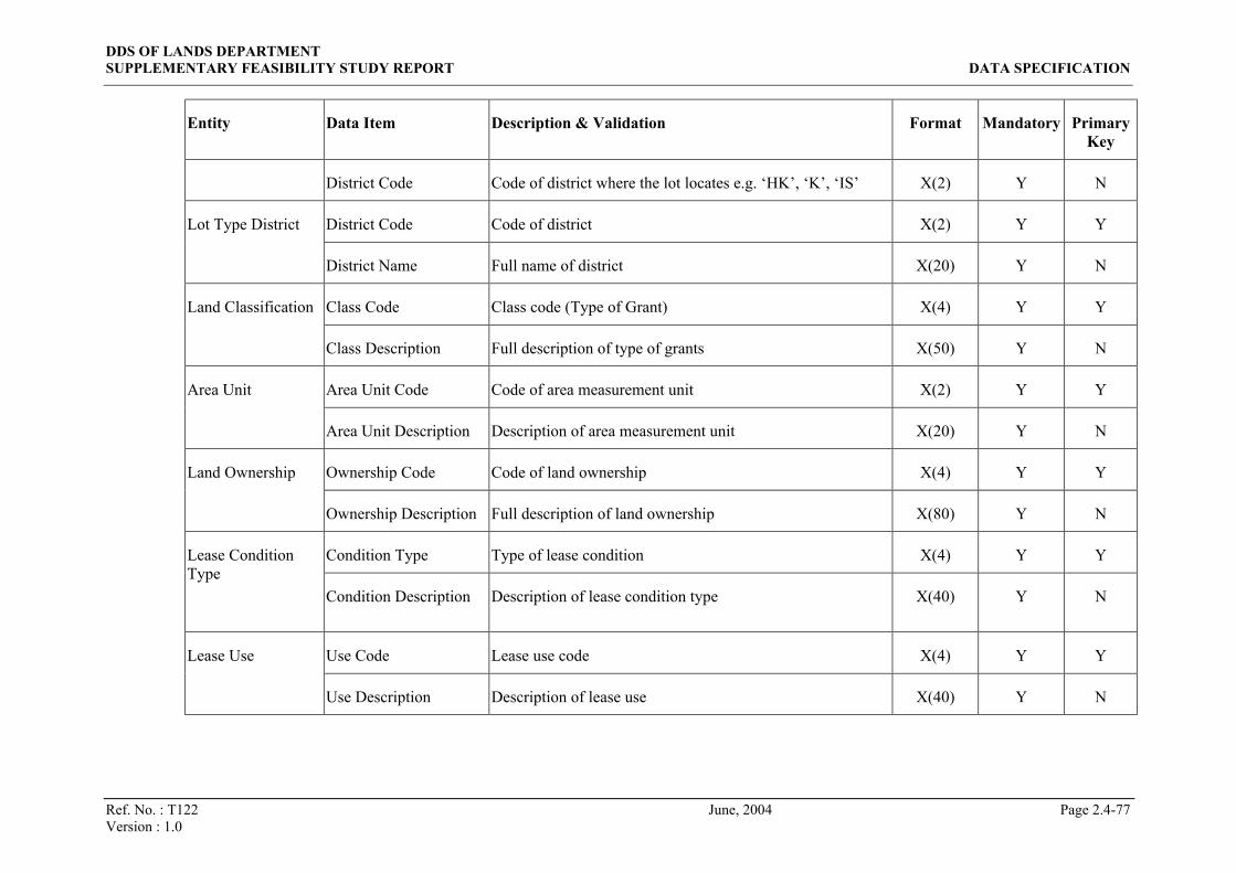
DDS OF LANDS DEPARTMENT SUPPLEMENTARY FEASIBILITY STUDY REPORT DATA SPECIFICATION
Ref. No. : T122 June, 2004 Page 2.4-77 Version : 1.0
Entity Data Item Description & Validation Format Mandatory Primary Key
District Code Code of district where the lot locates e.g. ‘HK’, ‘K’, ‘IS’ X(2) Y N
District Code Code of district X(2) Y Y Lot Type District
District Name Full name of district X(20) Y N
Class Code Class code (Type of Grant) X(4) Y Y Land Classification
Class Description Full description of type of grants X(50) Y N
Area Unit Code Code of area measurement unit X(2) Y Y Area Unit
Area Unit Description Description of area measurement unit X(20) Y N
Ownership Code Code of land ownership X(4) Y Y Land Ownership
Ownership Description Full description of land ownership X(80) Y N
Condition Type Type of lease condition X(4) Y Y Lease Condition Type
Condition Description Description of lease condition type X(40) Y N
Use Code Lease use code X(4) Y Y Lease Use
Use Description Description of lease use X(40) Y N
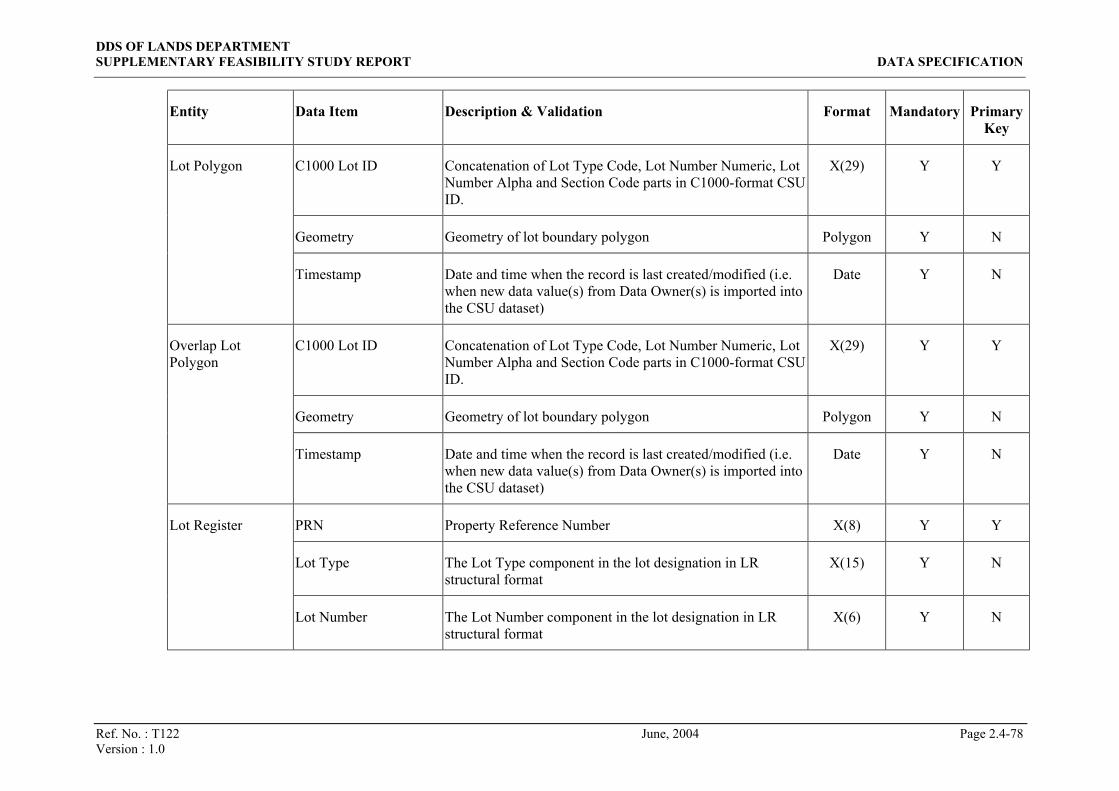
DDS OF LANDS DEPARTMENT SUPPLEMENTARY FEASIBILITY STUDY REPORT DATA SPECIFICATION
Ref. No. : T122 June, 2004 Page 2.4-78 Version : 1.0
Entity Data Item Description & Validation Format Mandatory Primary Key
C1000 Lot ID Concatenation of Lot Type Code, Lot Number Numeric, Lot Number Alpha and Section Code parts in C1000-format CSU ID.
X(29) Y Y
Geometry Geometry of lot boundary polygon Polygon Y N
Lot Polygon
Timestamp Date and time when the record is last created/modified (i.e. when new data value(s) from Data Owner(s) is imported into the CSU dataset)
Date Y N
C1000 Lot ID Concatenation of Lot Type Code, Lot Number Numeric, Lot Number Alpha and Section Code parts in C1000-format CSU ID.
X(29) Y Y
Geometry Geometry of lot boundary polygon Polygon Y N
Overlap Lot Polygon
Timestamp Date and time when the record is last created/modified (i.e. when new data value(s) from Data Owner(s) is imported into the CSU dataset)
Date Y N
PRN Property Reference Number X(8) Y Y
Lot Type The Lot Type component in the lot designation in LR structural format
X(15) Y N
Lot Register
Lot Number The Lot Number component in the lot designation in LR structural format
X(6) Y N

DDS OF LANDS DEPARTMENT SUPPLEMENTARY FEASIBILITY STUDY REPORT DATA SPECIFICATION
Ref. No. : T122 June, 2004 Page 2.4-79 Version : 1.0
Entity Data Item Description & Validation Format Mandatory Primary Key
Section 1 The Section 1 component in the lot designation in LR structural format. i.e. the first section appeared in a lot designation
X(4) N N
Subsection 1 The Subsection 1 component in the lot designation in LR structural format. i.e. the first subsection appeared in a lot designation
X(4) N N
Section 2 The Section 2 component in the lot designation in LR structural format. i.e. the second section appeared in a lot designation
X(4) N N
Subsection 2 The Subsection 2 component in the lot designation in LR structural format. i.e. the second subsection appeared in a lot designation
X(2) N N
Section 3 The Section 3 component in the lot designation in LR structural format. i.e. the third section appeared in a lot designation
X(4) N N
Subsection 3 The Subsection 3 component in the lot designation in LR structural format. i.e. the third subsection appeared in a lot designation
X(2) N N
Section 4 The Section 4 component in the lot designation in LR structural format. i.e. the forth section appeared in a lot designation
X(4) N N

DDS OF LANDS DEPARTMENT SUPPLEMENTARY FEASIBILITY STUDY REPORT DATA SPECIFICATION
Ref. No. : T122 June, 2004 Page 2.4-80 Version : 1.0
Entity Data Item Description & Validation Format Mandatory Primary Key
Extension ‘(EX)’ if the lot designation ends with ‘AND THE EXTENSION THERETO’;
Null otherwise
X(4) N N
Miscellaneous Item Indicator of peculiar lots, where
Null = normal lot
Non-null value (normally 9100 or above) = peculiar lot
N(4) N N
Eng Lot Description The textual lot designation in English. Long translation form is used instead of abbreviated form. E.g. ‘KOWLOON INLAND LOT 123’, ‘DD 360 LOT 1’, ‘THE EXTENSION TO REMAINING PORTION OF INLAND LOT NO.269A’
X(320) Y N
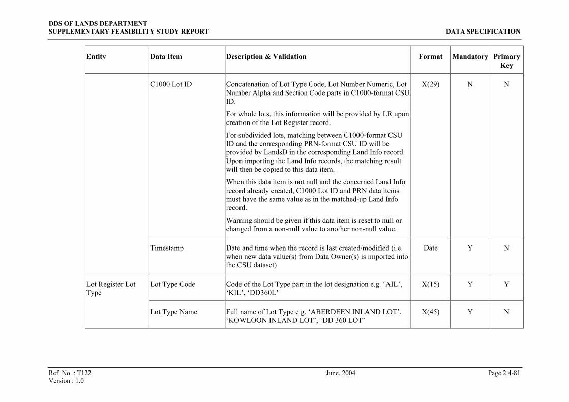
DDS OF LANDS DEPARTMENT SUPPLEMENTARY FEASIBILITY STUDY REPORT DATA SPECIFICATION
Ref. No. : T122 June, 2004 Page 2.4-81 Version : 1.0
Entity Data Item Description & Validation Format Mandatory Primary Key
C1000 Lot ID Concatenation of Lot Type Code, Lot Number Numeric, Lot Number Alpha and Section Code parts in C1000-format CSU ID.
For whole lots, this information will be provided by LR upon creation of the Lot Register record.
For subdivided lots, matching between C1000-format CSU ID and the corresponding PRN-format CSU ID will be provided by LandsD in the corresponding Land Info record. Upon importing the Land Info records, the matching result will then be copied to this data item.
When this data item is not null and the concerned Land Info record already created, C1000 Lot ID and PRN data items must have the same value as in the matched-up Land Info record.
Warning should be given if this data item is reset to null or changed from a non-null value to another non-null value.
X(29) N N
Timestamp Date and time when the record is last created/modified (i.e. when new data value(s) from Data Owner(s) is imported into the CSU dataset)
Date Y N
Lot Type Code Code of the Lot Type part in the lot designation e.g. ‘AIL’, ‘KIL’, ‘DD360L’
X(15) Y Y Lot Register Lot Type
Lot Type Name Full name of Lot Type e.g. ‘ABERDEEN INLAND LOT’, ‘KOWLOON INLAND LOT’, ‘DD 360 LOT’
X(45) Y N
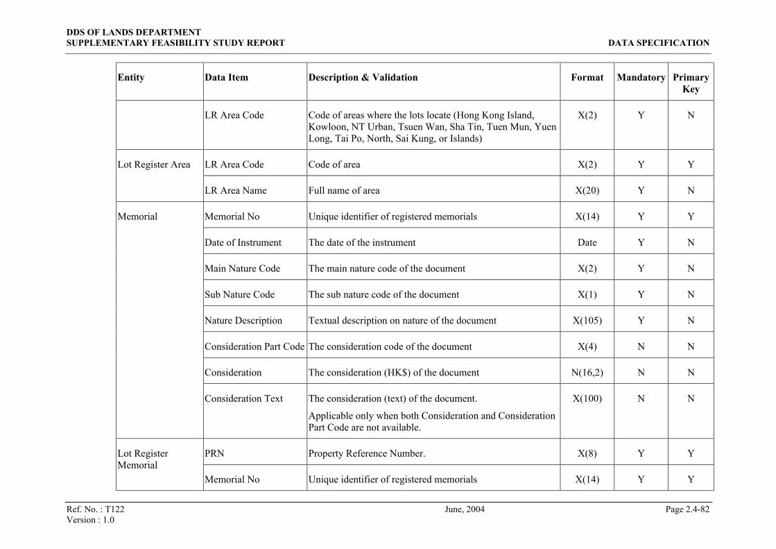
DDS OF LANDS DEPARTMENT SUPPLEMENTARY FEASIBILITY STUDY REPORT DATA SPECIFICATION
Ref. No. : T122 June, 2004 Page 2.4-82 Version : 1.0
Entity Data Item Description & Validation Format Mandatory Primary Key
LR Area Code Code of areas where the lots locate (Hong Kong Island, Kowloon, NT Urban, Tsuen Wan, Sha Tin, Tuen Mun, Yuen Long, Tai Po, North, Sai Kung, or Islands)
X(2) Y N
LR Area Code Code of area X(2) Y Y Lot Register Area
LR Area Name Full name of area X(20) Y N
Memorial No Unique identifier of registered memorials X(14) Y Y
Date of Instrument The date of the instrument Date Y N
Main Nature Code The main nature code of the document X(2) Y N
Sub Nature Code The sub nature code of the document X(1) Y N
Nature Description Textual description on nature of the document X(105) Y N
Consideration Part Code The consideration code of the document X(4) N N
Consideration The consideration (HK$) of the document N(16,2) N N
Memorial
Consideration Text The consideration (text) of the document.
Applicable only when both Consideration and Consideration Part Code are not available.
X(100) N N
PRN Property Reference Number. X(8) Y Y Lot Register Memorial
Memorial No Unique identifier of registered memorials X(14) Y Y
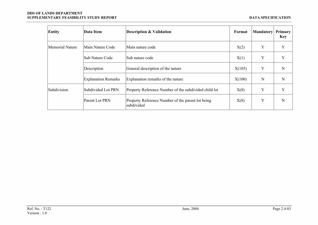
DDS OF LANDS DEPARTMENT SUPPLEMENTARY FEASIBILITY STUDY REPORT DATA SPECIFICATION
Ref. No. : T122 June, 2004 Page 2.4-83 Version : 1.0
Entity Data Item Description & Validation Format Mandatory Primary Key
Main Nature Code Main nature code X(2) Y Y
Sub Nature Code Sub nature code X(1) Y Y
Description General description of the nature X(105) Y N
Memorial Nature
Explanation Remarks Explanation remarks of the nature X(100) N N
Subdivided Lot PRN Property Reference Number of the subdivided child lot X(8) Y Y Subdivision
Parent Lot PRN Property Reference Number of the parent lot being subdivided
X(8) Y N
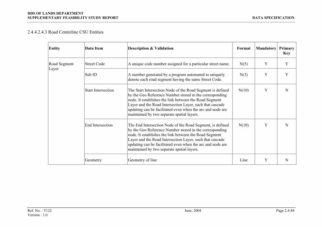
DDS OF LANDS DEPARTMENT SUPPLEMENTARY FEASIBILITY STUDY REPORT DATA SPECIFICATION
Ref. No. : T122 June, 2004 Page 2.4-84 Version : 1.0
2.4.4.2.4.3 Road Centreline CSU Entities
Entity Data Item Description & Validation Format Mandatory Primary Key
Street Code A unique code number assigned for a particular street name. N(5) Y Y
Sub ID A number generated by a program automated to uniquely denote each road segment having the same Street Code.
N(3) Y Y
Start Intersection The Start Intersection Node of the Road Segment is defined by the Geo Reference Number stored in the corresponding node. It establishes the link between the Road Segment Layer and the Road Intersection Layer, such that cascade updating can be facilitated even when the arc and node are maintained by two separate spatial layers.
N(10) Y N
End Intersection The End Intersection Node of the Road Segment, is defined by the Geo Reference Number stored in the corresponding node. It establishes the link between the Road Segment Layer and the Road Intersection Layer, such that cascade updating can be facilitated even when the arc and node are maintained by two separate spatial layers.
N(10) Y N
Road Segment Layer
Geometry Geometry of line Line Y N
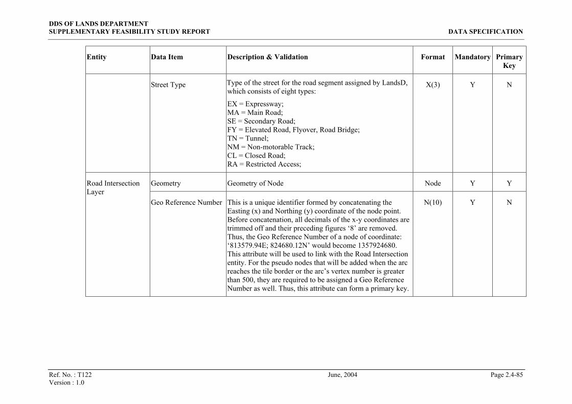
DDS OF LANDS DEPARTMENT SUPPLEMENTARY FEASIBILITY STUDY REPORT DATA SPECIFICATION
Ref. No. : T122 June, 2004 Page 2.4-85 Version : 1.0
Entity Data Item Description & Validation Format Mandatory Primary Key
Street Type Type of the street for the road segment assigned by LandsD, which consists of eight types:
EX = Expressway; MA = Main Road; SE = Secondary Road; FY = Elevated Road, Flyover, Road Bridge; TN = Tunnel; NM = Non-motorable Track; CL = Closed Road; RA = Restricted Access;
X(3) Y N
Geometry Geometry of Node Node Y Y Road Intersection Layer
Geo Reference Number This is a unique identifier formed by concatenating the
Easting (x) and Northing (y) coordinate of the node point. Before concatenation, all decimals of the x-y coordinates are trimmed off and their preceding figures ‘8’ are removed. Thus, the Geo Reference Number of a node of coordinate: ‘813579.94E; 824680.12N’ would become 1357924680. This attribute will be used to link with the Road Intersection entity. For the pseudo nodes that will be added when the arc reaches the tile border or the arc’s vertex number is greater than 500, they are required to be assigned a Geo Reference Number as well. Thus, this attribute can form a primary key.
N(10) Y N

DDS OF LANDS DEPARTMENT SUPPLEMENTARY FEASIBILITY STUDY REPORT DATA SPECIFICATION
Ref. No. : T122 June, 2004 Page 2.4-86 Version : 1.0
Entity Data Item Description & Validation Format Mandatory Primary Key
Geo Reference Number This is an identifier formed by concatenating the Easting (x) and Northing (y) coordinate of the node point. Before concatenation, all decimals of the x-y coordinates are trimmed off and their preceding figures ‘8’ are removed. Thus, the Geo Reference Number of a node of coordinate: ‘813579.94E; 824680.12N’ would become 1357924680. This value is used to map with the Road Intersection layer. For the cross intersection of two roads, more than one record with same Geo Reference Number will be resulted. Thus, this attribute cannot become a primary key.
N(10) Y N
Street Code at the Intersection
Street Code at the intersection point N(5) Y N
Road Intersection
Alternative Street Code at the Intersection
Alternative Street Code at the intersection point N(5) Y N
Street Code A number assigned by LandsD for a particular street. This is a unique code for street.
N(5) Y Y
English Street Name English name of the street. X(80) N N
Road Name
Chinese Street Name Chinese name of the street. CX(50) N N

DDS OF LANDS DEPARTMENT SUPPLEMENTARY FEASIBILITY STUDY REPORT DATA SPECIFICATION
Ref. No. : T122 June, 2004 Page 2.4-87 Version : 1.0
2.4.4.2.4.4 System and Code Entities
Entity Data Item Description & Validation Format Mandatory Primary Key
Start Time Date and time set for starting extraction of CSU data to conform different file format standards
Date Y Y
Task Sequence Sequence of task scheduled base on time N(2) Y Y
CSU Type Type of CSU for execution N(1) Y N
User ID ID of the DA who creates the task X(10) Y N
Task and Schedule Table
Timestamp Date and time when the record created Date Y N
Table Flag A unique identifier to identify each code table X(10) Y Y
Code 1 Code 1 required to support the DDS activities X(10) Y Y
Code 2 Code 2 required to support the DDS activities X(10) Y Y
Description for Code 1 Description for the code 1 X(50) N N
Code Tables
Description for Code 2 Description for the code 2 X(50) N N
User ID A unique identification number assigned to the CSU users including DA, DO and DU
X(10) Y Y User Access Right Control Table
User Name Name of the user X(20) Y N

DDS OF LANDS DEPARTMENT SUPPLEMENTARY FEASIBILITY STUDY REPORT DATA SPECIFICATION
Ref. No. : T122 June, 2004 Page 2.4-88 Version : 1.0
Entity Data Item Description & Validation Format Mandatory Primary Key
Group ID A unique identification number assigned to the group of users who have same access right to the system
X(10) Y Y
Access Right Code The code represents the access right to the system X(10) Y N
Access Right Code Description
The description of the access right code X(50) N N
Job Number A unique identification number assigned to a job queuing for processing
X(10) Y Y
Order ID A unique identification number assigned for the order made by the customer each time
X(10) Y N
Creation Date Date of the job created Date Y N
Execution Date Date of the job executed Date Y N
Completion Date Date of the job completed Date N N
Priority Priority of the job X(2) N N
Status The status of the job X(5) Y N
Job Queue
Remarks Remarks X(50) N N
Transaction Log Function ID A unique identification number assigned to the LandsD users or customers
X(10) Y Y

DDS OF LANDS DEPARTMENT SUPPLEMENTARY FEASIBILITY STUDY REPORT DATA SPECIFICATION
Ref. No. : T122 June, 2004 Page 2.4-89 Version : 1.0
Entity Data Item Description & Validation Format Mandatory Primary Key
User/Customer ID A unique identification number assigned to the LandsD users or customers
X(10) Y Y
Transaction Date Date of transaction Date Y N
Transaction Type Type of transaction X(10) Y N
Action Code Action code X(10) N N
Before Image Image before the transaction X(80) Y N
After Image Image after the transaction X(80) N N