Data Structure Report: Crossreagh West, Portstewart, County
42
Transcript of Data Structure Report: Crossreagh West, Portstewart, County


Data Structure Report: Crossreagh West, Portstewart, County Londonderry
Philip Macdonald
(CAF DSR 007)
(Licence No. AE/02/65)

Contents
Chapter 1: Summary 1
Chapter 2: Introduction 3
Chapter 3: Excavation 9
Chapter 4: Discussion 18
Chapter 5: Recommendations for further work 20
Bibliography 22
Appendix 1: Context list 23
Appendix 2: Harris matrix 25
Appendix 3: Photographic record 26
Appendix 4: Field drawing register 30
Appendix 5: Small finds register 31
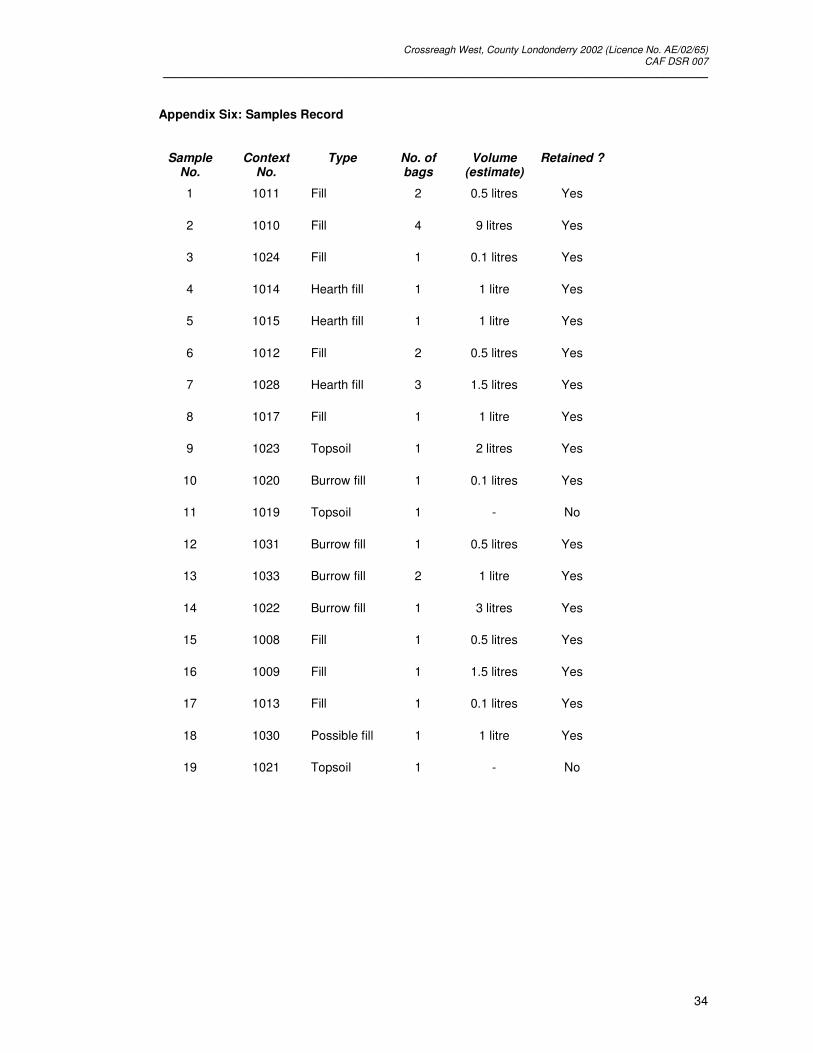
Appendix 6: Samples record 34
Appendix 7: Appendix Seven: Stephen Gilmore’s notes regarding his visit to the
building plot following mechanical excavation of the topsoil 35
Appendix 8: Declan Hurl’s notes regarding his visit to the building plot following
mechanical excavation of the topsoil 36
Plates 37

Crossreagh West, County Londonderry 2002 (Licence No. AE/02/65) CAF DSR 007
__________________________________________________________________________________________________
1
1 Summary
1.1 Background
1.1.1 An archaeological excavation at Crossreagh West, Co. Londonderry (Irish Grid Reference
C82133651) was undertaken in advance of a housing development on a single building
plot at the Meadowlands Housing Estate on the southern outskirts of Portstewart. The
excavation was conducted by the Excavation Unit of the Centre for Archaeological
Fieldwork in the School of Archaeology and Palaeoecology, Queen’s University Belfast on
behalf of the Environment and Heritage Service: Built Heritage.
1.1.2 The site is located within an archaeologically rich landscape which contains sites ranging in
date from the Neolithic to the Post-Medieval period. Within the immediate environs of the
building plot is a megalithic funerary monument excavated by Declan Hurl, Environment
and Heritage Service: Built Heritage in 1995; two large middle Bronze Age structures
excavated by Cormac McSparron, Northern Archaeological Consultancy Ltd in 2000; the
ecclesiastical site of Ballyaghran; and a circular mound which local tradition suggests was
a signal beacon but is possibly a prehistoric barrow.
1.1.3 Following mechanical excavation of the topsoil on the building plot, site visits undertaken
by Mr Stephen Gilmore, Northern Archaeological Consultancy Ltd and Mr Declan Hurl,
Environment and Heritage Service: Built Heritage resulted in traces of several truncated
features cut into the natural subsoil being observed and recorded. These observations,
combined with the proximity of the site to the previously excavated Neolithic funerary
monument and middle Bronze Age structures, led to the Environment and Heritage
Service: Built Heritage deciding that an excavation of the building plot prior to any
construction work being undertaken was necessary.
1.1.4 Excavation of the site duly took place between the 1st and 26th of July 2002. Since the
topsoil stripping of the site over eighteen months previously, the building plot had been
used for dumping quarried stone, rubble and topsoil associated with construction work on
adjacent building plots and had been repeatedly driven over by heavy plant. In addition,
several bonfires had been lit on the site and it had become overgrown with weeds.
1.2 Objectives
1.2.1 The principal research aim of the excavation was to recover any evidence of Neolithic or
Bronze Age activity at the site and, if possible, relate it to that uncovered during the
previous excavations of the adjacent Neolithic funerary monument and middle Bronze Age
structures. In addition, any other archaeological features present at the site were to be

Crossreagh West, County Londonderry 2002 (Licence No. AE/02/65) CAF DSR 007
__________________________________________________________________________________________________
2
excavated and recorded in advance of construction work which was likely to damage or
destroy them.
1.3 Excavation
1.3.1 Initially, the site was cleared of both relict traces of topsoil (Context Nos.1002, 1003 and
1023) and the dumped deposits of general ‘trample’ and building debris (Context
Nos.1001, 1007, 1019 and 1021), quarried stone (Context No.1004) and redeposited
topsoil (Context Nos. 1005, 1006 and 1041). Following this clearance it was revealed that
the features recorded by Stephen Gilmore and Declan Hurl had been either considerably
damaged by the subsequent activity on the site or destroyed altogether. Only nine
truncated features survived; these were all located in the southern half of the site where
the natural subsoil (Context No.1042) was deepest.
1.3.2 The nine features included: an oval-shaped pit of recent date (Context No.1025), six
possible stake holes or small post holes (Context Nos.1026, 1027, 1032, 1036, 1039 and
1040) and a hearth (Context Nos.1016 and 1018). Unfortunately, as well as being severely
truncated, the hearth had been disturbed by several animal burrows (Context Nos.1034,
1035, 1037 and 1038). All nine features were fully excavated. Only one stratigraphic
relationship between these features could be established - one of the possible small post
holes (Context No.1036) cut through part of the hearth (Context No.1016). The features’
distribution across the site did not form any obvious pattern or arrangement to suggest that
they were part of a contemporary structure, although presumably the hearth was originally
located within some form of structure. In the course of the excavation 102 small finds were
recovered (mostly flint flakes but also pottery sherds, burnt bone, glass and clay pipe
stems) although only a few of these were associated with the excavated features.
1.4 Recommendations
1.4.1 The level of preservation of the site was poor and this was reflected in the results of the
excavation which, consequently, do not justify full or detailed publication. The importance
of the excavation lies in its potential for informing the interpretation of the unpublished
excavations of the adjacent Neolithic funerary monument and middle Bronze Age
structures. It is recommended that a short note on the 2002 excavations is prepared for
publication. To facilitate the writing of this note, a limited programme of post-excavation
analysis is proposed.

Crossreagh West, County Londonderry 2002 (Licence No. AE/02/65) CAF DSR 007
__________________________________________________________________________________________________
3
2 Introduction
2.1 General
2.1.1 The following report details the preliminary results of the archaeological excavation at
Crossreagh West, undertaken by the Centre for Archaeological Fieldwork, School of
Archaeology and Palaeoecology at Queen’s University Belfast from the 1st to the 26th of
July 2002 (Licence No. AE/02/65). This excavation was undertaken on behalf of the
Environment and Heritage Services: Built Heritage who funded the project.
2.2 Background
2.2.1 The Crossreagh West excavation was carried out in advance of a housing development on
a single building plot on the Meadowlands Housing Estate situated on the southern
outskirts of Portstewart, in the parish of Ballyaghran, Co. Londonderry (Grid Reference
C82133651) (Figure One). The site is set c.40 metres above sea level on a gentle slope
which overlooks both the River Bann, which is located c.1.1km to the southwest, and the
sand dune system associated with the river’s mouth. The townland of Crossreagh West is
located on the northeastern side of the Bann Estuary in a region geologically dominated
the Quaternary drift deposits which fill the Bann valley and the Cenozoic Upper Basalt
Formation of olivine-basalt lava (Wilson 1972, 64, fig.24; see also Aalen 1997, 15). The
soils surrounding the Bann estuary are made up of various acid brown earths and the area
has a wide land use capability (Aalen 1997, 17-18, figs.29, 32). Prior to the construction of
the Meadowlands Housing Estate, the site was part of an area of enclosed pasture that
was used for growing silage grass and was periodically subjected to shallow ploughing
(D.Hurl pers.comm.).
2.3 Archaeological survey of the site’s environs
2.3.1 The site is located within an archaeologically rich landscape that contains sites ranging in
date from the Neolithic to the Post-Medieval period (Figure Two). Details of the sites and
monuments within 500 metres of the 2002 excavation have been tabulated (Table One).
Within the immediate environs of the building plot is: a megalithic funerary monument
excavated by Declan Hurl, Environment and Heritage Service: Built Heritage in 1995 (SMR
No. LDY 003:002); two large middle Bronze Age structures excavated by Cormac
McSparron, Northern Archaeological Consultancy Ltd in 2000 (McSparron 2000); the
ecclesiastical site of Ballyaghran, first mentioned in 1262 and now consisting of a
curvilinear graveyard and a ruined church which are traditionally associated with a nearby,
but now lost, souterrain (Lewis 1837, 19; Girvan 1972, 37, no.90; Hamlin 1976, 545; Day,
McWilliams and English 1995, 8-9, 16, 22-23; SMR No. LDY 003:003); and a circular

Crossreagh West, County Londonderry 2002 (Licence No. AE/02/65) CAF DSR 007
__________________________________________________________________________________________________
4
mound, which local tradition suggests was a signal beacon but is possibly a prehistoric
barrow (McSparron 2000; SMR No.LDY 003:025).
2.3.2 Other nearby sites and monuments include: two standing stones of uncertain date (SMR
Nos. LDY 003:004-005), one of which has been destroyed (i.e. SMR No. LDY 003:005); an
urn burial discovered during the nineteenth century and whose precise location is now
unknown (SMR No. LDY 003:022); a find spot of various prehistoric lithics and pottery
(May and Batty 1948, 132; SMR No. LDY 003:044); a rath recorded in the Ordnance
Survey Memoirs as a destroyed fort and which can no longer be located (Day, McWilliams
and English 1995, 11; SMR No. LDY 003:029); a possible raised rath called Cashlandoo
(SMR No. LDY 003:006); a circular crop mark which consists of a raised circular area
enclosed by an upstanding bank (SMR No. LDY 003:037); and three alignments of stone,
possibly representing ancient field walls or structures, as well as an area of burning
recorded by Declan Hurl during topsoil stripping in 1994 (SMR No. LDY 003:076) and
identified by John O’Neill from Hurl’s description as a ploughed out burnt mound (J.O’Neill
pers.comm.) (Figure Two). In addition, a ‘castle’ and an associated settlement, reportedly
robbed for stone in the late eighteenth century, are recorded as being sited in the area
(Day, McWilliams and English 1995, 23; SMR No. LDY 003:028). Although their precise
location is no longer known, both are presumably located relatively close to the old church
site of Ballyaghran.
Description SMR No. Grid Reference References
Neolithic funerary monument LDY 003:002 C82133656 Day, McWilliams and English 1995, 10, 16,
24, 25; O’Laverty 1878, 227.
Middle Bronze Age structures N/A C821043651 McSparron 2000
Urn burial LDY 003:022 C8236
Find spot of flints and pottery LDY 003:044 C81893640 May and Batty 1948, 132.
Standing stone LDY 003:004 C82423662
Standing stone LDY 003:005 C82253646
Burnt Mound ? LDY 003:076 C82303657 J.O’Neill pers.comm.
Stone alignments ? LDY 003:076 C82283648
Rath LDY 003:029 C824363 Day, McWilliams and English 1995, 11
Raised rath ? LDY003:006 C82283632
Ecclesiastical site LDY 003:003 C82253658
Lewis 1837, 19; O’Laverty 1878, 224-225;
Girvan 1972, 37, no.90; Hamlin 1976, 545;
Day, McWilliams and English 1995, 8-9, 16,
22-23.
‘Castle’ and settlement LDY 003:028 C8236 Day, McWilliams and English 1995, 23;
O’Laverty 1878, 226.
Signal mound ? LDY 003:025 C82143646
Circular crop mark LDY003:037 C82293663
Table One: Archaeological sites within 500 metres of the 2002 Crossreagh West excavations

Crossreagh West, County Londonderry 2002 (Licence No. AE/02/65) CAF DSR 007
__________________________________________________________________________________________________
5

Crossreagh West, County Londonderry 2002 (Licence No. AE/02/65) CAF DSR 007
__________________________________________________________________________________________________
6

Crossreagh West, County Londonderry 2002 (Licence No. AE/02/65) CAF DSR 007
__________________________________________________________________________________________________
7
2.4 Previous archaeological investigations held in the vicinity of the 2002 excavation site
2.4.1 The Neolithic funerary monument (SMR No.LDY 003:002), excavated by Declan Hurl in
advance of an earlier phase of development of the Meadowlands Housing Estate, is
located c.50 metres to the north of the 2002 excavation site. Today the monument
consists of three upright stone slabs which have been incorporated into a garden feature
(Plate One); however, when recorded by the Ordnance Survey during 1835 the monument
was more extensive (cf. Day, McWilliams and English 1995, 24, 25). In addition to
establishing the extent of the monument, Hurl’s excavations revealed evidence of pits,
possible post holes and gullies cut into both the mound and the natural subsoil of the area
immediately surrounding the monument. Both radiocarbon dating and pottery recovered
from these features indicated separate late Neolithic, early Bronze Age and Medieval
phases of activity. The late Neolithic and early Bronze Age features included a number of
pits containing burnt or pulverised bone and charcoal that were associated with exotic
artefacts, including a saddle quern and a broken macehead. These features are
interpreted as burial pits.
2.4.2 The two middle Bronze Age structures excavated by Cormac McSparron, Northern
Archaeological Consultancy Ltd in advance of a subsequent phase of development of the
Meadowlands Housing Estate were located c.35 - 50 metres to the west of the 2002
excavation site. The first structure was a sub-rectangular house with an apsidal north end
represented by a series of post holes, circular gullies, pits and a hearth, all of which were
cut into the natural subsoil. The second structure was a large sub-circular building with a
smaller circular annex consisting of a series of small post holes or stake holes and a
circular construction slot, again all of which were cut into the natural subsoil. Evidence of
copper smelting was associated with the first structure. The two structures are dated to the
middle Bronze Age on the basis of both artefactual evidence and a single radiocarbon date
associated with the first structure.
2.4.3 In addition to the two excavations, topsoil stripping in advance of the development of an
area c.100 metres by 100 metres immediately to the southeast of the ecclesiastical site of
Ballyaghran was undertaken in 1994. The topsoil stripping was monitored by Declan Hurl
who recorded two sets of separate features. The first, located in an area immediately
adjacent to the eastern most part of the graveyard, consisted of an extensive area of
burning, made up of charcoal, red soil and scorched stones, which was associated with an
irregular-shaped pit was observed. This feature has been identified from Hurl’s description
as a possible ploughed out burnt mound (J.O’Neill pers.comm.). The second set of
features, which were located in an area c.100 metres to the south of the possible burnt
mound, consisted of three alignments of stone that possibly represent ancient field walls or
structures (SMR No. LDY 003:076).

Crossreagh West, County Londonderry 2002 (Licence No. AE/02/65) CAF DSR 007
__________________________________________________________________________________________________
8
2.5 Reason for excavation and research objectives
2.5.1 Following mechanical excavation of the topsoil on the building plot, site visits undertaken
by Stephen Gilmore, Northern Archaeological Consultancy Ltd on the 24th November 2000
(see Appendix Seven) and Declan Hurl, Environment and Heritage Service: Built Heritage
on the 19th February 2001 (see Appendix Eight) led to traces of several truncated features
cut into the natural subsoil being observed and recorded. These observations, combined
with the proximity of the site to both the Neolithic funerary monument excavated in 1995
and the middle Bronze Age structures excavated in 2000, prompted the Environment and
Heritage Service: Built Heritage to deciding that, prior to any construction work, an
excavation of the building plot was necessary.
2.5.2 The aim of the 2002 excavations was to ascertain the character of the archaeological
features recorded by Stephen Gilmore and Declan Hurl following the topsoil stripping of the
site. The principle research objective of the excavation was to recover any evidence of
Neolithic or Bronze Age activity at the site and, if possible, relate it to that uncovered during
the previous excavations of the adjacent Neolithic funerary monument and middle Bronze
Age structures. In addition, any other archaeological features present at the site were to
be excavated and recorded in advance of the construction work which was likely to
damage or destroy them.
2.6 Archiving
2.6.1 A copy of this report has been deposited with the Environment and Heritage Service: Built
Heritage. All site records and finds are temporarily archived within the School of
Archaeology and Palaeoecology, Queen’s University Belfast.
2.7 Credits and Acknowledgements
2.7.1 The excavation was directed by Philip Macdonald and supervised by Bronagh Murray. The
excavation team consisted of Nicholas Beer, Graeme Heyburn, Sonja Laus, Daniel Reilly
and Brian Sloan.
2.7.2 Assistance during the course of the excavation and the preparation of this report was
kindly provided by: Paul Crawley (The Anchor Bar, Portstewart), John Davison (Queen’s
University Belfast), Colm Donnelly (Queen’s University Belfast), Stephen Gilmore
(Northern Archaeological Consultancy Ltd), Declan Hurl (Environment and Heritage
Service: Built Heritage), John O’Neill (Queen’s University Belfast) and Cormac McSparron
(Queen’s University Belfast). The illustrations were prepared by Keith Adams and Bronagh
Murray of the Centre for Archaeological Fieldwork, Queen’s University Belfast.

Crossreagh West, County Londonderry 2002 (Licence No. AE/02/65) CAF DSR 007
__________________________________________________________________________________________________
9
3 Excavation
3.1 Methodology
3.1.1 The excavation consisted of a single L-shaped trench sited across the eastern, southern
and western quarters of the building plot (Figure Three). The northeast to southwest
aligned part of the excavation trench extended for a distance of 16.15 metres and was
10.45 metres wide, whilst the additional area included within the northwest to southeast
aligned part of the trench extended for a distance of c.7.50 metres and was 7.00 metres
wide. For the purposes of creating a convenient site grid, a site north (equivalent to true
northeast) was established. To avoid confusion all references to cardinal directions within
this report have been corrected; however, references in the primary site records have not
been altered.
3.1.2 Subsequent to the topsoil stripping of the site over eighteen months previously, the building
plot had been used for dumping quarried stone, rubble and topsoil associated with
construction work on adjacent building plots. In addition, the site had also been repeatedly
driven over by heavy plant, had had several bonfires lit on it and had become overgrown
with weeds (Plate Two). Following the removal and excavation of these modern deposits a
small number of relatively easily recognised, truncated, negative features cut into the
orange sandy clay loam natural subsoil (Context No.1042) were observed. All of the
features were excavated and recorded. In addition, a sondage in the eastern corner of the
site was dug to confirm that a thick deposit of modern redeposited topsoil (Context
No.1041) overlay the truncated surface of the natural subsoil (Context No.1042). Following
the completion of the site recording, and at the request of the developer, only those parts
of the excavation which would have presented a safety risk to the public, if left open, were
backfilled.
3.1.3 Excavation was undertaken by hand and the context record for the site was created using
the standard context recording method. Large scale plans (Scale 1:50) were prepared of
the site following both its initial clearance and the removal of the superficial sequence of
modern deposits. Individual features were planned (Scales 1:10 and 1:20) and
photographed both prior to, and following, excavation. Section drawings were completed
of both the fills of significant negative features (Scale 1:10) and the sondage cut in the
eastern corner of the site (Scale 1:20) (for details of site photography see Appendix Three
and for field illustrations see Appendix Four). In addition to the photography and
illustration, the principal site records consisted of context sheets augmented by a
supervisor’s notebook, as well as separate registers of small finds (Appendix Five) and
samples (Appendix Six). The unique site code used to identify the records generated
during the excavation is CRW 02.

Crossreagh West, County Londonderry 2002 (Licence No. AE/02/65) CAF DSR 007
__________________________________________________________________________________________________
10

Crossreagh West, County Londonderry 2002 (Licence No. AE/02/65) CAF DSR 007
__________________________________________________________________________________________________
11
3.2 Account of the excavations
3.2.1 It is intended that the Harris matrix for the site (see Appendix Two) is referred to whilst
reading the following account of the stratigraphic sequence of the excavation.
3.2.2 An arbitrary context number (Context No.1001) was used to record finds made during the
initial clearance of the site. This clearance involved the removal of a spit (maximum depth
0.05 metres) of disturbed deposits across the entire site. Material removed during the
clearance included several dumps of building materials (such as tarmac, gravel, building
sand, concrete and cement), topsoil (presumably redeposited from adjoining building
sites), ashy deposits associated with recent bonfires, and grass cuttings. Modern finds
derived from adjoining building plots, such as roof tile fragments, nails, polystyrene and
plastic sheeting, were not retained.
3.2.3 The surface revealed by the site clearance had been heavily disturbed. The features
recorded by Stephen Gilmore and Declan Hurl had been considerably damaged, or
destroyed altogether, as a result of activity on the building plot following the initial topsoil
stripping. The preservation of several tyre tracks from heavy plant and large vehicles
within the exposed surface of the natural subsoil indicates the principal cause of this
damage.
3.2.4 Following the clearance of the site several types of deposit and feature were recognised.
These included relict areas of topsoil which had not been removed during the initial
evaluation of the site (Context Nos.1002, 1003, 1023), as well as deposits of general
‘trample’ (Context Nos.1007, 1019 and 1021), dumped quarried stone (Context No.1004)
and redeposited topsoil (Context Nos. 1005, 1006, 1041) which all post-dated the topsoil
stripping. Only nine truncated features, all of which were cut into the natural subsoil
(Context No.1042), survived. These were all located in the southern half of the site where
the natural subsoil (Context No.1042) was deepest. The nine features included: an oval-
shaped pit of recent date (Context No.1025), six possible stake holes or small post holes
(Context Nos.1026, 1027, 1032, 1036, 1039, 1040) and a hearth (Context Nos.1016,
1018). Several animal burrows were also preserved (Context Nos.1034, 1035, 1037,
1038), including two which had disturbed the hearth (i.e. Context Nos.1037 and 1038).
3.3 Modern deposits and features
3.3.1 The areas of relict topsoil extended across the western part (Context No.1002), the
northeastern corner (Context No.1003) and the southern corner (Context No.1023) of the
trench. The western area of relict topsoil (Context No.1002) extended over an irregular-
shaped area 15.0 metres by 7.0 metres in size, the relict topsoil in the northeastern corner

Crossreagh West, County Londonderry 2002 (Licence No. AE/02/65) CAF DSR 007
__________________________________________________________________________________________________
12
of the site (Context No.1003) extended across an area 3.75 metres by 7.50 metres, while
the relict topsoil in the southern corner of the site (Context No.1023) extended over an area
0.55 metres by 0.55 metres. The depth of topsoil removed varied, but had a maximum
depth of 0.10 metres. All three areas were located in parts of the site where the basalt
bedrock lay close to the surface and it would not have been possible to remove the topsoil
by machine. The relict topsoil deposits all consisted of a firm, dark brown, humic sandy
loam with occasional charcoal flecks and small stone inclusions. The deposits had all
been compacted, presumably as a result of having been driven over by heavy plant.
Although all three areas of topsoil were fully excavated, to reveal either the underlying
natural subsoil (Context No.1042) or bedrock surfaces, no additional features or deposits
were exposed. In addition to the recorded finds (see Appendix Five), a large amount of
modern building debris was recovered from the areas of relict topsoil but was not retained.
3.3.2 Three shallow deposits of topsoil (Context Nos.1007, 1019 and 1021) ‘trampled’ into
hollows within the surface of the natural subsoil (Context No.1042) after the topsoil
stripping had been completed, were initially identified as possible features and therefore
excavated. The first was a sub-circular shaped, shallow deposit of dark brown humic
sandy clay loam (diameter 0.12 - 0.16 metres, depth 0.04 metres) in the southern half of
the site (Context No.1007). The second was an irregular-shaped deposit of a dark brown
silty loam (dimensions 0.08 by 0.14 metres, depth 0.03 metres) in the southern corner of
the site (Context No.1019). The third was an elongated deposit of dark brown, humic
sandy loam (dimensions 1.40 metres by 0.23 metres, depth 0.02 metres) also in the
southern corner of the site.
3.3.3 A dump of quarried stone (Context No.1004) was located in the eastern end of the site and
was exposed over an area 7.0 metres by 6.5 metres. It consisted of an irregular-shaped
deposit of sub-angular to angular stone fragments of varying size (the largest stones had
maximum dimensions of 0.25 metres). Due to time constraints, the dump was only
partially excavated by means of a sondage cut in the eastern corner of the site where it
was demonstrated that it was 0.1 metres in depth and overlay deposits of redeposited
topsoil (Context Nos.1005, 1006 and 1041). During the course of the excavation the owner
of a nearby house confirmed that the stones were derived from bedrock quarried from an
adjacent building plot during September 2001.
3.3.4 Underlying the dump of quarried stone (Context Nos.1004) were two separate deposits of
dark brown, humic sandy clay loam, topsoil (Context Nos. 1005, 1006, 1041) which had
been redeposited on to the truncated surface of the natural subsoil following the topsoil
stripping of the site. Both of these deposits were partially excavated in order to confirm
their recent date. The first (Context No.1005) was a shallow, irregular-shaped deposit
(depth 0.02 metres) located on the western edge of the stone dump. The second dump of

Crossreagh West, County Londonderry 2002 (Licence No. AE/02/65) CAF DSR 007
__________________________________________________________________________________________________
13
redeposited topsoil (Context Nos.1006 and 1041) was exposed in the sondage in the
eastern corner of the site for a length of 4.80 metres. The deposit contained several
lenses of builder’s sand and had a maximum depth of 0.40 metres. Presumably, these
deposits of redeposited topsoil were derived from the clearance of nearby building plots in
advance of construction work.
3.3.5 The only demonstrably modern, negative feature investigated during the course of the
excavation was a truncated oval-shaped pit (dimensions 0.70 by 0.50 metres, depth 0.28
metres) located in the southern half of the site (Context No.1025). The pit was filled by a
firm, dark brown sandy clay loam with occasional charcoal flecking and several small stone
inclusions (Context No.1010) from which two pieces of modern glass were recovered
(Small Find Nos. 180 and 183; see Appendix Five). The absence of building debris within
the pit’s fill suggests that it predates the construction of the Meadowlands Estate.
3.4 Possible ancient features and animal burrows
3.4.1 Six truncated possible stake holes or small post holes (Context Nos.1026, 1027, 1032,
1036, 1039, 1040), all located in the southern half of the site, were excavated. Little
artefactual material suitable for dating purposes was recovered from these features and
their date is uncertain. Roots ran through the fills of all of the features and, although all of
the fills were sampled with a view to recovering organic material suitable for radiocarbon
dating, it is unlikely that these samples will not be contaminated.
3.4.2 The first feature (Context No.1026) was sub-circular in shape with a rounded base
(diameter 0.18-0.19 metres; depth 0.10 metres), it was located adjacent to the
southeastern edge of excavation and filled with a friable dark brown loam (Context
No.1011). The second feature (Context No.1027) was sub-oval in shape with a rounded
base (diameter 0.12-0.13 metres; depth 0.06 metres), it was also located adjacent to the
southeastern edge of excavation (c.0.5 metres to the south of the first feature) and filled
with a dark brown loam (Context No.1012). The third feature (Context No.1032) was
circular in shape with steep sides and a base defined by the bedrock (diameter 0.12
metres; depth 0.03 metres), it was located towards the centre of the southern half of the
site and was filled with a dark brown silty loam (Context No.1008). The fourth feature
(Context No.1036) was sub-circular in shape with steep sides (diameter 0.21-0.25 metres,
depth 0.19 metres), it was located near the southern corner of the site and was cut through
the upper fill (Context No.1014) of part of the hearth (Context No.1016) (see below). It was
filled by a charcoal flecked, mid to dark brown loam (Context No.1030) which contained a
large sub-angular stone at its base (maximum dimension 0.17 metres) which might
represent packing. The fifth feature (Context No.1039) was a shallow, sub-circular hollow
(diameter 0.17-0.21 metres, depth 0.06 metres), that was located near the southern corner
Crossreagh West, County Londonderry 2002 (Licence No. AE/02/65) CAF DSR 007
__________________________________________________________________________________________________
14
of the site and filled with a charcoal flecked, dark brown sandy clay loam (Context
No.1013). The sixth feature (Context No.1040) was sub-circular in shape with a rounded
base (diameter 0.22-0.33 metres, depth 0.08 metres), it was located c.0.5 metres to the
south of the modern pit (Context No.1025) and filled with a charcoal flecked, dark brown
sandy loam (Context No.1009).
3.4.3 All of the features had been truncated and three of them (i.e. Context Nos.1027, 1032 and
1039) were so shallow that their identification as possible stake holes or small post holes is
particularly problematic. Of the remaining features, the only one which can be identified
with reasonable confidence as a definite stake hole or post hole is the example (Context
No.1036) which stratigraphically cut the hearth and whose fill (Context No.1030) contained
a possible packing stone.
3.4.4 The only other significant feature was the shallow remains of a hearth (Context Nos.1016
and 1018) which was located in the southern corner of the site (Figures Four and Five;
Plates Four and Five). The base of the hearth appeared to have been originally a linear
feature, 1.4 metres long, 0.3 - 0.45 metres wide and aligned approximately east-west;
however, as a result of its truncation it had become two separate stratigraphic units set
0.04 metres apart from each other. The eastern unit (Context No.1016) was oval in shape
(diameter 0.64 - 0.43 metres, depth 0.07 metres), whilst the western unit (Context
No.1018) was sub-rectangular in shape (length 0.65 metres, width 0.36 metres, depth 0.03
metres).
3.4.5 Both parts of the hearth have comparable stratigraphic sequences. The primary fill of the
slightly better preserved eastern unit (Context No.1016) was a charcoal flecked, brown
sandy loam with small pebble inclusions (thickness 0.03-0.04 metres). It was overlain by a
charcoal rich, dark brown to black sandy loam (thickness 0.03 metres) (Context No.1015)
which contained a lens of light brown sand (thickness 0.01 metres) (Context No.1024).
The charcoal rich fill (Context No.1015) was in turn overlain by a charcoal flecked, reddish-
brown sandy loam set within the centre of the feature (dimensions 0.25 metres by 0.43
metres, thickness 0.04 metres). The primary fill of the western unit (Context No.1018)
consisted of a deposit of sub-rounded stones apparently deliberately spread across the
base of the hearth (Context No.1029). The spread of stones was overlain by a charcoal
rich, dark brown to black sandy loam (thickness 0.03 metres) (Context No.1017) and is
equated with the comparable fill in the eastern unit (i.e. Context No.1015).
3.4.6 The eastern part of the hearth (Context No.1016) was cut by two animal burrows (Context
Nos.1037 and 1038). These animal burrows were partially excavated in order to establish
that they were not anthropogenic. In addition to the two burrows which cut the hearth
feature, two other burrows (Context Nos.1034 and 1035) in the southern corner of the site

Crossreagh West, County Londonderry 2002 (Licence No. AE/02/65) CAF DSR 007
__________________________________________________________________________________________________
15

Crossreagh West, County Londonderry 2002 (Licence No. AE/02/65) CAF DSR 007
__________________________________________________________________________________________________
16
were also partially excavated. The date of the burrows is uncertain; however, considering
the acidic soil conditions, the survival of a piece of bone (Small Find Nos.201) within the fill
(Context Nos.1022) of one of the burrows (Context Nos.1035) suggests that at least one
burrow is of relatively recent date.
3.4.7 The distribution of the six possible stake holes or small post holes (Context Nos.1026,
1027, 1032, 1036, 1039, 1040) and the hearth (Context Nos.1016 and 1018) did not form
any obvious pattern or arrangement to suggest that they were part of a contemporary
structure, although presumably the hearth was originally located within some form of
structure.
3.5 Artefactual dating
3.5.1 In the course of the excavation 102 small finds were recovered, although only a few of
these were associated with the excavated features (see Appendix Five). Most of the finds
consist of worked flint, pottery sherds and burnt bone. Two fragments of modern glass
(Small Find Nos.180 and 183), a possible rubbing stone (Small Find No.111) and two
pieces of clay pipe stem (Small Find Nos.140 and 151) were also recovered.
3.5.2 A total of 14 sherds of pottery (Small Find Nos. 103, 104, 108, 120, 134, 153, 157, 161,
165, 176, 177, 195, 203 and 204), all from modern or disturbed contexts, were recovered
during the excavations. Provisional analysis indicates that the majority of the sherds are
eighteenth century or later in date; however, two sherds (Small Find Nos.108 and 120) are
examples of an apparently local earthenware and are difficult to date precisely, but
probably range in date from the Medieval period to the eighteenth or nineteenth century
(McSparron pers.comm.). Considering the small size of the ceramic assemblage, the
presence of the sherds is consistent with nothing necessarily more significant than the use
of kitchen middens to manure fields during the Medieval and Post-Medieval periods.
3.5.3 The acidic soil conditions of the site prevented the preservation of any unburnt animal bone
apart from two pieces (Small Find Nos.201-202) which were recovered from the fill of a
presumably recent animal burrow (Context No.1022) and a dump of redeposited topsoil
(Context No.1041) which post-dates the mechanical excavation of the site’s topsoil.
Eleven fragments of burnt bone were recovered (Small Find Nos.119, 138, 150, 159, 160,
168, 172, 192, 196, 197 and 200); one of these (Small Find No.172) was recovered from a
fill (Context No.1017) of the hearth, whilst the remainder were recovered from either
modern or disturbed contexts.
3.5.4 The relatively large number of worked flints recovered during the excavations suggests the
site, or its immediate environs, was a focus of prehistoric activity. Only two flint flakes were

Crossreagh West, County Londonderry 2002 (Licence No. AE/02/65) CAF DSR 007
__________________________________________________________________________________________________
17
recovered from significant contexts; the first (Small Find No.173) was recovered from a fill
(Context No.1017) of the hearth (Context No.1018), whilst the second (Small Find No.174)
was recovered from the fill (Context No.1011) of a possible stake hole (Context No.1026).
Provisional analysis of the assemblage has resulted in the recognition of only one
diagnostic type, that is a Neolithic or Early Bronze Age scraper (Small Find No.101) which
was discovered during the initial clearance of the site.

Crossreagh West, County Londonderry 2002 (Licence No. AE/02/65) CAF DSR 007
__________________________________________________________________________________________________
18
4 Discussion
4.1 The 2002 excavation was only partially successful in ascertaining the character of the
deposits recorded by Stephen Gilmore and Declan Hurl (see Appendices Six and Seven).
In the period of approximately eighteen months between the mechanical excavation of the
building plot’s topsoil (November 2000) and the excavations (July 2002), a significant
proportion of the recorded features were destroyed. Gilmore identified five features in the
southern half of the site: a possible hearth, a stone packed feature, an oval pit and two
linear features, one of which terminated in a stone packed post hole (see Appendix
Seven). Of these five features, only the possible hearth (Context Nos.1016 and 1018) and
the oval pit (Context No.1025) survived to be recorded in the 2002 excavations. The poor
level of preservation was a result of the truncation of the archaeological horizon exposed
by the topsoil stripping. This truncation was caused by driving heavy plant and large
vehicles over the building plot and the use of the area for dumping large quantities of
quarried stone, building material and general waste.
4.2 The level of preservation of the site was poor and this was reflected in the results of the
excavation. The only excavated features of potential archaeological significance were the
six possible stake holes or small post holes (Context Nos.1026, 1027, 1032, 1036, 1039
and 1040) and the hearth (Context Nos.1016 and 1018) located in the southern part of the
site. These features did not form any pattern or arrangement to suggest that they were
part of a contemporary structure, although presumably the hearth was originally located
within some form of structure. That one of the small post holes (Context No.1036) cut
through part of the hearth suggests that there were probably at least two separate phases
of activity at the site.
4.3 At present, it is not possible to suggest a date for either the hearth or any of the possible
stake holes or small post holes. The relatively large number of worked flints recovered
during the excavation suggests the site, or at least the area immediately surrounding it,
was a focus of prehistoric activity. However, given the scale of residual deposition of
worked flint in demonstrably later contexts, the recovery of two flint flakes (Small Find
Nos.173 and 174) from fills associated with the hearth feature (Context No.1018) and one
of the possible stake holes (Context No.1026) cannot be taken as demonstrating a
prehistoric date for these features. This is particularly regrettable as the principle research
objective of the excavation was to recover any evidence of Neolithic or Bronze Age activity
at the site and, if possible, relate it to that uncovered during the earlier excavations of the
adjacent Neolithic funerary monument and middle Bronze Age structures.
4.4 The inherent importance of the features recorded during the 2002 excavation is not great.
Their archaeological significance relates to the light that they potentially cast on the activity

Crossreagh West, County Londonderry 2002 (Licence No. AE/02/65) CAF DSR 007
__________________________________________________________________________________________________
19
uncovered in the earlier excavations of the adjacent Neolithic funerary monument and
middle Bronze Age structures. If it was demonstrated that the features were of late
Neolithic or early Bronze Age date then the activity recognised in the area immediately
surrounding the Neolithic funerary monument during Hurl’s excavations could be argued to
extend further south than has hitherto been recognised. Alternatively, if it was shown that
the features were of middle Bronze Age date then it would suggest that the settlement
evidence uncovered during McSparron’s excavations was more extensive than has hitherto
been demonstrated.

Crossreagh West, County Londonderry 2002 (Licence No. AE/02/65) CAF DSR 007
__________________________________________________________________________________________________
20
5 Recommendations for further work
5.1 Introduction
5.1.1 The results of the 2002 excavation at Crossreagh West do not justify full and detailed
publication. The excavation’s importance lies in its potential for informing the interpretation
of the results of the unpublished excavations of the adjacent Neolithic funerary monument
and middle Bronze Age structures. Consequently, it is recommended that a limited
programme of post-excavational analysis is undertaken and that a short note on the
excavations is prepared for publication. It is anticipated that the note will be submitted to
the Ulster Journal of Archaeology.
5.1.2 In order to satisfactorily complete the post-excavation analysis and prepare a short note for
publication the following four tasks have been identified. A time-table for the completion of
this work has also been proposed (Table Two).
5.2 Programme of radiocarbon dating of material recovered during the 2002 excavations
[to be completed by September 2003]
5.2.1 Given the high risk of contamination caused by root action, animal burrowing and the
activity on the site following the mechanical excavation of the topsoil, it is not considered
worthwhile to prepare charcoal samples for radiocarbon dating by floating the soil samples
taken from the fills of the six possible stake holes or small post holes. Consequently, only
a single radiocarbon date of the in situ charcoal deposits (Context Nos.1015 and.1017)
from the hearth is recommended.
5.3 Specialist identification and dating of pot sherds [to be completed by September 2003]
5.3.1 The assemblage of pot sherds recovered during the excavation is not of central importance
to the interpretation of the site. However, it is necessary for a specialist to confirm, and if
appropriate revise, the provisional identifications of the small assemblage of pot sherds
recovered during the excavations. It is not recommended that a formal report on the
pottery should be prepared for publication.
5.4 Specialist analysis of the flint [to be completed by September 2003]
5.4.1 The worked flint assemblage recovered during the excavations is the only artefactual
signature of the character of prehistoric activity at the site. Analysis of the flint assemblage
will facilitate comparison with the worked flint recovered during the excavations of the

Crossreagh West, County Londonderry 2002 (Licence No. AE/02/65) CAF DSR 007
__________________________________________________________________________________________________
21
adjacent Neolithic funerary monument and middle Bronze Age structures. It is envisaged
that a summary of the analysis will be included in the published note on the excavation.
5.5 Preparation of note for publication [to be completed by December 2003]
5.5.1 Preparing the short note will involve incorporating the results of the proposed radiocarbon
dating and the specialist analyses into a summary account of the 2002 excavation derived
from this report. The note will be c.1000 - 1500 words in length and will include illustrations
adapted from this report. The preparation and submission of the note will take a week of
staff time and should be programmed into the first half of the Centre for Archaeological
Fieldwork’s 2003/2004 post-excavation season.
Tasks April – June 2003 July – September 2003 October – December 2003
Radiocarbon dating
Analysis of pottery
Analysis of flint
Preparation of note for publication
Table Two: Proposed time-table for completion of the proposed programmes of post-excavation
analysis and publication (areas shaded grey show period during which work is to be undertaken
and completed)

Crossreagh West, County Londonderry 2002 (Licence No. AE/02/65) CAF DSR 007
__________________________________________________________________________________________________
22
Bibliography
Aalen, F.H.A. 1997. The Irish rural landscape: synthesis of habitat and history, in F.H.A.Aalen,
K.Whelan and M.Stout (eds), Atlas of the Irish rural landscape, Cork University Press, Cork. 4-30.
Day, A., McWilliams, P. and English, L. (eds) 1995. Ordnance Survey Memoirs of Ireland. Volume
thirty-three. Parishes of County Londonderry XII 1829-30, 1832, 1834-36. Coleraine and Mouth of
the Bann, The Institute of Irish Studies, Queen’s University Belfast (in association with The Royal
Irish Academy), Belfast.
Girvan, W.D. 1972. List of historic buildings, groups of buildings, areas of architectural importance
in Coleraine and Portstewart, Ulster Architectural Heritage Society, Belfast.
Hamlin, A.E. 1976. The archaeology of early Christianity in the north of Ireland, (Unpublished Ph.D
thesis, three volumes), Queen’s University of Belfast.
Lewis, S. 1837. A topographical dictionary of Ireland. Vol. I, S.Lewis & Co., London.
May, A. McL. and Batty, J. 1948. The Sandhill Cultures of the River Bann estuary, Co.
Londonderry, J. Royal Soc. Antiq. Ireland 78, 130-156.
McSparron, C. 2000. Excavations at Crossreagh East, Portstewart, Co. Derry, (Unpublished
developer’s report), (http: www.northarch.supanet.com/CRE Report.html).
O’Laverty, J. 1878. An historical account of the Diocese of Down and Connor, ancient and modern.
Volume Four, J.Duffy, Dublin.
Wilson, H.E. 1972. Regional geology of Northern Ireland, Her Majesty’s Stationery Office, Belfast.

Crossreagh West, County Londonderry 2002 (Licence No. AE/02/65) CAF DSR 007
__________________________________________________________________________________________________
23
Appendix One: Context List
Context No. Description
1001 Arbitrary context no. used to record finds discovered during initial clearance of site
1002 Relict deposit of topsoil
1003 Relict deposit of topsoil
1004 Modern dump of quarried stone
1005 Redeposited topsoil
1006 Redeposited topsoil (same as 1041)
1007 Relict deposit of trampled topsoil
1008 Fill of 1032
1009 Fill of 1040
1010 Fill of 1025
1011 Fill of 1026
1012 Fill of 1027
1013 Fill of 1039
1014 Red fill of hearth 1016
1015 Charcoal fill of hearth 1016
1016 Cut of hearth feature
1017 Charcoal fill of hearth 1018
1018 Cut of hearth feature
1019 Relict deposit of trampled topsoil
1020 Fill of animal burrow 1034
1021 Relict deposit of trampled topsoil
1022 Fill of animal burrow 1035
1023 Relict deposit of topsoil
1024 Sandy lens within charcoal fill 1015
1025 Cut feature (modern)
1026 Cut feature
1027 Cut feature
1028 Fill of hearth cut 1016
1029 Stony base of hearth 1018
1030 Possible fill of possible cut feature 1036
1031 Fill of animal burrow 1037
1032 Possible cut feature
1033 Fill of animal burrow 1038
1034 Animal burrow
1035 Animal burrow
1036 Possible cut feature

Crossreagh West, County Londonderry 2002 (Licence No. AE/02/65) CAF DSR 007
__________________________________________________________________________________________________
24
Context No. Description
1037 Animal burrow
1038 Animal burrow
1039 Cut feature
1040 Cut feature
1041 Redeposited topsoil (same as 1006)
1042 Natural subsoil

Crossreagh West, County Londonderry 2002 (Licence No. AE/02/65) CAF DSR 007
__________________________________________________________________________________________________
25
Appendix Two: Harris Matrix

Crossreagh West, County Londonderry 2002 (Licence No. AE/02/65) CAF DSR 007
__________________________________________________________________________________________________
26
Appendix Three: Photographic Record
Film One: Kodak E100VS 5.135 – 36 Ektachrome colour reversal film.
1 General shot of site prior to excavation (looking northeast).
2 General shot of site prior to excavation (looking north).
3 General shot of site prior to excavation (looking north).
4 General shot of site prior to excavation (looking northwest).
5 General shot of site prior to excavation (looking northwest).
6 General shot of site prior to excavation (looking west).
7 General shot of site prior to excavation (looking west).
8 General shot of site prior to excavation (looking southwest).
9 General shot of site prior to excavation (looking southwest).
10 General shot of site prior to excavation (looking south).
11 General shot of site prior to excavation (looking south).
12 General shot of site prior to excavation (looking southeast).
13 General shot of site prior to excavation (looking southeast).
14 ‘Mound’ SMR No.003:025 (looking south).
15 ‘Mound’ SMR No.003:025 (looking south).
16 General shot of site prior to excavation (looking east).
17 General shot of site prior to excavation (looking east).
18 General shot of south-west side of site prior to excavation (looking northwest).
19 General shot of south-west side of site prior to excavation (looking northwest).
20 General shot of south-west side of site prior to excavation (looking southeast).
21 General shot of south-west side of site prior to excavation (looking southeast).
22 General shot of north-east side of site prior to excavation (looking southeast).
23 General shot of north-east side of site prior to excavation (looking southeast).
24 General shot of north-east side of site prior to excavation (looking southeast).
25 General shot of north-east side of site prior to excavation (looking northwest).
26 General shot of north-east side of site prior to excavation (looking northwest).
27 General record shot of site prior to excavation.
28 General record shot of site prior to excavation.
29 Neolithic megalithic funerary monument SMR No.003:002 (looking northwest).
30 Neolithic megalithic funerary monument SMR No.003:002 (looking northwest).
Film Two: Kodak E100VS 5.135 – 36 Ektachrome colour reversal film.
1 General shot of excavation in progress (cleaning down on to the sub-soil surface).
2 General shot of excavation in progress (cleaning down on to the sub-soil surface).

Crossreagh West, County Londonderry 2002 (Licence No. AE/02/65) CAF DSR 007
__________________________________________________________________________________________________
27
3 General shot of excavation in progress (cleaning down on to the sub-soil surface).
4 General shot of excavation in progress (cleaning down on to the sub-soil surface).
5 General shot of excavation in progress (surveying).
6 General shot of excavation in progress (surveying).
7 General shot of excavation in progress.
8 General shot of excavation in progress.
9 Main part of site following removal of relict topsoil (1002 & 1003) and general cleaning
(1001) (looking northeast).
10 Main part of site following removal of relict topsoil (1002 & 1003) and general cleaning
(1001) (looking northeast).
11 Main part of site following removal of relict topsoil (1002 & 1003) and general cleaning
(1001) (looking southwest).
12 Main part of site following removal of relict topsoil (1002 & 1003) and general cleaning
(1001) (looking southwest).
13 Pre-excavation photograph of features 1016 and 1018 (looking northwest).
14 Pre-excavation photograph of features 1016 and 1018 (looking northwest).
15 Pre-excavation photograph of possible fills 1019, 1020 and 1021 (looking northwest).
16 Pre-excavation photograph of possible fills 1019, 1020 and 1021 (looking northwest).
17 Personal.
18 Personal.
19 Features 1026 and 1027 (including fills 1011 and 1012) prior to excavation (looking
northwest).
20 Features 1026 and 1027 (including fills 1011 and 1012) prior to excavation (looking
northwest).
21 Feature 1025 (including fill 1010) and possible fills 1007 and 1009 prior to excavation
(looking northwest).
22 Feature 1025 (including fill 1010) and possible fills 1007 and 1009 prior to excavation
(looking northwest).
23 Features 1026 and 1027, half-sectioned (looking southeast).
24 Features 1026 and 1027, half-sectioned (looking southeast).
25 Possible fill 1008 prior to excavation (looking northeast).
26 Possible fill 1008 prior to excavation (looking northeast).
27 Relict patch of topsoil 1023 prior to excavation (looking southeast).
28 Relict patch of topsoil 1023 prior to excavation (looking southeast).
29 Features 1016 and 1018 after removal of all fills (except 1029) and possible fills 1030 and
1031 (looking south).
30 Features 1016 and 1018 after removal of all fills (except 1029) and possible fills 1030 and
1031 (looking south).
31 West facing section of feature 1025 (including fill 1010) (looking southeast).
32 West facing section of feature 1025 (including fill 1010) (looking southeast).

Crossreagh West, County Londonderry 2002 (Licence No. AE/02/65) CAF DSR 007
__________________________________________________________________________________________________
28
33 Features 1026 and 1027 following excavation (looking southeast).
34 Features 1026 and 1027 following excavation (looking southeast).
35 Features 1026 and 1027 following excavation (looking southeast).
36 Features 1026 and 1027 following excavation (looking southeast).
Film Three: Kodak E100VS 5.135 – 36 Ektachrome colour reversal film.
1 Possible fill 1022 (looking southeast prior to excavation).
2 Possible fill 1022 (looking southeast prior to excavation).
3 Possible fill 1022 (looking southeast prior to excavation).
4 Possible fill 1022 (looking southeast prior to excavation).
5 Feature 1034 (northeast facing section looking southwest).
6 Feature 1034 (northeast facing section looking southwest).
7 Feature 1032 (northeast facing section looking southwest).
8 Feature 1032 (northeast facing section looking southwest).
9 Feature 1034 (looking southwest).
10 Feature 1034 (looking southwest).
11 Feature 1025 (looking southeast).
12 Feature 1025 (looking southeast).
13 Hearth 1016 and 1018 following excavation (looking south).
14 Hearth 1016 and 1018 following excavation (looking south).
15 Hearth 1016 and 1018 following excavation (looking south).
16 Hearth 1016 and 1018 following excavation (looking south).
17 Hearth 1016 and 1018 following excavation (looking west).
18 Hearth 1016 and 1018 following excavation (looking west).
19 Possible fill 1013 prior to excavation (looking southeast).
20 Possible fill 1013 prior to excavation (looking southeast).
21 Feature 1039 (north facing section looking south).
22 Feature 1039 (north facing section looking south).
23 Feature 1035 (looking south).
24 Feature 1035 (looking south).
25 Feature 1035 (looking east).
26 Feature 1035 (looking east).
27 Personal.
28 Personal.
29 Feature 1009 (southeast facing section looking northwest).
30 Feature 1009 (southeast facing section looking northwest).
31 Feature 1036 (northwest facing section looking southeast).
32 Feature 1036 (northwest facing section looking southeast).
33 Feature 1036 (northwest facing section looking southeast).
34 Personal.

Crossreagh West, County Londonderry 2002 (Licence No. AE/02/65) CAF DSR 007
__________________________________________________________________________________________________
29
35 General shot of excavation in progress (surveying).
36 View from site towards the mouth of Bann and the adjacent coastline (looking west)
Film Four: Kodak E100VS 5.135 – 36 Ektachrome colour reversal film.
1 Feature 1036 following excavation (looking southeast)
2 Feature 1036 following excavation (looking southeast)
3 Sondage cut in east corner of the site to establish relationship between quarried stone
dump 1004 and redeposited topsoil (1006/1041) (looking southeast).
4 Sondage cut in east corner of the site to establish relationship between quarried stone
dump 1004 and redeposited topsoil (1006/1041) (looking southeast).
5 Sondage cut in east corner of the site to establish relationship between quarried stone
dump 1004 and redeposited topsoil (1006/1041) (looking southeast).
6 Sondage cut in east corner of the site to establish relationship between quarried stone
dump 1004 and redeposited topsoil (1006/1041) (looking southeast).
7 Sondage cut in east corner of the site to establish relationship between quarried stone
dump 1004 and redeposited topsoil (1006/1041) (looking southeast).
8 Sondage cut in east corner of the site to establish relationship between quarried stone
dump 1004 and redeposited topsoil (1006/1041) (looking southeast).
9 Sondage cut in east corner of the site to establish relationship between quarried stone
dump 1004 and redeposited topsoil (1006/1041) (looking northeast).
10 Sondage cut in east corner of the site to establish relationship between quarried stone
dump 1004 and redeposited topsoil (1006/1041) (looking northeast).
11 Sondage cut in east corner of the site to establish relationship between quarried stone
dump 1004 and redeposited topsoil (1006/1041) (looking northeast).
12 Sondage cut in east corner of the site to establish relationship between quarried stone
dump 1004 and redeposited topsoil (1006/1041) (looking northeast).
13 Sondage cut in east corner of the site to establish relationship between quarried stone
dump 1004 and redeposited topsoil (1006/1041) (looking northeast).

Crossreagh West, County Londonderry 2002 (Licence No. AE/02/65) CAF DSR 007
__________________________________________________________________________________________________
30
Appendix Four: Field Drawing Register
Drawing
No.
Scale Type Description
1 1:50 Plan Extent of surviving patches of topsoil 1002 and 1003
2 1:20 Plan Plan of hearth (context nos. 1014, 1015, 1016, 1017 and 1018) and
surrounding possible fills (context nos. 1013, 1019, 1020, 1021 and
1022 prior to excavation)
3 1:20 Plan Plan of possible fills 1007, 1009 and 1010 prior to excavation
4 1:20 Plan Plan of features 1026 and 1027 and fills 1011 and 1012 prior to
excavation
5 1: 10 Section Northwest facing section of feature 1026
6 1:10 Section Northwest facing section of feature 1027
7 1:10 Plan Feature 1023
8 1:10 Section Northwest facing section of feature 1025
9 1:10 Profile Section of features 1016 and 1018 showing fills 1014, 1015, 1024, 1028
and 1017
10 1:10 Plan Plan of possible fill 1008 prior to excavation
11 1:20 Plan Features 1026 and 1027 following excavation
12 1:10 Section Northeast facing section of possible fill 1008
13 1:10 Section Northeast facing section of feature 1034
14 1:10 Plan Plan of cut 1032 following excavation
15 1:20 Plan Plan of various features in the southern corner of site
16 1:10 Profile Profile of 1033, 1031 – rabbit burrow
17 1:10 Section Southeast facing section of 1009
18 1:10 Section Northeast facing section of feature 1013
19 1:10 Section Northwest facing section of feature 1007
20 1:10 Profile Profile of 1036
21 1:20 Plan Plan of excavated features 1040 and 1025
22 1:20 Plan Plan of 1036 along with 1018 and 1016
23 1:50 Plan Overall site plan following removal of relict topsoil 1002, 1003, 1023 and
disturbed/trampled subsoil 1001
24 1:50 Plan Plan of sondage in eastern corner of site with excavated features
25 1:20 Section Northwest facing section of sondage in eastern corner
26 1:200 Plan Site survey with roads

Crossreagh West, County Londonderry 2002 (Licence No. AE/02/65) CAF DSR 007
__________________________________________________________________________________________________
31
Appendix Five: Small Finds Register
Small Find No.
Description Context No.
Easting Northing Height (uncorrected)
101 Flint scraper ? 1001 1511.77 501.50 99.84
102 Flint blade ? 1002 1507.89 505.45 99.88
103 Pot sherd 1002 1505.52 505.05 99.75
104 Pot sherd 1002 1506.67 503.50 99.78
105 Flint flake 1002 1504.62 503.87 99.63
106 Burnt flint 1002 1509.19 505.24 99.99
107 Flint debitage ? 1002 1506.10 504.19 99.80
108 Pot sherd 1002 1508.07 502.92 99.81
109 Flint flake 1001 1520.50 502.60 99.92
110 Flint flake 1001 1520.76 502.96 99.94
111 Rubbing Stone ? 1001 1518.74 503.02 99.88
112 Flint flake 1001 1519.78 503.64 99.93
113 Flint flake 1003 1511.13 513.88 100.17
114 Natural flint ? 1003 1511.13 513.99 100.19
115 Flint flake ? 1003 1511.16 514.75 100.32
116 Flint flake 1003 1511.48 515.11 100.37
117 Flint flake 1001 1515.50 501.75 99.88
118 Flint flake 1001 1515.07 500.93 99.88
119 Burnt bone ? 1001 1520.28 502.93 99.89
120 Pot sherd 1001 1518.65 506.59 99.92
121 Flint flake ? 1001 1520.45 505.54 99.91
122 Flint flake 1003 1511.79 512.14 100.03
123 Flint flake ? 1001 1521.27 506.02 99.92
124 Natural flint ? 1003 1511.50 513.26 100.09
125 Flint flake 1001 1520.70 506.19 99.92
126 Flint flake ? 1001 1520.68 506.34 99.93
127 Flint flake 1001 1515.97 505.50 99.91
128 Flint core ? 1001 1520.47 507.44 99.95
129 Flint flake 1001 1518.80 503.97 99.85
130 Flint flake 1001 1516.45 506.03 99.91
131 Flint core ? 1001 1520.37 507.56 99.96
132 Burnt flint 1001 1516.19 505.87 99.91
133 Flint flake 1001 1520.42 507.63 99.96
134 Pot sherd 1001 1515.75 506.02 99.90
135 Flint flake 1001 1520.02 507.58 99.95

Crossreagh West, County Londonderry 2002 (Licence No. AE/02/65) CAF DSR 007
__________________________________________________________________________________________________
32
Small Find No.
Description Context No.
Easting Northing Height (uncorrected)
136 Flint flake 1001 1515.00 505.30 99.87
137 Flint flake ? 1001 1517.09 506.59 99.91
138 Burnt bone 1001 1513.55 504.00 99.83
139 Flint flake 1001 1515.33 506.15 99.91
140 Clay pipe stem 1003 1512.67 513.64 100.11
141 Flint flake 1001 1517.99 507.76 99.95
142 Daub ? 1001 1518.50 507.39 99.95
143 Flint flake ? 1001 1516.83 506.81 99.92
144 Daub ? 1001 1513.99 505.77 99.93
145 Daub ? 1001 1520.49 507.67 99.95
146 Flint flake 1001 1516.74 507.08 99.93
147 Daub ? 1001 1518.56 507.81 99.95
148 Flint flake 1001 1514.36 506.22 99.92
149 Daub ? 1001 1514.13 505.95 99.92
150 Burnt bone 1001 1520.48 508.92 99.99
151 Clay pipe stem ? 1001 1517.06 507.96 99.95
152 Flint flake 1001 1519.00 509.61 99.53
153 Pot sherd 1001 1512.78 507.87 99.98
154 Flint flake 1001 1520.96 509.79 99.97
155 Bone ? 1001 1512.55 508.09 99.98
156 Flint flake ? 1001 1514.08 508.78 99.93
157 Ceramic 1001 1511.85 509.05 100.00
158 Pot sherd 1001 1519.67 512.06 99.98
159 Burnt bone 1001 1520.76 514.44 99.95
160 Burnt bone 1001 1520.54 514.43 99.98
161 Pot sherd 1001 1512.14 511.47 100.03
162 Flint flake 1001 1509.97 501.37 99.86
163 Flint flake ? 1001 1508.38 500.57 99.81
164 Flint flake ? 1001 1507.96 500.75 99.78
165 Pot sherd 1002 1503.38 499.60 99.40
166 Flint flake 1002 1503.66 499.23 99.42
167 Flint flake 1002 1509.00 503.86 99.91
168 Burnt bone 1010 1518.58 507.18 99.86
169 Flint flake ? 1010 1518.66 506.76 99.87
170 Flint flake 1010 1518.61 506.88 99.86
171 Flint flake 1010 1518.64 506.94 99.80
172 Burnt bone 1017 1520.38 503.64 99.90

Crossreagh West, County Londonderry 2002 (Licence No. AE/02/65) CAF DSR 007
__________________________________________________________________________________________________
33
Small Find No.
Description Context No.
Easting Northing Height (uncorrected)
173 Flint flake 1017 1520.22 503.62 99.89
174 Flint flake 1011 1520.75 507.21 99.85
175 Chalk 1010 1518.80 506.75 99.86
176 Pot sherd 1010 1518.90 506.86 99.92
177 Pot sherd 1010 1518.93 506.88 99.87
178 Flint flake 1010 1518.82 506.94 99.85
179 Flint flake 1010 1518.83 506.72 99.84
180 Glass 1010 1518.85 507.12 99.88
181 Natural flint ? 1010 1518.73 507.05 99.86
182 Flint flake 1010 1518.70 507.09 99.87
183 Glass 1010 1518.71 507.02 99.80
184 Flint flake ? 1010 1518.84 507.02 99.85
185 Flint flake 1001 1518.80 502.52 99.91
186 Flint flake ? 1010 1518.77 506.71 99.82
187 Coal 1010 1518.70 507.12 99.83
188 Coal 1010 1518.87 507.09 99.85
189 Flint flake 1010 1518.73 506.91 99.74
190 Flint flake 1010 1518.91 507.01 99.85
191 Flint flake 1010 1518.92 506.91 99.87
192 Burnt bone 1022 1518.93 502.18 99.88
193 Flint flake ? 1010 1518.81 506.68 99.84
194 Flint flake 1010 1518.91 506.70 99.88
195 Pot sherd 1010 1518.89 507.09 99.80
196 Burnt bone 1010 1518.65 507.26 99.81
197 Burnt bone 1033 1520.82 503.59 99.79
198 Flint flake ? 1022 1518.84 502.16 99.85
199 Flint flake 1022 1519.16 502.38 99.89
200 Burnt bone 1022 - - -
201 Bone 1022 1519.03 502.36 99.76
202 Bone 1041 1520.83 512.48 99.90
203 Pot sherd 1003 - - -
204 Pot sherd 1003 - - -
Crossreagh West, County Londonderry 2002 (Licence No. AE/02/65) CAF DSR 007
__________________________________________________________________________________________________
34
Appendix Six: Samples Record
Sample No.
Context No.
Type No. of bags
Volume (estimate)
Retained ?
1 1011 Fill 2 0.5 litres Yes
2 1010 Fill 4 9 litres Yes
3 1024 Fill 1 0.1 litres Yes
4 1014 Hearth fill 1 1 litre Yes
5 1015 Hearth fill 1 1 litre Yes
6 1012 Fill 2 0.5 litres Yes
7 1028 Hearth fill 3 1.5 litres Yes
8 1017 Fill 1 1 litre Yes
9 1023 Topsoil 1 2 litres Yes
10 1020 Burrow fill 1 0.1 litres Yes
11 1019 Topsoil 1 - No
12 1031 Burrow fill 1 0.5 litres Yes
13 1033 Burrow fill 2 1 litre Yes
14 1022 Burrow fill 1 3 litres Yes
15 1008 Fill 1 0.5 litres Yes
16 1009 Fill 1 1.5 litres Yes
17 1013 Fill 1 0.1 litres Yes
18 1030 Possible fill 1 1 litre Yes
19 1021 Topsoil 1 - No

Crossreagh West, County Londonderry 2002 (Licence No. AE/02/65) CAF DSR 007
__________________________________________________________________________________________________
35
Appendix Seven: Stephen Gilmore’s notes regarding his visit to the building plot following
mechanical excavation of the topsoil
Site visit to Crossreagh West, Portstewart. 24/11/00.
The site in Meadowlands, Portstewart was visited on the morning of Friday 24th Nov by Stephen
Gilmore. The site had already been topsoil stripped. On the south end of the site this had been
carried out to a depth of c.0.2 - 0.3m. The orange subsoil was visible. On the northern end of the
site the stripping was much more intermittent. The surface cover was gone and the area had been
driven over but it was unclear how much had been removed. This area also had basalt visible
across it. It was unclear if this was bedrock or human built. The subsoil on the southern end
appeared to be a sandy clay.
Upon walking across the area several possible archaeological features were uncovered. These
were:
1. A possible hearth in the southern corner of the site some 0.5m dia.
2. To the west of this was a linear feature some 0.3m wide and 4-5m long running N-S.
3. A stone packed feature to the west of the linear feature some 0.75m dia.
4. A linear feature some 0.3m wide and 3m + running from the east corner and terminating in a
stone packed post hole.
5. An oval pit 1.5m X 1m to the north west of this feature.
These features were in the southern ½ of the site.
What would be necessary to try and establish what actually is present in the nature of archaeology
would be a team of 4 archaeologists to clean up the surface of the site for 3 days. This would
enable us to present the EHS with a coherent strategy for dealing with the archaeology or
relocating the building to avoid the archaeology (however on a small site such options are limited).
The EHS however retains the final say on how the archaeology is dealt with.
While S. Gilmore was present Paul Crawley and the land owner Des Higgins appeared. He told
and showed them that there was archaeology present and that a clean-up to establish the nature
and extent was required. It would be useful if the northern end of the site was re-stripped with an
archaeologist present to establish archaeological presence or absence. This would expedite
matters.

Crossreagh West, County Londonderry 2002 (Licence No. AE/02/65) CAF DSR 007
__________________________________________________________________________________________________
36
Appendix Eight: Declan Hurl’s notes regarding his visit to the building plot following
mechanical excavation of the topsoil
Site visit to Crossreagh West, Portstewart. 19/2/02.
I visited the plot of land within a housing development site outside Portstewart which had mitigation
requirements and had been sold to a private individual who had not been appraised of that
requirement. The plot consisted of an area of stripped ground, 20 x 18.5 m. On the SW side was
exposed a surface of regular stone slabs which was consistent with an outcrop of basalt bedrock.
Elsewhere were dark bands of soil and spreads of burnt material, but it was difficult to determine
how close they had been to the original ground surface. A few sherds of post-medieval pottery, a
piece of cremated/burnt bone and a possible flint flake were recovered from the surface. The plot
may need some further examination considering its proximity to the megalithic site (Ldy 3:2)
excavated in 1995.

Crossreagh West, County Londonderry 2002 (Licence No. AE/02/65) CAF DSR 007
__________________________________________________________________________________________________
37
Plate One: Neolithic funerary monument excavated in 1995 and currently forming part of a garden
feature (SMR No. LDY 003:002) (looking northwest)
Plate Two: Site prior to excavation (looking southwest)

Crossreagh West, County Londonderry 2002 (Licence No. AE/02/65) CAF DSR 007
__________________________________________________________________________________________________
38
Plate Three: Site following removal of relict topsoil (Context Nos.1002 and 1003) (looking
southwest)
Plate Four: Northeast facing section of hearth (Context Nos.1016 and 1018) (looking southwest)

Crossreagh West, County Londonderry 2002 (Licence No. AE/02/65) CAF DSR 007
__________________________________________________________________________________________________
39
Plate Five: Hearth (Context Nos.1016 and 1018) prior to excavation (looking northwest)