Darcy Road Multi Storey Car Park
22
NSW Health Infrastructure Darcy Road Multi Storey Car Park SSD - Civil Report Rev B | 29 October 2015 This report takes into account the particular instructions and requirements of our client. It is not intended for and should not be relied upon by any third party and no responsibility is undertaken to any third party. Job number 236482 Arup Arup Pty Ltd ABN 18 000 966 165 Arup Level 10 201 Kent Street Sydney NSW 2000 www.arup.com
Transcript of Darcy Road Multi Storey Car Park

NSW Health Infrastructure
Darcy Road Multi Storey Car Park
SSD - Civil Report
Rev B | 29 October 2015
This report takes into account the particular
instructions and requirements of our client.
It is not intended for and should not be relied
upon by any third party and no responsibility
is undertaken to any third party.
Job number 236482
Arup
Arup Pty Ltd ABN 18 000 966 165
Arup
Level 10
201 Kent Street
Sydney NSW 2000
www.arup.com

| Rev B | 29 October 2015 | Arup
Z:\SYD\PROJECTS\236000\236482-00 WESTMEAD HOSPITAL\WORK\INTERNAL\DESIGN\CIVIL\DARCY RD CP\REPORTS\MSC-ARP-CV-RT-0001[3].DOCX
Document Verification
Job title Darcy Road Multi Storey Car Park Job number
236482
Document title SSD - Civil Report File reference
Document ref
Revision Date Filename MSC-ARP-CV-RT-0001[1].docx
Issue 15 Oct
2015
Description For SSD application
Prepared by Checked by Approved by
Name Karen Seeto Louise Millward Louise Millward
Signature
Rev A 27 Oct
2015
Filename MSC-ARP-CV-RT-0001[2].docx Description Report Editions
Prepared by Checked by Approved by
Name Karen Seeto Louise Millward Louise Millward
Signature
Rev B 29 Oct
2015
Filename MSC-ARP-CV-RT-0001[3].docx Description Updates for SSD
Prepared by Checked by Approved by
Name Karen Seeto Mal Knight Mal Knight
Signature
Filename
Description
Prepared by Checked by Approved by
Name
Signature
Issue Document Verification with Document �

NSW Health Infrastructure Darcy Road Multi Storey Car ParkSSD - Civil Report
| Rev B | 29 October 2015 | Arup
Z:\SYD\PROJECTS\236000\236482-00 WESTMEAD HOSPITAL\WORK\INTERNAL\DESIGN\CIVIL\DARCY RD CP\REPORTS\MSC-ARP-CV-RT-0001[3].DOCX
Contents
Page
1 Introduction 1
2 Geometric Design 2
2.1 Internal Roads 2
2.2 External Roads 2
2.3 Retaining walls 2
2.4 Earthworks 2
3 Stormwater Concept Plan 3
3.1 Water Quality 4
3.2 On-Site Detention 4
3.3 Flooding 7
3.4 Climate Change 10
4 Erosion and Sediment Control 10
5 Existing Services Impact Assessment 11
5.1 Stormwater 11
5.2 Sewer 12
5.3 Water 12
5.4 Electrical 12
5.5 Telecommunications 12
5.6 Gas 13
Appendices
Appendix A
Civil Drawings

NSW Health Infrastructure Darcy Road Multi Storey Car ParkSSD - Civil Report
| Rev B | 29 October 2015 | Arup
Z:\SYD\PROJECTS\236000\236482-00 WESTMEAD HOSPITAL\WORK\INTERNAL\DESIGN\CIVIL\DARCY RD CP\REPORTS\MSC-ARP-CV-RT-0001[3].DOCX
Page 1
1 Introduction
This report summarises the civil concept design for the Darcy Road Multi Storey
Car Park (MSCP) in support of the State Significant Development (SSD)
application.
The project consists of a multi storey car park located on the site of an existing at-
grade car park within the Westmead Hospital Site. It is bounded by Institute Road
to the north east, Darcy Road to the west, and the existing Oral Health building to
the south. In addition to the car park, the project includes vehicle and pedestrian
access to the site from Darcy Road and Institute Road, localised modifications to
the existing interfacing roads, provision of a small at-grade car park adjacent to
the MSCP, demolition of the existing cooling tower building, landscaping and
extension of Institute Road.
This report addresses the key civil design issues relating to the site and the
approval requirements. It is supported by a set of preliminary SSD application
drawings which are listed in and included in Table 1.
Table 1 SSD Application Drawings
Drawing Number Title
MSC-ARP-CV-DG-3001 Cover Sheet
MSC-ARP-CV-DG-3002 Locality Plan, Drawing Schedule and Legend
MSC-ARP-CV-DG-3003 General Notes
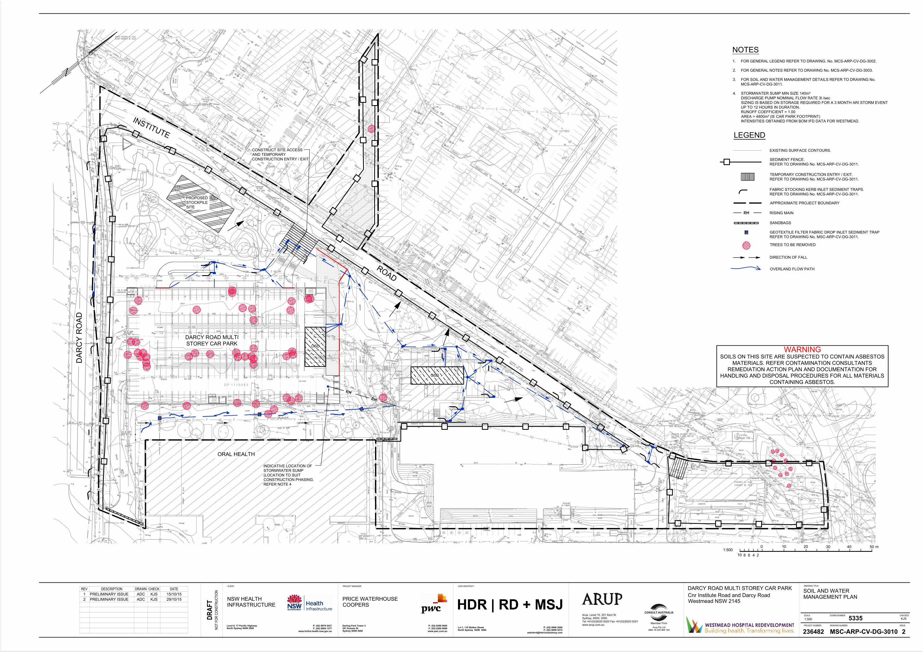
MSC-ARP-CV-DG-3010 Soil and Water Management Plan
MSC-ARP-CV-DG-3011 Soil and Water Management Details
MSC-ARP-CV-DG-3100 Demolition Plan Sheet 1 of 4
MSC-ARP-CV-DG-3101 Demolition Plan Sheet 2 of 4
MSC-ARP-CV-DG-3102 Demolition Plan Sheet 3 of 4
MSC-ARP-CV-DG-3103 Demolition Plan Sheet 4 of 4
MSC-ARP-CV-DG-3200 Roadworks and Drainage Plan Sheet 1 of 4
MSC-ARP-CV-DG-3201 Roadworks and Drainage Plan Sheet 2 of 4
MSC-ARP-CV-DG-3202 Roadworks and Drainage Plan Sheet 3 of 4

NSW Health Infrastructure Darcy Road Multi Storey Car ParkSSD - Civil Report
| Rev B | 29 October 2015 | Arup
Z:\SYD\PROJECTS\236000\236482-00 WESTMEAD HOSPITAL\WORK\INTERNAL\DESIGN\CIVIL\DARCY RD CP\REPORTS\MSC-ARP-CV-RT-0001[3].DOCX
Page 2
MSC-ARP-CV-DG-3203 Roadworks and Drainage Plan Sheet 4 of 4
MSC-ARP-CV-DG-3210 Roadworks Longitudinal Sections
MSC-ARP-CV-DG-3300 Drainage Longitudinal Sections
2 Geometric Design
The geometric design includes the internal access roads, modifications to the
external road networks, extension of Institute Road and bulk earthworks.
2.1 Internal Roads
Internal roads provide access from the surrounding road network to the car park.
Each road has been designed to grade away from the car park to direct stormwater
runoff away. At the tie-ins to the existing road network, dish drains are to be
provided along the alignment of the existing kerb.
2.2 External Roads
The external roadwork consists of the localised widening to Institute Road the site
entry/ exits and the extension of Institute Road to the east to tie in with the new
road being constructed during the early works. The road grading at the widening
of Institute Road is to be designed to match the existing road cross fall.
2.3 Retaining walls
Where feasible surrounding the MSCP, earthworks batters are to be provided in
lieu of retaining walls. However at several locations (ie lift lobby) earthworks
batters are not feasible and retaining walls are necessary and shall be provided in
the structural design for the car park.
Three external retaining walls are to be provided between the car park and the
Oral Health building. These retaining walls are required for the provision of a
stormwater overland flow path. These requirements are discussed in further detail
in Section 3.3. The retaining wall heights vary to a maximum of 1.6m.
The proposed at-grade car park is located adjacent to Car Park WH6 which is 2-
3m lower in elevation. Therefore a retaining wall is required at the interface
between the two car parks.
2.4 Earthworks
The earthworks for the site is being driven by the finished floor level of the car
parks and the access road designs to tie into the car park and existing road
network. Additional earthworks will be required to provide on-site detention of
stormwater runoff beneath the at-grade car park.

NSW Health Infrastructure Darcy Road Multi Storey Car ParkSSD - Civil Report
| Rev B | 29 October 2015 | Arup
Z:\SYD\PROJECTS\236000\236482-00 WESTMEAD HOSPITAL\WORK\INTERNAL\DESIGN\CIVIL\DARCY RD CP\REPORTS\MSC-ARP-CV-RT-0001[3].DOCX
Page 3
2.4.1 Contamination
Douglas Partners has undertaken studies and ground investigations at the site. It is
suspected that asbestos waste is present across the site (refer to Douglas Partners
Drawing No. C1, “Areas of Potential Environmental Concern Westmead Hospital
Redevelopment Hawkesbury Road, Westmead” for further details).
The earthworks design for the car park is influenced by the finished floor levels
and road tie in levels. Therefore there is limited scope to reduce the amount of
potential asbestos excavation in the vicinity of the car park. Where possible,
elsewhere on the site, including the access roads and landscaping, the design
levels have attempted to tie in to existing ground levels or minimise the depth of
excavation to limit the risk of exposing asbestos.
3 Stormwater Concept Plan
The stormwater drainage design addresses the capture of stormwater runoff from
the site, including the MSCP, at-grade car park, access roads and landscaping and
the discharge from site into the existing stormwater infrastructure. It also
addresses the water quality treatment, on-site detention (OSD) and potential for
flooding.
The stormwater drainage design of the MSCP is to be documented by the project
hydraulic engineer. The civil design includes an allowance for the capture and
discharge of the car park OSD tank and for a pumped discharge (if required) to
manage the limited stormwater entering Lower Ground Level as a result of water
borne on vehicles or similar.
The external civil drainage consists of:
• pit and pipe network and OSD for the at-grade car park and MSCP access
roads
• series of trench drains for the capture of surface runoff from pedestrian
footpaths
All stormwater pits and trench drains located within pedestrianised areas are to be
heelsafe. Similarly, those located within the roads and at-grade car park will be
bicycle safe.
All new stormwater pipes are to be minimum DN375 (with the exception of upvc
pipes discharging from trench drains).
Due to the grading of the site, the proposed pits located in the MSCP access roa
and the trench drains are at a lower elevation than the surrounding surface levels.
However this is consistent with the grading and drainage design of the existing at-
grade car park which also provides stormwater pits at a lower elevation to the
receiving network. During the detailed design, a hydraulic grade line (HGL)
analysis of the network will be carried out to check for network surcharge.
NSW Health Infrastructure Darcy Road Multi Storey Car ParkSSD - Civil Report
| Rev B | 29 October 2015 | Arup
Z:\SYD\PROJECTS\236000\236482-00 WESTMEAD HOSPITAL\WORK\INTERNAL\DESIGN\CIVIL\DARCY RD CP\REPORTS\MSC-ARP-CV-RT-0001[3].DOCX
Page 4
3.1 Water Quality
Section 3.3.6 of the Parramatta City Council Development Control Plan (DCP)
outlines the requirements for Water Sensitive Urban Design (WSUD) including
water quality targets. Table 2 summarises the pollutant reductions targets
specified in the DCP.
Table 2: Stormwater pollutant reduction targets
Pollutant Reduction Target*
Gross Pollutants (>5mm) 90%
Total Suspended Solids (TSS) 85%
Total Phosphorus (TP) 60%
Total Nitrogen (TN) 45%
Hydrocarbons, motor oils, oil and grease No visible flows up to 50% of the 1-year ARI peak
flow
*Note: Targets are reductions in pollutant loads relative to the same development without
treatment.
Water quality treatment for stormwater captured by the MSCP and at-grade car
park will need to be provided by a proprietary product outside of the MSCP
footprint.
At the current stage of design development, water quality modelling of the site has
not been undertaken to confirm the specifications for the treatment device/s. This
will be necessary in later stages of development to confirm compliance with the
reduction targets.
3.2 On-Site Detention
Council’s DCP also considers OSD as part of WSUD. The DCP specifies that
OSD is to be provided in accordance with the Upper Parramatta River Catchment
Trust (UPRCT) “On-Site Stormwater Detention Handbook” 4th edition,
December 2005. This document outlines UPRCT’s objectives for OSD as being:
• The primary objective is to not increase peak stormwater flows in any
downstream area in any event up to and including the 100 year average
recurrence interval (ARI) event (when comparing to 1999 conditions).
• The secondary objectives are to reduce post-development peak flows in the
1.5 year ARI event to as close as practical to natural levels and to integrate
OSD with other water quality measures.
Based on these objectives, the Handbook specifies control standards for Site
Reference Discharge (SRD) and Site Storage Requirements (SSR). Two rates are
provided for each of these (based on site area) to account for the 1.5 year and 100
year ARI events.
The SRD can be calculated as follows:
• 40 L/s/ha for the primary (lower) orifice outlet (SRDL) (for events up to 1.5
year ARI)

NSW Health Infrastructure Darcy Road Multi Storey Car ParkSSD - Civil Report
| Rev B | 29 October 2015 | Arup
Z:\SYD\PROJECTS\236000\236482-00 WESTMEAD HOSPITAL\WORK\INTERNAL\DESIGN\CIVIL\DARCY RD CP\REPORTS\MSC-ARP-CV-RT-0001[3].DOCX
Page 5
• 150 L/s/ha for the secondary (upper) orifice outlet (SRDU) (or moderate to
major storms).
Similarly the SSR can be calculated as follows (the SSR for the OSD storage is
partitioned into extended detention (lower) and flood detention (upper) storages):
• 455 m3/ha for overall (total) storage (SSRT)
• 300 m3/ha is the maximum SSR for the extended detention storage
• The difference between the total and extended detention storages is the flood
detention storage.
The site for the Darcy Road car park will consist of the MSCP, at-grade car park,
access roads and soft and hard landscaping.
Advice from Council is that the rates given in the UPRCT Handbook should be
applied to impermeable surfaces, while soft-landscaped areas should be designed
so as not to worsen conditions. With this in mind, storage will be provided for the
car parks and access roads. Soft-landscaped areas have been designed so as not to
interrupt overland flow paths or worsen conditions.
OSD for the MSCP will be provided within the car park footprint, and as such will
be designed and specified by the project’s hydraulic engineer based on the
requirements outlined in Table 3 (calculated for a car park area of 4,800m2). The
OSD for the at-grade car park will be provided in a below ground proprietary
storage chamber. The storage requirements for the at-grade car park are also
provided in Table 3 based upon a car park area of 1250m2.

NSW Health Infrastructure Darcy Road Multi Storey Car ParkSSD - Civil Report
| Rev B | 29 October 2015 | Arup
Z:\SYD\PROJECTS\236000\236482-00 WESTMEAD HOSPITAL\WORK\INTERNAL\DESIGN\CIVIL\DARCY RD CP\REPORTS\MSC-ARP-CV-RT-0001[3].DOCX
Page 6
Table 3: OSD design criteria
Design Criteria MSCP
Requirements
At-Grade Car
Park
Discharge
Site Reference Discharge,
Lower Orifice – SRDL
40 L/s/ha 19.2L/s 5L/s
Site Reference Discharge,
Upper Orifice – SRDU
150 L/s/ha 72L/s 19L/s
Storage
Site Storage Requirements
(Total) - SSRT
455m3/ha 220m3 57m3
Site Storage Requirements
(Extended Detention Storage)
300m3/ha 145m3 38m3
Site Storage Requirements
(Flood Detention Storage)
Balance of total
and extended
detention storage
75m3 19m3
The OSD tank within the MSCP will need to provide a minimum of 220m3
storage. A minimum volume is specified as there is potential for it to increase
depending upon the discharge and performance of the tank. Details of the tank
configuration are pending, however it is understood that the tank will be provided
within the MSCP between lower ground and ground floor levels. The finished
floor level of lower ground is 18.0mAHD. This is lower than the existing,
surrounding network’s surface levels. If a connection is to be made from the
MSCP OSD tank to this network, a HGL analysis will be required in subsequent
design stages to check the performance of the tank with respect to the influences
of high tailwater conditions. In the interim, the design which has been
documented provides for a new stormwater connection from the MSCP,
combining with the drainage from the at-grade car park and connecting into the
existing trunk stormwater network downstream of the site where the influences of
high tailwater conditions are less likely. HGL analysis will be required to confirm
hydraulic performance of the network.
OSD for the at-grade car park is to be provided in a proprietary OSD tank beneath
the car park surface. It is currently proposed to provide StormTech SC-310 or an
approved equivalent. To achieve a storage volume of 57m3, a minimum of 135
cells are required which can be achieved in a 9x15 cell arrangement. A minimum
volume is specified as it is subject to HGL analysis which may necessitate an
increase if high tailwater conditions are present on site.
NSW Health Infrastructure Darcy Road Multi Storey Car ParkSSD - Civil Report
| Rev B | 29 October 2015 | Arup
Z:\SYD\PROJECTS\236000\236482-00 WESTMEAD HOSPITAL\WORK\INTERNAL\DESIGN\CIVIL\DARCY RD CP\REPORTS\MSC-ARP-CV-RT-0001[3].DOCX
Page 7
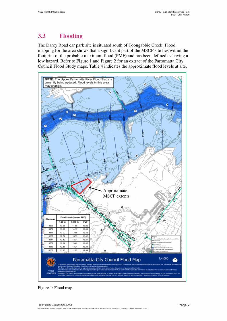
3.3 Flooding
The Darcy Road car park site is situated south of Toongabbie Creek. Flood
mapping for the area shows that a significant part of the MSCP site lies within the
footprint of the probable maximum flood (PMF) and has been defined as having a
low hazard. Refer to Figure 1 and Figure 2 for an extract of the Parramatta City
Council Flood Study maps. Table 4 indicates the approximate flood levels at site.
Figure 1: Flood map
Approximate
MSCP extents

NSW Health Infrastructure Darcy Road Multi Storey Car ParkSSD - Civil Report
| Rev B | 29 October 2015 | Arup
Z:\SYD\PROJECTS\236000\236482-00 WESTMEAD HOSPITAL\WORK\INTERNAL\DESIGN\CIVIL\DARCY RD CP\REPORTS\MSC-ARP-CV-RT-0001[3].DOCX
Page 8
Figure 2: Flood hazard map
Table 4: Flood levels (interpreted from Ch133556 of Parramatta City Council flood
hazard map provided in Figure 2)
ARI 20 Year 100 Year PMF
Flood level (mAHD) 13.68 14.55 18.96
Approximate
MSCP extents

NSW Health Infrastructure Darcy Road Multi Storey Car ParkSSD - Civil Report
| Rev B | 29 October 2015 | Arup
Z:\SYD\PROJECTS\236000\236482-00 WESTMEAD HOSPITAL\WORK\INTERNAL\DESIGN\CIVIL\DARCY RD CP\REPORTS\MSC-ARP-CV-RT-0001[3].DOCX
Page 9
The existing and proposed levels across the site are typically greater than
17.0mAHD which indicates that the site is located above the 100 year flood level.
Council defines “a low flood risk precinct is the area above the 100 year flood and
includes all area up to and including the probable maximum flood”. On this basis
the site is considered to be a low flood risk.
The “Parramatta Development Control Plan” (DCP), 2011 defines the planning
and development controls depending upon the location and type of development.
The DCP considers the landuse of a hospital as being “sensitive uses and
facilities” which considers developments unsuitable within PMF affected areas.
However, since the site being developed as a multi storey car park, it may also be
interpreted as a commercial or industrial car park. On this basis the DCP requires
that the following measures be implemented:
1. Car parking accommodating more than 3 vehicles must be protected from
inundation by floods equal to or greater than the 100 year ARI flood and
Ramp levels to be no lower than 0.5m above the 100 year ARI flood level.
2. The driveway providing access between the road and parking spaces shall
be as high as practical and generally rising in the egress direction.
The proposed MSCP complies with the above requirements as the finished floor
level (18.0mAHD) is located above 100 year ARI flood level (14.55mAHD) and
the access roads grade away from the lower ground level of the car park to the
road.
The majority of the proposed development within the site is within cut. Therefore
the development is not anticipated to have a negative impact on flooding due to
loss of flood storage.
An existing DN675 stormwater pipe traverses the site from west to east along the
southern edge of the MSCP. This pipe is being relocated as part of the project
works. The alignment of this pipe correlates with an overland flow for stormwater
runoff in excess of the pipe capacity. Preliminary calculations have determined
that the upstream catchment runoff in the 100 year ARI event is approximately
2.0m3/s. The pipe capacity (assuming flowing full and not under pressure) is
1.5m3/s. The balance of this, 0.5m3/s will be overland flow. The grading design
for the site makes allowance for retaining an overland flow path route between the
MSCP and the Oral Health building in a trapezoidal shaped channel. This channel
has a 2.5m base with 1:3 batter slopes. The Oral Health building has two sets of
fire stairs which impinge upon the grading of the overland flow path and a fire
access route is indicated in this location. To maintain this fire access route and
overcome the stairs impinging upon the overland flow path, retaining walls have
been provided around each set of stairs. A 1.8m wide level path has been provided
around the fire stairs for fire access. An additional retaining wall is required to the
north east corner of the Oral Health building. A similar 1.4m wide path has been
provided at this location for fire access. The design of these fire access routes
requires further coordination with respect to BCA compliance. It may be
necessary to physically separate the overland flow path from the fire access
routes. This may be achieved by providing a culvert for the overland flow path
and therefore providing a physical separation.

NSW Health Infrastructure Darcy Road Multi Storey Car ParkSSD - Civil Report
| Rev B | 29 October 2015 | Arup
Z:\SYD\PROJECTS\236000\236482-00 WESTMEAD HOSPITAL\WORK\INTERNAL\DESIGN\CIVIL\DARCY RD CP\REPORTS\MSC-ARP-CV-RT-0001[3].DOCX
Page 10
3.4 Climate Change
The design for the stormwater drainage is required to take into consideration the
implications of climate change. This is to include a sensitivity analysis as a result
of an increase in rainfall intensity (typically a 10% increase). The sensitivity
analysis will form the basis of assessing the impacts of climate change upon the
development. This may include amplifying the capacity of the proposed
stormwater network or the acceptance of a reduced level of service. The
implication of climate change upon main stream flooding is being addressed by
Advisian.
4 Erosion and Sediment Control
During construction, sources of risk to water quality if not managed include:
• Erosion of soil from disturbed areas
• Stockpiling of topsoil and vegetation
• Transportation of cut or fill materials
• General earthworks, including stripping of topsoil, excavation or raising
Impacts from inappropriate management of the construction site on water quality
could include:
• Increased sediment loads from exposed soil during rainfall events and dust
blown off site causing high sediment loads to be washed or deposited into
nearby creeks
• Increased sedimentation of downstream watercourses smothering aquatic
life and affecting the ecosystems of downstream sensitive waterways,
wetlands and floodplains.
• Increased levels of nutrients, metals and other pollutants, transported via
sediment to downstream water courses
• Chemical, heavy metal, oil and grease, and petroleum hydrocarbon spills
from construction machinery directly polluting downstream waterways.
• Siltation of pit and pipe networks reducing the conveyance capacity of the
network.
• Water borne transport of asbestos containing material.
Erosion and sediment control for the site has been provided in accordance with
Landcom’s “Soil and Construction Manual” (commonly known as the Blue
Book), Volume 1, March 2004. In accordance with Table 2.1 of the Blue Book, a
Soil and Water Management Plan has been prepared for the site due to the area of
disturbance being greater than 2,500m2.
Measures that have been adopted to minimise water quality impacts are indicated
on the erosion and sediment control plans which include:

NSW Health Infrastructure Darcy Road Multi Storey Car ParkSSD - Civil Report
| Rev B | 29 October 2015 | Arup
Z:\SYD\PROJECTS\236000\236482-00 WESTMEAD HOSPITAL\WORK\INTERNAL\DESIGN\CIVIL\DARCY RD CP\REPORTS\MSC-ARP-CV-RT-0001[3].DOCX
Page 11
• Implementation of appropriate controls in place before the removal of
topsoil and commencement of earthworks
• Onsite water management using sediment traps, silt fencing etc.
• Appropriate construction methodology for cutting and embankment
erosion management
• Stockpile management.
As the annual volume of soil loss for the site is less than 150m3, a sediment basin
is not required as stated in Note 54 of Appendix M of the Blue Book.
A summary of the method for selecting parameters is included below:
• R – Rainfall Erosivity – 2583 – Calculated using the equation R =
164.74.(1.1177)S.S0.6444 provided in Appendix A2 of the Blue Book where
S is the 2-year, 6 hour ARI rainfall event (10.9mm/hr).
• K – Soil Erodibility Factor – 0.05 – this needs to be confirmed with soil
testing for the site. In the absence of any data, this value has been adopted
based on the range provided in the Blue Book (0.005 to 0.075).
• LS – Length Slope Factor –This factor depends on the terrain gradient and
slope length. The site is relatively flat with most gradients being less than
1%. A maximum slope length of 40m has been adopted.
• P – Erosion Control Practice Factor – 1.3 – based on a compacted and
smooth surface condition from Table A2 of the Blue Book.
• C – Cover Factor – 1.0 – assumes there is no grass cover.
• 5-day 85th percentile rainfall depth – 33.1mm – based on the date for
Parramatta North from Figure 6.5 of the Blue Book.
• Cv – volumetric runoff coefficient – 0.64 – based on a soil with high
runoff potential from Table F2 of Appendix F3 of the Blue Book.
5 Existing Services Impact Assessment
Numerous existing utility services traverse the site. This includes utilities
servicing the existing at-grade car park and cooling tower building which will be
abandoned as part of the development. However there are also a number of
existing services traversing the site which provide connections to the wider
network which will need to be maintained (whether in their current location or in
a relocated position). These services are described in the following sections.
5.1 Stormwater
A DN675 stormwater pipe originating to the southwest side of Oral Health
building, traverses the site from west to east along the alignment of the southern
edge of the proposed multi storey car park. The manhole and pipes under the

NSW Health Infrastructure Darcy Road Multi Storey Car ParkSSD - Civil Report
| Rev B | 29 October 2015 | Arup
Z:\SYD\PROJECTS\236000\236482-00 WESTMEAD HOSPITAL\WORK\INTERNAL\DESIGN\CIVIL\DARCY RD CP\REPORTS\MSC-ARP-CV-RT-0001[3].DOCX
Page 12
proposed wall will need to be relocated. This location is preferably between the
multi storey car park and Oral Health building
The existing at-grade car park stormwater drainage network will need to be
demolished or capped and abandoned.
5.2 Sewer
There is an existing Sydney Water DN300 salt glazed wear sewer pipe located to
the north of the proposed multi storey car park. The proposed road works will
traverse the existing sewer pipe. The protection of this pipe (eg concrete
encasement may be necessary depending upon the depth of cover achieved to the
service.
5.3 Water
An existing DN200 PVC-U Sydney Water pipe runs along the east side of Darcy
Road. Whilst this service should not be affected by the proposed car park
development, may require concrete encasement for the length of service beneath
the vehicle access crossing. Confirmation to be obtained during detailed design.
An existing fire water supply pipe passes between the multi storey car park and
the Oral Health building. This pipe is to be retained as a result of the development,
and will be detailed by the hydraulic engineer.
5.4 Electrical
There are underground electrical cables under the existing car park which are
understood to supply power to the existing lighting. These may be abandoned as a
result of the development. This is to be documented by the electrical engineer.
There are existing Endeavour Energy underground cables along the east side of
Darcy Road. This electrical cable should not be affected by the proposed works
with the exception of the potential for localised lowering under the vehicle access
road to the site.
Electrical cables are located on the southern side of Institute Road. This includes
the power supply to the street lighting. The location of an existing light pole
clashes with the proposed vehicle access and will require relocating. Due to the
localised widening of Institute Road, the electrical cables will either require
relocating to be behind the proposed kerb line or to be protected.
5.5 Telecommunications
There is an existing DN100 Telstra PVC conduit containing Telstra and Uecomm
optic fibre which is located in the southern verge of Institute Road. The proposed
road widening and drive way along Institute Road will traverse the existing optic
fibre. The protection or relocation of the conduit and services will be required.

NSW Health Infrastructure Darcy Road Multi Storey Car ParkSSD - Civil Report
| Rev B | 29 October 2015 | Arup
Z:\SYD\PROJECTS\236000\236482-00 WESTMEAD HOSPITAL\WORK\INTERNAL\DESIGN\CIVIL\DARCY RD CP\REPORTS\MSC-ARP-CV-RT-0001[3].DOCX
Page 13
An existing Optus cable runs along the east side of Darcy Road. This cable should
not be affected by the proposed road works with the exception of the potential for
localised lowering under the vehicle access road to the site.
5.6 Gas
There are no existing gas services within the proposed site.

Appendix A
Civil Drawings

Project No Drawing No
Issue
Level 10, 201 Kent Street
SYDNEY NSW 2000
Telephone (02) 9320 9320 Facsimile (02) 9320 9321
Consulting Engineers
DARCY ROAD MULTI STOREY
CAR PARK
Civil Works
October 2015
MSC-ARP-CV-DG-3001 2236482

R
O
A
D
IN
S
T
IT
U
T
E
D
P
1
1
1
9
5
8
3
1
0
0
R
O
A
D
IN
S
T
IT
U
T
E
Y
H
A
W
K
E
S
B
U
R
Y
R
E
D
B
A
N
K
R
O
A
D
B
I
T
U
M
E
N
R
O
A
D
R
O
A
D
R
O
A
D
R
O
A
D
R
E
D
B
A
N
K
N
E
W
P
E
D
E
S
T
R
I
A
N
F
O
O
T
P
A
T
H
D
A
R
C
Y
R
O
A
D
Ø450
KR
1
VC
DRAWING SCHEDULE
REFERENCE DRAWINGS
PARRAMATTA CITY COUNCIL (PCC) STANDARD DRAWINGS
(REFER TO SPECIFICATION)
LEGEND
DRAWING No.
TITLE
ISSUE
DRAWING No. TITLE
PROPOSED
FUTURE
BOUNDARY AND KERB ALIGNMENTS
DRIVEWAY, PATHWAY OR CYCLEWAY
ES
DC
MK
K&G
BB
TB
GENERAL
MSC-ARP-CV-DG-3001
MSC-ARP-CV-DG-3002
MSC-ARP-CV-DG-3003
COVER SHEET
LOCALITY PLAN, DRAWING SCHEDULE AND LEGEND
GENERAL NOTES
DS1
DS2
DS3
DS4
DS5
KERBS AND LAYBACKS
ROOFWATER OUTLET
FOOTPATH
KERB RAMP
DISH DRAIN CROSSING DETAIL
DS6
DS8
DS9
DS10
DS11B
DS21
DS23
DS24
DS25
DS25
DS26
TYPICAL CYCLEWAY/SHARED PATHWAY
STANDARD VEHICULAR CROSSING
HEAVY DUTY VEHICULAR CROSSING
VEHICULAR CROSSING PROFILES
SIGN SUPPORT POST
STANDARD KERB INLET PIT (ON GRADE)
STANDARD SURCHARGE PIT
GRATED SAG PIT USING PRECAST LINTEL
SURFACE INLET PIT FOR FOOTPATHS
SURFACE INLET PIT FOR OPEN SPACE AREAS
STANDARD JUNCTION PIT
HEAVY DUTY JUNCTION PIT
TWIN GRATED GULLY PIT WITH EXTENDED KERB INLET
SUBSOIL DRAINAGE DETAILS
HEADWALLS FOR CULVERTS UP TO 900 DIAMETER
STANDARD FOR INSTALLATION OF PIPELINES AND
RESTORATION OF TRENCHES
DS26
DS31
DS33
DS36
DS37
TREE PROTECTION TIMBER HOARDINGDS43
PRJECT BOUNDARY
EASEMENT BOUNDARY
KERB AND GUTTER TO PCC STD DRG No DS1
EDGE STRIP TO PCC STD DRG No DS1
MEDIAN KERB TO PCC STD DRG No DS1
DISH CROSSING TO PCC STD DRG No DS1
HEAVY DUTY LAYBACK TO PCC STD DRG No DS1
VEHICULAR CROSSING TO PCC STD DRG No DS1
PEDESTRIAN RAMPS TO PCC STD DRG No DS4
DOUBLE BARRIER LINE (BB)
HOLDING LINE (TB)
PAVERS
KERB RETURN No. 1
STREET NAME SIGN & POST TO PCC STD DRG No DS11
STREET SIGN & POST TO PCC STD DRG No DS11
DRAINAGE CATCHMENT BOUNDARY
Ø100 SUBSOIL DRAINAGE LINE TO PCC STD DRG No DS33
Ø450 STORMWATER DRAINAGE PIPELINE
STORMWATER PIT No 6 - LINE No 301
STANDARD GRATED KERB INLET PIT TO PCC STD DRG No DS21
STANDARD GRATED SAG PIT TO PCC STD DRG No DS24
STANDARD SURFACE INLET GRATED PIT TO PCC STD DRG NO DS25
STANDARD JUNCTION PIT TO PCC STD DRG NO DS26
TRENCH DRAIN
SS
HDL
BOUNDARY
DRIVEWAY, PATHWAY OR CYCLEWAY
TOP OF BATTER
BOTTOM OF BATTER
SPOT LEVEL
KERB AND GUTTER
DISHED CROSSING
STORMWATER
STORMWATER PIT
SEWERAGE
SEWER MAINTENANCE HOLE
SEWERAGE - TRADE WASTE
SEWER TUNNEL
WATER SUPPLY
STOP VALVE HYDRANT
WATER FIRE SUPPLY
TELSTRA
TELSTRA PIT
ELECTRICITY
ELECTRICITY POLE
TELECOMMUNICATION
GAS
TREE
EXISTING
SCALE 1:2 500
LOCALITY PLAN
WESTMEAD
NORTHMEAD
I
N
S
T
I
T
U
T
E
D
A
R
C
Y
M
O
N
S
R
E
D
B
A
N
K
R
D
R
D
R
D
R
D
H
A
W
K
E
S
B
U
R
Y
R
D
TO
ON
GA
BB
IE
C
R
E
E
K
ROADWORKS
MSC-ARP-CV-DG-3200
MSC-ARP-CV-DG-3201
MSC-ARP-CV-DG-3203
MSC-ARP-CV-DG-3204
ROADWORKS AND DRAINAGE PLAN SHEET 1 OF 4
ROADWORKS AND DRAINAGE PLAN SHEET 2 OF 4
ROADWORKS AND DRAINAGE PLAN SHEET 3 OF 4
ROADWORKS AND DRAINAGE PLAN SHEET 4 OF 4
2
2
1
2
2
1
1
SOIL AND WATER
MSC-ARP-CV-DG-3010 SOIL AND WATER MANAGEMENT PLAN2
WESTMEAD
HOSPITAL
N
E
W
P
E
D
E
S
T
R
I
A
N
F
O
O
T
P
A
T
H
SITE OF
WORKS
MSC-ARP-CV-DG-3011 SOIL AND WATER MANAGEMENT DETAILS1
DEMOLITION WORKS
MSC-ARP-CV-DG-3100
MSC-ARP-CV-DG-3101
MSC-ARP-CV-DG-3102
MSC-ARP-CV-DG-3103
DEMOLITION PLAN SHEET 1 OF 4
DEMOLITION PLAN SHEET 2 OF 4
DEMOLITION PLAN SHEET 3 OF 4
DEMOLITION PLAN SHEET 4 OF 4
2
2
1
1
MSC-ARP-CV-DG-3210 ROADWORKS LONGITUDINAL SECTIONS2
MULTI STOREY CAR PARK
DRAINAGE
MSC-ARP-CV-DG-3300 DRAINAGE LONGITUDINAL SECTIONS2
"A"
"B"
S.S.M. 51282
RL 15.579
B.M. ON KERB
RL 17.65
S.S.M. 87246
RL 22.037
826.7
90
83°18'15"
SCALE:
DRAWING TITLE:
DRAWING NUMBER:
CHECKED:
PROJECT NUMBER: ISSUE:
NOT
FOR
CONS
TRUC
TION
DOHRS NUMBER:
LEAD ARCHITECT:
Lvl 1, 110 Walker Street
North Sydney NSW 2060
P: (02) 9956 2666
F: (02) 9959 3015
PROJECT MANAGER:
Darling Park Tower 2
201 Sussex St
Sydney NSW 2000
P: (02) 8266 0000
www.pwc.com.au
F: (02) 8266 9999
CLIENT:
Level 6, 77 Pacific Highway
North Sydney NSW 2060
P: (02) 9978 5427
www.hinfra.health.nsw.gov.au
F: (02) 8904 1377
DARCY ROAD MULTI STOREY CAR PARK
Cnr Institute Road and Darcy Road
Westmead NSW 2145
PRICE WATERHOUSE
COOPERS
NSW HEALTH
INFRASTRUCTURE
REV DESCRIPTION DRAWN CHECK DATE
Arup Pty Ltd
ABN 18 000 966 165
CONSULT AUSTRALIA
Member Firm
5335
NOT
FOR
CONS
TRUC
TION
MSC-ARP-CV-DG-3002 2236482
AS SHOWN
LOCALITY PLAN,
DRAWING SCHEDULE AND
LEGEND
PRELIMINARY ISSUE
KJS
PRELIMINARY ISSUE
1
2
ADC
ADC
KJS
KJS
15/10/15
29/10/15
Arup, Level 10, 201 Kent St
Sydney, NSW, 2000
Tel +61(02)9320 9320 Fax +61(02)9320 9321
www.arup.com.au
0
1:2500
50
50100 150 200 250 m

ALL BEARINGS AND DISTANCES BY SURVEY.
ALL SURVEY FOR THIS DESIGN IS SUPPLIED BY:
LTS LOCKLEY
SUITE 1, LEVEL 1, 810 PACIFIC HIGHWAY, GORDON NSW 2072
PHONE 1300 587 000 FAX 02 9499 7760
ORIGIN OF LEVELS
S.S.M 156523 RL 16.485 (A.H.D.)
AZIMUTH
S.S.M. 156523 (ORIGIN) - S.S.M. 87246 (BY SURVEY) 83°18'15" 826.790
MGA COORDINATES S.S.M. 156523 (ORIGIN) - EAST 313 352.533,
NORTH 6 257 848.561. NOTE THIS PLAN IS ON MGA COORDINATES BASED ON
THE ABOVE AZIMUTH.
WORKS SHALL BE UNDERTAKEN IN THE FOLLOWING SEQUENCE:
ES1
ES2
INSTALL EROSION AND SEDIMENT CONTROLS.(A)
(B)
(C)
(D)
(E)
UNDERTAKE REMAINING SITE WORKS IN ACCORDANCE WITH THE
ENGINEERING PLANS.
REMOVE SOIL AND WATER MANAGEMENT WORKS NOT REQUIRED FOR
OTHER STAGES OF CONSTRUCTION ONCE UPSTREAM SURFACES ARE
STABILISED TO THE SATISFACTION OF THE SUPERINTENDENT.
TOPSOIL AND REHABILITATE BULK EARTHWORK AREAS IMMEDIATELY
UPON COMPLETION.
ALL EROSION AND SEDIMENT CONTROL MEASURES TO BE IN
ACCORDANCE WITH LANDCOM "SOILS AND CONSTRUCTION MANUAL
VOLUME 1, MARCH 2004"
EC1
* A RECOMMENDED LIST OF PLANT SPECIES FOR TEMPORARY COVER IS :
- JAPANESE MILLET 10kg/ha
- OATS (RYECORN) 30kg/ha
GYPSUM AND MULTIGROW/ ENRICH FERTILIZER AT RATES TO BE DETERMINED
BY SUBSOIL AND TOPSOIL TESTING.
* A RECOMMENDED LIST OF PLANT SPECIES FOR PERMANENT GRASSING IS :
- DURATURF PARK BLEND (WRIGHT STEPHENSON SEED MIX) + COVER CROP
- TACKIFYING AGENT (CURASOL OR SIMILAR)
EC2
- THOROUGHBRED TURF TALL FESCUE 15kg/ha
- JAPANESE MILLET 25kg/ha
- OATS (RYECORN) 25kg/ha
SPRING
SUMMER
AUTUMN
WINTER
- OATS (RYECORN) 10kg/ha
- JAPANESE MILLET 10kg/ha
- PERENNIAL RYEGRASS 37kg/ha
- CHEWINGS FESCUE 5kg/ha
- UNMULLED COUCH 4kg/ha
CONTROLS AFFECTED BY WORKS ARE TO BE RE-ESTABLISHED PRIOR TO
THE COMPLETION OF EACH DAYS WORK.
THE CONTRACTOR IS TO STABILISE TOPSOIL STOCKPILE AND BARE AREAS
AS SOON AS THEY REACH FINAL LEVELS. STABILISATION TO BE BY
HYDROSEEDING OR OTHER METHOD APPROVED BY SUPERINTENDENT. ALL
SEEDED AREAS TO BE WATERED TWICE WEEKLY UNTIL GRASS IS
ESTABLISHED OR COVERED WITH BITUMEN STRAW MULCH. SEED MIXTURE
FOR FOOTWAYS AND EMBANKMENTS TO BE IN ACCORDANCE WITH THE
FOLLOWING:
EC3
EC4
EC5
EC6
WHERE SURFACE SLOPES ARE MORE THAN 6H:1V BITUMEN STRAW MULCH
SHALL BE APPLIED AFTER SEEDING AT THE FOLLOWING RATES.
- MULCH 0.5kg/m²
- BITUMEN EMULSION 0.25 l/m² (50% WATER, 50% SLOW
BREAKING ANIONIC EMULSION MIX).
DUST CONTROL MEASURES SHALL BE IMPLEMENTED CONTINUOUSLY
DURING CONSTRUCTION WORKS TO THE SATISFACTION OF THE
SUPERINTENDENT.
TOPSOIL SHALL BE RESPREAD AND STABILISED AS SOON AS
POSSIBLE. DISTURBED AREAS SHALL BE LEFT WITH A SCARIFIED
SURFACE TO ENCOURAGE WATER INFILTRATION AND ASSIST KEYING IN
TOPSOIL.
THE CONTRACTOR SHALL TEMPORARILY REHABILITATE ANY DISTURBED
AREAS WITHIN 14 DAYS. WHERE FINAL SHAPING HAS OCCURRED THE
CONTRACTOR SHALL PROVIDE FINAL REHABILITATION WITHIN 7 DAYS.
SC3
SC4
SC7
SEDIMENT TRAPS ARE TO BE MAINTAINED SUCH THAT:
(A)
(B)
SC8
MATERIALS ARE REPLACED OR REPAIRED AS REQUIRED TO ENSURE
SERVICEABILITY OF BOTH THE ELEMENT AND THE TRAP.
SEDIMENT IS REMOVED SUCH THAT NO LESS THAN 70% OF THE DESIGN
CAPACITY REMAINS AT ANY ONE TIME.
PERMANENT DRAINAGE STRUCTURES INCLUDING: PIPES, PITS ARE TO
BE HANDED OVER IN A CLEAN CONDITION AT THE COMPLETION OF THE
CONTRACT MAINTENANCE PERIOD.
THE CONTRACTOR SHALL PROVIDE A 0.4m WIDE TURF STRIP BEHIND ALL
KERB AND GUTTER AT COMPLETION OF FOOTPATH FORMATION AND 1.0m
WIDE AROUND ALL SURFACE INLET PITS.
THE CONTRACTOR SHALL AT ALL TIMES RESTRICT CONSTRUCTION
EQUIPMENT MOVEMENT TO THE ESSENTIAL CONSTRUCTION AREAS.
THE CONTRACTOR SHALL NOT EXTEND LAND DISTURBANCE BEYOND
2m FROM THE EDGE OF ANY ESSENTIAL CONSTRUCTION ACTIVITY.
SC12
SC10
SC11
AN ACCESS POINT TO ALLOW MACHINE ENTRY / EXIT ARE TO INCLUDE A
ROUNDED EARTH MOUND 0.3m HIGH WITH 10H:1V BATTERS.
STRIP TOPSOIL OVER THE SITE TO AN AVERAGE DEPTH OF 100mm
UNLESS OTHERWISE APPROVED BY THE SUPERINTENDENT. TOP SOIL
STOCKPILES SHALL NOT EXCEED 2m IN HEIGHT AND BATTER SLOPES
TO BE 3H:1V MAXIMUM.
STRIP AND STOCKPILE TOPSOIL AND CARRY OUT ALL BULK EARTHWORKS.
EW6
EW7
G4
G5
G6
G7
G1
ROADWORKS GENERAL
ALL RUBBISH, BUILDINGS, SHEDS, FENCES, AND POWER POLES ARE
TO BE REMOVED IN ACCORDANCE WITH THE SPECIFICATION.
NO WORK TO BE CARRIED OUT ON ADJOINING PROPERTIES WITHOUT
THE WRITTEN PERMISSION FROM THE OWNER.
VEHICULAR ACCESS AND ALL SERVICES ARE TO BE MAINTAINED AT
ALL TIMES TO AREAS AFFECTED BY CONSTRUCTION.
R4
R3
R2
R1
ROADWORKS
PAVEMENT DEPTHS SHOWN ON CROSS SECTIONS ARE FOR DESIGN
PURPOSE ONLY. ALL DEPTHS TO BE CONFIRMED FOLLOWING INSITU
SUBGRADE CBR TESTING DURING CONSTRUCTION.
SUBSOIL DRAINS TO BE CONSTRUCTED AT BACK OF ALL KERBS
LOCATED IN CUT AND ON THE HIGH SIDE OF ALL ROADS, AS SHOWN
ON DRAWINGS OR AS DIRECTED BY THE SUPERINTENDENT.
R5
R6
R7
PROPOSED SERVICES CROSSING EXISTING ROADS SHALL BE THRUST
BORED UNDER THE ROAD SO AS NOT TO DAMAGE THE EXISTING
SURFACE.
R8
R11
R12
R10
R9
NO TREES TO BE REMOVED OTHER THAN THOSE AFFECTED BY THE
WORKS. ALL DEAD TREES SHALL BE REMOVED.
R13 TRANSITION KERB FROM KO TO K&G AT KERB RETURN T.P OVER A
LENGTH OF 1m.
SUBGRADE, SUBBASE AND BASE COURSES ARE TO BE COMPACTED TO THE
REQUIREMENTS OF THE GEOTECHNICAL REPORT.
SUBSOIL FLUSHING POINTS TO BE CONSTRUCTED IN ACCORDANCE WITH
PCC STD DRG No. DS33 REQUIREMENTS AND TO BE LOCATED AS DIRECTED.
ALL VEHICULAR CROSSINGS TO BE LOCATED MINIMUM 1.0m OFF SIDE
BOUNDARIES. LAYBACK TO HAVE A MINIMUM 1.0m CLEARANCE FROM POWER
AND LIGHT POLES, STORMWATER DRAINAGE PITS AND 6.0m CLEARANCE FROM
KERB RETURN TANGENT POINTS.
ALL BATTERS ARE TO BE SCARIFIED TO ASSIST WITH ADHESION OF TOPSOIL
TO BATTER FACE IN ACCORDANCE WITH THE SPECIFICATION.
PROVIDE 150mm TOPSOIL WITH GRASS COUCH TURF ON FOOTWAYS AND ALL
OTHER AREAS DISTURBED DURING CONSTRUCTION. A 0.4m WIDE,
CONTINUOUS STRIP OF COUCH GRASS SHALL BE PLACED BEHIND THE BACK
OF ALL KERBS IMMEDIATELY AFTER THE COMPLETION OF THE FOOTPATH
GRADING, MAINTAINED AND REPLACED AS REQUIRED DURING THE
MAINTENANCE PERIOD.
GUTTER SLOTS ARE TO BE PROVIDED AT REGULAR INTERVALS AND AT
PITS (ONLY WHERE TEMPORARY SEAL FINISHES BELOW LIP OF GUTTER).
SERVICES SHOWN ON THESE PLANS ARE LOCATED FROM INFORMATION
SUPPLIED BY THE RELEVANT AUTHORITIES AND FIELD INVESTIGATIONS
AND ARE NOT GUARANTEED COMPLETE OR CORRECT. ALL SERVICE
LOCATIONS ARE TO BE VERIFIED BY THE CONTRACTOR PRIOR TO
CONSTRUCTION.
IN 150mm KERB & GUTTER ONLY MODIFY KERB FOR FUTURE VEHICULAR
CROSSING WITH A LAYBACK WIDTH OF 4.5m TO SUIT 3.5m DRIVEWAY.
VEHICULAR CROSSING TO BE IN ACCORDANCE WITH PCC STD DRG No
DS1 WHERE SHOWN ONLY.
THE CONTRACTOR SHALL OBTAIN ALL LEVELS FROM ESTABLISHED
BENCH MARKS ONLY AS SUPPLIED BY THE APPOINTED SURVEYORS.
SERVICES CONDUITS TO BE PLACED AS DIRECTED FOR ENDEAVOR
ENERGY, NBN CO , JEMENA AND AS REQUIRED BY THE SYDNEY WATER
CORPORATION AND IDENTIFIED AT EACH KERB CROSSING WITH A
BRASS KERB MARKER NOTING EACH SERVICE TYPE.
D1
D2
DRAINAGE
D5
D4
D3
D6
D8
D7
D9
D11
D12
EROSION AND SEDIMENT
EROSION CONTROL MEASURES
SEDIMENT CONTROL MEASURES
THE CONTRACTOR SHALL MAINTAIN A LOG BOOK DETAILING
- RECORDS OF ALL RAINFALL
- CONDITION OF SOIL AND WATER MANAGEMENT STRUCTURES
- ANY ADDITIONAL REMEDIAL WORKS REQUIRED
THE LOG BOOK SHALL BE MAINTAINED ON A DAILY BASIS AND BE MADE
AVAILABLE TO ANY AUTHORISED PERSON UPON REQUEST. THE ORIGINAL
LOG BOOK SHALL BE ISSUED TO THE PROJECT MANAGER AT THE
COMPLETION OF THE WORKS.
EARTHWORKS
EARTHWORKS TO BE CARRIED OUT TO THE SATISFACTION OF THE
SUPERINTENDENT. UNSOUND MATERIALS NOT IN ACCORDANCE WITH THE
SPECIFICATION ARE TO BE REMOVED FROM ROADS AND BUILDING AREAS
PRIOR TO FILLING. ALL TESTING OF EARTHWORKS SHALL BE UNDERTAKEN
BY THE PRINCIPAL APPOINTED GEOTECHNICAL TESTING AUTHORITY.
WHERE THE SLOPE OF THE NATURAL SURFACE EXCEEDS ONE IN FOUR
(1:4), BENCHES ARE TO BE CUT TO PREVENT SLIPPING OF THE
PLACED FILL MATERIAL AS REQUIRED BY THE SUPERINTENDENT.
ALL SPOIL TO BE DISPOSED OF OFF SITE TO AN APPROVED DISPOSAL SITE.
ALL TOPSOIL TO BE STRIPPED AND STOCKPILED ONSITE FOR LATER USE.
THE CONTROL TESTING OF EARTHWORKS BY THE PRINCIPAL APPOINTED
GEOTECHNICAL TESTING AUTHORITY SHALL BE IN ACCORDANCE WITH THE
GUIDELINES IN AS 3798-2007. WHERE IT IS PROPOSED TO USE TEST METHOD
AS 1289.5.8.1-2007 TO DETERMINE THE FIELD DENSITY OF SOIL, A NUCLEAR
SURFACE MOISTURE-DENSITY GAUGE IN THE DIRECT TRANSMISSION MODE
OF OPERATION SHALL BE USED TO CONFIRM THE RESULTS, AS DIRECTED BY
THE SUPERINTENDENT. THE GEOTECHNICAL TESTING AUTHORITY SHALL
HAVE A LEVEL 2 RESPONSIBILITY AS DEFINED IN SECTION 8.3 AS 3798-2007,
AND AT THE END OF THE WORKS SHALL CERTIFY IN A WRITTEN REPORT
THAT THE EARTHWORKS COMPLY WITH THE REQUIREMENTS OF THE
SPECIFICATION AND DRAWINGS.
AT THE TOP OF ALL EXCAVATED BATTERS OVER 1.5m HIGH PROVIDE A
BARRIER FENCE.
EW1
EW2
EW3
EW5
MODIFY KERB FOR FUTURE FOOTPATH CROSSINGS IN ACCORDANCE WITH
PCC STD DRG No DS4 WHERE FUTURE FOOTPATHS ARE SHOWN.
G2
ALL KERB INLETS PITS (ON GRADE) TO BE BENCHED AND STREAMLINED,
PITS OVER 1.2m IN DEPTH TO BE PROVIDED WITH STEP IRONS AND
REINFORCED IN ACCORDANCE WITH PARRAMATTA CITY COUNCIL STD DRG
No DS21.
CONCRETE TO HAVE A MINIMUM COMPRESSIVE STRENGTH OF 32MPa AT 28
DAYS U.N.O.
ALL GRATED SAG PITS TO BE IN ACCORDANCE WITH PARRAMATTA CITY
COUNCIL DRG No DS24.
LINTEL LENGTH SHOWN ON SECTIONS INDICATES LENGTH OF CLEAR
OPENING.
ALL STANDARD SURCHARGE PITS TO BE IN ACCORDANCE WITH
PARRAMATTA CITY COUNCIL STD DRG No DS23.
ALL SURFACE INLET PITS TO BE IN ACCORDANCE WITH PARRAMATTA CITY
COUNCIL STD DRG No DS25.
ALL STORMWATER DRAINAGE JUNCTION PITS TO BE IN ACCORDANCE WITH
PARRAMATTA CITY COUNCIL STD DRG No DS26.
ALL LONGITUDINAL PIPELINES IN ROADS ARE TO BE LOCATED UNDER
KERBS AND GUTTERS AND TO BE BACKFILLED WITH WASHED RIVER SAND,
A 3.0 m LENGTH OF SUBSOIL DRAIN WRAPPED IN GEOFABRIC IS TO BE
PROVIDED TO THE UPSTREAM SIDE OF PITS ON ALL INCOMING LINES
UNLESS NOTED OTHERWISE.
ALL REINFORCED CONCRETE PIPES (RCP) OR FIBRE REINFORCED
CONCRETE PIPES (FRCP) TO BE CLASS 3 RUBBER RING JOINTED (RRJ)
UNLESS NOTED OTHERWISE.
STRUCTURAL CERTIFICATION IS REQUIRED FOR CONSTRUCTION OF MAJOR
AND NON STANDARD STORMWATER DRAINAGE STRUCTURES. THE
CONTRACTOR TO ARRANGE FOR A HOLD POINT FOR CONSTRUCTION
INSPECTIONS WITH A SUITABLY QUALIFIED ENGINEER AS APPOINTED BY
THE PRINCIPAL TO PROVIDE IN WRITING STRUCTURAL CERTIFICATE AT
COMPLETION OF WORKS.
SUBSOIL DRAINS TO BE PROVIDED UNDER ALL KERBS WITHOUT DRAINLINES
BELOW IN ACCORDANCE WITH PARRAMATTA CITY COUNCIL STD DRG No
DS33.
SURVEY
GENERAL NOTES
S1
S4
S2
S3
SC1 DURING EARTHWORKS,CARPARK WORKS, ROADWORKS, TEMPORARY
DIVERSION BANKS SHOULD BE CONSTRUCTED TO LIMIT SLOPE LENGTH,
WHERE POSSIBLE, IN ACCORDANCE WITH THE FOLLOWING:
SC2
RECOMMENDED MAXIMUM SPACING BETWEEN CROSS BANKS ON ALL ROADS.
MAXIMUM SPACING (m)
150
100
70
50
16
ALL STORMWATER PITS TO BE COVERED OR DROP INLET SEDIMENT
TRAPS PROVIDED IN ACCORDANCE WITH DRAWING No. MSC-ARP-CV-DG-3011
KERB INLET SEDIMENT TRAPS ARE TO BE INSTALLED AFTER
COMPLETION OF PAVING.
SLOPE
0 TO 1%
1 TO 3%
3 TO 5%
5 TO 10%
10 TO 17%
SC5
SC6
SC9
ALL TREES OTHER THAN THOSE IDENTIFIED FOR REMOVAL SHALL BE
RETAINED UNLESS APPROVED FOR REMOVAL BY SUPERINTENDENT.
FOLLOWING COMPLETION AND RESTORATION OF SITE. REMOVE ALL
MATERIALS AND FILL DIVERSION DRAINS, WATERWAYS AND SEDIMENT TRAPS
COMPACT IN ACCORDANCE WITH SPECIFICATION. TO MATCH LEVELS OF THE
PREVIOUSLY COMPLETED WORKS. PROVIDE 150mm TOPSOIL AND
HYDROSEED.
"NO TRAFFIC AREA" TO BE ENCLOSED WITH " BARRICADE WEBBING" FENCE
TO MAINTAIN EXISTING PASTURE DOWNSLOPE FROM SEDIMENT CONTROL -
LEVEL SPREADER. UNDER NO CIRCUMSTANCES SHALL THE CONTRACTOR
DISTURB ANY AREAS OUTSIDE THE CATCHMENT AREA.
SC13 THE CONTRACTOR SHALL PROVIDE CATCH DRAINS AT THE BOTTOM OF ALL
BATTERS AND DIVERT THE CATCH DRAINS AND ANY TAIL OUT DRAINS TO
DRAIN TO THE NEAREST STORMWATER PIT.
EW4 AN AREA CLASSIFICATION REPORT IN ACCORDANCE WITH AS 2870-2011
AND CERTIFIED BY THE GEOTECHNICAL TESTING AUTHORITY, SHALL BE
PROVIDED BY THE PRINCIPAL'S APPOINTED GEOTECHNICAL TESTING
AUTHORITY PRIOR TO THE RELEASE OF THE AREA FOR BUILDING.
D10 PRIOR TO THE FINAL INSPECTION A CCTV INSPECTION AND REPORT IS TO
BE UNDERTAKEN FOR ALL STORMWATER PIPES AND CULVERTS THAT ARE
PART OF THE DRAINAGE SYSTEM.
D13 FOR EXISTING DRAINAGE TO BE DEMOLISHED REFER DRAWING No.
MSC-ARP-CV-DG-3100 AND 3101.
G3 ALL REMOVING, DIVERSION AND PROTECTION WORKS RELATED TO
EXISTING SERVICES NEED TO BE VERIFIED AND APPROVED BY
RELATIVE AUTHORITIES.
R14ALL EXISTING STRUCTURES, SERVICES AND UTILITIES ARE TO BE
LOCATED BY THE CONTRACTOR PRIOR TO COMMENCEMENT OF WORKS.
THE LOCATION OF EXISTING SERVICES SHOWN ON PLANS ARE
INDICATIVE ONLY AND ARE NOT GUARANTEED TO BE COMPLETE OR
CORRECT. THE RESPONSIBILITY FOR LOCATING, AVOIDANCE AND
WHERE NECESSARY, TEMPORARY PROTECTION OF THESE EXISTING
SERVICES IS THAT OF THE CONTRACTOR. ANY DAMAGE TO EXISTING
STRUCTURES, SERVICES AND UTILITIES IS TO BE REPORTED TO THE
SUPERINTENDENT IMMEDIATELY.
SCALE:
DRAWING TITLE:
DRAWING NUMBER:
CHECKED:
PROJECT NUMBER: ISSUE:
NOT
FOR
CONS
TRUC
TION
DOHRS NUMBER:
LEAD ARCHITECT:
Lvl 1, 110 Walker Street
North Sydney NSW 2060
P: (02) 9956 2666
F: (02) 9959 3015
PROJECT MANAGER:
Darling Park Tower 2
201 Sussex St
Sydney NSW 2000
P: (02) 8266 0000
www.pwc.com.au
F: (02) 8266 9999
CLIENT:
Level 6, 77 Pacific Highway
North Sydney NSW 2060
P: (02) 9978 5427
www.hinfra.health.nsw.gov.au
F: (02) 8904 1377
DARCY ROAD MULTI DECK CAR PARK
Cnr Institute Road and Darcy Road
Westmead NSW 2145
PRICE WATERHOUSE
COOPERS
NSW HEALTH
INFRASTRUCTURE
REV DESCRIPTION DRAWN CHECK DATE
Arup Pty Ltd
ABN 18 000 966 165
CONSULT AUSTRALIA
Member Firm
5335
NOT
FOR
CONS
TRUC
TION
J:\2
36
00
0\2
36
48
2-0
0 W
estm
ea
d H
osp
ita
l\W
ork\In
te
rn
al\D
ra
win
gs\C
ivil\D
ra
win
gs\D
arcy R
d C
ar P
ark\D
ra
win
gs\M
SC
-A
RP
-C
V-D
G-3
00
3.d
wg
1
5 O
ct 2
01
5 1
8:3
8:0
3
MSC-ARP-CV-DG-3003 1236482
N.T.S.
GENERAL NOTES
PRELIMINARY ISSUE
KJS
1
ADC
KJS
15/10/15
Arup, Level 10, 201 Kent St
Sydney, NSW, 2000
Tel +61(02)9320 9320 Fax +61(02)9320 9321
www.arup.com.au
Created using CADplot http://www.oasys-software.com/cadplot/
D P 1 1 1 9 5 8 3
100
CONSTRUCT SITE ACCESS
AND TEMPORARY
CONSTRUCTION ENTRY / EXIT
INDICATIVE LOCATION OF
STORMWATER SUMP
(LOCATION TO SUIT
CONSTRUCTION PHASING.
REFER NOTE 4
DA
RC
Y R
OA
D
ORAL HEALTH
I
N
S
T
I
T
U
T
E
R
O
A
D
PROPOSED
STOCKPILE
SITE
OSD
DARCY ROAD MULTI
STOREY CAR PARK
OSD
5335
NOT
FOR
CONS
TRUC
TION
MSC-ARP-CV-DG-3010 2236482
1:500
SOIL AND WATER
MANAGEMENT PLAN
PRELIMINARY ISSUE
KJS
PRELIMINARY ISSUE
1
2
ADC
ADC
KJS
KJS
15/10/15
29/10/15
Arup, Level 10, 201 Kent St
Sydney, NSW, 2000
Tel +61(02)9320 9320 Fax +61(02)9320 9321
www.arup.com.au
SCALE:
DRAWING TITLE:
DRAWING NUMBER:
CHECKED:
PROJECT NUMBER: ISSUE:
NOT
FOR
CONS
TRUC
TION
DOHRS NUMBER:
LEAD ARCHITECT:
Lvl 1, 110 Walker Street
North Sydney NSW 2060
P: (02) 9956 2666
F: (02) 9959 3015
PROJECT MANAGER:
Darling Park Tower 2
201 Sussex St
Sydney NSW 2000
P: (02) 8266 0000
www.pwc.com.au
F: (02) 8266 9999
CLIENT:
Level 6, 77 Pacific Highway
North Sydney NSW 2060
P: (02) 9978 5427
www.hinfra.health.nsw.gov.au
F: (02) 8904 1377
DARCY ROAD MULTI STOREY CAR PARK
Cnr Institute Road and Darcy Road
Westmead NSW 2145
PRICE WATERHOUSE
COOPERS
NSW HEALTH
INFRASTRUCTURE
REV DESCRIPTION DRAWN CHECK DATE
Arup Pty Ltd
ABN 18 000 966 165
CONSULT AUSTRALIA
Member Firm
NOTES
1. FOR GENERAL LEGEND REFER TO DRAWING. No. MCS-ARP-CV-DG-3002.
2. FOR GENERAL NOTES REFER TO DRAWING No. MCS-ARP-CV-DG-3003.
3. FOR SOIL AND WATER MANAGEMENT DETAILS REFER TO DRAWING No.
MCS-ARP-CV-DG-3011.
4. STORMWATER SUMP MIN SIZE 140m³
DISCHARGE PUMP NOMINAL FLOW RATE 3l /sec
SIZING IS BASED ON STORAGE REQUIRED FOR A 3 MONTH ARI STORM EVENT
UP TO 12 HOURS IN DURATION.
RUNOFF COEFFICIENT = 1.00
AREA = 4800m² (IE CAR PARK FOOTPRINT)
INTENSITIES OBTAINED FROM BOM IFD DATA FOR WESTMEAD.
WARNING
SOILS ON THIS SITE ARE SUSPECTED TO CONTAIN ASBESTOS
MATERIALS. REFER CONTAMINATION CONSULTANTS
REMEDIATION ACTION PLAN AND DOCUMENTATION FOR
HANDLING AND DISPOSAL PROCEDURES FOR ALL MATERIALS
CONTAINING ASBESTOS.
EXISTING SURFACE CONTOURS.
LEGEND
SEDIMENT FENCE.
REFER TO DRAWING No. MCS-ARP-CV-DG-3011.
FABRIC STOCKING KERB INLET SEDIMENT TRAPS.
REFER TO DRAWING No. MCS-ARP-CV-DG-3011.
TEMPORARY CONSTRUCTION ENTRY / EXIT.
REFER TO DRAWING No. MCS-ARP-CV-DG-3011.
APPROXIMATE PROJECT BOUNDARY
RISING MAIN
SANDBAGS
GEOTEXTILE FILTER FABRIC DROP INLET SEDIMENT TRAP
REFER TO DRAWING No. MSC-ARP-CV-DG-3011.
TREES TO BE REMOVED
DIRECTION OF FALL
OVERLAND FLOW PATH
Geotextile Filter Fabric Drop
Inlet Sediment Trap.
Temporary Construction ExitSediment Fence
Stakes
Stakes
Buried fabric
Drop inlet
with grate.
Geotextile
filter fabric.
Filtered
water.
Runoff water
with sediment.
Geotextile
filter fabric.
0.2m
Wire or steel mesh.
Disturbed area.
0
.2
m
Undisturbed area
Detail of overlap.
3
m
m
a
x
.
G
e
o
te
x
tile
filte
r
fa
b
ric
.
Posts driven
0.6m into
ground.
Existing roadway
Construction site
M
in
le
n
g
th
1
5
m
0.2m
150mm
Blue metal
Runoff from pad
directed to sediment trap.
Geotextile
fabric.
Berm (0.3m
min. high)
Fabric Stocking
Kerb Inlet Sediment Trap.
Gravel filled fabric
silt bag (sausage)
2.4m minimum length
R
u
n
o
ff
1
.
0
m
Minimum 0.40 wide turf strip
or as otherwise specified.
Return 0.40 wide turf
strip every 10.0m to
prevent scour
Drainage area 0.6ha. max. Slope gradient 1:2 max.
Slope length 60m max.
D
ir
e
c
t
io
n
o
f
f
lo
w
0
.6
m
m
a
x
M
in
w
id
th
3
m
3 x Hardwood slats or metal
grid 100mm high & 200mm apart
then 2.0m spacings
Weighted base.
Sump Pump (3L/s min)
Wire mesh
Wrapped Geotextile fabric - A14
Stormwater Sump and Outlet - NTS
Riser pipe open at top
fitted with trash rack.
Sump
Min. size = 140m³
Discharged stormwater to Council
stormwater drainage system
(Subject to water quality testing)
SCALE:
DRAWING TITLE:
DRAWING NUMBER:
CHECKED:
PROJECT NUMBER: ISSUE:
NOT
FOR
CONS
TRUC
TION
DOHRS NUMBER:
LEAD ARCHITECT:
Lvl 1, 110 Walker Street
North Sydney NSW 2060
P: (02) 9956 2666
F: (02) 9959 3015
PROJECT MANAGER:
Darling Park Tower 2
201 Sussex St
Sydney NSW 2000
P: (02) 8266 0000
www.pwc.com.au
F: (02) 8266 9999
CLIENT:
Level 6, 77 Pacific Highway
North Sydney NSW 2060
P: (02) 9978 5427
www.hinfra.health.nsw.gov.au
F: (02) 8904 1377
DARCY ROAD MULTI DECK CAR PARK
Cnr Institute Road and Darcy Road
Westmead NSW 2145
PRICE WATERHOUSE
COOPERS
NSW HEALTH
INFRASTRUCTURE
REV DESCRIPTION DRAWN CHECK DATE
Arup Pty Ltd
ABN 18 000 966 165
CONSULT AUSTRALIA
Member Firm
5335
NOT
FOR
CONS
TRUC
TION
J:\2
36
00
0\2
36
48
2-0
0 W
estm
ea
d H
osp
ita
l\W
ork\In
te
rn
al\D
ra
win
gs\C
ivil\D
ra
win
gs\D
arcy R
d C
ar P
ark\D
ra
win
gs\M
SC
-A
RP
-C
V-D
G-3
01
1.d
wg
1
5 O
ct 2
01
5 1
8:3
8:4
8
MSC-ARP-CV-DG-3011 1236482
AS SHOWN
SOIL AND WATER
MANAGEMENT DETAILS
PRELIMINARY ISSUE
KJS
1
ADC
KJS
15/10/15
Arup, Level 10, 201 Kent St
Sydney, NSW, 2000
Tel +61(02)9320 9320 Fax +61(02)9320 9321
www.arup.com.au
Created using CADplot http://www.oasys-software.com/cadplot/