Damaraland - Dec 2011 Trip report - The Southern African … · 2011-12-30 · JOHAN & ADRI...
19
© J Snyman 1 JOHAN & ADRI SNYMAN’S DAMARALAND TRIP REPORT : 9 - 26 DECEMBER 2011 WARNING ! Please do not try to emulate the first part of this trip. It was not undertaken for recreational purposes and we travelled in a solo vehicle. Under normal circumstances, you will not be able to cover these distances, nor is it advisable to visit the area with only one vehicle. Background This trip consisted of 3 different parts. We are presently verifying the location and condition of all the roads and tracks in Damaraland for a book that I am writing, and at the same time are also compiling a complete photographic record of all the roads, points of interest, and the commonly seen fauna and flora in the region. We would also be spending some time with family along the coast and finish off the trip camping along the Ugab River for a few days. Preparations For this trip I had to prepare 2 vehicles. Our Landy is extensively equipped for overland travel and some time was spent in ensuring that everything in, and on, the vehicle was serviceable. We carried a comprehensive set of tools, recovery equipment, some basic spare parts for the vehicle, and a very comprehensive first aid kit. As we would be travelling on our own in a very remote area, we had pre- arranged back-up services in place as well as reliable means of communication. I built a VHF radio and a Garmin Nuvi 500 GPS into Adri’s Daihatsu Terios and loaded a second spare wheel and some basic recovery gear into it. A lot of time was spent in determining the route we would follow on the first part of the trip to ensure that we did not miss a single road and track of the ones still needed for the book. Furthermore camera equipment, a laptop computer, clothes, and enough food and drink were loaded. Friday 9 December We made a fairly early start and travelled along the B1 to Okahandja and the B2 to Swakopmund. We dropped Adri’s parents off at her brother’s house in Swakopmund and also left the Terios there. From here we travelled along the C34 to Henties Bay, The C35 to Uis and the C36 to Omaruru, where we spent the night. 775km for the day (391km on tar and 384km on gravel) and our travelling time was 10¼ hours.
-
Upload
duongnguyet -
Category
Documents
-
view
213 -
download
0
Transcript of Damaraland - Dec 2011 Trip report - The Southern African … · 2011-12-30 · JOHAN & ADRI...

© J Snyman 1
JOHAN & ADRI SNYMAN’S DAMARALAND TRIP REPORT : 9 - 26 DECEMBER 2011 WARNING ! Please do not try to emulate the first part of this trip. It was not undertaken for recreational purposes and we travelled in a solo vehicle. Under normal circumstances, you will not be able to cover these distances, nor is it advisable to visit the area with only one vehicle. Background This trip consisted of 3 different parts. We are presently verifying the location and condition of all the roads and tracks in Damaraland for a book that I am writing, and at the same time are also compiling a complete photographic record of all the roads, points of interest, and the commonly seen fauna and flora in the region. We would also be spending some time with family along the coast and finish off the trip camping along the Ugab River for a few days. Preparations For this trip I had to prepare 2 vehicles. Our Landy is extensively equipped for overland travel and some time was spent in ensuring that everything in, and on, the vehicle was serviceable. We carried a comprehensive set of tools, recovery equipment, some basic spare parts for the vehicle, and a very comprehensive first aid kit. As we would be travelling on our own in a very remote area, we had pre-arranged back-up services in place as well as reliable means of communication. I built a VHF radio and a Garmin Nuvi 500 GPS into Adri’s Daihatsu Terios and loaded a second spare wheel and some basic recovery gear into it. A lot of time was spent in determining the route we would follow on the first part of the trip to ensure that we did not miss a single road and track of the ones still needed for the book. Furthermore camera equipment, a laptop computer, clothes, and enough food and drink were loaded. Friday 9 December We made a fairly early start and travelled along the B1 to Okahandja and the B2 to Swakopmund. We dropped Adri’s parents off at her brother’s house in Swakopmund and also left the Terios there. From here we travelled along the C34 to Henties Bay, The C35 to Uis and the C36 to Omaruru, where we spent the night.
775km for the day (391km on tar and 384km on gravel) and our travelling time was 10¼ hours.

© J Snyman 2
Saturday 10 December After a peaceful night we made a fairly early start, and continued on our way. This would be a very long day in which we covered a substantial number of roads, i.e. the D2344, D3712, D3719, D3718, D3713, a section of the C35, D2612, D2628, D3254 and a number of smaller unnumbered/unnamed tracks. The left rear wheel developed a puncture on the D3254, but once again the tyre pressure monitoring system warned me in time before the tyre was damaged and I repaired it without removing the wheel from the vehicle. We pitched camp at the Aba-Huab Community Campsite and watched a beautiful full moon rising with a chorus of barking geckos clicking away in the background.
483km for the day (6km on tar and 477km on gravel) and our travelling time was 11¾ hours.

© J Snyman 3
Sunday 11 December We made an early start on yet another long day. On this day we covered the D3254, D2612, C39, D2625, the Sout River 4wd-trail between the D2625 and the D2633, the D2633 and another portion of the C39 before making our way to the start of the Upper Huab 4wd-trail. We passed through some beautiful scenery with many interesting flowering trees and a variety of birds. Near our campsite in the Huab River, we came across the fairly fresh carcass of a kudu, and it was obvious that it had been poached as a trophy as only its neck and head had been removed.

© J Snyman 4
324km for the day (5km on tar and 319km on gravel, sand and rocky roads and tracks) and our travelling time was 11¼ hours. Monday 12 December After a very quiet night, with not a sound to be heard, we made our way upstream in the Huab River. There are a number of permanent fountains resulting in some swampy areas and there are thousands of small tilapia fish to be seen. We travelled in the riverbed up to the Monte Carlo (Huab) Lodge and from there it was a steep rocky climb to the D2670 which we followed to the C35 before proceeding to Kamanjab. We pitched our tent at the Kamanjab Rest Camp.

© J Snyman 5
190km for the day (3km on tar and 187km on gravel, sand and rocky roads and tracks) and our travelling time was 10 hours. Tuesday 13 December We had another long day and travelled on the D2667, D2650, the Ruspoort 4wd-trail between the D2650 and the Upper Huab River (in both directions) and the D2646 before making our way along the C40 to Palmwag, where we would be spending the night.

© J Snyman 6
316km for the day (1km on tar and 315km on gravel, sand and rocky roads and tracks) and our travelling time was 11 hours. Wednesday 14 December After obtaining a permit to do so, we drove the Crowther’s 4wd-trail through the Palmwag Concession Area. This 4wd-trail passes through a very scenic part of Damaraland and does not see a lot of visitors. It ends near a man-made waterhole next to the Hoanib River, and it was good to see that the waterhole is in working order again after being destroyed by elephants about 2 years ago. We encountered a number of giraffe and a lot of elephants in the Hoanib River. We turned left into the Ganamub River after we passed through the Poort and pitched our camp on high ground next to this river. Along the way the Landy’s odometer reached the 300 000km mark. It has been a 3rd vehicle in our household since we purchased it “out of the box” 13 years ago and has basically only been used on 4x4 routes and overland trips during this period. Ownership has been problem free to date and we have been to some truly amazing places with it. It is fitting that it reached this landmark whilst on tour in our favourite part of Southern Africa.

© J Snyman 7

© J Snyman 8

© J Snyman 9
198km for the day (all of it on gravel, sand and rocky roads and tracks) and our travelling time was 12 hours. Thursday 15 December We continued driving upstream in the Ganamub River until we reached the D3707, which we followed to Fort Sesfontein. After refuelling the Landy we made our way to the Otjiheka Eco trail. We followed the trail for some distance, made a detour through the area known as the Klein Serengeti where we encountered a few large herds of springbok. We then continued along the Otjiheka trail to the C40 which we followed to Kamanjab, and once again pitched our tent at the Kamanjab Rest camp. The last part of the Otjiheka trail follows a river bed with flowing water and groves of makalani palm trees. You have to pass through a veterinary control gate before reaching the C40. Please note that you may not pass from west to east through this gate with raw red meat and dairy products in your possession.

© J Snyman 10
301km for the day (all of it on gravel, sand and rocky roads and tracks) and our travelling time was 10¾ hours. Friday 16 December We followed the C40 and C43 until we once again reached the Huab River. We now turned west and followed the river downstream until we reached the Desolation Valley 4wd-trail. The river is negotiable for most of the way but in the lower reaches it is a swamp and completely overgrown with reeds and here we followed a track on the southern side of the river. We travelled south on the Desolation Valley 4wd-trail to the Gai-As fountains, visited a small Petrified Forest and pitched our tent in a nearby canyon.
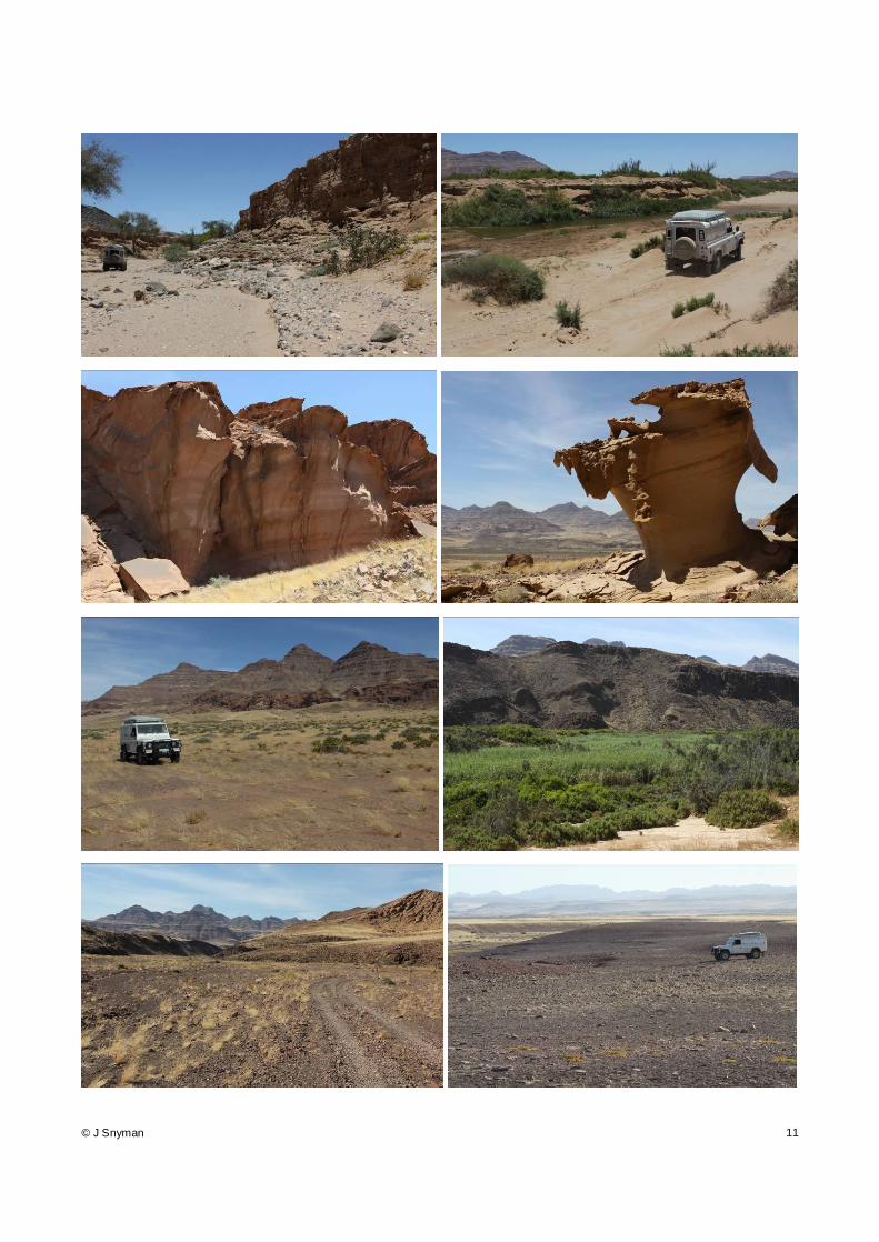
© J Snyman 11

© J Snyman 12
284km for the day (all of it on gravel, sand and rocky roads and tracks) and our travelling time was 11 hours. Saturday 17 December We continued along the Desolation Valley 4wd-trail, crossed the Ubab River at the Ugab Rhino Camp and followed the D2303 to the C34. From here we drove to Swakopmund to collect the Terios before returning to Henties Bay, where we would be spending the next few days fishing with family.

© J Snyman 13
351km for the day (all of it on gravel, sand and rocky roads and tracks) and our travelling time was 5 hours. Sunday 18 December to Thursday 22 December For the next few days we rose early and spent most of the daylight hours with fishing rods in our hands. A westerly wind blew every day and was not conducive to good fishing as it churned up the water. We still had great fun, and managed to land some fish. During this time the Terios served duty as the “granny van”. We now had three 80-year olds with us, and Adri transported them along the coast. As soon as we reached a favourable fishing spot in the morning I would SMS our co-ordinates and once the older folks were ready to travel she would bring them to us. The Terios performed brilliantly on the loose sand and was able to reach any place along the coast. It also received a number of incredulous looks from people with big 4x4’s along the way.

© J Snyman 14
693 km for this period (all of it on salt road and loose sea sand).

© J Snyman 15
Friday 23 December As Adri’s brother, Nico, departed for home in Bloemfontein we prepared to leave on the next part of our trip. We would now be accompanied by Adri’s oldest brother and his family, and an ex-colleague from South Africa, Julian Kruger and family, would be travelling with us for the day. After installing 2-way radios in the 2 new vehicles, we made our way to an old rose quartz mine, a mica mine and the old Strathmore tin mine. The excavation of the tin mine is partially filled with extremely salty water and you can easily float on top of it. From there we made our way to the Messum Crater and from there to the D2342, which we followed to a “stone elephant” that can be seen at a site to the south of the Brandberg. Along the way, the VW Syncro of Julian experienced some mechanical problems. First, the left front brake calliper vibrated loose, but could be re-secured, and then the right-rear shock absorber snapped its shaft. As it was beyond repair we removed it from the vehicle and he drove the vehicle like that back to Walvisbay from there. We followed a track skirting the south and east of the Brandberg to the Ugab River where we would be camping at the White Lady Lodge for the next 3 days.

© J Snyman 16
247km for the day (all of it on gravel, sand and rocky roads and tracks) and our travelling time was 10¼ hours. Saturday 24 December We visited the White Lady rock painting in the morning and I went for a drive during the afternoon to charge the fridge batteries. I travelled upstream in the Ugab River up to the C35 and from there proceeded north on the C35 before returning to camp via the D2319 and some gravel tracks.

© J Snyman 17
183km for the day (all of it on gravel, sand and rocky roads and tracks). Sunday 25 December We spent Christmas day relaxing, and in the afternoon I went for a short drive downstream in the Ugab River to charge the fridge batteries.

© J Snyman 18
63km for the day (all of it in a river bed with thick loose sand and sections of marshland). Monday 26 December It was time to head for home, and we made an early start after saying good bye to the rest of the of the family. We travelled along the D2359 and C35 to Uis, where we refuelled the vehicles before heading south on the D1930 to the Spitzkoppe. We circumnavigated the Spitzkoppe and then headed home via the D3716, B2 and B1. I must admit that it felt strange to be driving on high-speed tarred roads with vehicles all around us.
433km for the day (256km on tar and 177km on gravel) and our travelling time was 7¼ hours. Conclusion This was yet another trip with my favourite travelling companion to a spectacular part of Namibia. The weather on this trip was absolutely amazing. We encountered no rain, daytime temperatures were never higher than mid 30°C and at nights we had to sleep inside our sleeping bags. We encountered very few tourists during the time spent in Damaraland and on most days we did not encounter a single vehicle on the roads and tracks we travelled on – just the way we prefer and like it. We have now covered every single road and track in Damaraland north of the Brandberg, east of the Skeleton Coast, south of Fort Sesfontein and west of Kamanjab and Khorixas and visited every place of interest. We have also covered approximately 90% of the area to the south of the Brandberg and north of the B2. Fortunately the remaining sections can be reached over normal weekends, although it

© J Snyman 19
will involve a lot of driving. There are now a couple of thousand photographs, several thousand km of GPS tracklogs and piles of papers waiting to be sorted out …. With the Landy we drove a total distance of 4841km in the 18 days, of which 664km was on tarred roads and 4179km on gravel, sand, and rocky roads and tracks. With the Terios we drove a total distance of 1550km of which 716km was on tarred roads and 834km was on gravel, sand and rocky roads and tracks. For the period along the coast, when the Terios did a lot of sand driving, its fuel consumption was 11.22km/l. Apart from the single puncture on the Landy, we experienced no problems whatsoever, and are already looking forward to the next trip to this remarkable region.
------------------------