Daily Operations Briefing - Granicus€¦4 Atlantic – Tropical Storm Ernesto As of 8:00 a.m. EDT...
38
1 •Daily Operations Briefing August 8, 2012 As of 8:30 a.m. EDT
Transcript of Daily Operations Briefing - Granicus€¦4 Atlantic – Tropical Storm Ernesto As of 8:00 a.m. EDT...

1
•Daily Operations Briefing August 8, 2012
As of 8:30 a.m. EDT

2
Significant Activity: August 7 – 8 Significant Events:
• None
Tropical Activity:
• Atlantic – Tropical Storm Ernesto; Invest 92L (LOW / 30%); Remnants - Florence (LOW / 0%)
• Eastern Pacific –Tropical Storm Gilma; Invest 93E (MEDIUM / 40%)
• Central Pacific – No tropical cyclones expected through late Thurs night
• Western Pacific – No tropical cyclones affecting U.S. territories
Significant Weather:
• Excessive Heat in the interior of California and in the Desert Southwest
• Showers & thunderstorms – Ohio Valley into Deep South
• Critical Fire Weather Areas & Red Flag Warnings: ID & MT
• Space Weather: No space weather occurred / no space weather predicted
Earthquake Activity: No significant activity
Disaster Declaration Activity: None

3
Atlantic – Tropical Outlook

4
Atlantic – Tropical Storm Ernesto As of 8:00 a.m. EDT
• 90 miles SSE of Campeche, MX
• Moving W at 15 mph
• This motion expected to continue next 24-48 hrs
• On forecast track, center will continue to move over southern
portion of Yucatan Peninsula this morning and emerge over Bay of
Campeche this afternoon
• Forecast to move across southern portion of Bay of Campeche
tonight; approach coast of Mexico within hurricane warning area
on Thurs
• Max sustained winds 60 mph
• Additional weakening expected as it over land this morning
• Re-strengthening forecast after center emerges over Bay of
Campeche; could regain hurricane strength before landfall on
Thurs
• Tropical storm force winds extend 160 miles

5
Atlantic – Area 1 (Invest 92L) As of 8:00 a.m. EDT
• 700 miles WSW of Cape Verde Islands
• Moving W at 10 -15 mph
• Conditions marginally conducive for gradual
development next 24-48 hrs
• MEDIUM chance (30%) of becoming tropical
cyclone next 48 hrs

6
Atlantic – Area 2 (Remnants of Florence) As of 8:00 a.m. EDT
• 460 miles E of northern Leeward Islands
• Moving WNW at about 20 mph
• Not expected to be conducive for redevelopment
• LOW chance (near 0%) of becoming tropical
cyclone again next 48 hrs

7
http://www.nhc.noaa.gov/gtwo_epac.shtml
This product is updated at approximately 5 AM, 11 AM, 5 PM, and 11 PM PDT from May 15
to November 30. Special outlooks may be issued as conditions warrant.
Eastern Pacific – Tropical Outlook

8
Eastern Pacific -Tropical Storm Gilma
As of 5:00 a.m. EDT
• Located 645 miles SW of southern tip of Baja California, MX
• Moving WNW near 13 mph
• This motion with decrease in forward speed expected next
48 hrs
• Maximum sustained winds 70 mph
• Additional strengthening expected; could become a
hurricane today
• Tropical Storm force winds extend 80 miles

9
Eastern Pacific –Area 1(Invest 93E) As of 8:00 a.m. EDT
• 460 miles SSW of Acapulco, MX
• Development is possible; could become tropical
depression next 24-48 hrs
• MEDIUM chance (40%) of becoming tropical
cyclone next 48 hrs

10
Central Pacific – Tropical Outlook

11
http://www.hpc.ncep.noaa.gov/noaa/noaad1.pdf
Daily: 0400 a.m. and 1600
National Weather Forecast

12
http://www.nws.noaa.gov/largemap.php
Active Watches/Warnings

13
Precipitation Forecast 1 – 3 Day
http://www.hpc.ncep.noaa.gov/qpf/d13_fill.gif

14
http://water.weather.gov/ahps/forecasts.php?current_color=flood¤t_type=all&fcst_type=fcst&conus_map=d_map
River Flood Outlook – 7 Day

15
Convective Outlook Days 1 – 3
Day 2 Day 1
Day 3

16
Critical Fire Weather Areas Days 1 – 8
Day 1 Day 2
Day 3-8

17
MAP: http://origin.cpc.ncep.noaa.gov/products/predictions/threats/hazards_d3_7.png
TEXT: http://www.cpc.ncep.noaa.gov/products/predictions/threats/threats_ie.php
Hazard Outlook: August 10 – 14

20
http://www.swpc.noaa.gov/aviation/index.html http://spaceweather.com/
www.spaceweather.com
http://www.swpc.noaa.n/index.html
http://
Space Weather
NOAA Scales Activity Range 1 (minor) to 5 (extreme)
Past 24 Hours Current Next 24 Hours
Space Weather: None None None
• Geomagnetic Storms None None None
• Solar Radiation Storms None None None
• Radio Blackouts None None None
HF Communications Impact Sunspot Activity

21
Significant Earthquake Activity – U.S.
http://earthquake.usgs.gov/earthquakes/recenteqsus/
Southern California
• M4.4 & aftershocks Aug 8 at 2:23 a.m. EDT
• 29 mi ESE Los Angeles
• Depth of 5.1 miles
• No reports of injuries or damage

22
US Wildland Fire Preparedness Levels
As of August 8, 2012
National Preparedness Level: 3 Two (2) or more Geographic Areas are experiencing wildland or prescribed fire activities requiring a major commitment of National
Resources. Additional resources are being ordered and mobilized through NICC. Type 1 and 2 Incident Management Teams are committed
in two (2) or more Geographic Areas and crew commitment nationally is at 50%.
. PL 3
PL 3
PL 3
PL 4
PL 3
PL 1 PL 5
Minimal Extreme
PL 3
PL 1
PL 1
PL 1
PL 2
PL 2

23
Western Wildfire Summary
Fire Name FMAG #
County GACC Name /
# Acres burned
% Contained
Evacuations (Type)
Structures Threatened
Structures Destroyed
Fatalities / Injuries
Oklahoma (6)
Geary Fire 2998-FM-OK
Blaine/Canadian Spur
OK-OKS-42006 978 (-88) 70% No 0 1 0/0
Noble Fire 2999-FM-OK
Cleveland Maguire OK-ECU
7,900 Unk Yes 245 45 0/0
Freedom Fire 5000-FM-OK
Creek McNac
OK-OMA-012044 58,232 60% (+60) No - Lifted 125 50 (+40) 0/0
Luther Fire 5001-FM-OK
Oklahoma Luther 2,621 Unk No 0 2 0/0
Glencoe Fire 5002-FM-OK
Payne Norfolk Road OK-OKS-42009
1,628 (+128) 75% (+75) Yes 240 3 0/0
Drumright Fire 5003-FM-OK
Payne/Creek Cushing
OK-OKS-42008
6,493
(+5,427) 75% (+5) No 0 4 (+3) 0/0

24
Western Wildfire Summary Fire Name (County)
FMAG # Acres burned % Contained Evacuations
(Type) Structures
Threatened Structures Destroyed
Fatalities / Injuries
Montana (2)
Rosebud Complex
(Rosebud County) Not Requested 173,261 30% No 0 4 0/0
Elbow Pass Complex
(Lewis & Clark Co) Not Requested 15, 830 (+164) 25%
Yes
(Mandatory) None 0 0/0
California (1))
Chips Fire
(Plumas County) Not Requested 16,787 (+2,920) 10% (+10)
Yes
(Voluntary) 30 0 0/0
Utah (1)
Pinyon Fire – FINAL
(Utah County) Not Requested 2,959 (+1,359) 40% (+15) No - Lifted 0 0 0/0

25
August 8, 2012:
• National Preparedness Level: 3
• Initial Attack Activity: Moderate (228)
• New Large Fires: 16
• Large Fires Contained: 8
• Uncontained Large Fires: 49
• NIMOs Committed: 1
• Type 1 IMT(s) Committed: 3
• Type 2 IMT(s) Committed: 13
• States Affected: ID, UT, CA, MT, NV, OR,
WA, OK, TX, AR, WY, CO & NM
National Fire Activity

26
Disaster Requests & Declarations
Declaration Requests in Process Requests APPROVED
(since last report)
Requests DENIED
(since last report)
1 Date Requested 0 0
FL- DR Flooding (Appeal) August 6, 2012

29
Deployed Detailed Available Not Available Total
16 1 17 2 36
OFDC Cadre Member Status
Total Available Type 1 Type 2 Type 3 Type 4
20* 3* 11 4 2
As of: 08/03/12
* All Type 1 FCOs are available unless deployed to a Level 1 event
Positions On Board Available Deployed Pending Hire
10 4 3 1 1
Federal Coordinating Officer
Federal Disaster Recovery Coordinator
30
Open Field Offices as of August 8, 2012
31
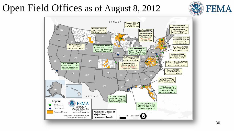
Joint Preliminary Damage Assessments
Number of Counties, Tribes & Cities
Region State Event IA/PA Requested Ongoing Complete Begin/End
V MN Severe Storms/High Winds
July 2 – July 4 PA
5 counties;
2 tribes
5 counties;
2 tribes 0
Began: 7/25
End: TBD
VII NE Wildfires
July 20 – July 30
IA 1 0 0 Begin: 8/13
End: TBD
PA 4 0 0 Begin: 8/13
End: TBD
X WA Severe Storms
July 13 - 20
IA 2 0 2 Began: 8/1
Ended: 8/2
PA 3 (-2) 3 0 Began: 8/7
End: 8/10

32
MCOV Fleet / Deployment Status
Fully Mission Capable 56
Partially Mission Capable 0
Non-Mission Capable 1
Total Not Deployed 54
MCOV FLEET STATUS MCOV DISASTER SUPPORT DEPLOYMENTS
Location Units
Assigned
Available
FMC
Deployed
Committed PMC NMC DR-State OPCON
En
Route Unit Prep
Open
Request Notes:
DC Atlanta 21 17 3 0 1 R4-FL-4068 3 0 0
DC Cumberland 10 10 0 0 0 0 0 0
DC Ft Worth 15 15 0 0 0 0 0 0
DC Moffett 6 6 0 0 0 0 0 0
Holliston, MA 1 1 0 0 0 0 0 0
Denver, CO 2 2 0 0 0 0 0 0
Bothell, WA 2 2 0 0 0 0 0 0
0 0 0
TOTAL 57 53 3 0 1 TOTAL 3 0 0 0
Included in above totals, units en
route for turn-in. 1
Data as of: 08/07/12 @ 1500

34
Active IA Disasters
AL
4052-DR
1971-DR
AZ AR
CA
CO
FL
ID
IL
1991-DR
IN
IA
1998-DR
KS
LA
ME
MA
4028-DR
1994-DR
WI
MN
MO
MT
NE
NV
NM
NY
NC
4019-DR
1969-DR
ND
OH
OR
SC
SD
TN
4060-DR
1979-DR
1974-DR
TX
4029-DR
UT
VA
WA
WY
DE MD
KY
4057-DR
4008-DR
1976-DR
OK
1989-DR
1970-DR
GA
1973-DR
AR
4000-DR
1975-DR
MO
4012-DR
1980-DR
VT
4022-DR
4001-DR
1995-DR ND
1981-DR
MS
MT
1996-DR
NE
4013-DR
SD
1984-DR
PR
4040-DR
4017-DR
NY
4031-DR
4020-DR
NH
4026-DR
PA
4030-DR
4025-DR
VA
4042-DR
NJ
4021-DR
CT
4023-DR
WV
MS
1983-DR
1972-DR
# of DRs Legend
Open Registration Period (60 days from Declaration,
unless extended)
IHP Active – IHP Assistance period remains open
(18 Months from Declaration)
IHP Closing Within 60 Days
1
44
0 Data as of: 08/07/12 @ 1500
IN
4058-DR WV
4059-DR
4061-DR
MI
FL
4068-DR

35
IA Registration Statistics
Cumulative as of August 7, 2012 @ 1500
DR # - State Registrations Approved
Applicants
Total HA
Approved
Total ONA
Approved
Total IHP
Approved
4068 – FL 14,123 5,070 $16,824,916 $2,305,820 $19,130,736
Totals 14,123 5,070 $16,824,916 $2,305,820 $19,130,736
24 hour change +196 +77 +$180,306 +$70,771 +$251,077
NPSC Call Data for August 6, 2012
Total NPSC Calls Answered (Helpline + Registration Intake) 1,566
Average time to answer call 20 seconds

36
IHP Referral Status & Awards
Data includes the 45 IHP Active DRs
# Max Grants = Applicants awarded maximum IHP ($30,200 as of FY2012) Data as of: 08/07/12 @ 1500

37
Housing Inspection Statistics
* Only displaying inspectors for DRs that currently have open registration periods
Data as of August 7, 2012 @ 1600
DR # - State Inspectors Inspections
Assigned
Inspections
Completed
Inspection %
Complete
Turnaround Time
(Days)
4068 – FL 25 11,392 11,121 97.6% 1.8
TOTAL 25 11,392 11,121 97.6% 1.8
24 hour change -1 +162 +155 -0.0% -0.0

38
PA Grant Funding Per Event Type
Only Includes Events Declared Within 12 months of August 7, 2012
Event Type States Declarations
Cumulative
Applicants
Project
Worksheets
Entered Funding Estimate Total Obligated
Percent
Funded
Earthquake - August 2011 2 2 45 219 $37,629,318 $33,112,897 88.0%
Hurricanes/Tropical Storms 17 37 8,685 38,107 $1,882,179,075 $908,308,409 55.5%
Severe Storms/Flooding 15 21 1,578 4,109 $432,826,567 $214,636,188 51.2%
Tornadoes 7 7 272 1,080 $75,142,373 $23,940,223 33.9%
Wildfires 2 2 95 821 $77,436,901 $22,538,586 29.1%
Winter Storms 5 5 719 2,126 $119,871,407 $93,597,449 78.2%
Total for
All Event Types 34 74 11,394 46,462 $2.6 Billion $1.3 Billion 54.9%
Public Assistance Events and Milestones for this Week
• August 6, 2012, William Roche, Director, Public Assistance Division briefed Senate Appropriations Committee staff on next
steps for the PA Courses of Action, the Project Worksheet Process, and Workflow Report and Operations Clean Sweep.
• August 7, 2012, William Roche, Director, Public Assistance Division participated in a conference call with Representative
Hinchey’s staff to discuss the PA pocket guide and PA reimbursements related to tropical storms Irene/Lee
Public Assistance Grants and Activities
39
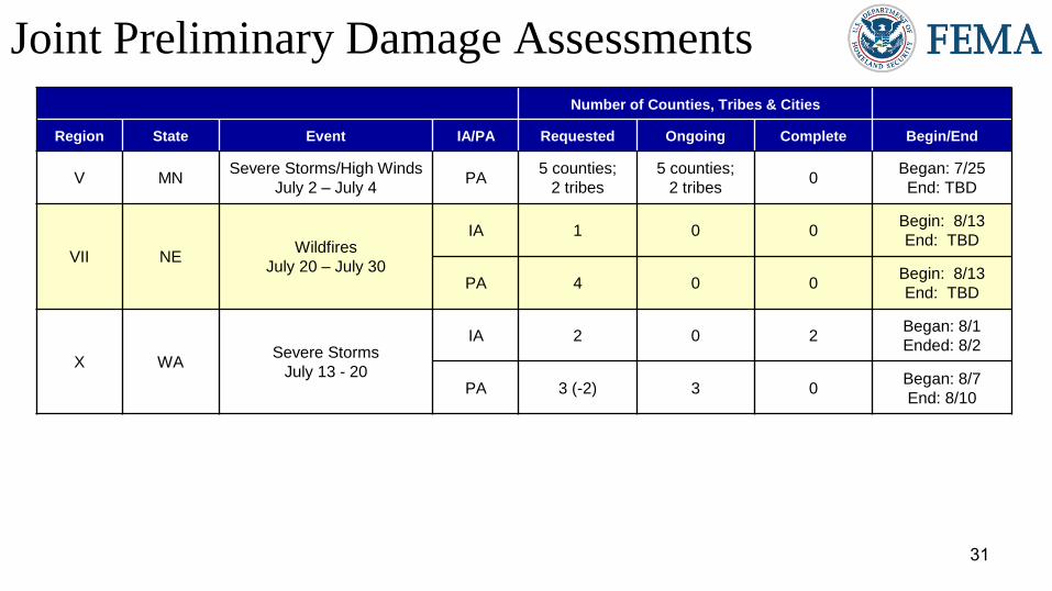
IMAT Status National Teams
Team Status Team Status Team Status
BLUE (East)
WHITE (Central)
RED (West)
Regional Teams
Team Status Team Status Team Status
Region I Region V Region IX-1
Region II Region VI-1 Region IX-2
Region III VA Region VI-2 Region X
Region IV-1 Region VII
Region IV-2 FL Region VIII MT
= Assigned/Deployed
= Out-of-Service
= Available/Mission Capable
= Available/Partially Mission Capable

40
Urban Search & Rescue INCIDENT SUPPORT TEAMS (Red-White-Blue) – Monthly On Call Rotation
JAN FEB MAR APR MAY JUN JUL AUG SEP OCT NOV DEC
WEST CENTRAL EAST
Team Status Team Status Team Status
CA-TF1 Available AZ-TF1 Available FL-TF1 Available
CA-TF2 Available CO-TF1 Available FL-TF2 Available
CA-TF3 Available IN-TF1 Available MA-TF1 Available
CA-TF4 Available MO-TF1 Available MD-TF1 Available
CA-TF5 Available NE-TF1 Available NY-TF1 Available
CA-TF6 Available NM-TF1 Available PA-TF1 Conditionally
Available
CA-TF7 Available NV-TF1 Conditionally
Available VA-TF1 Available
CA-TF8 Available TN-TF1 Conditionally
Available VA-TF2 Available
WA-TF1 Available TX-TF1 Available OH-TF1 Available
UT-TF1 Available
= Assigned/Deployed
= Out-of-Service
= Available/Mission Capable
= Available/Partially Mission Capable

41
Region RRCC Regional Watch Center
I Watch/Steady State Maynard MOC (24/7)
II Watch/Steady State 24/7
III Watch/Steady State 24/7
IV Watch/Steady State 24/7
V Watch/Steady State 24/7
VI Watch/Steady State Denton MOC (24/7)
VII Level III (Monitoring 24/7) 24/7
VIII Level III (7:30-5:00 MDT, M-F) Denver MOC (24/7)
IX Watch/Steady State 24/7
X Level III (7:00-7:00 PDT, M-F) Bothell MOC (24/7)
RRCC / Regional Watch Center Status

42
National Team Status
Team/Status Current Location Remarks
National Watch Center Washington, DC Watch/Steady State
NRCC Washington, DC Not Activated
HLT Miami, FL Activated
DEST Washington, DC Not Activated
Mission Capable Partially Mission Capable Not Mission Capable

44


