Daily Operations Briefing (+70) No 0 0/0 Idaho (1) Minidoka Complex (Sawtooth NF) Not Requested...
41
1 •Daily Operations Briefing August 13, 2012 As of 8:30 a.m. EDT
Transcript of Daily Operations Briefing (+70) No 0 0/0 Idaho (1) Minidoka Complex (Sawtooth NF) Not Requested...

1
•Daily Operations Briefing August 13, 2012
As of 8:30 a.m. EDT

2
Significant Activity: August 10-13 Significant Events: None
Tropical Activity:
• Atlantic – Area 1 (Remnants of TD Seven; Low/10%); Area 2 (Invest 93L; Low/10%)
• Eastern Pacific – Tropical Storm Hector; Area 1 (Invest 95E; Low/20%)
• Central Pacific – No tropical cyclones are expected through Tuesday evening
• Western Pacific – No tropical cyclones affecting U.S. territories
Significant Weather:
• Slight risk of severe thunderstorms lower OH Valley southward across lower MS Valley
• Monsoonal moisture and heat across Southwest
• Critical Fire Weather Areas – None
• Red Flag Warnings: ID; Excessive Heat: CA & AZ
• Space Weather: No space weather occurred/predicted
Earthquake Activity: No significant activity U.S.; M6.4/6.3 Iran’s Eastern Azerbaijan Province
Disaster Declaration Activity:
Amendment No. 3 to FEMA-4067-DR-CO

3
Atlantic – Tropical Outlook

4
Atlantic – Area 1 (Remnants of TD Seven)
As of 8:00 a.m. EDT
• Tropical wave, the Remnants of Tropical
Depression Seven, moving over the Central
Caribbean Sea producing disorganized
showers and thunderstorms from Central
Caribbean northward and northeastward to
Hispaniola
• Environmental conditions are not expected to
be conducive for regeneration
• This system has a low chance (10%) of
becoming tropical cyclone again during the
next 48 hours as it moves westward near 20
mph.

5
Atlantic – Area 2 (Invest 93L) As of 8:00 a.m. EDT
• Shower activity remains limited in association
with a broad area of low pressure located
about 1,200 miles west-northwest of the Cape
Verde Islands.
• Any development of this system is expected to
be slow to occur during the next couple of
days, although environmental conditions could
become more conducive after that time.
• System has a low chance, 10 percent, of
becoming a tropical cyclone during the next 48
hours as it moves west-northwestward at
around 20 mph.

6
http://www.nhc.noaa.gov/gtwo_epac.shtml
This product is updated at approximately 5 AM, 11 AM, 5 PM, and 11 PM PDT from May 15
to November 30. Special outlooks may be issued as conditions warrant.
Eastern Pacific – Tropical Outlook

7
Eastern Pacific – Tropical Storm Hector
As of 5:00 a.m. EDT
• Located about 55 miles south-southwest of Socorro island
or about 345 miles south southwest of southern tip of Baja
California Mexico
• Moving west at 7 mph
• A gradual turn west-northwest with slight decrease in
forward speed is expected during next couple of days
• Max sustained winds have decreased near 40 mph, with
higher gusts
• Little change in strength is forecast next 48 hours
• Tropical storm force winds extend outward up to 115 miles
• No hazards to land

8
Eastern Pacific – Area 1 (Invest 95E) As of 8:00 a.m. EDT
• Weak area of low pressure located near
coast of Mexico about 175 miles southeast
of Acapulco continues to produce showers
and thunderstorms
• Some development is possible during the
next couple of days if system remains
offshore
• System has a low chance (20%) of
becoming a tropical cyclone during next 48
hours as it moves west-northwestward at
10 mph.

9
Central Pacific – Tropical Outlook
10
http://www.hpc.ncep.noaa.gov/noaa/noaad1.pdf
Daily: 0400 a.m. and 1600
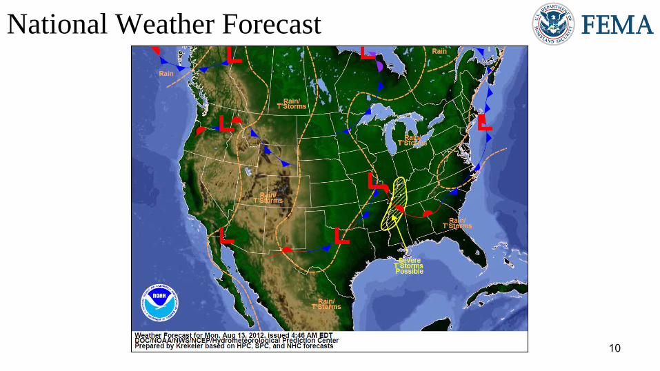
National Weather Forecast

11
http://www.nws.noaa.gov/largemap.php
Active Watches/Warnings

12
Precipitation Forecast 1 – 3 Day
http://www.hpc.ncep.noaa.gov/qpf/d13_fill.gif

13
http://water.weather.gov/ahps/forecasts.php?current_color=flood¤t_type=all&fcst_type=fcst&conus_map=d_map
River Flood Outlook – 7 Day

14
Convective Outlook Days 1 – 3
Day 1 Day 2
Day 3

15
Critical Fire Weather Areas Days 1 – 8
Day 1 Day 2
Day 3-8
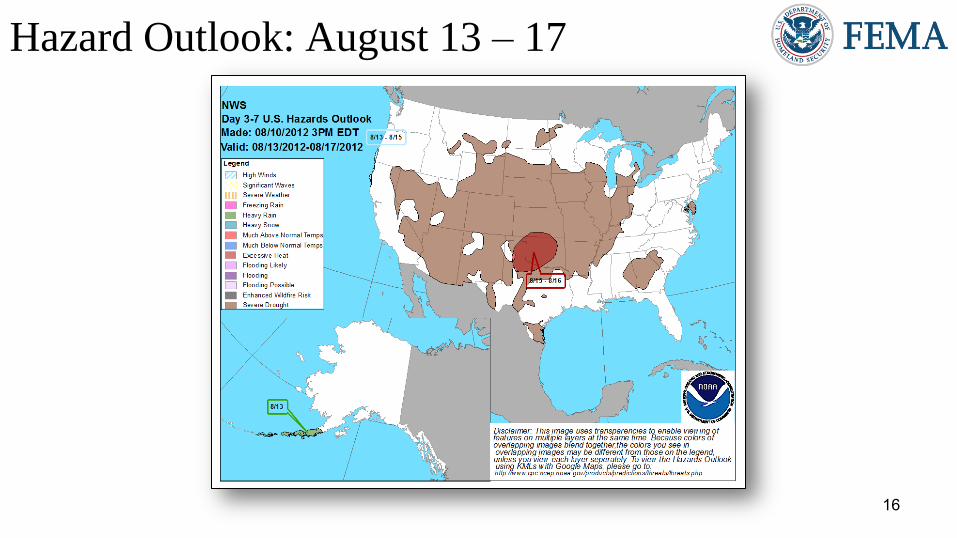
16
MAP: http://origin.cpc.ncep.noaa.gov/products/predictions/threats/hazards_d3_7.png
TEXT: http://www.cpc.ncep.noaa.gov/products/predictions/threats/threats_ie.php
Hazard Outlook: August 13 – 17

19
http://www.swpc.noaa.gov/aviation/index.html http://spaceweather.com/
www.spaceweather.com
http://www.swpc.noaa.n/index.html
http://
Space Weather
NOAA Scales Activity Range 1 (minor) to 5 (extreme)
Past 24 Hours Current Next 24 Hours
Space Weather: None None None
• Geomagnetic Storms None None None
• Solar Radiation Storms None None None
• Radio Blackouts None None None
HF Communications Impact Sunspot Activity

20
Earthquake Activity – U.S.
• No Significant Activity

21
Earthquake Activity – International Northwestern Iran
• M6.4 Earthquake
• August 11, 2012 at 8:23 a.m. EDT
• Followed by M6.3 earthquake 11 minutes
later
• 12 miles WSW of Ahar, Iran
• 37 miles ENE Tabriz, Iran
• Depth: 6.2 miles
• Numerous aftershocks reported
• UN reporting approximately 300 deaths,
approximately 2,000 injured and 17,000
people in need of humanitarian assistance
• Iran Crescent Society has sufficient
resources to meet current needs
• No request for humanitarian assistance
(USGS,OFDA)
Epicenter
Iraq Iran

22
US Wildland Fire Preparedness Levels
As of August 12, 2012
National Preparedness Level: 4 Three or more Geographic Areas are experiencing incidents requiring Type 1 and 2 IMTs. Competition exists between Geographic Areas.
Nationally, 60 percent of Type 1 and 2 IMTs and crews are committed..
PL 3
PL 4
PL 3
PL 4
PL 3
PL 1 PL 5
Minimal Extreme
PL 5
PL 1
PL 2
PL 1
PL 2
PL 3

23
August 13, 2012:
• National Preparedness Level: 4
• Initial Attack Activity: Light (157)
• New Large Fires: 4
• Large Fires Contained: 8
• Uncontained Large Fires: 59
• Area Command Teams committed: 1
• NIMOs committed: 2
• Type 1 IMT(s) committed: 6
• Type 2 IMT(s) Committed: 11
• States Affected: ID, UT, AZ, CA, NV, OR,
MT, OK, TX, WY
National Fire Activity

24
Western Wildfire Summary Fire Name (County)
FMAG # Acres burned % Contained Evacuations
(Type) Structures
Threatened Structures Destroyed
Fatalities / Injuries
Montana (2)
Rosebud Complex
(Rosebud County) Not Requested
▲ 171,444
(-3,380) ▲ 92% (+24) No 0 4 0/0
Elbow Pass Complex
(Lewis & Clark Co) Not Requested 17,454 0% ▲ No None 0 0/0
California (2)
Chips Fire
(Plumas County) Not Requested
▲ 31,720
(+13,031) ▲ 12% (-4)
Yes
(Voluntary)
600 residences/
36 outbuildings/
4 commercial
0 0/0
Wye Fire
(Lake County) Not Requested 5,000 5%
Yes
(Mandatory)
150 residences/
2 businesses 0 0/0
Nevada (2) Bullrun Complex
(Brown’s Gulch Fire)
(Elko County) Not Requested
▲ 58,394
(+55,994) 15% ▲ No 8 2 0/7
Indian Creek Fire
(Lander County) Not Requested
▲ 2,800
(+2,300) ▲ 90% (+90) No ▲ 12 0 0/0
Utah (1) Pinyon Fire
(Utah County) Not Requested ▲ 5,771 (+87)
▲ 100%
(+70) ▲ No ▲ 0 0 0/0
Idaho (1) Minidoka Complex
(Sawtooth NF) Not Requested 92,511 44% No 240 3 0/0
25
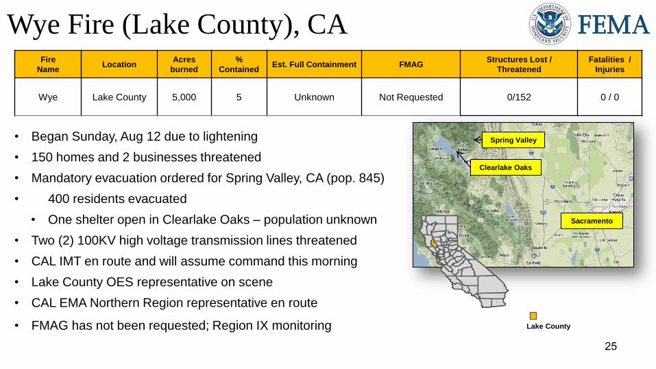
Wye Fire (Lake County), CA Fire
Name Location
Acres
burned
%
Contained Est. Full Containment FMAG
Structures Lost /
Threatened
Fatalities /
Injuries
Wye Lake County 5,000
5
Unknown Not Requested 0/152 0 / 0
• Began Sunday, Aug 12 due to lightening
• 150 homes and 2 businesses threatened
• Mandatory evacuation ordered for Spring Valley, CA (pop. 845)
• 400 residents evacuated
• One shelter open in Clearlake Oaks – population unknown
• Two (2) 100KV high voltage transmission lines threatened
• CAL IMT en route and will assume command this morning
• Lake County OES representative on scene
• CAL EMA Northern Region representative en route
• FMAG has not been requested; Region IX monitoring Lake County
Spring Valley
Sacramento
Clearlake Oaks

26
Disaster Requests & Declarations
Declaration Requests in Process Requests APPROVED
(since last report)
Requests DENIED
(since last report)
1 Date Requested 0 0
FL – DR (Appeal) Severe Storms and Flooding August 6, 2012

27
Declaration
Amendment Number
Effective
Date Amendment Action
Amendment No. 3 to
FEMA-4067-DR-CO August 8, 2012 Appoints Gary R. Stanley, of FEMA, as FCO
Disaster Amendments

28
FMAG Requests and Declarations
Action (since last report) Total FMAG No. and State
Requests DENIED 0
Requests APPROVED 0
Requests Expected Next 24 Hours 0 None as of 1200 8/9/12
As of August 9, 2012 2012 2011*
FMAGs Approved 30 90
FMAGs Denied 13 27
* Cumulative FMAG figures as of this date in 2011

29
Deployed Detailed Available Not Available Total
17 0 17 3 37
OFDC Cadre Member Status
Total Available Type 1 Type 2 Type 3 Type 4
20* 3* 11 4 2
As of: 08/10/12
* All Type 1 FCOs are available unless deployed to a Level 1 event
Positions On Board Available Deployed Pending Hire
10 4 3 1 1
Federal Coordinating Officer
Federal Disaster Recovery Coordinator

30
Open Field Offices as of August 13, 2012

31
Joint Preliminary Damage Assessments Number of Counties
Region State Event IA/PA Requested Ongoing Complete Begin/End
IV TN Severe Storms & flooding
August 5 – 6, 2012 IA 3 3 0
Began: 8/10
End: TBD
V MN Severe Storms/High Winds
July 2 – 4, 2012 PA
5 counties
2 tribes
5 counties
2 tribes 0
Began: 7/25
End: TBD
VI OK Wildfires
July 30, 2012 & continuing IA 4 3 1
Began: 8/9
End: TBD
VII NE Wildfires
July 20 – 30, 2012
IA Withdrawn 0 0 Begin: 8/13
End: 8/16 PA 4 0 0
X WA Severe Storms
July 13 – 20, 2012
IA 2 0 2 Began: 8/1
Ended: 8/4
PA 3 0 3 Began: 8/7
Ended: 8/9

32
MCOV Fleet / Deployment Status
Fully Mission Capable 57
Partially Mission Capable 0
Non-Mission Capable 0
Total Not Deployed 55
MCOV FLEET STATUS MCOV DISASTER SUPPORT DEPLOYMENTS
Location Units
Assigned
Available
FMC
Deployed
Committed PMC NMC DR-State OPCON
En
Route Unit Prep
Open
Request Notes:
DC Atlanta 21 19 2 0 0 R4-FL-4068 2 0 0
DC Cumberland 10 10 0 0 0 0 0 0
DC Ft Worth 15 15 0 0 0 0 0 0
DC Moffett 6 6 0 0 0 0 0 0
Holliston, MA 1 1 0 0 0 0 0 0
Denver, CO 2 2 0 0 0 0 0 0
Bothell, WA 2 2 0 0 0 0 0 0
0 0 0
TOTAL 57 55 2 0 0 TOTAL 2 0 0 0
Included in above totals, units
en route for turn-in.
Data as of: 08/12/12 @ 1500

33
Mission Status
State Total
Deployed
Operational
Mobile DRCs
Pending
DRCs
Awaiting
Assignment
Command and
Control Maintenance
R4-FL-4068 2 0 0 2 0 0
TOTAL 2 0 0 2 0 0
Operational Disaster Recovery Center – Vehicles currently supporting DRC operations Pending DRC – Vehicles scheduled to support DRC operations Awaiting Assignment – Vehicles deployed - awaiting or in-between missions Command and Control – Vehicles supporting a non-Individual Assistance mission Maintenance – Vehicles deployed, but requiring maintenance
MCOV Operational Status
Data as of: 08/12/12 @ 1500
34
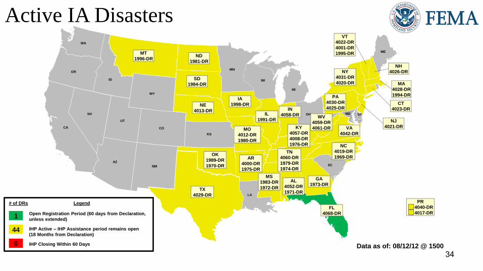
Active IA Disasters
AL
4052-DR
1971-DR
AZ AR
CA
CO
FL
ID
IL
1991-DR
IN
IA
1998-DR
KS
LA
ME
MA
4028-DR
1994-DR
WI
MN
MO
MT
NE
NV
NM
NY
NC
4019-DR
1969-DR
ND
OH
OR
SC
SD
TN
4060-DR
1979-DR
1974-DR
TX
4029-DR
UT
VA
WA
WY
DE MD
KY
4057-DR
4008-DR
1976-DR
OK
1989-DR
1970-DR
GA
1973-DR
AR
4000-DR
1975-DR
MO
4012-DR
1980-DR
VT
4022-DR
4001-DR
1995-DR ND
1981-DR
MS
MT
1996-DR
NE
4013-DR
SD
1984-DR
PR
4040-DR
4017-DR
NY
4031-DR
4020-DR
NH
4026-DR
PA
4030-DR
4025-DR
VA
4042-DR
NJ
4021-DR
CT
4023-DR
WV
MS
1983-DR
1972-DR
# of DRs Legend
Open Registration Period (60 days from Declaration,
unless extended)
IHP Active – IHP Assistance period remains open
(18 Months from Declaration)
IHP Closing Within 60 Days
1
44
0 Data as of: 08/12/12 @ 1500
IN
4058-DR WV
4059-DR
4061-DR
MI
FL
4068-DR

35
IA Registration Statistics
Cumulative as of August 12, 2012 @ 1500
DR # - State Registrations Approved
Applicants
Total HA
Approved
Total ONA
Approved
Total IHP
Approved
4068 – FL 14,615 5,321 $17,473,000 $2,402,510 $19,875,510
Totals 14,615 5,321 $17,473,000 $2,402,510 $19,875,510
72 hour change +208 +108 +$268,845 +$30,448 +$299,293
NPSC Call Data for August 10, 2012
Total NPSC Calls Answered (Helpline + Registration Intake) 1,148
Average time to answer call 11 seconds

36
IHP Referral Status & Awards
Data includes the 45 IHP Active DRs
# Max Grants = Applicants awarded maximum IHP ($30,200 as of FY2012) Data as of: 08/12/12 @ 1500

37
Housing Inspection Statistics
* Only displaying inspectors for DRs that currently have open registration periods
Data as of August 12, 2012 @ 1600
DR # - State Inspectors Inspections
Assigned
Inspections
Completed
Inspection %
Complete
Turnaround Time
(Days)
4068 – FL 18 11,825 11,714 99.1% 1.7
TOTAL 18 11,825 11,714 99.1% 1.7
72 hour change -6 +175 +290 +1.0% -0.0

38
IMAT Status National Teams
Team Status Team Status Team Status
BLUE (East)
WHITE (Central)
RED (West)
Regional Teams
Team Status Team Status Team Status
Region I Region V Region IX-1
Region II Region VI-1 Region IX-2
Region III VA Region VI-2 Region X
Region IV-1 Region VII
Region IV-2 FL Region VIII MT
= Assigned/Deployed
= Out-of-Service
= Available/Mission Capable
= Available/Partially Mission Capable

39
Urban Search & Rescue INCIDENT SUPPORT TEAMS (Red-White-Blue) – Monthly On Call Rotation
JAN FEB MAR APR MAY JUN JUL AUG SEP OCT NOV DEC
WEST CENTRAL EAST
Team Status Team Status Team Status
CA-TF1 Available AZ-TF1 Available FL-TF1 Available
CA-TF2 Available CO-TF1 Available FL-TF2 Available
CA-TF3 Available IN-TF1 Available MA-TF1 Available
CA-TF4 Available MO-TF1 Available MD-TF1 Available
CA-TF5 Available NE-TF1 Available NY-TF1 Available
CA-TF6 Available NM-TF1 Available PA-TF1 Conditionally
Available
CA-TF7 Available NV-TF1 Conditionally
Available VA-TF1 Available
CA-TF8 Available TN-TF1 Conditionally
Available VA-TF2 Available
WA-TF1 Available TX-TF1 Available OH-TF1 Available
UT-TF1 Available
= Assigned/Deployed
= Out-of-Service
= Available/Mission Capable
= Available/Partially Mission Capable

40
Region RRCC Regional Watch Center
I Watch/Steady State Maynard MOC (24/7)
II Watch/Steady State 24/7
III Watch/Steady State 24/7
IV Watch/Steady State 24/7
V Watch/Steady State 24/7
VI Watch/Steady State Denton MOC (24/7)
VII Level III (Monitoring 24/7) 24/7
VIII Level III (7:30 am - 5:00 pm MDT, M-F) Denver MOC (24/7)
IX Watch/Steady State 24/7
X Watch/Steady State Bothell MOC (24/7)
RRCC / Regional Watch Center Status

41
National Team Status
Team/Status Current Location Remarks
National Watch Center Washington, DC Watch/Steady State
NRCC Washington, DC Not Activated
HLT Miami, FL Activated
DEST Washington, DC Not Activated
Mission Capable Partially Mission Capable Not Mission Capable

43
Regional Comparison – as of August 13, 2012

44