D5.2 Process Map for Autonomous Navigation (download)
59
Grant Agreement number: 314286 Project acronym: MUNIN Project title: Maritime Unmanned Navigation through Intelligence in Networks Funding Scheme: SST.2012.5.2‐5: E‐guided vessels: the 'autonomous' ship D5.2: Process map for autonomous navigation Due date of deliverable: 2013‐07‐31 Actual submission date: Start date of project: 2012‐09‐01 Lead partner for deliverable: Fraunhofer CML Project Duration: 36 months Distribution date: 2013‐09‐27 Document revision: 1.0 Project co‐funded by the European Commission within the Seventh Framework Programme (2007‐2013) Dissemination Level PU Public Public PP Restricted to other programme participants (including the Commission Services) RE Restricted to a group specified by the consortium (including the Commission Services) CO Confidential, only for members of the consortium (including the Commission Services)
Transcript of D5.2 Process Map for Autonomous Navigation (download)

GrantAgreementnumber:314286Projectacronym:MUNINProjecttitle:MaritimeUnmannedNavigationthroughIntelligenceinNetworksFundingScheme:SST.2012.5.2‐5:E‐guidedvessels:the'autonomous'ship
D5.2:Processmapforautonomousnavigation
Duedateofdeliverable:2013‐07‐31Actualsubmissiondate:
Startdateofproject:2012‐09‐01Leadpartnerfordeliverable:FraunhoferCML
ProjectDuration:36months
Distributiondate:2013‐09‐27 Documentrevision:1.0
Projectco‐fundedbytheEuropeanCommissionwithintheSeventhFrameworkProgramme(2007‐2013)
DisseminationLevelPU Public PublicPP Restrictedtootherprogrammeparticipants(includingtheCommissionServices)RE Restrictedtoagroupspecifiedbytheconsortium(includingtheCommissionServices)CO Confidential,onlyformembersoftheconsortium(includingtheCommissionServices)

MUNIN – FP7 GA‐No 314286
D5.2 ‐ Print date: 14/01/07
Status: final 2/59 Dissemination level: PU
DocumentsummaryinformationDeliverable D5.2:Processmapforautonomousnavigation Classification PU(public)Initials Author Organization RoleWB WilkoBruhn CML EditorHCB Hans‐ChristophBurmeister CML EditorLW LauraWalther CML ContributorJM JonasMoræus APT ContributorML MattLong APT ContributorMS MichèleSchaub HSW ContributorEF EnricoFentzahn Msoft ContributorRev. Who Date Comment0.1 WB 2013‐08‐01 Firstdraft0.2 ØJR 2013‐08‐12 Partnerreview0.3 AV 2013‐08‐13 Partnerreview0.4 BS 2013‐08‐13 Partnerreview0.5 WB 2013‐08‐30 Seconddraftaftercomments1.0 HCB 2013‐08‐27 FormatingInternalreviewneeded: [X ]yes []noInitials Reviewer Approved NotapprovedFS FariborzSafari X AV AriVésteinsson X
DisclaimerThecontentofthepublicationhereinisthesoleresponsibilityofthepublishersanditdoesnotnecessarilyrepresenttheviewsexpressedbytheEuropeanCommissionoritsservices.
Whiletheinformationcontainedinthedocumentsisbelievedtobeaccurate,theauthors(s)oranyotherparticipantintheMUNINconsortiummakenowarrantyofanykindwithregardtothismaterialincluding,butnotlimitedtotheimpliedwarrantiesofmerchantabilityandfitnessforaparticularpurpose.
Neither the MUNIN Consortium nor any of its members, their officers, employees or agents shall beresponsible or liable in negligence or otherwise howsoever in respect of any inaccuracy or omissionherein.
Without derogating from the generality of the foregoing neither theMUNIN Consortium nor any of itsmembers,theirofficers,employeesoragentsshallbeliableforanydirectorindirectorconsequentiallossordamagecausedbyorarisingfromanyinformationadviceorinaccuracyoromissionherein.
MUNIN – FP7 GA‐No 314286
D5.2 ‐ Print date: 14/01/07
Status: final 3/59 Dissemination level: PU
Executivesummary
The shift frommanned to unmanned and autonomous navigation raises fundamentalquestions on how operational processes should be structured in order to ensure thesafetyoffutureshipping.Comingfromtoday’sconventionalshipping,existingactivitiesand processes used for navigation have been recorded, mapped and adopted to therequirementsoftheMUNINconcept.Followinganintroduction,theframeworkfortheAutonomousBridgeSystemisoutlinedtoconnect it totheMUNINconcept’sarchitectureandtoshowthisdeliverable’sscopeand its boundaries.Within chapter three, presentmanned ship operation is analyzed,taking into account technology, information requirements, legal framework, processesandresponsibilities.The fourthchapterderivesactivities fromcurrentshipoperation,identifiesandclassifies themtobeable todrawaconclusion for theprocessredesignwithin this deliverable. Subsequently, a process map for autonomous navigation isestablished in chapter five and corresponding requirements for the Advanced SensorSystemandtheAutonomousShipControllerarelistedinthefollowingchapter.Withinchapter seven, the interfaces to the Shore Control Center and the Engine AutomationSystem are explained. Finally, the research needs for the further development of theMUNIN concept for autonomous navigation are described in the eighth chapter. Also,possiblesolutionstomeetthepreviouslydefinedrequirementsarereviewedtherein.

MUNIN – FP7 GA‐No 314286
D5.2 ‐ Print date: 14/01/07
Status: final 4/59 Dissemination level: PU
Listofabbreviations
ABS AutonomousBridgeSystem
ACCSEAS AccessibilityforShipping,EfficiencyAdvantagesandSustainability
AEMC AutonomousEngineMonitoringandControl
AIS AutomaticIdentificationSystem
ASC AutonomousShipController
ASS AdvancedSensorSystem
BAS BridgeAutomationSystem
CCTV Closed‐CircuitTelevision
CDEM Construction,Design,EquipmentandManning
Chayka Seagull(Russianterrestrialradionavigationsystem)
COLREG InternationalRegulationsforPreventingCollisionsatSea
CoG CourseoverGround
CPA ClosestPointofApproach
DGPS DifferentialGlobalPositioningSystem
DSC DigitalSelectiveCalling
EAS EngineAutomationSystem
ECDIS ElectronicChartDisplayandInformationSystem
EEZ ExclusiveEconomicZone
eLORAN EnhancedLongRangeNavigation
ENC ElectronicNavigationalChart
EOT EngineOrderTelegraph
EPIRB EmergencyPosition‐IndicatingRadioBeacon
ETA EstimatedTimeofArrival
FtS Fail‐to‐Safe
GHz Gigahertz
GLONASS GlobalnayaNavigatsionnayaSputnikovayaSistema
GNSS GlobalNavigationSatelliteSystem
MUNIN – FP7 GA‐No 314286
D5.2 ‐ Print date: 14/01/07
Status: final 5/59 Dissemination level: PU
GMDSS GlobalMaritimeDistressandSafetySystem
GPS GlobalPositioningSystem
HF HighFrequency
IAMSAR InternationalAeronauticalandMaritimeSearchandRescueManual
ICS InternationalChamberofShipping
INS IntegratedNavigationSystem
IMO InternationalMaritimeOrganization
LAN LocalAreaNetwork
LDC LondonConventiononthePreventionofMarinePollutionbyDumpingofWastesandotherMatter
LLC InternationalConventiononLoadLines
LORAN LongRangeNavigation
MARPOL InternationalConventionforthePreventionofPollutionfromShips
MF MediumFrequency
MLC MaritimeLabourConventionoftheInternationalLabourOrganization
MMSI MaritimeMobileServiceIdentity
MONALISA MotorwaysandElectronicNavigationbyIntelligenceatSea
MUNIN MaritimeUnmannedNavigationthroughIntelligenceinNetworks
NAVTEX NavigationalTelex
OOW OfficerofWatch
PiLoNav Precise and Integer Localization andNavigation in Rail and InlandwaterTraffic
PiW PersoninWater
PoC PortofCall
RoT RateofTurn
RPC RemoteProcedureCall
RpM RevolutionsperMinute
SAR SearchandRescue
SART SearchandRescueTransponder
SCC ShoreControlCenter

MUNIN – FP7 GA‐No 314286
D5.2 ‐ Print date: 14/01/07
Status: final 6/59 Dissemination level: PU
SDME SpeedandDistanceMeasuringEquipment
SoG SpeedoverGround
SOLAS InternationalConventionontheSafetyofLifeatSea
STCW International Convention on Standards of Training, Certification andWatchkeepingforSeafarers
TCPA TimetoClosestPointofApproach
THD TransmittingHeadingDevice
TSS TrafficSeparationScheme
UAS UnmannedAutonomousShip
UKC Under‐KeelClearance
UNCLOS UnitedNationsConventionontheLawoftheSea
UTC CoordinatedUniversalTime
VHF VeryHighFrequency
VSAT VerySmallApertureTerminal
VTS VesselTrafficServices
XTE CrossTrackError

MUNIN – FP7 GA‐No 314286
D5.2 ‐ Print date: 14/01/07
Status: final 7/59 Dissemination level: PU
Tableofcontents
Executivesummary...............................................................................................................................3
Listofabbreviations.............................................................................................................................4
1. Introduction....................................................................................................................................9
2. FrameworkfortheAutonomousBridgeSystem..............................................................10
3. As‐Is‐Analysisofpresentmannedshipoperation...........................................................10 3.1 State‐of‐the‐arttechnologyanalysis...........................................................................................10 3.2 Informationrequirements...............................................................................................................15 3.3 Legalframework..................................................................................................................................19 3.4 Processesandresponsibilities.......................................................................................................21
4. Identificationandclassificationofactivities.....................................................................23 4.1 Activitiesrelatedtovoyageplanning.........................................................................................23 4.2 Activitiesrelatedtolookout...........................................................................................................23 4.3 Activitiesrelatedtobridgewatch................................................................................................24 4.4 Activitiesrelatedtomaneuvering................................................................................................24 4.5 Activitiesrelatedtocommunication...........................................................................................25 4.6 Activitiesrelatedtoadministration............................................................................................25 4.7 Activitiesrelatedtoemergencies.................................................................................................25
5. Processmapforunmanneddeepseashipoperation....................................................26 5.1 Determineposition,heading,speedanddepth......................................................................29 5.2 Keeplogbook........................................................................................................................................29 5.3 Conductlookout(weather).............................................................................................................30 5.4 Conductweatherrouting.................................................................................................................31 5.5 Provideenginedata............................................................................................................................32 5.6 Determineshipstatus........................................................................................................................32 5.7 Determineshipdynamics................................................................................................................33 5.8 Controlautonomousship.................................................................................................................34 5.9 Followtrack(autopilot)...................................................................................................................34 5.10 Controlbuoyancyandstability......................................................................................................35 5.11 Avoidcollision.......................................................................................................................................36 5.12 Planvoyage............................................................................................................................................37 5.13 Conductlookout(traffic)..................................................................................................................38 5.14 ReceiveNAVTEXandSafetyNETdata........................................................................................39 5.15 Managealarmsandemergencies.................................................................................................39 5.16 ReceiveAISdata...................................................................................................................................40
6. SpecificationrequirementsfortheAutonomousBridgeSystem...............................41 6.1 Determineposition,heading,speedanddepth......................................................................41

MUNIN – FP7 GA‐No 314286
D5.2 ‐ Print date: 14/01/07
Status: final 8/59 Dissemination level: PU
6.2 Conductlookout(weather).............................................................................................................42 6.3 Conductweatherrouting.................................................................................................................43 6.4 Determineshipstatus........................................................................................................................44 6.5 Determineshipdynamics................................................................................................................45 6.6 Controlbuoyancyandstability......................................................................................................46 6.7 Avoidcollision.......................................................................................................................................47 6.8 Conductlookout(traffic)..................................................................................................................49 6.9 Managealarmsandemergencies.................................................................................................51
7. InterfacesoftheAutonomousBridgeSystem...................................................................53 7.1 InterfaceswithSCC.............................................................................................................................53 7.2 InterfaceswithEAS.............................................................................................................................54
8. Identificationofresearchneeds............................................................................................54

MUNIN – FP7 GA‐No 314286
D5.2 ‐ Print date: 14/01/07
Status: final 9/59 Dissemination level: PU
1. Introduction
Basedontheactivitiesandrequirementsfornavigationwhichhavebeenpresentedanddeveloped further at the MUNIN consortium meeting in Reykjavik in March 2013 aprocessmaphasbeenestablished.Inaccordancewiththeproject’svisiontocontributeto the enhancement of safety in conventional shipping, the starting point for thisdeliverable’sresults istobefoundintoday’sconventionalshipoperations.Bykeepingclosetoexistingprocessesatransferofindividualelementsoftheproject’santicipatedoutcomeintomannedshippingshallbeeasedandnecessarylegaladjustmentsreducedtoaminimum.Besidestheelaborationoftheprocessmapitself,afocushasbeenputtofititwellintothearchitectureconceptforunmannedandautonomousshippingandtoensuresmoothinterface connections between the Autonomous Bridge System ABS, the EngineAutomationSystemEASandtheShoreControlCenterSCC.BelowpictureillustratesinasimplifiedwaytheinterrelationshipofallcomponentsofanunmannedandautonomousshipaccordingtotheconceptoftheMUNINproject.
This document represents the first integral layout for bridge processes fromrestructuring the task of ship navigation for unmanned and autonomous deep seavoyages.InanupcomingdeliverablethistopicwillbefurtherinvestigatedtoconstituteD5.4Autonomousdeepseanavigationsystemconcept.

MUNIN – FP7 GA‐No 314286
D5.2 ‐ Print date: 14/01/07
Status: final 10/59 Dissemination level: PU
2. FrameworkfortheAutonomousBridgeSystem
TheABSconstitutesthecentralcomponentwithintheconceptfortheautonomousshipwhichisresponsibleforallnavigation‐relatedmatters.Toenabletheoperationofacompletelyunmannedandtrulyautonomousbridge,stronganddirectconnectionstotheothercomponentsonboardandashorearenecessary.Eachone of these components form part in replacing an onboard human informationprovider and decisionmaker. In conventional shipping, evenwith themost advancedandcomprehensiveequipment,theOOWstillactsasthesoletruesystemintegrator.TheMUNINconceptnowaimstoshiftthisfunctiontoanautonomousshipcontrollerwhichisbeingsupervisedandsupportedbyamannedshoresidecontrolstation.Thefirstandmajorrequirement in thedevelopment towardsautonomy is the improvementofdataavailability and quality. An Advanced Sensor Systemwill be able to produce resilientinformationaboutthecurrentsituationoftheship.TheEngineAutomationSystemEASwillensuresmoothoperationof technical installationsrelatedtopropulsionplantandsteering gear. Existing bridge functionalities will be adopted to fit into a BridgeAutomationSystemBASasanABSsupportcomponent.Thesementionedmodulesarealldirectlyinterlinkedwitheachother,theAutonomousShipControllerASCandtheSCCbysatelliteconnection.ThecontentofthisdeliverableislimitedtodeepseanavigationonlyanddoesconsiderneitheroperationssuchaspilotageorberthingnornavigationwithinaTSSoranarrowchannel. Interfaces of the ABS to the SCC and the EAS are described in autonomousoperation mode only, while the functionalities of those components with no directrelationtonavigationarenotcovered.InformationfromD4.3EvaluationofshiptoshorecommunicationlinksandD4.4Initialinterfacedescriptionarerespectedtofit theremappedprocesseswell intotheMUNINarchitecturealsowithregardtolimitationsforcommunication.Furthermore,referenceismadetoD5.1Legalandliabilityanalysisforautomatednavigationalsystemsinorderto reduce the necessary adjustments in internationalmaritime legislation. To includefall‐back solutions within the process redesign, D7.1 Error and human interventionreportinthecontextofautonomousshipshasalsobeenaccountedforwithinthispaper.Beyond that, it is also intended to give guidance for the transition from this generalconcept of autonomous navigation to the development of D5.3 Sensor systems forautomateddetection.
3. As‐Is‐Analysisofpresentmannedshipoperation
3.1 State‐of‐the‐arttechnologyanalysis
Positionmeasurement

MUNIN – FP7 GA‐No 314286
D5.2 ‐ Print date: 14/01/07
Status: final 11/59 Dissemination level: PU
Sincetheintroductionofsatellitenavigationforciviluse,GNSShaschangedthefaceofnavigation. Reliable position data is ever since available on every spot of the planet’ssurface. GPS receiverswhich are in use on present daymerchant shipsworkwith anaccuracyof10to20metersontheopenseaandDGPSwiththecorrectionoflandbasedreferencestationswithanaccuracyof3to10meters.AdvancedGNSSreceiversareableto process signals from both GPS and GLONASS. As of now these are the only twosatellite navigation systems that have been approved by IMO and thus neither theChinese Compass‐system nor the European Galileo‐system will be examined furtherwithinthispaper.TheuseofGNSSdevicesisthemostpreferredmethodofproducingvalidpositiondata.BothGPSandGLONASSofferworldwidecoverageatasufficientpositiondataquality.TobepreparedforamalfunctionoftheseGNSSdevices,othermeanstodeterminetheship’spositionhavetobeavailable.RadionavigationsystemssuchasLORANorChaykacouldrepresentavalidalternativetoGNSS,ifitwouldn’tbefortheirlimitedregionalavailability.Firstly,therangefromtheshore side stations is limited to several hundrednauticalmiles extending from shore.Secondly, the future of radio navigation appears to be uncertain due to the fact thatoriginallysomecountrieshaveannouncedtodiscontinuetheirservicewhileothersareenhancing thesystem further towardseLORAN.This limits theusabilityof thesystemconsiderablyandisanotherreasonwhycurrentlyonlyalimitednumberofshipscarryradionavigationdevicesatall.This isaveryunfavorable factduetothesystem’shighreliability,accuracyandimmunityagainstmanykindsofinterferences.Anothermeansofpositioningcommonlyusedonmannedships iscelestialnavigation.Whetheranautomatedsextantwillbeautilizablemethod forpositioningneeds tobefurther examined within the project. In coastal areas, terrestrial navigation is also asuitable method for positioning. As another tool of choice, the technique of deadreckoning can always be employed. This method of navigation uses the last knownpositionand thespeedoverelapsed timeandcourse tocalculate thecurrentposition.Thismethodofnavigationhasbeenusedforalongtimeandisinusetodaywithinmanyinertialnavigationsystemsandproducessurprisinglyaccuratepositiondata.HeadingmeasurementEvery ship is equippedwith a gyro compass and amagnetic compass to indicate theship’sheading.Thegyrocompassisusedastheprinciplecompassonboard,mainlyforitshighaccuracyandlowlikelinessofbreakdown.Themagneticcompassmayappeartobearelicfromanotherage.Yetactually,itisstillinusebecauseofitsrobustnessanditscomplete independence fromelectricpowersupply.Bothof thesecompass typeshavethe disadvantage of relatively low course accuracy during heavy sea or intensemaneuveringsothatthedisplayedheadingcan’tbepreciselyrelieduponfornavigationunder these specific circumstances. A more advanced alternative can be satellitecompasses, which basically consist of a set of integrated GNSS‐sensors. Beyond only

MUNIN – FP7 GA‐No 314286
D5.2 ‐ Print date: 14/01/07
Status: final 12/59 Dissemination level: PU
providingtheship’sheadingthesedevicesarealsocapableofindicatingtheship’sRoTas well as pitch, roll, heave and position information, of course. Another option,producingthemostaccurateheadinginformation,isthefiber‐opticcompass.Asamereelectronic rotation rate sensor it is almost free of wear and maintenance during itsservice life. Modern but only rarely used multi‐compass systems consist of acombinationoftheabovementionedsystemsandcombinetheiradvantagestoproduceamoreaccuratereadingfortheship’sheading.DepthmeasurementTheechosoundingdeviceswhichareinuseincommercialshippingmeasuretheverticaldepth below the ship’s keel bymeans of acoustic soundwaves. The current and pastdepthcontourisdisplayedwithapossibleerrorinaccuracyofapproximately2.5%ofthemeasureddepthwhichrangesupto1500meters.Athresholdcanbesetsothatadepthalarmwill sound incasethepre‐selecteddepthcontour isunderrun.Foraverylimitednumberofcoastalseaareastherearealsodraft informationsystemsavailable,which calculate the ship’s under‐keel clearance from the ship’s draft, detailedbathymetricchartsandrealtimewaterlevelsfromshoregaugestations.Similarsystemscanalsobeusedonanumberofcoastalshippingroutestobenefitfromtidalstreamsinordertosavebunker.SpeedanddistancemeasurementThe ship’s voyage speed canbedeterminedby fourdifferentmeasurementdevices.Ahydromechanicspeedlogmeasurestheahead‐speedthroughwaterbythepressureatan impact tubewith themajor disadvantage that this tube gets easily clogged. A lesserror‐pronemethodforspeedmeasurementthroughwaterisbyanelectromagneticlog,wherevoltageisbeinginducedbetweenaprobeandapairofelectrodestodeterminethe speed through water. The most commonly used device is a Doppler‐log, whichmeasuresthespeedovergroundbymeansofsonarwavesuptoawaterdepthof600meters. At higher depths, the speed throughwater can be determined. Bothmethodsoperate regularly with an error in accuracy of approximately 0.5% to 1.0% of themeasured speedwhile significantly larger inaccuracies can be experienced. ThemoreadvancedDoppler‐logsareabletodisplayahead‐,asternandtransversespeed,RoTandalsowater depth. In addition, the speed over ground can easily be calculated by anyautomaticpositioningappliance.Thedistancessailedcaneasilybecalculatedfromthisknownspeedovertime.TrackpilotOntoday’sshipsthesteeringcontrolcaneasilybeautomatedtoagreatextent.Moderntrackcontrolautopilotsareabletopreciselyfollowthecourseovergroundlaidoutbythevoyageplanwithdeviationsofonlyabouthalfof theship’sbreadth.Furthermore,throughself‐tuningadoptionmanysteeringparametersaredeterminedby thesystemitself. The ship’s loading characteristics and the indirect steering effect of the ship’spropeller are accounted for and the effects of wind, sea state and current are
MUNIN – FP7 GA‐No 314286
D5.2 ‐ Print date: 14/01/07
Status: final 13/59 Dissemination level: PU
compensated.Throughtherudderactuatingvaluesthepermissiblerateofturnandtheradiusofturncanbeset.Also,steeringcriteriacanbechosenbetweenprecisesteeringtominimizeXTEandeco‐steeringtominimizefuelconsumption.Someapplicationsalsoofferanextensivefeaturetoadjustthevoyagespeedaccordingtoadesignatedarrivaltimeatadefinedwaypoint.AISThe use of AIS‐transceivers has had a major impact on the safety of shipping.Information about asmany as 500 targetswithin a range of up to 30nmhas becomeeasilyavailable.Thedevicetransmitsandreceivesdataaboutaship’sname,type,size,status, position,heading, speed, cargo,nextportof call aswell as its IMO‐andMMSI‐numberviaVHFradio.Thedata iseither fixed input,needstobeenteredmanuallyororiginates directly from the ship’s sensors. Due to the fact that the displayed data’saccuracyandreliabilitycan’tbeassessed,AISisaccreditedasanaidtonavigationonly.Radar/ARPAThemost provenmethod to detect andmonitor objects is by the use of radarwhichworksthroughtheemissionandreceptionofelectromagneticimpulses.MerchantshipsarealwaysequippedwithoneshortpulseX‐bandantennaforhighresolutionandonelong pulse S‐band antenna for high range. Both of them operate with an error inaccuracyofnomorethan1.0%oftheircurrentworkingrangeor30metersatthemost.The radar picture is than being processed by the ARPA function to continuously andautomatically plot the acquired targets to determine distances and bearings towardsthat object. Also, the object’s speed, course and position can be calculated, if thecorresponding own ship data is available. Radar/ARPA devices are subject to certainerrors through either false echoes caused by multiple echo reflection, by extraneousradarwavesorbyfalseinputdatafromownshipsensors.CertainX‐bandradar‐basedwaveandsurfacemeasurementtechnologycanbeusedforoceansurfacemonitoringaswell.ECDIS/INSThevastmajorityofmerchantshipswhichtraveltheoceansnowadaysareobligedtobefittedwithanECDIS.Theperformancecapabilitiesvarytosomedegree,dependingonthemanufacturerandtheageoftheapplication.Butallofthemmustgenerallybeabletofullyreplacepaperchartsonaship’sbridgeasatwo‐unit‐installation.Thenavigationinformation system displays digital navigable sea charts and offers the possibility forintegrationofnauticalpublications.Furthermore, sensordata fromAIS, echosounder,GNSS,NAVTEX,radar/ARPAcanalsobeinterfacedwiththesystemanddisplayedonthescreen. Each inputdata valueoriginates fromone singlepredefined sourceand is notcounterchecked against data from redundant sensors for probability. That’s why theOOW still remains the only true system integrator on the ship’s bridge. Beyond theprovisionofinformation,anECDISallowsforallfeaturesofconventionalchartworkand

MUNIN – FP7 GA‐No 314286
D5.2 ‐ Print date: 14/01/07
Status: final 14/59 Dissemination level: PU
alsoassistsinvoyageplanningandpassagemonitoring.Additionally,thesystemoffersalogbookfunctionandanavigationalalarmmanagementsystem.ThemostevolvedholisticapproachestofurtherdevelopanECDIStowardsMUNIN’saimof an autonomous bridge system are integrated navigation systems. These IntegratedNavigationSystemsINSpromotesafetyofnavigationbyenablingacentralizedaccesstoall available navigational information and by monitoring the quality of data andprocesses.Throughreferencepointsforthepositionsofantennaeandsensorswithinaconsistent common reference system reliable calculation of standardized data for e.g.time,position,headingandspeedcanbecarriedout. Incasethereareseveralsourcesfor the same value these are being processed to determine one resilient value to bedistributedthroughoutthesystem.Thiskindofdatafusingimprovesthequalityoftheinformationproducedandtheoutputofthefollowingprocessesbeingused.Inaddition,INS’ are able to combine various tasks, functions, sensors and systems on the ship’sbridgeandenablefulldataaccesstotheuserviaasingleinterface.Acertaindegreeofredundancy within the sensors ensures that all necessary data can be acquired by anumberofindependentlyworkingsensors.VDRA Voyage Data Recorder gathers and stores all available information about the ownship’sstatus,positionandmovementaswellasallsoundsfromwithinthewheelhouseandfromvoiceradio.Therecordeddataofatleastthepasttwelvehoursiskeptwithinaretrievableunittobeusedforfutureanalysisincaseofanincidentandmustthereforebe secured against any attempts of tampering. The VDR must be equipped with anemergencypower supply to be able to operate even in case of blackout for at least 2hours.TelecommunicationAllmeansofmaritimetelecommunicationarepartoftheGlobalMaritimeDistressandSafety Systemwhich is basedonboth radio and satellite communicationdevices.DSCradiotelephony operates on VHF, MF and HF and is used for the transmission andreception of voice radio, distress alert and distress relaymessages. Also,mobile VHFdevices are in use for voice radio communication, while radiotelex transceivers forwritten communication and NAVTEX receivers for navigational and meteorologicalwarningsoperateonMFandHF. Satellite communicationvia Inmarsatdevices allowsfor the reception of NAVTEX‐messages outside of radio range and of SafetyNET‐messages.Additionally,voicetelephony,transmissionandreceptionoftextmessagesviatelefax,telexande‐mailareprovided.ManyoftheseGMDSSelementscanalsobeusedfordistressalertingwhileEPIRBandSARTareinstalledonboardforthatsolepurposeonly./1/2/

MUNIN – FP7 GA‐No 314286
D5.2 ‐ Print date: 14/01/07
Status: final 15/59 Dissemination level: PU
3.2 Informationrequirements
TheoperationalrequirementsforthedifferenttechnicaldeviceslistedbelowaresetbytheIMOasthecompetentinternationalbody.SatellitenavigationTheuseofaGNSSreceiverismandatoryonboardofallshipsirrespectiveoftheirsize./3/AGlobalNavigationSatelliteSystemisasatellitesystemthatallowstodetermineaposition in latitudeand longitudeaswell asof velocityand timeworldwide.Thedataquality in satellite navigation can be further enhanced by the use of land‐baseddifferentialcorrectionsignalsorbytheintegrationofothermeansofpositioning.Suchcombinedreceivershave tohavea staticandadynamicaccuracywithin35meters innon‐differentialmodeand10metersindifferentialmodewhiletheminimumresolutionofpositioninlatitudeandlongitudeis0.001minutes./4/RadionavigationLORAN and Chayka are the only two long‐range radio navigation systems currentlyoperatedand in those sea areas covered they represent a valid alternative to satellitenavigation.Theirrangesmayvarydependingondifferentfactorsbutaresaidtoextentto approximately1000nm from the transmitter station at themost. The receivers foreitheroneorforbothsystemsshouldproducevalidpositiondatawithin7.5minutesofbeingswitchedonwithapositionaccuracyof20to90meters.Theacquisitionofsignals,cycleselectionandtrackingmustbefullyautomaticandproducevalidpositiondataatshipspeedsofupto35kn./5/Radionavigationsignalavailabilityshouldexceed99.8%inhigh‐traffic areasand99.5% in low traffic areaswhilea99.85%service reliabilityshouldnotbeunderrun. Incoastalareaswithdense traffic theaccuracy forpositionalinformation should bewithin 10meterswith a 95%probability at 10second updaterates. In low‐traffic open sea areas the error for positional information should notexceed100meterswitha95%probabilityat10secondupdaterates./6/Anadvantageof radio navigation compared to satellite navigation is that the signals don’t getdistractedaseasilyandpositioningismorepreciseine.g.portareas.HeadingmeasurementEachshipfrom500grosstonnageupwardsmustbefittedwithtwomeanstodetermineanddisplaytheship’sheadingatthemainsteeringposition.Oneofthesehastobenon‐magneticwhile theotheronehastobe independentofanypowersupply.Usually thisrequirementismetwiththeinstallationofonegyroandonemagneticcompass./7/Agyrocompassisrequiredtopointtothedirectionoftheship’sheadinginrelationtogeographicnorth. In latitudesofup to60°andataspeedof20kn theresidualsteadystateerrorshouldnotexceed±0.25°xsecantlatitude.Underthesamecircumstances,anerrorof±2.0°respectively±3.0°duetorapidalterationofspeedorcourseshouldnotbeexceeded.Adivergenceinreadingbetweenthemastercompassanditsrepeatersofupto±0.5°ispermissible.Afterbeingswitchedon,thegyrocompassshouldsettlewithin6

MUNIN – FP7 GA‐No 314286
D5.2 ‐ Print date: 14/01/07
Status: final 16/59 Dissemination level: PU
hours./8/Aspecialkindofgyrocompassunder thesame legalprovision is the fiber‐opticcompass.Amagneticcompassisrequiredtopointtothedirectionoftheship’sheadinginrelationtomagneticnorth.It isboundtoseekacertaindirectioninazimuth,dependingontheinducedmagnetismof theearthandneedspropercompensationofresidualdeviation.Thedirectionalerrorshouldnotexceed±0.5°onanyheading./9/Anothermeansforthedeterminationofaship’strueheadingisbytheuseofaTHD,e.g.a satellite compass, mandatory for all ships of 300 gross tonnage and upwards. Thiselectronicdeviceoperateswiththresholdsfortransmissionerroroflessthan±0.2°andforstaticerroroflessthan±1.0°whichshouldnotbeexceeded.Follow‐uperrorshouldbelessthan±0.5°atturningratesofupto10°persecondandlessthan±1.5°atturningratesbetween10°and20°persecond,respectively./10/DepthmeasurementAllshipsof300grosstonnageandupwardsshallbefittedwithanechosoundingdeviceoranotherelectronicmeanstomeasureanddisplaythecurrentunder‐keelclearanceofthe ship. /11/ The purpose of echo sounding equipment is to provide reliableinformationonthedepthofwaterunderashiptoaidnavigationparticularlyinshallowwaters.Ataspeedbetween0knand30knthetransducersmustbecapabletomeasureany clearance between2meters and200meters. The soundwaves are to be set at aspeed of 1500m/s at a repetition rate between 12 and 36 pulses per minute. Datastorageforatleast12hourshastobeassured.Therequiredaccuracyinmeasurementmustnotfallbelow±2.5%oftheindicateddepth,respectivelynotbelow±0.5metersonthe20meterrangenorbelow±5.0metersonthe200meterrange./12/SpeedanddistancemeasurementTogivean indicationofspeedanddistancemadegoodthroughwateroroverground,each ship of 300 gross tonnage and upwards must be equipped with appropriatemeasuringequipment./13/ThisSDMEmustprovideforwardspeedinwaterdepthsofmore than3metersbeneathkeel.Theerror in the indicated speedshouldnot exceed2%or0.2knwhichever isgreater,measuredwithout theeffectsofwind, currentandshallowwater.Theerrorintheindicateddistanceshouldnotexceed2%or0,2nmrunby the ship each hour whichever is greater, measured without the effects of wind,currentandshallowwater.Theserequirementshavetobemetatshipmovementsofupto10°duringrollingandupto5°duringpitching./14/TrackpilotAll ships of 10000 gross tonnage and beyond are to be equipped with a system toautomaticallykeepasteadyheadingortofollowalaidouttrack./15/Thisdeviceshouldenablecontroloftheshipwithaminimumoperationofitssteeringgear.Limitationsaremadebytheship’sspecificmaneuverabilityandadditionallybysettingofapermissiblerudderangle.Theinterchangebetweenautomaticandmanualsteeringmustbepossible

MUNIN – FP7 GA‐No 314286
D5.2 ‐ Print date: 14/01/07
Status: final 17/59 Dissemination level: PU
within 3 seconds. An audible and visual alarm signal will indicate any case ofmalfunction,powersupplyfailureoriftheshipisofftrack./16/AISAnautomatic identification system shall be fittedon all ships ofmore than300grosstonnage engaged in international voyages and on all ships of more than 500 grosstonnage engaged in domestic trades. /17/ It is its purpose to enhance the safety ofnavigationbyautomaticdataexchange.AnAIS‐transceiverexchangesstaticdatasuchasMMSI‐#, IMO‐#, call sign, name, length, beam, ship type and the location of positionfixing antenna on the ship. In addition, dynamic data, such as positionwith accuracyindicationand integrity status,UTC,CoG, SoG,heading,RoTandnavigational status istransferred.Exceptforthelatter,allnamedfeaturesaretransmittedautomatically.Onlythe navigational status and voyage‐related data such as draft, hazardous cargo types,PoC,ETAandwaypointshavetobeenteredmanually.Furthermore,thedevicesenableshortsafety‐relatedmessagecommunication./18/RadarRadar equipment is used to determine and display the range and bearing of radartranspondersandofothersurfacecraft,obstructions,buoys,shorelinesandnavigationalmarkstoassist innavigationandcollisionavoidance.Shipsofasizeofmorethan300grosstonnagerequireoneX‐band9GHzradar,whileshipsofasizeofmorethan3000grosstonnageshalladditionallybeequippedwithanS‐band3GHzradaraswell.Bothdevicesmustoperateindependentlyofeachother./19/Aradarantennamountedataheightof15metersabovesealevelmustindicate:
‐ Acoastlineat20nmifthegroundrises60meters
‐ Acoastlineat7nmifthegroundrises6meters
‐ Asurfaceobjectat7nmifitisashipof5000grosstonnagefromanyaspect
‐ Asurfaceobjectat3nmifitisashipof10metersinlength
‐ Asurfaceobjectat2nmifitisanobjectof10squaremeters
The working range varies between a minimum of 50 meters to at least 32nm at anaccuracywithin 30meters or 1%of the range scale in use,whichever is the greater.Ship’s movement such as pitch and roll of up to 10° may not affect the rangeperformance.Anerrorinaccuracyof±1.0°ispermissiblefortheship’sheadingandtheprovided bearingmeasurement indicated on the screen. The scan antennamust turnclockwise through 360° at a rate of not less than 12 RpM and be capable to operatesatisfactorilyinrelativewindspeedofupto100kn./20/ARPAAsanadditionalfeaturetoradar,shipsof300grosstonnageandupwardsaredemandedto carry an electronic plotting aid to automatically determine range and bearing of

MUNIN – FP7 GA‐No 314286
D5.2 ‐ Print date: 14/01/07
Status: final 18/59 Dissemination level: PU
targets to identify a danger of collision. Ships,which aremandatorily fittedwith tworadars must also carry a second ARPA device. /21/ An automatic radar plotting aidallows for continuous, accurate and rapid situation evaluation and thus reduces theworkload of the watchkeeper. The acquisition of targets may either be manual orautomatic,whileatmanualacquisition10targetsmustbeprocessedand20targetsatautomaticacquisition.Targetdatacomprisesatleastrange,bearing,CPA,TCPA,courseandspeed,displayedinrelativeandtruevectors.Afunctionfortrialmaneuversmustbeprovided,capableofsimulatingtheeffectsofanownmaneuveronalltargets./22/ECDISAll ships, irrespective of size, shall have nautical charts and publications for routeplanning and monitoring throughout their voyages. An electronic chart display andinformationsystem,which isobliged tobe fittedonmost shipsnowanyways,maybeacceptedasmeetingtheserequirements./23/Tocontributetothesafetyofnavigationan ECDIS should display all ENC information. Firstly, all permanently retained data,consisting of coastlines, selectable safety contour, isolated dangers and traffic routingsystemsmustbeindicated.Secondly,onfirstdisplayofachart,itsdisplaybase,dryingline, fixed and floating aids to navigation, waterway boundaries, prohibited andrestrictedareas,chartscaleboundariesandcautionarynotesmustbeindicatedaswell.Thirdly,spotsoundings,submarinecablesandpipelines,ferryroutes,detailsonisolateddangers, details on aids to navigation, content of cautionary notes, ENC edition date,geodetic datum, magnetic variation, graticule and place names may be displayed ondemand. Furthermore, navigational elements and parameters, such as own ship’sprimary and secondary track, vector of course and speed, variable range marker,electronic bearing line, event marks, dead reckoning position and time, estimatedpositionandtime,positionfix,time,tidalstreamsorcurrents,dangerhighlights,clearingline,plannedcourseandspeed,waypoints,distancetorunandplannedpositionswithdate and time may be displayed. Additionally own ship’s past data, including time,position,headingandspeed,ENCsource,editionupdatehistoryoftheprevious12hoursshouldbestoredatone‐minuteintervalsasakindoflogbookfunction./24/25/VDRAVoyageDataRecorder shallbe fittedonallmerchantvessels of3000gross tonnageandabove. /26/ Itspurpose is to safely store relevant ship informationoveraperiodbeforeandaftertheoccurrenceofanon‐boardincident.Thisdatarecordofatleast12hours is to be used for subsequent incident investigation. The ship’s informationcontained therein consists of position, speed, heading, bridge and communicationsaudio, radardata,echosounder,alarms, rudderorderandresponse,engineorderandresponse, hull opening status,watertight and fire door status and optionally also hullstresses,windspeedandacceleration,allappointedwithanrespectivetimeframe./27/

MUNIN – FP7 GA‐No 314286
D5.2 ‐ Print date: 14/01/07
Status: final 19/59 Dissemination level: PU
GMDSSIt is the purpose of this internationally agreed upon service to ensure rapid andautomatedalertingintheeventofamaritimedistressusingseveraldifferentmeansofcommunication.Merchant shipsof300gross tonnageandmorewhichareengaged inglobal trades areobliged to fully complywith all of its components.The transmissionandreceptionofdistressandsafetymessagesaswellasrelatedcommunicationisbasedon radio and satellite links. The scope of information which is carried by thesestandardized and automatable distress calls broadcasted by Inmarsat, DSCradiotelephony or EPIRB always contains the ship’s MMSI and, if fitted withcorresponding equipment, its position. Also, the nature of distress can be chosenmanually from being either fire explosion, flooding, collision, grounding, danger ofcapsizing,sinking,disabledandadrift,personoverboard,piracyorabandoningvessel.TheSARTontheotherhandisnotabletotransportsuchmessagesandsolelyrespondstoX‐bandradarwavesandindicatesthetransponderspositionsontheemittingship’sradarscreenataminimumof7.5nmdistance./28/
3.3 Legalframework
Maritime law consists of a framework of both national and international regulationsgoverning various aspects related to ship operation. The basic rights and obligationsimposedonthestatesontheonehandandtheshippingindustryontheotherarelaidoutininternationalconventionsestablishedmostlybytheIMOofwhichCOLREG,LDC,LLC, MARPOL, MLC, SOLAS, STCW and UNCLOS are the most pertinent ones. Theseagreementshavebeen ratifiedby the signatory statesandhave thusbeen transferredintonationallegislation.Theabovementionedregulationscanbedistinguishedasbeingeither:
‐ Navigationalstandards,
‐ Construction,design,equipmentandmanningstandardsor
‐ Pollutionpreventionstandards.
To reduce the likelihood of maritime incidents as well as to minimize the harmfulimpacts on the environment of such incidents, navigational standards have beenestablished. Such legislation, enforcing rules for collision avoidance and trafficmanagementsystemsasTSSandVTScanmostlybefoundwithinCOLREGsandSOLASchapterV.The standards for CDEM are related to the quality of ship operation with regard tosafety. Regulations for ship design and construction mainly aim to minimize theconsequences of incidents for the ships involved and for the marine environment.Equipment standards have a similar aim, also allowing for the monitoring of thefulfillment of other types of standards, e.g. through automatic discharge recording.MARPOL isamong themost relevantconventions for thesestandards,alongwithLLC,
MUNIN – FP7 GA‐No 314286
D5.2 ‐ Print date: 14/01/07
Status: final 20/59 Dissemination level: PU
SOLAS chapter II and several further IMO resolutions. Requirements concerning crewtrainingandnavigationaldeviceswhichaimtohelptoreducetheriskofcollisionscanmostlybefoundwithinSTCW.Asanevidencethatthelaidoutrequirementshavebeenmet,certificateswillbeissuedaccordingly.There are two principle kinds of vessel‐source marine pollution which must bedistinguished. Accidental pollution is the result of maritime incidents, causingenvironmentallyharmfulsubstancestoenterintothesea.Thesecondoneisoperationalpollution, caused by intentional discharges, being either compliant or non‐compliantwithmaritimelaw.ThematterofpollutionpreventionstandardsisgovernedmostlybyLDCandMARPOL,toalargerextent.The legal correlation between states and ships derives from the United NationsConventionontheLawoftheSeawhichdeterminestheguidelinesfortheutilizationandexploitationoftheworld’smarinenaturalresources.Adistinctionismadebetweenflag,coastalandportstates.Thefirstbeingthestate inwhoseterritoryaship isregisteredandwhoseflagitfliesandisentitledtofly.Theshipissubjecttoitsexclusivelegislativeandenforcementjurisdictiononthehighseas.IfashipoperateswithintheEEZofstate,thisstateisalsoconsideredthecoastalstate.Aportstateisastateinwhoseportashipiscurrently present. As the MUNIN project focuses on deep sea voyages these legalconsiderationswill be limited to flag state legislation. In accordancewith UNCLOS, a flagstateisrequiredtoeffectivelyprescribeandenforcetheapplicablerulesandstandardsonshipsof itsregistry. In thisrespect, the flagstatemustensure thatallships flying itscivilensignfullycomplywithallIMOconventionstherelevantstatehasratified./29/

MUNIN – FP7 GA‐No 314286
D5.2 ‐ Print date: 14/01/07
Status: final 21/59 Dissemination level: PU
3.5 Processesandresponsibilities
Thematrixonthefollowingpagehasbeendevelopedaccordingtospecificationslaidoutby STCW /30/ and ICS /31/ and has been validated by experienced shippingprofessionals. It illustrates the activities which are conducted on a conventionalmerchant ship’s bridge today alongwith the assigned role, e.g. persons and technicaldevices.Theseactivitiesaredividedintogroupsandexplainedmoreindetailinthefirsttwocolumnsontheleft.Thecolumnsinthemiddlepartshowhoweachpersonofthebridgeteamisinvolvedinperforminganactivityandtowhatdegree:
‐ R Responsible Responsibleinactuallyperforminganactivity
‐ A Accountable Accountableinlegaltermsforperforminganactivity
‐ S Supportive Supportiveinperforminganactivity
‐ C Consultative Consultativeinperforminganactivity
‐ I Informed Relevantinformationtobeshared
The columns on the right illustrate how each navigational device is involved inperforminganactivityandtowhichdegree:
‐ D Display Displayofinformation
‐ E Execution Executionoftasks
‐ P Proposal Proposalforproblem‐solving

MUNIN – FP7 GA‐No 314286
D5.2 ‐ Print date: 14/01/07
Status: final 22/59 Dissemination level: PU
Master
OOW
Pilot
Lookout
Helmsm
an
GPS
Compass
Echo‐Sounder
SpeedLog
ECDIS
Radar/ARPA
AIS
Autopilot
GMDSS/INMARSAT
NAVTEX
VoyageplanningApplyinformationfromnauticalpublicationsandseacharts
Consideradequatelytheinformationprovidedduringvoyageplanning
A R D D
GatherroutinginformationfortheupcomingvoyageCalculatepermissiblefreeboardandminimumstabilityDecidewhatkindofnavigationismostsuitable(e.g.rhumbline,greatcircleorcompositesailing)
PreparevoyageplanIncludeplannedrouteandvoyagescheduleforacompletevoyagefromberthtoberth
A R D P
VerifyvoyageplanForwardthecomposedvoyageplantotheship’sMasterforcountercheckandapprovalbeforeenteringintoforce
A/R D P
DeterminetherequiredprovisionsCalculate,orderandstoreprovisionsaccordingtotheexpecteddurationandconditionsoftheupcomingvoyage
A R
LookoutMonitortheship’senvironmentbysightMonitortheship´senvironmentbyhearing
Maintainproperlookoutbyothermeans Monitortheship’senvironmentbytechnicaldevices A R C S D D D D P E DMaintainproperradiowatch MonitorGMDSSequipment A R C EMonitorship'senvironment Observethesurroundingoftheship A R C S D D D P E DMonitortrafficsituation Followtrafficmovementsinship'svicinity A R C S E E D
DeterminemagneticcompasserrorsDeterminegyrocompasserrorsUseterrestrialnavigationtocontinuouslyestablishthecurrentpositionoftheshipUsecelestialnavigationtodeterminetheshipspositionUsetechnicalnavigationtocontinuouslyestablishthecurrentpositionoftheship
OperatebridgeequipmenttocollectinformationHandleallapplicablebridgeequipmenttocompileallinformationrequiredfornavigation
A R C S D D D D E E D E D D
Orderanadditionallookouttothebridgeortothebridgewingsinareaswherepotentialdangerstonavigationarereported,expectedordetectedUseallmeansforsafenavigation
BridgewatchPassallrelevantinformationtorelievingofficerEnsurefitnessofrelievingofficer
CheckbridgeequipmentExecuteallnecessaryroutinechecksandtestsofthebridgeequipmenttoensureoperability
A R
ObservethetracklaidoutinthevoyageplanAdjustthevoyageplanifcircumstances(safetyorsecuritymatters,weatherconditions,changeindestination)requiretodo
Followthestandingorderbookandthenightorderbook Observethewritteninstructionslaidoutbytheship’sMaster A R I I
ComplywithCOLREGsConsiderthat:“[t]heserulesshallapplytoallvesselsuponthehighseasandinallwatersconnectedtherewithnavigablebyseagoingvessels”
A R C S S D D D D P P D D D D
Applyobtainedinformation Utilizeallavailableinformationfornavigation A R C I I D D D D D/E D/E D E DHandlesteeringdevicesHandlepropulsiondevicesMonitorship'spositionMonitorship'smotionMonitornavigationalalarmsMonitorotheralarmsSoundship’salarms
ManeuveringConsidership'sspecificcharacteristics Accountforindividualfixedandvariableproperties A R C S D D D EConsidertheeffectsofwindandcurrent Estimateandcompensatefordirectionandforceofleewaydrift A R C S S D D D D E
ConsidertheventurieffectinshallowornarrowwatersAdaptship’sspeedwithregardtounderkeelclearancebutstaymaneuverableatthesametime
A R C S D D D D D
ConductnavigationalmaneuversConsidervariousconditionsfornavigationalmaneuvers(e.g.weatherconditions,seastate,waterdepth,distancetopotentialdangersandproximitytotrafficlanes
A R C S S D D D D P D D
Conductanchoringmaneuvers
Considervariousconditionsforanchoringmaneuvers(e.g.weatherconditions,seastate,natureofseabed,waterdepth,distancetopotentialdangers,proximitytotrafficlanes,lengthofanchorchain
A R C S S D D D D P D D
ConductmooringmaneuversConsidervariousconditionsformooringmaneuvers(e.g.weatherconditions,seastate,waterdepth,distancetopotentialdangers,proximitytotrafficlanes)
A R C S S D D D D P D D
CommunicationViaintercomViaVHFReceivemessagesInterpretmessagesTransmitmessages
AdministrationKeepingofbridgelogbook Enterdataintothebridgelogbook A R S S D D D EKeepingthestandingorderbookandthenightorder Enterinstructionsforspecificoccasion A/RKeepingoffurtherlogbooks Enterappropriateinformationintothelogbooks A R D D
IdentifythepublicationsandchartsneededfortheupcomingvoyageCheckifallupdateshavebeenappliedaccordingtothelatestavailableissueoftheNoticestoMariners
UpdatestatusofnauticalpublicationsandseachartsApplyupdatesaccordingtothelatestavailableissueoftheNoticestoMariners
A R E
Emergencies
TakeactionincaseofaminorincidentorfailureTrytoresolvetheissuebyonboardresources,ifnotsuccessfulcallforexternalassistance
A/I R C S S
EvaluatetheeventDeterminewhethertheeventposesathreattothesafetyofshippingortothemarineenvironmentActaccordingtoISMmanualandgoodseamanshipNotetheeventinthelogbookandreportittotheshippingcompanyaswellastotheresponsibleauthorityAcknowledgeareceiveddistresscallAlterthevessel’scoursetowardstheindicatedpositionEstablishcommunicationwiththeshipindistressProvidetherequiredassistance
ConductPOB‐maneuver(ownship'sPOB) ExecuteanappropriatePOB‐maneuver A R C S S D D D D P D D E DParticipateinsearchoperation(otherorownship'sPOB)ActaccordingtoIAMSAR‐manualandMRCCorders A R C S S D D D D P D D E D
DeploytherescueboatintothewatertorecoverthepersonfromtheseaUseotherLSAtorecoverthepersonfromtheseaProvidemedicalcaretotherescuedperson
Internal
External
Recoverapersonfromthesea(POBrescovery)
Obtainrequiredroutinginformation
Handoverofbridgewatch
Maintainproperlookoutbyhumanmeans
Determinecompasserrors
Determinetheship'spositionbymorethanonemethod
Employtheapprovedvoyageplan
Operateship'smovement
Takeactionincaseofamajorincident(ownshipindistress)
Managesafetyandalarmsystems
Controlship'smovement
Increaseattentioninproximityofdangerstonavigation
Assistashipindistress(othershipindistress) D D D
D P D DA/I R C
D D D D D
S S D D D
S SA/I R C E
D
A R C E D
I I I
A R
E DD D E
E DS E D D D
S
ED D D
D D
E D D
S S
A R C
D
D P DS
A R
A S C R
D DDA R
DC
S S D D D D D
S
Checkupdatestatusofnauticalpublicationsandseacharts
A R
A R C
A R C
A R
A R C
A R
D D D
A/I R C S S D
S
S
EA R C
Role
Activity

MUNIN – FP7 GA‐No 314286
D5.2 ‐ Print date: 14/01/07
Status: final 23/59 Dissemination level: PU
4. Identificationandclassificationofactivities
Onthepreviouspagebridgeactivitieshavebeen identifiedandclassifiedaccording tothe international standardsmentioned in the preceding chapter. Now, they are beingfurtherinvestigatedonhowtheycanbeadoptedtomeettherequirementsimposedbyunmannedandautonomousshipoperation.
4.1 Activitiesrelatedtovoyageplanning
Beforecommencinganoverseapassage,athoroughvoyageplanneedstobeprepared.On conventional ships, this activity is carried out completely on board. Only in somespecificcasesdatamightberequiredfromshoresideinformationproviders.Forvoyageplanning, various routing information has to be gathered and applied from nauticalpublicationsand theship’s stabilityhas tobecalculated.Also, the requiredprovisionsfortheupcomingvoyagehavetobeaccountedfor.Fromtheseinformation,thevoyageplanispreparedbythenavigationalofficerandverifiedbytheship’smaster.For an Unmanned and Autonomous Ship UAS it appears to be more practicable totransferthisactivityfromshiptoshoretoalargeextent.InformationgatheringandthepreparationofthedocumentitselfaswellasprovisioncalculationwillbecarriedoutbySCCoperatorsandasacompleterecordbetransferredtotheship.Whatwillbedoneonthe UAS though, is the part of stability control. In chapters 5.10 and 6.6 the activityredesignwillbeillustratedfurther.
4.2 Activitiesrelatedtolookout
Duringtheconductofanoverseapassagethekeepingofathoroughlookoutisthemainsourceofinformationtothenavigator.Theseactivitiesmustbeperformedcontinuouslyusingvisual,acousticandtechnicalmeans.Thiscomprisese.g.monitoringoftheship’senvironmentalandtrafficsituation,keepingaradiowatchanddeterminingoftheship’spositionusingmethodsofterrestrial,celestialandtechnicalnavigation.Furthermore,allavailablebridgedevicesmustbeoperatedcorrectly togather informationrelevant forsafenavigationsuchasheading,speedandunder‐keelclearance.Thiscomprehensivesetofactivitiesforinformationgatheringmustremainonboardtothegreatest shareand requiresa considerable redesign forUASoperation.OnlyvoiceradiocommunicationwillberelayeddirectlytotheSCCwhileallotheractivitieswillbeperformed independently by the ship’s sensors and electronic devices. Severalindividualprocesseswillbeestablishedforindividualpurposes.Withinchapters5.1and6.1 very basic data, such as position, heading, speed andwater depth is determined.Chapters5.6and6.4establishtheactualoperationalstatus,includingtheship’smotionsandthedistributionofmassesforexample.Allweather‐relatedactivitieswillbecoveredin chapters 5.3 and 6.2, while in chapters 5.13 and 6.8 traffic‐related activities are

MUNIN – FP7 GA‐No 314286
D5.2 ‐ Print date: 14/01/07
Status: final 24/59 Dissemination level: PU
accumulated.Handlingofinformationfromexternalsourceswillbeoutlinedinchapter5.14forNAVTEXandSafetyNETmessagesandinchapter5.16forAISmessages.
4.3 Activitiesrelatedtobridgewatch
The information which have been gathered in the preceding chapter about lookoutactivitiesarerequiredtocarryoutbridgewatchactivities.ItistheobligationoftheOOWtocheckthebridgeequipmentforproperfunctioningandtofollowtheapprovedvoyageplanandtheorderbooks.Allavailableinformationhastobeutilizedtoensurethesafetyofnavigation.Theship’smovementsandmaneuvershavetobeoperatedandcontrolledwhileallCOLREGregulationshavetobecompliedwithinallrespects.Also,safetyandalarm systems have to be monitored and appropriate responses to contingency andemergencysituationshavetobetaken.Similartothelookoutactivities,theseactivitiesrelatedtoinformationprocessingmustalso be redesigned to stay placed on the ship to the largest proportion. The onlyexceptionisthatwhiletheon‐boardmarinercouldindependentlydecideuponvariousreasonstodeviatefromthevoyageplan,theUASwouldonlybeallowedtodosoafterSCC approval. All other bridge watch activities must be carried out by on‐boardprocessestoenabletrulyautonomousnavigation.Forthatpurposethebridgewatchwillberedesignedandsplitintovariousprocesses.Weather‐relatedinputdatawillbeusedinchapters5.4and6.3toconductweatherroutingwhiletraffic‐relatedinputdatawillbeusedinchapters5.11and6.7toavoidcollisions.Onepointthatwon’tbeaffectedasmuch by the redesign is steering of the ship. Chapter 5.9 describes the mode ofoperationof theUAStrackpilot.Furthermore, theship’salarmmanagement ispartoftheautonomousbridgeoutlinedinchapter5.15,includingemergencyhandling.
4.4 Activitiesrelatedtomaneuvering
Tobeawareoftheship’scapabilitiesandlimitationswhenitcomestomaneuverability,various factorshave tobeaccounted for.Besides theship’s specific fixedandvariableproperties,changingexternalforcesandeffectshavetobeidentifiedandcompensated,ifapplicable.Onconventionalshipsthisisdonemostlybyusingdatafromseatrials,bycalculatingbuoyancyandstabilityandbyobservingtheseastate.Thisactivityofdeterminingtheship’smaneuverabilitywillbedividedintotwoseparateprocesses forUAS operation. Firstly, the dynamics of the shipwill be calculated as inchapters5.7and6.5andwillcomprisestatusdata fromtheshipand fromtheengine.Secondly,characteristicvaluesforbuoyancyandstabilityarecalculatedascanbeseeninchapters5.10and6.6whicharealsomostlybasedonshipstatusdata.Together,thesetwo processes will continuously and very precisely deliver data about the currentmaneuverabilitystatusoftheUASandpointoutitscapabilitiesandlimitations.
MUNIN – FP7 GA‐No 314286
D5.2 ‐ Print date: 14/01/07
Status: final 25/59 Dissemination level: PU
4.5 Activitiesrelatedtocommunication
Informationexchangeonashipcanroughlybedividedintotwogroups.Ontheonehandcommunicationcanoccur internallybetweendifferentcompartmentsof thesameshipand will either be done by automatic data exchange between interlinked technicaldevicesorbyvoicetelephonyorvoiceradio.Externalcommunicationbetweentheshipandanothersea‐basedorland‐basedstationontheotherhandtakesalwaysplaceeitherby means of radio or satellite communication. The only exemptions are visual andacousticdistresssignals,ofcourse.ToestablishathoroughcommunicationstructurefortheoperationofanUASisoneofthekeyissuesofthisproject.Allon‐boarddeviceswillbelinkedwithaLANconnectionto ensure full data availability throughout the ship. For those timeperiods inwhichacrew is present on board, a conventional intercom should be fitted additionally. Theexternalcommunicationrequirescloserattention.Asalreadymentionedinchapter4.2allradiocommunicationwillberelayedtotheSCCandtransactedbyahumanoperator.On trans‐oceanpassages thegeneral informationexchange interfacebetween theUASand the SCC depends on satellite communication. This issue is subject to chapter 7.1where it will be outlined more in detail. Emergency communication will be the oneprocessderivingfromthesecommunicationactivities.Withinchapter5.15anapproachtowards alarm and emergency management will be elaborated which also includesemergency communication. In the event of an emergency a distress call will besubmitteddirectlyfromtheshipusinganyofitsGMDSSmeans.
4.6 Activitiesrelatedtoadministration
Fromtheperspectiveofmanymarinersadministrativeworkdoesconsumealotoftheirworkingtimeonboard.Correctingofseachartsandothernauticalpublications, fillingoutofchecklistsandlogbooks,updatingofshipandcrewcertificationandkeepingupwithinformationdemandsfromshoresidestakeholdersarejustsomeoftheexamples.As an UAS will obviously make use of an ECDIS it will require weekly ENC‐updateswhichwillbesubmittedbytheSCC.Thoseotheradministrativeactivitieswhichcanbeorganizeddigitallyonboardwillbegroupedintochapter5.2whereacommondatabasewill be created. Depending on the ship’s operational status, a certain set of standardinformation will be submitted in certain intervals to the SCC from this verycomprehensivelogbook.Abovethat,thisdatabasewillbefullyaccessibletothehumanoperator at all times and also provide a gateway to enter information and to adjustparameters.
4.7 Activitiesrelatedtoemergencies
Anycaseof emergencyposesapotential significant threat to safetyand requireshighattentionfromallavailableon‐boardresources.Especiallyontheopenseas,shipcrewsdependverymuchontheirowncapabilitiesforproblem‐solvingasexternalassistance

MUNIN – FP7 GA‐No 314286
D5.2 ‐ Print date: 14/01/07
Status: final 26/59 Dissemination level: PU
is often several days’ time away.Upondetection of a situationwhichmight endangership safety, the crew has to assess the situation and react to it accordingly, usuallyaccompaniedbyanalarmofsomekind.The operation of an UAS raises two basic challenges when it comes to emergencyhandling.Inthefirststepathreateningsituationhastobedetectedandassessedandina second step it has to be dealt with it. These processes of alarm and emergencymanagementwill bemapped in chapters5.15 and6.9 as a centralized approach.Thisredesigned emergencymanagement systemwill comprise all on‐board alarms and becapable to take countermeasures with or without the assistance of the SCC or otherexternalaids.Thepotentialemergencysituationsspanfromminorandmajortechnicalmalfunctions or failures to a full‐scale distress situation. Beyonddealingwith its ownissuestheUASmustalsobeabletoassistothershipsindistressandtoparticipateinaSAR‐operation.
5. Processmapforunmanneddeepseashipoperation
“Howtoread”Astheprocessesbeingconductedonaship’sbridgearerathercomplexanddependonvarious factors, redesigning and mapping has grown quite complex. Here is a shortexplanationoftheprocessmapoverview:Thefivehorizontalbarsillustratesystemstowhichtheindividualprocesses,shownasboxes,areattachedto.Theconnectionsbetweentheprocessesarelinkedbyarrows.Allthreeobjectcategoriesaremarkedwithanametoclarifytheirsignificance.Theprocessboxes are also consecutively numbered and explained within this very order in thesubsequentchapters.Thesystemscanbedistinguishedasfollows:
‐ SCC(ShoreControlCenter):MonitoringandoperatingoftheUASbyland‐basedandtrainedprofessionals
‐ ASS(AdvancedSensorSystem):GeneratingofnavigationaldatabyownsensorsonboardoftheUAS
‐ ASC (Autonomous Ship Controller): Evaluating of data from own ship sensorsonboardtheUASandfromshoreaswellasautonomouslyoperatingtheUAS
‐ BAS(BridgeAutomationSystem):Existingholisticbridgesystemforconnectionofindividualcomponents,alsonamedINS(IntegratedNavigationSystem)
‐ EAS (EngineAutomationSystem):Corresponding system to theBASwithin theengineroomonboardtheUAS
This process map illustrates the requirement specifications for an unmanned shipoperating under autonomous mode and conducting a deep‐sea voyage from theperspective of the ABS. The requirement specifications have been assigned to certainprocessesandconnectionsbetweentheseprocesseshavebeenlinked.Forbetterclaritynot all connections are shown in this overview map. In the following, the processes

MUNIN – FP7 GA‐No 314286
D5.2 ‐ Print date: 14/01/07
Status: final 27/59 Dissemination level: PU
alongwiththeirassignedrequirementswillbeexplained,fourofthemalreadywithanindividualprocessmapoftheirown.Generally,alldatasetsprocessedwithintheABSortransmittedtotheSCCmustindicateatimeframe.

MUNIN – FP7 GA‐No 314286
D5.2 ‐ Print date: 14/01/07
Status: final 28/59 Dissemination level: PU

MUNIN – FP7 GA‐No 314286
D5.2 ‐ Print date: 14/01/07
Status: final 29/59 Dissemination level: PU
5.1 Determineposition,heading,speedanddepth
Within this process, navigational data from the ship’s own sensors is generated,assessedandfusedtobedistributedthroughouttheentiresystem.AsalmostallotherprocesseswithintheABSdependontheseinformation,referredtoaslocationdata,thisprocessisamongthemostessentialforthesafenavigationoftheunmannedvessel.Theship’slocationdata,consistingofposition,heading,speedandwaterdepthwillbeprovidedbysetsofredundanton‐boardsensors.Themainobjectiveofthisprocessliesinevaluatingandcombiningtheavailablesensordata.Asalreadymentioned inchapter3.1, thesensor technologyrequired togeneratethe informationforthisprocessalreadyexist inmultipleversions.Thefunctionofthisprocess clearly consists of the so called sensor fusion. The output of all sensorsproducingthesamekindofdatamustbeassessedandcombinedasonlyonereferencevalueforeachdatarequirementmustbedistributedthroughouttheABS.Theoutputwillbearesilientsetofvalueswhichallowstoclearlyidentifytheposition,heading,speedandUKCoftheship.
5.2 Keeplogbook
Data frommanydifferent shipprocesses is receivedby the logbook,where it is thenstored.What data is regularly submitted to the SCC atwhat intervals depends on thecurrentUAScontrolmode.Generally,all logbookdatacanberetrieveddirectlybytheSCCatalltimes.Before commencing a voyage, details about the ship’s general condition, manning,provision, cargo, draft, voyage plan and the results of stability calculations and ofinspections of equipment should be recorded. During the voyage, information aboutcoursessteered,distancessailed,positionsfixedaswellasthestateofweatherandsea,changestothevoyageplan,embarkationsanddisembarkationsandinformationaboutship routing and reporting systems have to be noted. Special events like incidentsrelating to possible on‐board personnel, malfunction of equipment, potentiallyhazardous situations, emergencies and distress messages received are also to beregistered.Furthermore,alldetailsonoperationalandadministrativemattersandthoseconcerningshipsafetyandsecurityshouldberecorded.Allofthisinputdataneedstobestoredforaminimumofatleast1year,dependingontherequirementsoftherespectiveflagstateadministration.BesidesprovidingacentraldatabasethelogbookprocessisalsoresponsibletoprovidesetsofdatatotheSCC.The composition of data which is submitted from ship to shore in pre‐set intervalsdependsonthecurrentshipstatuswhiletheSCCcanretrieveadditionaldataatanytimebyindividualrequests.

MUNIN – FP7 GA‐No 314286
D5.2 ‐ Print date: 14/01/07
Status: final 30/59 Dissemination level: PU
System Obligation Trigger Process word Object Legal Regulations
The ABS
must be capable to receive all relevant operational data of the ship STCW A‐VIII/2 Part 4‐1 (31)
The ABS
must provide digital storage for necessary information for all required log books
STCW A‐VIII/2 Part 4‐1
(31) SOLAS Chapter
V R28 (1) IMO
Resolution A.916(22)
The ABS
must transmit relevant log book information to SCC SOLAS Chapter V R28 (2)
The ABS
must offer SCC the possibility to
monitor relevant operational data remotely ‐‐‐
The ABS
must/shall … … … …
5.3 Conductlookout(weather)
In this process weather observation data is collected by the UAS and the currentenvironmental conditions and their impact on the ship are assessed. This weatherassessment issupportedby theCCTVpicture.Theoverallviewwillbeusedto initiateactionsortonotifytheSCC.TheprocessreceivesinputfromtheUASweathersensors,othermodulesintheABSandtheSCC.ThemainUASsensor isaconventionalweatherstation,whichprovideswinddirectionandspeed,precipitation,atmosphericpressureandhumidity.TheUASradarwill give readings of surrounding rain‐ or snow showers, in addition towave height,direction, andperiod.Furthermore, itwill alsobeused to estimateocean currentandbathymetry in shallow waters. The CCTV system will provide information about thevisibilityrange.FromothermodulesintheABSthisprocessreceivestheship’sposition,thecurrentrouteandnavigationalwarnings.Themainobjectiveofthisprocessistocollect,process,verifyandoutputobservationofthe current and future environmental conditions. Sensor data is collected at differentrates and with various degrees of affirmation and correction, thus this process willmerge the observations and confirm the correlation of the observations. This willeliminate outliers and statistical noise from the readings and provide a robustrepresentationofthecurrentandfutureenvironmentalconditions.
MUNIN – FP7 GA‐No 314286
D5.2 ‐ Print date: 14/01/07
Status: final 31/59 Dissemination level: PU
The output of this process will be resilient values of the current local weatherobservations and an improved forecast for the future environmental state placed in ageo‐reference system along the planned route. Within this, the process providesnotificationsofpotentialenvironmentalthreatsandvitalnavigationalparameterssuchasvisibility.
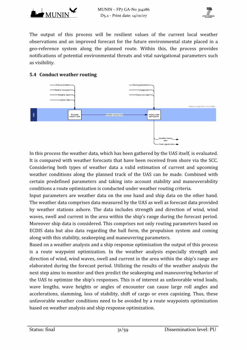
5.4 Conductweatherrouting
Inthisprocesstheweatherdata,whichhasbeengatheredbytheUASitself,isevaluated.It iscomparedwithweatherforecaststhathavebeenreceivedfromshoreviatheSCC.Considering both types of weather data a valid estimation of current and upcomingweather conditions along the planned track of the UAS can bemade. Combinedwithcertain predefined parameters and taking into account stability and maneuverabilityconditionsarouteoptimizationisconductedunderweatherroutingcriteria.Inputparametersareweatherdataon theonehandandshipdataon theotherhand.TheweatherdatacomprisesdatameasuredbytheUASaswellasforecastdataprovidedby weather stations ashore. The data includes strength and direction of wind, windwaves,swellandcurrentintheareawithintheship’srangeduringtheforecastperiod.Moreovershipdataisconsidered.ThiscomprisesnotonlyroutingparametersbasedonECDIS data but also data regarding the hull form, the propulsion system and comingalongwiththisstability,seakeepingandmaneuveringparameters.Basedonaweatheranalysisandashipresponseoptimizationtheoutputofthisprocessis a route waypoint optimization. In the weather analysis especially strength anddirectionofwind,windwaves,swellandcurrentintheareawithintheship’srangeareelaboratedduring the forecastperiod.Utilizing the resultsof theweatheranalysis thenextstepaimstomonitorandthenpredicttheseakeepingandmaneuveringbehavioroftheUAStooptimizetheship’sresponses.Thisisofinterestasunfavorablewindloads,wave lengths, wave heights or angles of encounter can cause large roll angles andaccelerations, slamming, loss of stability, shift of cargo or even capsizing. Thus, theseunfavorableweatherconditionsneedtobeavoidedbyaroutewaypointsoptimizationbasedonweatheranalysisandshipresponseoptimization.

MUNIN – FP7 GA‐No 314286
D5.2 ‐ Print date: 14/01/07
Status: final 32/59 Dissemination level: PU
The process output is a recommendation regarding optimized routewaypoints underconsiderationofcurrentandforecastweatherconditionsaswellasthecharacteristicsofthe UAS. Notification on the routing and its optimization possibilities are provided inorder to allow an adjustment of the track. The automated optimization of routewaypointscanhelptoincreasefuelefficiencyandtoensureasafeandsmoothvoyage.
5.5 Provideenginedata
Relevant data from the EAS is being forwarded to the appropriate bridge processes.Withinworkpackage6oftheMUNINprojectfurtherdetailsarebeingelaborated.Asmentionedinchapter5.1thespeedoftheshipisoneofitskeyvaluesfornavigatingandmaneuvering. Other important values for these tasks are for example the rudderangle,engineloadandfuelconsumption.Allthesevalueshaveincommonthattheyarerelated to parts of the engine room. The bridge is responsible for navigation andrequiresthiskeydatafromtheengineroomwhileitalsohastotargetthesevaluesfortheengineroom.Theengineroomdata isbasicallysplit into twoparts.The firstpartrefers to thedatasent fromthebridgeto theengineroom.Thesedataare ingeneralcontrolcommandsandtargetvalues.Thecontrolcommandsareusedtostartandstopcomponentslikethemain engine, auxiliary enginesorprocesses such as ballasting orbunkeringof fuel orwater.Thetargetedvaluesareforexamplethepropellerspeedortherudderangle.Thecommandswillbehandledby theAutonomousEngineMonitoringandControlsystemAEMC and then forwarded to the EAS. The other part of the data is related to themeasured values needed for bridge calculation and status reports. These sensorreadings of temperatures, pressures and filling levelswill be directly delivered to theautomationsystemandtheengineroomcontrollerwillprocessthereceivedvaluesfromthe EAS for the bridge. For general data sharing between bridge and engine room aninterfaceisrequiredwhichwillbedescribedinchapter7.2ofthisdocument.Asanoutput forthisconnectionbetweenthebridgeandtheengineroomtheABShastheabilitytonavigatetheshipandcontroltheneededpartsoftheengineroomsystems.InadditiontothistheABSreceivesinformationabouttheconditionofkeyengineroomvaluesandhasthepossibilitytoreactonupcomingsituationsearly.
5.6 Determineshipstatus
Theshipstatusprocesscollectsinformationwhichareneededtocontinuouslyestablishathoroughmotionmodeloftheshipanditsoperationalcondition.The current displacement, trim, heel, draft in forward, midship and aft position,translatoryshipmotionssuchassurge,swayandheaveaswellasrotatoryshipmotionssuch as roll, pitch and yaw are gathered from respective sensors. In addition, mainengine, steering gear and thrusters submit their status data to this process. For thepurposeofbuoyancyandstabilitycontroldataabouthullstressesandhullintegrityare

MUNIN – FP7 GA‐No 314286
D5.2 ‐ Print date: 14/01/07
Status: final 33/59 Dissemination level: PU
alsogathered.Furthermore, to calculateweightdistributionullagesofballast and fueltanksarecollectedwithinthisprocesswhiledataconcerningcargomonitoringwillhavetobesubmittedbytheSCCtoacertainextent.The main objective of this process lies in gathering, evaluating and distributing theavailable status sensor data. This is necessary to continuously assess the currentsituationof theshipunder theprevailingconditionsand topredict itsbehaviorunderpossiblefutureconditions.The data distributed is a set of information containing a detailedmodel of the ship’smovements alongwith the status of propulsion, steering, hull and cargo. Thiswill beusedtodeterminetheshipdynamicsandtocontrolitsbuoyancyandstability.
5.7 Determineshipdynamics
Withinthisprocessthebasis forplanningmaneuvers is tobe laidout. It isbasedonaship’smodelwhichmustbeassessedcontinuouslyonitsaccuracy.Thereforetheactualshipdynamicsmustbeidentifiedasexactlyaspossible.Theinformationcanbetakenfromtheship’sownsensorsystemwhereasthepositiondataandspeedcomponentsformthemost importantinformationforthisprocess.Forthe assessmentof the ship’smodelmeasurementsduring time lapsof relevant lengtharerequiredinordertoobtainresilienttimeseriesofthesedata.This dynamic data can be grouped into the different sets of information. The generalparameters consist of position, longitudinal and transversal speed over ground andthrough water, RoT, course, heading, roll and pitch angle, wind direction and force,currentdirectionandforce,waterdepth, engine mode and system time. The rudderparameters indicate the commanded and the actual rudder angle, the rudder pumpmodeandpossibleotherparameters forspecificruddertypes, ifrequired. Inasimilarway,thecommandedandtheactualvalueforanythrusteronboardareindicatedalongwithotherparametersforspecificthrustertypes.PropulsionparametersconsistoftheEOT, commanded and actual RpM or pitch, respectively as well as possible otherparametersforspecificpropulsionplants.Themainobjectiveof this process lies in the evaluation and redefinitionof the ship’smodel in order to be able to properly assess the situation in themaneuver planningprocess.The output will be the identification of the exact actual ship dynamics which arerequired todetermine the ship’smaneuverability. Thisonly enables realistic planningfor the execution of weather routing and collision avoidance. The following threeinformation sets should at all times be available and continuously be adapted to thecurrentsituationtoensurefastreactionincaseofemergency:
- Predictionof turningcircles toportandstarboarduntiladeviationof90° fromtheoriginalheadingisreached

MUNIN – FP7 GA‐No 314286
D5.2 ‐ Print date: 14/01/07
Status: final 34/59 Dissemination level: PU
- Predictionofcrashstopdistance
- Otherrequiredmaneuverstoensureadefinedship’sdomain
Thepresentableoutputparametersforthesevariouspredictedmaneuversarethesameas the above mentioned input parameters, but calculated for the future ship’smovement.
5.8 Controlautonomousship
TheSCCbridgecontrolplaysacentralrolewithintheoperationoftheUAS.ThecurrentsituationoftheUASisconstantlymonitoredbaseduponthedatareceivedviatheship’slogbookorviathereceiptofadirectnotification.AtalltimestheSCChasfullaccesstoUASdata,cansetparametersandenterrelevantinformation.FromaseparateSCCprocess,acompletevoyageplandocumentisreceivedforreviewandapproval.Buttothe largestextent, inputdataoriginates fromtheUASandmostlyfromthelogbookprocess.Standardinformationabouttheprogressofthevoyage,suchascoursessteered,distancessailed,positions fixed,embarkationsanddisembarkationaswellasothernotableeventsaresubmittedwithinastandardroutineinterval.Incaseof incidents occurring, separate notifications are received to provide informationconcerningweatherrouting,collisionavoidanceoremergencysituations.Theseincidentnotifications might include a request for assistance in solving a specific situation. Inadditiontothat,allvoiceradiocommunicationisrelayedtothehumanSCCoperator.This process serves as the central point for information exchange between ship andshore.Thedatapassingthroughisviewedbyanoperatortoallowanassessmentofthecurrentsituationonboard.Basedonthisassessmentandfurthercriteria,theSCCmighttakecorrectiveactionandintervenewithautonomousshipoperation.ThecontroloftheUASisconductedeitherbytheadjustmentofparametersfore.g.theship’s routingorby theprovisionof informationupdatesconcerningvoyageplanning,nauticalpublicationsandweatherforecasts.
5.9 Followtrack(autopilot)
The track laid out by the voyage plan and any adjustments theretomade byweatherrouting or collision avoidancemeasures are being carried out by the automatic trackpilotwithintheSCC‐setsteeringparameters.Steering parametersmust be pre‐setmanually and contain thresholds for radius andrateofturnforcoursechangesatwaypoints.Moderntrackpilotsdon’tjustcontroltheship’ssteeringbutalso itsspeedbyeitherasetallowanceoraset timeofarrivalatacertain position. Sensor input on the other hand comprises the ship’s position, speedthroughwaterandoverground,heading,RoTandtherudderangleindicatorvalue.Bycomparisonoftheactualwiththedesiredpositionvaluethetrackpilotcalculatesthecrosstrackdistance,whichisthedeviationfromtheplannedtrack.Analgorithmisthen

MUNIN – FP7 GA‐No 314286
D5.2 ‐ Print date: 14/01/07
Status: final 35/59 Dissemination level: PU
usedtodetermineandcompensateforanydisturbancevalues,accountingforallabovementionedsensorinputvalues.Adesiredrudderanglevalue isproducedasoutputdataandexecutedby thesteeringgear.Trackcontrolsystemsmustbecapabletokeepascloseas50meterstotheaspiredtrackwhile themostmodern systems barely produce an XTE ofmore than 10 to 20meters.
System Obligation Trigger Process word
Object Legal Regulations
The ABS must be capable to receive position, heading, rate of turn and speed of own ship (relevant for identification of deviation from course line)
MSC. 64(67) Annex 3
The ABS must be capable to receive own ships voyage plan (needed to identify planned actions e.g. change of course at waypoint and scheduled position and heading)
SOLAS Chapter V R34,
IMO Resolution A.893(21)
The ABS must be capable to receive information on the environmental conditions (in heavy sea deviations from scheduled course may not induce action as early)
SOLAS Chapter V R34,
IMO Resolution A.893(21)
The ABS must be capable to consider ships maneuvering characteristics IMO Resolution A.601(15)
MSC.137(76)
The ABS must evaluate own ship's true position and speed in comparison with the voyage plan
The ABS must identify deviation between planned and actual situation taking into account current environmental conditions
SOLAS Chapter V R34,
IMO Resolution A.893(21)
The ABS must evaluate when deviation becomes unacceptable STCW A‐VIII/2 Part 2 (7)
The ABS must evaluate if deviation can be made up for (small deviation) STCW A‐VIII/2 Part 2 (7)
The ABS must initiate action to return to planned situation / maneuvering status (if deviation is only small and can be made up for)
‐‐‐
The ABS must notify the SCC (if deviation from planned track gets significant)
‐‐‐
The ABS must initiate actions scheduled in the voyage plan (e.g. change of course at waypoint)
SOLAS Chapter V R34,
IMO Resolution A.893(21)
The ABS must offer SCC the possibility to
define parameters and thresholds relevant for following the planned track (e.g. what degree of deviation shall initiate an action)
‐‐‐
The ABS must be capable to receive orders (to steer and maneuver) STCW Table A‐II/4
The ABS must perform steering and steer and maneuver actions STCW B‐II/1 (11.4)
The ABS must identify if steering actions are carried out properly by the maneuvering equipment
MSC.74(69)
MSC.252(83)
The ABS must notify the SCC (if there is a problem with the steering gear)
‐‐‐
The ABS must offer SCC the possibility to
control steering and sailing actions ‐‐‐
The ABS must/shall … … … …
5.10 Controlbuoyancyandstability
Thisprocessreliesontheinformationabouttheprevailingsituationwhichisprovidedbytheshipstatusprocess.Thereuponthisprocessarrangesadequatemeasuresinordertoachieveasatisfactorybuoyancyandstability.The required information from the ship status process are the distribution ofmassesfromballastandfueltanksandcargoaswellastheship’strim,heelanddraftinforward,midshipandaftposition.Dataabouttheship’smotionwithinits6degreesoffreedomisrequiredaswell.

MUNIN – FP7 GA‐No 314286
D5.2 ‐ Print date: 14/01/07
Status: final 36/59 Dissemination level: PU
Thisprocessmustcarryoutacalculationuponabovementionedinformationtoassessthe current floating condition and, if thresholds are exceeded, to take adequatemeasuresincollaborationwithothershiptoolsfore.g.ballastorbunkeractivities.If situationdemands,measures toensure sufficientbuoyancyandstabilityare carriedout. Inanycaseastatus flagwill indicatethecurrentsituationandpossibleactionstotheSCC.
5.11 Avoidcollision
To navigate the UAS safely and COLREG‐compliant it is necessary to continuouslymonitor the current traffic situation.Todoso, all traffic‐relateddata is combinedandassessedwithinthissubprocessofcollisionavoidance.Possiblefuturedevelopmentsarebeing predicted and as soon as a potential close quarters situation is identified,appropriateCOLREGmeasuresarebeingtaken.To properly define the current traffic situation it is essential to ascertain the ship’spositiononanelectronicnavigationalchartwithfullinformationaccessibility.Inorderto predict the own ship’s movement, the full set of location and dynamics data isrequired as well. Additionally, the various data sets from both lookout processes areneeded.AtalltimestheSCChasanoverrulingfunctioninordertobeabletoadjustdatasettings e.g. risk parameters for ship domain or safety contour or to order specificevasivemaneuvers.This input data is then combined to establish a vision of the vicinity of the ship. Allidentified objects, e.g traffic ships, aids to navigation, floating debris or PiWs arediligentlymonitored.Theintendedroutesoftraffictargetshipsarepredicted,evaluatedandpossibleupcomingclosequarterssituationsareidentified.Incasesuchasituationoccurs it is clarifiedwhich ship is obliged to performwhat action under the COLREGregime,applyingthepropersetofrulesfortheprevailingvisibilityconditions.Oncetheown ship’s obligations have been identified possible solutions to this situation areelaboratedandassessed.Multiplesolutionsarecalculated,takingintoaccountpossiblemaneuversof thecollisioncandidateandavoidingclosequarterssituationswithotherships in the vicinity. The traffic situation needs to be continuously monitored and

MUNIN – FP7 GA‐No 314286
D5.2 ‐ Print date: 14/01/07
Status: final 37/59 Dissemination level: PU
assessedtobeabletoadopttomaneuversoftrafficships.Shouldnosuitablemeasurebeidentifiedtoavoidapendingcollision,assistancefromtheSCCwillberequested.An appropriate response to a specific traffic situation is identified, eithermaintainingsteadycourseandspeedortakingearlyandsubstantialactiontokeepwellclear.Thiscomprises specific measures in the form of orders for rudder angle and enginetelegraph.IncaseatrafficshipdoesnotcomplywithCOLREGsorbehavesinanunusualmanner, posing a threat to safety, a message may be transmitted, inquiring itsintentions.Insuchanevent,theSCCwillbenotifiedaswell.Also,allinformationaboutmaneuvers carried out by any ship involved must be shared with the SCC. If ademandingtrafficsituationshoulddeveloptheoutputdataisforwardedatahigherrate.It isalsoreported to theSCC if theclosequarterssituationhasbeenresolvedand theshipshavepassedwellclearofeachother.
5.12 Planvoyage
The voyage planning process is being performed to identify themost favorable routeunder routing criteria.Thepreparationofa thoroughplan fromberth toberth coversoceanpassages, coastalvoyagesandpilotagewaters. It isproducedashoreby theSCCandthenforwardedtotheUAS.Firstly, thespecificship’scharacteristicsneedtoberespectedas for itsstability,draft,trim,equipment,maneuverabilityandanyoperationallimitations.Also,thenatureoftheloaded cargo and its weight distribution and safe stowage need to be accounted for.Secondly,acompleteandup‐to‐datedocumentationofcertificates,nauticalpublicationsand sea charts is required. Thirdly, current information such as existing radionavigationalwarningsandweatherreportsfortherelevantseaareasneedtobeviewed.Fourthly, departure and arrival requirements for the respective ports are to beconsidered as well as ship routing and reporting measures within the transited seaareas. Fifthly, the ship’s provisions of fuel, lubricants and other supplies have to beverified.Onthebasisofaboveinformation,adetailedvoyageplanispreparedbytheSCCwhichcoverstheentirevoyage.Thisplanshouldlayoutthevoyagetrackandcontainalistofwaypoints,truecoursesofeachleg,legdistances,wheel‐overpositionsandturnradiusfor course alterations and maximum allowable off‐track margins. Additionally suchattributesasinformationaboutroutingandreportingsystemsandareaswhichrequirespecialconsiderationsinrespecttosafety,securityandenvironmentalprotectionshouldbe included. These elements comprise e.g. safe speed and potential speed alterations,permissible UKC, machinery status requirements, fuel bunker and range as well asfrequency and methods of position fixing. Furthermore, voyage planning aims forefficientshipoperationandthereforethemostfavorablepermissibleroutetosavetimeand fuel should be chosen. Especially for ocean transits the prevailing currents and

MUNIN – FP7 GA‐No 314286
D5.2 ‐ Print date: 14/01/07
Status: final 38/59 Dissemination level: PU
windshavetobeaccountedforinthisrespectandthecompliancewiththeLLChastobeascertained.As a voyage plan, a clear record should be produced, with all necessary informationmarked on the navigable sea charts andwritten in a document format accessible forhumansandABSalike.ThisrecordisthantransmittedtotheUASandcountercheckedbeforeimplementation.
System Obligation Trigger Process word
Object Legal Regulations
The ABS must consider changes / adjustments to the voyage plan during the voyage
STCW A‐VIII/2 Part 4 (7)
The ABS must ascertain voyage plan is in compliance with COLREGs COLREG
The ABS must consider corrections of nautical publications and sea charts that affect the current voyage plan properly
SOLAS Chapter V R19 2.1.4
The ABS must evaluate if the voyage plan is legitimate / valid / feasible STCW B‐II/1 (11.1.9)
The ABS must provide new voyage plan to other ABS processes ‐‐‐
The ABS must/shall … … … …
5.13 Conductlookout(traffic)
Withinthisprocessdatafromnavigationalandsafetysensorsiscollectedandassessedtobuildalocalmapofships,objectsandothernavigationalhazards.Theapproachfusesandcorrelatesdatafrommultiplesensorstoreduceoveralluncertaintyandimprovethequality and integrity of themap. This complete traffic picturewill be used to initiateactions or to notify the SCC. Voice radio communication is also handled within thisprocessandrelayedtotheSCC.Toenableathoroughlookout,ownship’sdatasuchasposition,heading,speedandUKCis needed in the first place. Then, navigational sensors on board the UAS constantlygatherdata togeneratea complete trafficpictureof thevicinityof the ship.Todo so,targetsaredetected,identifiedandtracked.ThistrafficassessmentissupportedbytheCCTVpicture.Theprocess receives input fromownvessel sensorsandotherABSandSCC modules. The main vessel sensors are the radar, for raw readings and ARPAinformation,AISforreportedvessellocationsandothersafetyinformation,NAVTEXfor

MUNIN – FP7 GA‐No 314286
D5.2 ‐ Print date: 14/01/07
Status: final 39/59 Dissemination level: PU
navigational and meteorological warnings, and infrared and daylight images forautomatedprocessinganddetectionofunknownhazards. Inaddition, theprocesswilluse a‐priori navigational chart data alongside weather, tide, depth and visibilityinformationtodetectpotentialnavigationalhazardsaheadoftime.Themain objective is to collect, process, verify andoutput observation of the currentandfuturenavigationalandvesseltrafficenvironmentaroundtheownship.Sensordataiscollectedatdifferentratesandwithvariousdegreeofaccuracy.Thisprocesswillfusethe observations by correlating related observations from different sensors. Thiswilleliminate wild points and statistical noise from the readings and provide a robustrepresentationofthecurrentandfuturetrafficsituationsurroundingtheship.The outputwill be a set of target data and features in the vicinity of the vesselwithpotential threatshighlighted.The sensor fusionprocess alsowill annotate each targetwithaconfidence levelbasedon thecorrelationsbetweendifferentsensor types.Thisprocess provides both a local map of the environment and warnings about potentialhazards based on the own ship current and predicted status and position as well asthoseoftheobjectsdetected.
5.14 ReceiveNAVTEXandSafetyNETdata
Maritime safety information which is being distributed through the NAVTEX andSafetyNETservice isreceivedbytheUASandforwardedtotheappropriateprocesses.As the transmission’s composition is not fully standardized it might be difficult tointerpretthemautomatically.These messages may consist of navigational and meteorological warnings,meteorologicalforecasts,SARandotherurgentinformation.Theinformationreceivedisbeinginterpretedanddistributedtoitsrespectivelookoutprocessforfurtheruse.The NAVTEX and SafetyNET data which is being distributed either to the lookout(weather)orlookout(traffic)processwillcontributetoestablishathoroughperceptionofthesurroundingoftheship.
5.15 Managealarmsandemergencies
All potential emergency situations are being managed within this process and areintendedtodrawattentiontoabnormalsituationsandconditions.Incaseapermissiblethresholdisexceededinanypartoftheship,analertmessagewillbe received by this process. There is a large quantity of possible indications formalfunctionsorabnormalconditionsofmachinerypartssuchasmainengine,auxiliaryengines, bilges, steering gear or electrical installations. Other alert messages can berelated to either navigation, cargo or personnel, e.g. engineers alarm or bridgenavigationalwatchalarm.Distressalertswillberaisedincasearespectivemessage isreceivedorifanindicationofdistresshasbeendetected.Anemergencysuchasfireor

MUNIN – FP7 GA‐No 314286
D5.2 ‐ Print date: 14/01/07
Status: final 40/59 Dissemination level: PU
leakage is indicated by a fire detection alarm and local fire‐extinguishing systemactivationalarmorawateringressdetectionalarmandpower‐operatedwatertightdoorfault alarm, respectively. Beyond that, an alert message notifies in case of faults ofcontrol systems.This list of alarm inputs continueswith further additional alarms forspecificshiptypessuchasgasdetectionalarmontankersforexample.Themainpurposeof thisprocess is to concentrate all ship alertmessageswithinonesystemtoprovidetheSCCwithasinglepointofaccess for themanagementofalarmsandemergencies.FromthiscentralizedmanagementsystemthealertmessageswillbeforwardedtotheSCCandindicateastatuschangeoftheship.Dependingontheseverityofthealarmsandthepossibleorexpectedconsequencesoftheprevailingsituation,furtheralarmswillberaisedonboard,e.g.generalemergency,fire,abandonshiporshipsecurityalarm.Thesealarmsmaybeaccompaniedbytheemissionofdistress,urgencyorsafetymessagesviatheGMDSSnetwork.Furthermore,specificcountermeasurescanbetakenautomaticallybytheUAStocopewiththeprevailingsituation.Thesemeasuresmaycompriseachangeoftheship’soperationalmodeandthedeterminationandexecutionofappropriateFail‐to‐SafeFtSorSARprocedures.
5.16 ReceiveAISdata
Datarelevanttopromotethesafetyofnavigationbyfacilitatingtracking,identifyingandlocatingisreceivedfromotherAIStransceiversinthevicinity.Depending on the emitting ship’s speed the different AIS messages are broadcastedevery 2 to 10 seconds, every 3minutes or every 6minutes. Thismessages consist ofstatic ship’s data such as its IMO‐ and MMSI‐number, name, type, call sign anddimensions.Dynamicship’sdatasuchasnavigationalstatus,positionwithtime,courseandspeedoverground,headingandRoT isalsotransmitted.Additionallyvoyagedatalikecurrentdraft,hazardouscargo,portofcall,estimatedtimeofarrivalandthenumberofcrewonboardaretobebroadcasted.The input data of up to 500 ships is gathered and updated individually within thetransceiver. In case this number should be exceeded, those targets with the greatestdistancefromtheownshipwillberejectedbythesystem.ThusacompleteoverviewofAIStargetswithinarangefrom20nmto30nmisestablished.InseaareasinwhichAISrepeaterstationsarefitted,thisrangecanbeenlargedbeyondthat.This trafficoverview is forwarded to the conduct lookout (traffic)process tobe fusedtogether with other input data to form an even more thorough and more completeoverviewofthetrafficinthevicinityofthevessel.

MUNIN – FP7 GA‐No 314286
D5.2 ‐ Print date: 14/01/07
Status: final 41/59 Dissemination level: PU
6. SpecificationrequirementsfortheAutonomousBridgeSystem
6.1 Determineposition,heading,speedanddepth
In thisprocessdata fromvarious ship’s sensors is gatheredandevaluated inorder tothoroughly determine the position and heading of the ship. Redundant sensors andpositioning by multiple sources ensure a high degree of data accuracy. The currentspeed and water depth is determined as well. The legal foundation for theserequirements can mainly be found within SOLAS, STCW, COLREG and several IMOresolutions.System Obligation Trigger Process word Object Legal regulations
The ABS
must be capable to receive data from own ship sensors (compass) SOLAS Chapter V R19 2.1.1 MSC.252(83)
The ABS
must determine compass error SOLAS Chapter V R19 2.1.3
STCW B‐II/1 (11.1.5)
The ABS
must perform correction of compass error (if compass error is identified)
SOLAS Chapter V R19 2.1.3
STCW B‐II/1 (11.1.5 &
11.1.8)
STCW A‐VIII/2 Part 4‐1
(34.2)
The ABS
must be capable to receive data from own ship sensors (speed log data) SOLAS Chapter V R19 2.3.4
MSC.252(83)
The ABS
must be capable to receive data from own ship sensors (radio navigation data) SOLAS Chapter V R19 2.1.6
MSC.252(83)
The ABS
must be capable to receive data from own ship sensors (radar/ARPA navigation data)
COLREG R5/R6/R7/R19
SOLAS Chapter V R19
2.3.2/2.3.3/2.7
MSC.64(67) Annex 4
MSC.252(83)
STCW B‐II/1 (11.3)
The ABS
must be capable to receive data from own ship sensors (GNSS) SOLAS Chapter V R19 2.1.6
MSC.252(83)
The ABS
must be capable to receive data from own ship sensors (automatic sextant: position of celestial bodies)
STCW B‐II/1 (11.1.7)
The ABS
must evaluate data from own ship sensors (to determine position and heading)
STCW B‐II/1 (11.2)
MSC.252(83)
The ABS
must calculate own ships position and heading by more than one method (including terrestrial, celestial and technical navigation techniques)
STCW Table A‐II/1
The ABS
must evaluate own ships position depending on different methods of positioning
STCW Table A‐II/1
The ABS
must identify deviations of own ships position calculated by different methods
STCW Table A‐II/1
The ABS
must notify the SCC (if ambiguity of own ship's position is found) ‐‐‐
The ABS
must calculate own ships movements based on data from own ship sensors (speed, acceleration, heading, roll, pitch, yaw, surge, sway, heave)
STCW A‐VIII/2 Part 4‐1
(25)
The ABS
must provide information on own ships position, heading and movement to other ABS processes
SOLAS Chapter V R28 (2)
The ABS
must offer SCC the possibility to
access information on position and heading of own ship SOLAS Chapter V R28 (2)
The ABS
must be capable to receive data from own ship sensors (echo sounder) SOLAS Chapter V R19 2.3.1

MUNIN – FP7 GA‐No 314286
D5.2 ‐ Print date: 14/01/07
Status: final 42/59 Dissemination level: PU
System Obligation Trigger Process word Object Legal regulations
The ABS
must calculate current under‐keel clearance (Obs tide differences) STCW A‐VIII/2 Part 5‐3
(102.2.2)
The ABS
must detect insufficient under‐keel clearance (Need to be predictive)
STCW A‐VIII/2 Part 5‐3
(102.2.2)
The ABS
shall monitor all sensors STCW A‐VIII/2 Part 4‐1
(17.9 & 18.7)
The ABS
shall determine an appropriate response (if a sensor failure should be encountered)
STCW Tabel A‐VII/1 & A‐
VII/2
The ABS
must provide a time frame for the data that is forwarded to the SCC or to other ABS processes
‐‐‐
The ABS
must/shall … … … …
6.2 Conductlookout(weather)
Inthisprocess,theUASindependentlygathersweatherdatafromitsownsensors.Itisits purpose to establish a thorough perception of the current environmentalsurroundingoftheship.TheaccumulateddataisusedforsubsequentweatherroutingandisalsostoredandprovidedtotheSCC.ThelegalfoundationfortheserequirementscanmainlybefoundwithinCOLREGs,SOLAS,STCWandseveralIMOresolutions.
Subprocess System Obligation Trigger Process word
Object Legal regulations
Measure weather data
The ABS must be capable to
receive data from own ship meteorological sensors
STCW Table A‐II/1 and Table A‐II/2
Measure weather data
The ABS must be capable to
consider Radar/ARPA information (to identify current sea state)
COLREG R6 a)v
SOLAS Chapter V R19
2.3.2/2.3.3/2.7
Measure weather data
The ABS must identify current sea state information STCW A‐VIII/2 Part 4‐1
(16.2 & 17.1)
Measure weather data
The ABS must detect areas of limited visibility COLREG R19
Provide CCTV picture
The ABS must be capable to
consider
CCTV information (to capture current environmental condition, e.g. visibility, cloud picture and movement, sea state)
‐‐‐
Assess weather data
The ABS must evaluate information about the environment from all available sources to define the current environmental condition
SOLAS Chapter V R34,
IMO Resolution A.893(21)
Assess weather data
The ABS must be capable to
consider
own ship meteorological observation system information (e.g. air and water temperature, atmospheric humidity, atmospheric pressure, wind characteristics)
SOLAS Chapter V R5 2.4
Assess weather data
The ABS must provide meteorological information to other ABS processes
SOLAS Chapter V R5 2.5
Assess weather data
The ABS must
offer SCC the possibility to
access information on possible upcoming and current threats
SOLAS Chapter V R34 (2),
IMO Resolution A.893(21)
Assess weather data
The ABS must provide a time frame for the data that is forwarded to the SCC or to other ABS processes
‐‐‐
… The ABS must/shall … … … …
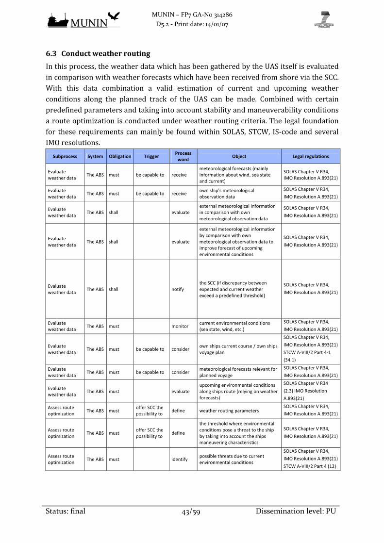
MUNIN – FP7 GA‐No 314286
D5.2 ‐ Print date: 14/01/07
Status: final 43/59 Dissemination level: PU
6.3 Conductweatherrouting
Inthisprocess,theweatherdatawhichhasbeengatheredbytheUASitselfisevaluatedincomparisonwithweatherforecastswhichhavebeenreceivedfromshoreviatheSCC.With this data combination a valid estimation of current and upcoming weatherconditions along the planned track of the UAS can be made. Combined with certainpredefinedparametersandtakingintoaccountstabilityandmaneuverabilityconditionsarouteoptimizationisconductedunderweatherroutingcriteria.Thelegal foundationfor these requirements canmainlybe foundwithinSOLAS, STCW, IS‐codeandseveralIMOresolutions.
Subprocess System Obligation Trigger Process word
Object Legal regulations
Evaluate weather data
The ABS must be capable to receive meteorological forecasts (mainly information about wind, sea state and current)
SOLAS Chapter V R34, IMO Resolution A.893(21)
Evaluate weather data
The ABS must be capable to receive own ship's meteorological observation data
SOLAS Chapter V R34,
IMO Resolution A.893(21)
Evaluate weather data
The ABS shall evaluate external meteorological information in comparison with own meteorological observation data
SOLAS Chapter V R34,
IMO Resolution A.893(21)
Evaluate weather data
The ABS shall evaluate
external meteorological information by comparison with own meteorological observation data to improve forecast of upcoming environmental conditions
SOLAS Chapter V R34,
IMO Resolution A.893(21)
Evaluate weather data
The ABS shall notify the SCC (if discrepancy between expected and current weather exceed a predefined threshold)
SOLAS Chapter V R34,
IMO Resolution A.893(21)
Evaluate weather data
The ABS must monitor current environmental conditions (sea state, wind, etc.)
SOLAS Chapter V R34,
IMO Resolution A.893(21)
Evaluate weather data
The ABS must be capable to consider own ships current course / own ships voyage plan
SOLAS Chapter V R34,
IMO Resolution A.893(21)
STCW A‐VIII/2 Part 4‐1
(34.1)
Evaluate weather data
The ABS must be capable to consider meteorological forecasts relevant for planned voyage
SOLAS Chapter V R34,
IMO Resolution A.893(21)
Evaluate weather data
The ABS must evaluate upcoming environmental conditions along ships route (relying on weather forecasts)
SOLAS Chapter V R34
(2.3) IMO Resolution
A.893(21)
Assess route optimization
The ABS must offer SCC the possibility to
define weather routing parameters SOLAS Chapter V R34,
IMO Resolution A.893(21)
Assess route optimization
The ABS must offer SCC the possibility to
define
the threshold where environmental conditions pose a threat to the ship by taking into account the ships maneuvering characteristics
SOLAS Chapter V R34,
IMO Resolution A.893(21)
Assess route optimization
The ABS must identify possible threats due to current environmental conditions
SOLAS Chapter V R34,
IMO Resolution A.893(21)
STCW A‐VIII/2 Part 4 (12)

MUNIN – FP7 GA‐No 314286
D5.2 ‐ Print date: 14/01/07
Status: final 44/59 Dissemination level: PU
Subprocess System Obligation Trigger Process word
Object Legal regulations
Assess route optimization
The ABS must identify possible threats due to upcoming (predicted) environmental conditions
SOLAS Chapter V R34
(2.3)
IMO Resolution A.893(21)
STCW A‐VIII/2 Part 2 (7)
Assess route optimization
The ABS must initiate
actions (if threats along the planned route of own ship related to upcoming environmental conditions are identified)
SOLAS Chapter V R34,
IMO Resolution A.893(21)
Assess route optimization
The ABS must initiate actions (if threats related to current environmental conditions are identified)
SOLAS Chapter V R34,
IMO Resolution A.893(21)
Assess route optimization
The ABS shall offer SCC the possibility to
define routing parameters / restrictions (time of arrival fix or time frame, minimize cost etc.)
SOLAS Chapter V R34,
IMO Resolution A.893(21)
Assess route optimization
The ABS shall be capable to consider
own ship's stability properties (to take them into account when calculating optimal route in the expected environmental circumstances)
SOLAS Chapter V R34,
IMO Resolution A.893(21)
IS Code Res.A.749 (18)
MSC/Circ.920
Assess route optimization
The ABS shall be capable to consider
own ship's maneuvering properties (to take them into account when calculating optimal route in the expected environmental circumstances)
SOLAS Chapter V R34,
IMO Resolution A.893(21)
Assess route optimization
The ABS shall be capable to access current voyage plan
SOLAS Chapter V R34,
IMO Resolution A.893(21)
STCW A‐VIII/2 Part 2 (6)
Assess route optimization
The ABS shall evaluate alternative routes under routing restrictions
SOLAS Chapter V R34,
IMO Resolution A.893(21)
Assess route optimization
The ABS shall determine whether alternative routes are favorable enough to justify a route change
SOLAS Chapter V R34,
IMO Resolution A.893(21)
STCW A‐VIII/2 Part 2 (7)
Assess route optimization
The ABS shall perform an adjustment of the route (if alternative route is found favorable)
SOLAS Chapter V R34,
IMO Resolution A.893(21)
Assess route optimization
The ABS shall notify the SCC (if an alternative route is found favorable and route is adjusted)
SOLAS Chapter V R34,
IMO Resolution A.893(21)
Assess route optimization
The ABS must be capable to evaluate the consequences that deviations from the planned track might have on the further voyage
SOLAS Chapter V R34,
IMO Resolution A.893(21)
STCW A‐VIII/2 Part 2 (7)
Assess route optimization
The ABS must provide information on weather routing recommendation to other ABS processes
SOLAS Chapter V R34,
IMO Resolution A.893(21)
IS Code Res.A.749 (18)
MSC/Circ.920
Assess route optimization
The ABS must provide a time frame for the data that is forwarded to the SCC or to other ABS processes
‐‐‐
… The ABS must/shall … … … …
6.4 Determineshipstatus
Fortheappropriatedeterminationofthestatusoftheship,therequireddataisgatheredwithin this process. Some data such as position, heading, speed and depth aswell asweather data is generatedwithin processes of their own. That’swhy ship status dataonlycomprisesdisplacement,draft,trim,shipmotionswithin6degreesoffreedomand

MUNIN – FP7 GA‐No 314286
D5.2 ‐ Print date: 14/01/07
Status: final 45/59 Dissemination level: PU
informationaboutpropulsionandsteeringsystems.Cargomonitoringisalsopartoftheship statusprocess. The legal foundation for these requirements canmainly be foundwithinSOLAS,STCW,CSS‐code,IS‐code,severalIMOresolutionsandcircularsaswellasine.g.nationalGermanlegislation.
System Obligation Trigger Process word
Object Legal Regulations
The ABS must calculate specific ships variable characteristics (e.g. displacement, draft, trim, ship’s movement )
IS Code Res.A.749 (18)
MSC/Circ.920
The ABS must be capable to receive technical data from other ship systems (current status of e.g. the engine, ballast system, fuel)
SOLAS Chapter II‐1 Part C
R51
STCW A‐VIII/2 Part 4‐1
(17.9 & 18.7)
The ABS must offer SCC the possibility to
transmit cargo‐related data to the ship HGB §535 (2) (German law)
The ABS must monitor cargo spaces to identify shift of cargo and further dangers such as fire, ect.
IMO Resolution A.714(17)
SOLAS Chapter II‐2 Part C
R7
The ABS must be capable to ascertain the save loading, lashing and care of cargo during the voyage
IMO Resolution A.714(17)
CSS Code Annex 13
The ABS must be capable to control the cargo hold meteorology HGB §535 (1) & HGB §606
(German law)
The ABS must be capable to detect defects and damages to cargo and ship's hull STCW Table A‐II/1
The ABS must/shall … … … …
6.5 Determineshipdynamics
Inordertosafelynavigatethedynamicsoftheshiphavetobedeterminedcontinuously.Ownship’scharacteristicshavetobeaccountedforaswellasenvironmentalconditions.ThelegalfoundationfortheserequirementscanmainlybefoundwithinSOLAS,STCW,COLREGs,IS‐codeandseveralIMOresolutions.
System Obligation Trigger Process word
Object Legal regulations
The ABS must be capable to receive current sea charts (to be able to identify impact of shallow or narrow waters on maneuvering properties)
STCW A‐VIII/2 Part 2 (5)
The ABS must be capable to receive current water depth from echo sounder (to be able to identify impact of shallow or narrow waters on maneuvering properties)
SOLAS Chapter V R19 2.3.1
The ABS must be capable to receive information on environmental conditions STCW A‐VIII/2 Part 4‐1
(16.2)
The ABS must be capable to receive further navigational data (course over ground, heading, position, speed, under‐keel clearance)
IMO Resolution A.601(15)
MSC.137(76)
The ABS must be capable to receive current stability conditions IS Code Res.A.749 (18)
MSC/Circ.920
The ABS must initiate a calibration by performing likely maneuvers IMO Resolution A.601(15)
MSC.137(76)
The ABS shall learn from maneuvers previously carried out to improve its calibration
IMO Resolution A.601(15)
MSC.137(76)
The ABS must consider the effects of wind, sea state and current on own ships maneuvering properties
IMO Resolution A.601(15)
MSC.137(76)
The ABS must consider the effects of shallow or narrow waters STCW Table A‐II/2
The ABS must consider possible restrictions on own ships maneuvering abilities (if e.g. engine availability is restricted)
COLREG R6 a)iii
The ABS must consider specific constant ship characteristics (e.g. dimensions)
IMO Resolution A.601(15)
MSC.137(76)

MUNIN – FP7 GA‐No 314286
D5.2 ‐ Print date: 14/01/07
Status: final 46/59 Dissemination level: PU
System Obligation Trigger Process word
Object Legal regulations
The ABS must determine constantly the ships maneuvering characteristics IMO Resolution A.601(15)
MSC.137(76)
The ABS must determine own ships maneuvering characteristics under different conditions (e.g. speed, sea state, water depth)
IMO Resolution A.601(15)
MSC.137(76)
The ABS must provide own ships maneuvering characteristics to other ABS processes
IMO Resolution A.601(15)
MSC.137(76)
The ABS must offer SCC the possibility to
access own ships current maneuvering characteristics IMO Resolution A.601(15)
MSC.137(76)
The ABS must provide a time frame for the data that is forwarded to the SCC or to other ABS processes
‐‐‐
The ABS must/shall … … … …
6.6 Controlbuoyancyandstability
Withinthisprocess,theweightdistributiononboardtheUASiscalculatedtodetermineandcontroltheship’sbuoyancyandstability.TherequireddataiseithergeneratedbyshipboardsensorsorreceivedfromtheSCC.Tobalanceunevenweightdistributionandtoensuresufficientstabilityballastoperationsarecarriedout.Thelegalfoundationforthese requirements canmainlybe foundwithinCSS‐code, IS‐code,BWM‐regulationaswellaswithinseveralIMOresolutionsandcirculars.
System Obligation Trigger Process word
Object Legal Regulations
The ABS must be capable to control actual drafts, trim, heel, stability and stress of the vessel (calculation of stability relevant parameters (e.g. GM) and comparison to their thresholds)
IS Code Res.A.749 (18)
MSC/Circ.920
The ABS must calculate constantly the ships stability and displacement status
IS Code Res.A.749 (18)
MSC/Circ.920
The ABS must provide stability information to other ABS processes IS Code Res.A.749 (18)
MSC/Circ.920
The ABS must be capable to initiate countermeasures to dangerous changes in cargo and stability condition
IMO Resolution A.714(17)
Chapter 7
IS Code Res.A.749 (18)
MSC/Circ.920
The ABS must notify the SCC (if the ships stability and displacement status can’t be calculated)
‐‐‐
The ABS must notify the SCC (if the maneuvering characteristics can’t be determined)
‐‐‐
The ABS must be capable to notify the SCC (if defects and damages to cargo and ship's hull have been detected)
‐‐‐
The ABS must notify the SCC (if the maneuvering characteristics can‘t be forwarded to other ABS processes)
‐‐‐
The ABS must notify the SCC (if the current stability of the ship changes considerably without a change in ballast)
‐‐‐

MUNIN – FP7 GA‐No 314286
D5.2 ‐ Print date: 14/01/07
Status: final 47/59 Dissemination level: PU
System Obligation Trigger Process word
Object Legal Regulations
The ABS must notify the SCC (if an increasing displacement indicates a water inrush)
‐‐‐
The ABS must notify the SCC (if the current stability of the ship reaches stability limits)
‐‐‐
The ABS must receive necessary data to calculate stability (loading and ballast condition, draft, trim, heel, …)
IS Code Res.A.749 (18)
MSC/Circ.920
The ABS must be capable to control
the ballast water management (if cargo condition changes, e.g. due to changing cargo hold meteorology, fuel consumption or damage to ship's hull)
BWM Regulation A until E
The ABS must be capable to ascertain compliance with ballast water requirements BWM Regulation A until E
The ABS must provide a time frame for the data that is forwarded to the SCC or to other ABS processes
‐‐‐
The ABS must/shall … … … …
6.7 Avoidcollision
To navigate the UAS safely and COLREG‐compliant it is necessary to continuouslymonitor the current traffic situation.Todoso, all traffic‐relateddata is combinedandassessedwithinthisprocessandpossible futuredevelopmentsarebeingpredicted.Assoonasapotentialclosequarterssituationisidentified,appropriatemeasuresarebeingtaken.ThelegalfoundationfortheserequirementscanmainlybefoundwithinCOLREGsbut also in SOLAS, STCW, IS‐code, bridge procedure guides as well as several IMOresolutionsandcirculars.
Subprocess System Obligation Trigger Process word
Object Legal Regulations
Monitor traffic situation
The ABS must offer SCC the possibility to
define parameters ‐‐‐
Monitor traffic situation
The ABS must be capable to access information about the surrounding area via the ENC
MSC.252(83)
Monitor traffic situation
The ABS must be capable to receive own ship's meteorological data STCW A‐VIII/2 Part 4‐1
(16.2)
Monitor traffic situation
The ABS must be capable to receive own ship's traffic target data STCW A‐VIII/2 Part 4‐1
(16.2)
Monitor traffic situation
The ABS must monitor objects in vicinity (e.g. ships, aids to navigation, floating debris, PIWs)
STCW A‐VIII/2 Part 4‐1
(16.2)
Monitor traffic situation
The ABS shall identify abnormal activity by ships in vicinity (e.g., gaining on own ship, not following COLREGs)
COLREG R17 a)ii, R2
Monitor traffic situation
The ABS must evaluate upcoming development of traffic situation
SOLAS Chapter V R34,
IMO Resolution
A.893(21)
Monitor traffic situation
The ABS shall evaluate intended routes of other ships based on AIS and ENC information available
SOLAS Chapter V R19
2.4
Monitor traffic situation
The ABS can evaluate intended routes of other ships based on visual and radar information
COLREG R5/R6 b)v

MUNIN – FP7 GA‐No 314286
D5.2 ‐ Print date: 14/01/07
Status: final 48/59 Dissemination level: PU
Subprocess System Obligation Trigger Process word
Object Legal Regulations
Monitor traffic situation
The ABS must offer SCC the possibility to
define parameters relevant to avoid close quarters situations
‐‐‐
Monitor traffic situation
The ABS must identify possible upcoming close quarters situations
COLREG R5
Monitor traffic situation
The ABS must notify the SCC (if a close quarters situation is developing)
‐‐‐
Monitor traffic situation
The ABS must offer SCC the possibility to
access information about upcoming close quarters situations and proposed safe deviation routes
COLREG R8
Monitor traffic situation
The ABS shall offer OBP the possibility to
access information about the upcoming close quarters situation
COLREG R7
Monitor traffic situation
The ABS must provide information about the current traffic situation to other ABS processes
COLREG R6 a)ii
Take COLREG measures
The ABS must be capable to receive own ship's stability data IS Code Res.A.749 (18)
MSC/Circ.920
Take COLREG measures
The ABS must be capable to receive own ship's maneuverability data COLREG R6 a)iii
Take COLREG measures
The ABS must transmit the traffic picture to the SCC COLREG R5/R6 b)v
Take COLREG measures
The ABS shall transmit parameters at higher update rates to SCC (if collision avoidance activities are performed)
‐‐‐
Take COLREG measures
The ABS must consider COLREGs while navigating COLREG R1 a
Take COLREG measures
The ABS must be capable to evaluate which collision avoidance rules apply under the prevailing visibility conditions
COLREG R7
Take COLREG measures
The ABS must identify if own ship is give‐way ship or stand‐on ship
COLREG R16/17
Take COLREG measures
The ABS must ascertain
possible solutions to avoid upcoming close quarters situations in compliance with COLREGs (if a danger of collision is identified)
COLREG
Take COLREG measures
The ABS shall calculate a relative waypoint to pass the stand‐on ship clear astern (if own ship is not the stand‐on ship)
COLREG R15
Take COLREG measures
The ABS must provide solutions for upcoming collision situations to other ABS processes (if a danger of collision is identified)
COLREG
R9/10/13/14/15/19
Take COLREG measures
The ABS shall notify the SCC (if abnormal activity by other ships is identified that might pose a threat)
(BPG 1.3.1)
Take COLREG measures
The ABS must notify the SCC (if an appropriate collision avoidance maneuver has been identified)
(BPG 1.3.1)
Take COLREG measures
The ABS must notify the SCC (if the system requires assistance in finding a valid solution to avoid pending collision)
(BPG 1.3.1)

MUNIN – FP7 GA‐No 314286
D5.2 ‐ Print date: 14/01/07
Status: final 49/59 Dissemination level: PU
Subprocess System Obligation Trigger Process word
Object Legal Regulations
Take COLREG measures
The ABS must initiate action (if an imminent collision situation arises)
COLREG R7
Take COLREG measures
The ABS must notify the SCC (if an imminent collision situation arises)
COLREG R7
Take COLREG measures
The ABS must perform a steady course and speed (if the unmanned ship is the stand‐on ship)
COLREG R17
Take COLREG measures
The ABS must detect an avoidance maneuver of the other ship
COLREG R5
Take COLREG measures
The ABS must notify the SCC (if an avoidance maneuver of the other ship is detected)
‐‐‐
Take COLREG measures
The ABS shall transmit a message to another ship to keep well clear (if the system doesn't detect an avoidance maneuver of the other ship)
‐‐‐
Take COLREG measures
The ABS must notify the SCC (if other ship does not act according to COLREGs)
‐‐‐
Take COLREG measures
The ABS shall transmit a message to other ships about its intentions (if an evasive maneuver is being performed)
COLREG R34
Take COLREG measures
The ABS must notify the SCC (if the other ship has been passed well clear and the close quarters situation has been resolved)
‐‐‐
Take COLREG measures
The ABS must offer SCC the possibility to
define a specific collision avoidance maneuver, besides the one found by the ABS
COLREG R8
Take COLREG measures
The ABS must offer SCC the possibility to
initiate a restriction of the "maneuver of the last moment"‐function (if pilot boats, tug boats or similar are approaching)
COLREG R17 b
Take COLREG measures
The ABS must provide a time frame for the data that is forwarded to the SCC or to other ABS processes
‐‐‐
… The ABS must/shall … … … …
6.8 Conductlookout(traffic)
Navigational sensorsonboard theUAS constantly gatherdata to generate a completetrafficpictureofthevicinityoftheship.Todosoobjectsarebeingdetected, identifiedand tracked. This traffic assessment is supported by the CCTV picture. The legalfoundationfortheserequirementscanmainlybefoundwithinSOLAS,STCW,COLREGsandseveralIMOresolutions.
Subprocess System Obligation Trigger Process word
Object Legal Regulations
Provide radar/ARPA picture
The ABS must be capable to
receive data from own ship sensors (radar/ARPA)
SOLAS Chapter V R19 2.3.2/2.3.3/2.7
Provide radar/ARPA picture
The ABS must be capable to
receive information about ships and objects in own ships vicinity by radar/ARPA
SOLAS Chapter V R19
2.3.2/2.3.3/2.7
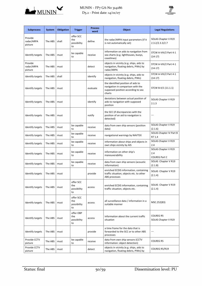
MUNIN – FP7 GA‐No 314286
D5.2 ‐ Print date: 14/01/07
Status: final 50/59 Dissemination level: PU
Subprocess System Obligation Trigger Process word
Object Legal Regulations
Provide radar/ARPA picture
The ABS shall
offer SCC the possibility to
define the radar/ARPA input parameters (if it is not automatically set)
SOLAS Chapter V R19
2.3.2/2.3.3/2.7
Identify targets The ABS must be capable to
receive information on aids to navigation from sea charts (e.g. lighthouses, buoys, coastlines)
STCW A‐VIII/2 Part 4‐1
(14‐17)
Provide radar/ARPA picture
The ABS must detect objects in vicinity (e.g. ships, aids to navigation, floating debris, PIWs) by radar/ARPA
STCW A‐VIII/2 Part 4‐1
(14‐17)
Identify targets The ABS shall identify objects in vicinity (e.g. ships, aids to navigation, floating debris, PIWs)
STCW A‐VIII/2 Part 4‐1
(14‐17)
Identify targets The ABS must evaluate
the identified position of aids to navigation in comparison with the supposed position according to sea charts
STCW B‐II/1 (11.1.1)
Identify targets The ABS must identify deviations between actual position of aids to navigation with supposed position
SOLAS Chapter V R19
2.1.3
Identify targets The ABS must notify the SCC (if discrepancies with the position of an aid to navigation is detected)
‐‐‐
Identify targets The ABS must be capable to
receive data from own ship sensors (position data)
SOLAS Chapter V R19
(2.1.6)
Identify targets The ABS must be capable to
receive navigational warnings by NAVTEX SOLAS Chapter IV Part B
R7 1.4
Identify targets The ABS must be capable to
receive information about ships and objects in own ships vicinity by AIS
SOLAS Chapter V R19
2.4
Identify targets The ABS must be capable to
receive information on other ship's maneuverability
SOLAS Chapter V R19
2.4
COLREG Part C
Identify targets The ABS must be capable to
receive data from own ship sensors (acoustic information)
SOLAS Chapter V R19
(2.1.8)
Identify targets The ABS must provide enriched ECDIS information, containing traffic situation, objects etc. to other ABS processes
SOLAS Chapter V R19
(2.1.4)
Identify targets The ABS must
offer SCC the possibility to
access enriched ECDIS information, containing traffic situation, objects etc.
SOLAS Chapter V R19
(2.1.4)
Identify targets The ABS must
offer SCC the possibility to
access all surveillance data / information in a suitable manner
MSC.252(83)
Identify targets The ABS must
offer OBP the possibility to
access information about the current traffic situation
COLREG R5
SOLAS Chapter V R19
Identify targets The ABS must provide a time frame for the data that is forwarded to the SCC or to other ABS processes
‐‐‐
Provide CCTV picture
The ABS must be capable to
receive data from own ship sensors (CCTV information: object detection)
COLREG R5
Provide CCTV picture
The ABS must detect objects in vicinity (e.g. ships, aids to navigation, floating debris, PIWs) by
COLREG R5/R19

MUNIN – FP7 GA‐No 314286
D5.2 ‐ Print date: 14/01/07
Status: final 51/59 Dissemination level: PU
Subprocess System Obligation Trigger Process word
Object Legal Regulations
CCTV
Provide CCTV picture
The ABS must be capable to
evaluate information about ships and objects in own ships vicinity by visual means (CCTV)
COLREG
Relay voice radio
The ABS must/shall be capable to
receive Radio messages SOLAS Chapter IV Part C
R6.3/R12
Relay voice radio
The ABS must/shall be capable to
evaluate Radio messages SOLAS Chapter IV Part C
R6.3/R12
Relay voice radio
The ABS must/shall be capable to
transmit Radio messages
SOLAS Chapter IV Part C
R6.3/R12
STCW B‐II/1 (11.9)
… The ABS must/shall … … … …
6.9 Managealarmsandemergencies
Situationswhich are potentially threatening the safety of the ship are beingmanagedwithin this processwith strong connections to the SCC and otherUAS processes. ThelegalfoundationfortheserequirementscanmainlybefoundwithinSOLAS,STCW,ISM‐code,IAMSAR,andseveralIMOresolutions.
Subprocess System Obligation Trigger Process word
Object Legal Regulations
SAR The ABS must
offer SCC the possibility to
initiate SAR mode SOLAS Chapter V R33
SAR The ABS must be capable to
perform within a SAR operation according to IAMSAR
SOLAS Chapter V R33
IAMSAR
SAR The ABS must be capable to
perform search pattern SOLAS Chapter V R33
IAMSAR
SAR The ABS must initiate search mode SOLAS Chapter V R33
IAMSAR
SAR The ABS must provide information on the results of the search to SCC (if SAR is initiated)
SOLAS Chapter V R33
(1)
IAMSAR
SAR The ABS shall provide live video stream to SCC (if SAR is initiated)
‐‐‐
FtS The ABS must be capable to
receive a request for FtS action from other ABS processes
‐‐‐
FtS The ABS must evaluate the situation continuously regarding the necessity to initiate a FtS procedure
‐‐‐
FtS The ABS must determine the appropriate FtS procedure ‐‐‐
FtS The ABS must initiate FtS continue on course with ∙ safe (reduced) speed (if found appropriate)
‐‐‐
FtS The ABS must initiate FtS fix position maneuver (if found appropriate)
??
FtS The ABS must initiate FtS emergency brake maneuver (if found appropriate)
SOLAS Chapter II‐1 Part
C R28
FtS The ABS must initiate FtS emergency anchoring maneuver (if found appropriate)
FtS The ABS must initiate other FtS procedure (if found appropriate)
‐‐‐

MUNIN – FP7 GA‐No 314286
D5.2 ‐ Print date: 14/01/07
Status: final 52/59 Dissemination level: PU
Subprocess System Obligation Trigger Process word
Object Legal Regulations
FtS The ABS must notify the SCC ‐‐‐
FtS The ABS must transmit commands to other ABS processes to carry out FtS (if FtS is initiated)
‐‐‐
FtS The ABS must
offer SCC the possibility to
initiate FtS procedure of choice ‐‐‐
FtS The ABS must
offer SCC the possibility to
initiate return to normal operation ‐‐‐
Incident on ship The ABS must be capable to
detect an anomaly in on‐board system operation that may impact safe operation
ISM‐Code
Incident on ship The ABS must be capable to
receive information on incidents (e.g. sensor identifies fire)
STCW A‐VIII/2 Part 4‐1
(18.7)
Incident on ship The ABS must be capable to
receive information on malfunctions of systems on board own ship
STCW B‐II/1 (11.8)
Incident on ship The ABS must evaluate incidents or malfunctions (to determine e.g. severity, false alarm)
STCW B‐II/1 (11.8)
MSC.74(69)
MSC.252(83)
Incident on ship The ABS must initiate suitable actions (if incident or malfunction message is assessed to be no false alarm)
IAMSAR
ISM‐Code Part A (1.4.5)
Incident on ship The ABS must initiate ship alarm system (if incident requires so)
SOLAS Chapter II‐1 Part
C R51/R52
STCW A‐VIII/2 Part 4‐1
(17.9 & 18.7)
MSC.74(69)
Incident on ship The ABS must initiate FtS (if incident requires so) ‐‐‐
Incident on ship The ABS must notify the SCC (if an incident has occurred) ‐‐‐
Incident on ship The ABS must provide information about the incident to the SCC (if an incident has occurred)
SOLAS Chapter V R33
(2)
Other ship in distress
The ABS must/shall be capable to
receive data from own ship sensors (radio messages related to ship in distress)
STCW B‐II/1 (11.8)
Other ship in distress
The ABS must/shall be capable to
receive data from own ship sensors (CCTV: indications related to a ship in distress)
‐‐‐
Other ship in distress
The ABS must/shall evaluate information related to a possible ship in distress situation
SOLAS Chapter V R33
Other ship in distress
The ABS must/shall identify request for help by other ships SOLAS Chapter V R33
(1)
Incident on ship The ABS must
offer SCC the possibility to
receive information (if in incident has occurred) SOLAS Chapter V R33
Other ship in distress
The ABS must/shall notify the ship in distress that its distress call has been received
SOLAS Chapter V R33
(2)
Other ship in distress
The ABS must/shall notify the SCC (if a distress call has been received)
SOLAS Chapter V R33
Other ship in distress
The ABS must/shall transmit information about identified ship in distress to SCC
IAMSAR

MUNIN – FP7 GA‐No 314286
D5.2 ‐ Print date: 14/01/07
Status: final 53/59 Dissemination level: PU
Subprocess System Obligation Trigger Process word
Object Legal Regulations
Other ship in distress
The ABS must/shall be capable to
receive commands on how to assist the ship in distress from the SCC
IAMSAR
Other ship in distress
The ABS must/shall notify the ship in distress about planned actions
IAMSAR
Other ship in distress
The ABS must/shall provide assistance to a ship in distress (if suitable actions are possible)
SOLAS Chapter V R33
(1)
… The ABS must/shall … … … …
7. InterfacesoftheAutonomousBridgeSystem
7.1 InterfaceswithSCC
AutonomousshipnavigationisconductedbytheABSwhichcontrolsthemovementsoftheUASwithin strict limitations set by SCCparameters.Most situations the shipmayencounter on the open seas will fall within a predefined frame of freedom and cantherefore be dealt with independently. In case an especially challenging situation isdeveloping,theshoreoperatorwillbenotifiedandifnosuitablesolutioncanbefound,humanassistanceisrequested.While the ABS is responsible to ensure the safe navigation of the UAS it is the SCC’sfunctiontomonitortheunmannedandautonomousoperationoftheshipandintervene,if circumstances demand. To enable a thorough monitoring, a constant informationexchangehas tobeensured.Which tasksareperformedbyeither theUASor theSCCduringautonomousoperationmodehasbeenexplainedwithinchapters5and6ofthisdeliverable. The composition of information and update rate depends on the currentshipstatusbutcanalsobeincreasedmanuallybytheSCCoperator.Additionallytothefrequentsubmissionofpushinformation,specificdatacanalwaysberequestedbypullinformation.DuringtimesofdeepseavoyagestheUASwillnavigateautonomouslyandtheSCCwillbe in remote monitoring mode. This means that as long as there are no unusualoccurrencesdetectedbytheship,onlyarelativelysmallamountofdata is transferredalongwith15high level status indicator flags.They’ll display the current statusof allship’smajorcomponents,e.g.location,visibility,stability,propulsionandcargo.Eachofthoseflagsrequirea2‐bitcodefor indicating itsstatus ingreen,yellow,orangeorredcolor along with 1‐bit code for acknowledging a flag. In case of a status change,additionalrelateddatawillbeautomaticallysubmittedalongwiththeindicatorupdate.Therefore, bandwidth requirements for SCC remote monitoring will be rather low,amountingtoa fewhundredbytesper interval.While theship is inoceantransitdatainterchangewill fully depend on satellite systems, such as Inmarsat, Iridium, IntelsatandalsootherVSATproviders. If communicationconnectionshould failorbe limited,theshipwillstillbeabletocontinuesafeoperationwithouthumansupervision.Insuch

MUNIN – FP7 GA‐No 314286
D5.2 ‐ Print date: 14/01/07
Status: final 54/59 Dissemination level: PU
acasetheshipwillreverttoandfollowoneofthepreprogramedFtS‐strategiestocopewitharisingsituations.Inworkpackage4and7thecommunicationarchitectureandSCCinterfaceissueswillbeelaboratedmoreindetail.
7.2 InterfaceswithEAS
When operating in autonomous mode, the UAS is controlled by two key on‐boardcomponents. The AEMC is responsible for operating the engine room and itscomponentswhile theABS takes care of all navigation‐relatedmatters. To fulfill theirtaskitisnecessaryforthesetwoentitiestoexchangetheirdata.TheinterfacebetweentheABSandtheAEMCmustensureasharingofmeasuringvaluesfromtheEASandmustbeabletosubmitcontrolcommandsfromtheABStotheAEMC.It is not yet clear so far whether the AEMC and the ABS are physically separatedhardwareconnected throughanetwork,virtualizedsystemsonthesamehardwareorsoftwaremodulesononesystem.Therefore,theselectedinterfacetechnologymustbeable to handle all three solutions. That means that an interface for inter‐processcommunicationovernetworkisneeded.ExamplesforthissocalledRPCareCORBAorJavaRMI. InCORBAforexamplean interfacedefinition languageisusedtospecifythesignature of functions and the structure of data. Afterwards, the defined interfacefunctions and data are translated into a native programming code. The ABSwill nowhave the ability to call functions from the AEMC to request values or to trigger acommand. The ABS doesn’t need the knowledge about the physical hardwareenvironmentbecausethisishandledbytheCORBAtransportationlayer.TheRPCtechnologyenablesallcontrollersinthewholenetworktorequestvaluesfromthe AEMC and this is not limited to the ABS. The chosen RPC technology should bestandardized by an international consortium and not a proprietary solution. Thestandardizationwillfacilitatelateradditionsorchangesofthesystemandguaranteetheinteroperabilityofdifferentcontrollers.Thestructureoftheautonomousengineroomissubject to work package 6 where information needs and interfaces will also bediscussed.
8. Identificationofresearchneeds
According to the EuropeanWaterborne Technology Platform, a UAS is described as ashipwith: „next generationmodular control systems and communications technologythatwillenablewirelessmonitoringandcontrolfunctionsbothonandoffboard.Thesewillincludeadvanceddecisionsupportsystemstoprovideacapabilitytooperateshipsremotelyundersemiorfullyautonomouscontrol“/32/.Todevelopaconceptforsuchaship,engaged inunmannedandautonomousdeep‐seaoperation, ispreciselywhat theMUNIN‐projectisaimingfor.
MUNIN – FP7 GA‐No 314286
D5.2 ‐ Print date: 14/01/07
Status: final 55/59 Dissemination level: PU
Currently, a number of projects from different stakeholders are investigating how toimprove safety and efficiency in ship operation. The significant technologicaladvancementswhichhavebeenmadeduring the lastyears,particularly in the fieldofwireless world‐wide communication, have given rise to new approaches of maritimeinformationexchange.ThegeneraldevelopmentoftheIMO’se‐Navigationstrategyandthe EU’s e‐Maritime initiative aswell as projects such as e.g. ACCSEAS /33/, eLORAN/34/, MONALISA /35/, PiLoNav /36/ and their follow‐ups may not aim for theunmanned and autonomous ship but their outcome can certainly contribute to theMUNINconcept.A great task of investigation will need to be done in the field of sensor technology.Substituting the on‐board human lookout by an Advanced Sensor SystemASS and anSCC operator creates certain challenges. The sensor fusion concept which has beenmentioned in chapter 5 of this paper will further investigate this topic within thisproject’sD5.3Sensorsystemsforautomateddetectionwithinthenextmonths.Mostofthesensorswhichwillhavetobeemployedaregenerallyalreadyavailabletoday.Somemayrequireadoptionformaritimepurposes,though.Also,thenumberofsensorsonanUASisexpectedtobemuchgreaterthanonanequivalentconventionalship.In theareaof traditionalnavigational sensors fordetermininge.g.position, speedandwaterdepth itwon’tbeproblematic to findsuitablemeasuring instruments. Itwillbeinterestingthough,ifanautomatedsextantcanbeemployedonanUAStousecelestialnavigationasanadditionalmeansforpositioning.Thesituationforsensorsmonitoringship motions, hull stresses and tank ullages is quite similar. There is a quantity ofadequate devices and applications which can be fitted to match the degree ofredundancywhichisrequiredforsafeUASoperation.Theactualresearchneedinthisfield lies within the fusion of sensor readings to produce resilient data values.Investigation will also need to be done in the areas of cargo and alert monitoring.Solutions for automatic surveillance of all ship spaces for detection of e.g. cargodamages,ignitionsorwateringresswillhavetobefound.Muchmorechallengingwillbethe question of how to replace the human lookout. Many efforts are currently beingmade by the maritime electronic industry to develop approaches towards a holisticbridgedesign,combiningdata fromAIS,ECDIS, radar/ARPAandallothernavigationaldevices.ThiscreatesacommonperceptionofthesurroundingoftheshiptosupporttheOOWinhiswatchkeepingduties.Withthehumancognitiveandinterpretativeskillsthisperception is completed. On an unmanned ship the human acoustic cognition can bereplacedbyasystemofmicrophonesasusedonclosedbridgesofmanypassengerships.Researchwouldhavetobedone inthe fieldofaudioprocessingtobeable tomonitoroutsidenoisesandsoundsaswell toconductvoiceradiowatch.Visualcognitive taskswillbecarriedoutbyaCCTV‐systemwhichhasn’tbeenemployedinmerchantshippingso far. It will produce visual pictures of the ship’s surrounding. The quality of imageprocessing and its abilities in object detection and identification are essential in

MUNIN – FP7 GA‐No 314286
D5.2 ‐ Print date: 14/01/07
Status: final 56/59 Dissemination level: PU
substitutingabridgenavigatorbyanASSandanSCCoperator.Thisleadstothequestionof how the interaction between the UAS and the SCC should be organized and whatdegreeofautonomycanbegrantedtoanunmannedship.Beyond that, the MUNIN concept will take bridge integration one step further,incorporating assistance systems for weather routing, stability control and collisionavoidance.Today’s available solutionswill have tobe closely examinedandenhancedfrom a tool that gives only guidance to amariner to a tool that is actually capable tomake decisions and to take action. Within the limits of SCC‐set parameters the UASwouldthenbeabletoplanandadjustitsowntrackdependingonexternalfactors.Todoso,ashipdomainfortheUAStooperatewithinwillhavetobeelaboratedanddefined.Thisdomaincanbedescribedastheareasurroundingashipwhichshouldbekeptfreeof other ships and objects. The criteria for this framework of navigational thresholdsdependontheonehandonlegislativerequirementsandontheotherhandonthehard‐to‐grasp term of good seamanship. To get a hold of exactly that, a number of furtherfocus group interviews with nautical professionals and shipping experts will benecessary. Another related topic raising many questions concerns the handling ofdistressandemergencysituations.Analysis isnecessaryonhowtodealwithstatesofalarmsandemergenciesontheUASitselfbutalsohowtheUAScanrecognizeandassistothershipsinsuchconditions.Thisincludesalsotheissueofrescueofanover‐boardorshipwreckedperson.Another matter necessitating further investigation is the UAS’ communicationprocedures.Asdirect interactionwithamannedstationmightbedifficult torealize, ithasbeendecidedthatcommunicationwillberelayedtotheSCCviasatellitelink.Thisisonlyonepointoutlining the importanceof a firmandstable connectionbetweenshipand shore. First steps into this direction have been made in this project’s D4.3Evaluation of ship to shore communication links. Further investigations will benecessarythough,alsowithregardtodatasecurity.Fromthequestionofhowtoassurerobust ship‐shore information exchange derives the question of what information toexchange. It is clear that the variety of data and the interval at which this data istransmitteddependsonwhatphaseof voyage andwhat operationalmode the ship iscurrentlyin.Duringoceantransit,theUASwouldtypicallybeinautonomousoperation,leavingtheSCCinremotemonitoring.Withinthismode,asetoffourflagsindicatethestatusoftheshiptotheshoreoperator.Generalideasabouttheship‐shoreinformationexchange interface have been expressed during above mentioned focus groupinterviews.Now,morepreciseprocesseswithexactvaluesandthresholdswillhavetobeelaboratedforthisconcept.Following this deliverable and based on its results D5.4 Autonomous deep seanavigationsystemconceptwillbeestablished,takingalsointoaccountthecurrentstateofallotherprojectworkpackages.

MUNIN – FP7 GA‐No 314286
D5.2 ‐ Print date: 14/01/07
Status: final 57/59 Dissemination level: PU
References/1/ Benedict,Knud;Wand,Christoph;Berking,Bernhard;Brauner,Ralf(Hg.)(2011):
Handbuch Nautik II. Technische und Betriebliche Schiffsführung. Hamburg:SeehafenVerlag.
/2/ Bowditch, Nathaniel (2002): The American practical navigator: an epitome of
navigation.Bethesda,MD:NationalImageryandMappingAgency./3/ InternationalMaritimeOrganization(IMO)(2009)SOLAS‐ChapterV‐Safetyof
Navigation./4/ InternationalMaritimeOrganization(IMO)(22.01.2002)Revisedmaritimepolicy
and requirements for a future global navigation satellite system (GNSS).ResolutionA.915(22).
/5/ InternationalMaritimeOrganization(IMO)(23.11.1995)Performancestandards
forshipborneLORAN‐CandCHAYKAreceivers.ResolutionA.818(19)./6/ International Maritime Organization (IMO) (05.12.2003) World‐Wide
RadionavigationSystem.ResolutionA.953(23)./7/ InternationalMaritimeOrganization(IMO)(2009)SOLAS‐ChapterV‐Safetyof
Navigation./8/ InternationalMaritimeOrganization(IMO)(15.11.1979)Performancestandards
forgyro‐compasses.ResolutionA.424(11)./9/ International Maritime Organization (IMO) (14.11.1977) Magnetic compasses
carriageandperformancestandards.ResolutionA.382(10)./10/ Maritime Safety Committee (1.12.2000) Performance Standards for Marine
TransmittingHeadingDevices(THDs).MSC.116(73)./11/ InternationalMaritimeOrganization(IMO)(2009)SOLAS‐ChapterV‐Safetyof
Navigation./12/ Maritime Safety Committee (12.05.1998) Adoption of new and amended
performancestandards.InAnnex12.ResolutionMSC.74(69).

MUNIN – FP7 GA‐No 314286
D5.2 ‐ Print date: 14/01/07
Status: final 58/59 Dissemination level: PU
/13/ InternationalMaritimeOrganization(IMO)(2009)SOLAS‐ChapterV‐Safetyof
Navigation./14/ Maritime Safety Committee (22.05.2000) Adoption of amendments to
performance standards fordevices tomeasureand indicate speedanddistance(ResolutionA.824(19)).InAnnex14.ResolutionMSC.96(72).
/15/ International Maritime Organization (IMO) (2009) SOLAS ‐ Chapter IV ‐ Radio
Communications./16/ International Maritime Organization (IMO) (12.11.1975) Recommendation on
performancestandardsforautomaticpilots.ResolutionA.342(9)./17/ InternationalMaritimeOrganization(IMO)(2009)SOLAS‐ChapterV‐Safetyof
Navigation./18/ International Maritime Organization (IMO) (25.01.2002) Guidelines for the
onboard operational use of shipborne automatic identification systems (AIS).ResolutionA.917(22).
/19/ InternationalMaritimeOrganization(IMO)(2009)SOLAS‐ChapterV‐Safetyof
Navigation./20/ InternationalMaritimeOrganization(IMO)(19.11.1981)PerformanceStandards
forradarequipment.ResolutionA.477(12)./21/ InternationalMaritimeOrganization(IMO)(2009)SOLAS‐ChapterV‐Safetyof
Navigation./22/ InternationalMaritimeOrganization(IMO)(15.11.1979)PerformanceStandards
forautomaticradarplottingaids(ARPA).ResolutionA.422(11)./23/ InternationalMaritimeOrganization(IMO)(2009)SOLAS‐ChapterV‐Safetyof
Navigation./24/ InternationalMaritimeOrganization(IMO)(23.11.1995)Performancestandards
for electronic chart display and information systems (ECDIS). ResolutionA.817(19).

MUNIN – FP7 GA‐No 314286
D5.2 ‐ Print date: 14/01/07
Status: final 59/59 Dissemination level: PU
/25/ Maritime Safety Committee (2006): Adoption of the revised performance
standards for electronic chart display and information systems (ECDIS). Annex24.Hg.v.IMO(ResolutionMSC.232(82)).
/26/ InternationalMaritimeOrganization(IMO)(2009)SOLAS‐ChapterV‐Safetyof
Navigation./27/ IMO International Maritime Organization (27.11.1997) Performance Standards
ForShipborneVoyageDataRecorders(VDRs).A.861(20)./28/ International Maritime Organization (IMO) (2009) SOLAS ‐ Chapter IV ‐ Radio
Communications./29/ UnitedNationsConferenceontheLawoftheSea(1982)ConventionontheLaw
of the Sea (UNCLOS). InWorking paper 1: Adopted on 30th April 1982 at theeleventh session of the Third United Nations Conference on the Law of theSea/preparedfortheuseoftheDraftingCommitteeattheintersessionalmeetingtobeheldfrom12Julyto13or20August1982.
/30/ InternationalMaritimeOrganization (IMO) (2011): International conventionon
standards of training, certification and watchkeeping for seafarers STCW.Including2010ManilaAmendments;STCWConventionandSTCWCode.3.Aufl.London:IMO.
/31/ International Chamber of Shipping (1998): Bridge procedures guide. 3. Aufl.
London: Marisec Publications. Schlagwörter: Navigation; Ships; Scheepvaart;Procedures.
/32/ www.waterborne‐tp.org/index.php/download/implementation,retrieved08/13./33/ http://www.accseas.eu/,retrieved08/13./34/ http://elorantechnologies.com/,retrieved08/13./35/ http://www.sjofartsverket.se/en/MonaLisa/,retrieved08/13./36/ http://www.dlr.de/kn/en/desktopdefault.aspx/tabid‐4307/6939_read‐29574/,
retrieved08/13.