D4.4 Procedures GIS Update System report. - Forcip D4.4.pdf · Deliverable name Procedures GIS...
22
D4.4 Procedures GIS Update System report. FORCIP+: Forest Roads for Civil Protection
-
Upload
truongnguyet -
Category
Documents
-
view
225 -
download
0
Transcript of D4.4 Procedures GIS Update System report. - Forcip D4.4.pdf · Deliverable name Procedures GIS...

D4.4 Procedures GIS Update System report.
FORCIP+: Forest Roads for Civil Protection

FORCIP+ ECHO/SUB/2015/718661/PREP20 11 -12/02/2016
2
Project title Forest Roads for Civil Protection (FORCIP+)
Call identifier Call for proposals 2015 for prevention and preparedness projects in the field of civil protection and marine pollution
Project acronym FORCIP+
Starting date January 15th, 2016
End date July 14th, 2017
Funding scheme Directorate General Humanitarian aid and civil protection - ECHO
Contract no. ECHO/SUB/2015/718661/PREP20
Deliverable no. D4.4
Document name FORCIP+D4.4.pdf
Deliverable name Procedures GIS Update System report
Work Package Task D
Date 15-01-2017

FORCIP+ ECHO/SUB/2015/718661/PREP20 11 -12/02/2016
3
FORCIP+ Consortium
CO
The Aristotle University (AUTH)
Greece
BE4 Centro de Servicios y Promoción Forestal y de su Industria de Castilla y León (CESEFOR) Spain
BE3 Slovenian Forestry Institute (SFI)
Slovenia
BE1 Office National des Forêts (ONF)
France
BE2 Università degli Studi di Firenze - Dipartimento di Gestione delle risorse Agrarie, Alimentari e Forestali (UNIFI)
Italy

FORCIP+ ECHO/SUB/2015/718661/PREP20 11 -12/02/2016
4
ABBREVIATIONS
Term Explanation
CAD Computer Aided-Design
CRS Coordinate Reference System
EPGS European Petroleum Survey Group
FTC Firefighting Traffic Capacity
GIS Geographic Information System
GPS Global Positioning System
KML Keyhole Markup Language

FORCIP+ ECHO/SUB/2015/718661/PREP20 11 -12/02/2016
5
CONTENTS
EXECUTIVE Summary ................................................................................................. 6
1. INTRODUCTION ...................................................................................................... 7
2. MATERIAL ............................................................................................................... 8
2.1. Hardware ........................................................................................................... 8
2.2. Software ............................................................................................................ 8
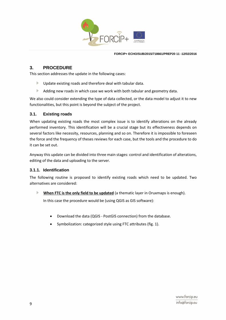
3. PROCEDURE .......................................................................................................... 9
3.1. Existing roads .................................................................................................... 9
3.1.1. Identification ................................................................................................ 9
3.1.2. Editing ....................................................................................................... 14
3.1.3. Uploading .................................................................................................. 15
3.2. New roads ....................................................................................................... 15
3.2.1. Field data collection. .................................................................................. 16
3.2.2. Post-processing ......................................................................................... 16
3.2.3. Uploading .................................................................................................. 20
List of Figures ............................................................................................................. 21
List of Tables ............................................................................................................... 21
REFERENCES ........................................................................................................... 22

FORCIP+ ECHO/SUB/2015/718661/PREP20 11 -12/02/2016
6
EXECUTIVE Summary
The scope of this deliverable is to report about the planned procedures to maintain the accuracy of
the data, assuring its effectiveness in the future. Explanation about procedures to update either
existing roads or the addition of new ones is set out in this document.

FORCIP+ ECHO/SUB/2015/718661/PREP20 11 -12/02/2016
7
1. INTRODUCTION
An update process does not just mean a simple editing of the data. It involves a new survey and the
processing of this new information.
If this task is important in any GIS project, it is even more important when derived products rely on
the accuracy of this data. In a project where the creation of a Navigation system, a road network
study and a public information system, based on the inventory, is planned, a procedure to update
the information must be considered. In this case, data update is required for the maintenance of
the system in the future.
Road network is subject to changes, in forest areas these alterations are not as frequent as in urban
areas, but even in this environment new roads are constructed and some of the existing ones
become inaccessible due to the lack of investment and maintenance in not profitable forests. In
addition, forest disturbances like fires, landslides and/or windstorms can lead to physical changes
in the landscape, including roads. These and other situations must be reflected in the information
stored and the system has to provide the necessary tools to perform it.
In general terms we can consider updating existing roads or just adding new ones (both cases are
an update), but also could be possible to expand the data model, for instance, with new attributes.
In this document we are addressing the first two options, even though the last one could be possible
in the future.

FORCIP+ ECHO/SUB/2015/718661/PREP20 11 -12/02/2016
8
2. MATERIAL
In order to increase the sustainability of the project we consider the same resources (both material
and software) used in the task B (development of the inventory) to elaborate the updating
procedures and tools.
2.1. Hardware
The devices for updating are the tablets used in Task B (see section 3 of FORCIP+ D2.6: Device) and
a desktop computer. It is not necessary to buy new equipment to carry out this stage.
2.2. Software
We will use the same architecture created for the field data collection. The following table shows a
list of software and its main use as a brief summary:
Table 1: software/hardware summary
Software Use Device Available in:
Smap Management of the data collected
Server https://www.smap.com.au/downloads.shtml
geoODK Field data collection Tablet/ Smartphone
http://geoodk.com/downloads.php#
Oruxmaps Spatial positioning Tablet/ Smartphone
http://www.oruxmaps.com/descargas_en.html
QGIS GIS software Computer http://qgis.org/en/site/forusers/download.html
PostGIS Data storage Server http://postgis.net/install/
FORCIP+ ECHO/SUB/2015/718661/PREP20 11 -12/02/2016
9
3. PROCEDURE
This section addresses the update in the following cases:
Update existing roads and therefore deal with tabular data.
Adding new roads in which case we work with both tabular and geometry data.
We also could consider extending the type of data collected, or the data model to adjust it to new
functionalities, but this point is beyond the subject of the project.
3.1. Existing roads
When updating existing roads the most complex issue is to identify alterations on the already
performed inventory. This identification will be a crucial stage but its effectiveness depends on
several factors like necessity, resources, planning and so on. Therefore it is impossible to foreseen
the force and the frequency of theses reviews for each case, but the tools and the procedure to do
it can be set out.
Anyway this update can be divided into three main stages: control and identification of alterations,
editing of the data and uploading to the server.
3.1.1. Identification
The following routine is proposed to identify existing roads which need to be updated. Two
alternatives are considered:
When FTC is the only field to be updated (a thematic layer in Oruxmaps is enough).
In this case the procedure would be (using QGIS as GIS software):
Download the data (QGIS - PostGIS connection) from the database.
Symbolization: categorized style using FTC attributes (fig. 1).

FORCIP+ ECHO/SUB/2015/718661/PREP20 11 -12/02/2016
10
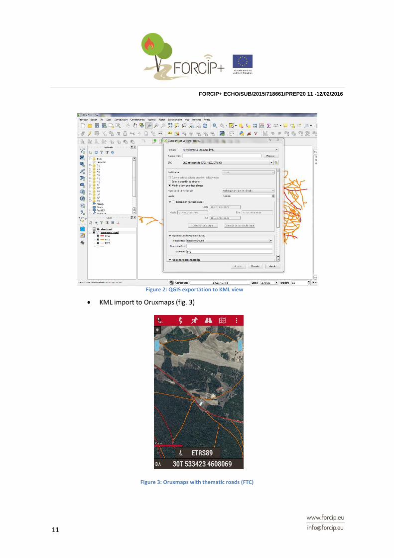
Export to KML (fig. 2) using the parameters as shown:
Format: KML
CRS (EPSG): 4258
Symbology export: enable as Symbol layer symbology
Altitude mode: relativeToGround
Name and description field: No needed.
Figure 1: QGIS symbolization view
FORCIP+ ECHO/SUB/2015/718661/PREP20 11 -12/02/2016
11
KML import to Oruxmaps (fig. 3)
Figure 3: Oruxmaps with thematic roads (FTC)
Figure 2: QGIS exportation to KML view

FORCIP+ ECHO/SUB/2015/718661/PREP20 11 -12/02/2016
12
Identification: using the GPS mode activated and the KML as a thematic layer of FTC it is
possible to spot roads wrongly classified while driving along them in the field.
When all attributes (Tb_Structural) are subject to update.
To access in Oruxmaps to all attributes of each segment:
Display the data in QGIS (fig. 4) (PostGIS connection)
Set the join as shown:
Go to Inventory_road properties – joins menu
Specifications:
Join layer: tb_structural
Join field: id_fr
Target field: id
Export of the result layer to shapefile. CRS unit of this layer must be meter (m) in
order to complete the next point.
Figure 4: QGIS join view

FORCIP+ ECHO/SUB/2015/718661/PREP20 11 -12/02/2016
13
Perform a buffer (fig. 5) using the TB_Width attribute as the buffer distance. A
polygon layer whose width is the attribute in meters and all the info will be
obtained.
Exportation to KML using the parameters as shown:
Format: KML
CRS (EPSG): 4258
Symbology export: it doesn’t work at moment with polygons.
Altitude mode: relativeToGround
NameField: FTC
KML import to Oruxmaps. As a polygon layer, attributes are accessible from the
software, so it is possible to check them. It is also possible to combine the previous
KML layer (lines with symbology) and this one with attributes as shown in the
following figure.
Figure 5: QGIS buffer tool

FORCIP+ ECHO/SUB/2015/718661/PREP20 11 -12/02/2016
14
3.1.2. Editing
The editing in this stage must be carried out in two phases, the first one in the field performed by
the personnel in charge of the task, but subsequently these changes should be verified by
technicians in office:
Customize forms: customized forms were created to carry out the inventory. The same
forms could be used at this point. Anyway, new customized forms can be added to the
device and used for this purpose. The changes will never modify the spatial database; new
object with tables will be created which must be revised before accepting them.
Figure 6: Oruxmaps attributes query

FORCIP+ ECHO/SUB/2015/718661/PREP20 11 -12/02/2016
15
Figure 7 Field data collection quick guide
For the actual field data inventory a guide (fig. 7) was created in which the methodology
using the selected tools is described in detail.
GIS editing: when verification leads to a change in the data, the usage of the editing tools
for tables in QGIS are simple and accessible: field calculator, add or remove field, and so on
are placed in the table when opening. Also, the Table Manager plugin can be helpful when
working with tables.
If any geometry needs to be modified, then the Tool Node provides manipulation
capabilities of feature vertices similar to CAD programs.
3.1.3. Uploading
QGIS connection with the spatial database has been addressed in section 4.1 of the deliverable
FORCIP+ D2.7.
No further actions are required when working directly with PostGis layers, when the editing is saved
the spatial database implements these changes and the update is carried out.
3.2. New roads
The updating of new roads is actually the continuation of the inventory, so the stages to introduce
more data in the spatial database will be the same than in task B. As a summary, a list with different
tasks to be performed in the different stages of the process is presented: field data collection,
editing of the data, and uploading of this data.

FORCIP+ ECHO/SUB/2015/718661/PREP20 11 -12/02/2016
16
3.2.1. Field data collection.
The field data collection procedure was established in the section 4.4 of the deliverable FORCIP+
D2.4. This stage was divided into three steps:
1. Planning and preparation. This step comprises all the processes needed to prepare the
device and the software to collect the data, including cartography input, customized forms
and so on.
2. Actual field data collection. Same as previous point.
3. Post-processing. This point is explained in detail in the next section.
3.2.2. Post-processing
The following steps can be considered as a guide of the post-processing stage, it does not mean
that there are not many ways to get the same result. QGIS software has been used.
Initial data (fig. 8):
Base cartography layer from different sources (see FORCIP+ D2.5)
Segment points/lines (from geoODK) with the road information collected in the field
(including segment code) from customized forms including FTC (firefighting traffic
capacity) attribute.
Tracks from Oruxmaps with the code segment attribute.

FORCIP+ ECHO/SUB/2015/718661/PREP20 11 -12/02/2016
17
Editing:
Line layer (Inventory_road):
Preparation of the base cartography road (Inventory_base): removal of Public Roads (if
included) and elimination of unnecessary attributes.
Addition of the attribute ID to join with the points/lines code segment which contains
the road information.
Segmentation of the Inventory_base layer with (delimitation of segments inventoried).
Editing of the layer when required (new segments or geometry modification using the
tools provided in QGIS):
Segment points/lines (from field data collection)
Oruxmaps tracks as spatial auxiliary reference.
Snapping adjustment:
Settings >> Snapping options >> to vertex and segment.
Tolerance: map units (attention to CRS) or pixels.
Enable snapping on intersections (fig. 9).
Figure 8: initial data in QGIS

FORCIP+ ECHO/SUB/2015/718661/PREP20 11 -12/02/2016
18
Figure 9: snapping options
Assignment of the ID values (fig. 10) to Inventory_base segments according to segment
points/line and tracks.
Figure 10: QGIS editing process
FORCIP+ ECHO/SUB/2015/718661/PREP20 11 -12/02/2016
19
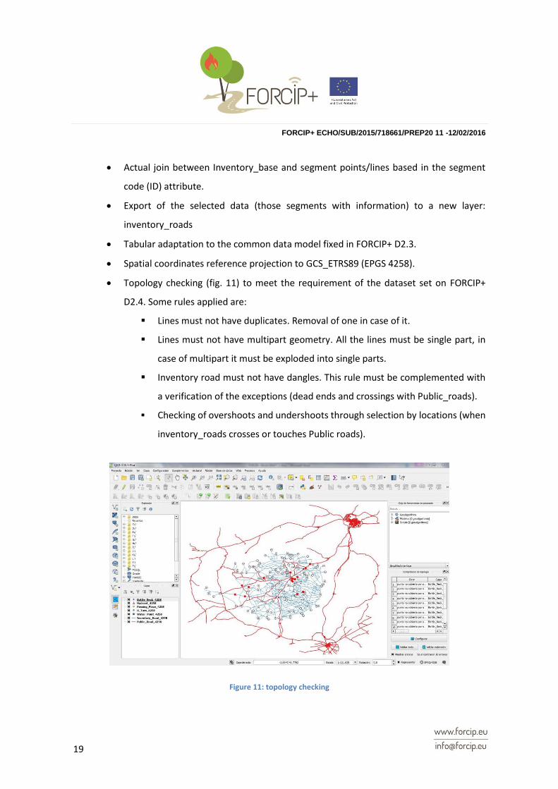
Actual join between Inventory_base and segment points/lines based in the segment
code (ID) attribute.
Export of the selected data (those segments with information) to a new layer:
inventory_roads
Tabular adaptation to the common data model fixed in FORCIP+ D2.3.
Spatial coordinates reference projection to GCS_ETRS89 (EPGS 4258).
Topology checking (fig. 11) to meet the requirement of the dataset set on FORCIP+
D2.4. Some rules applied are:
Lines must not have duplicates. Removal of one in case of it.
Lines must not have multipart geometry. All the lines must be single part, in
case of multipart it must be exploded into single parts.
Inventory road must not have dangles. This rule must be complemented with
a verification of the exceptions (dead ends and crossings with Public_roads).
Checking of overshoots and undershoots through selection by locations (when
inventory_roads crosses or touches Public roads).
Figure 11: topology checking

FORCIP+ ECHO/SUB/2015/718661/PREP20 11 -12/02/2016
20
Point layers (bottle necks, U_Turns, passing places, hydrants and water points):
Tabular adaptation to the common data model fixed in FORCIP+ D2.3.
Topology checking to meet the requirement of the dataset set on FORCIP+ D2.4. Rule
applied are:
Points (bottle necks, passing places and U_Turns) must be covered by lines
(inventory_roads). Spatial editining of the features when necessary: move
spatial feature and snapping adjustment.
Final data:
Line layer (inventory_roads) with the information collected in the field and which
meets the topology requirements.
Point layers (bottle necks, U_Turns, passing places, hydrants and water points) that
complement the information of the road network
3.2.3. Uploading
Once the inventory_road and point layers with the new information have been created and
prepared, only their addition to the PostGIS spatial database remains.
As any other layer the procedure would be as simple as copying / pasting (fig. 12) the selected
features from the new layers to the Inventory_road layer (from PostGIS). Beware of keeping the
same attribute table structure.
Figure 12: copying / pasting operation
FORCIP+ ECHO/SUB/2015/718661/PREP20 11 -12/02/2016
21
List of Figures
Figure 1: QGIS symbolization view ................................................................................. 10
Figure 2: QGIS exportation to KML view ......................................................................... 11
Figure 3: Oruxmaps with thematic roads (FTC) ............................................................... 11
Figure 4: QGIS join view ................................................................................................. 12
Figure 5: QGIS buffer tool ............................................................................................... 13
Figure 6: Oruxmaps attributes query ............................................................................... 14
Figure 7 Field data collection quick guide ........................................................................ 15
Figure 8: initial data in QGIS ........................................................................................... 17
Figure 9: snapping options .............................................................................................. 18
Figure 10: QGIS editing process ..................................................................................... 18
Figure 11: topology checking .......................................................................................... 19
Figure 12: copying / pasting operation............................................................................. 20
List of Tables
Table 1: software/hardware summary ............................................................................... 8

FORCIP+ ECHO/SUB/2015/718661/PREP20 11 -12/02/2016
22
REFERENCES
FORCIP+ D2.3 “Data model schema report”
FORCIP+ D2.4 “Report of the methodology chosen. Ground for and objectives of the proposal”
FORCIP+ D2.5 “A cartographic base. Report of sources used”
FORCIP+ D2.6 “Selection of the solution. Report of device, software and architecture decision”
FORCIP+ D2.7 “Spatial Database with inventoried rural roads”