
D...D D D D T E T T E T T T T T T T E D T LEGEND Planning Area Panaewa (Agricultural) Panaewa...
90
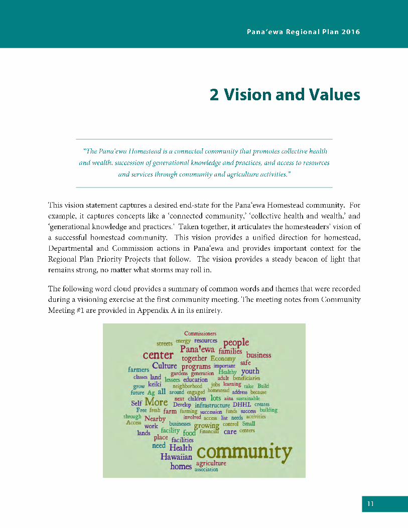
Transcript of D...D D D D T E T T E T T T T T T T E D T LEGEND Planning Area Panaewa (Agricultural) Panaewa...


o
o
o
o

o
o


AU
WA
E R
D
ELA
MA
RD
HO
OLA
ULIM
A R
D
AH
UN
A R
D
E KAHAOPEA ST
OH
UO
HU
ST
POHAI STKA
NO
EL
EH
UA
AV
E
RA
ILR
OA
D A
VE
PIL
IPA
A S
T
E MAMAKI ST
LEILANI S
T
MA
HIA
I ST
MA
KA
AL
A S
T
OPER
ATIO
NS S
T
KUKILA ST
RA
ILR
OA
D A
VE
AU
WA
E R
D
MAHIAI ST
Planning Area
Panaewa (Agricultural)
Panaewa (Residential)
Waiakea
Path
: C:\
Use
rs\r
take
mo
to\D
ocu
men
ts\A
rcG
IS\D
HH
L\H
awai
i\P
roje
ct\P
anae
wa
HH
L C
ensu
s.m
xd
DATE: 8/17/2016
Disclaimer: This graphic has been prepared for general planning purposes only and should not be used for boundary interpretations or other spatial analysis.
Department of Hawaiian Home Lands Island of Hawaii
NorthKau
Puna
North Kona
Hamakua
South HiloNorth Hilo
South Kohala
South Kona
North Kohala
0 3,5001,750
Feet

AU
WA
E R
D
ELA
MA
RD
HO
OLA
ULIM
A R
D
AH
UN
A R
D
E KAHAOPEA ST
OH
UO
HU
ST
PAIPAI ST
POHAI ST
KA
NO
EL
EH
UA
AV
E
RA
ILR
OA
D A
VE
PIL
IPA
A S
TE MAMAKI ST
E PALAI ST
LEILANI S
T
MAMAKI ST
MAHIAI ST
HOOHUA ST
MA
KA
AL
A S
T
HO
LO
MU
A S
T
OPER
ATIO
NS S
TKUKILA ST
AU
WA
E R
D
RA
ILR
OA
D A
VE
Planning Area
DHHL Island Plan DesignationsResidential
Subsistence Agriculture
Supplemental Agriculture
Pastoral
Community Use
Commercial
Industrial
General Agriculture
Special District
Conservation
Path
: C:\
Use
rs\r
take
mo
to\D
ocu
men
ts\A
rcG
IS\D
HH
L\H
awai
i\P
roje
ct\P
anae
wa
Isla
nd
Pla
n.m
xd
DATE: 8/17/2016
Disclaimer: This graphic has been prepared for general planning purposes only and should not be used for boundary interpretations or other spatial analysis.
Department of Hawaiian Home Lands Island of Hawaii
NorthKau
Puna
North Kona
Hamakua
South Hilo
North Hilo
South Kohala
South Kona
North Kohala
0 3,5001,750
Feet
AU
WA
E R
D
ELA
MA
RD
HO
OLA
ULIM
A R
D
AH
UN
A R
D
E KAHAOPEA ST
OH
UO
HU
ST
PAIPAI ST
POHAI ST
KA
NO
EL
EH
UA
AV
E
RA
ILR
OA
D A
VE
PIL
IPA
A S
TE MAMAKI ST
E PALAI ST
LEILANI S
T
MAMAKI ST
MAHIAI ST
HOOHUA ST
MA
KA
AL
A S
T
HO
LO
MU
A S
T
OPER
ATIO
NS S
TKUKILA ST
AU
WA
E R
D
RA
ILR
OA
D A
VE
Planning Area
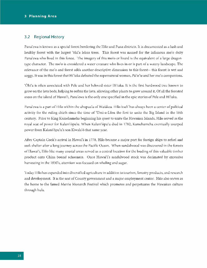
Sub-AreasHomestead & Community Use
Core Commercial-Industrial
Kanoelehua Industrial
Quarry (Yamada)
Outlying unencumbered
Path
: C:\
Use
rs\r
take
mo
to\D
ocu
men
ts\A
rcG
IS\D
HH
L\H
awai
i\P
roje
ct\P
anae
wa
Su
bA
reas
.mxd
DATE: 8/17/2016
Disclaimer: This graphic has been prepared for general planning purposes only and should not be used for boundary interpretations or other spatial analysis.
Department of Hawaiian Home Lands Island of Hawaii
NorthKau
Puna
North Kona
Hamakua
South Hilo
North Hilo
South Kohala
South Kona
North Kohala
0 3,5001,750
Feet


AU
WA
E R
D
RA
ILR
OA
D A
VE
HO
OLA
ULIM
A R
D
E KAHAOPEA ST
AH
UN
A R
D
OH
UO
HU
ST
PAIPAI ST
POHAI ST
KA
NO
EL
EH
UA
AV
E
PIL
IPA
A S
T
E PALAI ST
E MAKAALA ST
LEILANI S
T
HOOHUA ST
MA
KA
AL
A S
T
MANUIA RD
MIK
IOI S
T
HO
LO
MU
A S
T
OPER
ATIO
NS S
T
KUKILA ST
KEONAONA STN
OE
LA
NI L
OO
P
PO
HA
KU
ST
RA
ILR
OA
D A
VE
Planning Area
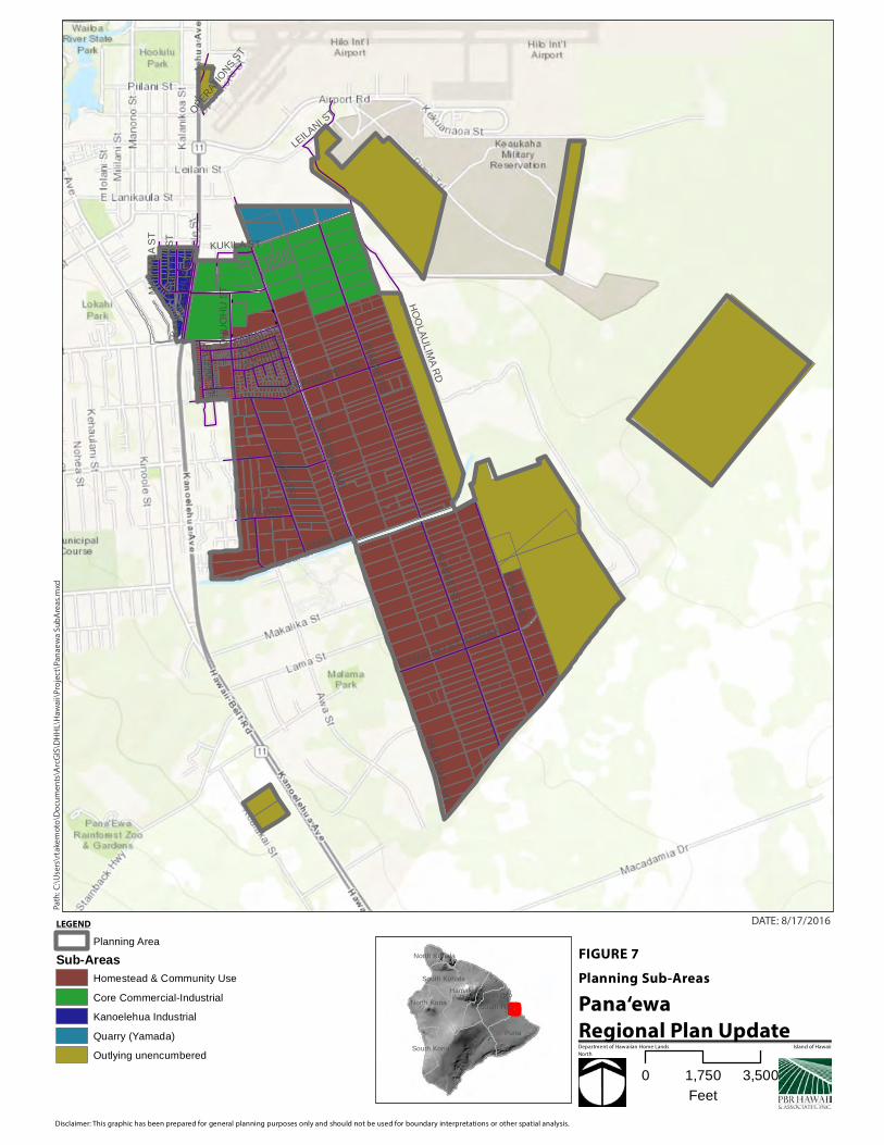
LicensesKamoleao
County
Kuhio Mall Parking
KPFA Right of Entry
General Leases<5 yrs
>5 yrs
Unencumbered Commercial-Industrial Lots
Path
: C:\
Use
rs\r
take
mo
to\D
ocu
men
ts\A
rcG
IS\D
HH
L\H
awai
i\P
roje
ct\P
anae
wa
Lan
d D
isp
osi
tio
ns.
mxd
DATE: 8/17/2016
Disclaimer: This graphic has been prepared for general planning purposes only and should not be used for boundary interpretations or other spatial analysis.
Department of Hawaiian Home Lands Island of Hawaii
North
0 1,500750
Feet

AU
WA
E R
D
ELA
MA
RD
AH
UN
A R
D
E KAHAOPEA ST
HO
OLA
ULIM
A R
D
OH
UO
HU
ST
PAIPAI ST
POHAI ST
RA
ILR
OA
D A
VE
PIL
IPA
A S
T
E MAMAKI ST
E PALAI ST
E MAKAALA ST
MAMAKI STM
AH
IAI S
T
HOOHUA ST
MANUIA RD
KA
NO
EL
EH
UA
AV
E
MIK
IOI S
T
E KAWAILANI ST
KEONAONA ST
NO
ELA
NI L
OO
P
RA
ILR
OA
D A
VE
MAHIAI ST
AU
WA
E R
D
Planning Area
Residential Homestead Lots<10,000 sf
10,001 - 20,000 sf
20,001 - 1ac
Supplemental Ag Lots1.000000 - 2.000000
2.000001 - 3.000000
3.000001 - 5.000000
5.000001 - 10.000000
10.000001 - 12.500000
Path
: C:\
Use
rs\r
take
mo
to\D
ocu
men
ts\A
rcG
IS\D
HH
L\H
awai
i\P
roje
ct\P
anae
wa
Lot
Size
s.m
xd
DATE: 8/17/2016
Disclaimer: This graphic has been prepared for general planning purposes only and should not be used for boundary interpretations or other spatial analysis.
Department of Hawaiian Home Lands Island of Hawaii
North
0 2,0001,000
Feet

AU
WA
E R
D
ELA
MA
RD
HO
OLA
ULIM
A R
D
AH
UN
A R
D
E KAHAOPEA ST
OH
UO
HU
ST
KA
NO
EL
EH
UA
AV
E
RA
ILR
OA
D A
VE
E PUAINAKO ST
PIL
IPA
A S
T
E MAMAKI ST
E PALAI ST
E MAKAALA ST
LEILANI S
T
MAMAKI ST
MA
HIA
I ST
MA
KA
AL
A S
T
MIK
IOI S
T
HO
LO
MU
A S
T
OPERAT
IONS S
T
KUKILA ST
KA
IEIE
PL
RA
ILR
OA
D A
VE
AU
WA
E R
D
MAHIAI ST
Planning Area
State Land Use DistrictsAgricultural
Conservation
Rural
Urban
Path
: C:\
Use
rs\r
take
mo
to\D
ocu
men
ts\A
rcG
IS\D
HH
L\H
awai
i\P
roje
ct\P
anae
wa
SLU
.mxd
DATE: 8/17/2016
Disclaimer: This graphic has been prepared for general planning purposes only and should not be used for boundary interpretations or other spatial analysis.
Department of Hawaiian Home Lands Island of Hawaii
North
0 3,0001,500
Feet

AU
WA
E R
D
ELA
MA
RD
HO
OLA
ULIM
A R
D
AH
UN
A R
D
E KAHAOPEA ST
OH
UO
HU
ST
PAIPAI ST
POHAI ST
KA
NO
EL
EH
UA
AV
E
RA
ILR
OA
D A
VE
PIL
IPA
A S
T
E MAMAKI ST
E PALAI ST
LEILANI S
T
MAMAKI ST
MAHIAI ST
HOOHUA ST
MA
KA
AL
A S
T
HO
LO
MU
A S
T
OPER
ATIO
NS S
T
KUKILA ST
AU
WA
E R
D
RA
ILR
OA
D A
VE
Planning Area
LUPAG(breakwater)
Conservation
Extensive Agriculture
High Density Urban
Industrial
Low Density Urban
Medium Density Urban
Open Area
Important Ag. Lands
(pond)
Resort Node
Rural
Resort
Urban Expansion
University Use
Orchards
Path
: C:\
Use
rs\r
take
mo
to\D
ocu
men
ts\A
rcG
IS\D
HH
L\H
awai
i\P
roje
ct\P
anae
wa
LUPA
G.m
xd
DATE: 8/17/2016
Disclaimer: This graphic has been prepared for general planning purposes only and should not be used for boundary interpretations or other spatial analysis.
Department of Hawaiian Home Lands Island of Hawaii
North
0 3,0001,500
Feet
(road)
A-20a
A-5a
A-20a
ML-20
MG-1a
A-10a
A-10a
A-10a
A-10a
A-10a
A-10a
A-10a
A-10a
MG-1a
A-1a
A-5a
A-5a
A-5a
RS-10
A-10a
A-5a
A-5a
MG-1a
CG-20 ML-20
A-1a
CG-20
A-20a
A-3a
A-3a
OPEN
ML-20
A-5a
RS-15
RS-10
ML-20
RS-15
(road)
OPEN
A-10a
MCX-20
RS-10
MG-1a
A-5aA-5a
RS-10A-10a
ML-20
RS-10
RS-10RS-15
RS-10
RS-10
ML-20
RS-10
OPEN
(road)
RS-10
OPEN
A-5aRS-10
A-20a
OPEN
RS-15
OPEN
CN-10
OPEN
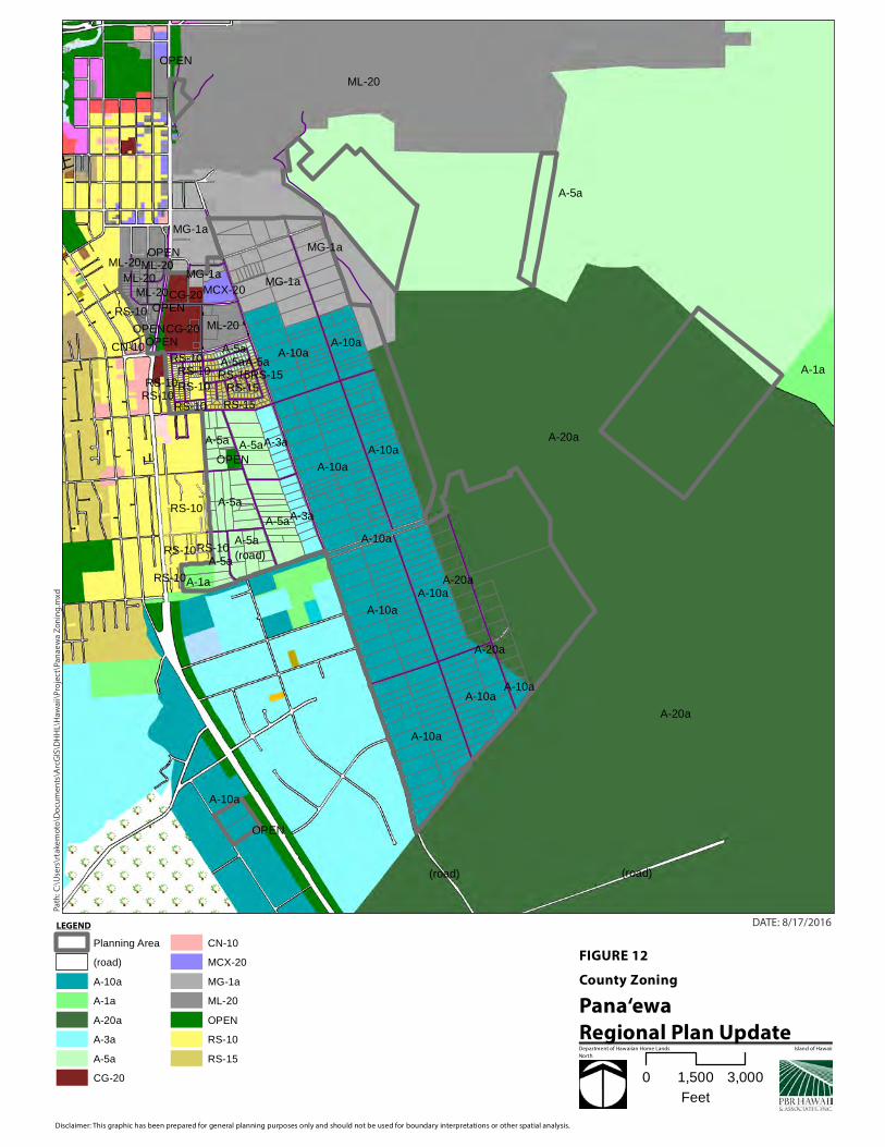
Planning Area
(road)
A-10a
A-1a
A-20a
A-3a
A-5a
CG-20
CN-10
MCX-20
MG-1a
ML-20
OPEN
RS-10
RS-15
Path
: C:\
Use
rs\r
take
mo
to\D
ocu
men
ts\A
rcG
IS\D
HH
L\H
awai
i\P
roje
ct\P
anae
wa
Zo
nin
g.m
xd
DATE: 8/17/2016
Disclaimer: This graphic has been prepared for general planning purposes only and should not be used for boundary interpretations or other spatial analysis.
Department of Hawaiian Home Lands Island of Hawaii
North
0 3,0001,500
Feet
3
3
33
33
3
3
3
3
3
3
3
3 3
33
3
T10
T1
T9
T8
T3
T7
T5T4
T2
T6
Planning Area
MajorOwnerGovt. County of Hawaii
Govt. State
Govt. State DHHL
Govt. State DOT
Kamehameha Schools
Royal Hawaiian Orchards
W.H. Shipman
3 Public Schools
Surrounding Uses
Path
: C:\
Use
rs\r
take
mo
to\D
ocu
men
ts\A
rcG
IS\D
HH
L\H
awai
i\P
roje
ct\P
anae
wa
Su
rro
un
din
g L
and
ow
ner
s &
Use
s.m
xd
PD
F -
Q:\
DATE: 8/17/2016
Disclaimer: This graphic has been prepared for general planning purposes only and should not be used for boundary interpretations or other spatial analysis.
Department of Hawaiian Home Lands Island of Hawaii
North
0 10.5
Miles
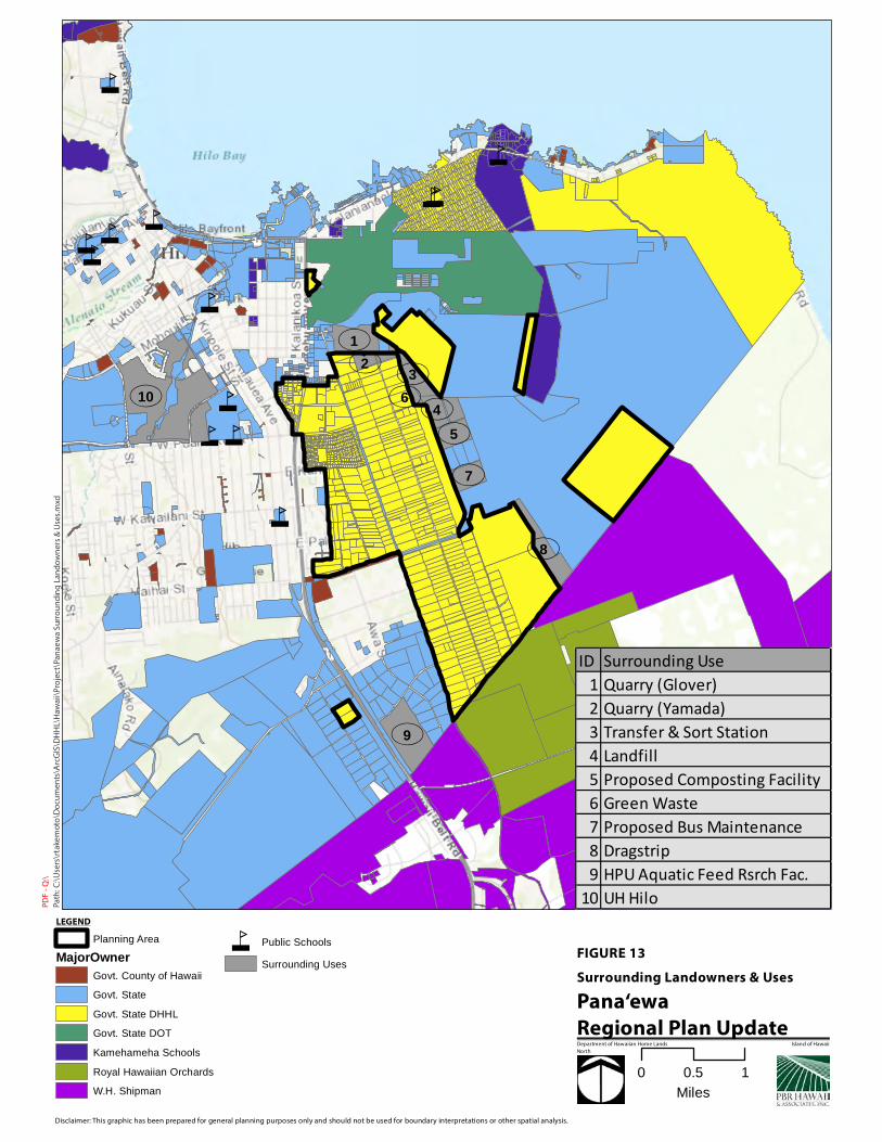
ID Surrounding Use1 Quarry (Glover)2 Quarry (Yamada)3 Transfer & Sort Station4 Landfill5 Proposed Composting Facility6 Green Waste7 Proposed Bus Maintenance8 Dragstrip9 HPU Aquatic Feed Rsrch Fac.
10 UH Hilo


AU
WA
E R
D
ELA
MA
RD
HO
OLA
ULIM
A R
D
AH
UN
A R
D
E KAHAOPEA ST
OH
UO
HU
ST
POHAI STKA
NO
EL
EH
UA
AV
E
RA
ILR
OA
D A
VE
PIL
IPA
A S
T
E MAMAKI ST
E PALAI ST
LEILANI S
T
MAHIAI ST
MA
KA
AL
A S
T
OPER
ATIO
NS S
T
KUKILA ST
AU
WA
E R
D
RA
ILR
OA
D A
VE
Planning Area
County Sewer Mains
County Water Lines
DHHL Island Plan DesignationsResidential
Subsistence Agriculture
Supplemental Agriculture
Pastoral
Community Use
Commercial
Industrial
General Agriculture
Special District
Conservation
Path
: C:\
Use
rs\r
take
mo
to\D
ocu
men
ts\A
rcG
IS\D
HH
L\H
awai
i\P
roje
ct\P
anae
wa
Wat
er &
Se
wer
.mxd
DATE: 8/17/2016
Disclaimer: This graphic has been prepared for general planning purposes only and should not be used for boundary interpretations or other spatial analysis.
Department of Hawaiian Home Lands Island of Hawaii
North
0 3,0001,500
Feet

(mid-level roadway)
(Kupulau Rd. extension - south)
(Kupulau Street extension - north)
(Malaai Road extension)(Keaau Rd. access)
(Iwipolena Road extension)
(Komohana Street extension)
£¤11£¤2000
£¤19
£¤130
£¤139
£¤1970£¤1370
Ain
aola
Dr
Kin
oole S
t
Kila
ue
a A
ve
Railro
ad A
ve
Kaiwiki Rd
Haihai St
Amauulu Rd
Aw
a S
t
Kukua
u St
Kawailani St
Kom
oh
an
a S
t
Mohouli St
Ako
lea R
d
Kalanianaole St
Landfill R
d
Hoaka Rd
Waianuenue Ave; K
aumana Dr
Ainala
ko R
d
Auw
ae R
dLeilani St
Pal
aai S
t
Alu
St
Sta
inba
ck H
wy
Ahuna R
d
Kapio
lani S
t
Kea
laka
i St
Kapili Ave
Todd Ave
Kula
na S
t
Wailuku Dr
Ala
loa
Rd
Kula
loa R
d
Alawaena Rd
Desha Ave
E Kahaopea St
Old
Vol
cano
Rd
Aka
la R
d
Piilani St
Ma
hia
i St
Oih
ana
St
Kipimana St
Chong S
t
Uluwai St
Waik
ahe
Rd
Lyman Ave
Banyan D
r
Ela
ma R
d
Ma
ka
ala
St
Kuaaina Rd
Edita S
t
Kipa St
Kuawa St
Puku S
t
Ma
ikai S
t
Ma
la'e
Pl
Kap
aka S
t
Aw
apu
hi S
t
Ho'ohua St
Ainakahele St
Aup
un
i St
Auw
ae R
d
Kap
iolan
i St
Planning Area
Proposed GP Roads Amendment
Proposed GP Collector Roads
State Highways
County Roads
Other unimproved roads
Residential_Homestead_Lots<0.5 acre
Supplemental Ag Lots1.000000 - 3.000000
3.000001 - 5.000000
5.000001 - 10.000000
10.000001 - 12.500000
Path
: C:\
Use
rs\r
take
mo
to\D
ocu
men
ts\A
rcG
IS\D
HH
L\H
awai
i\P
roje
ct\P
anae
wa
Ro
ads.
mxd
PD
F -
Q:\
DATE: 8/17/2016
Disclaimer: This graphic has been prepared for general planning purposes only and should not be used for boundary interpretations or other spatial analysis.
Department of Hawaiian Home Lands Island of Hawaii
North
0 10.5
Miles
Delete connection to Railroad Ave


Appendix A Community Meeting #1 – Beneficiary Consultation Meeting Notes

PANA‘EWA REGIONAL PLAN—MEETING #1
GROUP DISCUSSION NOTES – Group 1
Pana‘ewa Park
March 8, 2016
6:00 pm – 8:00 pm
Vision of Success
Culture
Culture brings people together by participating in shared positive activities. The culture of this place
should be perpetuated for future generations.
Regular celebrations of National Holidays by the community: Lā Ku‘oko‘a, Lā Ho‘iho‘i Ea
Informed, engaged, and participating community
People helping people
Safe place
Membership Participation in Association
Some worthwhile project to benefit community
Stakeholder and community leaders actively involved in the community and involved with
decision makers in coordination with DHHL
Community that acknowledges its past (history) and proud of its future—the youth
A community with an active credible association leadership to address the needs of the
community
Members are volunteering to be on committees to better community or keep community
engaged with each other and government
Culturally vibrant in address concern
Culture – building unity, perpetuating culture
I believe Panaewa is getting there. We have a neighborhood watch. We want to work toward
Kamoleau and gardens for families that want to grow their own veg
What you folks doing tonight is long coming. I wish this was done long time ago. But never the
less, it going to happen. I’m glad working together
Hawaiian culture alive and well – Hula – Art – Olelo Hawaii – Singing – Protocol
Athletic Competitions between homesteads
Agriculture (also incorporated into Culture)
Investing in local agriculture creates a self‐sustaining community. The majority of our food is imported
and not fresh. We need more fresh produce instead of poisoning our people with processed food. An Ag
Hub to sell local produce provides a platform for more people to grow food and support their ohana.
People can make money off their lots by investing in commercially viable agriculture. While startups are
difficult, self‐help programs pool together resources for community members to share the use of
expensive equipment (i.e. bulldozers) to prep land and farm. All the while, our youth are observing this

2016 Pana‘ewa Regional Plan Update March 8, 2016 Meeting #1, Group #1 Notes
Page 2
collective approach to agriculture and self‐reliance whereby it becomes second nature and they are
inspired to perpetuate the work of their predecessors and community.
Productive/vibrant farm lands
Community gardens (residential lots) provide fresh food for all/most lessees
More resources for the farmers – les traffic
Lessees using the ag lands for what it was intended
Farmers will be successful (plants, etc. growing with workers on hand)
Families will be lending helping hands to each other to make farms and businesses prosper
Graduates going off to college
Lots of gardens
Community imu
Being self sustainable e.g. agriculture income
Teach community to be self sustaining by growing own vegetables: 1) soil process; 2)
hydroponics
Solar grid for Ag – self sustain – less expensive – organic
Self‐help – getting people back on the land
Youth
The youth are the future of our community. If there’s nothing here for them they will leave. They need a
means to stay. The data shows that there are no transitional programs for youth during afterschool,
breaks, etc. There is an opportunity and need to develop a safe place for keiki during these transitional
times. Programs could be developed and centered around growing farmers, growing keiki on aina. This
creates the message for youth that “farming is sexy”.
Variety of youth programs specific for Pana’ewa keiki – education/academic – sports
Services/Amenities
Nearby school facility
Health and wellness culture center
Nearby fire department
Nearby police department
Nearby medical facility
Build bowling alley
Washerette
Commercial eateries
Health facility
Safe housing
o Evict drug house
o Assist to fix up old housing
o Sidewalks
o Childcare/preschool with adult care combo
o Self help shed for farmers with tools, large equipment, poison

2016 Pana‘ewa Regional Plan Update March 8, 2016 Meeting #1, Group #1 Notes
Page 3
Economy
Self sufficient in terms of $
Education on business and financial success
Economic guidance and well being for all businesses and ohana
More funds for homes, farmers market, small business
Nearby shopping
Maximize land use for future gain
Healthy and thriving families with job opportunities
Business incubator to help native Hawaiian business start ups
Access to existing funds – Nelson Case
Infrastructure
Community facilities provide a safe place for keiki to grow, learn, farm. Infrastructure and facilities built
together by neighbors and beneficiaries galvanizes the community. Energy facilities such as micro‐grids
feed into homestead lots and relieves lessees of energy expenses which can go toward more important
resources.
Renewable energy for all lessees (reduced dependence on HELCO)
Updated and improved infrastructure for a safe community
Sustainable, thriving community with various resources easily accessible to the residents
Protection/Perpetuation
Develop homes to get more people on the land. People are dying on the list. Award lands with or
without infrastructure.
More leases/homes for Hawaiians
Develop lands to build more homes for those on the waiting list
Farm lots – those who are not using their lots should be terminated so those on the waiting list
can get a farmlot – this was done in 1986 when I got mine
Stop all Hawaiian names “Eviction” – DHHL work with families
More Hawaiians “on” the aina
Lowering blood quantum

2016 Pana‘ewa Regional Plan Update March 8, 2016 Meeting #1, Group #1 Notes
Page 4
Issues & Opportunities
Resources/Financing
$$
Grants are out there
Lack of support and resources to accomplish the community’s need
Provide community heavy equipment
Kanaka on the aina
Release the money from “Nelson Case”
Water Rights
Provide affordable financing
Issue: little to no financial support (or advertisement of) for farmers
DHHL should help us succeed!! Rather than threaten eviction
Resolution on Nelson case
Reserve/separate income from general leases for Panaewa
o What is the leave rent monies
o Accounting for lease money to know how much
o Beneficiaries direct where money goes
Subdivide lands
Partnerships/Governance
Partnerships with those who have large commercial properties leases
Law makers need to be present at one community meeting. No one is here tonight.
Issues: Na‘i Aupuni Fed rec rules over DHHL lands
Housing Options
More people on the land
No housing contracts for land
Opportunity: Immediately award lands to kanaka willing to accept no infrastructure
Lessees renting their homes in Panaewa and Keaukaha to outsiders not Hawaiians
Fee simple loans
Home options 1 bedroom/3 bedroom
Assistance in homeownership
Private funding
Issues: first priority get people on the waiting list a home or land; use $13 million lease rental
income to fund this
Build affordable homes
Restart self help building homes
Use habitat for humanity
Kupuna housing
Issue: Reduce home sizes or loan amounts for elderly on the list

2016 Pana‘ewa Regional Plan Update March 8, 2016 Meeting #1, Group #1 Notes
Page 5
Provide senior housing
Allot funds for house repairs for those need in form of grants especially kupunas or older
residential lots
Sense of Community
Opportunity: Sufficient open lots in various “zones” – promote native Hawaiian business and
increase beneficiaries on aina
Farmers come together to help develop each other’s properties – sense of community
Too much infighting
Lack vision; unable to move ahead
Opportunity: close proximity to town. Ease to outreach to people from outside community.
Develop more revenues for community
Poor leadership; and people (good people) are unwilling to get involved.
Programs
Housing assistance
o Identify/increase options
o Move‐in ready/affordability
Financial literacy
Holistic programs
Capitalize on skill‐set of community
Farming/Ag training
Entrepreneurial classes
CRN Nursing classes
Provide training workshops
Our youth will be more Akamai by participating in community activities whether it’s farming – or
helping to direct groups in different activities
Infrastructure
Fill gap areas: cheaper ag water rates and water (free water); install photovoltaic on roofs
(leasing) cheaper energy
Provide neighborhood transportation
Waitlist
Plans derived for Makuu farmers – but they refused to move – funds already expanded for
development should be continued for homes for those on waiting list
Opportunity: build homes for waitlist people using lands earmarked for Makuu
Help to create homesteads on our other trust lands – Piihonua – Lifting moratorium on
agriculture was to help lessees provide for land for their ohana.
Stop lessees from selling vacant lands…no conditions

2016 Pana‘ewa Regional Plan Update March 8, 2016 Meeting #1, Group #1 Notes
Page 6
Who should we contact? Who should participate?
Hawaii Community College in collaboration with Alu Like (for training programs)
Waitlist/applicants
DHHL Leadership
Farmers
Residential
Construction companies (for pro bono work)
Kamehameha Schools (develop programs; help with developing facilities)
o East Hawaii Regional Team
o Community Education Division
DHHL has to be more involved after the planning phase and truly support beneficiaries

Appendix B Community Meeting #2 – Beneficiary Consultation Meeting Notes

PANA‘EWA REGIONAL PLAN -- MEETING #2
MEETING NOTES
Waiäkea Elementary School
April 30, 2016
9:00 am – 3:00 pm
Questions/Comments from meeting participants on Introductory Presentation (see Power Point):
I don’t see discussion on 1/32 succession that we mentioned last meeting as part of vision
Where in this are we going to be able to address the land use issues in our community? Is that on the agenda today, not only talk about projects
Can we develop a consultation policy for land use amendments specific to Pana’ewa and put into regional plan? Will Hawaiian Homes Commission (HHC) and DHHL honor that?
Is every single ag lot occupied by lessee?
Can you clarify, is the whole yellow box for KPCA? Farmers market is only 1 acre
but want to expand to 5 acres
Presentation by Pana’ewa HHLCA
In 1993, establish as a multi-million dollar corporation
1995 – Hāola Inc. – did study to determine what programs were wanted in
community; did vital statistics study: avg amount of $ income; who lives in home;
demographics of our community
Started with playground, then enclosed the open pavilion,
Summer programs, hula, etc. the park wasn’t enough room – so we developed
Kamoleao Plan
We used to use forest area before it became a parking lot; that was the last
lowland lama/Hala forest intact; community was torn by that; went after land at
Kamoleao to protect rest of forest
Rehabilitation Act – when you are looking at developing land – homestead
(farming per Webster)
We went after Waiākea Center money in lease agreement - $ directly to
community - $100K annually; we didn’t want the money originally but wanted
them to build us the community center
Kamoleao was named by Pua Kanaka‘ole

2 Pana‘ewa Regional Plan Update Meeting #2
Wanted a stone wall around entire area – wanted a Pu‘uhonua; created a Wahi
pana
The community center was the forest first – not the building
Kamoleao is surrounded by commercial, AG, and residential – how do we
heal/rehabilitate with buildings?
Did recent survey – strong support for health care facility – 3,000sqft
concentrated facility;
It's gotta be self-sustainable; can't live on grant alone; needs a return to manage
the facility
Keaukaha - Pana‘ewa Farmers Alliance
280 leases on 1600 acres of land at lots
Have a ROE for land – what we have is an education center where UH professor
– Dr. Sakai is giving classes – open to community and public (want to expand to
organic hydroponic system)
Have a water meter now – hoping to submit a plan to open up more of the land;
offices; open for farmers to utilize
Here’s our issue – doing a survey for all of our farmers so we can better identify
the needs for them
We need help with association and our board – if you are an AG lessee please
get involved
Participants then broke-out into two groups. Each group had the opportunity to talk
about two topics: Community Facilities and Agriculture Programs. Participants
suggested possible projects and programs related to the two topics.
DISCUSSSION ON COMMUNITY FACILITIES
Group 1:
We should have a small facility / pavilion to sell concessions at the community
park
Health Center
o Services need to be affordable to people with limited income
o The location of a health center needs to be near küpuna. Existing health
facilities are too far for küpuna.
o The plan 20 years ago – was a one-stop shop, center, küpuna housing;
health care is #1; can still do cultural practices near health care facility;
The current plan for Kamoleao is a multi-purpose, kitchen and office – still in
planning on 1.5 acres. The previous plan was too big; hard to implement.
Taking it in phases – fulfill dreams now.
3 Pana‘ewa Regional Plan Update Meeting #2
The multi-purpose building can be used as a venue for graduation parties,
weddings, gathering and convening’s; 500 person occupancy.
Big opportunity to partner with Hui Mälama Na Ola Oiwi; several of its board
members are Pana‘ewa homesteaders.
Hui Mälama provides health education, nurse training, outreach services and
community events. Provides diabetes, cancer, hypertension, covers the whole
island.
Hui Mälama is on Railroad Avenue now, but moving to Kilauea; it is looking for a
permanent site.
Hui Mälama does not service only Native Hawaiians because of the grant money
it receives, but if its located in a Hawaiian community, a higher percentage of its
clients should be Hawaiian.
One-stop institution in Pana‘ewa, OHA, Alu Like, KS, QLCC. Need office space.
Need infrastructure – need sewer line at Kamoleao (stub-out Home Depot) [site
at Kamoleao]
Preschool / after school programs / tutoring / educational programs.
Provide meals for community – keiki and küpuna; healthy meals.
Cultural programs; language; knowledge of land base at Pana‘ewa; know that
place.
Provide agricultural and animal husbandry.
Location-near residential / Kamoleao is ideal.
Native forest – if there is something there, identify where / what to save. Need to
have some open space / integrate need some green.
Take out commercial development out of future land use.
Look at what is going around on neighboring land and look for opportunities to
partner.
No Railroad Avenue connection to Pana‘ewa.
Integrate complete streets into the design of the community. Needs to be more
walkable and safer for pedestrians.
Group 2:
Elderly housing was planned to be across the street from Kamoleao. Maybe site
housing in strip on the residential side versus at Kamoleao; not at park because
it is congested;

4 Pana‘ewa Regional Plan Update Meeting #2
Elderly “playground” – facility to help küpuna exercise and stay active – there are
existing models.
Site elderly playground closer to Ohuohu Street – linkage to residential lots to
facility in safe reasonable level – “complete streets.”
Build a pedestrian bridge.
Küpuna housing – near farmers’ market?
Turn Pana‘ewa Park into Küpuna Housing and then Park uses Kamoleao.
We need a cemetery to keep our loved ones nearby.
Lease space in commercial industrial to farmers and new entrepreneurs and
small businesses. Keep the rent affordable.
Partner / leverage surrounding uses and activities to help community.
Access to green waste mulching.
Health services (all) küpuna care and community clinic in one facility.
Possible partner – Hui Mälama at Kamoleao.
Health Education / Prevention
Education – history of Hawaiian Home Lands (classroom).
Multi-media center – campus/ access/ video conferencing so DHHL doesn’t have
to fly us in all of the time.
Maintenance is expensive – need to generate money to pay for the operation of
the facility. It doesn’t matter what is on the land (Kamoleao, it needs to be
economically self-sustaining).
Every general lease needs to have a community benefits agreement in it. The
community needs to get something in return. It does not have to be in the form
of money. The developer could build and construct the facility for us. That was
the original desire of the community during the Prince Kuhio Mall construction.
The developer was going to plan and design Kamoleao for us. But DHHL did not
select that developer and the new developer that DHHL did select only agreed to
pay the community money in annual installments. That is where we are now.
Kamoleao is a prime area and location. Consider a mixed use facility. For
instance, bottom floor could be a community center and the second floor could
be medical offices.
Every time the lease comes up for negotiation, require a CBA and money to
community.
There were lease provisions that required the Kuhio Mall lessee to provide
training and employment opportunities for Hawaiians. Those provisions haven’t
been enforced. We need to enforce those provisions.
5 Pana‘ewa Regional Plan Update Meeting #2
Expand the bus service to go into the homestead area so people do not have to
walk to the mall to catch the bus.
Flooding at Puainako and Kanoelehua is a safety issue.
No Railroad Avenue Extension.
No Leilani Road to Airport extension.
One stop shop for Native Hawaiian services at Kamoleao.
La‘au lapa‘au garden.
DISCUSSION ON AGRICULTURE PROGRAMS
Group 1
Subsistence Ag lot size o Different for all islands
o Makuu Relocation is a good example of “right” size for Hawaii Island: 2 ½ acres
Provide definition of subsistence agriculture
Residential parcel (in yellow) – provide sound mitigation to protect future homes (i.e. walls)
Barriers to successful agriculture o Lack of loan programs
o High start-up costs o Limited access to water o Land prep – high cost
Help expedite farm start-ups
If have funding/loans for agriculture, who is responsible to communicate to ag lessees?
Agronomics H20 o Good program, how do they get to know about it?
Ag and pastoral lots will have failure – so have to stop this – get educated
There was another program for people that were declined on their loan application. Where’s this program now?
Vacant lots in residential
Who farmers need to see for ag resource programs?
The disadvantage of doing agriculture in Pana‘ewa is the cost of water – 45 cents o No breaks for farmers, but sources are on DHHL lands
Agriculture is not the problem; residential use is not the problem o 18 year old + 30 year old + 50 years going down
A barrier to farming (successful ag homesteading) is enforcement—there’s no consequence to breaking the ‘rule’ of having to farm.
Ask successful farmers how they did it? What was their motivation to farm? How did they remain focused over time?
6 Pana‘ewa Regional Plan Update Meeting #2
2 phases – help existing farmers and put more people on land
DHHL support existing program
Right of Entry
30 years didn’t farm – USDA not going give you loan
DHHL get surplus equipment o Bulldozers
For Pana‘ewa, subsistence agriculture should be 2.5 acres. Anything less than that should be called residential.
Group 2
Promote self-sustaining families first o Enough land to farm for entire family
o If excess, then provide food for community, then larger region
Preserve forest vs. farming
Marijuana opportunity
Diversified Agriculture
Food sovereignty
Backyard gardening o Supplement meals = save money
Specialization among neighbors o Rotation between each resident
o Sharing produce
Farm loan – make available
CTAHR Programs
Dept. look for additional funding to move agriculture forward o From both Federal and State
Lä‘au Lapa‘au gardens o Puainako strip?
Hui Mälama O Na ‘Öiwi program
Specialization among farmers o Bring product to farmers market o Need more vendors to be successful; at least 30
Learning Center o Different cropping systems o Teach future generation
Processing plant o Value-added goods
Hydroponics o Soil-less, easiest, cheapest
Ag water o DHHL providing proper infrastructure o Should be free for farming
o Rain catchment – sometimes denied by County o Well water – there’s lots of wells in Pana‘ewa, can we have access to that
water?

7 Pana‘ewa Regional Plan Update Meeting #2
1”-meters for ag lots o Increase meter size o DHHL buy meters
Pana‘ewa should be a pilot project to push free water system
Exchange of products for farmers o Mulching, soil o Working group to start conversation o Seek grant to support effort
Not enough rain water anymore
Water catchment on Ahuna Road o Denied by County because within County limits
DOE school lunch o We don’t have the product
Subdivision of ag lots?
Land use designation policy
Opposed to residential designation
Check vacant lots first
Bad planning to mix residential and ag
Concerned about density
Continue existing programs
The following map and related notes, illustrates the physical location of where
participants would like to see changes in their community.

Appendix C Project Matrix
9 Pana‘ewa Regional Plan Update Meeting #2
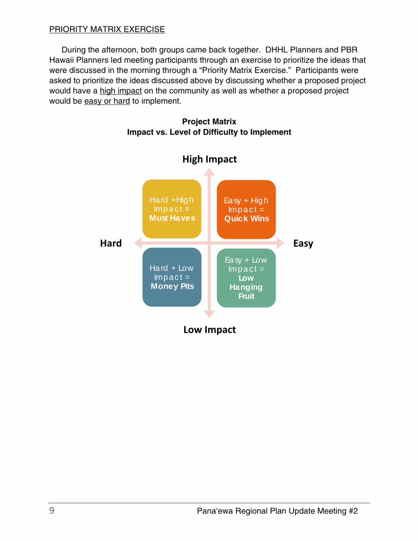
PRIORITY MATRIX EXERCISE
During the afternoon, both groups came back together. DHHL Planners and PBR
Hawaii Planners led meeting participants through an exercise to prioritize the ideas that
were discussed in the morning through a “Priority Matrix Exercise.” Participants were
asked to prioritize the ideas discussed above by discussing whether a proposed project
would have a high impact on the community as well as whether a proposed project
would be easy or hard to implement.
Project Matrix
Impact vs. Level of Difficulty to Implement
High Impact
Hard Easy
Low Impact
Easy + High Impact =
Quick Wins
Hard +High Impact =
Must Haves
Easy + Low Impact =
Low Hanging
Fruit
Hard + Low Impact =
Money Pits

10 Pana‘ewa Regional Plan Update Meeting #2
The hand written notes in the photo above were transcribed in the notes below.
EASY / HIGH IMPACT
• Open/Natural space at Kamoleao
• Green waste mulching (access to)
• Health education and outreach for prevention
• Expand bus service
• Training and employment
Facility
Enforce General Lease
• Elderly “Playground” (check realtors program)
• Preschool and after school program
• Cultural programs and history of Panaewa
• Stop PMAR/Leilani connection to Railroad (advocate to County)
• Land use amendment beneficiary consultation process for Panaewa

11 Pana‘ewa Regional Plan Update Meeting #2
• Multi-purpose center as proposed in EA (Add innovation renewable energy
component for findings)
• Community garden (along Puainako) La‘au Lapa‘au
• Complete/safe streets – bus routes (Puainako – State highway tap State
complete street fund)
• Multi-purpose facility and kitchen with mult-media
• Expand existing programs
• Establish program to market ag/value-added products
• KPFA lot ROW to permanent license (1 acre to 10 acres)
• Farmer training programs
• Animal husbandry
• Hydroponics
• Shared gardening
Training
Trade
Strengthen relationships
HARD / HIGH IMPACT
• Sewer connection to Kamoleao
• Meals to keiki to küpuna (certified kitchen)
• Mixed community use and commercial
• Exchange lands – outlying lands
• Senior housing (location?)
• Park – Kamoleao
• One-stop Hawaiian agencies
• Hawaiian agency one-stop
• Future development areas – partner infrastructure
• Target and expedite start-up funding programs
• Commercial /industrial incubator small business (Affordable)
• Health center /medical clinic (partner with Hui Mälama)
• DHHL assert right to free ag water
• Ag lease enforcement
• Increase water meter size (currently ag lots is 1”)
• Farm-to-school
• Ag processing plant for value added products
• Community ag facility with access to shared equipment
HARD / LOW IMPACT
• Small concession facility at the community park (Panaewa Park)
• Community garden in “subsistence ag” buffer
• Cemetery
EASY / LOW IMPACT
[NONE]

12 Pana‘ewa Regional Plan Update Meeting #2
OTHER ISSUES
At the end of the meeting, participants were asked if there were any other issue
that they would like to discuss that was not discussed previously in the meeting. The
following is a list of other issues that participants identified.
• DHHL needs to answer phones or return calls in a timely manner.
• Any new places that DHHL develops, make sure that the new use is consistent
and compatible with surrounding uses. New homesteads should not be restrictive and
have DCC&R’s.
• How do we get more people to participate in meetings?
• Meeting should be in community in which the subject matter is being discussed.
• Meeting farm plan and financial requirements are hard.
• Don’t open up Railroad Avenue and Leilani Rd to Airport to the public. But keep
Leilani Road open as an emergency access route for Keaukaha only).
• Definition of sub-ag lots needs to be completed in rule before implementing sub-
ag lots.
• In the Hawaii Island Plan, change the yellow area delineated for homesteading in
Panaewa to agriculture.
• The agriculture program was supposed to be subsistence focused first. Any crop
production in excess of what a family needs should go to the community. A farm plan
should not require the farmer to generate an income.
• Existing larger lot sizes should have the opportunity to be [grandfathered into] the
subsistence agriculture program. Families should have the opportunity to subdivide a
larger lot so that their children can live by each other over time and don’t have to move
away.
• Allow accessory dwelling units.
• In divorce, a lessee and their ex-spouse may have to sell the lot in order to
equitably divide their assets between each other.
• Subsistence rules – each island/place should have unique lot sizes, be flexible.
• Allow medical marijuana as a crop on homestead land?

Appendix D Community Meeting #3 – Beneficiary Consultation Meeting Notes
DHHL PANAEWA REGIONAL PLAN ‐‐ MEETING #3 MEETING NOTES Panaewa Park
Wednesday September 14, 2016 6:00 pm – 8:00 pm
Plan should suggest ag‐loan programs to expand operations.
DHHL should make lessees more aware of resources that are out there.
Plan not just for the 1‐acre KPFA lot, but for the larger area.
Look at state and federal funding opportunities for agriculture.
Vote on entire regional plan, not just priority projects.
Figure 19 – concerned that DHHL will redistribute all the land. o Propose deleting / more discussion needed; o If leased lots, DHHL needs to discuss and vet with lessees;
County vs. DHHL land use. Comments on Kamoleao
Connectivity from Railroad Avenue to projects; Puna (related to multiple priority projects).
Simplify (Kamoleao) to start with a smaller portion; one facility and infrastructure; the rest will follow.
PHHLCA has completed design plans for a phase 1 community center and certified kitchen.
DHHL will advocate that the County delete the Puna By‐Pass Railroad Avenue connection as an option from the County General Plan. DHHL will put this recommendation into the executive summary of the Updated Panaewa Regional Plan.
Comments on DHHL Hawaii Island Plan Update Priority Project
What is this map showing (Figure 19)? I am concerned about the recommendations in this map. It hasn’t been vetted by the community.
DHHL: To implement Figure 19, requires an Island Plan amendment. But based on previous comment, Figure 19 will be deleted.
DHHL: Updating the Island Plan allows both DHHL and beneficiaries to take a comprehensive look at DHHL’s land use designations. The plan was adopted in 2002 so 14 years have passed. Because of that, some of the recommended land use designations in the existing Hawaii Island Plan need to be re‐evaluated.
DHHL: The Hawaiian Homes Commission approved the administrative rule for DHHL subsistence agriculture program to be transmitted the Governor’s Office. Once the Governor’s Office reviews and ‘ok’s’ the draft rule, the draft rule will go out for public hearing. The current draft rules that the HHC approved to be transmitted to the

Governor’s Office incorporated feedback received from beneficiary consultation held in the fall of 2015. It is recommending that the minimum lot size for subsistence agriculture range from half acre to 3 acres.
A half‐acre lot is not agricultural, it’s residential. I am very upset that we will not be given a chance to opine that a half‐acre lot is not appropriate for Panaewa.
DHHL: Updating the Hawaii Island Plan will be an opportunity for beneficiaries and existing lessees in Panaewa to define what they think the appropriate minimum lot size for agriculture homesteads should be.
DHHL needs to avoid referring to subsistence agriculture as a half‐acre size lot because the administrative rules have not been approved.
We should change the title of this priority project to “Involve DHHL beneficiaries in the Update of the Hawaii Island Plan for East Hawaii.”
Area near proposed farmers’ market zoned residential.
Island Plan ‐‐ leases are ending and land is opening up. This should be considered in the Island Plan.
Commercial leases across the highway should be a part of the Panaewa Regional Plan analysis.
Engage the Panaewa Community in land use designations o Thresholds for land use (i.e. adequate water) o Designation prescriptives (i.e. subsistence agriculture should be 3‐5 acres)
DHHL: In the priority project write‐up for Hawaii Island Plan update, we will outline in more detail the process and analysis that is involved in developing an Island Plan.
Beneficiaries should be notified about administrative rule making, EA’s and EIS’s. DHHL shouldn’t respond to request for comments on EA’s and EIS’s without consulting with communities that may be impacted by these projects.
Plan needs to be answerable to community. Panaewa Park / Family Center Management
Need transparency – today!
Community association should have a say.
DHHL should be present at license renewal discussions with the County and PHHLCA. Ag Training Center
38 respondents to survey – representative of larger group of farmers. Survey indicated that they need a processing plant, but if farmers are not ready then they don’t need.
Focus on one facility at a time.
The Panaewa Regional Plan should incorporate the new KPFA plan to be presented at CBA meeting. The plan focuses on addressing the needs of the 38 respondents.

USDA CF Funds – No brokerage education discussed. o i.e. get marketing / wholesale training o possible long‐term initiative
Other Issues
At the end of Railroad Avenue, there is illegal dumping, car racing, gun shots, loitering, cars end up in lessees yard. Vandalism of mailboxes.
These activities are being carried out by others and not Panaewa residents.
Lessees have called the police department about these issues many times, but the police do not respond.
Possible priority project is to install a gate to prevent these activities and speed humps and signage along Railroad Avenue.
The same situation occurs on Auwae Road. All lessees signed a petition to install speed humps except for one lessee.
DHHL: Perhaps a new priority project should be inclusive of all traffic related issues near the agriculture lots on Auwae Road and Railroad Avenue.
Monitor development of farm areas and uses, especially those with piggeries that produce noxious smells. Maintain farms so that it is not a nuissance.
Next Steps
DHHL was planning to take the Panaewa Regional Plan to the Hawaiian Homes Commission for adoption in October when the Commission meets in Hilo.
However, based on the comments and sentiments heard tonight, the plan is not ready for Commission approval and needs substantive revisions to several sections.
DHHL will revise the plan based on the comments heard tonight and have another meeting with the community so that the community will have an opportunity to review the revised plan.
The next meeting will probably be in November.

![Sport is fun!. [ǽ] [ǽ] [ǽ]- badminton [d]-[t], [d]-[t], [d]-[t], tennis, table.](https://static.fdocuments.us/doc/165x107/56649f525503460f94c75eda/sport-is-fun-ae-ae-ae-badminton-d-t-d-t-d-t-tennis.jpg)