CUVELAI-ETOSHA GROUNDWATER INVESTIGATION Desk Study Report_Version 1... · DESK STUDY REPORT...
74
REPUBLIC OF NAMIBIA MINISTRY OF AGRICULTURE, WATER AND FORESTRY Department of Water Affairs and Forestry Division Geohydrology DESK STUDY REPORT CUVELAI-ETOSHA GROUNDWATER INVESTIGATION Version 1.1 November 2006 Bittner Water Consult cc P.O. Box 86386 WINDHOEK Namibia
Transcript of CUVELAI-ETOSHA GROUNDWATER INVESTIGATION Desk Study Report_Version 1... · DESK STUDY REPORT...

REPUBLIC OF NAMIBIA
MINISTRY OF AGRICULTURE, WATER AND FORESTRY
Department of Water Affairs and Forestry
Division Geohydrology
DESK STUDY REPORT
CUVELAI-ETOSHA GROUNDWATER INVESTIGATION
Version 1.1
November 2006
Bittner Water Consult cc
P.O. Box 86386
WINDHOEK
Namibia

Cuvelai-Etosha Groundwater Investigation - Desk Study Contents - Page i
Bittner Water Consult CC, 2006 DWAF, Geohydrology Division
TABLE OF CONTENTS
1. INTRODUCTION ....................................................................................................................1
2. PROJECT OBJECTIVES .........................................................................................................2
3. BACKGROUND AND PREVIOUS WORK ...........................................................................2
4. BASIN DEMARCATION ........................................................................................................4
5. SOCIO-ECONOMIC BACKGROUND...................................................................................6
5.1 Political boundaries ......................................................................................................6
5.2 Land use........................................................................................................................6
5.3 Population density ........................................................................................................7
5.4 Language and ethnical groups ......................................................................................7
5.5 Road and railway infrastructure ...................................................................................7
6. NATURAL ENVIRONMENT .................................................................................................7
6.1. Climate .........................................................................................................................7
6.2 Topography and landscape ...........................................................................................9
6.3. Soils ..............................................................................................................................9
6.4. Surface water drainage ...............................................................................................10
6.5 Geology ......................................................................................................................11
6.5.1 Damara Sequence...........................................................................................12
6.5.2 Karoo Sequence..............................................................................................12
6.5.3 Kalahari Sequence..........................................................................................13
6.6 Geological structures ..................................................................................................13
7. HYDROGEOLOGY ...............................................................................................................16
7.1 Main groundwater flow and aquifer systems..............................................................16
7.2 Groundwater quality ...................................................................................................18
7.3 Characteristics of the main aquifers ...........................................................................18
7.3.1 Damara Sequence Aquifers ............................................................................18
7.3.2 Karoo Sequence Aquitards.............................................................................19

Cuvelai-Etosha Groundwater Investigation - Desk Study Contents - Page ii
Bittner Water Consult CC, 2006 DWAF, Geohydrology Division
7.3.3 Kalahari Sequence Aquifers...........................................................................20
7.4. Groundwater monitoring ............................................................................................24
8. WATER SUPPLY AND DEMAND ......................................................................................29
8.1 Iishana Sub-Basin .......................................................................................................32
8.2 Olushandja Sub-Basin ................................................................................................32
8.3 Niipele Sub-Basin.......................................................................................................32
8.4 Tsumeb Sub-Basin......................................................................................................33
9. PROPOSED GROUNDWATER INVESTIGATION AREAS ..............................................34
9.1 Investigation Area I ....................................................................................................35
9.2 Investigation Area II ...................................................................................................37
10. PROJECT DATABASE AND GIS ........................................................................................40
11. RECOMMENDATIONS........................................................................................................41
12. REFERENCES CITED IN THIS DOCUMENT ....................................................................43
13. OTHER RELEVANT REFERENCES ...................................................................................45

Cuvelai–Etosha Groundwater Investigation - Desk Study List of Tables, Figures, Appendices - Page i
Bittner Water Consult CC, 2006 DWAF, Geohydrology Division
LIST OF TABLES
Table 1: Stratigraphy and lithology of the Project Area (after PLOETHNER et al., 1997 and
GKW CONSULT & BICON NAMIBIA, 2003a)
Table 2: Stratigraphy of aquifers within the Cuvelai-Etosha Basin (after BITTNER, 2003)
Table 3: Characteristics of the main aquifers in the Cuvelai-Etosha Basin
Table 4: Monitoring boreholes in the Cuvelai-Etosha Basin
Table 5: Construction of new pipeline projects from 1990 until the end of 2003 (after DWA,
2004)
Table 6: Number of active water points by technology by 2003 and access to safe water by
2001 per Region (after DWA, 2004)
Table 7: Construction of new water points and dams since 1990, excluding pipeline water
points (after DWA, 2004)
LIST OF FIGURES
Figure 1: Location of the Project Area
Figure 2: First groundwater contour map of the Cuvelai-Etosha Basin from the Groundwater
Investigations Eastern Owambo Phase II Report (GCS, 1994)
Figure 3: The annual rainfall across north-central Namibia (adopted from MENDELSOHN et
al., 2000)
Figure 4: Simplified drainage system of northern Namibia (adopted from MENDELSOHN et
al., 2000)
Figure 5: Schematic representation of the main structural elements and tectonic events of the
Otavi Mountain Land area
Figure 6: Groundwater level graph of monitoring borehole WW 34470 penetrating the confined
KOH2 at a depth >300 m. Only little fluctuation is noticeable
Figure 7: Groundwater level graph of monitoring borehole WW 36091 penetrating the KOH1
aquifer near the Angola border. Short-term fluctuation is due to pumping of nearby
production borehole and tidal effects

Cuvelai–Etosha Groundwater Investigation - Desk Study List of Tables, Figures, Appendices - Page ii
Bittner Water Consult CC, 2006 DWAF, Geohydrology Division
Figure 8: Groundwater level graph of monitoring borehole WW 36865 penetrating the 300 m
deep KOH2 aquifer at the Angola border. Short-term fluctuation is due to nearby pro-
duction borehole and/or tidal effects
Figure 9: Groundwater level graph of monitoring borehole WW 40557 in the unconfined KEL
aquifer. Visible is GW recharge due to isolated precipitation events between Decem-
ber and February 2004 and drop in water table during the dry season between April
and October 2004
Figure 10: Groundwater level graph of monitoring borehole WW 35825 in the unconfined dolo-
mite aquifer northeast of Otjovazandu at the basin margin
Figure 11: Elevated fluoride values in groundwater from boreholes drilled into the KOH1 aqui-
fer in the transition zone between fresh water in the east and brackish water in the
west (from WATER TREATMENT EXPERTS, 2005)
Figure 12: Hydrogeological section in the Omusati Region showing exploration boreholes
intersecting water strikes in the Kalahari and the pre-Kalahari Basement (after
INTERCONSULT & SRK, 1998)
Figure 13: Strong yielding rural water supply borehole WW40632 at Okanapeli, southeast of
Ruacana. The nearby borehole WW40556 at Otjombwiti was drilled into Mulden or
Nosib Group quartzite and was dry (after BIWAC, 2003)
LIST OF APPENDICES
Appendix 1: BACKGROUND AND PREVIOUS WORK
Appendix 1.1 Location of previous regional groundwater investigation areas within the
Cuvelai-Etosha Basin
Appendix 2: SOCIO-ECONOMIC BACKGROUND
Appendix 2.1 Different types of land uses within the Cuvelai-Etosha Basin
Appendix 2.2 Density of people in north-central Namibia
Cuvelai–Etosha Groundwater Investigation - Desk Study List of Tables, Figures, Appendices - Page iii
Bittner Water Consult CC, 2006 DWAF, Geohydrology Division
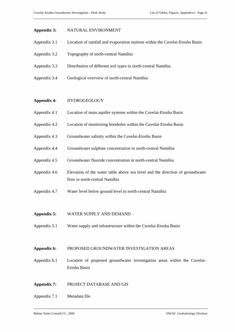
Appendix 3: NATURAL ENVIRONMENT
Appendix 3.1 Location of rainfall and evaporation stations within the Cuvelai-Etosha Basin
Appendix 3.2 Topography of north-central Namibia
Appendix 3.3 Distribution of different soil types in north-central Namibia
Appendix 3.4 Geological overview of north-central Namibia
Appendix 4: HYDROGEOLOGY
Appendix 4.1 Location of main aquifer systems within the Cuvelai-Etosha Basin
Appendix 4.2 Location of monitoring boreholes within the Cuvelai-Etosha Basin
Appendix 4.3 Groundwater salinity within the Cuvelai-Etosha Basin
Appendix 4.4 Groundwater sulphate concentration in north-central Namibia
Appendix 4.5 Groundwater fluoride concentration in north-central Namibia
Appendix 4.6 Elevation of the water table above sea level and the direction of groundwater
flow in north-central Namibia
Appendix 4.7 Water level below ground level in north-central Namibia
Appendix 5: WATER SUPPLY AND DEMAND
Appendix 5.1 Water supply and infrastructure within the Cuvelai-Etosha Basin
Appendix 6: PROPOSED GROUNDWATER INVESTIGATION AREAS
Appendix 6.1 Location of proposed groundwater investigation areas within the Cuvelai-
Etosha Basin
Appendix 7: PROJECT DATABASE AND GIS
Appendix 7.1 Metadata file

Cuvelai-Etosha Groundwater Investigation - Desk Study Notation - Page i
Bittner Water Consult CC, 2006 DWAF, Geohydrology Division
NOTATION
BGR Bundesanstalt für Geowissenschaften und Rohstoffe / Federal Institute for
Geosciences and Natural Resources.
BIWAC Bittner Water Consult, Namibia
14
C Radiocarbon: radioactive carbon isotope with the physical half-life of 5,730 yr;
the specific activity (
14
C value) is given in units of pMC referring to the
14
C
value of the NBS oxalic-acid standard.
CEB Cuvelai-Etosha Basin
CEGI Cuvelai-Etosha Groundwater Investigation
CGN Corner Geophysics Namibia (Pty) Ltd.
Limits
ClassificationEC
[mS/m]
TDS*
[mg/l]
Sulphate
[mg/l]
Nitrate–N
[mg/l]
Fluoride
[mg/l]
Class A Excellent quality water 150 1,000 200 10 1.5
Class B Good quality water 300 2,000 600 20 2.0
Class C Low risk water 400 2,600 1,200 40 3.0
Class D High risk or water unsuitable
for human consumption
> 400 > 2,600 > 1,200 > 40 > 3.0
Source: DWA, 1991: Guidelines for the evaluation of drinking water for human consumption
with reference to the chemical, physical and bacteriological quality, Windhoek.
(* Calculated from EC with multiplication factor 6.6)
DPA Discontinuous Perched Aquifer (Kalahari Sequence)
DRWS Directorate of Rural Water Supply within the Ministry of Agriculture, Water
and Forestry
DSM Directorate of Survey and Mapping
DWA Former Department of Water Affairs within the former Ministry of Agriculture,
Water and Rural Development.
DWAF Department of Water Affairs and Forestry within the Ministry of Agriculture,
Water and Forestry.
efundja Regular flooding of the Oshana system
GCS Groundwater Consulting Services (Pty) Ltd., Namibia

Cuvelai-Etosha Groundwater Investigation - Desk Study Notation - Page ii
Bittner Water Consult CC, 2006 DWAF, Geohydrology Division
GIS Geographic Information System
GNGEP German-Namibian Groundwater Exploration Project between 1992 and 1995
GROWAS National Groundwater Database
GSN Geological Survey of Namibia
GTZ German Technical Co-operation
HEM Heliborne electromagnetics
IAEA International Atomic Energy Agency
l litre
LCE Lund Consulting Engineers, Windhoek
m metre
Ma million years
m a.m.s.l. metre above mean sea level
MAWF Ministry of Agriculture, Water and Forestry
MAWRD Former Ministry of Agriculture, Water and Rural Development
m b.g.l. metres below ground level
MET Ministry of Environment and Tourism
MLRR Ministry of Land Resettlement and Rehabilitation
mS/m milli-Siemens per metre
NamPower Namibia Power Utility
NamWater Namibia Water Corporation Ltd.
NNEP Northern Namibian Environmental Project
NPC National Planning Commission
NRIS Natural Resource Information Service
NWRMR Water Resources Management Review

Cuvelai-Etosha Groundwater Investigation - Desk Study Notation - Page iii
Bittner Water Consult CC, 2006 DWAF, Geohydrology Division
omifima Local name for funnel shaped hand-dug well
omuramba Local name for ephemeral river (pl.: omiramba)
oshana Local name for the system of interconnected drainage channels that flow
through the central Owambo basin (pl.: iishana)
% percent
‰ per mille
RA Roads Authority
RWS Rural Water Supply
s second
Salinity ranges Classification TDS [mg/l] EC [mS/m]
fresh: < 1,000 < 150
brackish: 1,000 to 10,000 150 to 1,500
saline: > 10,000 > 1,500
(after PLOETHNER et al., 1997)
T Transmissivity in m
2
/day
TDS Total dissolved solids in mg/l
TGWS Tsumeb Groundwater Study
WBMC Water Basin Management Committees

Cuvelai-Etosha Groundwater Investigation - Desk Study
Bittner Water Consult CC, 2006 DWAF, Geohydrology Division
Page 1
1. INTRODUCTION
The Department of Water Affairs and Forestry (DWAF) within the Ministry of Agriculture, Water
and Forestry (MAWF) of Namibia decided to carry out a desk study prior to commencing with the
main groundwater investigation in the Cuvelai-Etosha Basin (CEB) in co-operation with the Fed-
eral Institute of Natural Resources and Geosciences (BGR). Bittner Water Consult CC (BIWAC)
was appointed to collect and provide relevant hydrogeological information.
Figure 1: Location of the Project Area
The desk study includes as recommended in the project proposal (EU ACP 2006) the review of
previous investigation results (geophysical and hydrogeological investigation programs); compila-
tion and preliminary assessment of environmental conditions, including the description of the geo-
logical setup, description of groundwater resources availability and groundwater quality; setting up
of a project database, proposal for the upgrading of the existing GROWAS database structure;
proposal of geophysical and hydrogeological investigation areas; establishment of a project GIS.

Cuvelai-Etosha Groundwater Investigation - Desk Study
Bittner Water Consult CC, 2006 DWAF, Geohydrology Division
Page 2
2. PROJECT OBJECTIVES
The overall objective of the proposed project is to achieve equitable access to and sustainable utili-
sation of water and related land and other natural resources through the implementation of inte-
grated water resources management in the CEB (EU ACP 2006).
For a successful operation of the envisaged Water Basin Management Committees (WBMC) in the
CEB, the understanding of the hydrogeological inventory in that basin is absolutely essential. The
proposed project should according to the MAWF/BGR project proposal, dated October 2004, pro-
vide hydrogeological base information and hence contribute:
• to supply adequate, clean and safe water to the rural people of the basin,
• to become more independent from shared water resources,
• to investigate into an economical use of the saline groundwater,
• to ascertain to what extent the available water will be able to support infrastructure
development including possible new growth points,
• to improve the health and standard of living of the people through the provision of a
more accessible water distribution network;
• to increase agricultural and livestock production, and possible aquaculture.
• to expand and improve the existing GROWAS data base
3. BACKGROUND AND PREVIOUS WORK
Prior to Namibia’s independence the groundwater resources of the CEB were explored mainly in
isolation for the water supply of administrative settlements, army camps or for mineral exploration
projects. Since independence in 1990, a large number of groundwater investigations on local and
regional level have been carried out in the CEB (see Appendix 1.1). In this paragraph only the
main regional studies with relevance to the whole CEB are mentioned.
First attempts to quantify the water demand of the north-central regions were done in the early
1990s, when a water master plan was compiled by the Department of Water Affairs Planning Divi-
sion (DWA, 1990). Based on this master plan a number of regional groundwater investigations
were executed by the DWA in co-operation with newly established hydrogeological consulting
firms.
A final report on the groundwater investigation in ‘Eastern Owambo’ was submitted in 1994
(GCS, 1994). The study area concentrated on a central part of the CEB between the Oshivelo-
Ondangwa-Oshikango tar-road in the west and an imaginary line between Elundu-Okankolo-
Cuvelai-Etosha Groundwater Investigation - Desk Study
Bittner Water Consult CC, 2006 DWAF, Geohydrology Division
Page 3
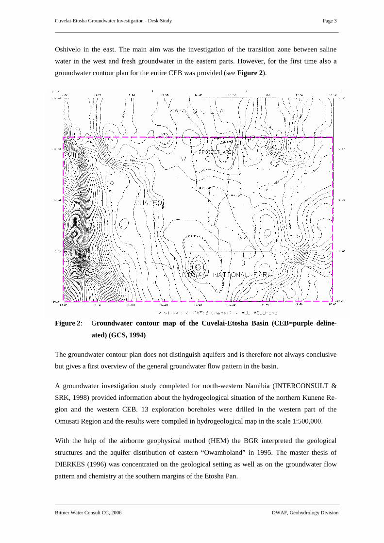
Oshivelo in the east. The main aim was the investigation of the transition zone between saline
water in the west and fresh groundwater in the eastern parts. However, for the first time also a
groundwater contour plan for the entire CEB was provided (see Figure 2).
Figure 2: Groundwater contour map of the Cuvelai-Etosha Basin (CEB=purple deline-
ated) (GCS, 1994)
The groundwater contour plan does not distinguish aquifers and is therefore not always conclusive
but gives a first overview of the general groundwater flow pattern in the basin.
A groundwater investigation study completed for north-western Namibia (INTERCONSULT &
SRK, 1998) provided information about the hydrogeological situation of the northern Kunene Re-
gion and the western CEB. 13 exploration boreholes were drilled in the western part of the
Omusati Region and the results were compiled in hydrogeological map in the scale 1:500,000.
With the help of the airborne geophysical method (HEM) the BGR interpreted the geological
structures and the aquifer distribution of eastern “Owamboland” in 1995. The master thesis of
DIERKES (1996) was concentrated on the geological setting as well as on the groundwater flow
pattern and chemistry at the southern margins of the Etosha Pan.

Cuvelai-Etosha Groundwater Investigation - Desk Study
Bittner Water Consult CC, 2006 DWAF, Geohydrology Division
Page 4
In order to achieve a basis for groundwater management a groundwater flow model and a water
balance estimation were established during the Tsumeb Groundwater Study between 1999 and
2002 by GKW CONSULT & BICON NAMIBIA concerning the area around Tsumeb. This project
also included an intensive evaluation of geophysical and remote sensing data.
The Department of Water Affairs and Forestry (DWAF) with the technical and financial assistance
of the International Atomic Energy Agency (IAEA) launched a groundwater isotope study (Project
No. NAM/8/004) in the larger Oshivelo Area of the Oshikoto Region. The major objectives of the
study were to investigate and clarify the recharge and the flow mechanism of the Oshivelo Multi-
layered Aquifer system and to identify potential risks for the groundwater quality of the area
(BAEUMLE, 2003 and HERCZEG, 2004).
The Oshivelo Groundwater Study carried out by the BGR in 1999 comprised an interpretation of
helicopter-borne as well as groundwater survey data of the Oshivelo area. The groundwater inves-
tigations of the BGR in the Oshivelo Region based on airborne-geophysical measurements were
completed with the compilation of the main hydrogeological report in 2005 (MARGANE et al.,
2005).
The subdivision of Namibia into eleven water basins and of the CEB into four sub-basins elabo-
rated by BIWAC (BIWAC, 2005) in co-operation with the DWA and the GTZ in 2004 was rec-
ommended to be useful regarding the water resource management. The resultant GIS and project
database are the basis for further application by the proposed Water Basin Management Commit-
tees (WBMC) in especially north-central Namibia. Due to the significance of the results of the
basin demarcation project for the Cuvelai-Etosha Groundwater Investigation the following chapter
summarizes the main aspects of the study.
4. BASIN DEMARCATION
The area covered by this investigation is based on the results of the basin demarcation project,
which was carried out in the framework of the integrated water resources management of Namibia.
The concept of integrated water resources management on basin level was identified by the Na-
mibian Water Resources Management Review (NWRMR) as a keystone of the Namibian reform
process in the water sector. The results of the NWRMR formed the basis for the new Water Act,
which was promulgated during December 2004.
The main objective of the basin demarcation project was to establish equally sized basins through-
out the country where relevant water matters of national and regional importance can be ade-
quately addressed. Based on an elaborated selection of criteria the whole country was then subdi-
vided into 11 water basins (BIWAC, 2004).
Cuvelai-Etosha Groundwater Investigation - Desk Study
Bittner Water Consult CC, 2006 DWAF, Geohydrology Division
Page 5
The criteria used for the demarcation of the basins were grouped into five categories, i.e. Physi-
ographic Parameters, Water Supply and Consumption, Population Density and Politi-
cal/Administrative Regions, Infrastructure, Socio-Economic and Cultural Units and Other. The
available criteria for the delimitation of each proposed basin were then considered and evaluated
with regard to importance, accuracy and relevance.
The regional focus, as shown in Figure 1, is the newly demarcated CEB in north-central Namibia,
where the establishment of a Water Basin Management Committee (WBMC) is already in an ad-
vanced stage. The main criteria for the demarcation of the Cuvelai-Etosha Basin (CEB) are primar-
ily physiological parameters such as the surface and groundwater catchment of the Etosha Pan as
lowest lying area of the intra-continental basin but also geological contact zones and political bor-
derlines are important boundaries.
In the western and southern part the proposed basin boundaries follow mainly the surface water
divides between the Etosha catchment and the Kunene and Ugab-Huab catchments, which coin-
cide often with the geological contact of the Damara Sequence and the Basement. The western
boundary of the CEB is clearly delineated by the borderline between the Omusati and Kunene
regions.
The eastern boundary of the basin follows roughly the surface and groundwater divide between the
Etosha catchment and the Omatako-Okavango catchment. The political borderline between the
Ohangwena and Oshikoto regions and the Kavango and Otjozondjupa regions, however, coincides
almost with the water divides and is therefore seen as the more practical eastern limitation of the
CEB.
The southern boundary is defined by the surface water divide but often also by the Damara Se-
quence/Basement rock contact. The basal quartzite and dolomite rocks of the Damara Sequence
represent the main groundwater recharge area of the intra-continental CEB and are, in hydro-
geological terms, considered as the outer rim of the basin. The Kaross/Otjovazandu area within the
Etosha National Park belongs geographically and historically to the Kunene catchment (west flow-
ing rivers) and was excluded from the CEB. The northern limit is given by the international border
between Angola and Namibia.
The thus, demarcated and defined CEB is considered as the project area of the Cuvelai-Etosha
Groundwater Investigation (CEGI) and all the following chapters refer to that particular area.
In order to establish more manageable units with the emphasis on local water aspects the water
basins are additionally subdivided into sub-basins. Important criteria for the delimitation are water
supply networks and sources, water consumption and land use and to a minor extent also constitu-
ency boundaries, conservancies and cultural units.

Cuvelai-Etosha Groundwater Investigation - Desk Study
Bittner Water Consult CC, 2006 DWAF, Geohydrology Division
Page 6
Within the CEB four sub-basins can be distinguished, namely the Olushandja Sub-Basin in the
west, the Iishana Sub-Basin in the centre, the Niipele Sub-Basin in the north-east and the Tsumeb
Sub-Basin in the south-east (see Figure 1). The Iishana Sub-Basin, where a Water Management
Committee was already elected, serves as a pilot area.
For the basin demarcation project available digital data was collected and presented in Arc-
View/GIS. This information should be used as basis for the proposed CEGI and should be incorpo-
rated in the project database and GIS (see Chapter 10).
5. SOCIO-ECONOMIC BACKGROUND
5.1 Political boundaries
The Project Area is mainly divided into four political regions, i.e. the Omusati, Oshana, Ohang-
wena and Oshikoto regions (the former 4-O Regions). A governor is elected for each region. The
regions are again sub-divided into 41 constituencies, which are represented by elected regional
councillors. Local governments are responsible for the issues of towns and larger villages
(MENDELSOHN et al., 2000). The regions borders are shown in Appendix 2.2.
5.2 Land use
The land of the northern regions is used by different individuals or bodies (see Appendix 2.1). A
third of the land within the CEB belongs to small-scale farmers, so-called communal farmers.
Large-scale farmers of the Tsumeb area and farmers that have fenced off big farms in the Mangetti
area make up the second category of mostly commercial and informal landowners. Furthermore,
traditional leaders control land mainly located in the south-west (Omusati Region) that is generally
open and used as grazing areas. The rest of the land like the Etosha National Park, some of the
Mangetti farms and other farms are under the control of the government and used for tourism and
conservation, resettling people, agricultural projects and for quarantining animals
(MENDELSOHN et al., 2000).
Due to climatic conditions dryland crop cultivation and large stock farming (cattle) as well as
small stock farming (goats, donkeys and poultry) are common in the northern regions while having
large herds of cattle dominates on commercial farms south of latitude 19°00 S (MOORSOM et al.,
1995). Only on some farms such as the Mangetti Dunes, Namatanga and Etunda, for example,
groundwater based irrigation is practised applying drip irrigation or sprinklers which allow the
cultivation of vegetables, maize and wheat (CHRISTELIS & STRUCKMEIER, 2001).

Cuvelai-Etosha Groundwater Investigation - Desk Study
Bittner Water Consult CC, 2006 DWAF, Geohydrology Division
Page 7
5.3 Population density
Most of the population in the CEB live in concentrated zones where fresh water is available due to
seasonal floods or to abundant water points and thus small-scale agriculture is possible (see Ap-
pendix 2.2). Therefore, a very large number of people settled in the vicinity to shallow water wells
or near to the oshana system of the Cuvelai where also more fertile soil is present (see Appen-
dix 3.2). To profit from the better infrastructure and the labour opportunities more and more peo-
ple moved into the existing growth-centres such as Ruacana, Oshakati, Ondangwa and Tsumeb,
for example. Only a few isolated villages are distributed throughout the basin (MENDELSOHN et
al., 2000).
5.4 Language and ethnical groups
Roughly eight tribes or tribal authorities are known in the north-central regions, i.e. the Kolon-
kadhi, Kwambi, Mbalantu and Mbandja are governed by a senior headman and Kwaluudhi,
Kwanyama, Ndonga and Ngandjera are ruled by kings in conjunction with senior headmen. The
predominately spoken language is Oshiwambo, while other languages such as Khoekhoegowab,
Hei!lom, Afrikaans and Otjiherero are spoken by minority groups (MENDELSOHN et al., 2000).
5.5 Road and railway infrastructure
The major roads existing in northern Namibia are the trunk road from Tsumeb to Oshikango (B1)
as well as the tar roads from Ruacana to Ondangwa (C46), from Okahao to Oshakati (C41), from
Oniipa to Oshigambo (D3629) and from Ohangwena to Elundu (C45). The borderline between the
Omusati and Kunene regions follows the Kamanjab-Ruacana road (C35) which is presently under
construction to be tarred. The new railway line between Tsumeb and Ondangwa was completed in
2006 and is in the process of being extended to Oshakati and Oshikango at the Angola border. The
infrastructure is presented in Appendix 2.2.
6. NATURAL ENVIRONMENT
6.1. Climate
The climate of the Project Area is defined as semi-arid with a characteristic rainfall gradient run-
ning from low values in the west to high values in the east and with high annual temperatures re-
sulting in also high annual evaporation rates over the entire CEB. In particular, the mean annual
rainfall ranges from only 250 mm in the south-western area and west of Ruacana to up to 600 mm
in the area around Tsumeb and towards the Kavango Region in the north-east (see Figure 3).

Cuvelai-Etosha Groundwater Investigation - Desk Study
Bittner Water Consult CC, 2006 DWAF, Geohydrology Division
Page 8
About 90 % of the annual precipitation falls from October to March, with a maximum in February.
The rainfall variability is in the range of 25 % - 40 %. Rain over the CEB usually falls during con-
vective thunderstorms; this factor has a direct impact on the presence of surface water and on the
groundwater recharge pattern (PLOETHNER et al., 1997).
Figure 3: The annual average rainfall across north-central Namibia (after
MENDELSOHN et al., 2000)
Within the Project Area the mean monthly temperatures differ from 17° C in June and July to
25° C from October until December. Generally, in the summer time the maximum daily tempera-
ture averages 30 to 35° C. During winter season the minimum temperatures decrease on average to
about 7° C (MENDELSOHN et al., 2000). Mean monthly values of relative humidity at midday
range from 50 % in March to 17 % in September. Due to the high mean annual temperatures the
groundwater temperature is generally high as well, showing values of ca. 25° C.
The high annual temperatures, the low humidity, the frequently blowing wind and the limited
vegetation cover have much influence on the mean annual potential evapotranspiration which
reach values of about 2,500 mm from September to January, before the main rainy season, and
exceeds the mean annual rainfall by a factor of about six (MENDELSOHN et al., 2000). This
means that most rainwater is lost from the system and reduces the effective rainfall to some
80 mm/annum (available to plant growth and groundwater recharge). High evaporation rates cause
the drying up of pans and omiramba (ephemeral rivers) resulting in the precipitation of salts and
increased salinity of the shallow aquifers, in particular in waterlogged areas and areas comprising a
low permeable lithology.
0 100 200 400 km N

Cuvelai-Etosha Groundwater Investigation - Desk Study
Bittner Water Consult CC, 2006 DWAF, Geohydrology Division
Page 9
6.2 Topography and landscape
From the surrounding mountains of the CEB with an elevation of on average 1,200 m a.m.s.l. on
the western rim and of about 1,500 m a.m.s.l. at the highest point of the Otavi Mountain Land in
the south-east, namely the Tsumeb hills, as well as from the eastern Kalahari (1,150 to 1,170 m
a.m.s.l), the topography declines from all directions towards the lowest point of north-central Na-
mibia, the Etosha Pan, with a minimum elevation of about 1,080 m a.m.s.l. (see Appendix 3.2).
Compared to the relief of the eastern areas the terrain to the west and south is dipping with a rela-
tively steep gradient of up to 2.8 ‰ towards the basin centre.
The topography has a major influence on the entire drainage system with the numerous intercon-
nected channels of the oshana system, which are cut into the underlying plane Kalahari sands
forming raised, vegetated areas in between. In general, the landscape of the Project Area consists
of a gently undulating, broad sandveld of low relief (0.2 ‰) averaging 1,110 m a.m.s.l. between
King Kauluma in the east and Omutsegwonime in the northwest. The Mangetti Duneveld in the
north-east is characterized by elongated east-west trending palaeo-dunes, which extend over a
distance of about 150 km into the Okavango Region. Interdune valleys, scattered pans and drain-
age lines which are filled with clayey sands are typical for the entire eastern Kalahari but limited
by the Omuramba Owambo to the thick calcrete cover of the karstfeld in the south. More abundant
are saline and mostly treeless pans and their surrounding plains in the southern part of the CEB
indicating a general flat area. Whereas remnants of old water courses are further present in the
western Kalahari receiving water only periodically due to fewer rainfalls in this dry area (see Fig-
ure 3).
6.3. Soils
After MENDELSOHN (2000) a division into nine soil types, comprising mainly sands and clays
of aeolian and fluviatile origin showing poor water-holding capacity and a low nutrient but high
salt content can be made within the CEB (see Appendix 3.3).
The Omuramba Owambo located east of the Cuvelai System forms a natural border between the
occurrences of loams and clays as well as of duricrust-like calcrete, silcrete and ferricrete depos-
ited around pan margins and along drainage lines in the south-east and the thick Kalahari sand
cover in the north-east of the Project Area (KLECZAR, 2004). The most southern regions, around
the dolomite hills near Tsumeb as well as along the western border and in the Kunene River valley
are dominated by dolomite sands with a very low water-holding capacity. The Etosha Pan, a
widely extended wind evolved depression in the lowest lying part of the CEB, represents an exten-
sive accumulation of evaporates and very fine clasts.

Cuvelai-Etosha Groundwater Investigation - Desk Study
Bittner Water Consult CC, 2006 DWAF, Geohydrology Division
Page 10
The ephemeral rivers such as the omiramba Owambo, Akazulu and Omuthiya which discharge
into the Etosha Pan consist of a highly variable fluviatile lithology comprising a mixture of gravel,
sand, silt and clay with frequently interbedded ‘hard-pan’ layers. The seasonally flooded iishana
and the surroundings of the Cuvelai System are characterized by clayey sodic sands. In the areas
adjacent to the Cuvelai, respectively around the settlements Oshikuku, Okahao, Tsandi and Outapi
sands and loams of less salinity and therefore of higher fertility prevail.
6.4. Surface water drainage
The Cuvelai Basin, as part of the larger Owambo Basin, which extends to the upper catchment of
the Cuvelai drainage system in neighbouring Angola, consists of a system of interconnected river
channels and represents an extensive inland delta similar to the Okavango Delta in Botswana but
without perennial water flow (see red drainage system in Figure 4).
Figure 4: Simplified drainage system of northern Namibia (adopted from MENDELSOHN
et al., 2000)
Cuvelai River
System
Kunene
River System
Cubango/Okavango
River System
0 50 100 200 400 km

Cuvelai-Etosha Groundwater Investigation - Desk Study
Bittner Water Consult CC, 2006 DWAF, Geohydrology Division
Page 11
Recharged in the highlands of Angola where numerous permanent rivers originate these surface
waters become ephemeral near the Namibian border and flow following the flat dipping terrain
into the Omadhiya lakes, from where they discharge via the Ekuma River into the Etosha Pan.
A smaller oshana system, which originates further east in Angola, drains central and eastern parts
of the Ohangwena Region and the north-western Oshikoto Region to reach the Etosha Pan via the
Oshigambo, Odila and Nipele rivers. Only seasonally, respectively after heavy rainfall, the iishana
are flooded by so-called efundjas from Angola and are able to reach the area around Oshakati.
There, the surface water is caught in these flat erosive depressions, from where it quickly evapo-
rates resulting in an accumulation of salts.
Generally, the surface runoff in the CEB is very limited due to an overall sandy substrate which
effects that all surface water is immediately soaked away or it is captured in one of the numerous
clayey and salty pans.
The Etosha Pan as the lowest part of the basin consequently is the major discharge area of almost
the entire region and receives water not only from the Cuvelai catchment areas but also from the
Otavi Mountain Land and the dolomite arc located in the south and west of the Project Area. Also
the ephemeral rivers (omiramba) Akazulu, Owambo and Omuthiya discharge in a westerly direc-
tion into a smaller extension of the Etosha Pan, called Fisher's Pan. The omiramba Akazulu and
Omuthiya are supported by the east-west directed inter-dune drainage system of western Kavango
and the Mangetti Duneveld while the Omuramba Owambo drains water from the foothills of the
Otavi Mountain Land between Tsumeb-Abenab in the south and Oshivelo-Tsintsabis in the north.
Both, the northern Cuvelai Drainage as well as the Etosha Pan, which drains also the south-
western dolomite arc, are considered by naming the basin Cuvelai-Etosha.
6.5 Geology
The study area is situated in the intra-continental Owambo Basin, which was formed during the
post-cretaceous tectonic development of southern Africa (MOMPER, J. A., 1982). A sedimentary
rock cover of up to 8,000 m in thickness was deposited in late Precambrian Age on top of the mid-
Proterozoic crystalline basement (Congo Craton). During the Lower Permian to Jurassic the sedi-
ments of the Nosib, Otavi and Mulden Groups of the Damara Sequence were covered by up to
360 m thick sedimentary deposits and volcanics of the Karoo Sequence. A succession of up to
600 m thick, semi-consolidated to unconsolidated sediments of the Kalahari Sequence overlay the
intrusive and extrusive rocks of Karoo Age. In Table 1 the wide suite of rocks in terms of lithol-
ogy and age are summarised. A geological overview of north-central Namibia is given in Appen-
dix 3.4.

Cuvelai-Etosha Groundwater Investigation - Desk Study
Bittner Water Consult CC, 2006 DWAF, Geohydrology Division
Page 12
6.5.1 Damara Sequence
The Damara Sequence evolved on a rifting margin, with sedimentation starting at 900 Ma with
terrestrial-fluvial sandstone of the Nosib Group. This was subsequently followed at 730 to 700 Ma
ago with carbonates of the Otavi Group. These carbonates are dominantly dolomite with some
limestone and shale deposited in a marine platform environment. At contacts to low permeable
rocks and in fault zones the carbonates became locally karstified. Finally between 650 and 600 Ma
deposition of erosion products of uplift produced the Mulden Group rocks ranging from sandstone,
siltstone and shale to carbonate. During and after the deposition of the Damara Sequence, a period
of tectonic activity resulted in faulting and folding, followed by a period of erosion. Within the
Project Area the occurrence of the Damara Sequence rocks is restricted to the western and south-
ern mountain ridges. Mainly dolomite and limestone of the Otavi Group build up the Otavi Moun-
tain Land in the south, but also phyllite, quartzite and schist of the Mulden Group and to a minor
extent quartzite, conglomerate and schist of the Nosib Group are present in the south-western
mountain rim.
6.5.2 Karoo Sequence
In the CEB Karoo Sequence rocks do not crop out at surface. The evidence from boreholes sug-
gests that the Karoo consists of fluvio-glacial sediments of the Dwyka Formation, giving rise to
tillite, sandstone and shale. Fluviatile reworking of the Dwyka Formation and a post-glacial envi-
ronment led to the deposition of shale, sandstone and carbonate of the Prince Albert Formation.
The Etjo Formation which may reach a thickness of 140 m is represented by mainly red sandstone
deposited through the action of wind during arid conditions in Jurassic times and is intersected by
several boreholes in the surroundings of Oshivelo (HEGENBERGER, 1993 and BITTNER et al.,
2001).
In late Karoo times (170 Ma) basalt of the Kalkrand Formation were intruded. Intrusive dykes,
inferred from aeromagnetic anomalies, extend throughout the area north of Tsumeb and are con-
sidered to be contemporaneous with the basalt. A north-east trending fault (at the southern margin
of the Etosha Pan and NNE trending fault (east of Oshivelo) are supposed to truncate the Karoo
sediments. The S-N trending Omniwandi Dyke Swarm is believed to be intruded during late Karoo
times as well. Periods of erosion occurred before and after the formation of the basalt. A number
of boreholes in the CEB penetrate the Karoo rocks at depth. Details of the positions and the lithol-
ogy of these boreholes are presented in INTERCONSULT & SRK, 1998, in the BGR report on the
interpretation of the helicopter survey along flight-line Tsumeb–Ondangwa (PLOETHNER et al.,
1997) and more recently in GKW & BICON, 2003a,b,c. During the recent drilling campaign at
Oshivelo Rundu (Kalkrand) basalt and Etjo sandstone was intersected at depth.
Cuvelai-Etosha Groundwater Investigation - Desk Study
Bittner Water Consult CC, 2006 DWAF, Geohydrology Division
Page 13
6.5.3 Kalahari Sequence
The Kalahari Sequence ranges from late Cretaceous to Quaternary and is entirely continental,
ranging from aeolian to fluvial. The aeolian material consists of fine-grained well-sorted sands,
while the material deposited in a fluvial environment ranges from gravel to clay and often repre-
sents braided stream conditions. The fluvial sedimentation dominates, with some reworking of
aeolian sand. The Kalahari Sequence reaches a maximum thickness of more than 600 m in the
north-east of the CEB (Okongo Area). Braided river conditions within the intra-continental basin
environment result in a vertically and horizontally very variable lithology.
Red beds (conglomerate, shale, and sandstone) at the base of the Kalahari Sequence are typical
sediments of the Ombalantu Formation. The Ombalantu Formation was recognised during explo-
ration drilling as a broad elongated sub-outcrop extending from the Andoni-Beiseb area in the
southeast to Ombalantu in the northwest.
The overlying Beiseb Formation, possibly of Eocene age, consists of a brown and grey sandstone
and/or mudstone and reaches a maximum thickness of 30 m. Within a strip trending northwest
from Oshivelo, the Beiseb Formation is overlain by reddish brown sand/sandstone of the Olukonda
Formation. The sedimentation process was not continuous, as there were periods of erosion in
between, resulting in palaeosols and fossil peneplains, which were reworked. One of such palaeo-
sols in the Olukonda Formation is believed to be an aquiferous horizon (HOAD, 1992). Borehole
WW37105 drilled some 5 km south of Oshivelo encountered saline water within the Olukonda
Formation.
The Andoni Formation consisting of semi-consolidated to consolidated sand overlies the Olukonda
Formation. Colours change from green to beige-white and brown. Calcrete has formed in all sedi-
ments of the Kalahari Sequence, and in particular it commonly forms a hard carbonate layer at the
top of the Andoni Formation, locally being karstified. Recent aeolian sand covers much of the
Project Area to various depths, especially in the area northeast of Oshivelo where relic longitudinal
dunes occur in the Mangetti Duneveld.
The surface limestone, occurring at the southern and western margin of the Cuvelai-Etosha Basin,
is interpreted as a sedimentary-evaporitic limestone, and termed Etosha Limestone Member due to
earlier studies within the Etosha National Park (DIERKES, 1996). The same limestone covers
most of the southern and western margin of the CEB, adjacent and/or on top of Damara age rocks.
6.6 Geological structures
The deep sand cover and the predominantly aeolian regime of the Kalahari make the depiction of
faults and strikes throughout the CEB difficult. The interpretation of Landsat TM images as done

Cuvelai-Etosha Groundwater Investigation - Desk Study
Bittner Water Consult CC, 2006 DWAF, Geohydrology Division
Page 14
by CORNER GEOPHYSICS (1999) reveals mainly SW-NE and NW-SE striking faults or linea-
ments as seen by SCHAEFFER (2004) but only in a different position. SCHAEFFER (2004) sug-
gests that these structures may display palaeo-environment features. Only the major faults are pre-
sented on the geological overview of north-central Namibia in Appendix 3.4.
HOAD (1993) described with the help of aerial photographs and satellite images a major fault,
namely the ‘Etosha Fault’ at the south to south-eastern margin of the Etosha Pan which seems to
be parallel to the faults along the Okavango Delta in Botswana and the Linyanti-Chobe system of
the Eastern Caprivi and the origin to the occurrence of the Etosha springs (CGN, 1999). The exis-
tence of basalt dykes and dyke swarms of Karoo Age that extend further north from the Otavi
Mountain Land is mentioned by GKW & BICON (2003c) and also by CGN (1999).
Ô<
<
F F F F F F F F F F F F F F F F F F
Ô
#Y
Ó Ó
Ó Ó
Tsumeb
Ó- late Damara (580Ma - 450Ma)
- transform type faults
- possible rejuvenation during
continental breakup (180Ma - 130Ma)
- further rejuvenation during
Tertiary compression (30Ma - 5Ma)
- compressional closed structures
- faults along cross warp fold axes
- late Damara (450Ma)
- rejuvenation during continental breakup (180Ma - 130Ma)
- open axial tensional structures
- early folding
- middle to late Damara (580Ma - 450Ma)
- open fractures and axial cleavage
(N and E trending)
- closure of the coastal branch of the Damara Orogen (580Ma)
- reactivated during continental breakup (180Ma - 130Ma)
0 50 100km
(approximate scale )
O O O O O O O O O O O O O O O O O Oùù ùù ù ùù ù ù ùù ùù ù ù ùù ùù ù ù ù ù ùù ù ù ù ù ù ù ù ù ù ù ùù ù ù ùù ù ù ùù ùù ù ù ùù ù ùù ù ù ù ù ùù ù ù ù ù ù ù ùù ù ù ù ù ù ù ùù ù ù ù ù ùù ùù ù ùù ùùù ù ù ù ùù ù ù ù ù ù ù ùù ù ù ù ù ù ùù ù ù ù ù ù ùù ùù ù ù
ù ù ù ùù ù ù ùù ùù ù ù ù ù ùù ù ù ùù ù ù ù ù ù ù ù ù ù ù ùù ù ù ù ù ùù ù ù ùù ùù ù ù ùù ù ùù ùù ù ù ù ù ù ù ù ù ùù ù ù ù ù ù ù ù ù ùù ù ùù ù ùù ùù ùù ùù ùù ù ù ùù ù ùù ù ù ù ù ù ù ù ù ùù ù ùù ù ù ù ù ù ù ù ù ù ù ù ùù ùù ù ù ùù ùù ù ù ùù ù ùù ù
- conjugate faults
- early Damara (580Ma)
rejuvenation during
(continental breakup (180Ma - 130Ma)
- open tensional faults
deep
southernedge of the Congo Craton
#
N
Figure 5: Schematic representation of the main structural elements and tectonic events of
the Otavi Mountain Land area
As part of the TGWS the structural development of the Otavi Mountain Land was studied. It was
found that major N-S trending faults along cross warp faults had developed during late Damara
times (450Ma) and were rejuvenated during continental break-up (180-130Ma). As a result open
axial tension structures had developed (Figure 5). The Tsumeb production boreholes were drilled
into these structures. In addition, NNW-SSE trending conjugate faults of early Damara age
(580Ma), rejuvenated during continental break-up (180-130Ma), and are present as open tensional

Cuvelai-Etosha Groundwater Investigation - Desk Study
Bittner Water Consult CC, 2006 DWAF, Geohydrology Division
Page 15
faults. Late Damara (580-450Ma) transform type faults are predominantly present in the western
part of the Tsumeb area. These NE-SW trending structures are compression-closed structures and
unfavourable with regard to permeability. Only where dykes have intruded these structures during
continental break-up (180-130Ma), are open and water bearing (GKW & BICON, 2003a).
Table 1: Stratigraphy and lithology of the Project Area (after PLOETHNER et al., 1997
and GKW & BICON, 2003 a, b)
SYSTEM SEQUENCE
(AGE)
GROUP SUB-
GROUP
FORMATION LITHOLOGY THICKNESS
MAX. [m]
Quaternary Alluvium Calcrete, sand n/a
Etosha Limestone
Member
Limestone, calcrete, sand 100
Andoni Sand, sandstone, silt, 275
Olukonda Sand, sandstone, silt 175
Tertiary
KALAHARI,
(< 120 Ma)
Beiseb Sandstone, mudstone, gravel 50
Cretaceous Ombalantu Mudstone 100
DISCONFORMITY
Kalkrand (Rundu) Basalt 90
Jurassic Etjo Sandstone 140
Triassic Prince Albert Shale, silt- and sandstone, coal 285
(equivalent to
Omingonde)
Lower
Permian
KAROO
(120-400
Ma)
Ecca
Dwyka Tillite, shale 160
Carboniferous
Devonian
Silurian
Ordovician
Cambrian
EROSION / DISCONFORMITY (280-450 Ma)
Owambo
Sandstone, siltstone, shale, dolomite,
limestone
2,600
Kombat Phyllite, dolomite, conglomerate, shale >500Mulden
Tschudi
Sandstone, siltstone, minor conglom-
erate, shale
1,800
DISCONFORMITY (570-760 Ma)
Huettenberg Dolomite, limestone, shale, tillite, chert 840
Elandshoek Dolomite >1,200
Maieberg Dolomite, limestone, shale beds 880
Tsumeb
Chuos Quartzite, tillite, shale 200
DISCONFORMITY
Auros Dolomite, limestone with shale 350
Gauss Dolomite, sandstone, limestone 750
Otavi
Abenab
Berg Aukas Dolomite, limestone 550
DISCONFORMITY (830-840 Ma)
Ghaub (Varianto) Tillite, pyroclastics, ironstone
Askevold Phyllite, agglomerate
Namibian
DAMARA
(650-900
Ma)
Nosib
Nabis
Shale, phyllite, quartzite, arkose, con-
glomerate
>1,200
Mokolian (>1,800 Ma) DISCONFORMITY (950-1,500 Ma)
(Basement) Granite, gneiss, schist, meta-gabbro n/a

Cuvelai-Etosha Groundwater Investigation - Desk Study
Bittner Water Consult CC, 2006 DWAF, Geohydrology Division
Page 16
HOAD (1993) believes that the high grade of folding and faulting of the Otavi and Mulden Groups
striking east-west created the prerequisite for the karstification of the dolomites and thus, for the
high groundwater potential of the aquifers.
7. HYDROGEOLOGY
7.1 Main groundwater flow and aquifer systems
All groundwater within the CEB flows towards the Etosha Pan, which is the area of lowest eleva-
tion in the basin. Three main groundwater flow systems can be distinguished within the CEB.
a) Groundwater recharged in the fractured dolomites of the Damara Sequence, which form
the southern and western rim of the basin, flows north- and eastwards and feeds the aqui-
fer system of the Karoo and Kalahari sequences. However, a major part of this
north/eastbound groundwater flow is shallow, and discharges through numerous springs
along the southern margin of the Etosha Pan, where it rapidly evaporates.
b) A deep-seated multi-layered Kalahari Aquifer is recharged in Angola and groundwater
flows in a southern direction towards the Etosha Pan and the Okavango River.
c) A shallow Kalahari Aquifer (formerly described as the brine lake area) superimposes both
previously described aquifer systems in the central part of the CEB. The mainly saline
groundwater originates from regular floods in the Cuvelai drainage, which has its headwa-
ters in central Angola.
Furthermore, six main aquifer systems can be distinguished within the CEB, namely the Otavi
Dolomite Aquifer (DO) located on the western and southern rim, followed in the north by the Eto-
sha Limestone Aquifer (KEL), the Oshivelo Multi-layered Aquifer (KOV) in the eastern area, the
Ohangwena Multi-layered Aquifer (KOH) in the north-eastern parts, the Oshana Multi-layered
Aquifer (KOS) covering the area of the Cuvelai drainage system and the Omusati Multi-zoned
Aquifer (KOM) situated in the west adjacent to the KOS.
The schematic map in Appendix 4.1 is a first attempt to give an overview of the location of the
aquifer systems within the intra-continental CEB. The extent of most of these aquifers is not yet
properly defined and some aquifers intermingle or overlie/underlie others (e.g. KEL on top of DO
or KOS on top of KOH). It will be one of the tasks of the planned groundwater investigation to
get more clarity on the actual groundwater systematic in the CEB.

Cuvelai-Etosha Groundwater Investigation - Desk Study Page 17
Bittner Water Consult CC, 2006 DWAF, Geohydrology Division
Table 2: Definition of aquifers within the Cuvelai-Etosha Basin (after BIWAC, 2003)
NAME OF AQUIFER/AQUITARD
NEW
ABBREVIATION
FORMER
ABBREVIATION
SEQUENCE
GROUP
(SUBGROUP)
FORMATION
Kalahari Sequence Aquifer (undifferentiated) K N/A
Ombalantu., Beiseb, Olukonda , Andoni ,
Etosha Limestone M., Recent
Discontinuous Perched Aquifer KDP DPA Recent
Etosha Limestone Aquifer KEL UKAEL
Andoni (Etosha Limestone Member)
Oshivelo Multi-layered Aquifer (undifferentiated) KOV N/A Ombalantu, Beiseb, Olukonda, Andoni
• Aquifer 1 KOV1 UKAAN
Andoni .
• Aquifer 2 KOV2 OAAAN
Andoni, Olukonda.
Oshana Multi-layered Aquifer (undifferentiated) KOS N/A Ombalantu, Beiseb, Olukonda, Andoni
• Aquifer 1 KOS1 MSAAN
Andoni
Ohangwena Multi-layered Aquifer (undifferentiated) KOH N/A Andoni, Olukonda
• Aquifer 1 (Andoni Fm) KOH1 MDAAN
Andoni, Olukonda
• Aquifer 2 (Olukonda Fm) KOH2 VDAOL
Olukonda
Omusati Multi-zoned Aquifer (undifferentiated) KOM N/A
Kalahari
Ombalantu, Beiseb, Olukonda, Andoni
Karoo Sequence Aquifer/Aquitard (undifferenti-
ated)
KR KSA Karoo Ecca
Dwyka , Omingonde, Prince Albert, Kalkrand,
Etjo
Damara Sequence Aquifer (undifferentiated) D N/A Mulden-, Otavi-, Nosib-
Owambo, Kombat, Tschudi, Huettenberg,
Elandshoek, Maieberg, Ghaub, Auros, Gauss,
Berg Aukas, Varianto, Nabis
Mulden Group Aquifer/Aquitard (undifferentiated) DM MGA Mulden Owambo, Kombat, Tschudi
Otavi Dolomite Aquifer (undifferentiated) DO ODA Otavi
Huettenberg, Elandshoek, Maieberg, Ghaub,
Auros, Gauss, Berg Aukas, Varianto, Nabis
DOT ODA Tsumeb Subgroup
DOT1 ODA Huettenberg
DOT2 ODA Elandshoek
DOT3 ODA Maieberg
DOT4 ODA
Otavi
(Tsumeb Subgroup)
Ghaub
DOA ODA Abenab Subgroup
DOA1 ODA Auros
DOA2 ODA Gauss
Otavi Dolomite Aquifer
DOA3 ODA
Otavi
(Abenab Subgroup)
Berg Aukas
Nosib Group Aquifer/Aquitard (undifferentiated) DN N/A
Damara
Nosib Varianto, Nabis
Pre-Damara Basement (undifferentiated) B B Basement

Cuvelai-Etosha Groundwater Investigation - Desk Study Page 18
Bittner Water Consult CC, 2006 DWAF, Geohydrology Division
7.2 Groundwater quality
The main aquifer systems present in the CEB show similar characteristics regarding the water
quality changes along the flow path. Starting from the basin margins in the south and west the
groundwater salinity generally increases towards the basin centre due to higher concentrations of
chloride, sodium, fluoride and sulphate (see Appendices 4.3, 4.4 and 4.5). Groundwater of good
quality prevails along the southern rim of the Etosha Pan, respectively in much of the Tsumeb
Sub-Basin as well as in the Niipele and south-western Olushandja Sub-basins, and in the Uuk-
waluudhi area southeast of Ruacana. Locally, shallow seasonal freshwater lenses occur within
those central areas of brackish to saline groundwater specifically after flood events in the Cuvelai
drainage system of the Iishana Sub-Basin (BIWAC, 2005).
The characteristics of the main aquifers are described in detail in the following starting with outer
basin (older rocks forming the basin rim) towards the inner basin (younger deposits filling the
basin centre).
7.3 Characteristics of the main aquifers
7.3.1 Damara Sequence Aquifers
The Damara Sequence aquifer differentiation is based on geological units rather than local occur-
rence, like it was done for the Kalahari Sequence aquifers. The individual aquifers and aquitards
are rather associated with geological formations (Table 2). There are facies changes within the
individual geological formations in the CEB and the aquifer potential of e.g. the Hüttenberg For-
mation Aquifer (DOT1) is not homogenous throughout the basin but for practical reasons is con-
sidered as one large aquifer unit.
Based on experience in the area south of Tsumeb the Nosib Group quartzite and shale rocks (DN)
are considered to be mainly aquitards. The values of transmissivity range from 0.2 to 3 m
2
/day,
depending on the occurrence of tectonic features such as faults. As part of the TGWS, exploration
borehole WW39991 was drilled on farm Nabis south of Tsumeb to a final depth of 141 m. Cal-
crete (0-9 m) and Nosib Group quartzitic sandstone (9-141 m) were encountered. Fresh water was
struck at 61 m, 91 m and 132 m depth and a blow yield of 1.5 m
3
/h was measured (GKW &
BICON, 2001c).
The carbonates of the Otavi Dolomite Aquifer (DO) constitute a thick fractured and partly karsti-
fied aquifer system representing the main hardrock aquifer of the southern and western CEB. From
top down, the Otavi Dolomite Aquifer is composed of the fractured to karstified dolomite aquifer
of the Hüttenberg (DOT1), Elandshoek (DOT2) and upper Maieberg (DOT3) formations (Tsumeb
Subgroup).

Cuvelai-Etosha Groundwater Investigation - Desk Study Page 19
Bittner Water Consult CC, 2006 DWAF, Geohydrology Division
The lower Maieberg as well as the Chuos formations, which separate the upper Tsumeb Subgroup
from the lower Abenab Subgroup, act as aquitards. The dolomites of the Elandshoek and Hütten-
berg formations have the highest average transmissivity values of 300 and 1700 m
2
/day respec-
tively and are therefore the most important fresh water aquifers in the outer rim of the CEB. The
fractured dolomites of the Auros, Gauss and Berg Aukas formations (DOA) represent the major
lower dolomite aquifer with transmissivity values ranging from 10 to 1000 m
2
/day. The main out-
crop areas of the DOA in the CEB are in the Abenab Area and northeast of Otjovazandu in the
Etosha National Park (DWA, 1996).
The groundwater flow is directed towards the centre of the CEB, the Etosha Pan. Subsequently
groundwater recharged in the fractured dolomites of the Otavi Mountain Land (DO) flows also
north- and eastwards feeding the overlying unconfined and confined Kalahari aquifers
(KEL+KOV1 and KOV2) via faults and hydrogeological "windows".
The mostly fine-grained meta-sediments of the Mulden Group (shale, quartzite) as well as the
Nosib Group rocks are generally regarded as aquitards (DM). Locally, however, and when con-
fined under Kalahari Sequence sediments, e.g. in western Omusati (see Figure 5) or near Okau-
kuejo (T=300 m
2
/day, DIERKES 1996) they could contain abstractable volumes of mostly fresh
groundwater.
Northwest of Tsumeb on the farm Klein Ottlau, the DM was also intersected by exploration bore-
hole WW39984. The drill intersected thick calcrete (0-44 m), Mulden Group quartzite (44-72 m)
and Mulden Group shale (72-224 m). Fresh water was struck within the quartzite at 63 m depth
and the blow test resulted in a measured yield of 15 m
3
/h (GKW & BICON, 2003c).
7.3.2 Karoo Sequence Aquitards
In the central CEB, the Karoo rock succession is made up of glaciogenic rocks (largely tillite in-
terbedded with shale) of the Dwyka Formation, shales and coals of the Prince Albert Formation,
and aeolian sandstone of the Etjo Formation (at Nanzi and recently reported from Oshivelo,
BITTNER et al., 2004). Aeromagnetic surveys indicate basaltic lavas equivalent to the Rundu
Formation in the south-east of the basin beneath the Kalahari succession (CGN, 1999). Recent
deep drilling between Tsumeb and Oshivelo as part of the Tsumeb Groundwater Study (GKW &
BICON, 2003 a, b, c) proved that impermeable Karoo sediments such as shale and mudstone as
well as basalt are ‘sandwiched’ between the upper Kalahari sediments and the lower Otavi dolo-
mites. The Karoo Sequence aquitard (KR) comprises rocks like shale, mudstone, sandstone and
basalt. It is mainly described as aquitard (Transmissivity values between 1 and 10 m
2
/day) but can
locally yield abstractable volumes of groundwater, often when confined under Kalahari sediments.

Cuvelai-Etosha Groundwater Investigation - Desk Study Page 20
Bittner Water Consult CC, 2006 DWAF, Geohydrology Division
The Karoo aquitard separates hydraulically the underlying Otavi Dolomite aquifers from the over-
lying Kalahari aquifers except where dolomite mountains crop out at or near surface, e.g. at Halali,
or (postulated, see MARGANE et al., 2005) south of Oshivelo, due to rough pre-Kalahari and -
Karoo topography. In these hydrogeological window areas hydraulic contact between Otavi
Dolomite aquifers and the Kalahari aquifers is possible allowing recharge by lateral throughflow
from the rim towards the centre of the basin.
Only the aeolian Etjo Formation sandstone (forming also the Waterberg Plateau east of Otji-
warongo) can be considered an aquifer. Its presence in the Oshivelo area was already reported
during earlier drilling campaigns (HEGENBERGER, undated) but was recently intersected again
in two exploration boreholes WW40935 and WW40967 at depths > 200m. The transmissivity of
this aquifer unit was determined as 82 and 300 m
2
/day respectively. The regional extent of the Etjo
sandstone is, however, not known and is most probably limited.
7.3.3 Kalahari Sequence Aquifers
Fluvial sedimentation dominates with some reworking of aeolian sand. Lacustrine clays and asso-
ciated fluvial silts and sands were most probably transported by endorheic rivers flowing south
from northern directions, similarly to the way that the Okavango River now feeds the Okavango
Swamps. The present Etosha Pan floor consists of evaporitic calcareous sandstones covered by a
thin layer of salt-bearing chalk (STRUCKMEIER & CHRISTELIS, 2001).
The Kalahari aquifers are subdivided into five major units and named after the region or locality
where they occur or where they were first described (BIWAC, 2003). The Discontinuous Perched
Aquifer (KDP) represents a series of shallow, only locally occurring aquifers of limited extent and
is therefore not considered in the aquifer distribution map in Appendix 4.1. This aquifer type is
present mainly in the Niipele Sub-Basin where recent dune sand covers the underlying sediments
of the Kalahari Sequence. The KDP is recharged by direct infiltration of rainwater and exploited
by means of traditional funnel-shaped hand-dug wells, so called omifima. Although the yield is
generally limited by the size of the aquifers, they provide easily accessible and good quality drink-
ing water to the scattered villages in the Ohangwena and Oshikoto regions.
The Etosha Limestone Aquifer (KEL) is present at the southern and western margin of the CEB
with a thickness of locally more than 100 m. It is believed to be a groundwater calcrete of sedi-
mentary-evaporitic genesis. The KEL constitutes an economically important aquifer because of its
easy accessibility (shallow water table) and often good yields and water quality. High yields are
reported from the area southeast of Oshivelo, along the Omuramba Owambo, south of Halali in the
Etosha National Park and locally in the western Olushandja Sub-Basin.
Cuvelai-Etosha Groundwater Investigation - Desk Study Page 21
Bittner Water Consult CC, 2006 DWAF, Geohydrology Division
The aquifer is partly recharged by lateral throughflow from the DO aquifers of the basin margin
but isotope studies showed that local recharge to the KEL contributes by more than 70 % to the
north-westerly groundwater flow (GEYH, 1997). The groundwater vulnerability is relatively high
and elevated nitrate concentrations are often measured particularly when the borehole is located
near a livestock kraal.
The Oshivelo Multi-layered Aquifer (KOV) was first intersected at Oshivelo from where it ex-
tends in a north-western and eastern direction towards Tsintsabis and the Kavango Region border.
Parts of the aquifer (KOV2) are confined, covered by brown-green clay, calcrete and clayey sand.
At Oshivelo and towards the Etosha Pan, (at elevations lower than 1100 m b.s.l.) the aquifer is
artesian with free flowing yields of up to 200 m
3
/h. The aquifer material comprises mainly gravel
and sand but also karstified calcrete/dolocrete. Transmissivity values between 100 and
10,000 m
2
/day are reported. The yields can be very high (>200 m
3
/h) but decrease towards the
northwest where the aquifer is less permeable. The aquifer was the subject of a number of
groundwater investigations and most recently studied by the BGR/DWA as part of a larger project
investigating groundwater occurrences in north-eastern Namibia (MARGANE et al., 2005). It is
assumed that recharge to the KOV2 is to a high percentage via throughflow from the KEL and to
a lesser extent from the underlying DOT. A groundwater isotope investigation of the DWA in co-
operation with the IAEA resulted in the interpretation that the isotope signature of the KOV2
could be a product of mixing of water originating from the KEL and the DO (DWA, 2004). Pre-
liminary calculations of the potential groundwater throughflow from the KEL to the freshwater
portion of the KOV2 resulted in a value of 8 Mm
3
/annum and a safe yield of 4 Mm
3
/annum
(BIWAC, 1999). The recently completed groundwater study in the Oshivelo area comes to the
same conclusion (MARGANE et al., 2005).
The Ohangwena Aquifer (KOH) is a multi-layered continuous porous aquifer of the eastern
Ohangwena and northern Oshikoto regions. The upper KOH1 aquifer comprises green-beige
semi-consolidated sandstone of the Andoni Formation at depths between about 60 m and
160 m b.g.l., and represents the main freshwater source of the Niipele Sub-Basin. It contains more
than 10 billion m
3
of potable groundwater (estimation by the author). At this stage about
300,000 m
3
are abstracted per annum for water supply to scattered villages. Yields between 3 and
50 m
3
/h and transmissivity values between T = 30 and 760 m
2
/day are reported. West of the line
Eenhana-Okankolo and towards the King Kauluma area in the south the water quality of the KOH
is brackish to saline, mixing with the shallow saline groundwater of the Cuvelai drainage system
(KOS). The KOH1 is recharged by lateral throughflow from a proposed unconfined Kalahari aq-
uifer in southern Angola. Isotope values of groundwater samples which are taken in the northern
Ohangwena Region close to the border to Angola show a relatively young conventional
14
C age
(GEYH, 1997) thus demonstrating the proximity of the recharge area.

Cuvelai-Etosha Groundwater Investigation - Desk Study Page 22
Bittner Water Consult CC, 2006 DWAF, Geohydrology Division
The deeper-seated KOH2 aquifer (intersected between 130 m and 380 m b.g.l. depth) is repre-
sented by red sandstone and clay of the Olukonda Formation. In the Eenhana area the KOH2 con-
tains fresh water under a layer of brackish water in the KOH1 aquifer.
The Oshana Aquifer (KOS) is shallow (6 – 80 m) unconfined aquifer system which comprises a
relatively thick sequence of alluvial deposits of the Andoni Formation. Groundwater bearing sand
and sandstone layers are from a lacustrine and deltaic environment and have a good storage capac-
ity. However, with seasonal and constantly shifting depositional environment, the resulting cross-
bedding of sandstones and clay layers limits the hydrogeological properties. Clays have a lower
specific yield than sandstones and sandy layers. Clay layers can therefore act as aquitards and can
hamper the relatively easy flow of groundwater into the basin.
The KOS1 is recharged mainly by regular flooding of the oshana drainage system by so-called
efundjas, originating in Angola. The water level gradient is very flat, and the groundwater flow in
the Oshana Region is generally towards the Etosha Pan (GCS, 1994). The piezometric level con-
tours in Appendix 4.6 indicate a flow in a south-easterly direction where the groundwater is dis-
charged and subsequently evaporated in low elevation areas of the Etosha and Fisher’s pans. The
aquifer is tapped by a series of hand-dug wells, which supplied the bulk of the water used by the
population in the Iishana Sub-Basin during the dry season prior to the construction of the pipeline
network from the Kunene River. The KOS occurs in most of the Iishana Sub-Basin, the western
and north-western parts of the Niipele and Tsumeb sub-basins respectively and the eastern part of
the Olushandja Sub-Basin. The water quality varies from brackish to saline with local freshwater
lenses in the oshana channels. A small number of boreholes were drilled into the KOS and yields
of up to 30 m
3
/h are reported. Aquifer parameters such as transmissivity values are, however, not
recorded.
The Omusati Multi-zoned Aquifer (KOM) comprises unconsolidated to semi-consolidated sedi-
ments of the Kalahari Sequence, mainly sand, clay and calcrete/dolocrete but also large evaporitic
deposits. The groundwater quality is mainly brackish with shallow freshwater in places. The aqui-
fer is separated from the KOS because it is not recharged by the Cuvelai drainage system. Re-
charge takes place by means of lateral throughflow from the KEL and DO aquifers in the west.
The salinity of the subsurface sediments is, however, high, causing the deterioration of groundwa-
ter quality in flow direction towards the basin centre. The change can be very sudden with fresh-
water boreholes in the KEL being only a few kilometres away from boreholes with saline
groundwater in the KOM. The change in salinity is believed to be caused by the ancient proto-
Etosha Lake, covering most of the central CEB. Thick evaporitic deposits of the playa-lake re-
mained after rapid evaporation of seasonal water inflow from northern directions. The salts have
been dissolved by rainwater resulting in the brine lake conditions throughout the central CEB.

Cuvelai-Etosha Groundwater Investigation - Desk Study Page 23
Bittner Water Consult CC, 2006 DWAF, Geohydrology Division
Table 3: Characteristics of the main aquifers within the Cuvelai-Etosha Basin
AQUIFER OCCURENCE AQUIFER CHARACTERISTICS AQUIFER LITHOLOGY
WATER
STRIKE
[m b.g.l.]
WATER QUALITY
BOREHOLE
YIELD
[m
3
/h]
TRANSMISSIVITY
[T m
2
/day]
KEL
foreland of dolomite mountain
land, Tsumeb and Olushandja
sub-basins
mainly fractured, often karstified,
locally porous, unconfined
dolocrete, calcrete/limestone,
sand
10-100
fresh, locally high
nitrate concentrations
3-100 ?
KOV2
between omiramba Owambo
and Omuthiya, Tsumeb Sub-
basins
mainly porous, locally fractured
and artesian, confined
conglomerate, sand, sand-
stone, dolocrete, calcrete
30-150 fresh to brackish 25-200? 100-10000
KOS Cuvelai drainage
mainly porous, locally fractured;
unconfined
sand, calcrete/limestone 6-80 saline to hypersaline 1-30 N/A
KOH1
eastern Ohangwena and Oshi-
koto regions, Niipele Sub-basin
mainly porous, locally fractured;
confined
Sand, sandstone 60-180 fresh to brackish 3-50 30-760
DOT1
Southern and western basin rim,
Tsumeb and Olushandja sub-
basins
fractured, often karstified, partly
confined
dolomite 20-250 fresh >100
120-5500
variable
DOT2
Southern and western basin rim,
Tsumeb and Olushandja sub-
basins
fractured, locally karstified, partly
confined
dolomite 50-250 fresh >50
15-1250
variable
DOA
Southern and western basin rim
(only locally), Tsumeb and
Olushandja sub-basins
fractured, locally karstified, partly
confined
dolomite 30-250 fresh >50
10-1000
variable
Cuvelai-Etosha Groundwater Investigation - Desk Study Page 24
Bittner Water Consult CC, 2006 DWAF, Geohydrology Division
Large gypsum deposits still exist as proof for the existence of the Proto-Etosha Lake (BIWAC,
2000). The gypsum is responsible for the high sulphate concentration in the groundwater of the
KOM (Appendix 4.4).
The south-eastern part of the Omusati Region is scarcely populated mainly due to the missing
fresh groundwater and surface water sources. Only scattered cattle posts exist, where the herders
have to be supplied with trucked-in drinking water from the north. This area is considered as one
of the main investigation areas of the upcoming groundwater investigation in the CEB.
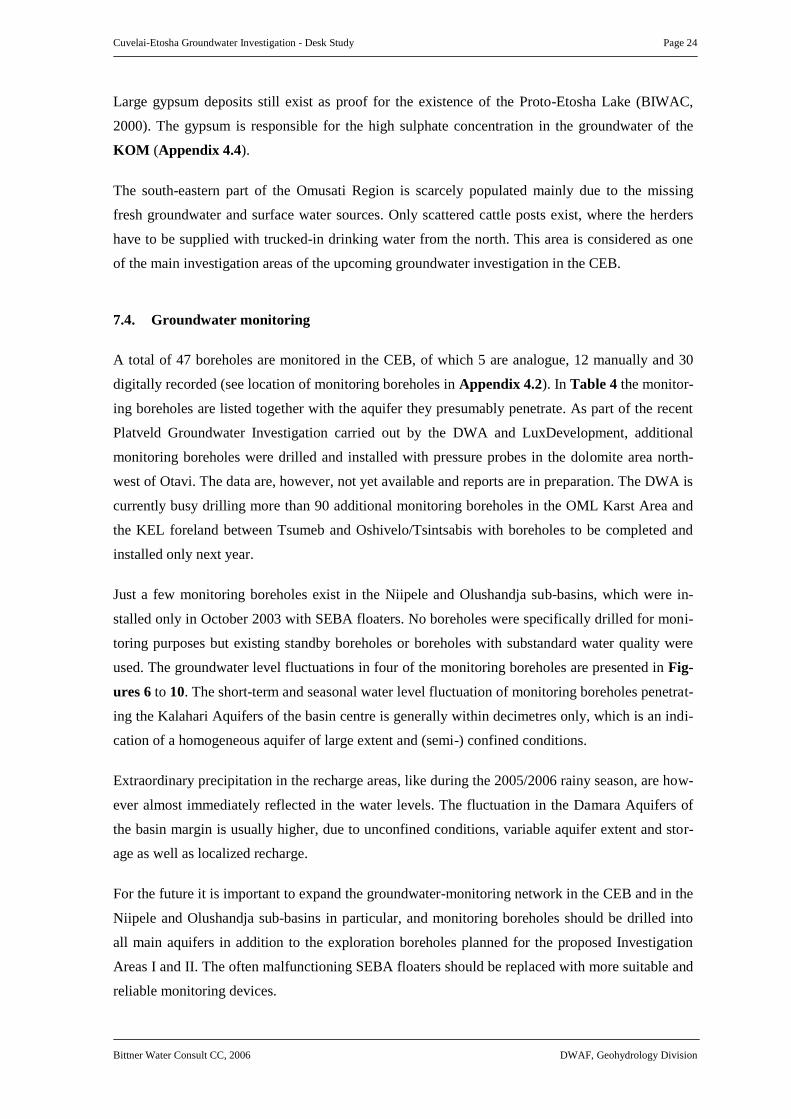
7.4. Groundwater monitoring
A total of 47 boreholes are monitored in the CEB, of which 5 are analogue, 12 manually and 30
digitally recorded (see location of monitoring boreholes in Appendix 4.2). In Table 4 the monitor-
ing boreholes are listed together with the aquifer they presumably penetrate. As part of the recent
Platveld Groundwater Investigation carried out by the DWA and LuxDevelopment, additional
monitoring boreholes were drilled and installed with pressure probes in the dolomite area north-
west of Otavi. The data are, however, not yet available and reports are in preparation. The DWA is
currently busy drilling more than 90 additional monitoring boreholes in the OML Karst Area and
the KEL foreland between Tsumeb and Oshivelo/Tsintsabis with boreholes to be completed and
installed only next year.
Just a few monitoring boreholes exist in the Niipele and Olushandja sub-basins, which were in-
stalled only in October 2003 with SEBA floaters. No boreholes were specifically drilled for moni-
toring purposes but existing standby boreholes or boreholes with substandard water quality were
used. The groundwater level fluctuations in four of the monitoring boreholes are presented in Fig-
ures 6 to 10. The short-term and seasonal water level fluctuation of monitoring boreholes penetrat-
ing the Kalahari Aquifers of the basin centre is generally within decimetres only, which is an indi-
cation of a homogeneous aquifer of large extent and (semi-) confined conditions.
Extraordinary precipitation in the recharge areas, like during the 2005/2006 rainy season, are how-
ever almost immediately reflected in the water levels. The fluctuation in the Damara Aquifers of
the basin margin is usually higher, due to unconfined conditions, variable aquifer extent and stor-
age as well as localized recharge.
For the future it is important to expand the groundwater-monitoring network in the CEB and in the
Niipele and Olushandja sub-basins in particular, and monitoring boreholes should be drilled into
all main aquifers in addition to the exploration boreholes planned for the proposed Investigation
Areas I and II. The often malfunctioning SEBA floaters should be replaced with more suitable and
reliable monitoring devices.

Cuvelai-Etosha Groundwater Investigation - Desk Study Page 25
Bittner Water Consult CC, 2006 DWAF, Geohydrology Division
Monitoring borehole WW34470 at Onayena KOH2 aquifer
April 2005 - June 2006
4.25
4.30
4.35
4.40
4.45
4.50
4.55
26.04.05 16:34:45 15.06.05 16:34:45 04.08.05 16:34:45 23.09.05 16:34:45 12.11.05 16:34:45 01.01.06 16:34:45 20.02.06 16:34:45 11.04.06 16:34:45 31.05.06 16:34:45
Date/time
Gro
un
dw
ate
r le
ve
l [m
b
.s
u.]
Recharge during 2006 rainy season
Figure 6: Groundwater level graph of monitoring borehole WW 34470 penetrating the confined
KOH2 at a depth >300 m. Only little fluctuation is noticeable
Monitoring borehole WW36091 at Onhunda KOH1 aquifer
April 2005 - June 2006
50.50
51.00
51.50
52.00
52.50
53.00
27.04.05 09:24:5616.06.05 09:24:5605.08.05 09:24:5624.09.05 09:24:5613.11.05 09:24:5602.01.06 09:24:5621.02.06 09:24:5612.04.06 09:24:5601.06.06 09:24:56
Date/time
Gro
un
dw
ate
r le
ve
l [m
b
.s
u.]
Recharge during rainy season 2006Logger stuck
Figure 7: Groundwater level graph of monitoring borehole WW 36091 penetrating the KOH1
aquifer near the Angola border. Short-term fluctuation is due to pumping of nearby production bore-
hole and tidal effects.
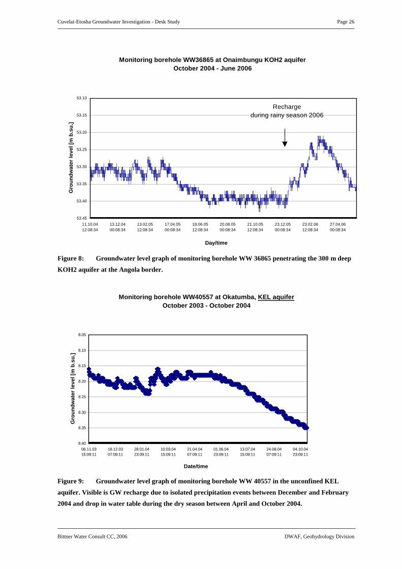
Cuvelai-Etosha Groundwater Investigation - Desk Study Page 26
Bittner Water Consult CC, 2006 DWAF, Geohydrology Division
Monitoring borehole WW36865 at Onaimbungu KOH2 aquifer
October 2004 - June 2006
53.10
53.15
53.20
53.25
53.30
53.35
53.40
53.45
11.10.04
12:08:34
13.12.04
00:08:34
13.02.05
12:08:34
17.04.05
00:08:34
18.06.05
12:08:34
20.08.05
00:08:34
21.10.05
12:08:34
23.12.05
00:08:34
23.02.06
12:08:34
27.04.06
00:08:34
Day/time
Gro
un
dw
ate
r le
ve
l [m
b
.s
u.]
Recharge
during rainy season 2006
Figure 8: Groundwater level graph of monitoring borehole WW 36865 penetrating the 300 m deep
KOH2 aquifer at the Angola border.
Monitoring borehole WW40557 at Okatumba, KEL aquifer
October 2003 - October 2004
8.05
8.10
8.15
8.20
8.25
8.30
8.35
8.40
06.11.03
15:09:11
18.12.03
07:09:11
28.01.04
23:09:11
10.03.04
15:09:11
21.04.04
07:09:11
01.06.04
23:09:11
13.07.04
15:09:11
24.08.04
07:09:11
04.10.04
23:09:11
Date/time
Gro
un
dw
ate
r le
ve
l [m
b
.s
u.]
Figure 9: Groundwater level graph of monitoring borehole WW 40557 in the unconfined KEL
aquifer. Visible is GW recharge due to isolated precipitation events between December and February
2004 and drop in water table during the dry season between April and October 2004.

Cuvelai-Etosha Groundwater Investigation - Desk Study Page 27
Bittner Water Consult CC, 2006 DWAF, Geohydrology Division
Figure 10: Groundwater level graph of monitoring borehole WW 35825 in the unconfined dolomite
aquifer northeast of Otjovazandu at the basin margin.
Monitoring borehole WW35825 at Dolomietpunt, DOT3 aquifer
October 2003 - April 2004
31.50
32.00
32.50
33.00
33.50
34.00
34.50
35.00
05.11.03
13:48:07
07.01.04
01:48:07
09.03.04
13:48:07
11.05.04
01:48:07
12.07.04
13:48:07
13.09.04
01:48:07
14.11.04
13:48:07
16.01.05
01:48:07
19.03.05
13:48:07
Date/time
Gro
un
dw
ate
r le
ve
l [m
b
.s
u.]
Recharge during 2005 rainy season
No recharge during 2004 rainy season

Cuvelai-Etosha Groundwater Investigation - Desk Study Page 28
Bittner Water Consult CC, 2006 DWAF, Geohydrology Division
Table 4: Monitoring boreholes in the Cuvelai-Etosha Basin
NO REGION FARM OR LOCATION AQUIFER WW-NO.
TYPE OF
MEASUREMENT
1 Ohangwena Onehova KOH1 36091 Digital Recorder
2 Ohangwena Omulonga KOH1 36691 Digital Recorder
3 Ohangwena Eendobe KOH1 36694 Digital Recorder
4 Ohangwena Onaimbungu KOH2 36865 Digital Recorder
5 Omusati Ondambo_I KOM 40557 Digital Recorder
6 Omusati Dolomietpunt, Etosha Park DOT3 35825 Digital Recorder
7 Oshikoto Bloubokdraai tower KOV1 6320 Analogue Recorder
8 Oshikoto Namutoni Gate KOV1 93168 Analogue Recorder
9 Oshikoto Tsumeb DOT 10316 Analogue Recorder
10 Oshikoto Onalusheshete KOH1 36690 Digital Recorder
11 Oshikoto Onayena KOH2 34470 Digital Recorder
12 Oshikoto Ondjaba KOH2 36869 Digital Recorder
13 Oshikoto Oshivelo KOV1 37442 Digital Recorder
14 Oshikoto Welgevonde 850 KR 39988 Digital Recorder
15 Oshikoto Vredelus 869 KEL 39994 Digital Recorder
16 Oshikoto Okatumba KEL 40363 Digital Recorder
17 Oshikoto Guinas DOT 30893 Digital Recorder
18 Oshikoto Driefontein Tamboti 864 KEL/DOT 31485 Digital Recorder
19 Oshikoto Tsumeb DOT 33311 Digital Recorder
20 Oshikoto Tsumore-Ongopolo Pty Ltd DOT 37977 Digital Recorder
21 Oshikoto Dannevis Nord 48 DO 39083 Digital Recorder
22 Oshikoto Nosib III DN 39972 Digital Recorder
23 Oshikoto Boschecke DOT2 39973 Digital Recorder
24 Oshikoto Scott DOT1 39986 Digital Recorder
25 Oshikoto Otjikoto Lake DOT 81280 Digital Recorder
26 Oshikoto Onkoshi KEL 30708 Manual
27 Oshikoto Gutwohne KEL 32621 Manual
28 Otjozondjupa Abenab mine-Main Shaft-707/3 DOA 76045 Analogue Recorder
29 Otjozondjupa Abenab-Western Shaft 707/2 DOA 76046 Analogue Recorder
30 Otjozondjupa Abenab 707 DOA 27234 Digital Recorder
31 Otjozondjupa Annshope DOT 27460 Digital Recorder
32 Otjozondjupa Ebenezer 836 DOT1 37998 Digital Recorder
33 Otjozondjupa Lichtenberg 473 DOA 38129 Digital Recorder
34 Otjozondjupa Finsterbergen 469 DOT 38390 Digital Recorder
35 Otjozondjupa Klein Ottlau DO 39984 Digital Recorder
36 Otjozondjupa Abenab 707 DOA 40000 Digital Recorder
37 Otjozondjupa Guinas Lake DOT 81281 Digital Recorder
38 Otjozondjupa Hurisib DO 27537 Manual
39 Otjozondjupa Chrishana DO 63341 Manual
40 Otjozondjupa Ilmenau DO 60258 Manual
41 Otjozondjupa Auritsab DO 80606 Manual
42 Otjozondjupa Khusib DO 27068 Manual
43 Otjozondjupa Khusib DO 27072 Manual
44 Otjozondjupa Khusib DO 27262 Manual
45 Otjozondjupa Ilmenau DO 27269 Manual
46 Otjozondjupa Auritsab DO 27815 Manual
47 Otjozondjupa Abenab DOA 27264 Manual

Cuvelai-Etosha Groundwater Investigation - Desk Study Page 29
Bittner Water Consult CC, 2006 DWAF, Geohydrology Division
8. WATER SUPPLY AND DEMAND
Since historic times, people in the CEB depended on surface water for their needs during the rainy
season and on hand-dug wells during dry periods. However, as the population grew, these some-
times not reliable water sources could no longer meet the demand for sustainable and unpolluted
fresh water.
In the1950s and 1960s the construction of a large number of dams began, and by 1971 the DWA
had excavated 320 dams, filled by annual floods in the iishana drainage system, with a capacity of
30,000 m
3
each. Another 65 pump-storage dams were built at elevated sites and pumps were in-
stalled to pump water from the iishana into the dams (see Appendix 5.1). Most of these dams have
been falling into disrepair over the years but recently some efforts were made to reactivate some of
the dams or to excavate new ones mainly for livestock watering (Table 5-7).
In the 1970s and 1980s a bulk water supply network supplying freshwater from the Kunene River
via a pipeline system was established. Until 1990 about 700 km pipeline were constructed supply-
ing the main towns and settlements along the tar-road from Ruacana to Oshivelo and from On-
dangwa to Oshikango at the Angola border with a total water production of 9 Mm
3
in 1989/90.
Since independence in 1990 a rural pipeline network has been established covering most of the
densely populated Iishana Sub-Basin but also parts of the other sub-basins, which lack suitable
groundwater resources. More than 3,400 km of pipeline were constructed between 1990 and 2003
with 2,100 water points mainly storage tanks at schools and clinics and taps spaced along the pipe-
lines (Table 5-7). The design capacity of the concrete lined canal from the Calueque Dam is
6 m
3
/sec (190 Mm
3
/annum, i.e. maximum abstraction rate stipulated in an agreement between
Angola and Namibia) but at this stage only about 2.2 m
3
/sec (70Mm
3
/annum) are pumped from the
Kunene River in Angola into Olushandja Dam in Namibia. Of this volume 20 Mm
3
/annum reach
the purification plants at Outapi, Ogongo and Oshakati, while about 20 Mm
3
/annum evaporate in
the Olushandja Dam. At this stage 11 Mm
3
/annum are channeled to the Etunda irrigation project
near Ruacana and the remaining 19 Mm
3
/annum leave the Olushandja Dam in a south-eastern
direction through the unlined Etaka Canal and a parallel pipeline towards Okahao.
In other areas of the CEB where aquifers provide sufficient quantities of groundwater for human
consumption and livestock more than 240 boreholes have been drilled and installed since 1990.
Depending on borehole yield and water demand the normal design capacity of a rural water supply
borehole is between 1 and 15 m
3
/h. The DRWS, however, aims to abstract groundwater at a rate
not exceeding 3 m
3
/h for reasons such as aquifer conservation and range management.

Cuvelai-Etosha Groundwater Investigation - Desk Study Page 30
Bittner Water Consult CC, 2006 DWAF, Geohydrology Division
Table 5: Construction of new pipeline projects from 1990 until the end of 2003 (after
DWA, 2004)
PROJECT REGION
COMPLETION
DATE
TOTAL NUMBER
OF
WATER POINTS
KILOMETERS
OF
RURAL PIPELINE
Projects completed:
Ogongo-Okahao Omusati 1993 19 35
Okahao-South Omusati 1992 42 49
Onaanda Omusati 1992 36 41
Omapale Oshana 1993 101 173
Ogongo-Okalongo Omusati 2002 127 265
Oshakati-Omakango Oshana 1995 111 89
Omafu-Eenhana Ohangwena 2000 109 89
Ondangwa-Omuntele Oshana/Oshikoto 1995 115 173
Ogongo-West Omusati 1997 100 119
Ogongo-Oshakati Omusati/Oshana 1997 147 225
Endola-West Oshikoto 1997 64 104
Onayena-North Oshikoto 1997 36 79
Onayena-Okankolo Oshikoto 1999 93 164
Ambende-East Oshikoto 1997 57 82
Omabalantu Omusati 2001 330 543
Okaku-Olukonda Oshana 2001 19 55
Oshivelo-Okankolo Oshikoto 2003 116 182
Onambutu Ohangwena n/a 353 740
13 small/mini projects:
Oshana/Ohangwena/
Oshikoto/Omusati
1993-1995 130 198
Projects in the pipeline:
Ruacana Omusati n/a n/a n/a
Tsandi-South Omusati n/a n/a n/a
TOTAL 4 - 2105 3405
The aim of the Namibian Government is to provide access to safe drinking water for the popula-
tion within a radius of 2.5 km around the living area. For 93% of the densely populated Iishana
Sub-Basin this is already achieved, due to the extensive pipeline network. In the less populated
grazing areas of the other sub-basins the percentage of safe access is between 77 and 88% (Ta-
ble 6). The planned groundwater investigation in the CEB should concentrate on areas where
groundwater resources are not yet explored and where water demand is not already satisfied by
pipeline water from the Kunene River.
The existing water supply infrastructure is briefly described for each water sub-basin in the follow-
ing paragraphs, starting on page 32.

Cuvelai-Etosha Groundwater Investigation - Desk Study Page 31
Bittner Water Consult CC, 2006 DWAF, Geohydrology Division
Table 6: Number of active water points by technology by 2003 and access to safe water by 2001 per Region (after DWA, 2004)
WATER POINTS (WPS) DRIVEN BY
REGION
DIESEL ENGINE
ONLY
WINDMILL
ONLY
DIESEL ENGINE
AND WINDMILL
HAND PUMP SOLAR POWER
WPS SUPPLIED BY
PIPELINE
TOTAL NUMBER
OF WATER
POINTS
ACCESS TO SAFE
WATER (% OF RURAL
POPULATION)
Ohangwena 65 0 0 48 19 477 609 77.5
Omusati 181 6 3 41 5 829 1065 82.5
Oshana 0 0 0 0 0 298 298 93.7
Oshikoto 102 0 0 0 19 581 702 88.2
TOTAL 348 6 3 89 43 2185 2674 85.5
Table 7: Construction of new water points and dams since 1990, excluding pipeline water points (after DWA, 2004)
REGION
DROUGHT
1992/1993
RURAL WATER SUPPLY
1992/1997
RURAL WATER SUPPLY
1997/2003 (CBM)
TOTAL DAMS
Ohangwena 33 31 40 104 6
Omusati 20 14 36 70 6
Oshana 0 0 0 0 6
Oshikoto 34 10 23 67 6
TOTAL 87 55 99 241 24

Cuvelai-Etosha Groundwater Investigation - Desk Study Page 32
Bittner Water Consult CC, 2006 DWAF, Geohydrology Division
8.1 Iishana Sub-Basin
A network of canals and pipelines delivers the people of the Iishana Sub-Basin with water origi-
nating from the Olushandja Dam. About 30% of the water originating from the Calueque Dam in
Angola gravitates south-eastwards via the concrete-lined Oshakati Canal to the purification plants
at Outapi, Ogongo and Oshakati, which have a design capacity of 3,000, 18,000 and 40,000 m
3
/h
respectively. From there the purified water is further distributed to the densely populated Cuvelai
area towards the Omadhiya lakes (see Appendix 5.1).
8.2 Olushandja Sub-Basin
NamWater pumps approximately 70 Mm
3
water per annum (2.2 m
3
/sec) from the Calueque Dam
in Angola into the Olushandja Dam and to the Etunda project. From there the water is transported
via the unlined Etaka Canal to the further south-east located areas like Tsandi and Okahao primar-
ily for livestock watering. A pipeline parallel to the Etaka canal provides the same area with drink-
ing water. Within the Olushandja Sub-Basin two purification plants situated in Olushandja and
Outapi exist.
The western part of the sub-basin is supplied mainly from groundwater resources. The dolomite
aquifer (DO) and the calcrete platform of the foreland (KEL) comprise groundwater of good qual-
ity and quantity. Further down-gradient towards the basin centre the water quality declines and
near the Etaka Canal all groundwater is saline. The main settlements Outapi, Ruacana, Onesi,
Tsandi and Okahao are delivered with Kunene water via pipeline. Additional pipelines are planned
to provide the saltwater areas west of the Etaka Canal with fresh water. The Etunda irrigation pro-
ject between Ruacana and Olushandja is one of the largest single water consumers in Namibia. At
this stage about 11 Mm
3
per annum are supplied by NamWater to the project. The water is sup-
plied via a canal from the Calueque Dam in Angola. It is planned to double the water consumption
in the near future. Large areas within the sub-basin are not populated due to the absence of surface
and fresh groundwater resources. Deeper groundwater resources underlying the saline Kalahari
sediments have not yet been completely explored.
8.3 Niipele Sub-Basin
Most of the villages and settlements are supplied by groundwater sources as well as from season-
ally water filled pans that are spread over the area. Since independence a large number of water
wells were successfully drilled into the Ohangwena Multi-layered Aquifer (KOH) to supply the
scattered villages and to guarantee most of the population access to safe drinking water.

Cuvelai-Etosha Groundwater Investigation - Desk Study Page 33
Bittner Water Consult CC, 2006 DWAF, Geohydrology Division
The main settlements, i.e. Okongo, Omundaungilo and Ohumbulwa are supplied with groundwater
from their own boreholes, operated by the Directorate Rural Water Supply, Ministry of Health and
other Government institutions. The water is used for livestock farming and no irrigation is taking
place. There are, however, gardening projects planned in the sub-basin.
The south-western part of the sub-basin borders to the brine lake area and towns, villages and set-
tlements such as Eenhana, Epembe, Okankolo and Onuulaye are connected to the pipeline network
supplying freshwater from the Kunene River. In the transition zone between the two areas the peo-
ple are supplied with substandard groundwater from boreholes. Exploration boreholes have shown
that a deeper fresh water aquifer exists, which should be further investigated as part of the planned
groundwater study.
8.4 Tsumeb Sub-Basin
Groundwater is the main source of water supply in this sub-basin, as no major dams or pipeline
routes exist. Bulk groundwater schemes are operated by the water utility NamWater at Oshivelo,
within the Etosha National Park and at Tsintsabis. The water supply of Tsumeb Town is managed
and operated by the Municipality. The Tsumeb Mine is dormant but groundwater is abstracted
from the mineshaft and pumped into the municipal reticulation system. Generally, the groundwater
in the sub-basin is used for large-scale stock farming but also for crop irrigation, mainly in the area
of the dolomite synclines to the north and east of Tsumeb. Most of the water holes of the Etosha
National Park are supplied from boreholes, which tap the KEL.
The groundwater resources of the Tsumeb Sub-Basin are used locally and no export to other re-
gions is planned in the near future. The proposed emergency water supply scheme from the dolo-
mite aquifer near the Abenab Mine is under investigation. The planned construction of the pipeline
link between Oshivelo and Omutsegwonime is at this stage on hold.

Cuvelai-Etosha Groundwater Investigation - Desk Study Page 34
Bittner Water Consult CC, 2006 DWAF, Geohydrology Division
9. PROPOSED GROUNDWATER INVESTIGATION AREAS
Previous regional groundwater studies mainly concentrated on the commercial farming area of the
Otavi Mountain Land and its foreland, i.e. the Tsumeb Karst Aquifer and the Kalahari Aquifers
between Tsumeb and the Mangetti farms. Therefore, the aim of this project is to investigate the
hydrogeology of the entire CEB, focussing on areas, which are not yet explored in detail. The re-
sults of the studies carried out in the known freshwater aquifers, situated mainly in the basin mar-
gin areas, shall be considered as well but the main activities should take place in more difficult
groundwater environs towards the basin centre. Although on average 85% of the population in the
CEB have access to safe water there are large areas, which are under-populated and -utilised due
to the absence of safe water supply. The main reasons for the low level of development in these
areas are seen not only in a low population density and scattered or isolated cattle posts which
make the construction of a pipeline scheme unfeasible but also in the insufficient knowledge about
the possible deeper freshwater sources which are not yet completely explored because they are not
easy to develop.
The possibilities to develop these areas are varied and have to be adapted to the prevailing situa-
tion. One option to cope with areas of saline to brackish groundwater without access to the pipe-
line network is the installation of suitable desalination plants. Furthermore, an implemented study
and subsequent exploration drilling will deepen the knowledge about the groundwater potential
and quality in areas with shallow brackish or saline groundwater.
With regard to the above mentioned aspects two investigation areas are suggested as focus areas of
the planned groundwater investigations in the CEB as presented in Appendix 6.1:
Investigation Area I: KOH aquifer, focussing on the deep freshwater aquifer below the re-
gional brackish water aquifer in the western Niipele Sub-Basin between
Eenhana and Ohumbulwa
Investigation Area II: DOT (high yielding boreholes of the Ruacana Dolomite Aquifer) and
KOM aquifers of the north-western and central Olushandja Sub-Basin,
focussing on the possible deep freshwater in DO aquifers below the sa-
line KOM aquifer
The investigation areas are described in the following paragraphs.

Cuvelai-Etosha Groundwater Investigation - Desk Study Page 35
Bittner Water Consult CC, 2006 DWAF, Geohydrology Division
Apart from this the knowledge base of the entire CEB should be improved by:
• updating and improving the regional groundwater database (GROWAS)
• implementing a hydrocensus in the Niipele and Olushandja sub-basins
• development of a conceptual groundwater model of the main aquifer systems
9.1 Investigation Area I
Proposed Investigation Area I comprises most of the Niipele Sub-Basin where the KOH1 is one of
the main freshwater sources of north-central Namibia. The aquifer was, although of major impor-
tance, never fully investigated, most probably also because of its location near the Angola border
and the lack of urban centres. The KOH1 aquifer becomes increasingly brackish along the flow
path towards the brine lake area (Appendix 5.1).
As follow up of the airborne geophysical survey carried out by the BGR in 1993 a number of ex-
ploration boreholes were drilled into the KOH aquifer. The drilling showed the existence of a deep
freshwater Kalahari Aquifer (KOH2) below the main regional freshwater aquifer (KOH1) in the
Okongo area. The deep aquifer was intersected at depths between 230 m and 300 m and comprises
red, fine to medium sand of the underlying Olukonda Formation. It was proposed that this deep
aquifer extends further west and underlies the brackish aquifer in the Eenhana area.
To prove this, a 259 m deep test borehole was subsequently drilled at Eenyama, approximately
12 km southeast of Eenhana in the Ohangwena Region. Sediments of the Kalahari Sequence were
intersected at depth, i.e. green-beige sand, clay and calcrete of the Andoni Formation (0-156 m)
and red sandstone, clay and sand of the Olukonda Formation (156-259 m). An upper brackish wa-
ter aquifer was intersected between 78 and 99 m and 144 and 156 m within the Andoni Formation.
A freshwater aquifer was intersected between 237 and 252 m depth within red medium-sand of the
Olukonda Formation. Only the freshwater aquifer was screened and the upper brackish groundwa-
ter was sealed off with grout. The yield was tested as 20 m
3
/h and the salinity was determined as
TDS = 745 mg/l. The piezometric water level of the confined aquifer established at 18 m depth
(BITTNER & CHRISTELIS, 2000).
Boreholes drilled into the KOH1 aquifer in the transition zone between freshwater in the east and
brackish water in the west encounter groundwater with acceptable salt content but elevated fluo-
ride levels (Figure 11). The high fluoride is associated with high sodium values due to ion ex-
change processes (WATER TREATMENT EXPERTS, 2005). The boreholes were nevertheless
installed due to the water demand of the local population and sub-standard water is currently sup-

Cuvelai-Etosha Groundwater Investigation - Desk Study Page 36
Bittner Water Consult CC, 2006 DWAF, Geohydrology Division
plied to the population, schools and clinics. Urgent measures are required to avoid negative conse-
quences for the health of the population and specifically for the children.
#·
#·
#·
#·
#·
#·
#·
#·
#·
#·
#·
#·
#·
#·
#·
#S
#S
#S #S
#S #S
#S
#S#S#S
#S#S
#S#S
#S
#S
#S
#S
#S
#S
#S
#S
#S
#S
#S
#S
#S
Onankali
Okankolo
Onyanya
Epalala
Ondobe
Ohangwena
Onuno
Eenhana
Onayena
Onathinge
Onandjokwe
Ondangwa
Okongo
Oshivelo
Omuthiya
EpingaOmundaungilo
Ohakafiya
Eenyama
Onduludiya
Ohaimbada
Ohumbulwa
Ehangano
Evale
ElamboWW36824
WW36844
WW38799
WW40555
WW36843
WW40623
WW40920
WW37070
WW40917
WW40916
WW9327
WW9329
WW37069
WW34164
WW8224WW8202
WW40549
WW40540
WW40544
WW40552
WW36697
WW8203
A N G O L A
O H A N G W E N A
O S H I K O T O
B1
Elevated Fluoride Values
within the Oshikoto and
Ohangwena Region
Borehole with elevated
fluoride value
#S
Town#·
District Road
Main Road
Track
Trunk Road
International border
Region
Etosha National Park
Groundwater zone
with elevated fluoride
vlaues
Constituancy
Legend
18°3
0'
18°30
'
18°0
0'
18°00
'
17°3
0'
17°30
'
16°00'
16°00'
16°30'
16°30'
17°00'
17°00'
17°30'
17°30'
10 0 10 20 30 Kilometers
Figure 11: Elevated fluoride values in groundwater from boreholes drilled into the KOH1
aquifer in the transition zone between fresh water in the east and brackish water
in the west (from WATER TREATMENT EXPERTS, 2005)
There are two possible options to solve the groundwater quality problem in the western part of
Investigation Area I:
Option 1: Treatment of groundwater to remove fluoride and salts:
• Investigate suitable methods to remove salts such as reverse osmosis or evaporation
Option 2: Deep drilling to intersect fresh water aquifer (KOH2) below the main regional aqui-
fer KOH1 with the following recommended activities:

Cuvelai-Etosha Groundwater Investigation - Desk Study Page 37
Bittner Water Consult CC, 2006 DWAF, Geohydrology Division
• Hydrocensus
• Limited ground geophysical survey (optional), i.e. TDEM soundings
• Drilling and testing of up to 350 m deep exploration boreholes in Kalahari sediments
• Hydraulic testing and study of hydrochemistry including isotopes
• Extension of monitoring network: drilling and installation of monitoring boreholes
9.2 Investigation Area II
Proposed Investigation Area II is covering most of the Olushandja Sub-Basin north of the Etosha
National Park. Of main interest are:
a.) presumed deep freshwater bearing Damara Sequence aquifers (DO and DM), underlying the
Kalahari Sequence aquifers (KOM and KOS), which comprise brackish to saline ground-
water (Appendix 4.3).
Figure 12: Hydrogeological section in the Omusati Region showing exploration boreholes
intersecting water strikes in the Kalahari and the pre-Kalahari Basement (after
INTERCONSULT & SRK, 1998)

Cuvelai-Etosha Groundwater Investigation - Desk Study Page 38
Bittner Water Consult CC, 2006 DWAF, Geohydrology Division
As part of the groundwater investigations in north-west Namibia, carried out by consultants in the
mid-1990s, a number of exploration boreholes were drilled along cross sections in the Omusati
Region from the pre-Kalahari basement in the west towards the Kalahari filled basin centre in the
east. Figure 12 shows the boreholes penetrating Kalahari and bedrock aquifers intersected along
the groundwater flow path. The groundwater in the Kalahari Aquifers (KEL and KOM) changes
from fresh to brackish and saline over a short distance and large areas of eastern Omusati and
western Oshana are unsuitable for development because of the lack of fresh water resources. There
are mainly scattered cattle posts in the area, and the extension of the northern pipeline network
into this vast area between the Etaka Canal in the north and the Etosha National Park in the south
is not considered viable. The two main options to be investigated are:
Option 1: Testing of suitable desalination plants for the treatment of saline groundwater from
boreholes penetration the KOM and KOS aquifers (same as for brackish portion of
the KOH1 aquifer in the Niipele Sub-Basin).
Option 2: Drilling of deep boreholes into the pre-Kalahari basement below the saline Kalahari
Aquifer to explore the possible existence of deep freshwater aquifers. The study in-
cludes:
• Hydrocensus
• Limited ground geophysics (TDEM soundings)
• Deep drilling (-400m) into pre-Damara bedrock, sealing of upper salt water aquifers
• Hydraulic testing and study of hydrochemistry including isotopes
b.) locally karstified DOT aquifers with potentially high yields in the Ruacana area.
Dolomites of the Tsumeb Subgroup occur southeast of Ruacana (see Appendix 5.1 and Fig-
ure 13). A number of high yielding boreholes were drilled into fractured and partly karstified
dolomite of the DOT aquifer (BIWAC, 2003). The borehole yields and aquifer parameters could
not be tested properly because the pumps used were not big enough to achieve a drawdown suit-
able for evaluation. The dolomite aquifer southeast of Ruacana was never properly investigated
and the full extent and potential are not fully known.

Cuvelai-Etosha Groundwater Investigation - Desk Study Page 39
Bittner Water Consult CC, 2006 DWAF, Geohydrology Division
When drilling away from the main dolomite aquifer, low yielding or dry boreholes can result
(Figure 13). No monitoring boreholes exist. The aquifer should be properly explored by means of:
• geological mapping
• remote sensing
• airborne geophysics such as gravity (optional)
• exploration drilling and hydraulic testing
• drilling and installation of monitoring boreholes
Figure 13: Strong yielding rural water supply borehole WW40632 at Okanapeli, southeast
of Ruacana. The nearby borehole WW40556 at Otjombwiti was drilled into Mul-
den or Nosib Group quartzite and was dry (after BIWAC, 2003).
The area is a combined communal and small-scale commercial farming area with irrigation poten-
tial due to suitable soils and it is reported that small-scale irrigation projects are already taking
place.
Vegetation line, following karst zone in Otavi dolomite
WW40632, Q>100m3/h
WW406, Q=0.5m3/h
Okanapeli
Otjombwiti
Ruacana
30km
0 5 10 km
Otavi dolomite
Mulden? quartzite
Approximate scale
Cuvelai-Etosha Groundwater Investigation - Desk Study Page 40
Bittner Water Consult CC, 2006 DWAF, Geohydrology Division
The groundwater investigation in this particular hydrogeological environment could enhance the
establishment of commercial/Government/communal irrigation farms in this rather under-
developed area.
10. PROJECT DATABASE AND GIS
The national groundwater database (GROWAS) is the main data source for the CEB investigation.
However, at this point in time the database is incomplete and outdated. Other borehole and
groundwater databases of the CEB or parts of the CEB were collected as part of this desk study
and could be used to upgrade GROWAS during the first phase of the investigation (see Chap-
ter 11). Main sources for digital borehole information were NNEP (borehole and well information
gathered from Government institutions, NGOs and consultants up to the year 2000), DRWS
(RUWIS database), TGWS database (Tsumeb area 2003) and other (Excel) databases compiled by
BIWAC. All databases are listed in Appendix 7.
Digital data was collected from various sources, namely the Directorate of Survey and Mapping
(DSM), NamPower, Roads Authority (RA), National Planning Commission (NPC), Lund Consult-
ing Engineers (LCE), Rural Water Supply (RWS), NRIS, NamWater, Department of Water Affairs
and Forestry (DWAF), Ministry of Agriculture, Water and Rural Development (MAWRD), the
Ministry of Environment and Tourism (MET) and own sources and incorporated in the project GIS
(ArcView 3.2 software). The metadata file including information on source, accuracy, format,
category, etc. of the data is presented as table in Appendix 7.
With regard to the accuracy it has to be mentioned that the data obtained is dependant on sources
not always reliable and accurate, but of all available data the information given by the Atlas of
Namibia (MENDELSOHN et al, MET 2002) and the Profile of North Central Namibia
(MENDELSOHN et al, MET 2000) show the highest reliability and consistency. Therefore this
data was mostly used for the map production even though the data reflect the situation up to the
year 2000/2001 only. Some updating or correction was performed on data where possible or as-
sumed to be necessary.
The produced GIS data base which is added with actual information now makes up the basis of the
Cuvelai-Etosha Groundwater Investigation and is used to create new maps providing an overview
of the basin socio-economic structures, the natural environment, the hydrogeology and the previ-
ous and newly proposed groundwater investigation areas. The maps are presented as hard copies in
the Appendix of this report. The source data, databases and all maps and compiled GIS data and
projects are stored on appended CDs.

Cuvelai-Etosha Groundwater Investigation - Desk Study Page 41
Bittner Water Consult CC, 2006 DWAF, Geohydrology Division
11. RECOMMENDATIONS
It is recommended that the groundwater investigation is carried out in phases. A detailed pro-
gramme has to be elaborated as part of phase 1 of the study.
Phase 1
• Updating of the DWA groundwater database (GROWAS) using available boreholes
information from other databases and reports.
• Installation of Project-GIS provided by this desk study within the Geohydrology Division.
• Improvement of database software, which is at this stage not fully operational. The hard-
ware (server) of the Geohydrology Division also needs to be upgraded or replaced to en-
able the proper functioning of the database and GIS.
• Implementation of a hydrocensus in both proposed investigation areas in the Niipele and
Olushandja sub-basins. Parallel updating of GROWAS.
• Final definition of programme and delineation of investigation areas with priorities.
Phase 2
• Investigate and test different methods to desalinate groundwater in investigation areas.
The methods must be suitable for use in remote areas where the possibilities for mainte-
nance are limited.
• Conceptual groundwater model of KOH and DO/KEL/KOM aquifers in Investigation
Areas I and II. Definition of target areas within the main investigation areas.
• Carry out geophysical survey applying different methods for siting of exploration bore-
holes where applicable. Siting of exploration and monitoring boreholes.
Phase 3
• Drilling and testing of exploration and monitoring boreholes in investigation area(s). In-
vestigation Area I has priority.
• Carry out hydrochemical and isotope investigation (already started with sampling of bore-
holes during hydrocensus).
Phase 4
• Reporting and recommendations for further work
Cuvelai-Etosha Groundwater Investigation - Desk Study Page 42
Bittner Water Consult CC, 2006 DWAF, Geohydrology Division
Compiled by:
Arnold Bittner Margarethe Kleczar
14 November 2006
Bittner Water Consult CC Tel.: +264 (0) 61 231287
P.O. Box 86386 Fax: +264 (0) 61 231289
Windhoek Cell: +264 (0) 81 1277178
Namibia Email: [email protected]

Cuvelai-Etosha Groundwater Investigation - Desk Study Page 43
Bittner Water Consult CC, 2006 DWAF, Geohydrology Division
12. REFERENCES CITED IN THIS DOCUMENT
BAEUMLE, R. (2003): Isotope-Sampling Campaign for the Investigation of the Recharge,
Groundwater Quality and Flow Mechanisms. – Prepared by DWA in Cooperation with IAEA, File
Number: NAM8/004 (Ref. 12/1/2/16/7), 39 p.; Windhoek.
BITTNER, A., MARGANE, A., BÄUMLE, R., SCHILDKNECHT, F., MUUNDJUA, M. &
METZGER, W. (2004): Groundwater Investigations in the Oshivelo Region –Documentation
Compendium on the 2004 Drilling Campaign. – Unpublished Report prepared for Technical Co-
operation Project Investigation of Groundwater Resources and Airborne-Geophysical Investiga-
tion of Selected Mineral Targets in Namibia, Volume IV.GW.1.2, 177 p.; Windhoek.
BITTNER, A. & CHRISTELIS, G. (2000): Groundwater sampling during the mud-rotary drilling
process.- Proceedings of the XXX IAH Congress on groundwater: Past achievements and future
challenges, Cape Town/South Africa.
BIWAC (2000): Hydrogeological investigations in the Oshikoto and Omusati regions. - Borehole
siting for the establishment of cattle posts for local communities. – Prepared for NOLIDEP, 13 p.;
Windhoek.
BIWAC (2003): Cuvelai Basin Aquifer Differentiation.- Memorandum to DWA, Windhoek.
BIWAC (2003): Establishment of five water points in the Ohangwena and Omusati regions.-
Report to NOLIDEP, 9p.; Windhoek.
BIWAC (2004): Basin Demarcation on National Level. – Prepared for GTZ/DWA, 19 p.; Wind-
hoek.
BIWAC (2005): New production boreholes for Okongo in the Ohangwena Region.- Report pre-
pared for Windhoek Consulting Engineers, 22 p.; Windhoek.
CGN (1999): Depth-to-Basement Determinations in the Owambo Basin Derived from Aeromag-
netic Data, Final Report. - Consultant’s report for NAMCOR (Pty) Ltd, Windhoek.
CHRISTELIS & STRUCKMEIER (2001): Groundwater in Namibia – An Explanation to the Hy-
drogeological Map. – 128 p.; Windhoek (John Meinert Printing).
DIERKES, K. (1996): Hydrogeographical and Hydrogeological Investigations at the Southern
Margin of the Etosha-Kalahari Basin/Namibia. - Unpublished M.Sc. Thesis, University of Regens-
burg: 115pp. Regensburg.
DWA (1990): Master Water Plan for the Owambo Region.- Final Report, Windhoek.

Cuvelai-Etosha Groundwater Investigation - Desk Study Page 44
Bittner Water Consult CC, 2006 DWAF, Geohydrology Division
EU ACP (2004): Cuvelai basin Project Proposal
GCS (Pty) Ltd. (1994): Final Report Phase II, Groundwater Investigations Eastern Owambo. –
Consultant´s report for the DWA, Report No. 12/4/G3, File No. 12/1/2/15/1/1, Windhoek.
GEYH, M.A. (1997): Isotope Hydrological Study in Eastern Owambo, Etosha Pan, Otavi Moun-
tain Land and Central Omatako Catchment including Waterberg Plateau.- GNGEP Technical Co-
operation Project No. 89.2034.0, Hannover, Windhoek.
GKW CONSULT & BICON NAMIBIA (2003a): Tsumeb Groundwater Study, Phase 2 – Draft
Final Report: Vol. 1: Main Report, 118 p.; file no. 12/1/2/16/2, prepared for Department of Water
Affairs, Windhoek.
GKW CONSULT & BICON NAMIBIA (2003b): Tsumeb Groundwater Study, Phase 2 –Final
Report: Vol. 2: Report of the Geological/Geophysical Surveys and Borehole Siting, 72 p.; file no.
12/1/2/16/2, prepared for Department of Water Affairs, Windhoek.
GKW CONSULT & BICON NAMIBIA (2003c): Tsumeb Groundwater Study, Phase 2– Final
Report: Vol. 3: Report of the Exploration Drilling and Testing, 45 p.; file no. 12/1/2/16/2, pre-
pared for Department of Water Affairs, Windhoek.
GSN (1993): Aero-Magnetic Maps. – 4 sheets: 1814 Etosha, 1816 Namutoni, 1914 Kamanjab,
1916 Tsumeb, scale 1:250,000; Windhoek.
HEGENBERGER, W. (1993): Geologische Enstehungsgeschichte des Waterbergs. – In:
SCHNEIDER, I. (1993): Waterberg Plateaupark, Shell Fuehrer. 8-13 p.; Windhoek
HERCZEG, A. (2004): Recharge, Groundwater Quality and Flow Mechanisms of the Oshivelo
and Kalahari Aquifers (Cuvelai-Etosha Basin), Northern Namibia. –End-of-Mission Report pre-
pared by IAEA project NAM/8/004 02, 21 p.; Windhoek.
HOAD, N. (1992): Resource assessment and development potential of contrasting aquifers in Cen-
tral Northern Namibia. – Unpublished. M.Sc. thesis Univ. College London: 67 pp.; London
HOAD, N. (1993): An overview of Groundwater Investigations in the Tsumeb and Oshivelo Ar-
eas. - Department of Water Affairs, Geohydrology Division report, File No. 12/4/2/18, Report No.
2700/4/G2, Windhoek.
INTERCONSULT & SRK (1998): Groundwater Investigation study in north-western Namibia.-
Consultant’s report for DWA, Windhoek.

Cuvelai-Etosha Groundwater Investigation - Desk Study Page 45
Bittner Water Consult CC, 2006 DWAF, Geohydrology Division
KLECZAR, M. (2004): Oshivelo Aquifer System – Data Base Evaluation and Establishment of a
Conceptual Model. Diploma thesis, University of Hanover, 71 p.; Hanover.
MARGANE, A., BAEUMLE, R., SCHILDKNECHT, F., WIERENGA, A. (2005): Groundwater
Investigations in the Oshivelo Region, Main Hydrogeological Report – Prepared for Technical
Cooperation Project Investigation of Groundwater Resources and Airborne- Geophysical Investi-
gation of Selected Mineral Targets in Namibia, Volume IV.GW.1.1, 198 p.; Hanover.
MENDELSOHN, J., EL OBEID, S. & ROBERTS, C. (2000): A profile of north-central Namibia.
– Environmental profiles project; Directorate of Environmental Affairs, Ministry of Environment
and Tourism; 79 p.; Gamsberg Macmillan Publisher, Windhoek.
MENDELSOHN, J., JARVIS, A., ROBERTS, C. & ROBERTSON, T. (2002): Atlas of Namibia.
– 200 p.; David Philip Publishers/Cape town.
MOMPER, J. A. (1982): The Etosha Basin re-examined. - Oil & Gas Journal, 5: 262-287 p.;
Tulsa, Oklahoma.
MOORSOM, R., FRANZ, J. & MUPOTOLA, M. (1995): Coping with Aridity – Drought Impact
and Preparedness in Namibia. – Experiences from 1992/1993. Brandes & Aspe Verl., 250 p.
PLOETHNER, D., SENGPIEL, K.P. AND BITTNER, A. (1997): Correlation between the Heli-
copter Geophysical Data and the Hydrogeology along Flight Line Ondangwa - Tsumeb; Ohang-
wena and Oshikoto Regions.- GNGEP Technical Co-operation Project No. 89.2034.0, Hannover,
Windhoek.
SCHAEFFER, U. (2004): Grundwassererkundung im Nordosten Namibias und
Aerogeophyiskalische Untersuchungen ausgewaehlter mineralhoeffiger Zonen. –
Dienstreisebericht, Project No. 2001.2475.0, BGR archive 34 p.; Hanover.
WATER TREATMENT EXPERTS (2005): Development and Testing of a Reverse Osmosis Plant
for the Desalination of Brackish/Saline Groundwater in the Ohangwena Region of Rural North-
Central Namibia.- Project proposal for the Ohangwena Regional Council, Windhoek.
13. OTHER RELEVANT REFERENCES
BAEUMLE, R. & MARGANE, A. (2004): Groundwater Investigations in the Oshivelo Region –
Evaluation of Pumping Tests. – Unpublished Report prepared for Technical Cooperation Project
Investigation of Groundwater Resources and Airborne-Geophysical Investigation of Selected Min-
eral Targets in Namibia, Volume IV.GW.1.3, 74 p.; Windhoek.

Cuvelai-Etosha Groundwater Investigation - Desk Study Page 46
Bittner Water Consult CC, 2006 DWAF, Geohydrology Division
BITTNER, A. (1998): Drilling of a Deep Freshwater Borehole in the Eenhana Area, Applying the
EDL-Technique.- DWA Memorandum, File No. 12/4, Windhoek.
BIWAC (1999a): Oshivelo Water Supply Scheme; Test Pumping of Production and Standby
Boreholes, Preliminary Estimation of the Aquifer Potential. - Consultant’s report for the DWA,
File No. 12/4/2/18, Windhoek.
BIWAC (1999b): Data Base for Further Decisions Regarding the Necessity and Feasibility of Fu-
ture Geophysical and Hydrogeological Investigations in the Study Areas Oshivelo, Eastern Caprivi
and Eastern Tsumkwe-Otjinene (North- Eastern Namibia). - Prepared for Technical Cooperation
Project Investigation of Groundwater Resources and Airborne-Geophysical Investigation of Se-
lected Mineral Targets in Namibia, 62 p.; Windhoek.
BIWAC (2001): Oshivelo: Drilling and Test Pumping of 13 Exploration Boreholes and 5 Piezo-
meters between September 1998 and June 1999. – Prepared for DWA, 10 p.; Windhoek.
CUNNINGHAM, T., HUBBARD, D., KINAHAN, J., KREIKE, E., MARSH, A., SEELY, M.,
STUART-WILLIAMS, V. (1992): Oshanas - Sustaining people, environment and development in
Central Owambo, Namibia.- Desert Research Foundation and SIDA, 52 pp.- Windhoek (Typo-
print).
DWA (1996): Groundwater Exploration for a planned tourist lodge in the western part of the Eto-
sha National Park.- Report Nr.12/7/G18, Windhoek.
DWA (2003): Groundwater Investigations of the Oshivelo Artesian Aquifer: Results of the 2002
Drilling and Pump Test Campaign. – 13 p.; Windhoek.
DWA (2004): Hydrogeological Investigation in the Cuvelai Basin.- Project Proposal, Ref.
12/1/2/15/10, Windhoek.
FIELITZ, K., STADTLER, C. & SCHILDKNECHT, F. (2004): Results of Time-Domain Elec-
tromagnetic Soundings and Direct Current Soundings for Groundwater Exploration in Three Re-
gions of NE-Namibia. – Prepared for Technical Cooperation Project Investigation of Groundwater
Resources and Airborne- Geophysical Investigation of Selected Mineral Targets in Namibia, 17 p.;
Hannover.
GKW CONSULT & BICON NAMIBIA (2000a): Tsumeb Groundwater Study, Phase 1 – Final
Report: Vol. 1: Main Report, 109 p.; file no. 12/1/2/16/2, prepared for Department of Water Af-
fairs, Windhoek.

Cuvelai-Etosha Groundwater Investigation - Desk Study Page 47
Bittner Water Consult CC, 2006 DWAF, Geohydrology Division
GKW CONSULT & BICON NAMIBIA (2000b): Tsumeb Groundwater Study, Phase 1 – Final
Report: Vol. 2: Appendices to Main Report; file no. 12/1/2/16/2, prepared for Department of Wa-
ter Affairs, Windhoek.
GKW CONSULT & BICON NAMIBIA (2000c): Tsumeb Groundwater Study, Phase 1 – Final
Report: Vol. 5: Appendices to Geophysical Investigations; file no. 12/1/2/16/2, prepared for De-
partment of Water Affairs, Windhoek.
GKW CONSULT & BICON NAMIBIA (2003d): Tsumeb Groundwater Study, Phase 2 – Final
Report: Vol. 4: Report of the Hydraulic Test Evaluation, 31 p.; file no. 12/1/2/16/2, prepared for
Department of Water Affairs, Windhoek.
GKW CONSULT & BICON NAMIBIA (2003e): Tsumeb Groundwater Study, Phase 2 – Final
Report: Vol. 5: Report of the Groundwater Flow and Groundwater Level Fluctuations, 20.; file
no. 12/1/2/16/2, prepared for Department of Water Affairs, Windhoek.
GKW CONSULT & BICON NAMIBIA (2003f): Tsumeb Groundwater Study, Phase 2 – Final
Report: Vol. 6: Report on the Groundwater Quality and Isotope Hydrology/Recharge, 48.; file no.
12/1/2/16/2, prepared for Department of Water Affairs, Windhoek.
GKW CONSULT & BICON NAMIBIA (2003g): Tsumeb Groundwater Study, Phase 2 – Final
Report: Vol. 7: Report of the Groundwater Modelling, 57 pp; file no. 12/1/2/16/2, prepared for
Department of Water Affairs, Windhoek.
HEDBERG, R.M. (1979): Stratigraphy of the Ovamboland Basin, South West Africa. - Chamber
of Mines PRU, Bulletin 24, Cape Town.
HUGO, P. J. (1969a): Stratigraphic Test Boreholes: Owamboland. - Economic Geology Series,
GSN, Open File Report EG 081, Windhoek.
HUGO, P. J. (1969b): Report on the Core Drilling Programme in Owamboland 1967-68.- Eco-
nomic Geology Series, GSN, Open File Report EG 080, Windhoek.
HUGO, P. J. (1970): Results of Boreholes Drilled for Brine in the Kalahari Beds, Southern
Owamboland.- Economic Geology Series, GSN, Open File Report EG 072, Windhoek.
MILLER (1997): The Owambo Basin of Northern Namibia. – In: SELLEY, R.C.: African Basins,
Sedimentary Basins of the World, 3, pp 237-268; Amsterdam (Elsevier).

Cuvelai-Etosha Groundwater Investigation - Desk Study Page 48
Bittner Water Consult CC, 2006 DWAF, Geohydrology Division
SENGPIEL, K.-P., PIELAWA, J., REHLI, H., ROETTGER, B., SIEMON, B. & VOSS, W.
(1995): The BGR Geophysical Helicopter Survey in the Eastern Owambo Area, 1993. – German-
Namibian Groundwater Exploration Project, BGR archive no. 113809, 34 p.; Hanover.
SIEMON, B., ROETTGER, B. & PIELAWA, J., (2005): Interpretation of the Helicopter-Borne
Groundwater Survey Data of the Oshivelo Area – German-Namibian Groundwater Exploration
Project “Groundwater Exploration in the North East and Airborne Geophysical Investigations on
Selected Mineral Targets”, Vol. II.GW2; Hanover.
SIEMON, B., ROETTGER, B., REHLI, H.-J., VOSS, W. & PIELAWA, J. (2004): Technical Re-
port on the Helicopter-Borne Groundwater Exploration Surveys. – German-Namibian Groundwa-
ter Exploration Project “Groundwater Exploration in the North East and Airborne Geophysical
Investigations on Selected Mineral Targets”, Vol. II.GW1, BGR archive no. 0124563; Hanover.
STUART-WILLIAMS, V. (1993): Overall Tectonics, Modern Basin Evolution and Groundwater
Chemistry of the Owambo Basin. - Paper presented for the Kalahari Workshop in Windhoek,
1993.

Cuvelai-Etosha Groundwater Investigation - Desk Study Appendix 1
Bittner Water Consult CC, 2006 DWAF, Geohydrology Division
APPENDIX 1
BACKGROUND AND PREVIOUS WORK
Appendix1.1
Location of previous regional
groundwater investigation areas
within the Cuvelai-Etosha Basin

Cuvelai-Etosha Groundwater Investigation - Desk Study Appendix 2
Bittner Water Consult CC, 2006 DWAF, Geohydrology Division
APPENDIX 2
SOCIO-ECONOMIC BACKGROUND
Appendix 2.1
Different types of land uses
within the Cuvelai-Etosha Basin

Cuvelai-Etosha Groundwater Investigation - Desk Study Appendix 2
Bittner Water Consult CC, 2006 DWAF, Geohydrology Division
APPENDIX 2
SOCIO-ECONOMIC BACKGROUND
Appendix 2.2
Density of people
in north-central Namibia

Cuvelai-Etosha Groundwater Investigation - Desk Study Appendix 3
Bittner Water Consult CC, 2006 DWAF, Geohydrology Division
APPENDIX 3
NATURAL ENVIRONMENT
Appendix 3.1
Location of rainfall and evaporation stations
within the Cuvelai-Etosha Basin

Cuvelai-Etosha Groundwater Investigation - Desk Study Appendix 3
Bittner Water Consult CC, 2006 DWAF, Geohydrology Division
APPENDIX 3
NATURAL ENVIRONMENT
Appendix 3.2
Topography of north-central Namibia

Cuvelai-Etosha Groundwater Investigation - Desk Study Appendix 3
Bittner Water Consult CC, 2006 DWAF, Geohydrology Division
APPENDIX 3
NATURAL ENVIRONMENT
Appendix 3.3
Distribution of different soil types
in north-central Namibia

Cuvelai-Etosha Groundwater Investigation - Desk Study Appendix 3
Bittner Water Consult CC, 2006 DWAF, Geohydrology Division
APPENDIX 3
NATURAL ENVIRONMENT
Appendix 3.4
Geological overview
of north-central Namibia

Cuvelai-Etosha Groundwater Investigation - Desk Study Appendix 4
Bittner Water Consult CC, 2006 DWAF, Geohydrology Division
APPENDIX 4
HYDROGEOLOGICAL APPRAISAL
Appendix 4.1
Location of main aquifer systems
within the Cuvelai-Etosha Basin

Cuvelai-Etosha Groundwater Investigation - Desk Study Appendix 4
Bittner Water Consult CC, 2006 DWAF, Geohydrology Division
APPENDIX 4
HYDROGEOLOGICAL APPRAISAL
Appendix 4.2
Location of monitoring boreholes
within the Cuvelai-Etosha Basin

Cuvelai-Etosha Groundwater Investigation - Desk Study Appendix 4
Bittner Water Consult CC, 2006 DWAF, Geohydrology Division
APPENDIX 4
HYDROGEOLOGICAL APPRAISAL
Appendix 4.3
Groundwater salinity
within the Cuvelai-Etosha Basin

Cuvelai-Etosha Groundwater Investigation - Desk Study Appendix 4
Bittner Water Consult CC, 2006 DWAF, Geohydrology Division
APPENDIX 4
HYDROGEOLOGICAL APPRAISAL
Appendix 4.4
Groundwater sulphate concentration
in north-central Namibia

Cuvelai-Etosha Groundwater Investigation - Desk Study Appendix 4
Bittner Water Consult CC, 2006 DWAF, Geohydrology Division
APPENDIX 4
HYDROGEOLOGICAL APPRAISAL
Appendix 4.5
Groundwater fluoride concentration
in north-central Namibia

Cuvelai-Etosha Groundwater Investigation - Desk Study Appendix 4
Bittner Water Consult CC, 2006 DWAF, Geohydrology Division
APPENDIX 4
HYDROGEOLOGICAL APPRAISAL
Appendix 4.6
Elevation of the water table above sea level
and the direction of groundwater flow
in north-central Namibia

Cuvelai-Etosha Groundwater Investigation - Desk Study Appendix 4
Bittner Water Consult CC, 2006 DWAF, Geohydrology Division
APPENDIX 4
HYDROGEOLOGICAL APPRAISAL
Appendix 4.7
Water level below ground level
in north-central Namibia

5Cuvelai-Etosha Groundwater Investigation - Desk Study Appendix 5
Bittner Water Consult CC, 2006 DWAF, Geohydrology Division
APPENDIX 5
WATER SUPPLY AND DEMAND
Appendix 5.1
Water supply and infrastructure
within the Cuvelai-Etosha Basin

Cuvelai-Etosha Groundwater Investigation - Desk Study Appendix 6
Bittner Water Consult CC, 2006 DWAF, Geohydrology Division
APPENDIX 6
PROPOSED GROUNDWATER INVESTIGATION AREAS
Appendix 6.1
Location of proposed groundwater investigation areas
within the Cuvelai-Etosha Basin
Cuvelai-Etosha Groundwater Investigation - Desk Study Appendix 7
Bittner Water Consult CC, 2006 DWAF, Geohydrology Division
APPENDIX 7
PROJECT DATABASE AND GIS
Appendix 7.1
Metadata file