CURRICULUM AND ASSESSMENT POLICY - Pearson...
49
1 CURRICULUM AND ASSESSMENT POLICY STATEMENT (CAPS) GEOGRAPHY January 2011
Transcript of CURRICULUM AND ASSESSMENT POLICY - Pearson...
1
CURRICULUM AND ASSESSMENT POLICY
STATEMENT
(CAPS)
GEOGRAPHY
January 2011
2
SECTION 1
NATIONAL CURRICULUM AND ASSESSMENT POLICY STATEMENT FOR
GEOGRAPHY GRADE 10-12
1.1 Background
The National Curriculum Statement Grades R – 12 (NCS) stipulates policy on curriculum and assessment in the schooling sector. To improve its implementation, the National Curriculum Statement was amended, with the amendments coming into effect in January 2012. A single comprehensive National Curriculum and Assessment Policy Statement was developed for each subject to replace the old Subject Statements, Learning Programme Guidelines and Subject Assessment Guidelines in Grades R - 12. The amended National Curriculum and Assessment Policy Statements (January 2012) replace the National Curriculum Statements Grades R - 9 (2002) and the National Curriculum Statements Grades 10 - 12 (2004). 1.2 Overview
(a) The National Curriculum Statement Grades R – 12 (January 2012) represents a policy statement for learning and teaching in South African schools and comprises the following:
National Curriculum and Assessment Policy Statements for each approved school subject as listed in the policy document, National policy pertaining to the programme and promotion requirements of the National Curriculum Statement Grades R – 12, which replaces the following policy documents:
(i) National Senior Certificate: A qualification at Level 4 on the National Qualifications Framework (NQF); and
(ii) An addendum to the policy document, the National Senior Certificate: A qualification at Level 4 on the National Qualifications Framework (NQF), regarding learners with special needs, published in the Government Gazette, No.29466 of 11 December 2006.
(b) The National Curriculum Statement Grades R – 12 (January 2012) should be read in conjunction with the National Protocol for Assessment Grade R – 12, which replaces the policy document, An addendum to the policy document, the National Senior Certificate: A qualification at Level 4 on the National Qualifications Framework (NQF), regarding the National Protocol for Assessment Grade R – 12, published in the Government Gazette, No. 29467 of 11 December 2006.
(c) The Subject Statements, Learning Programme Guidelines and Subject Assessment Guidelines for Grades R - 9 and Grades 10 - 12 are repealed and replaced by the National Curriculum and Assessment Policy Statements for Grades R – 12 (January 2012).
(d) The sections on the Curriculum and Assessment Policy as contemplated in Chapters 2, 3 and 4 of this document constitute the norms and standards of the National Curriculum Statement Grades R – 12 and therefore, in terms of section 6A of the South African Schools Act, 1996 (Act No. 84 of 1996,) form the basis for the Minister of Basic Education to determine minimum outcomes and standards, as well as the processes and procedures for the assessment of learner achievement to be applicable to public and independent schools.

3
1.3 General aims of the South African Curriculum
(a) The National Curriculum Statement Grades R - 12 gives expression to what is regarded to be
knowledge, skills and values worth learning. It will ensure that children acquire and apply
knowledge and skills in ways that are meaningful to their own lives. In this regard, the
curriculum promotes the idea of grounding knowledge in local contexts, while being sensitive to
global imperatives.
(b) The National Curriculum Statement Grades R - 12 serves the purposes of:
equipping learners, irrespective of their socio-economic background, race, gender, physical ability
or intellectual ability, with the knowledge, skills and values necessary for self-fulfilment, and
meaningful participation in society as citizens of a free country;
providing access to higher education;
facilitating the transition of learners from education institutions to the workplace; and
providing employers with a sufficient profile of a learner‟s competences.
(c) The National Curriculum Statement Grades R - 12 is based on the following principles:
Social transformation: ensuring that the educational imbalances of the past are redressed, and that
equal educational opportunities are provided for all sections of our population;
Active and critical learning: encouraging an active and critical approach to learning, rather than rote
and uncritical learning of given truths;
High knowledge and high skills: the minimum standards of knowledge and skills to be achieved at
each grade are specified and sets high, achievable standards in all subjects;
Progression: content and context of each grade shows progression from simple to complex;
Human rights, inclusivity, environmental and social justice: infusing the principles and practices of
social and environmental justice and human rights as defined in the Constitution of the Republic of
South Africa. The National Curriculum Statement Grades 10 – 12 (General) is sensitive to issues of
diversity such as poverty, inequality, race, gender, language, age, disability and other factors;
Valuing indigenous knowledge systems: acknowledging the rich history and heritage of this country
as important contributors to nurturing the values contained in the Constitution; and
Credibility, quality and efficiency: providing an education that is comparable in quality, breadth and
depth to those of other countries.
(d) The National Curriculum Statement Grades R - 12 aims to produce learners that are able to:
identify and solve problems and make decisions using critical and creative thinking;
work effectively as individuals and with others as members of a team;
organise and manage themselves and their activities responsibly and effectively;
collect, analyse, organise and critically evaluate information;
communicate effectively using visual, symbolic and/or language skills in various modes;
use science and technology effectively and critically showing responsibility towards the environment
and the health of others; and

4
demonstrate an understanding of the world as a set of related systems by recognising that problem
solving contexts do not exist in isolation.
(e) Inclusivity should become a central part of the organisation, planning and teaching at each
school. This can only happen if all teachers have a sound understanding of how to recognise
and address barriers to learning, and how to plan for diversity.
The key to managing inclusivity is ensuring that barriers are identified and addressed by all the relevant
support structures within the school community, including teachers, District-Based Support Teams,
Institutional-Level Support Teams, parents and Special Schools as Resource Centres. To address
barriers in the classroom, teachers should use various curriculum differentiation strategies such as those
included in the Department of Basic Education‟s Guidelines for Inclusive Teaching and Learning (2010).
1.4 Time Allocation
1.4.1 Foundation Phase
(a) The instructional time for subjects in the Foundation Phase is as indicated in the table below:
Subject Time allocation per week
(hours)
I. Languages (FAL and HL)
II. Mathematics
III. Life Skills
Beginning Knowledge
Creative Arts
Physical Education
Personal and Social Well-being
10 (11)
7
6 (7)
1 (2)
2
2
1
(b) Instructional time for Grades R, 1 and 2 is 23 hours and for Grade 3 is 25 hours.
(c) In Languages 10 hours is allocated in Grades R-2 and 11 hours in Grade 3. A maximum of 8 hours and a minimum of 7 hours are allocated for Home Language and a minimum of 2 hours and a maximum of 3 hours for Additional Language in Grades R – 2. In Grade 3 a maximum of 8 hours and a minimum of 7 hours are allocated for Home Language and a minimum of 3 hours and a maximum of 4 hours for First Additional Language.
(d) In Life Skills Beginning Knowledge is allocated 1 hour in Grades R – 2 and 2 hours as indicated by the hours in brackets for Grade 3.

5
1.4.2 Intermediate Phase
(a) The table below shows the subjects and instructional times in the Intermediate Phase.
Subject Time allocation per week
(hours)
I. Home Language
II. First Additional Language
III. Mathematics
IV. Science and Technology
V. Social Sciences
VI. Life Skills
Creative Arts
Physical Education
Personal and Social Well-being
6
5
6
3.5
3
4
1.5
1
1.5
1.4.3 Senior Phase
The instructional time in the Senior Phase is as follows:
Subject Time allocation per week
(hours)
I. Home Language
II. First Additional Language
III. Mathematics
IV. Natural Sciences
V. Social Sciences
VI. Technology
VII. Economic Management Sciences
VIII. Life Orientation
IX. Creative Arts
5
4
4.5
3
3
2
2
2
2

6
1.4.4 Grades 10-12
(a) The instructional time in Grades 10-12 is as follows:
Subject Time allocation per week
(hours)
I. Home Language
II. First Additional Language
III. Mathematics
IV. Life Orientation
V. Three Electives
4.5
4.5
4.5
2
12 (3x4h)
The allocated time per week may be utilised only for the minimum required NCS subjects as specified above, and may not be used for any additional subjects added to the list of minimum subjects. Should a learner wish to offer additional subjects, additional time must be allocated for the offering of these subjects.

7
SECTION 2
GEOGRAPHY
2.1 What is Geography?
Geography is the study of the human and physical environments. It is an integrated discipline that
examines both physical and human processes over space and time. Geography helps us to understand
our complex world. It provides a bridge between the human and physical sciences. There are many
branches of Geography. Physical Geography examines natural processes and features including the
atmosphere, landforms, and ecosystems. Human Geography is concerned with the activities and impact
of people on the Earth. The concept that unifies Geography is space. All geographical phenomena have
a spatial dimension. They also operate in a continuously changing environment.
2.2 Geography aims
During Grades 10, 11 and 12 learners are guided towards developing the following knowledge, skills and
attitudes:
explaining and interpreting both physical and human geographical processes
describing and explaining the dynamic interrelationship between the physical and human worlds
developing knowledge about where places are and the nature of a range of different places at
different scales
practising essential transferable skills – literacy, numeracy, oracy, graphicacy
promoting the use of new technologies, such as Information Communication Technology (ICT) and
Geographical Information Systems (GIS)
developing a commitment towards sustainable development
creating awareness and sensitivity for inequality in the world
fostering empathy, tolerance, and fairness
making and justifying informed decisions and judgements about social and environmental issues.
2.2.1 Geography’s four Big Ideas
Any topic in Geography can be explored by applying a conceptual framework that embraces
Geography‟s four Big Ideas.
1. Place
2. Spatial processes
3. Spatial distribution patterns
4. Human and environment interaction
These „Big Ideas‟ are organising concepts that are central to geographical knowledge. Some topics in
the curriculum focus on one of the Big Ideas. Other topics require several or all of the Big Ideas to be
part of the enquiry. Including one or more of the Big Ideas in every enquiry ensures that the focus is
essentially geographical.
8
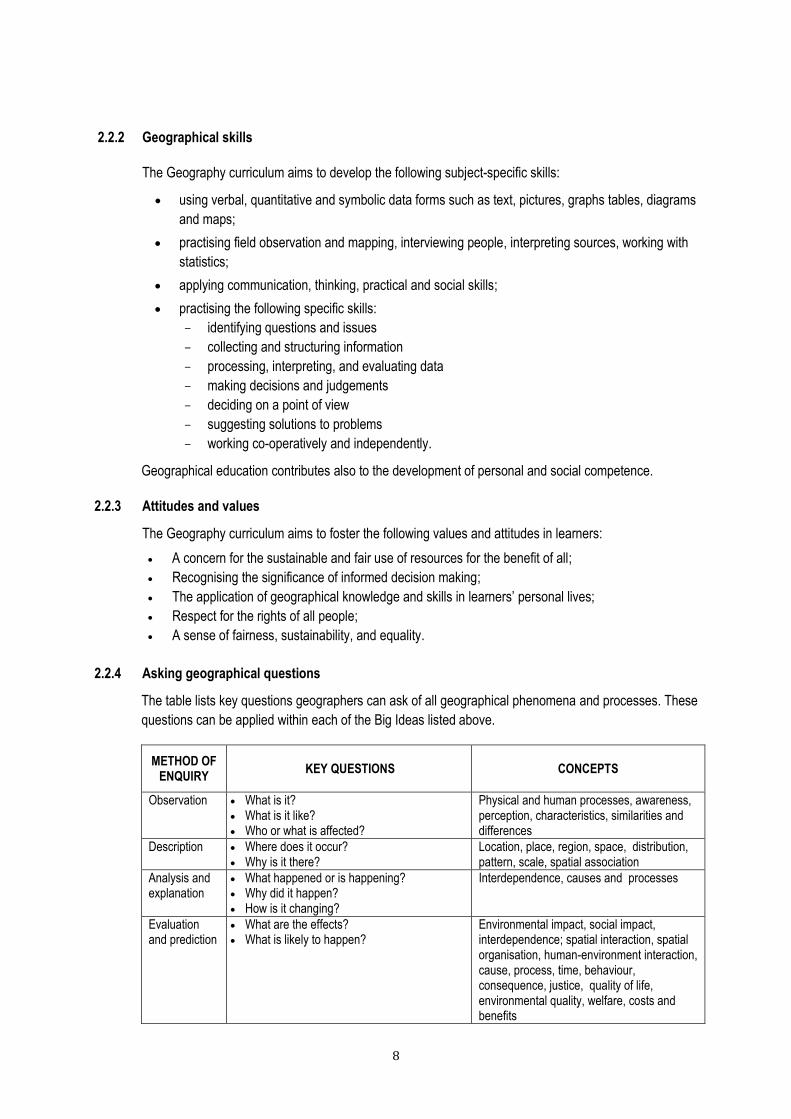
2.2.2 Geographical skills
The Geography curriculum aims to develop the following subject-specific skills:
using verbal, quantitative and symbolic data forms such as text, pictures, graphs tables, diagrams
and maps;
practising field observation and mapping, interviewing people, interpreting sources, working with
statistics;
applying communication, thinking, practical and social skills;
practising the following specific skills:
- identifying questions and issues
- collecting and structuring information
- processing, interpreting, and evaluating data
- making decisions and judgements
- deciding on a point of view
- suggesting solutions to problems
- working co-operatively and independently.
Geographical education contributes also to the development of personal and social competence.
2.2.3 Attitudes and values
The Geography curriculum aims to foster the following values and attitudes in learners:
A concern for the sustainable and fair use of resources for the benefit of all;
Recognising the significance of informed decision making;
The application of geographical knowledge and skills in learners‟ personal lives;
Respect for the rights of all people;
A sense of fairness, sustainability, and equality.
2.2.4 Asking geographical questions
The table lists key questions geographers can ask of all geographical phenomena and processes. These
questions can be applied within each of the Big Ideas listed above.
METHOD OF ENQUIRY
KEY QUESTIONS CONCEPTS
Observation What is it? What is it like? Who or what is affected?
Physical and human processes, awareness, perception, characteristics, similarities and differences
Description Where does it occur? Why is it there?
Location, place, region, space, distribution, pattern, scale, spatial association
Analysis and explanation
What happened or is happening? Why did it happen? How is it changing?
Interdependence, causes and processes
Evaluation and prediction
What are the effects? What is likely to happen?
Environmental impact, social impact, interdependence; spatial interaction, spatial organisation, human-environment interaction, cause, process, time, behaviour, consequence, justice, quality of life, environmental quality, welfare, costs and benefits

9
Decision-making
Who benefits? What decisions must be made? What are the costs and benefits of decisions? How should it be managed?
Choices, decisions, costs and benefits, planning, management, power, inequality, problem-solving
Personal evaluation, judgement and response
What is my position? What action can I take?
Cultural sensitivity, diversity, ethics, opinion forming, empathy, values, action, personal responsibility
2.3 Time allocation and weighting of topics
Geography is allocated four hours of teaching time per week. Revision, consolidation and assessment
(formal and informal) are included in this time allocation.
TERM Teaching time in weeks Teaching time in hours
1, 2 and 3 respectively 9 weeks 36 hours
Term 4
(Grades 10 and 11) 6 weeks 24 hours
Four Geography topics are to be studied in each year of the FET Band. Geographical skills and
techniques should be integrated with these topics throughout the year.
Each of the sub-topics, in the tables that follow, has been allocated a certain number of teaching hours.
The time is merely a guide. It does, however, illustrate the weighting for each sub-topic in the context
of the term‟s work.
Six hours of extra-mural fieldwork is recommended in Grade 10 and 11. Grade 12 learners should also
do some fieldwork if time allows. Because of time and logistical constraints, much of the fieldwork will
need to be conducted outside lesson time. Provision has also been made for two hours of assessment,
consolidation and revision per term. During this time tests may be conducted.
10
2.4 CONTINUITY AND PROGRESSION IN THE GEOGRAPHY CURRICULUM: Grade 4 to 12
Ban
d/P
h
ase
Gra
de
Geog. skills and
techniques
Physical Geography Human Geography
Climatology Geomorphology Environmental
Geography Population Geography
Settlement Geography
Economic Geography
GE
T:
Inte
rmed
iate
Ph
ase 4 Map skills
Water in South Africa
Places where people live
Food and farming in South Africa
5 Map skills Focus: Africa
Weather, climate and vegetation of South Africa
Physical features of South Africa
Minerals and mining in South Africa
6 Map skills Focus: World
Climate and vegetation around the world
Population: why people live where they do (SA & world)
Trade (SA and the World)
GE
T:
Sen
ior
Ph
ase
7 Map skills Focus: Local
Earthquakes, volcanoes and floods
Natural resources and conservation in South Africa
Population growth and change (World)
8
Maps and Globes Focus: Global & local
Climate Regions (SA & World)
Settlement (Africa with focus on SA)
Transport and trade (SA and World)
9
Map skills Topographical & Orthophoto maps
Surface forces that shape the Earth
Resource use and sustainability (World)
Development issues (SA and World)
FE
T
10
Map skills; Topographical maps; Aerial photographs and orthophoto maps; GIS; Using atlases; Fieldwork
The atmosphere
Composition and structure; Heating of the atmosphere; Moisture in the atmosphere; reading & interpreting synoptic maps
Geomorphology
The structure of the Earth; Plate tectonics;
Folding and faulting;
Earthquakes;
Volcanoes
Water resources
Water in the world; The world‟s oceans; Water management in South Africa; Floods
Population
Population distribution and density; Population structure; Population growth; Population movements; HIV and AIDS
11
Map skills; Topographical maps; Aerial photographs and orthophoto maps; GIS; Using atlases; Fieldwork
The atmosphere & hydrosphere
The Earth‟s energy balance; Global air circulation; Africa‟s weather and climate;
Drought and desertification;
Reading and interpreting synoptic weather maps
Geomorphology
Topography associated with horizontally layered rocks; with inclined/tilted rock strata; with massive igneous rocks; Slopes; Mass movements and human responses
Resources and sustainability
Using resources; Soil and soil erosion; Conventional energy sources & impact on the environment; Non-conventional energy sources; Energy management in South Africa
Development Geography
The concept of development; Frameworks for development; Trade and development; Development issues and challenges; Role of development aid
12
Map skills; Topographical maps; Aerial photographs and orthophoto maps; GIS; Using atlases; Fieldwork
Climate and weather
Mid-latitude cyclones;
Tropical cyclones;
Subtropical anticyclones;
Valley and urban climates; Reading and interpreting synoptic weather maps
Geomorphology
Drainage systems in South Africa; Fluvial processes; Catchment and river management
Rural Settlement
Study of settlements; Rural settlements; Rural settlement issues
Urban Settlement
Urban settlements; Urban hierarchies; Urban structure and patterns; Urban settlement issues
Economic Geography of South Africa
Structure of the economy; Agriculture; Mining; Secondary and tertiary sectors; Strategies for industrial development; Informal sector

11
2.5 OVERVIEW OF GEOGRAPHY CONTENT IN THE FET BAND
Term Grade 10 Grade 11 Grade 12
1
The atmosphere
Composition and structure of the atmosphere
Heating of the atmosphere
Moisture in the atmosphere
Reading and interpreting synoptic weather maps
Geographical skills & techniques
Using atlases
Fieldwork and practical work
The atmosphere and hydrosphere
The Earth‟s energy balance
Global air circulation
Africa‟s weather and climate
Drought and desertification
Reading and interpreting synoptic weather maps
Geographical skills & techniques
Aerial photographs and orthophoto maps
Climate and weather
Mid-latitude cyclones
Tropical cyclones
Subtropical anticyclones
Valley climates
Urban climates
Reading and interpreting synoptic weather maps
Geomorphology
Drainage systems in South Africa
Fluvial processes
Catchment and river management Geographical skills & techniques
Mapwork techniques
Atlas work
Geographical Information Systems
2
Geomorphology
The structure of the Earth
Plate tectonics
Folding and faulting
Earthquakes
Volcanoes Geographical skills & techniques
Using atlases
Mapwork skills
1:50 000 topographic maps
Geomorphology
Topography associated with horizontally layered rocks
Topography associated with inclined/tilted rock strata
Topography associated with massive igneous rocks
Slopes
Mass movements and human responses
Geographical skills & techniques
Map techniques
Fieldwork
Rural Settlement
Study of settlements
Rural settlements
Rural settlement issues
Urban Settlement
Urban settlements
Urban hierarchies
Urban structure and patterns
Urban settlement issues
Geographical skills & techniques
Geographical Information Systems
Mapwork techniques
3
Population
Population distribution and density
Population structure
Population growth
Population movements
HIV and AIDS Geographical skills & techniques
Using atlases
Development Geography
The concept of development
Frameworks for development
Trade and development
Development issues and challenges
Role of development aid Geographical skills & techniques
Mapwork skills
Using atlases
Economic Geography of SA
Structure of the economy
Agriculture
Mining
Secondary and tertiary sectors
Strategies for industrial development
Informal sector
Geographical skills & techniques
Map use and map skills; Mapwork techniques; GIS
4
Water resources
Water in the world
The world‟s oceans
Water management in South Africa
Floods
Geographical skills & techniques
Using atlases
Geographical Information Systems (GIS)
Resources and sustainability
Using resources
Soil and soil erosion
Conventional energy sources and their impact on the environment
Non-conventional energy sources
Energy management in South Africa Geographical skills & techniques
Geographical information systems
Revision
Climate and weather
Geomorphology
Settlement Geography
Economic Geography of SA
Geographical skills & techniques

12
2.6 OVERVIEW OF GEOGRAPHICAL SKILLS AND TECHNIQUES IN GRADES 10, 11 and 12
Geographical skills and techniques should be practiced in every term of the FET Band. The table below
illustrates skills and techniques across the FET Band. However, the teaching of geographical skills and
techniques should be spread across all four terms and linked to specific topics in each grade.
Grade 10 Grade 11 Grade 12
Mapwork skills
Locating exact position – degrees,
minutes and seconds
Scale – word, ratio, and line scale
Direction – true and magnetic
bearing
Mapwork skills
Locating exact position – degrees,
minutes and seconds (revision)
Relative position – direction and
magnetic bearing (revision)
Distance – measuring distances and
converting to ground distance, straight
line and curved (practise)
Calculating area
Mapwork skills
Consolidation of map skills from Grades
10, 11 and 12
Map and photo interpretation – includes
reading and analysis of physical and
constructed features
Applying map-reading skills to maps and
photos
Topographic maps
South African 1:50 000 map
referencing system
1: 50 000 maps - conventional signs
and symbols (revision)
Navigating position using compass
directions (16 points)
Direction and true bearing
Landforms and contours
Simple cross-sections
Topographic maps
Contours and landforms
Cross-sections on 1:50 000 maps
Vertical exaggeration
Intervisibility
Gradient
Topographic maps
Applying map skills and techniques -
scale, contours, cross-sections,
intervisibility
Direction - magnetic north, true north and
magnetic declination
Gradient
Grid referencing
Aerial photographs and orthophoto
maps
Photographs of landscapes
Oblique and vertical aerial photos
Orthophoto maps to be used in
conjunction with 1:50 000 maps and
aerial photos
Aerial photographs and orthophoto
maps
Oblique and vertical aerial photographs
– identifying landforms and features
Use of tone, texture, shadow in the
interpretation of photos
Orthophoto maps – identifying features
Orienting aerial photographs and
orthophoto maps with another map
Aerial photographs and orthophoto maps
Interpreting vertical aerial photographs
Orthophoto maps – identifying features
Comparing orthophoto map with a
topographic map
Geographical Information Systems
Reasons for the development of GIS
How remote sensing works
GIS concepts: spatial objects, lines,
points, nodes, scales
Geographical Information Systems
Spatially referenced data
Spatial and spectral resolution
Different types of data - line, point,
area, attribute
Raster and vector data
Application of GIS to all relevant topics
in the grade
Capturing different types of data from
existing maps, photographs, fieldwork
or other records on tracing paper
Geographical Information Systems
GIS concepts - remote sensing,
resolution
Spatial and attribute data; vector and
raster data
Data standardisation, data sharing and
data security
Data manipulation - data integration,
buffering, querying & statistical analysis
Application of GIS by government and
the private sector
Relate to all topics in Grade 12
Develop a “paper GIS” from existing
maps, photographs or other records on
layers of tracing paper

13
Using atlases
Map reading - comparing information
from different maps
Atlas index - locating physical and
constructed features
Concept of map projections: equal
area and true direction projections –
examples, limitations and values
Four-digit grid reference (latitude and
longitude, degrees and minutes) for
identifying and locating features on
maps
Using atlases (revision)
Using the index
Locating places on different maps -
degrees and minutes
Comparing information from different
maps
Using atlases (revision)
Examining thematic maps
Comparing information from different
maps
Fieldwork
Using maps and other graphical
representations - atlases, synoptic
weather maps, temperature graphs
Collecting and recording data using a
variety of techniques – using weather
instruments, collecting weather
information from the media
Processing, collating, interpreting and
presenting fieldwork findings – line
graphs, bar graphs, maps, diagrams,
synoptic weather maps
Fieldwork
Observation
Collecting and recording data
Processing, collating and presenting
fieldwork findings
Fieldwork (time permitting)
Collecting and recording data using a
variety of techniques
Processing, collating and presenting
fieldwork findings

14
SECTION 3
GEOGRAPHY in Grade 10
Geographical skills and techniques
Mapwork skills
Topographic maps
Aerial photos and orthophoto maps
Geographical Information Systems (GIS)
Using atlases
Fieldwork The atmosphere
Composition and structure of the atmosphere
Heating of the atmosphere
Moisture in the atmosphere
Reading and interpreting synoptic weather maps
Geomorphology
The structure of the Earth
Plate tectonics
Folding and faulting
Earthquakes
Volcanoes
Population
Population distribution and density
Population structure
Population growth
Population movements
HIV and AIDS
Water resources
Water in the world
The world‟s oceans
Water management in South Africa
Floods

15
Grade 10 FET Band Term 1-4
Topic:
GEOGRAPHICAL SKILLS
AND TECHNIQUES
Note: a suggested breakdown
of when these skills could be
applied appears at the end of
each topic.
Time:
± 24 hours
Total time to be spread across
the four terms
Additional resources:
Atlases
Orthophoto maps
Aerial photographs
GIS images
Topographic maps
Basic weather instruments, e.g. thermometer, rain
gauge
Mapwork skills [2 hours]
Locating exact position – degrees, minutes and seconds.
Scale – word, ratio, fraction and line scale.
Topographic maps [6 hours]
South African 1:50 000 map referencing system.
1: 50 000 maps - conventional signs and symbols.
Navigating position using compass directions (16 points).
Direction - true and magnetic bearing.
Landforms and contours.
Simple cross-sections.
Aerial photographs and orthophoto maps [4 hours]
Photographs of landscapes
Oblique and vertical aerial photos
Orthophoto maps to be used in conjunction with 1:50 000 maps and aerial photos
Geographical Information Systems (GIS) [4 hours]
Reasons for the development of GIS
How remote sensing works.
GIS concepts: spatial objects, lines, points, nodes, scales.
Using atlases [4 hours]
Kinds of maps in an atlas
- thematic maps – world climate and vegetation regions, seasonal temperature and rainfall maps
of South Africa,
- comparing different thematic maps, cross-referencing patterns.
Concept of map projections: equal area and true direction projections – examples, limitations and values.
Map reading and interpretation
Map reading - comparing information from different maps.
Interpreting graphs, population pyramids, photographs, models.
Atlas index - locating physical and constructed features.
Four-digit grid reference (latitude and longitude, degrees and minutes) to identify and locate
features on maps.
Fieldwork and practical work [4 hours]
Collecting and recording data using a variety of techniques – using weather instruments,
collecting weather information from the media.
Processing, collating and presenting fieldwork findings – line graphs, bar graphs, maps diagrams,
synoptic weather maps.

16
Using maps and other graphical representations - atlases, synoptic weather maps, temperature graphs.
Grade 10 FET Band Term 1
Topic:
THE ATMOSPHERE
Time:
± 36 hours
(includes consolidation, revision
as well as formal and informal
assessment)
Additional resources:
Atlases
Websites like http://www.weathersa.co.za
Weather measuring instruments
Synoptic weather maps and satellite images
Weather reports from the media
Selected DVDs, e.g. An Inconvenient Truth
GEOGRAPHICAL KNOWLEDGE
Composition and structure of the atmosphere [5 hours]
Importance of the atmosphere
The composition and structure of the atmosphere – troposphere, stratosphere, mesosphere,
thermosphere
The ozone layer – in the stratosphere
Causes and effects of ozone depletion
Ways to reduce ozone depletion.
Heating of the atmosphere [8 hours]
Processes associated with the heating of the atmosphere – insolation, reflection, scattering,
absorption, radiation, conduction, convection.
The Greenhouse Effect – impact on people and the environment.
Factors that affect the temperature of different places around the world - latitude, altitude,
ocean currents, distance from oceans.
Global warming - evidence, causes, and consequences with reference to Africa.
The impact of climate and climate change on Africa‟s environment and people - deserts, droughts,
floods, rising sea levels.
Moisture in the atmosphere [8 hours]
Water in the atmosphere in different forms – water vapour, liquid, ice.
Processes associated with evaporation, condensation and precipitation.
The concepts of dew point, condensation level, humidity, relative humidity - factors affecting
relative humidity.
How and why clouds form.
Cloud names and associated weather conditions.
Different forms of precipitation – hail, snow, rain, dew, frost.
Mechanisms that produce different kinds of rainfall – relief, convectional, frontal.
Reading and interpreting synoptic weather maps [6 hours]
Weather elements – temperature, dew-point temperature, cloud cover, wind direction,
wind speed, atmospheric pressure
(Note: the concept of atmospheric pressure is only introduced here; it is developed more fully
in Grade 11).

17
Weather conditions – e.g. rain, drizzle, thunderstorms, hail, snow as illustrated on station models.
Reading and interpreting a selection of synoptic weather maps.
GEOGRAPHICAL SKILLS AND TECHNIQUES (applied to above topics)
Geographical Information Systems (GIS) [1 hour]
Reasons for the development of GIS
How remote sensing works
Satellite images related to meteorology and climatology
Fieldwork and practical work [4 hours]
Using maps and other graphical representations - atlases, synoptic weather maps,
temperature graphs.
Collecting and recording data using a variety of techniques – using weather instruments,
collecting weather information from the media.
Processing, collating and presenting fieldwork findings – line graphs, bar graphs, maps,
diagrams, synoptic weather maps.
Using atlases [1 hour]
Map reading - comparing information from different maps
Atlas index - locating physical and constructed features
Assessment and consolidation [3 hours]

18
Grade 10 FET Band Term 2
Topic:
GEOMORPHOLOGY
Time:
± 36 hours
(includes consolidation,
revision as well as formal and
informal assessment)
Additional resources:
Atlases
Fieldwork
http://www.iris.edu/seismon/bigmap/index.phtml
Media information
GEOGRAPHICAL KNOWLEDGE
The structure of the Earth [6 hours]
The internal structure of the Earth.
Classification of rocks – igneous, sedimentary, metamorphic.
The rock cycle.
Intrusive igneous activity and associated features – batholiths, laccoliths, monoliths,
dykes, sills, pipes.
Overview of landforms associated with igneous, sedimentary, metamorphic rocks.
Plate tectonics [6 hours]
Changes in the position of continents over time.
Evidence for the movement of continents over time.
Plate tectonics – an explanation for the movement of continents.
The mechanics of plate movements.
Processes and landforms associated with different kinds of plate boundaries.
The world‟s volcanic and earthquake zones.
Folding and faulting [4 hours]
The process of rock folding - link to plate movement.
Landforms associated with folding.
The process of faulting – link to plate movement.
Different types of faults.
Landforms associated with faulting, e.g. rift valleys and block mountains.
Earthquakes [4 hours]
How and where earthquakes occur.
The relationship between earthquakes and tectonic forces.
Measuring and predicting earthquakes.
How earthquakes and tsunamis affect people and settlements - differences in vulnerability.
Strategies to reduce the impact of earthquakes.
Case examples of the effects of selected earthquakes.
Volcanoes [4 hours]
Types of volcanoes – extrusive, intrusive, active, dormant, extinct.
Structure of volcanoes.
Impact of volcanoes on people and the environment – positive and negative.
Case studies of different volcanic eruptions.

19
GEOGRAPHICAL SKILLS AND TECHNIQUES (applied to above topics)
Mapwork skills [2 hours]
Locating exact position – degrees, minutes and seconds.
Scale – word, ratio, fraction and line scale.
Topographic maps [4 hours]
South African 1:50 000 map referencing system.
1: 50 000 maps - conventional signs and symbols.
Navigating position using compass directions (16 points).
Direction - true and magnetic bearing.
Landforms and contours.
Simple cross-sections.
Aerial photographs and orthophoto maps [2 hours]
Photographs of landscapes
Oblique and vertical aerial photos
Orthophoto maps to be used in conjunction with 1:50 000 maps and aerial photos
Using atlases [2 hours]
Atlas index - locating physical and constructed features.
Four-digit grid reference (latitude and longitude, degrees and minutes) to identify and
locate features on maps.
Concept of map projections: examples of equal area and true direction projections –
critical evaluation
Assessment and consolidation [2 hours]
20
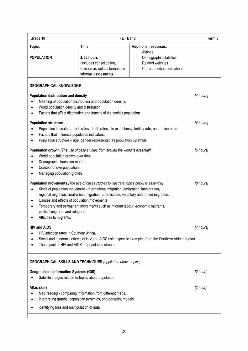
Grade 10 FET Band Term 3
Topic:
POPULATION
Time:
± 36 hours
(includes consolidation,
revision as well as formal and
informal assessment)
Additional resources:
Atlases
Demographic statistics
Related websites
Current media information
GEOGRAPHICAL KNOWLEDGE
Population distribution and density [4 hours]
Meaning of population distribution and population density.
World population density and distribution.
Factors that affect distribution and density of the world‟s population.
Population structure [4 hours]
Population indicators - birth rates, death rates, life expectancy, fertility rate, natural increase.
Factors that influence population indicators.
Population structure – age, gender represented as population pyramids.
Population growth [The use of case studies from around the world is essential] [6 hours]
World population growth over time.
Demographic transition model.
Concept of overpopulation.
Managing population growth.
Population movements [The use of cases studies to illustrate topics below is essential] [8 hours]
Kinds of population movement - international migration, emigration, immigration,
regional migration, rural-urban migration, urbanisation, voluntary and forced migration.
Causes and effects of population movements
Temporary and permanent movements such as migrant labour, economic migrants,
political migrants and refugees.
Attitudes to migrants.
HIV and AIDS [4 hours]
HIV infection rates in Southern Africa.
Social and economic effects of HIV and AIDS using specific examples from the Southern African region.
The impact of HIV and AIDS on population structure.
GEOGRAPHICAL SKILLS AND TECHNIQUES (applied to above topics)
Geographical Information Systems (GIS) [2 hour]
Satellite images related to topics about population
Atlas skills [2 hour]
Map reading - comparing information from different maps.
Interpreting graphs, population pyramids, photographs, models.
identifying bias and manipulation of data

21
Assessment and consolidation [6 hours]
Grade 10 FET Band Term 4
Topic :
WATER RESOURCES
(The world and South
Africa)
Time:
± 24 hours
(includes consolidation,
revision as well as formal
and informal assessment)
Additional resources:
Atlases
Media information
Websites: World water at
http://www.worldwater.org/data.html and the
Department of Water Affairs http://www.dwa.gov.za/
GEOGRAPHICAL KNOWLEDGE
Water in the world [2 hours]
Different forms of water in the world – liquid, solid, gas
Occurrence of salt water and fresh water – oceans, rivers, lakes, ground water, atmosphere
The hydrological cycle
The world’s oceans [4 hours]
Oceans as sources of oxygen, food, energy
Ocean circulation – warm and cold currents
Ocean currents and their importance for fishing, trade and tourism
Relationship between oceans and people - pollution, overfishing, desalination
Strategies for managing the world‟s oceans
Water management in South Africa [5 hours]
Rivers, lakes and dams in South Africa
Factors influencing the availability of water in South Africa
Challenges of providing free basic water to rural and urban communities in South Africa
Role of government – initiatives towards securing water - interbasin transfers; building dams
Role of municipalities – provision, water purification
Strategies towards sustainable use of water – role of government and individuals
Floods [4 hours]
Causes of flooding – physical and human
Characteristics of floods: analysis and interpretation of flood hydrographs
Managing flooding in urban, rural and informal settlement areas
Case study of a flood in South Africa
GEOGRAPHICAL SKILLS AND TECHNIQUES (applied to above topics)
Topographic maps [2 hours]
Landforms and contours.
Aerial photographs and orthophoto maps [2 hours]
Photographs of landscapes
Oblique and vertical aerial photos
Orthophoto maps to be used in conjunction with 1:50 000 maps and aerial photos
Geographical Information Systems (GIS) [2 hours]
GIS concepts: spatial objects, lines, points, nodes, scales.

22
Assessment and consolidation [3 hours]

23
GEOGRAPHY in Grade 11
Geographical skills and techniques
Mapwork skills
Topographic maps
Aerial photos and orthophoto maps
Geographical Information Systems (GIS)
Using atlases
Fieldwork The atmosphere and hydrosphere
The Earth‟s energy balance
Global air circulation
Africa‟s weather and climate
Drought and desertification Geomorphology
Topography associated horizontal and inclined strata
Topography associated with massive igneous rocks
Slopes
Mass movements and human responses Development Geography
The concept of development
Frameworks for development
Trade and development
Development issues and challenges
Role of development aid Resources and sustainability
Using resources
Soil and soil erosion
Conventional energy sources and their impact on the environment
Non-conventional energy sources
Energy management in South Africa
24
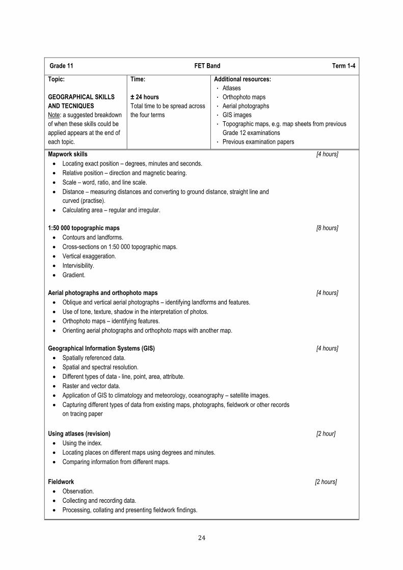
Grade 11 FET Band Term 1-4
Topic:
GEOGRAPHICAL SKILLS
AND TECNIQUES
Note: a suggested breakdown
of when these skills could be
applied appears at the end of
each topic.
Time:
± 24 hours
Total time to be spread across
the four terms
Additional resources:
Atlases
Orthophoto maps
Aerial photographs
GIS images
Topographic maps, e.g. map sheets from previous
Grade 12 examinations
Previous examination papers
Mapwork skills [4 hours]
Locating exact position – degrees, minutes and seconds.
Relative position – direction and magnetic bearing.
Scale – word, ratio, and line scale.
Distance – measuring distances and converting to ground distance, straight line and
curved (practise).
Calculating area – regular and irregular.
1:50 000 topographic maps [8 hours]
Contours and landforms.
Cross-sections on 1:50 000 topographic maps.
Vertical exaggeration.
Intervisibility.
Gradient.
Aerial photographs and orthophoto maps [4 hours]
Oblique and vertical aerial photographs – identifying landforms and features.
Use of tone, texture, shadow in the interpretation of photos.
Orthophoto maps – identifying features.
Orienting aerial photographs and orthophoto maps with another map.
Geographical Information Systems (GIS) [4 hours]
Spatially referenced data.
Spatial and spectral resolution.
Different types of data - line, point, area, attribute.
Raster and vector data.
Application of GIS to climatology and meteorology, oceanography – satellite images.
Capturing different types of data from existing maps, photographs, fieldwork or other records
on tracing paper
Using atlases (revision) [2 hour]
Using the index.
Locating places on different maps using degrees and minutes.
Comparing information from different maps.
Fieldwork [2 hours]
Observation.
Collecting and recording data.
Processing, collating and presenting fieldwork findings.

25
Grade 11 FET Band Term 1
Topic:
THE ATMOSPHERE AND
HYDROSPHERE
Time:
± 36 hours
(includes consolidation,
revision as well as formal and
informal assessment)
Additional resources:
Atlases
Relevant DVDs
Media information
GEOGRAPHICAL KNOWLEDGE
The Earth’s energy balance [4 hours]
The unequal heating of the atmosphere – latitudinal and seasonal.
Significance of Earth‟s axis and revolution around the Sun.
Transfer of energy and energy balance - role of ocean currents and winds.
Global air circulation [8 hours]
Global air circulation – a response to the unequal heating of the atmosphere.
World pressure belts
Tri-cellular circulation - Hadley, Ferrel, Polar cells.
The relationships between air temperature, air pressure and wind.
Pressure gradient, Coriolis force and geostrophic flow.
Winds related to global air circulation – westerlies, tropical easterlies, polar easterlies.
Air mass characteristics
Winds related to regional and local air movements – Monsoons, Föhn
Africa’s weather and climate [8 hours]
Africa‟s climate regions.
Subsidence and convergence – link to rainfall.
The role of oceans in climate control in Africa.
El Niño and La Niña processes and their effects on Africa‟s climate.
Reading and interpreting synoptic weather maps
Droughts and desertification [8 hours]
Areas at risk: regional and local scales.
Causes of droughts
Causes of desertification
Effects of droughts and desertification on people and the environment, e.g. differences
in vulnerability.
Management strategies – case studies.

26
GEOGRAPHICAL SKILLS AND TECHNIQUES (applied to above topics)
Aerial photographs and orthophoto maps [4 hours]
Oblique and vertical aerial photographs – identifying landforms and features.
Use of tone, texture, shadow in the interpretation of photos.
Orthophoto maps – identifying features.
Orienting aerial photographs and orthophoto maps with another map.
Geographical and Information Systems (GIS) [2 hours]
Satellite images
Application of GIS to climatology and meteorology
Assessment and consolidation [2 hours]

27
Grade 11 FET Band Term 2
Topic:
GEOMORPHOLOGY
Time:
± 36 hours
(includes consolidation,
revision as well as formal and
informal assessment)
Additional resources:
Atlases
Topographical and orthophoto maps
(Colour) pictures in printed media
Related DVDs or videos
GEOGRAPHICAL KNOWLEDGE
Topography associated with horizontally layered rocks: [4 hours]
Characteristics and processes associated with the development of: hilly landscapes,
basaltic plateaus, canyon landscapes, Karoo landscapes (mesa, butte, conical hill);
Concept of scarp retreat / back wasting;
Utilisation of these landscapes by humans.
Topography associated with inclined/tilted rock strata: [4 hours]
Characteristics and processes associated with the development of: a scarp slope, a dip slope,
a cuesta, homoclinal ridge, hogsback, cuesta basin, cuesta dome;
Utilisation of these landscapes by humans.
Topography associated with massive igneous rocks: [4 hours]
Identification of batholiths, laccoliths, lopoliths, dykes and sills;
Characteristics and processes associated with the development of granite domes and tors.
Slopes [4 hours]
Overview of South Africa‟s topography.
Types of slopes.
Slope elements - crest, cliff (scarp slope, free face); talus (debris, scree slope); pediment.
Characteristics of the slope elements - crest, cliff, talus, pediment.
Slope development over time.
The concept of slope retreat.
Mass movements and human responses [4 hours]
Concept of mass movements.
Kinds of mass movements - soil creep, solifluction, landslides, rock falls and mud flows, slumps.
The impact of mass movements on people and the environment.
Strategies to prevent or minimise the effects of mass movement - case studies from South Africa.
GEOGRAPHICAL SKILLS AND TECHNIQUES (applied to above topics)
Topographic maps [6 hours]
Contours and landforms.
Cross-sections on 1:50 000 topographic maps.
Vertical exaggeration.
Intervisibility.
Gradient.

28
Geographical Information Systems (GIS) [2 hours]
Spatially referenced data.
Spatial and spectral resolution.
Different types of data - line, point, area, attribute.
Raster and vector data.
Capturing different types of data from existing maps, photographs, fieldwork or other records
on tracing paper
Fieldwork [2 hours]
Observation.
Collecting and recording data.
Processing, collating and presenting fieldwork findings.
Assessment and consolidation [6 hours]

29
Grade 11 FET Band Term 3
Topic:
DEVELOPMENT
GEOGRAPHY
Time:
± 36 hours
(includes consolidation,
revision as well as formal and
informal assessment)
Additional resources:
Atlases
Media information
Current statistical data
www.statssa.gov.za/
GEOGRAPHICAL KNOWLEDGE
The concept of development [7 hours]
Terminology associated with development, e.g. developed, developing, more economically
developed countries (MEDCs) and less economically developed countries (LEDCs),
industrialised countries.
The concept of development: including: economic, social, sustainable, appropriate - scale and
spatial aspects
Economic, social and demographic indicators of development, such as: GNP, GDP, HDI,
Gini-coefficient, life expectancy, infant mortality.
Examples to illustrate differences in development from local, regional, and global contexts.
Frameworks for development [6 hours]
Factors affecting development - including: access to resources, energy, history,
trade imbalances, population growth, education and training, natural resource limitations
and environmental degradation.
Note: learners need to explore the complexity and inter-related nature of these factors.
Development models
- Free market models – e.g. Rostow‟s Model – its limitations and criticisms
- Core and periphery models – application at different scales
- Sustainability models – including economic, social, and environmental elements
Community based development - approaches to rural and urban development
[Examples to illustrate the above from around the world] Trade and development [6 hours]
International trade and world markets – commodities traded, terms of trade
Types of trading relationships – including: free trade, trade barriers, subsidies, fair trade.
The concept of globalisation and its impact on development
Export-led development – critically examined
[Examples from around the world] Development issues and challenges [4 hours]
The role of women in development - gender issues related to power, access to resources
and attitudes.
The effect of development on the environment.
The role of the state and business in development in South Africa, e.g. central control by
the state, weak state control, public private partnerships.
Role of development aid [4 hours]
Concept of development aid and development co-operation.
Types of development aid – technical, conditional, humanitarian.
Impact of aid on development.
[Case studies of development aid – positive and negative]

30
GEOGRAPHICAL SKILLS AND TECHNIQUES (applied to above topics)
Mapwork skills (with reference to 1:50 000 topographic maps) [4 hours]
Locating exact position – degrees, minutes and seconds.
Relative position – direction and magnetic bearing.
Scale – word, ratio, and line scale.
Distance – measuring distances and converting to ground distance, straight line
and curved (practise).
Calculating area.
Using atlases (revision) [1 hour]
Using the index.
Locating places on different maps using degrees and minutes.
Comparing information from different maps.
Assessment and consolidation [4 hours]

31
Grade 11 FET Band Term 4
Topic:
RESOURCES AND
SUSTAINABILITY
Time:
± 24 hours
(includes consolidation,
revision as well as formal and
informal assessment)
Additional resources:
Atlases
www.statssa.gov.za/
Media information
South African Yearbook
GEOGRAPHICAL KNOWLEDGE
Using resources [3 hours]
The relationship between resources and economic development
Exploitation and depletion of resources
Concepts of sustainability and sustainable use of resources
Soil and soil erosion [5 hours]
How soils are formed
Soil as a resource
Causes of soil erosion – human, animal, physical, past and present
Evidence of soil erosion in South Africa
Effects of soil erosion on people and the environment
Management strategies to prevent and control soil erosion
Conventional energy sources and their impact on the environment [5 hours]
Maps and graphs to show thermal, hydro, and nuclear energy production in South Africa
Thermal electricity generation using coal – outline of principles and processes
The impact of coal mining and thermal power stations – environmental despoliation,
solid waste, waste gases, acid rain
Case study of nuclear energy – advantages and disadvantages
South Africa‟s potential to meet long term energy needs using conventional sources
Non-conventional energy sources [4 hours]
Solar energy – examples from South Africa and the world
Wind energy – examples from South Africa and the world
Future of non-conventional energy in South Africa
Possible effects of using more non-conventional energy on the South African economy and
the environment
Energy management in South Africa [3 hours]
South Africa‟s changing energy needs
Energy management towards greener economies and sustainable life styles - responsibilities
of governments, businesses, and individuals

32
GEOGRAPHICAL SKILLS AND TECHNIQUES (applied to above topics)
Topographic maps (applications and revision) [2 hours]
Contours and landforms
Cross-sections on 1:50 000 maps
Vertical exaggeration
Intervisibility
Gradient
Geographical Information Systems (GIS) [2 hours]
Spatially referenced data.
Spatial and spectral resolution.
Different types of data - line, point, area, attribute.
Raster and vector data.
Capturing different types of data from existing maps, photographs, fieldwork or other records
on tracing paper
Assessment and consolidation [2 hours]

33
GEOGRAPHY in Grade 12
Geographical skills and techniques
Mapwork skills
Topographic maps
Aerial photos and orthophoto maps
Geographical Information Systems (GIS)
Using atlases Climate and weather
Mid-latitude cyclones
Tropical cyclones
Subtropical anticyclones
Valley climates
Urban climates
Geomorphology
Drainage systems in South Africa
Fluvial processes
Catchment and river management
Rural and urban settlement
Study of settlements
Rural settlements
Rural settlement issues
Urban settlements
Urban hierarchies
Urban structure and growth
Urban settlement issues Economic Geography of South Africa
Structure of the economy
Agriculture
Mining
Secondary and tertiary sectors
Strategies for industrial development
Informal sector
34
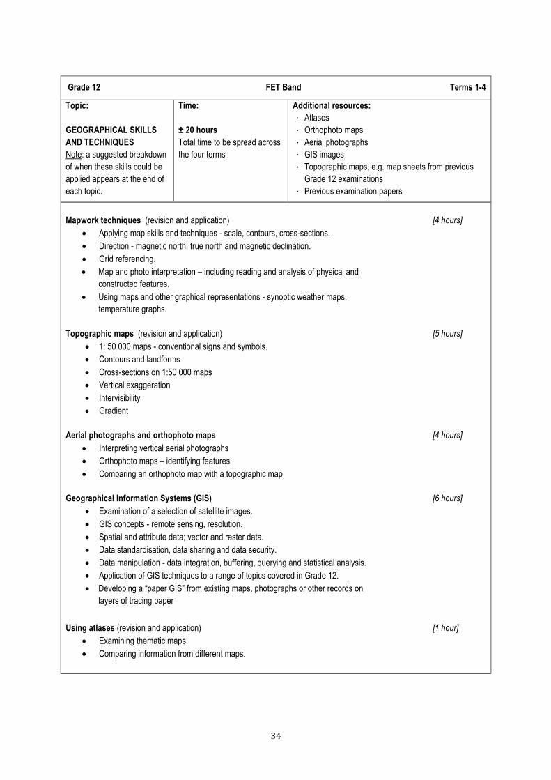
Grade 12 FET Band Terms 1-4
Topic:
GEOGRAPHICAL SKILLS
AND TECHNIQUES
Note: a suggested breakdown
of when these skills could be
applied appears at the end of
each topic.
Time:
± 20 hours
Total time to be spread across
the four terms
Additional resources:
Atlases
Orthophoto maps
Aerial photographs
GIS images
Topographic maps, e.g. map sheets from previous
Grade 12 examinations
Previous examination papers
Mapwork techniques (revision and application) [4 hours]
Applying map skills and techniques - scale, contours, cross-sections.
Direction - magnetic north, true north and magnetic declination.
Grid referencing.
Map and photo interpretation – including reading and analysis of physical and
constructed features.
Using maps and other graphical representations - synoptic weather maps,
temperature graphs.
Topographic maps (revision and application) [5 hours]
1: 50 000 maps - conventional signs and symbols.
Contours and landforms
Cross-sections on 1:50 000 maps
Vertical exaggeration
Intervisibility
Gradient
Aerial photographs and orthophoto maps [4 hours]
Interpreting vertical aerial photographs
Orthophoto maps – identifying features
Comparing an orthophoto map with a topographic map
Geographical Information Systems (GIS) [6 hours]
Examination of a selection of satellite images.
GIS concepts - remote sensing, resolution.
Spatial and attribute data; vector and raster data.
Data standardisation, data sharing and data security.
Data manipulation - data integration, buffering, querying and statistical analysis.
Application of GIS techniques to a range of topics covered in Grade 12.
Developing a “paper GIS” from existing maps, photographs or other records on
layers of tracing paper
Using atlases (revision and application) [1 hour]
Examining thematic maps.
Comparing information from different maps.

35
Grade 12 FET Band Term 1
Topic:
CLIMATE AND WEATHER
(regional and local weather
systems)
Weighting:
25% of Paper 1 (75 marks)
Time:
± 14 + 5 hours
(includes consolidation,
mapwork, revision as well as
formal and informal
assessment)
Additional resources:
Atlases; media information
http://www.weathersa.co.za for weather prediction,
satellite images and synoptic weather charts
Also http://www.weatherphotos.co.za
GEOGRAPHICAL KNOWLEDGE
Mid-latitude cyclones [3 hours]
General characteristics.
Areas where mid-latitude cyclones form.
Conditions necessary for their formation.
Stages of development and related weather conditions.
Weather patterns associated with: cold, warm, and occluded fronts.
Reading and interpreting satellite images and synoptic weather maps.
Tropical cyclones [4 hours]
General characteristics.
Areas where tropical cyclones form.
Factors necessary for their formation.
Stages of development.
Associated weather patterns.
Reading and interpreting satellite images and synoptic weather maps.
Case study of one recent tropical cyclone that affected southern Africa.
Impact of tropical cyclones on human activities and the environment.
Strategies that help to prepare for and manage the effects of tropical cyclones.
Subtropical anticyclones and associated weather conditions [3 hours]
Location of the high-pressure cells that affect South Africa.
General characteristics of these high-pressure cells.
Anticyclonic air circulation around South Africa and its influence on weather and climate
Travelling disturbances associated with anticyclonic circulation– moisture front,
line thunderstorms, coastal low pressure systems and South African berg winds
Reading and interpreting satellite images and synoptic weather maps that illustrate weather
associated with subtropical anticyclonic conditions.
Valley climates [2 hours]
The micro-climate of valleys (the effect of the slope aspect).
Development of anabatic and katabatic winds, inversions, frost pockets, radiation fog.
The influence of local climates on human activities - settlement, farming.
Urban climates [2 hours]
Reasons for differences between rural and urban climates.
Urban heat islands – causes and effects.
Concept of pollution domes – causes and effects.
Strategies to reduce the heat island effect.

36
Grade 12 FET Band Term 1
Topic:
GEOMORPHOLOGY
Weighting:
25% of Paper 1
(75 marks)
Time:
± 12 + 5 hours
(includes mapwork,
consolidation, revision, and
formal and informal
assessment)
Additional resources:
http://ga.water.usgs.gov/edu/watercycle.html
Information re SA rivers: http://www.dwaf.gov.za/
http://www.uwsp.edu/geo/faculty/ritter/geog101/
textbook/ fluvial systems/drainage_patterns.html
http://www.slideshare.net/migratorycoconut/chapter-81-
mass-movements
Rivers in local environment (fieldwork)
GIS related to catchment areas
Drainage systems in South Africa [5 hours]
Important concepts - drainage basin, catchment area, river system, watershed, tributary,
river mouth, source, confluence, water table, surface run-off, groundwater.
Types of rivers – permanent, periodic, episodic, exotic.
Drainage patterns – dendritic, trellis, rectangular, radial, centripetal, deranged, parallel.
Drainage density
Use of topographic maps to identify stream order and density.
Discharge of a river – laminar and turbulent flow.
Fluvial processes [4 hours]
River profiles - transverse profile, longitudinal profile and their relationship to different stages
of a river.
Identification and description of fluvial landforms, e.g. meanders, oxbow lakes,
braided streams, floodplain, natural leveé, waterfall, rapids, delta.
River grading.
Rejuvenation of rivers – reasons and resultant features, e.g. knick point, terraces,
incised meanders.
River capture (stream piracy) – the concepts of abstraction and river capture; features associated
with river capture (captor stream, captured stream, misfit stream, elbow of capture, wind gap)
Superimposed and antecedent drainage patterns.
Catchment and river management [3 hours]
Importance of managing drainage basins and catchment areas.
Impact of people on drainage basins and catchment areas.
Case study of one catchment area management strategy in South Africa.
GEOGRAPHICAL SKILLS AND TECHNIQUES (application to climatology and geomorphology)
Mapwork techniques [2 hours]
Map and photo interpretation – includes reading and analysis of physical and constructed features
Applying map-reading skills to maps and photos
Topographic maps [2 hours]
Contours and landforms
Cross sections
Direction - magnetic north, true north and magnetic declination
Gradient
Intervisibility
37
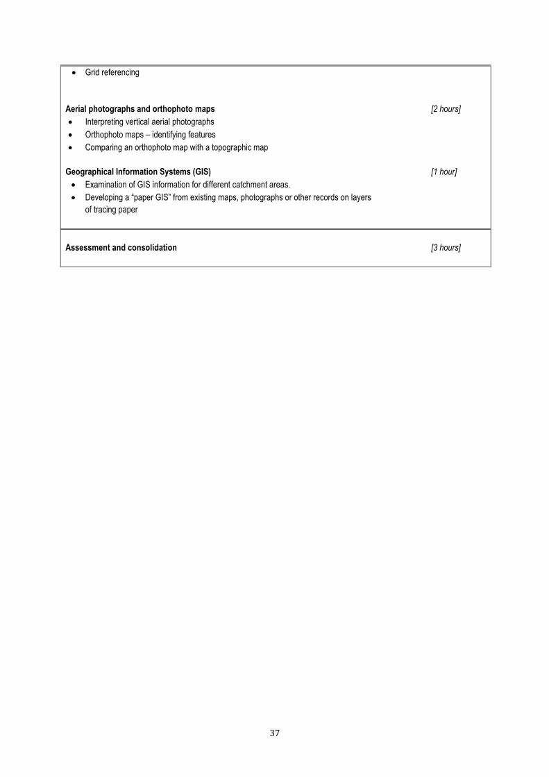
Grid referencing
Aerial photographs and orthophoto maps [2 hours]
Interpreting vertical aerial photographs
Orthophoto maps – identifying features
Comparing an orthophoto map with a topographic map
Geographical Information Systems (GIS) [1 hour]
Examination of GIS information for different catchment areas.
Developing a “paper GIS” from existing maps, photographs or other records on layers
of tracing paper
Assessment and consolidation [3 hours]

38
Grade 12 FET Band Term 2
Topic:
RURAL SETTLEMENT and
URBAN SETTLEMENT
Weighting:
25% of Paper 1
(75 marks)
Time:
± 36 hours
(includes mapwork,
consolidation, revision, and
formal and informal
assessment)
Additional resources:
Atlases; media information
http://www.statssa.gov.za/
Maps, topographical and orthophoto maps
Vertical photographs or satellite images
(e.g. Google Earth)
Telephone directory for types of economic activities
in a settlement
Study of settlements [3 hours]
Concept of settlement
Site and situation.
Rural and urban settlements.
Settlement classification according to size, complexity, pattern and function.
Rural settlements [5 hours]
How site and situation affect the location of rural settlements.
Classification of rural settlements according to pattern and function.
Reasons for different shapes of settlements - round, linear, T-shaped, cross-road.
Land use in rural settlements.
Rural settlement issues [6 hours]
Rural-urban migration
Causes and consequences of rural depopulation on people and the economy.
Case study that illustrates effects of rural depopulation and strategies to address them.
Social justice issues associated with rural areas – access to resources, land reform.
Urban settlements [4 hours]
The origin and development of urban settlements – urbanisation of the world population.
How site and situation affect the location of urban settlements.
Classification of urban settlements according to function, e.g. central places, trade and transport,
break of bulk points, specialised cities, junction towns, gateway/gap towns.
Urban hierarchies [2 hours]
The concepts of urban hierarchy, central place, threshold population, sphere of influence,
range of goods.
Lower and higher order functions and services.
Lower and higher order centres.
Urban structure and patterns [4 hours]
Internal structure and patterns of urban settlements
- land use zones
- concept of urban profile
- factors influencing the morphological structure of a city.
Models of urban structure, e.g. Multiple-nuclei model, the modern American-western city,
the Third World city and the South African city.

39
Changing urban patterns and land use in South African cities.
Urban settlement issues [5 hours]
Recent urbanisation patterns in South Africa.
Urban issues related to rapid urbanisation – lack of planning, housing shortage, overcrowding,
traffic congestion, problems with service provision.
The growth of informal settlements and associated issues - case studies from the world
and South Africa.
Case studies of how selected urban areas in South Africa are managing urban challenges –
to include environmental, economic, and social justice concerns.
GEOGRAPHICAL SKILLS AND TECHNIQUES (application to above topics)
Mapwork skills [3 hours]
Applying map skills and techniques - scale, contours, cross-sections
Map and photo interpretation – including reading and analysis of physical and
constructed features.
Geographical Information Systems (GIS) [2 hours]
GIS concepts - remote-sensing, resolution.
Spatial and attribute data; vector and raster data.
Data standardisation, data sharing and data security.
Data manipulation - data integration, buffering, querying and statistical analysis.
Application of GIS by government and the private sector.
Relate to weather and settlement topics discussed above.
Developing a “paper GIS” from existing maps, photographs or other records on
layers of tracing paper
Assessment and consolidation [2 hours]

40
Grade 12 FET Band Term 3
Topic:
ECONOMIC GEOGRAPHY OF
SOUTH AFRICA
Weighting:
25% of Paper 1 (75 marks)
Time:
± 36 hours
(includes mapwork,
consolidation, revision and
formal and informal
assessment)
Additional resources:
Atlases, topographic maps, aerial photos, media
information
Satellite images
http://www.statssa.gov.za
Food security: http://www.fanrpan.org
Information on Maputo Corridor:
http://www.mcli.co.za/mcli-web/mdc/sdi.htm
Structure of the economy [3 hours]
Economic sectors (primary, secondary, tertiary, quaternary).
Economic sectors‟ contribution to the South African economy – value, employment.
Use of statistical and graphical information.
Agriculture [5 hours]
Contribution of agriculture to the South African economy.
The role of small-scale farmers and large-scale farmers.
Main products produced – home market, export market.
Factors that favour and hinder agriculture in South Africa, e.g. climate, soil, land ownership, trade.
The importance of food security in South Africa – influencing factors.
Case studies related to food security in South Africa.
Mining [5 hours]
Contribution of mining to the South African economy
Significance of mining to the development of South Africa
Factors that favour and hinder mining in South Africa
A case study of one of South Africa‟s main minerals in relation to above points
Secondary and tertiary sectors [6 hours]
Contribution of secondary and tertiary sectors to the South African economy.
Types of industries, e.g. heavy, light, raw material orientated, market orientated,
footloose industries, ubiquitous industries, bridge industries.
Factors influencing industrial development in South Africa, e.g. raw materials, labour supply,
transport infrastructure, political intervention, competition, trade.
South Africa‟s industrial regions
- Gauteng (PWV), Durban-Pinetown, Port Elizabeth-Uitenhage, South-western Cape
- factors influencing their location
- main industrial activities.
[Case studies from South Africa to illustrate the above]
Strategies for industrial development [3 hours]
Overview of apartheid and post-apartheid industrial development strategies.
Concept and distribution of Industrial Development Zones (IDZs).
Case studies of two Special Development Initiatives (SDIs).
Issues associated with industrial centralisation and decentralisation.

41
Informal sector [4 hours]
Concept and characteristics of informal sector employment.
Reasons for high informal sector employment in South Africa.
Challenges facing South Africa‟s informal sector.
[Case studies to illustrate the above in the South African context]
GEOGRAPHICAL SKILLS AND TECHNIQUES (application to above topics)
Mapwork skills [2 hours]
Consolidation of map skills from Grades 10, 11 and 12.
Map and photo interpretation – includes reading and analysis of physical and
constructed features.
Applying map-reading skills to maps and photos.
Topographic maps [2 hours]
Applying map skills and techniques - scale, contours, cross-sections
Grid referencing
Geographical Information Systems (GIS) [2 hours]
Examination of a selection of satellite images.
GIS concepts - remote sensing, resolution.
Spatial and attribute data; vector and raster data.
Data standardisation, data sharing and data security.
Data manipulation - data integration, buffering, querying and statistical analysis.
Developing a “paper GIS” from existing maps, photographs or other records on layers
of tracing paper
Using atlases (revision) [1 hour]
Examining thematic maps
Comparing information from different maps
Assessment and consolidation [3 hours]
Grade 12 FET Band Term 4
Revision
Climate and weather. [3 hours]
Geomorphology. [3 hours]
Settlement Geography (rural and urban). [3 hours]
Economic Geography of South Africa. [3 hours]
Geographical skills and techniques. [3 hours]

42
SECTION 4
ASSESSMENT GUIDELINES
4.1 INTRODUCTION
Assessment is a continuous planned process of identifying, gathering and interpreting information about
the performance of learners, using various forms of assessment. It involves four steps: generating and
collecting evidence of achievement; evaluating this evidence; recording the findings and using this
information to understand and thereby assist the learner‟s development in order to improve the process
of learning and teaching.
Assessment is integral to teaching and learning. Assessment informs teachers about learners‟ specific
needs. It provides teachers with feedback that allows them to adjust their teaching strategies.
Assessment also provides learners with feedback, allowing them to monitor their own achievement.
Assessment that takes note of learners‟ needs is called „assessment for learning‟. Assessment for
learning is developmental. It helps learners to improve and progress by informing them of their
strengths and weaknesses. When the focus of assessment is on the results of learning, assessment is
referred to as „assessment of learning‟. Assessment of learning usually takes place at the end of a
period of work, such as a topic, term or year. Assessment of learning is typically used for promotion and
certification purposes. Both assessment for learning and assessment of learning strategies should be
used during the school year.
4.2 INFORMAL OR DAILY ASSESSMENT
Assessment for learning has the purpose of continuously collecting information on a learner‟s
achievement that can be used to improve their learning.
Informal assessment is a daily monitoring of learners‟ progress. This is done through observations,
discussions, practical demonstrations, learner-teacher conferences, informal classroom interactions, etc.
Informal assessment may be as simple as stopping during the lesson to observe learners or to discuss
with learners how learning is progressing. Informal assessment should be used to provide feedback to
the learners and to inform planning for teaching, but need not be recorded. It should not be seen as
separate from learning activities taking place in the classroom. Learners or teachers can mark these
assessment tasks.
43
Self assessment and peer assessment actively involves learners in assessment. This is important as it
allows learners to learn from and reflect on their own performance. The results of the informal daily
assessment tasks are not formally recorded unless the teacher wishes to do so. The results of daily
assessment tasks are not taken into account for promotion and certification purposes.
4.3 FORMAL ASSESSMENT
All assessment tasks that make up a formal programme of assessment for the year are regarded as
Formal Assessment. Formal assessment tasks are marked and formally recorded by the teacher for
progression and certification purposes. All Formal Assessment tasks are subject to moderation for the
purpose of quality assurance and to ensure that appropriate standards are maintained.
Formal assessment provides teachers with a systematic way of evaluating how well learners are
progressing in a grade and in a particular subject. Examples of formal assessments include tests,
examinations, practical tasks, projects, oral presentations, demonstrations, performances, etc. Formal
assessment tasks form part of a year-long formal Programme of Assessment in each grade and subject.
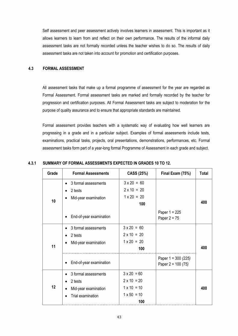
4.3.1 SUMMARY OF FORMAL ASSESSMENTS EXPECTED IN GRADES 10 TO 12.
Grade Formal Assessments CASS (25%) Final Exam (75%) Total
10
3 formal assessments
2 tests
Mid-year examination
3 x 20 = 60
2 x 10 = 20
1 x 20 = 20
100
400
End-of-year examination Paper 1 = 225
Paper 2 = 75
11
3 formal assessments
2 tests
Mid-year examination
3 x 20 = 60
2 x 10 = 20
1 x 20 = 20
100
400
End-of-year examination Paper 1 = 300 (225)
Paper 2 = 100 (75)
12
3 formal assessments
2 tests
Mid-year examination
Trial examination
3 x 20 = 60
2 x 10 = 20
1 x 10 = 10
1 x 50 = 10
100
400

44
External examination Paper 1 = 300 (225)
Paper 2 = 100 (75)
4.3.2 FORMAL ASSESSMENT REQUIREMENTS FOR GEOGRAPHY
Formal assessment in each year of the FET band comprises: three formal assessment tasks, two tests, and two examinations. Grade 12 has the added external examination.
a) Tasks
Tasks should cover the geographical content and concepts highlighted in the curriculum. They should include a variety of activities and strategies that assess specific aims and skills. Some examples of formal assessment strategies are listed below. These assessment strategies may form the focus of specific tasks or they may be used together as part of a task.
Reading and interpreting maps
Drawing graphs
Labelling diagrams
Working with data and doing calculations
Analysing photographs and satellite images
Conducting and writing up research
Writing paragraphs and essays
Analysing and synthesising information from different sources
Evaluating arguments and expressing and supporting a point of view
b) Tests and Examinations
Tests and examinations for formal assessment should cover a substantial amount of content.
A test should be between 40 and 60 minutes long. A test needs to cover a significant amount of content and skills, e.g. a section of work that covers about four to six weeks. Tests may include a variety of assessment styles such as: multiple choice questions, one line answers, written paragraphs, labeling diagrams, doing calculations, working with data.
Tests and exams must be completed under strictly controlled conditions.
Tests and examinations must cater for a range of cognitive levels. The following is the suggested weighting across the different grades in the FET band:
GRADE
Lower order
(Knowledge/ Remembering)
Middle order
(Understanding, Applying)
Higher order
(Analysing, Evaluating, Creating)
10 40% 40% 20%
11 30% 50% 20%
12 25% 50% 25%

45
4.4 PROGRAMME OF ASSESSMENT
The Programme of Assessment is designed to spread formal assessment tasks in all subjects in a
school. In Grades 10 and 11, the year mark is derived from: tasks, tests and the mid-year examination.
For promotion purposes, the year mark is added to the end-of-year examination mark (refer to tables
below).
The total mark for each grade in FET is weighted as follows:
Year mark 25%
Fourth term examination 75%
GRADE 10
Term Curriculum Formal Assessments Marks
1-4 Geographical skills
and techniques Assessment Task 1 (Term 1) 20
1 The atmosphere Test (on first term‟s work) 10
2 Population Assessment Task 2
Mid-year examination
20
20
3 Geomorphology Test 10
4 Water resources Assessment Task 3 20
Year Mark
End-of-year examination
TOTAL ASSESSMENT
Percentage
(total assessment divided by 4)
100
300
400
100%

46
GRADE 11
Term Curriculum Formal Assessments Marks
1-4 Geographical skills and
techniques Assessment Task 1 (Term 1) 20
1 The atmosphere and
hydrosphere Test (on first term‟s work) 10
2 Geomorphology Assessment Task 2
Mid-year examination
20
20
3 Development Geography Test 10
4 Resources and sustainability Assessment Task 3 20
Year Mark
End-of-year examination
TOTAL ASSESSMENT
Percentage
(total assessment divided by 4)
100
300
400
100%
GRADE 12
Term Curriculum Formal Assessments Marks
1-4 Geographical skills and
techniques Assessment Task 1 (Term 1) 20
1 Climate and weather
Geomorphology
Test (on Climatology and weather)
Test (on Geomorphology)
10
10
2 Rural and Urban Settlement Assessment Task 2
Mid-year examination
20
10
3-4 Economic Geography of
South Africa
Assessment Task 3
Trial Examination
20
10
Year Mark
End-of year-examination
TOTAL ASSESSMENT
Percentage
(total assessment divided by 4)
100
300
400
100%

47
4.5 RECORDING AND REPORTING
Recording is a process in which the teacher documents the level of a learner‟s performance in a specific
assessment task. It indicates learner progress towards the achievement of the knowledge as prescribed
in the Curriculum and Assessment Policy Statements. Records of learner performance should provide
evidence of the learner‟s conceptual progression within a grade and her / his readiness to progress or
being promoted to the next grade. Records of learner performance should also be used to verify the
progress made by teachers and learners in the teaching and learning process.
Reporting is a process of communicating learner performance to learners, parents, schools, and other
stakeholders. Learner performance can be reported in a number of ways. These include report cards,
parents‟ meetings, school visitation days, parent-teacher conferences, phone calls, letters, class or
school newsletters, etc. Teachers in all grades report in percentages against the subject. Seven levels of
competence have been described for each subject listed for Grades R - 12. The various achievement
levels and their corresponding percentage bands are as shown in the Table below.
CODES AND PERCENTAGES FOR RECORDING AND REPORTING
RATING CODE DESCRIPTION OF COMPETENCE PERCENTAGE
7 Outstanding achievement 80 – 100
6 Meritorious achievement 70 – 79
5 Substantial achievement 60 – 69
4 Adequate achievement 50 – 59
3 Moderate achievement 40 – 49
2 Elementary achievement 30 – 39
1 Not achieved 0 - 29
Note: The seven point scale should have clear descriptors that give detailed information for each
level. Teachers will record actual marks against the task by using a record sheet; and report
percentages against the subject on the learners’ report cards.

48
4.6 MODERATION OF ASSESSMENT
Moderation refers to the process that ensures that the assessment tasks are fair, valid and reliable.
Moderation should be implemented at school, district, provincial and national levels. Comprehensive and
appropriate moderation practices must be in place for the quality assurance of all subject assessments.
In grades 10 and 11 all assessment is internal. In Grade 12 the end-of-the year assessment (75%) is
externally set, marked and moderated.
4.7 ANNEXURE
ASSESSMENT IN GEOGRAPHY - SOME POINTS TO CONSIDER
Assessment in Geography should be guided by the following:
Knowing and understanding geographically
Learners should be able to demonstrate knowledge and understanding of:
1. The wide range of physical and human processes that contribute to the development of:
physical, economic, social, political and cultural environments
spatial patterns and spatial interactions
2. The inter-relationships between people‟s activities and the total environment and an ability to seek
and offer explanations for them.
3. The importance of scale (personal, local, provincial, national, continental, global) and how spatial
distributions and working systems interact.
4. The changes that occur through time in places, landscapes and spatial distribution.
Working with data (from a variety of sources)
Learners should be able to:
5. Ask questions, observe, collect, organise (classify), analyse, synthesise (interpret) and present
geographical data.
6. Use and apply geographical skills and techniques in reading, analysing and interpreting information
and data in various forms (verbal, numerical, diagrammatic, pictorial, graphical and digital)
7. Depict information in simple map, diagrammatic and digital forms.
8. Use geographical data to recognise spatial patterns and interactions.

49
Making judgements and decisions
Learners should be able to:
9. Reason, make judgements (including evaluating and drawing conclusions) that demonstrate, where
appropriate:
sensitivity to, and a concern for, the environment and the need for sustainable
development;
a an aesthetic appreciation of the Earth including its people, their activities, places,
landscapes, natural processes and phenomena;
an appreciation of the attitudes, values, beliefs and Indigenous Knowledge Systems of
others in cultural, economic, environmental, political and social issues which have a
geographical dimension;
an awareness of the contrasting opportunities and constraints of people living in different
places and under different physical and human conditions;
a willingness to review their own attitudes in the light of new knowledge and experiences.
10. Recognise the role of decision-making within:
the physical and human geographical contexts;
the values and perceptions of groups and individuals;
the constraints and choices available to decision-makers;
the increasing level of global dependence and inter-dependence.
4.8 General
This document should be read in conjunction with:
4.8.1 [National Protocol of Assessment] An addendum to the policy document, the National Senior Certificate: A qualification at Level 4 on the National Qualifications Framework (NQF), regarding the National Protocol for Assessment (Grades R – 12)
4.8.2 Progression and Promotion Requirements grades 1-12
4.8.3 Subject specific exam guidelines as contained in the draft policy document: National policy pertaining to the programme and promotion requirements of the National Curriculum Statement, Grades R - 12