Cumberland National Scenic Byway (S.R. 63) near Speedwell ...
93
Cumberland National Scenic Byway (S.R. 63) near Speedwell, TN Scenic Roadway Handbook A Spotlight on Tennessee’s Scenic Routes Tennessee Department of Transportation | July 2021
Transcript of Cumberland National Scenic Byway (S.R. 63) near Speedwell ...
Cumberland National Scenic Byway (S.R. 63) near Speedwell, TN
Scenic Roadway Handbook A Spotlight on Tennessee’s Scenic Routes Tennessee Department of Transportation | July 2021
2
Executive Summary This handbook describes Tennessee’s scenic roadway programs and how communities can
participate. The Handbook serves as a resource for explaining the Scenic Highway, Tennessee
Parkway, and Scenic Byway programs, as administered by the Tennessee Department of
Transportation (TDOT). It also describes the nomination process and resources available for
routes designated as part of the Federal Highway Administration’s National Scenic Byway
Program. Scenic programming in Tennessee exists to promote, preserve and enhance the visual
quality of all designated routes.
3
Table of Contents Scenic Programs Overview…..………………………………………………………………………………………..4 Overview and Program History……………………………………………………………….............4 Getting Started…………………………………………………………………………………………………..5
Tennessee’s Scenic Programs………………………………………………………………………………………..7 Scenic Highway………………………………………………………………………………………………….7 Tennessee Parkway……………………………………………………………………………………………9 Scenic Byways..…………………………………………………………………………………………………12
America’s Byways Program………………………………………………………………………………………….15 National Scenic Byways……………………………………………………………………………………15 All-American Roads………………………………………………………………………………………….16 Nomination Process & Removal of Designations……………………………………………..16 Promoting Byways……………………………………………………………………………………………17 Tennessee’s Byway Collection…………………………………………………………………………..20 National Scenic Byway Foundation…………..………………………………………………………22
Sustaining Byways………..……………………………………………………………………………………………..23 National Scenic Byway Program Grants……………………………………………………………23
Additional Resources………………………………………………………………………………………..26
Context Sensitive Solutions…………………………………………………………………………………………..30
Frequently Asked Questions…………………………………………………………………………………………42
Appendices………………………………………………………………………………………..…………………………47 A: Glossary of Terms…………………………………………………………………………………………53 B: Tennessee Scenic Designation Application Form………………………………………….50
C: Tennessee Scenic Highway Act……………………………………………………………………..56 D: Tennessee Parkway………………………………………………………………………………………69 E: Intrinsic Qualities of a Scenic Byway,,,………………………….……………………………….74
F: Federal Authorizing Legislation………………………………………….………………………….76 G: List of NSBP Grants Awarded……………………………..…………………………………………80 H: Sample Local Ordinances……………………………………………………………………………..83 I: Sample Letters of Support……………………………………………………………………………..85
J: Scenic Roadways Signage…………………………………….…………..…………………………….88
4
Scenic Programs Overview Overview & Programs History Tennessee is beautiful and diverse, inspiring the pride of its
residents and attracting visitors from near and far to explore its
cities, towns, villages and countryside. When visiting Tennessee,
most tourists travel its roadways. These highways and byways
connect the natural environment with the man-made environment,
and along the way, they connect us to our historic, natural, and
cultural roots. Tennessee’s scenic routes are often “the road less
travelled,” and visited by those in search of the open road with a beautiful view. Tennessee’s
scenic routes offer the opportunity to see historic sites, observe nature’s wonders, behold
spectacular scenery, enjoy a variety of recreational amenities, and so much more.
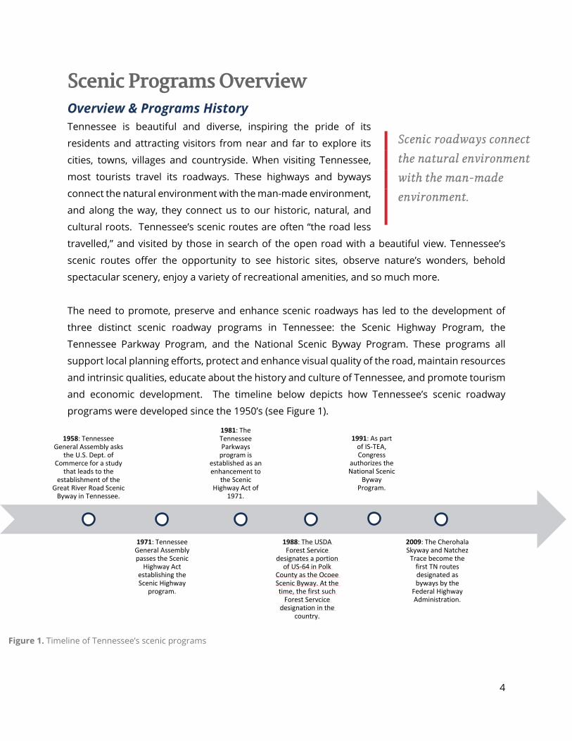
The need to promote, preserve and enhance scenic roadways has led to the development of
three distinct scenic roadway programs in Tennessee: the Scenic Highway Program, the
Tennessee Parkway Program, and the National Scenic Byway Program. These programs all
support local planning efforts, protect and enhance visual quality of the road, maintain resources
and intrinsic qualities, educate about the history and culture of Tennessee, and promote tourism
and economic development. The timeline below depicts how Tennessee’s scenic roadway
programs were developed since the 1950’s (see Figure 1).
Scenic roadways connect the natural environment with the man-made environment.
1958: Tennessee General Assembly asks
the U.S. Dept. of Commerce for a study
that leads to the establishment of the
Great River Road Scenic Byway in Tennessee.
1971: Tennessee General Assembly passes the Scenic
Highway Act establishing the Scenic Highway
program.
1981: The Tennessee Parkways
program is established as an enhancement to
the Scenic Highway Act of
1971.
1988: The USDA Forest Service
designates a portion of US-64 in Polk
County as the Ocoee Scenic Byway. At the time, the first such
Forest Servcice designation in the
country.
1991: As part of IS-TEA, Congress
authorizes the National Scenic
Byway Program.
2009: The Cherohala Skyway and Natchez
Trace become the first TN routes designated as byways by the
Federal Highway Administration.
Figure 1. Timeline of Tennessee’s scenic programs
5
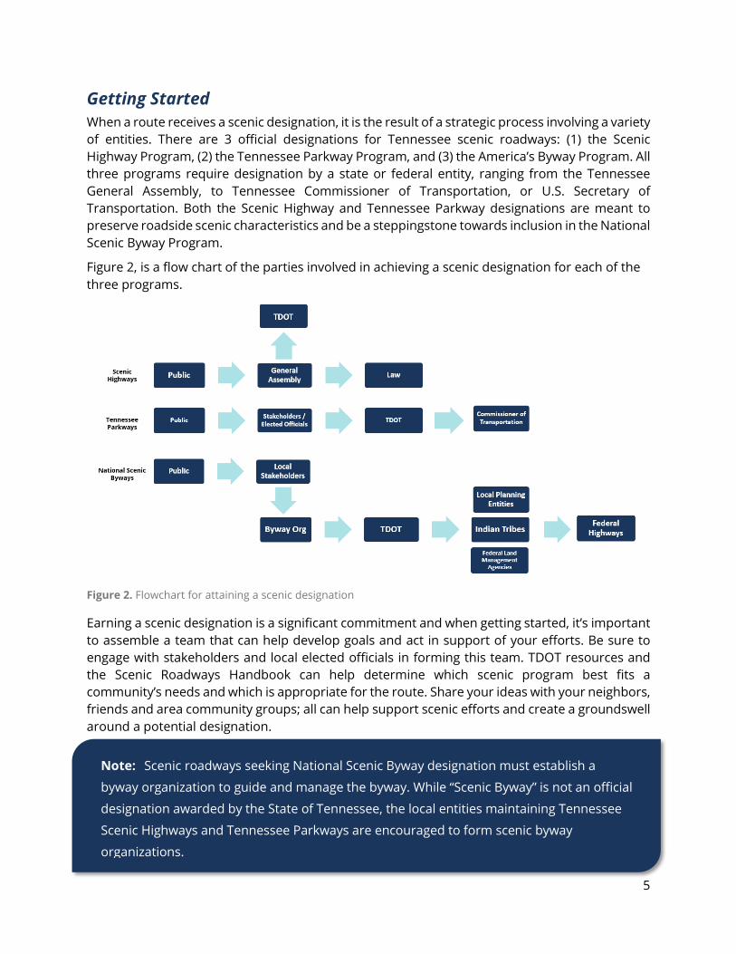
Getting Started When a route receives a scenic designation, it is the result of a strategic process involving a variety of entities. There are 3 official designations for Tennessee scenic roadways: (1) the Scenic Highway Program, (2) the Tennessee Parkway Program, and (3) the America’s Byway Program. All three programs require designation by a state or federal entity, ranging from the Tennessee General Assembly, to Tennessee Commissioner of Transportation, or U.S. Secretary of Transportation. Both the Scenic Highway and Tennessee Parkway designations are meant to preserve roadside scenic characteristics and be a steppingstone towards inclusion in the National Scenic Byway Program.
Figure 2, is a flow chart of the parties involved in achieving a scenic designation for each of the three programs.
Figure 2. Flowchart for attaining a scenic designation
Earning a scenic designation is a significant commitment and when getting started, it’s important to assemble a team that can help develop goals and act in support of your efforts. Be sure to engage with stakeholders and local elected officials in forming this team. TDOT resources and the Scenic Roadways Handbook can help determine which scenic program best fits a community’s needs and which is appropriate for the route. Share your ideas with your neighbors, friends and area community groups; all can help support scenic efforts and create a groundswell around a potential designation.
Note: Scenic roadways seeking National Scenic Byway designation must establish a
byway organization to guide and manage the byway. While “Scenic Byway” is not an official
designation awarded by the State of Tennessee, the local entities maintaining Tennessee
Scenic Highways and Tennessee Parkways are encouraged to form scenic byway
organizations.
6
Scenic Highways are scenic routes in Tennessee, as designated through legislation enacted by the Tennessee General Assembly. Eligible routes for Scenic Highway designation can be either local roads or Tennessee State Routes. Interested individuals or entities should contact their appropriate state legislators for guidance on how to get started. TDOT’s Highway Beautification Office can also provide support and advice navigating the designation process.
Tennessee Parkways are routes designated at the discretion of the Commissioner of
Transportation. Eligibility for Tennessee Parkways is limited to State Routes that intersect with
existing designated scenic routes. Interested communities may submit a competed application
to TDOT. Be sure to engage with all appropriate city and county elected officials, so they can act
in support of the nomination. TDOT staff will review application materials and provide a
recommendation to the Commissioner, who ultimately decides if a designation is warranted.
America’s Byways are a select collection of roughly 150 routes across America, including
National Scenic Byways and All-American Roads, which are designated by the U.S. Secretary of
Transportation and have the support of TDOT. These special routes tell unique stories about the
country and exhibit at least one of the six core byway intrinsic qualities. These intrinsic qualities
are scenic, natural, historic, recreational, archaeological, or cultural and contribute a unique
experience for the travelling public. Eligibility is limited to state designated scenic routes with an
established byway organization and a Corridor Management Plan. Tennessee currently has six
nationally designated routes: The Great River Road, Woodlands Trace, Natchez Trace, East
Tennessee Crossing, Cherohala Skyway and the Ocoee Scenic Byway.
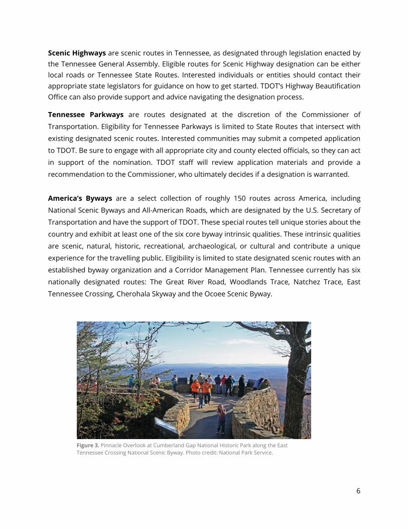
Figure 3. Pinnacle Overlook at Cumberland Gap National Historic Park along the East Tennessee Crossing National Scenic Byway. Photo credit: National Park Service.
7
Tennessee’s Scenic Programs Scenic Highway Program Tennessee’s Scenic Highway program was established by
the Scenic Highway Act of 1971. The Act provided for a
network of routes that have logical termini and are
alternative routes to highly traveled roads; preserve and
protect historic, scenic, and natural qualities, furnish
motorists with safe and attractive routes to experience the beauty of Tennessee.
Program Eligibility
The Scenic Highways Program offers the most flexibility for route eligibility. Scenic Highway
routes can be either local/county roads or Tennessee State Routes. Unlike the Tennessee
Parkways Program, Scenic Highway routes are not required to intersect with or have termini
adjacent to other routes designated as scenic. To apply for a Scenic Highway designation, begin
by providing your State Representative or State Senator with a written request that conveys how
a designation will be used to preserve the special character of a route and outline any organized,
local support for designation.
The Tennessee General Assembly codified regulations for the program within the law, TCA § 54-
27-114, which are detailed in the graphic on the next page. Preservation of historic, scenic, and
natural qualities along a Scenic Highway is accomplished with regulations that address building
heights, junkyards, outdoor advertising, and illegal dumping.
Scenic Highways preserve and protect historical, scenic and natural qualities.
Figure 4. Map of Tennessee Scenic Highway routes
8
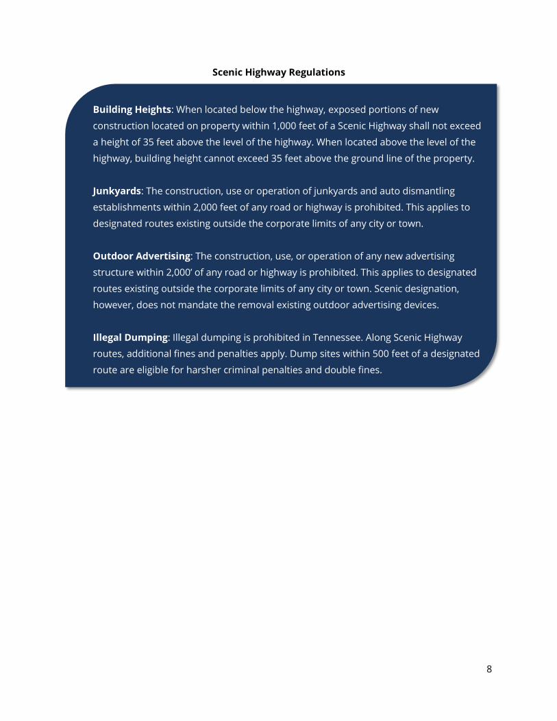
Scenic Highway Regulations
Building Heights: When located below the highway, exposed portions of new
construction located on property within 1,000 feet of a Scenic Highway shall not exceed
a height of 35 feet above the level of the highway. When located above the level of the
highway, building height cannot exceed 35 feet above the ground line of the property.
Junkyards: The construction, use or operation of junkyards and auto dismantling
establishments within 2,000 feet of any road or highway is prohibited. This applies to
designated routes existing outside the corporate limits of any city or town.
Outdoor Advertising: The construction, use, or operation of any new advertising
structure within 2,000’ of any road or highway is prohibited. This applies to designated
routes existing outside the corporate limits of any city or town. Scenic designation,
however, does not mandate the removal existing outdoor advertising devices.
Illegal Dumping: Illegal dumping is prohibited in Tennessee. Along Scenic Highway
routes, additional fines and penalties apply. Dump sites within 500 feet of a designated
route are eligible for harsher criminal penalties and double fines.
9
Tennessee Parkways Program The Tennessee Parkways program was established as
part of Governor Lamar Alexander’s Safe Growth Plan in
1981, to be an enhancement to the Scenic Highway
Program. The program has different eligibility
requirements than the Scenic Highways Program, and
slightly reduced restrictions on encroaching outdoor
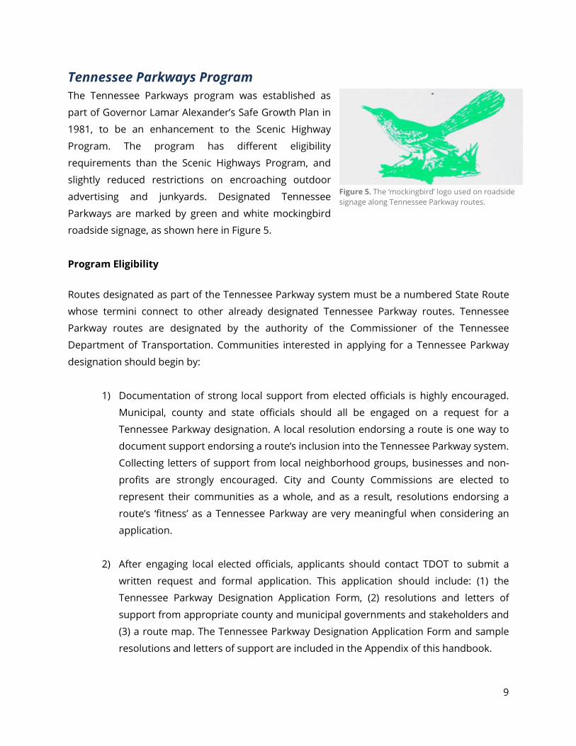
advertising and junkyards. Designated Tennessee
Parkways are marked by green and white mockingbird
roadside signage, as shown here in Figure 5.
Program Eligibility
Routes designated as part of the Tennessee Parkway system must be a numbered State Route
whose termini connect to other already designated Tennessee Parkway routes. Tennessee
Parkway routes are designated by the authority of the Commissioner of the Tennessee
Department of Transportation. Communities interested in applying for a Tennessee Parkway
designation should begin by:
1) Documentation of strong local support from elected officials is highly encouraged.
Municipal, county and state officials should all be engaged on a request for a
Tennessee Parkway designation. A local resolution endorsing a route is one way to
document support endorsing a route’s inclusion into the Tennessee Parkway system.
Collecting letters of support from local neighborhood groups, businesses and non-
profits are strongly encouraged. City and County Commissions are elected to
represent their communities as a whole, and as a result, resolutions endorsing a
route’s ‘fitness’ as a Tennessee Parkway are very meaningful when considering an
application.
2) After engaging local elected officials, applicants should contact TDOT to submit a
written request and formal application. This application should include: (1) the
Tennessee Parkway Designation Application Form, (2) resolutions and letters of
support from appropriate county and municipal governments and stakeholders and
(3) a route map. The Tennessee Parkway Designation Application Form and sample
resolutions and letters of support are included in the Appendix of this handbook.
Figure 5. The ‘mockingbird’ logo used on roadside signage along Tennessee Parkway routes.
10
3) Once a completed application is received, TDOT’s Highway Beautification Office,
conducts a field visit of the route to analyze the special qualities and features of the
routes. They then make a recommendation to the Commissioner of Transportation
concerning inclusion in the system.
4) The Commissioner of Transportation considers the recommendation of the Highway
Beautification Office, along with the application and local support, and planning
considerations, to make the final determination for designation.
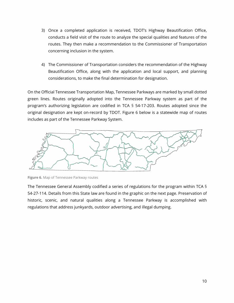
On the Official Tennessee Transportation Map, Tennessee Parkways are marked by small dotted
green lines. Routes originally adopted into the Tennessee Parkway system as part of the
program’s authorizing legislation are codified in TCA § 54-17-203. Routes adopted since the
original designation are kept on-record by TDOT. Figure 6 below is a statewide map of routes
includes as part of the Tennessee Parkway System.
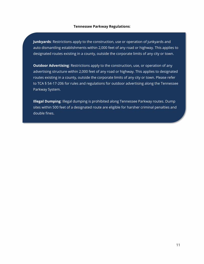
The Tennessee General Assembly codified a series of regulations for the program within TCA §
54-27-114. Details from this State law are found in the graphic on the next page. Preservation of
historic, scenic, and natural qualities along a Tennessee Parkway is accomplished with
regulations that address junkyards, outdoor advertising, and illegal dumping.
Figure 6. Map of Tennessee Parkway routes
11
Tennessee Parkway Regulations:
Junkyards: Restrictions apply to the construction, use or operation of junkyards and
auto dismantling establishments within 2,000 feet of any road or highway. This applies to
designated routes existing in a county, outside the corporate limits of any city or town.
Outdoor Advertising: Restrictions apply to the construction, use, or operation of any
advertising structure within 2,000 feet of any road or highway. This applies to designated
routes existing in a county, outside the corporate limits of any city or town. Please refer
to TCA § 54-17-206 for rules and regulations for outdoor advertising along the Tennessee
Parkway System.
Illegal Dumping: Illegal dumping is prohibited along Tennessee Parkway routes. Dump
sites within 500 feet of a designated route are eligible for harsher criminal penalties and
double fines.
12
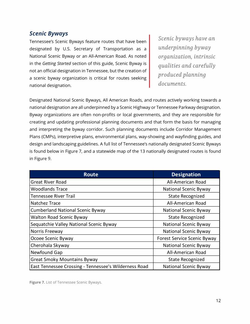
Scenic Byways Tennessee’s Scenic Byways feature routes that have been
designated by U.S. Secretary of Transportation as a
National Scenic Byway or an All-American Road. As noted
in the Getting Started section of this guide, Scenic Byway is
not an official designation in Tennessee, but the creation of
a scenic byway organization is critical for routes seeking
national designation.
Designated National Scenic Byways, All American Roads, and routes actively working towards a
national designation are all underpinned by a Scenic Highway or Tennessee Parkway designation.
Byway organizations are often non-profits or local governments, and they are responsible for
creating and updating professional planning documents and that form the basis for managing
and interpreting the byway corridor. Such planning documents include Corridor Management
Plans (CMPs), interpretive plans, environmental plans, way-showing and wayfinding guides, and
design and landscaping guidelines. A full list of Tennessee’s nationally designated Scenic Byways
is found below in Figure 7, and a statewide map of the 13 nationally designated routes is found
in Figure 9.
Route Designation Great River Road All-American RoadWoodlands Trace National Scenic BywayTennessee River Trail State RecognizedNatchez Trace All-American RoadCumberland National Scenic Byway National Scenic BywayWalton Road Scenic Byway State RecognizedSequatchie Valley National Scenic Byway National Scenic BywayNorris Freeway National Scenic BywayOcoee Scenic Byway Forest Service Scenic BywayCherohala Skyway National Scenic BywayNewfound Gap All-American RoadGreat Smoky Mountains Byway State RecognizedEast Tennessee Crossing - Tennessee's Wilderness Road National Scenic Byway
Scenic byways have an underpinning byway organization, intrinsic qualities and carefully produced planning documents.
Figure 7. List of Tennessee Scenic Byways.
13
The formation of a scenic byway organization is a planning-focused process that can have
significant benefits for a community. When considering becoming a byway, it’s important to
pursue the designation for reasons that support community goals, needs, and the desire for
economic development. Often, a community will choose to pursue byway status because they
intend to preserve their rural character or historic features. A community could also leverage
byway designation for economic development, increasing revenues from tourism and
maintaining lower property taxes. A summary of the byway organization process is outlined
below:
1) Receive either a Scenic Highway or Tennessee Parkway designation from the State of
Tennessee. This designation is the first step in preserving intrinsic qualities of a byway
and is a requirement of all routes admitted into the America’s Byways Program.
2) Local stakeholders should assemble a scenic committee or a non-profit to serve as a
Byway Organization. This organization can be affiliated with a local government or
regional planning entity and should be capable of meeting regularly and acting on
behalf of the byway. This Byway Organization should also be representative of the
various interests along a byway route and able to raise funds in support of byway
projects because most byway grants require a local match.
3) The Byway Organization will need to establish an initial list of byway priorities,
maintenance activities and potential projects. The organization should work towards
completing a Corridor Management Plan that both engages the public and
encompasses formatting required by the America’s Byways Program. TDOT should be
a contributing resource in the development of a byway’s Corridor Management Plan.
4) As the route’s Corridor Management Plan is being developed, the Byway Organization
should engage any local planning entities, Indian tribes, and Federal land
management agencies for input on the intrinsic qualities and potential projects. These
entities will need to support local byway efforts and endorse future Federal
designations.
5) Once a scenic byway organization is formed and a CMP has local entity support, the
organization is eligible to apply for a national designation from the U.S. Secretary of
Transportation. Federal designations come as either a National Scenic Byway or an
All-American Road, and more information about both designations are found in the
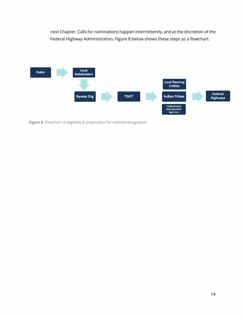
14
next Chapter. Calls for nominations happen intermittently, and at the discretion of the
Federal Highway Administration. Figure 8 below shows these steps as a flowchart.
Figure 8. Flowchart of eligibility & preparation for national designation
15
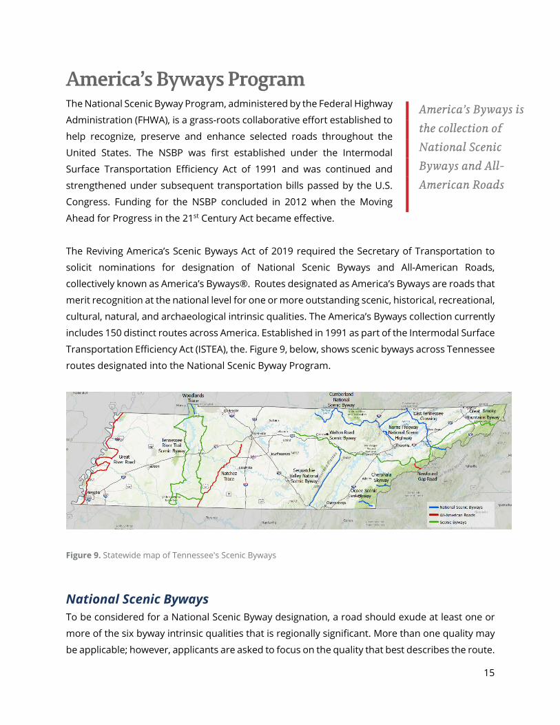
America’s Byways Program The National Scenic Byway Program, administered by the Federal Highway
Administration (FHWA), is a grass-roots collaborative effort established to
help recognize, preserve and enhance selected roads throughout the
United States. The NSBP was first established under the Intermodal
Surface Transportation Efficiency Act of 1991 and was continued and
strengthened under subsequent transportation bills passed by the U.S.
Congress. Funding for the NSBP concluded in 2012 when the Moving
Ahead for Progress in the 21st Century Act became effective.
The Reviving America’s Scenic Byways Act of 2019 required the Secretary of Transportation to
solicit nominations for designation of National Scenic Byways and All-American Roads,
collectively known as America’s Byways®. Routes designated as America’s Byways are roads that
merit recognition at the national level for one or more outstanding scenic, historical, recreational,
cultural, natural, and archaeological intrinsic qualities. The America’s Byways collection currently
includes 150 distinct routes across America. Established in 1991 as part of the Intermodal Surface
Transportation Efficiency Act (ISTEA), the. Figure 9, below, shows scenic byways across Tennessee
routes designated into the National Scenic Byway Program.
Figure 9. Statewide map of Tennessee's Scenic Byways
National Scenic Byways To be considered for a National Scenic Byway designation, a road should exude at least one or
more of the six byway intrinsic qualities that is regionally significant. More than one quality may
be applicable; however, applicants are asked to focus on the quality that best describes the route.
America’s Byways is the collection of National Scenic Byways and All-American Roads
16
The six intrinsic qualities are scenic natural, historic, cultural, archeological and recreational, and
a full description of each is found in Appendix E.
All-American Roads An All-American Road designation requires at least two of the six different types of intrinsic
qualities that are nationally significant. These qualities should provide a ‘one-of-a-kind’
experience for the visitor and the route, itself, is meant to be a primary destination for those
travelling.
America’s Byways Program Nomination Process There is no set cycle for applying to the America’s Byways Program.
Prior to the Fiscal Year (FY) 2020 one-time solicitation for
nominations, the last round of designations occurred in 2009.
Should the FHWA solicit a future call for nominations, TDOT’s
Highway Beautification Office will notify local partners of the
designation opportunity.
Practically anyone can nominate a road for national designation, but
those applicants who are seeking designation as a National Scenic
Byway or All-American Road must process their application through
TDOT. Community and elected official support of a national designation application is essential.
Additionally, in order to qualify for national designation, a byway must first be designated either
a Scenic Highway or Tennessee Parkway.
When considering nomination of a route, keep in mind the four core elements of a byway: (1) the
significance either regionally or nationally of the Intrinsic Quality(s) along your byway that merit
national designation; (2) the importance of a strong Corridor Management Plan (CMP) that
supports preservation, enhancement and promotion of the route’s Intrinsic Quality(s); (3)
providing a superior visitor experience; and (4) sustainability in the form of community and
organizational support.
Potential applicants should become familiar with nominating instructions for the national
program, found at https://www.fhwa.dot.gov/hep/scenic_byways/nominations/. These
instructions clarify the requirements and terminology used at the national level.
Figure 10. Logo of the National Scenic Byway Program
17
The nomination process is as follows:
1) TDOT notifies state byway leaders via email when FHWA solicits nominations.
2) Applicant completes the appropriate areas of the nomination form and forwards to TDOT,
along with their CMP for review.
3) TDOT evaluates the nomination application and the CMP, and sends comments back to
the applicant to make necessary revisions.
4) Applicant revises, if necessary, and forwards one final application package and two copies
(including attachments) to TDOT.
5) TDOT submits the application to the Commissioner of Transportation for approval.
6) TDOT submits the application to FHWA electronically.
Removal of National Designation The U.S. Secretary of Transportation may rescind the designation of any National Scenic Byway
or All-American Road if it no longer possesses the intrinsic qualities or meets the criteria which
supported designation. This determination is made if the local and/or state commitments
described in a CMP have not been sufficiently met to retain an adequate level of intrinsic quality
to merit designation. In addition, if a byway has been designated for more than one intrinsic
quality, the diminishing of one of those qualities could result in de-designation of the byway.
It is the State’s responsibility to assure that the intrinsic qualities of the byway are being properly
maintained, in accordance with the National Scenic Byway CMP. If the byway has not been
maintained sufficiently to retain its designation, the state and/or federal agency will be notified
of such finding and allowed 90 days for corrective actions before the U.S. Secretary of
Transportation may begin formal designation removal.
Tennessee’s Byway Collection As of July 2021, Tennessee has the most nationally designated byway routes of any state east of
the Mississippi River. It’s ten Forest Service Scenic Byways, National Scenic Byways, and All-
American Roads give it the fourth most in the country. Legendary routes such as the Great River
Road, Natchez Trace and Newfound Gap give Tennessee a coveted All-American Road in each
Grand Division of the State. Rounds of designations for these byways occurred in 1988, 1996,
2009 and 2021. Figure 11, below, shows the date of designation and intrinsic quality(s) associated
with each byway’s designation.
18
Tennessee’s collection of 10 nationally-designated byway routes includes:
Great River Road (Memphis Area; 240 miles; Starts: Memphis) - Tennessee’s Great River Road is the state’s westernmost scenic route and 1 of its 3 All-American Roads. Nationally, the route runs along both sides of the Mississippi River across 10 states, from the headwaters in Minnesota to the lower delta in Louisiana. The Tennessee portion of the Great River Road is teeming with culture and history. Visitors can discover 25,000 pristine acres of flooded forest at Reelfoot Lake State Park, experience the home of “Roots” author Alex Haley, feel the spirit of blues legends like B.B. King on Beale Street in Memphis, and take a stroll through Elvis Presley’s Graceland®. Travel Tennessee’s Great River Road for unmatched scenery and experiences in the Lower Mississippi Valley. Woodlands Trace (Nashville Area; 13.5 miles; Starts: Dover) - Spanning forested ridgetops between the Tennessee and Cumberland Rivers, the Woodlands Trace National Scenic Byway travels the length of Land Between the Lakes National Recreation Area in Kentucky and Tennessee. The route offers visitors many chances to hike, camp, and learn about the area’s rich culture and history. While travelling the Woodlands Trace, get up close and personal with majestic wildlife at the South Bison Range, experience the Homeplace 1850’s Working Farm, and see the ruins of an original nineteenth century iron furnace. Natchez Trace (Nashville Area; 102 miles; Start Pasquo) - The Natchez Trace, one Tennessee’s 3 All-American Roads, stretches 444 miles from Nashville to Natchez, Mississippi. The route follows the original travel corridor used by Native Americans, boatmen dubbed the “Kaintucks”,
Route Name & Date Designated Intrinsic Quality(s)Great River Road (NSB-2009; AAR-2021) Cultural, HistoricWoodlands Trace (NSB-2009) RecreationalNatchez Trace (AAR-1996) Recreational, HistoricCumberland National Scenic Byway (NSB-2021) HistoricSequatchie Valley National Scenic Byway (NSB-2021) Scenic Norris Freeway (NSB-2021) Recreational Ocoee Scenic Byway (NSB-1988) Forest Service DesignationCherohala Skyway (NSB-1996) Scenic Newfound Gap (AAR-2021) Historic, Scenic East Tennessee Crossing - Tennessee's Wilderness Road (NSB-2009) Historic
Figure 11. List of Tennessee national designation & intrinsic qualities.
19
European settlers, merchants, soldiers, and future presidents. Now maintained by the National Park Service, the Natchez Trace draws bicyclists, motorcyclists, horseback riders, campers, hikers, and Sunday drivers of all ages, eager to drive through the 10,000 years of history interpreted along the route. Sequatchie Valley Scenic Byway (Chattanooga Area; 65 miles: Starts: Jasper) - The Sequatchie Valley National Scenic Byway is the perfect playground for outdoor recreation enthusiasts. Rock climbing, bicycling, kayaking, and fishing are just some of the activities common to the Sequatchie Valley. The byway route follows the heart of the Sequatchie Valley, and connects several communities in Tennessee’s smallest and most distinctive physiographic region. Formed over millions of years, the Sequatchie Valley is bordered to the west by Walden’s Ridge and to the east by the escarpment of the Cumberland Plateau. Panoramic views are found throughout this unique part of Tennessee.
Norris Freeway (Knoxville Area; 21 miles; Starts: Rocky Top) - The Norris Freeway National Scenic Byway was originally built in 1934 as a supply route for the Norris Dam, Tennessee Valley Authority’s first hydroelectric project. The route was Tennessee’s first limited access freeway and structures along the route were built using a cohesive Art Moderne design. The route itself is a winding, wooded road through lush countryside and waterways, which boast some of the best trout fishing in the state. Today, the area is home to the Town of Norris and Norris Dam State Park, as well as prominent hiking and horseback riding trails. Cumberland National Scenic Byway (Knoxville Area; 156 miles; Starts: Cumberland Gap) - The Cumberland National Scenic Byway crosses 8 counties in Tennessee’s Upper Cumberland and echoes with the footsteps of such Tennessee luminaries as Sgt. Alvin C. York and Cordell Hull. The byway
connects the Cumberland Gap in the east to the Cumberland River in the west. Through several sites, such as the Rugby Victorian village and Obey-Cumberland River convergence, it also tells the story of the region’s historical significance. Dale Hollow Lake and the Big South Fork National River and Recreation Area also provide visitors with premier opportunities for outdoor recreation. East Tennessee Crossing – Tennessee’s Wilderness Road (Knoxville Area; 83 miles; Starts: Cumberland Gap) - The East Tennessee Crossing National Scenic Byway connects the travelling public to Appalachian history and culture. The byway is part of the Wilderness Road Heritage Highway, the route Cherokee Warriors originally used to cross the mountains and which pioneers used to move west. Quaint mountain communities and scenic mountain views are found throughout the route, which connects the Cumberland Gap National Historic Park, Great Smoky Mountains National Park and the Cherokee National Forest.
20
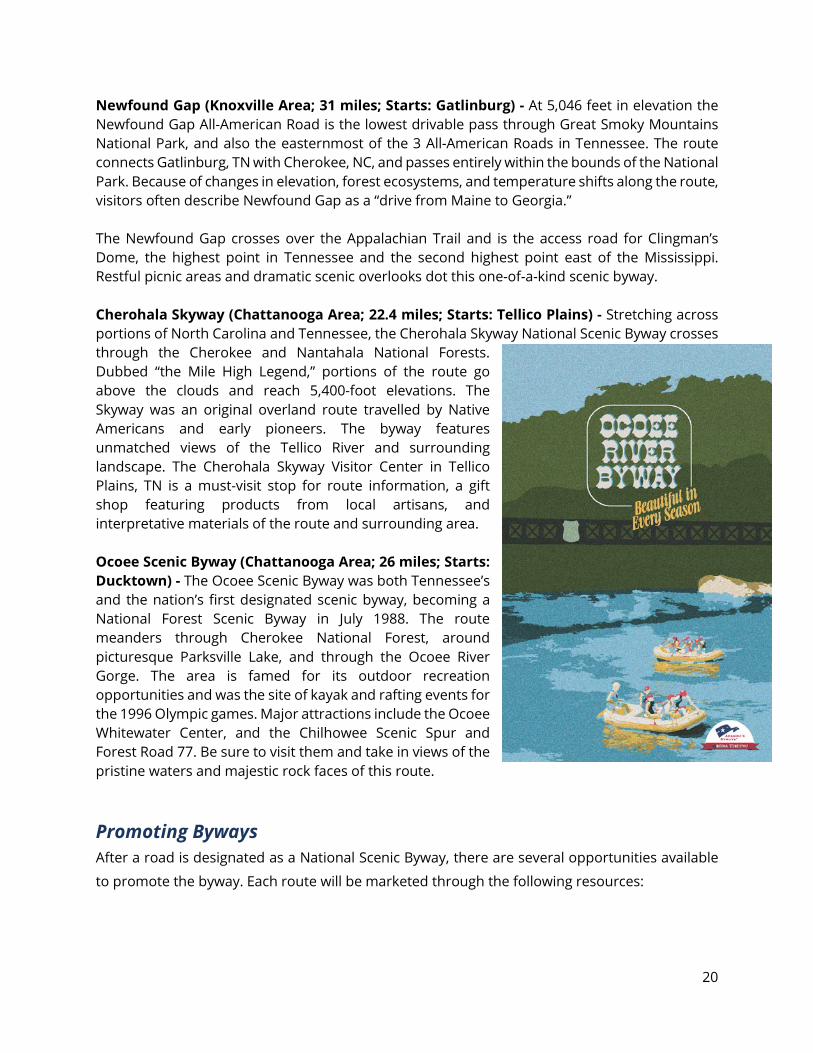
Newfound Gap (Knoxville Area; 31 miles; Starts: Gatlinburg) - At 5,046 feet in elevation the Newfound Gap All-American Road is the lowest drivable pass through Great Smoky Mountains National Park, and also the easternmost of the 3 All-American Roads in Tennessee. The route connects Gatlinburg, TN with Cherokee, NC, and passes entirely within the bounds of the National Park. Because of changes in elevation, forest ecosystems, and temperature shifts along the route, visitors often describe Newfound Gap as a “drive from Maine to Georgia.” The Newfound Gap crosses over the Appalachian Trail and is the access road for Clingman’s Dome, the highest point in Tennessee and the second highest point east of the Mississippi. Restful picnic areas and dramatic scenic overlooks dot this one-of-a-kind scenic byway. Cherohala Skyway (Chattanooga Area; 22.4 miles; Starts: Tellico Plains) - Stretching across portions of North Carolina and Tennessee, the Cherohala Skyway National Scenic Byway crosses through the Cherokee and Nantahala National Forests. Dubbed “the Mile High Legend,” portions of the route go above the clouds and reach 5,400-foot elevations. The Skyway was an original overland route travelled by Native Americans and early pioneers. The byway features unmatched views of the Tellico River and surrounding landscape. The Cherohala Skyway Visitor Center in Tellico Plains, TN is a must-visit stop for route information, a gift shop featuring products from local artisans, and interpretative materials of the route and surrounding area. Ocoee Scenic Byway (Chattanooga Area; 26 miles; Starts: Ducktown) - The Ocoee Scenic Byway was both Tennessee’s and the nation’s first designated scenic byway, becoming a National Forest Scenic Byway in July 1988. The route meanders through Cherokee National Forest, around picturesque Parksville Lake, and through the Ocoee River Gorge. The area is famed for its outdoor recreation opportunities and was the site of kayak and rafting events for the 1996 Olympic games. Major attractions include the Ocoee Whitewater Center, and the Chilhowee Scenic Spur and Forest Road 77. Be sure to visit them and take in views of the pristine waters and majestic rock faces of this route.
Promoting Byways After a road is designated as a National Scenic Byway, there are several opportunities available
to promote the byway. Each route will be marketed through the following resources:
21
America’s Byways® - This is the umbrella term used for marketing and resources for the 150 distinct and diverse roads designated by the U.S. Secretary of Transportation. Each nationally designated byway is featured on FHWA’s America’s Byways website and may use the America’s Byways logo for other marking resources.
Websites – There are two State of Tennessee websites
that promote byways: the state’s travel and tourism
website, https://www.tnvacation.com/trails-and-byways,
and the TDOT scenic roadways website,
https://www.tn.gov/tdot/environmental-
home/environmental-highway-beautification-
office/beautification-national-scenic-byways.html\.
Roadside Signage – TDOT is responsible for the
installation and maintenance of roadside signage
for scenic routes. Appendix I of this handbook
shows examples of scenic roadside signage in
Tennessee.
Tennessee Byways Publications – TDOT
produces a high-quality flip book and other
publications of all Scenic Byways and their intrinsic
qualities. These publications are updated
regularly.
Figure 12. Logo of the America’s Byways program.
Figure 13. Example of Tennessee Parkway Roadside Signage along the Cumberland National Scenic Byway in Scott County.
22
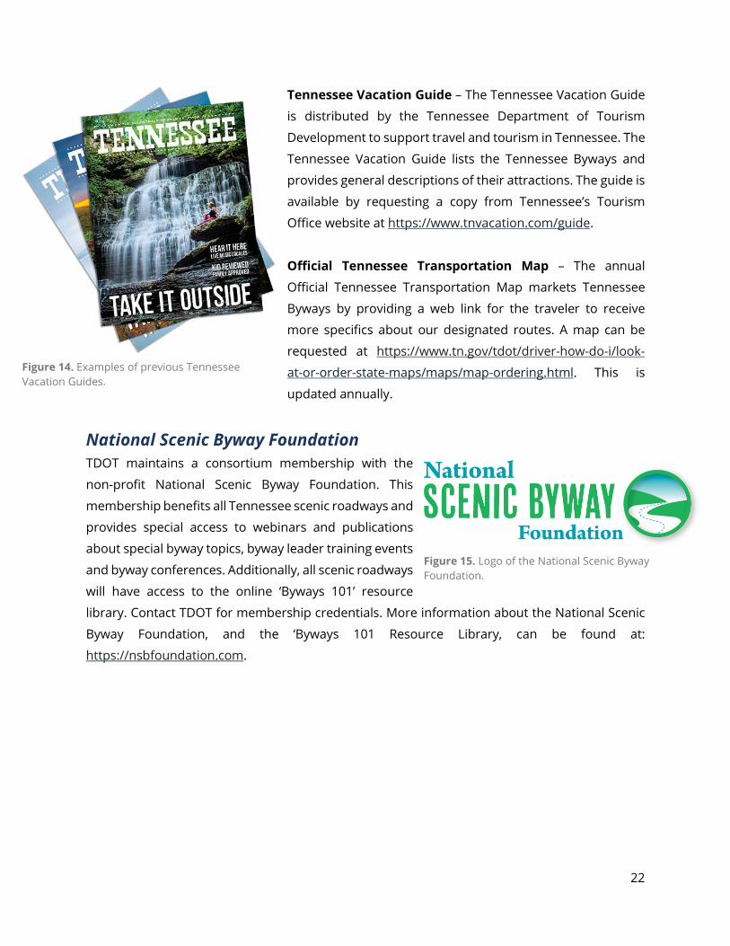
Tennessee Vacation Guide – The Tennessee Vacation Guide
is distributed by the Tennessee Department of Tourism
Development to support travel and tourism in Tennessee. The
Tennessee Vacation Guide lists the Tennessee Byways and
provides general descriptions of their attractions. The guide is
available by requesting a copy from Tennessee’s Tourism
Office website at https://www.tnvacation.com/guide.
Official Tennessee Transportation Map – The annual
Official Tennessee Transportation Map markets Tennessee
Byways by providing a web link for the traveler to receive
more specifics about our designated routes. A map can be
requested at https://www.tn.gov/tdot/driver-how-do-i/look-
at-or-order-state-maps/maps/map-ordering.html. This is
updated annually.
National Scenic Byway Foundation TDOT maintains a consortium membership with the
non-profit National Scenic Byway Foundation. This
membership benefits all Tennessee scenic roadways and
provides special access to webinars and publications
about special byway topics, byway leader training events
and byway conferences. Additionally, all scenic roadways
will have access to the online ‘Byways 101’ resource
library. Contact TDOT for membership credentials. More information about the National Scenic
Byway Foundation, and the ‘Byways 101 Resource Library, can be found at:
https://nsbfoundation.com.
Figure 14. Examples of previous Tennessee Vacation Guides.
Figure 15. Logo of the National Scenic Byway Foundation.
23
Sustaining a Byway National Scenic Byway Program Grants Federal support for nationally designated scenic byways does not stop with marketing and
promotion. The National Scenic Byway Program also offers the opportunity for program
participants to apply for project funding. Funding opportunities are announced through FHWA
and TDOT and interested byways must submit an electronic application. Application information
is found at https://www.fhwa.dot.gov/hep/scenic_byways/. Along with the online application, the
TDOT, as the state’s designated byway program agency, must submit a paper copy to the state’s
FHWA division.
A list of federal grants awarded to Tennessee Scenic Byways as part of the National Scenic Byway
Program grants is included as Appendix G of the Scenic Handbook.
National Scenic Byway Grant Categories
Corridor Management Planning – Activities related to safety improvements, access to
recreation, resource protection, interpretive projects or marketing program initiatives
could be considered in the implementation of the Corridor Management Plan. Travel and
per diem expenses for conferences, or training or technical assistance activities for
advancing a byway or the National Scenic Byway Program can also be considered.
Safety Improvements – Features necessary to reduce the likelihood of crashes and
vehicle/bicycle/pedestrian conflicts are just some of the roadside improvements eligible for
byway funds. The project must demonstrate that the improvements are necessary to
accommodate increased traffic and changes in the types of vehicles using the road. Only
when the project demonstrates these safety deficiencies can improvements such as
guardrails, shoulders, bridge rails and comparable road improvements be eligible for funds.
Byway Facilities – Construction of structures/facilities that include the development of
environmental documents, planning, design, engineering, purchase of right-of-way, land
or property, as well as supervising inspecting , actual building and all cost concerning the
construction of the project or facility are eligible for funds under this category.
24
National Scenic Byway Program grant funding is competitive and limited, but a byway can improve its application by providing as much detailed information as possible regarding each project element (i.e. supporting documents, maps, plans, photographs). This additional information will aide in the selection process and communicate the byway’s priorities. A clear and concise summary of the project, its enhancement of the byway’s intrinsic qualities, and how it benefits the byway’s traveler are critical to an application ‘s success. TDOT has identified the following key elements to help byways prioritize which ones could be selected:
Livability: TDOT has prioritized funding for projects along routes that promote livability through
integration of land use, transportation, housing and green space. Projects along nationally
designated routes which seek to improve quality of life will be given priority as long as they can
demonstrate added value, in addition to benefiting the byway traveler.
Access to Recreation – Roadway enhancement projects directly related to improving
access to recreational areas which have a clear demonstrated role in enhancing the
byway traveler experience will be considered in this category. Such modifications include
but are not limited to modifications to the roadway or parking facilities in order to
accommodate buses, recreation vehicles, or vehicles pulling trailers.
Interpretive Information – Tourist and interpretive information includes, but is not limited
to signs, brochures, pamphlets, maps, video tapes, audio tapes, CD’s, podcasts, a byway
website, interpretive exhibits and kiosks. It includes coordination of volunteers for living
history demonstrations, docents or step-on guide programs, and training for individuals to
inform byway travelers of the significance of the byway’s intrinsic qualities that form the
byway’s story. The information should reflect the entire byway and inform the traveler of
the significance of the intrinsic quality(s).
Marketing Program – A byway marketing plan is a detailed, written account and timetable
of the objectives and methods to be used to achieve marketing goals. A marketing program
could include research, branding a byway, and or marketing strategies (i.e. advertising,
trade shows, expos and conferences, public relations, media relations, promotions,
electronic marketing, hospitality training, and traveler’s tools). These programs should
include initiatives and activities that support the overall marketing strategy.
25
Greatest Strategic Benefits: Projects showcasing large-scale, high-cost planning, safety and
infrastructure improvements to roadway facilities while benefiting the byway traveler may be
given priority.
State, Indian Tribe and Byway Priority: Is the project highly ranked in planning documents
and/or by local planning authorities? Priority ranking of a project is a key factor in funding
selection.
Projects Meeting a Critical Need: A “critical need” can
be defined as activities used to build and strengthen a
sustainable organization, managing byway activities,
and implementing projects or other initiatives.
Funding Expenditures: Priority selection may be given
to states, Indian tribes, and byways that demonstrate a
high completion rate of previous projects and are
therefore considered better candidates for project
selection.
Ready to Implement: Shovel-ready projects prepared to begin construction upon selection will
be given preference. This prioritization ensures the timely use of funds and contributes to future
project prioritization under the Funding Expenditures criteria.
Leveraging of Private or Other Public Funding: Projects that use other funding sources to
complement requested byway funding will enable more projects to be funded overall.
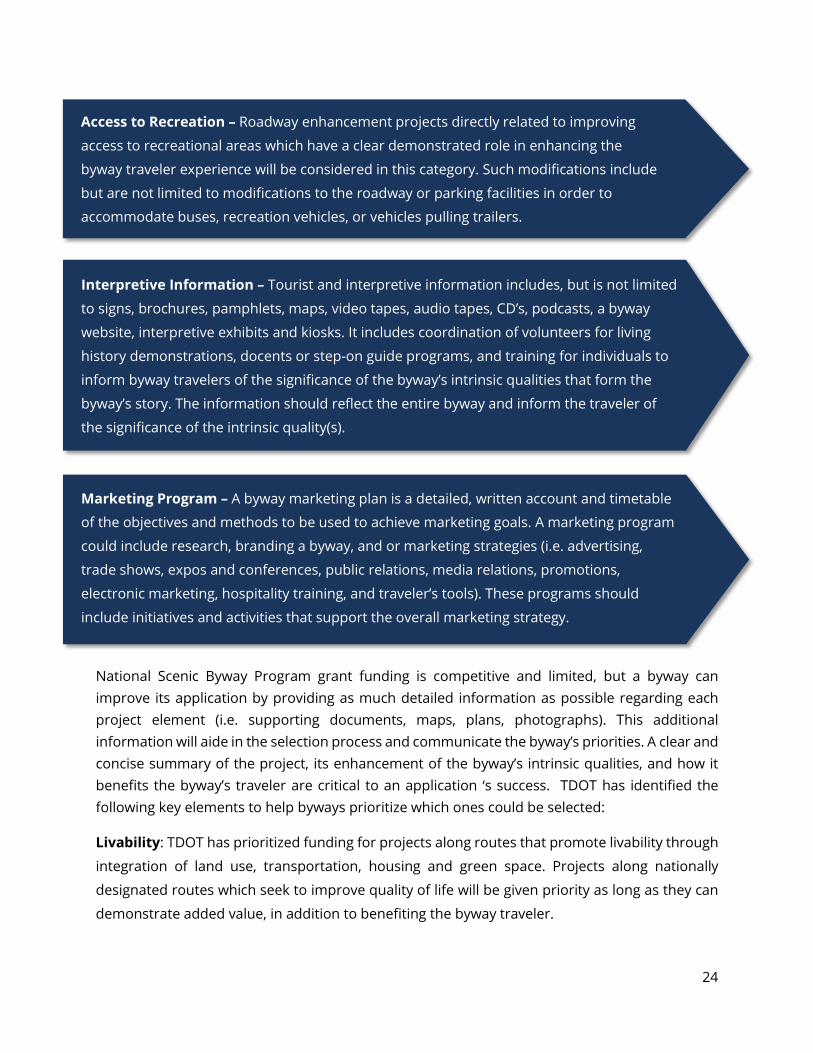
Tennessee Byway Projects Awarded a National Scenic Byway Grant: Appendix , below,
shows information regarding the 32 federal grants awarded to Tennessee byways as part of the
National Scenic Byway Program. These grants total $5,633,505 and have been awarded since
1999. An electronic version of this list can be accessed online, at
https://www.fhwa.dot.gov/hep/scenic_byways/grants/funded/advanced_search/index.cfm#resu
lts.
Figure 15. The Timberland Park in Williamson County (along the Natchez Trace) was partially funded using NSBP grants.
26
Additional Resources National Scenic Byway Program grants are not the only source of funding for sustaining byways.
Several programs, spanning from state funded TDOT opportunities to federally supported
environmental grants, offer byways access to resources for maintaining and improving their
unique intrinsic qualities. The remainder of this chapter will identify some alternate funding
sources for byway project funding, which could be used to meet the Leveraging of Private or
Other Public Funding criteria for prioritization under the National Scenic Byway Program.
Transportation Alternatives Program (TAP) – Federal Transportation Alternatives Program
funds have impacted a wide variety of communities and funded many different types of
transportation-related projects since its inception in 1991. This program is the largest source of
funding for trails and related facilities in Tennessee. Projects must relate to surface
transportation and applicants will compete among numerous projects. These grants are 80%
federal and 20% local funding, and applications must be submitted by a local government entity.
In Tennessee, the TDOT Local Programs Office is the agency responsible for administering these
funds. Grant applications and instructions can be found online at the TAP website at
https://www.tn.gov/tdot/program-development-and-
administration-home/local-programs/tap.html, or by calling (615)
741-9673.
North American Wetlands Conservation Act (NAWCA) – The
U.S. Fish and Wildlife Services Division of Bird Habitat
Conservation is responsible for facilitation of this grant program.
The NAWCA provides a matching program geared toward wetland
conservation for the benefit of migratory birds and other wildlife.
There are two grant programs available, the Standard Grant
Program and the Small Grant Program. Each requires matching
contributions by alternate sources of no less than a 1-to-1 ratio.
Funds from other Federal grant sources may contribute towards a
project but are not eligible as a match. More information can be
found at the U.S. Fish and Wildlife Service website at
https://www.fws.gov/birds/grants/north-american-wetland-conservation-act.php.
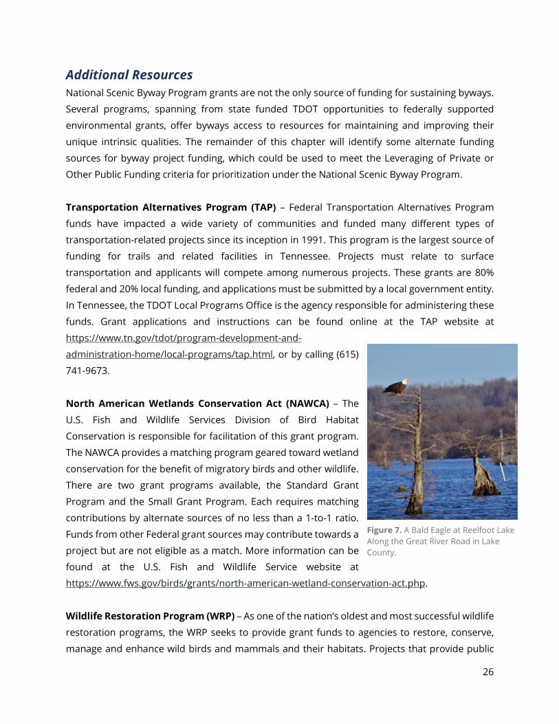
Wildlife Restoration Program (WRP) – As one of the nation’s oldest and most successful wildlife
restoration programs, the WRP seeks to provide grant funds to agencies to restore, conserve,
manage and enhance wild birds and mammals and their habitats. Projects that provide public
Figure 7. A Bald Eagle at Reelfoot Lake Along the Great River Road in Lake County.
27
use and access to wildlife resources will also be considered. These funds are disbursed to states
for approved grants on a reimbursement basis for up to 75% of the project costs and, in some
areas, up to 100% of the project costs. More information can be found on the U.S. Fish and
Wildlife Service at https://www.fws.gov/wsfrprograms/Subpages/GrantPrograms/WR/WR.htm.
Applications can be obtained by contacting the Wildlife and Sport Fish Restoration Office or by
applying online at www.grants.gov.
Boating Access Program (BAP) – As part of the Sports Fish Restoration Program, this program
seeks to provide grant funds to agencies for projects that provide access to America’s waterways
by developing new access facilities renovation, and/or improvement of existing facilities. Funds
are disbursed to states for approved grants on a reimbursement basis for up to 75% of the
project cost and, in some areas, up to 100% of the project cost. More information can be found
online, via the U.S. Fish and Wildlife Service’s website, at
https://www.fws.gov/wsfrprograms/subpages/grantprograms/boataccess/ba.htm.
National Forest Foundation (NFF) – As a non-profit organization, the
National Forest Foundation helps to fund projects that address invasive
species in, and adjacent to, National Forests and Grasslands. Funds are
disbursed by NFF match funds with local contributions. To apply for this
grant program, applicants can find more information online at
http://nationalforests.org/conserve/grantprograms.
National Park Foundation Active Trails Grant Program (ATGP) –
This program is designed to promote healthy lifestyles while
simultaneously protecting and enhancing national parks’ trail resources.
It encourages visitors to connect with their national parks through
recreation, hands-on trail work, and community engagement activities.
The grant application can be found online at
https://www.nationalparks.org/our-work/programs/active-trails.
Multimodal Access Grant (RTP) – TDOT’s Multimodal Access Grant is a state-funded program
created to support the transportation needs of pedestrians, bicyclists, and transit users through
infrastructure projects that address existing gaps along state routes. Multimodal facilities play an
important role in providing transportation choices for people across Tennessee. With half of all
trips in the United States being three miles or less, good walking, biking and transit facilities are
essential to the continued growth and success of our towns and cities. Multimodal Access Grant
Figure 8. Logo of the National Forest Scenic Byway Program. The Ocoee Scenic Byway in Polk County is Tennessee’s Lone National Forest Byway.
28
projects are state funded at 95 percent with a 5 percent local match. State match amount will not
exceed $950,000. Additional information about this grant opportunity can be found online at
https://www.tn.gov/tdot/multimodal-transportation-resources/multimodal-access-grant.html,
or by calling TDOT’s Multimodal Transportation Resources Division at (615) 253-1051.
Tennessee Agricultural Enhancement Program (TAEP) – This
Tennessee Department of Agriculture grant program was established in
2005 to provide cost sharing dollars to communities who invest by
planting large, canopy-style trees. Projects involving smaller, ornamental
trees do not qualify for this program. Traditionally, the annual
application period occurs in the fall of each year, usually between
September and October. Local governments and byway organizations
are eligible to make application for qualifying projects along a byway
route. For more information, please call (1-800) 342-8206, or visit
https://www.tn.gov/agriculture/farms/taep.html.
Recreational Trails Program (RTP) – This program is funded federally
but administered by the Tennessee Department of Environment and Conservation. RTP grant
funds help in the acquisition of land for trails, trails maintenance and restoration/rehabilitation,
trail construction, and trail head support facilities. Those eligible to apply for funding include
local, state and federal government agencies, as well as non-profits with a 501(c) (3) status that
have a written agreement in place with a government agency for trail management. Additional
information about RTP grant opportunities can be found online at
https://www.tn.gov/environment/about-tdec/grants/grants-recreation-grants/grants-recreation-
educational-trail-program.html.
Volkswagen Diesel Settlement – As a result of legal action against Volkswagen in 2015, the State
of Tennessee is a beneficiary of funding meant for projects to help reduce nitrogen oxide from
the atmosphere. Funding has been available since 2018 through an Environmental Mitigation
Trust, for eligible projects. These include the installation of charging infrastructure for alternate
and all-electric fueled vehicles. The Tennessee Department of Environment and Conservation is
a custodian of this funding and more information can be found either by calling (615) 613-1096
or online at https://www.tn.gov/environment/program-areas/energy/state-energy-office--seo-
/tennessee-and-the-volkswagen-diesel-settlement.html.
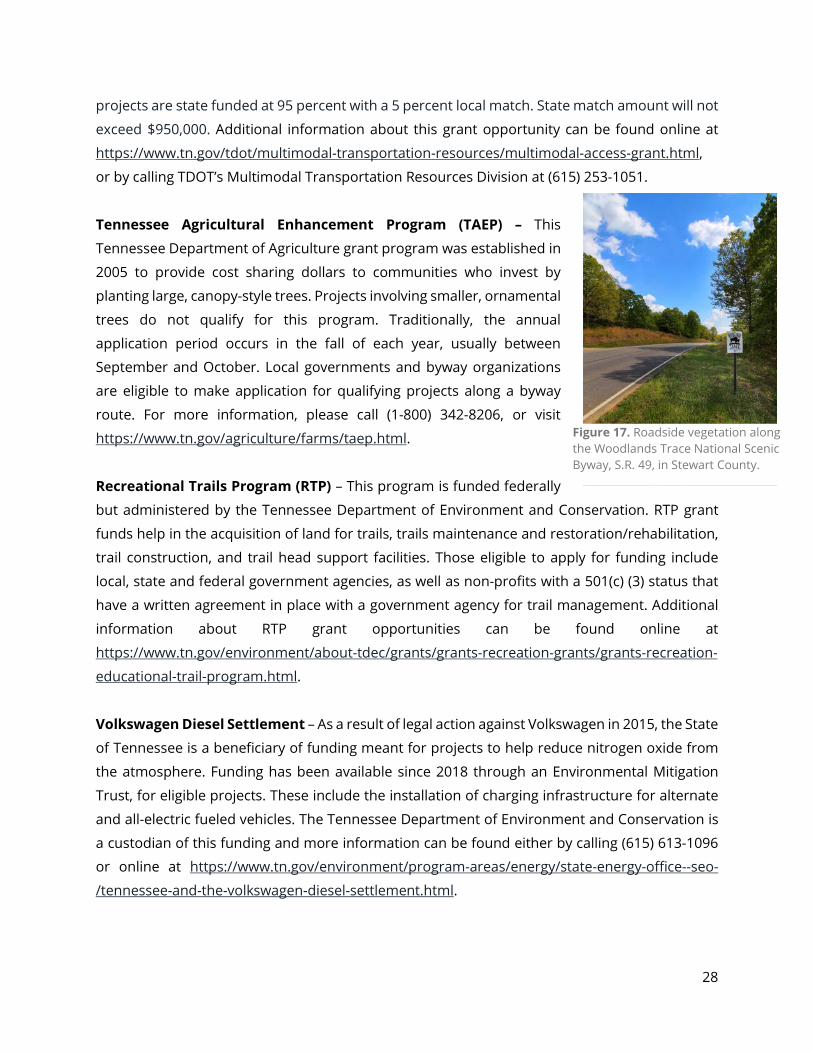
Figure 17. Roadside vegetation along the Woodlands Trace National Scenic Byway, S.R. 49, in Stewart County.
29
Bikes Belong Coalition (BBC) – As a program that strives to get more people bicycling, the Bikes
Belong Coalition supports projects that promote the momentum for bicycling in communities
across the country. Projects include bike trails, bike paths, BMX facilities, and large-scale bicycling
advocacy initiatives. Applicants have to meet specific requirements and there are geographic
restrictions. More information can be found online at http://www.bikesbelong.org/grants.
Community Transportation Planning Grant (CTPG) – This program assists rural communities
with planning efforts that connect transportation cohesiveness with statewide planning goals. It
funds the creation of planning documents that support improvements in traffic flow, safety and
overall efficiency of the transportation system. It also provides governments with planning
resources to achieve community visions as related to transportation and land use needs that
promote future economic growth.
County and municipal governments located outside an MPO planning boundary are eligible to
apply for funding. Additional grant information can be found at https://www.tn.gov/tdot/long-
range-planning-home/longrange-oct/longrange-planning-grant.html. For questions, contact
TDOT’s Office of Community Transportation at (615) 253-2428.
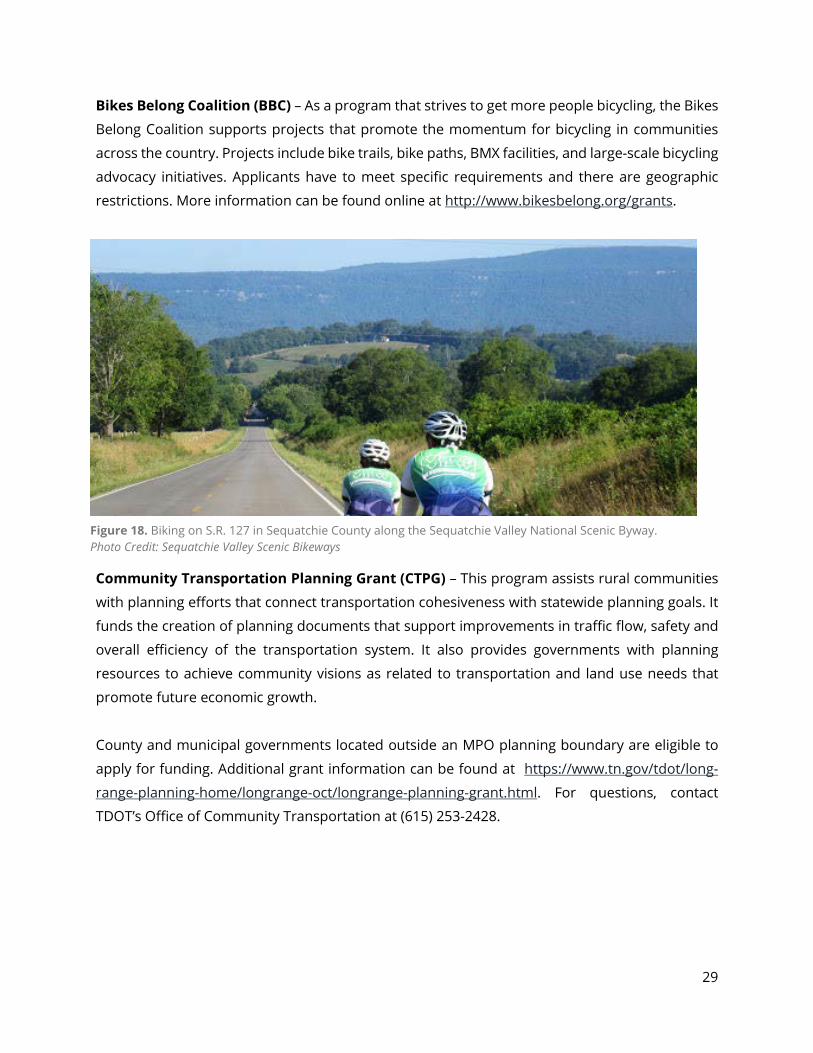
Figure 18. Biking on S.R. 127 in Sequatchie County along the Sequatchie Valley National Scenic Byway. Photo Credit: Sequatchie Valley Scenic Bikeways

30
Context Sensitive Solutions Feature Preservation, Maintenance & Enhancement As of December 31, 2018, there were 96,116 miles of public roads in Tennessee; 14,107 miles are
maintained by TDOT and 4,021 of these miles are designated as scenic. Applying solutions and
pursuing projects that are sensitive to a scenic route’s characteristics are important to
maintaining a route’s intrinsic qualities. A one-size-fits-all approach rarely works when dealing
with scenic routes. The purpose of this section is to provide a set of guidelines and resources for
byway organizations and the public for pursuing improvements, while still maintaining,
protecting and enhancing a roadway’s intrinsic qualities.
All individuals and organizations supporting a
route’s scenic designation should routinely seek out
best practices in how to preserve and enhance
these qualities. In addition to this text, three
publications can be a resource: the scenic byway’s
Corridor Management Plan, FHWA’s “Flexibility in
Highway Designs” publication, and “A Guide for
Applying AASHTO Policies to Achieve Flexibility in
Highway Design” from the American Association for
State Highway and Transportation Organization.
Route Safety When considering safety-related design changes to
a scenic or historic roadway, designers should strive
to retain, to the maximum extent possible, the
scenic and historic character of the roadway. Safety
improvements on scenic routes may require non-
traditional approaches in order to be appropriate
for scenic roads. These methods have concentrated
on physical modifications to the roadway and
roadside, such as widening lanes and shoulders,
adding guardrail, cutting trees, and changing the
vertical and horizontal geometry.
Elements Impacting a Scenic Route’s Character-Defining Features:
Safety Alignment & Geography Roadside Barriers Grading & Drainage
Traffic Control Devices Utilities Landscaping Bridges & Small Structures Signs Lighting Access
Roadside Enhancements Bicycles Maintenance Management of Publicly
Owned Land
31
Traditional roadway design techniques and methods will often degrade the visual quality that led
to a route’s scenic designation. For example, creating a wider road to reduce the apparent
dangers for a driver, usually results in higher vehicle speeds. This is especially problematic for
scenic roads, since a substantial proportion of the travelers are new to the road, wish to drive
slowly to enjoy the view, and often share the road with bicyclists. For byways, the application of
traditional safety strategies could result in an increase in accidents, due to the increased speed
differential between users.
All organizations and individuals involved in the design and engineering of route safety projects
on scenic routes should prioritize the following byway-specific strategies:
• Addressing Indentified Safety Concerns: Apply traffic calming measures; increase
visibility of a potential hazard, rather than removing it; increases in sight distance; traffic
control and regulation signage; lowering design speed; pavement striping and marking;
raised pavement markers; and street lighting.
• Compatibility of Safety Features: Safety related design changes to a scenic route
should be compatible with the byway’s character-defining features by minimizing the
visual contrast between the safety feature and its setting. Examples of this include using
steel-backed wood guardrails in a rustic or natural setting, or by using weathering steel
guardrails.
• Reinforce Desired Drivers Behavior: When confronting problems associated with travel
speeds well in-excess of posted limits, consideration should be given to improving the
driver’s behavior through appropriately concealed traffic calming techniques.
• The Value of Direct Observation: Direct observation in the field to understand the
causes of a safety problem may assist in identifying means to address the problem that
will not alter the scenic and historic character of the roadway.
Alignment & Geometry A roadway’s natural topography should be preserved to the maximum extent practical by
ensuring the roadway’s alignment and geometry fit in with the existing landscape. Best practices
for byway alignment and geometry include:
32
• Future Increased Capacity Needs: When addressing increased capacity needs, consider
whether an existing alternate or parallel route can carry increased capacity to allow the
byway to continue to serve its current function without need for redesign to carry
anticipated higher traffic volumes in the future.
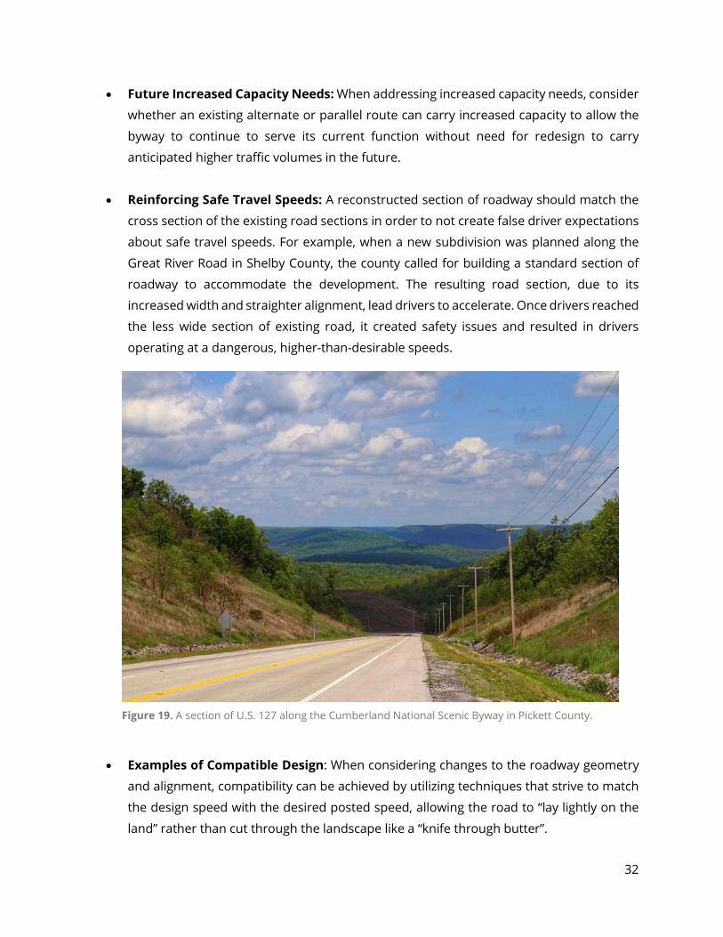
• Reinforcing Safe Travel Speeds: A reconstructed section of roadway should match the
cross section of the existing road sections in order to not create false driver expectations
about safe travel speeds. For example, when a new subdivision was planned along the
Great River Road in Shelby County, the county called for building a standard section of
roadway to accommodate the development. The resulting road section, due to its
increased width and straighter alignment, lead drivers to accelerate. Once drivers reached
the less wide section of existing road, it created safety issues and resulted in drivers
operating at a dangerous, higher-than-desirable speeds.
• Examples of Compatible Design: When considering changes to the roadway geometry
and alignment, compatibility can be achieved by utilizing techniques that strive to match
the design speed with the desired posted speed, allowing the road to “lay lightly on the
land” rather than cut through the landscape like a “knife through butter”.
Figure 19. A section of U.S. 127 along the Cumberland National Scenic Byway in Pickett County.
33
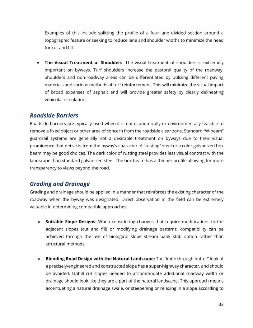
Examples of this include splitting the profile of a four-lane divided section around a
topographic feature or seeking to reduce lane and shoulder widths to minimize the need
for cut and fill.
• The Visual Treatment of Shoulders: The visual treatment of shoulders is extremely
important on byways. Turf shoulders increase the pastoral quality of the roadway.
Shoulders and non-roadway areas can be differentiated by utilizing different paving
materials and various methods of turf reinforcement. This will minimize the visual impact
of broad expanses of asphalt and will provide greater safety by clearly delineating
vehicular circulation.
Roadside Barriers Roadside barriers are typically used when it is not economically or environmentally feasible to
remove a fixed object or other area of concern from the roadside clear zone. Standard “W-beam”
guardrail systems are generally not a desirable treatment on byways due to their visual
prominence that detracts from the byway’s character. A “rusting” steel or a color galvanized box
beam may be good choices. The dark color of rusting steel provides less visual contrast with the
landscape than standard galvanized steel. The box beam has a thinner profile allowing for more
transparency to views beyond the road.
Grading and Drainage Grading and drainage should be applied in a manner that reinforces the existing character of the
roadway when the byway was designated. Direct observation in the field can be extremely
valuable in determining compatible approaches.
• Suitable Slope Designs: When considering changes that require modifications to the
adjacent slopes (cut and fill) or modifying drainage patterns, compatibility can be
achieved through the use of biological slope stream bank stabilization rather than
structural methods.
• Blending Road Design with the Natural Landscape: The “knife through butter” look of
a precisely-engineered and constructed slope has a super-highway character, and should
be avoided. Uphill cut slopes needed to accommodate additional roadway width or
drainage should look like they are a part of the natural landscape. This approach means
accentuating a natural drainage swale, or steepening or relaxing in a slope according to
34
the specific soil and rock materials found. In some cases this will require agreements with
abutting landowners since land outside the right-of-way may be involved. The result
however, can be more stable and less expensive to maintain, in addition to visual appeal.
Traffic Control Devices Traffic control devices, including signs and traffic barriers, should not detract from or overwhelm
the visual character of the natural or constructed landscape.
• Appropriate Traffic Control Devices: When considering traffic control devices,
compatibility can be achieved by selecting appropriately scaled signs, barriers, signal
boxes, and other devices designed to be no larger than necessary and to have minimal
visual contrast with the setting. For example, traffic signs at an intersection may be
smaller on an intersecting, lower-volume street than on the higher-volume cross street.
In terms of color, consider using dark colors in a forested environment for the device
frames or support structures as a means of reducing visual contrast.
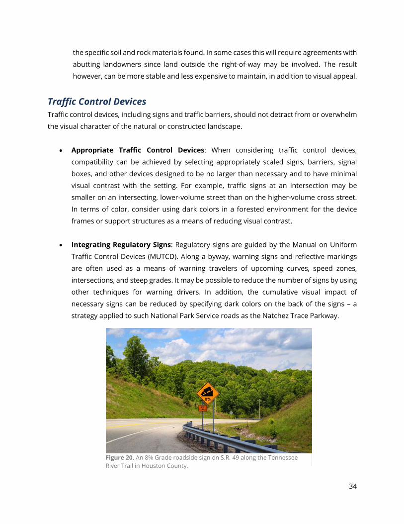
• Integrating Regulatory Signs: Regulatory signs are guided by the Manual on Uniform
Traffic Control Devices (MUTCD). Along a byway, warning signs and reflective markings
are often used as a means of warning travelers of upcoming curves, speed zones,
intersections, and steep grades. It may be possible to reduce the number of signs by using
other techniques for warning drivers. In addition, the cumulative visual impact of
necessary signs can be reduced by specifying dark colors on the back of the signs – a
strategy applied to such National Park Service roads as the Natchez Trace Parkway.
Figure 20. An 8% Grade roadside sign on S.R. 49 along the Tennessee River Trail in Houston County.
35
• Preserve, Maintain and Enhance: Where some choice in placement is available, traffic
control devices should be planned to preserve, maintain and enhance the character-
defining features of a scenic route. Signal control boxes, for example, should be placed in
a visually unobtrusive location. Likewise, traffic control devices should not impede
pedestrian or bicyclist use of the road corridor, where project goals seek to accommodate
these modes.
Utilities Utilities should be placed or relocated as to preserve or enhance the character of the byway. This
includes:
• Overhead and Underground Utilities: When work on overhead or underground utilities
is required, compatibility can be achieved by finding ways to minimize tree removal and
pruning requirements. Spacer bars can be specified that minimize the width of the
required clear area. These bars hold individual utility wires together as a single unit and
can reduce the right-of-way clearing requirements.
• Limitation of Underground Utilities: Requests for underground utilities are often made
for scenic byway. Underground placement of electric, telephone, and cable utilities can
be cost effective within towns and built up areas when coordinated with an ongoing
construction project. Problems can occur, however, if plans call for adjacent property
owners to upgrade their service connections at their own cost and if they are unwilling or
unable to do this. This is often the biggest constraint to underground placement of
utilities.
• Minimizing Visual Intrusion of Lines: It is also possible to minimize the visual intrusion
of overhead utility lines by moving utility poles to the rear of building lots, by adjusting
the location of poles to avoid having to compromise specimen trees or obstruct attractive
views, or by consolidation of lines on a single pole.
Landscaping Natural landscape features, such as native and traditional plant materials and tree cover, should
be preserved and maintained to support the traveler’s experience.

36
• Landscape as Screening Device: Landscape materials may serve as a useful screening
device to accomplish enhancement goals for the project.
• Landscape as Contributing Resource: In historic areas, street trees, stone walls, and
gardens are often associated with a listed site and should be preserved as a contributing
resource.
• Landscape Can Help to Trafic Calm: Landscape design may serve as an important tool
to accomplish both safety and traffic calming objectives. Street trees narrow the look and
feel of a roadway environment and increase the amount of “visual friction” along the
roadside leading drivers naturally to slow their operating speed.
• Native Plants can Address Erosion: Plantings of roadside grasses or native ground
covers may be used to address erosion problems on shallow slopes. Erosion problems
on steeper slopes should be addressed, where applicable by the planting of vines, ground
cover, or other lower-growing herbaceous or woody plants.
Figure 21. Consider natural plantings, similar to this TDOT pollinator meadow at the I-65 Welcome Center in Giles County, near Ardmore, TN.
37
Bridges and Small Structures If a bridge or small structure is considered a character-defining feature of the byway, it should
be preserved through maintenance and repair if possible. When a bridge must be replaced,
compatibility can be achieved by replacing the structure with what was originally there or by
reconstructing a bridge of a style that will not detract from the byway’s character.
• Replacing Bridge Design: For an example of a design detail that could enhance a
replacement bridge design, one might use the two-tube open-steel bridge rail developed
by the Wyoming DOT or a Texas Type C411, crash tested for urban streets with 45 MPH
speed limits or less. The Texas rail looks like open concrete rails with parapet wall
openings and is particularly useful for recreating the appearance of historic bridge rails.
The open steel bridge rail improves views to the waterway below.
• Visual Compatibility of Bridge Abutments: Greenways and trails are often an integral
part of a byway travel experience. Bridge abutments should be designed to be visually
compatible with the rock types and soil color of the adjacent streambank. Form liners can
be used on concrete walls to achieve an attractive design at less cost.
Signs Signs should be limited in number and size to be effective in communicating necessary
information while minimizing impact on the scenic and other values of the byway.
Guidelines for Compatible Signs:
1) Signs should be appropriately sized for the design speed of the road.
2) Signs should be consolidated where possible to minimize sign clutter and a proliferation of
sign poles.
3) Existing billboards should be considered by the byway organization for removal to improve
the scenic quality of the road.
4) New billboards are not allowed to be permitted along sections of roads designated as a Scenic
Highway or Tennessee Parkway.
5) Local planning and zoning officials should be included in project working groups to
coordinate project strategies for signage with local jurisdictions’ codes and enforcement
plans.
38
Lighting Street lighting, where installed along byways, should minimize glare and light pollution. Light
standards should be compatible with the character of the area being served and be scaled to
serve project goals, whether for pedestrian or vehicular use.
• Use of Street Lighting: Street lighting may be required along byways where necessary at
major access points, where there are security problems or poor vertical and horizontal
alignments or when traffic accident data or trafic volumes warrant street light installation.
• New and Replacement Street Lighting: New and replacement street lighting should be
scaled appropriately to meet project goals.
• Minimizing Light Pollution: New and replacement lighting along scenic byways should
use full cut-off optics luminaries to minimize light pollution.
Access Management Approval of access permits and decisions regarding requirement for acceleration or deceleration
lanes should be made carefully taking into consideration the importance of maintaining and
enhancing the character-defining features of the roadway. Access Management decisions should
be made in coordination with local planning officials as they affect local land use.
• Adjusting Acceleration/Deceleration Lanes: It may be desirable to shorten or narrow
acceleration and deceleration lanes to maintain character-defining features on the
roadway. Field observations may be very useful to determine if a reduced acceleration
and deceleration lane will suffice to meet project needs.
Roadside Enhancements The roadside enhancement projects that are likely to be constructed within TDOT rights-of-way
include measures that support the byway travel experience or make those portions of the byway
that no longer retain their intrinsic qualities more attractive. At a minimum, any work should not
overwhelm nor detract from the distinctive character of the roadway and should be compatible
with the existing road features in size, scale and proportion.
• Landscape and Signs: Landscaping and appropriately scaled signs can be used to create
a gateway to a community helping to establish the community’s sense of place.
39
• Interpretive Signage: Interpretive signage can be added to pull off areas to tell the
stories of the byway and provide information about the byway’s significance.
• Native Plant Materials: Where appropriate, the use of native plant materials in natural
planting patterns and historically traditional plant materials, especialy street trees, should
be emphasized to enhance the character of the roadway.
• Special Decorative Treatments: In urban areas, where possible, consideration should
be given to using special decorative treatments that reinforce the character of the area.
For example, higher qualitiy materials can be used such as brick or decorative stone work
for bridges, overpasses, and sidewalks, etc.
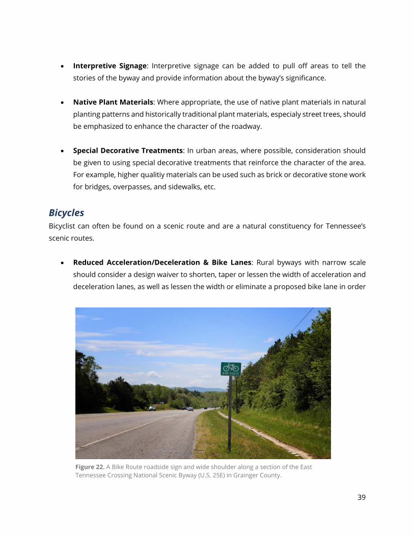
Bicycles Bicyclist can often be found on a scenic route and are a natural constituency for Tennessee’s
scenic routes.
• Reduced Acceleration/Deceleration & Bike Lanes: Rural byways with narrow scale
should consider a design waiver to shorten, taper or lessen the width of acceleration and
deceleration lanes, as well as lessen the width or eliminate a proposed bike lane in order
Figure 22. A Bike Route roadside sign and wide shoulder along a section of the East Tennessee Crossing National Scenic Byway (U.S. 25E) in Grainger County.
40
to maintain the byway’s narrow scale. Field observations may be useful to determine if a
reduced acceleration/deceleration lane width will meet bicyclist needs.
• Bike Conditions and Scenic Features: For those locations where bicycle
accommodations are a priority and conditions are poor, efforts should be made to both
improve bicycle conditions and maintain the character-defining features. For locations
that do not currently accommodate bicycles but are undergoing other roadway
improvements, the safe addition of bike features should be considered in the design
process.
• Other Bike Friendly Recommendations: Other recommendations include: reducing
lane widths if lanes are over 11’, which could allow for a wider shoulder or installation of
a bike lane; improve bicycle safety signage; stripe wide shoulders as a buffered bicycle
lane; and where possible, minimize center turn lanes.
Maintenance A byway should receive the level of maintenance necessary for safe public travel by auto, bicycle
and agriculture-related equipment while still preserving the character-defining features of the
route. The primary purpose of maintenance practices along state routes, including scenic byways,
is to maintain appropriate clear areas and sight distances, and remove rapidly decaying and dying
branches and trees to minimize the hazard of falling branches along the roadway and along utility
easements. Along byways, maintenance programs can also beautify the roadway and roadside
environment. Suggestions include:
• Adjust mowing practices to maximize flowering times of roadside wildflowers.
• Utilize TDOT’s Landscape Design Guidelines, or develop a byway-specific set of landscape
design guidelines that encourage revegetation to minimize mowing requirements.
• Encourage private citizens and residents within adjacent communities to adopt the
maintenance progam for planting areas at community entrances, medians, street tree
planting beds and roadside pull offs.
• Where feasible, when bridge repairs are necessary, they should be made in such a way as
to preserve the scenic and/or historic qualities of the structure.
41
• Where feasible, when a guardrail is replaced along a byway, it should be of a material that
enhances the roadway.
• Tree removal and/or pruning should be selective and follow good arboricultural practices
in order to maintain the character of the roadway. Selective tree cutting may be deemed
a necessary periodic maintenance technique to maintain the scenic vistas of a designated
route. Such a determination should be made in consultation with TDOT.
Management of Publicly Owned Land Publicly owned land adjacent to a byway should be managed in a manner that supports
preserving, maintaining and enhancing the byway. TDOT or other state agencies that own land
adjacent to the byway should consider retaining ownership to maintain the current condition of
the land. If TDOT or other state agencies dispose of such land, they should consider placing a
perpetual easement on the land prior to sale that will not allow uses or visual intrusions that
would degrade the character of the byway.
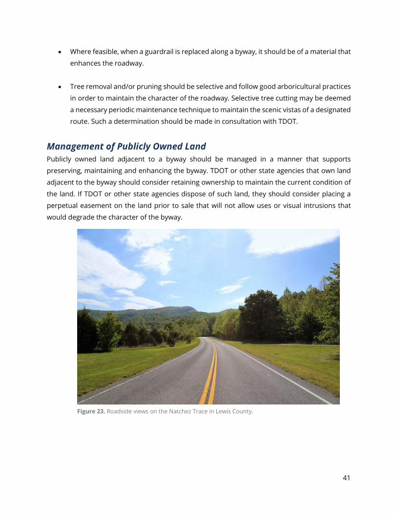
Figure 23. Roadside views on the Natchez Trace in Lewis County.
42
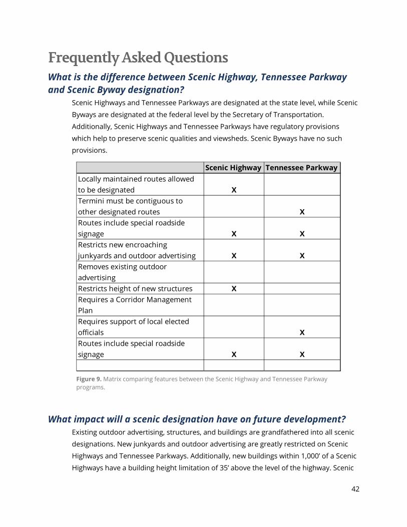
Frequently Asked Questions What is the difference between Scenic Highway, Tennessee Parkway and Scenic Byway designation?
Scenic Highways and Tennessee Parkways are designated at the state level, while Scenic
Byways are designated at the federal level by the Secretary of Transportation.
Additionally, Scenic Highways and Tennessee Parkways have regulatory provisions
which help to preserve scenic qualities and viewsheds. Scenic Byways have no such
provisions.
What impact will a scenic designation have on future development?
Existing outdoor advertising, structures, and buildings are grandfathered into all scenic
designations. New junkyards and outdoor advertising are greatly restricted on Scenic
Highways and Tennessee Parkways. Additionally, new buildings within 1,000’ of a Scenic
Highways have a building height limitation of 35’ above the level of the highway. Scenic
Scenic Highway Tennessee ParkwayLocally maintained routes allowed to be designated XTermini must be contiguous to other designated routes XRoutes include special roadside signage X XRestricts new encroaching junkyards and outdoor advertising X XRemoves existing outdoor advertisingRestricts height of new structures XRequires a Corridor Management PlanRequires support of local elected officials XRoutes include special roadside signage X X
Figure 9. Matrix comparing features between the Scenic Highway and Tennessee Parkway programs.
43
Byways are required to have a Corridor Management Plan which accounts for tourism
and economic development.
What is a scenic byway? A Scenic Byway is defined as any designated highway, street, road or route which
significantly features certain intrinsic qualities that should be preserved or enhanced.
Intrinsic qualities are the resources present along a byway that define its character,
interest and appeal. There are six types of intrinsic qualities: scenic, historic, natural,
cultural, archeological and recreational. Intrinsic qualities should be within the viewshed
of the byway and must relate or contribute to the distinctive character of the region.
What is a Corridor Management Plan? A Corridor Management Plan (CMP) is a guide for the future promotion, preservation
and enhancement of the scenic byway. The plan is a result of local governments,
community organizations and byway residents working together to establish goals and
objectives which they hope to achieve through designation. These goals may include the
promotion of tourism, protection of historic and natural resources, or preservation of
scenic views.
The CMP is not a document of new laws, regulations or ordinances, but instead is
composed of existing land use plans plus recommendations, by property owners and
stakeholders, used to assist in protecting and promoting the byway.
Who will implement and manage the Corridor Management Plan? The objectives of the Corridor Management Plan will be carried out by an underpinning
byway organization and appropriate local governments.
What are the community benefits of a scenic byway? A community’s benefits depend on the objectives established in the Corridor
Management Plan. For example, if a local government uses the designation to promote
tourism in the area, then residents may see an increase in economic development and a
decrease in taxes due to the generation of new tourism revenue. Or, if a community
decides to emphasize the protection of scenic and natural areas, land use ordinances
could be created to preserve the rural character of a byway and limit intrusion from
44
development. Scenic byway designation is a unique tool, in that it can be used to
achieve a wide variety of community goals.
How will the byway be funded? There are several possible funding sources, including Federal and State government
programs and private foundations. At the Federal level, National Scenic Byways Program
grants and Transportation Enhancement Program grants can be used to fund
improvements to the byway such as information kiosks, marketing brochures, scenic
overlooks, streetscaping plans and safety enhancements. The Tennessee departments
of Economic and Community Development and Tourism Development offer grants that
can used for byway-related projects, which are highlighted in the “Sustaining Byways”
section of this handbook.
What will the byway cost the sponsoring organization and/or local government?
It depends. The most obvious cost is time, which includes working on the application,
holding public meetings, and developing a Corridor Management Plan. As far as money
is concerned, the local government may need to provide a match for a grant to develop
planning documents, or to implement a project once designated. The local government
may also wish to contract out some elements of the designation, implementation and
maintenance processes. The extent of money and time needed is difficult to determine
since governments can take a more or less active part in developing, maintaining and
promoting a scenic byway.
Is there more maintenance required by local governments with a byway? Will a scenic byway route have improvements made to the roadway?
After designation, TDOT Maintenance staff will work with local jurisdictions to develop a
maintenance plan and schedule for the byway. The local governments, if they desire,
can choose to go beyond the routine TDOT maintenance and develop their own plan of
litter control, mowing, landscaping, etc. It is expected that the local government will
maintain any county or city streets along the byway. In fact, if local roads are to be
included in a byway, the governing jurisdiction must submit a resolution of support with
the application. Also, local governments must approve the Corridor Management Plan,
which should describe how the local government would maintain and operate the
45
byway. Byway sponsors can also work with TDOT’s Beautification Office and the Adopt-
A-Highway program to help enhance the appearance of designated roadways. In
addition, Scenic Byways may be allowed extra reviews from standard construction and
maintenance processes which would promote Context Sensitive Designs.
What kinds of property restrictions are required? Does the local government have to adopt comprehensive zoning?
The only property restriction is the prohibition of new billboards and junkyards along
routes designated as Federal Aid Primary, National Highway System, or Interstate.
Property along Scenic Highway routes are limited in terms of building height on new
construction. Existing billboards may remain.
The Corridor Management Plan is not a zoning plan but should reference any current
land use or community plans that would impact the byway corridor. If it is the
community’s goal to implement and/or enforce zoning of land use ordinances, then that
should be detailed in the Corridor Management Plan. Ideally, the community would
develop some type of control measure along the byway to further the goals of
enhancement, promotion and preservation.
How will living on a scenic route affect my property? Most likely, the byway will have no impact on an individual’s property. TDOT has only
one land use restriction, the prohibition of the construction of new billboards and
junkyards, which accompanies Tennessee Parkway and Scenic Highway designation.
Building heights are further defined for new construction along Scenic Highway routes.
This rule applies to Interstate, National Highway System, or Federal-Aid Primary routes.
Any other impacts could come from a byway’s Corridor Management Plan, which
residents help to develop. Since byways are often viewed as valuable community
resources, it is possible that living on a scenic byway will create greater sense of pride
for your land and may increase your property value.
Does designation as a scenic byway mean that TDOT will exercise Eminent Domain on my property?
No. Designation as a scenic byway in no way facilitates TDOT’s ability to acquire
property, nor does it increase likelihood of such an action.
46
Does designation as a scenic byway impact my ability to secure additional driveway permits or curb cuts/access points?
No. TDOT’s driveway permitting process is not altered by the route’s scenic byway
designation. However, byway designation is based on the route’s intrinsic qualities and
the protection of those qualities through local land use plans and zoning, which may
impact an individual’s ability to install new curb cuts or access points.
What happens if an easement, property, or access to property is needed for a scenic vista or for byway amenities?
If an easement, property, or access to property is needed for a scenic vista or other
byway project (such as the construction of physical amenities including turnouts and
parking areas, etc.) then federal-aid funds are used to purchase the access/property.
Next, a sponsor must follow the Uniform Relocation Assistance and Real Property
Acquisition Policies Act of 1970, more commonly known as the ‘Uniform Act’. This law
requires that certain procedures be followed in securing needed
easements/access/property in order to ensure that affected property owners are
treated fairly and equitably.
TDOT’s Right of Way Division maintains a Frequently Asked Questions page with
additional information, which can be accessed online at
https://www.tn.gov/content/dam/tn/tdot/right-of-way-
division/Frequently%20Asked%20Questions%207-12-18.pdf.
47
Appendices Appendix A: Glossary of Terms
Actual Award Date (AAD) – An estimated date that Federal Highways projects for
awarding funds for your project, if selected. The date could change due to
circumstances the State and Federal Highways may not be able to project.
Agriculture/Forestry – crops, wineries, vineyards, ranches, fisheries, old-growth and
reforested land.
All American Road (AAR) – Public roads that have been designated by the federal
government as satisfying National Scenic Byways criteria and have satisfied the
additional criteria and requirements for designation as All-American Roads pursuant to
the America’s Byway Program and its implementing legislation and regulations. To
receive this designation, a road must possess multiple intrinsic qualities that are
nationally significant and contain one-of-a-kind features that do not exist elsewhere.
America’s Byways® - The term used to describe and market the collection of 150
distinct roads designated by the U.S. Secretary of Transportation. America’s Byways
include All-American Roads and National Scenic Byways.
Authenticity -The quality of being genuine or real. It is something that is legitimate,
true, based on facts and not fabricated.
Byway – A roadway or waterway usually designated by its state DOT, state legislation, or
federal agency, that has tourist destinations within its corridor. It is a label used
throughout the nation to identify approximately 1,000 routes because of their special
attributes and locations as recognized by the States and Federal Government.
Byway Corridor – The roadway right-of-way, plus the adjacent area that reflects the
attributes of the byway. The width of the corridor can vary with different intrinsic
qualities.
48
Byway Story – A coordinated message that conveys the unique and authentic intrinsic
qualities of the byway. The narrative, either true or based on legend, about a roadway
or any of its attractions is designed to interest, amuse or instruct an audience.
Champion – A strong advocate with influence. Could be a person, group or
governmental body.
Color – overall color(s) of the basic components of the landscape (e.g., soil, rock,
vegetation, etc.) as they appear during the seasons or periods of high use. Key factors
are variety, contrast and harmony.
Confidence Marker – A sign that provides information to confirm that you are on the
correct roadway to your destination. It may note the number of miles or turns to take to
your destination.
Corridor – A road in a defined area on either side of the road, often an entire landscape
visible from the road. The distance the corrido extends from the road may vary,
depending on the intrinsic quality it represents.
Corridor Management Plan (CMP) – A plan that must be prepared for the scenic byway
corridor proposed for national designation. It should provide for the conservation and
enhancement of the byway’s intrinsic qualities as well as the promotion of tourism and
economic development.
Designation – The classification by a state and/or federal agency that defines a roadway
or waterway as a byway. It includes the acceptance of the byway’s written Corridor
Management Plan to preserve the byway’s integrity.
Destination Marketing Organization (DMO) – A Destination Marketing Organization
represents tourism sites and helps visitors make travel decisions. DMOs come in various
forms such as Tourism Bureau, Convention and Visitors Bureau or Chamber of
Commerce.
Discretionary Funds – The FHWA publishes a solicitation for applications or proposals
for a competitive funding program through a process based on established criteria and
available funding. The U.S. Secretary of Transportation or FHWA, if FHWA is delegated
49
the authority, may select an applicant to receive a discretionary grant award from
among all eligible applicants, may decide to make or not make an award based on the
application criteria, and may decide the amount of funding to be awarded, as allowed by
law.
Drivability – Driving safety, ease and pleasure as related to road standards (e.g., land
and shoulder width, traffic character, etc.)
Easements – Voluntary agreements in which a property owner agrees to certain
restrictions such as protecting agricultural lands, maintaining the qualities of a
viewshed, or preserving historic facades.
Federal Highway Administration (Federal Highways or FHWA) – The lead Federal
agency for the National Scenic Byway Program. FHWA has a Division Office in each State
that manages the program.
Federal Highway Beautification Act (FHBA) – The legislation which broadly protects
roadside quality and viewsheds through various encroaching occurrences, including the
signage on the Interstate and Federal-Aid Primary highway systems.
Interpretation – The process of sharing the importance of a place with others. ‘A
mission-based communication process that forges emotional and intellectual
connections between the interests of the audience and the meanings inherent in the
resource’ – National Association of Interpreters.
Intrinsic Quality – Feature that is representative, unique, irreplaceable or distinctly
characteristic of an area of byway corridor. They fall into one of six categories: scenic,
historic, archeological, recreational, cultural or natural.
Landform – Topography becomes more interesting as it gets steeper or more massive,
or more severely sculptured. Outstanding landforms may be monumental or
exceedingly artistic and subtle.
Metropolitan Planning Organization (MPO) – TDOT’s planning partner designated for
each urban area with a population of 50,000 or more, Members include both private
citizens and local government officials. An MPO addresses federal aid planning
50
mandates by producing local area transportation plans and transportation
improvement programs at least every four years, and by employing strategies that make
existing systems more efficient.
Modifications – Modifications in the landform, water, vegetation or addition of
structures that detract from or complement the scenic quality.
National Scenic Byway – A scenic highway which is designated by the federal
government as satisfying the criteria for a National Scenic Byway pursuant to Section
162 of Title 23 USC and any federal regulations and/or guidelines. To be designated, a
road must possess at least one of the six intrinsic qualities. The features contributing to
the distinctive characteristics of the corridor’s intrinsic qualities must possess regional
significance.
National Scenic Byway Program (NSBP) – Program managed and administered by
FHWA, as specified in law 23, U.S.C. 162.
Natural – This includes natural features such as geologic formations, wildlife sites,
waterfalls, lake basins, old-growth stands mountain meadows, etc.
Obligated – A formal commitment of a specified amount of funding for a particular
project. Obligations occur when the State, for State funds, or Federal awarding agency,
for Federal funds, executes a formal project agreement with the project recipient. Any
work conducted prior to formal notification of project authorization from TDOT to the
project sponsor will be considered ineligible for Federal funding.
Outdoor Advertising Device – Any outdoor sign, display, light, figure, painting, drawing,
message, plaque, poster, billboard or other thing which is designed, intended or used to
advertise or inform.
Paved – Hard surfaces such as concrete or bituminous asphalt.
Project Authorization – Receiving notice from the state and Federal Highways to
proceed with a project.
51
Public Participation – Receiving input, both through physical action or the exchange of
ideas and opinions by citizens, groups, organizations and businesses that have interest
in the results of the byway leaders’ decision-making process.
Reimbursements – The amount of funds Federal Highways has reimbursed States for
completed work on Byways projects.
Resources – Refers to byway assets, attributes, features and information found in the
environs of the byway corridor. Could refer to vistas, buildings sites, natural life, all of
which contribute to the intrinsic quality of the byway.
Rural Planning Organizations (RPO) – TDOT’s planning partner designed for a
geographical area with a population of less than 50,000. Members include both private
citizens and local government officials. An RPO addresses federal aid planning
mandates by producing local area transportation plans or transportation improvement
programs on an annual or biannual basis, or by employing other strategies that make
existing systems more efficient.
Scenic Highway Act – An act of the Tennessee General Assembly providing for the
designation of routes with restrictions on sign and junkyard encroachments.
Segmentation – Creation of a gap or sector along a byway route that has features that
are not compatible with the rest of the byway corridor. Segmentation is sometimes
done to accommodate the presence of an interstate or other physical barrier.
Stakeholder – A person, group, organization, government entity or business that has a
legitimate concern or interest in potential actions that could come from the byway
process.
Story Mapping - The graphic display of visuals, linked to descriptions, along a mapped
route that enables the traveler to gain deeper insights about a byway corridor’s
attributes.
Tactical Plan – This is the specific plan of action and implementation that addresses the
who, what, when and how of a CMP. It details how work will be organized, managed and
completed.
52
Tourism Oriented Directional Signs (TODS) – Tourism Oriented Directional Signs are
roadside guides provided by TDOT, with one or more panels that display the eligible
tourist destinations, businesses, services and activity facilities with directional arrows
and distance estimates.
Uniqueness/Scarcity – The relative scarcity of abundance of a particular unique scenic
resources or combination of features within the geographic region.
Vegetation – Forest, prairies, orchards, active farm cropland and tree farms. Consider
variety of patterns, form and texture created by plant life. Consider small scale
vegetation features which add striking and intriguing detail elements to the landscape.
Viewshed – The entire landscape visible from a particular point. In the case of a byway,
the viewshed is the entire landscape visible from any point along the road.
Virtual Tour – A simulation using video or still images of an existing location or route.
The display may involve other media elements such as sound effects, music, narration
and text.
Visitor Experience – The perceptions, feelings, reactions and memories a visitor has in
relationship with the surrounding environment.
Water – Rivers, lakes, waterfalls, rapids, marshes, canals and harbors. That ingredient
which adds movement or serenity to a scene. The degree to which water dominates the
scene.
Wayfinding – What the traveler does o maneuver along a byway. They use traffic signs,
byway signage, maps, brochures, landmarks and information systems to guide and
navigate to their desired destination.
Wayshowing – What the byway leadership does to provide appropriate signage and
guides for travelers to navigate with ease along the byway.
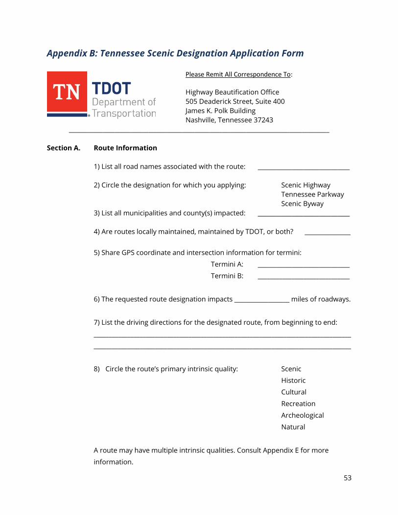
53
Appendix B: Tennessee Scenic Designation Application Form
Please Remit All Correspondence To: Highway Beautification Office 505 Deaderick Street, Suite 400 James K. Polk Building Nashville, Tennessee 37243
_____________________________________________________________________________________ Section A. Route Information
1) List all road names associated with the route: ______________________________ 2) Circle the designation for which you applying: Scenic Highway
Tennessee Parkway Scenic Byway
3) List all municipalities and county(s) impacted: ______________________________ 4) Are routes locally maintained, maintained by TDOT, or both? _______________
5) Share GPS coordinate and intersection information for termini:
Termini A: ______________________________
Termini B: ______________________________
6) The requested route designation impacts __________________ miles of roadways.
7) List the driving directions for the designated route, from beginning to end:
____________________________________________________________________________________
____________________________________________________________________________________
8) Circle the route’s primary intrinsic quality: Scenic
Historic
Cultural
Recreation
Archeological
Natural
A route may have multiple intrinsic qualities. Consult Appendix E for more
information.

54
Section B. Contact Information:
9) List contact information for the person nominating the route for scenic
designation:
____________________________________________________________________________________
____________________________________________________________________________________
Phone ( ) Email:
10) List the contact information for any governmental entity responsible in
nominating the route for scenic designation:
____________________________________________________________________________________
____________________________________________________________________________________
Phone ( ) Email:
Section C. Additional Information
11) List all entities and organizations who have expressed support for this scenic
designation: _____________________________________________________________
________________________________________________________________________________
12) Have all county and municipal governments listed in Section A been made
aware of this scenic request? Are they in support of the application? _________
________________________________________________________________________________
13) Is there anticipated opposition to the scenic designation? If so, explain _______
________________________________________________________________________________
14) Explain the primary reason for this scenic designation________________________
________________________________________________________________________________
55
15) How does this scenic designation compliment local scenic efforts (zoning/
historic preservation/ conservation, etc.)? _____________________________________
________________________________________________________________________________
16) What are the speed limits along the route? ___________________________________
________________________________________________________________________________
Section D. Attachments
17) Please attach to this form any of the following:
■ Route map showing all local governments, roads and termini
■ Resolutions from county and/or municipal governments endorsing the
scenic designation
■ Letters of support from all other parties endorsing the scenic
designation
For questions, or more information contact TDOT’s Highway Beautification Office at (615) 741-
2877, or [email protected]. In addition to the Scenic Handbook, information about
designations and programs can be found at https://www.tn.gov/tdot/environmental-
home/environmental-highway-beautification-office/beautification-national-scenic-byways.html.
56
Appendix C: Scenic Highway System Act of 1971 54-17-101 Short Title 54-17-102 Scenic highway system established. 54-17-103 Chapter Definitions. 54-17-104 Purposes, standards and objectives. 54-17-105 Eligibility for scenic highway designations – Requirements of designation
Comprehensive plan. 54-17-106 Proposal for scenic highway additions. (REPEALED) 54-17-107 Management – Promotion – Speed limit. 54-17-108 Advertising or junkyards prohibited on scenic highways – Authority of
commissioner to acquire. 54-17-109 Advertising permitted on scenic highways. 54-17-110 Removal or abatement of advertising structures and junkyards. 54-17-111 Trash dumping prohibited – Penalties. 54-17-112 Criminal sanctions. 54-17-113 Statutory conflict. 54-17-114 Designated scenic highways – Designated urban roads not to be impaired. 54-17-115 Building restrictions near scenic highways. 54-17-116 Effect of designation – Existing building permits – Construction of part. 54-17-101. Short title.
This part shall be known and may be cited as the “Scenic Highway System Act of 1971.”
54-17-102. Scenic highway system established.
(a) There is established a system of scenic highways for the state. (b) The system shall consist of those highways or roads or sections of the highways or roads that are so designated by the general assembly from time to time according to this part.
54-17-103. Chapter definitions.
In this chapter, unless the context otherwise requires:
(1) “Advertisement” means the outdoor display by painting, pasting, or affixing on any surface, a picture, emblem, word, figure, numeral, or lettering for the purpose of making anything known;
(2) “Scenic highway” means any highway, road, or sections of the highway or road designated as a scenic highway from time to time by the general assembly under this part; and
57
(3) “Sign, structure or advertising device” means any structure, post, tree, fence, rock, rigid or semirigid, with or without advertising displayed on the device, situated upon or attached to real property outdoors, primarily for the purpose of furnishing a background or support upon which advertisement may be affixed. A scenic byway is defined as any designated highway, street, road or route which significantly features certain intrinsic qualities that should be preserved or enhanced. Intrinsic qualities are the resources present along a byway that define its character, interest and appeal. There are six types of intrinsic qualities: scenic, historic, natural, cultural, archeological and recreational. Intrinsic qualities should be within the viewshed of the byway and must relate or contribute to the distinctive character of the region.
54-17-104. Purposes, standards and objectives.
The purposes of this part and its specific objectives and standards are to:
(1) Provide for the recovery and conservation of natural scenic beauty along designated scenic highways;
(2) Provide a safe and attractive environment for tourists and travelers to enjoy the scenic beauty of the state;
(3) Maximize the potential of little used and bypassed sections of highway;
(4) Return economic viability to distressed areas through the promotion of tourism; and
(5) Provide for preservation of routes of historical significance in urban and rural areas of the state.
54-17-105. Eligibility for scenic highway designation — Requirements of designation —
Comprehensive plan.
(a) Highways or thoroughfares that are maintained through the use of state or federal funds, and that are not needed for essential commercial or defense traffic, shall be eligible for designation as scenic highways, with exceptions the general assembly may from time to time consider necessary by designation in § 54-17-114.
(b) The designation of additions to the scenic highway system shall conform to the following criteria:
(1) Highways designated as scenic highways shall be components of a comprehensive system as outlined by a statewide scenic highway plan;
58
(2) Scenic highways shall travel through scenic, historic, geologic and pastoral areas of the state; (3) Highways should be designated to offer alternative travel routes to the high-speed, heavily traveled highways in the state;
(4) Designated highways shall provide the motorist with safe and relaxing routes of travel; and
(5) Scenic highways shall conform to an interconnected state scenic highway system, except in unusual situations whereby a highway is judged desirable for inclusion within the system because of unique scenic, historical, geologic or pastoral features.
(c) The commissioner of transportation shall, in accordance with the rules, regulations, policies and procedures of the state publications committee, prepare a comprehensive statewide scenic highway plan. In the preparation of this plan, the commissioner may consult as necessary with the department of environment and conservation, the department of agriculture, the department of economic and community development, the respective development districts across the state, and the Tennessee historical commission. The comprehensive plan shall include, but not be limited to, the following elements:
(1) The major routes of travel of tourists through the state so as to maximize the use of scenic highways by visitors in the state;
(2) The desirability of connecting components of the Tennessee outdoor recreation area system, prominent historic sites, major cities, federal recreation areas, scenic, geologic and pastoral areas, and other desirable areas by a scenic highway system;
(3) An interconnected system of scenic highways to enable the motorist to traverse the state of Tennessee on scenic roads;
(4) Certain theme scenic highways of historical significance that would be beneficial and educational for travel by the citizens of the state and its visitors;
(5) An administrative framework for marking and maintaining individual components of the Tennessee scenic highway system;
(6) A report on the fiscal impact of recommended highways, including funds necessary to initiate and maintain those highways;
(7) Recommended specific highways to be designated by the general assembly as scenic highways in compliance with § 54-17-104, and subdivisions (b)(1)-(4),
59
unless the general assembly by act designates specific exceptions to the requirements; and (8) A uniform program for signing, marking, and promoting the Tennessee scenic highway system.
54-17-107. Management — Promotion.
(a) Once the general assembly designates a highway or road or a portion of the highway or road as a scenic highway, the state or local agency having jurisdiction of the highway shall erect appropriate signs marking the designation, in accordance with the rules and regulations authorized to be promulgated, from funds appropriated by the general assembly for that purpose. The signs shall conform to standards established by the comprehensive statewide scenic highway plan; furthermore, the state or local agency having jurisdiction over the particular scenic highway shall provide proper marking, maintenance, and refuse removal services in connection with the highway.
(b) The department of tourist development shall study each newly designated scenic highway with the intention of including it in state and national promotional campaigns. In no instance may scenic highways be promoted through advertisement on any sign, structure or advertising device other than signs used for marking scenic highways by the department of transportation or local agency having jurisdiction.
(c) The department of economic and community development shall act to coordinate the efforts of local planning commissions, development districts, chambers of commerce, convention and visitors bureaus, and other federal, state, local, and private organizations in continuing the promotion and development of the scenic highway system.
(d) [Deleted by 2013 amendment.]
54-17-108. Advertising or junkyards prohibited on scenic highways — Authority of
commissioner to acquire.
(a) Whenever a road or highway has been designated part of the system, it is unlawful for any person to construct, use, operate or maintain any advertising structure or junkyard within two thousand feet (2,000′) of any road or highway that is a designated part of the system and that is located either outside the corporate limits of any city or town or at any place within a tourist resort county, as defined in § 42-1-301.
60
(b) The commissioner is authorized to acquire the advertising structure or junkyard by purchase, gift, or condemnation, and to pay just compensation for the removal of these structures and junkyards.
54-17-109. Advertising permitted on scenic highways.
The following advertising structures, or parts of the structures, are excepted from all provisions of § 54-17-108; however, as to advertising structures referred to in subdivisions (1)-(3) and (10), this exception shall not apply if the structures are larger than one hundred square feet (100 sq. ft.) or more frequent than one (1) sign of permissible size to every one thousand feet (1,000′) per road or highway frontage, except that an owner or lessee may display at least one (1) sale or rental sign of permissible size on each piece of property for sale or rent:
(1) Those constructed by the owner or lessee of a place of business or residence on land belonging to the owner or lessee and not more than one hundred feet (100′) from the place of business or residence, and relating solely to merchandise services or entertainment sold, produced, manufactured or furnished at the place of business or residence;
(2) Those constructed, erected, operated, used or maintained on any farm by the owner or lessee of the farm and relating solely to farm produce, merchandise, service or entertainment sold, produced, manufactured or furnished on the farm;
(3) Those upon real property posted or displayed by the owner or by the authority of the owner, stating that real property is for sale or rent;
(4) Official notices or advertisements posted or displayed by or under the direction of any public or court officer in the performance of the officer's official or directed duties, or by trustees under deeds of trust, deeds of assignment or other similar instruments;
(5) Danger or precautionary signs relating to the premises on which they are located, signs warning of the condition of or dangers of travel on a highway or road, erected or authorized by the department of transportation or applicable local agency or forest fire warning signs erected under authority of the department of agriculture and signs, notices or symbols erected by the United States government under the direction of the United States forest service;
(6) Signs solely to denote route to any city, town, village or historic place or shrine; (7) Notices of any railroad, bridge, ferry or other transportation or transmission company necessary for the direction or safety of the public;
61
(8) Signs, notices or symbols for the information of aviators as to location, directions and landings and conditions affecting safety in aviation; (9) Signs or notices placed at a junction of two (2) or more roads in the state highway system denoting only the distance or direction of a residence or subdivision; (10) Signs or notices erected or maintained on property giving the name of the owner, lessee or occupant of the premises; (11) Advertisements, advertising signs and advertising structures within the corporate limits of cities or towns; (12) Historical markers erected by duly constituted authorized public authorities; (13) Highway or road markers and signs erected or caused to be erected by duly authorized public authorities; (14) Signs erected on property warning the public against hunting and fishing or trespassing; (15)
(A) Except as provided in subdivision (15) (B), tourist oriented directional signs complying with chapter 5, part 13 of this title; (B)
(i) Subdivision (15)(A) shall not apply in counties having a population, according to the 1990 federal census or any subsequent federal census, of:
Not less than not more than 285,000 286,000 335,000 336,000
(ii) Subdivision (15)(A) shall only apply to a local government coming under its provisions after January 1, 1996, which by vote of its local legislative body chooses to apply subdivision (15)(A) to itself. Any tourist oriented directional signs program (TODS) authorized by the general assembly before January 1, 1996, shall continue in operation as originally authorized; and
(16) Directional signs of eight square feet (8 sq. ft.) or less for churches and nonprofit educational institutions. The signs must be located off the roadway or highway right-of-way.
54-17-110. Removal or abatement of advertising structures and junkyards.
62
(a) Any advertising structure or junkyard that is constructed or erected in violation of this part constitutes a public nuisance subject to abatement as provided by law.
(b) If the advertising structure or junkyard is declared a nuisance, it shall immediately be removed or abated and for that purpose the district attorney general or the district attorney general's duly appointed representative or any authorized representative of the state may enter onto private property without incurring any liability.
(c) The power of eminent domain may be utilized to remove existing advertising structures or junkyards from within one thousand feet (1,000′) of either side of designated Tennessee scenic highways.
(d) Should the state fail to enforce this section, any citizen or group of citizens may institute legal proceedings in a court of competent jurisdiction to require the state to enforce this section.
54-17-111. Trash dumping prohibited — Penalties.
Dumping or disposal of trash or refuse within five hundred feet (500′) of the highway right-of-way is specifically prohibited, and the usual penalties for littering state highways are doubled in the case of scenic highways.
54-17-112. Criminal sanctions.
(a) Any person, firm or corporation violating any provision of this part commits a Class C misdemeanor.
(b) Each and every day during which a violation of any provision of this part continues is deemed a separate offense.
(c) The attorney general and reporter, the district attorney general for the judicial district in which the violation occurs or is threatened, any state, municipal or county official or any adjacent or neighboring property owner who would be damaged by a violation of this part, in addition to other remedies provided by law, may institute injunction, mandamus, abatement or other appropriate action, actions or proceedings to prevent, enjoin or abate or remove the violation.
54-17-113. Statutory conflict. Whenever a provision of this part is found to be in conflict with a provision of any private or public act or local ordinance or code, the provision that establishes the higher standard for promotion and protection of the health, safety, and welfare of the people shall prevail; provided, that §§ 54-17-108 and
63
54-17-115 shall prevail in all applicable instances, any other provision of law to the contrary notwithstanding.
54-17-114. Designated scenic highways — Designated urban roads not to be impaired.
(a) For the purposes of this part, the following are initially designated scenic highways: (1) Class I — Urban Roads.
(A) That portion of Kingston Pike bearing the designation of State Highway 1 and United States Highway 11-70 in Knox County from its intersection with Concord Street and Neyland Drive in the City of Knoxville westward to the intersection of Kingston Pike with Lyons View Drive; (B) That portion of Lyons View Drive from its intersection with Kingston Pike, westward to its intersection with Northshore Drive; (C) That portion of United States Highway 70 South (West End Avenue) in Nashville from one hundred feet (100′) west of Elmington Avenue westward to its intersection with Ensworth Avenue; (D) All of Cherokee Boulevard located in the city of Knoxville; (E) Two Rivers Parkway in Davidson County; (F) Those portions of State Highway 100 in Davidson County from its intersection with Cheekwood Terrace south to its intersection with the Harpeth River and from its intersection with McCrory Lane south to its intersection with the South Harpeth River, and all of State Highway 251 in Davidson County, and that portion of State Highway 254 (Old Hickory Boulevard) from its intersection with State Highway 100 east to its intersection with Granny White Pike; (G) South Knoxville Boulevard between the relocated Sevier Avenue and Chapman Highway in Knoxville; (H) That segment of United States Highway 41 (Cummings Highway) in Hamilton County, beginning at the underpass at the current entrance to the Chattem property in St. Elmo, where that route is also designated as South Broad Street, running westward around the foot of Lookout Mountain to the railroad overpass on the east side of the Tiftonia business district;
64
(I) On or after April 16, 2015, that segment of State Route 169 (Middlebrook Road, which is commonly referred to as Middlebrook Pike) in Knox County from that route's intersection with Weisgarber Road in the City of Knoxville westward to its terminus at that route's intersection with Hardin Valley Road, but excluding any part of that segment of State Route 169 that has property fronting on the route that was zoned on April 16, 1996, with the commercial designation of CA, CB, or C3, or the industrial designation of I or I-3 under the Knox County or City of Knoxville zoning ordinances; provided, further, that the height restrictions on buildings imposed by, and any other restrictions as to property use contained in this part shall not apply to Parcel ID Numbers 106KC017, 106KC016, and 106DA008 in the City of Knoxville, Knox County, consisting of property on the south side of State Route 169 (Middlebrook Pike) and on the southwest side of Old Weisgarber Road; (J) That segment of State Route 385 (Nonconnah Parkway) in Shelby County from its intersection with United States Highway 72 to Interstate 240, but excluding any part of the segment of Route 385 that has property fronting on the route that is zoned on June 13, 1997, with the commercial designation of CL, CH or CP or the industrial designation of IL or IH under the Shelby County or city of Memphis zoning ordinances; and (K) All of State Route 475, Knoxville Parkway, a proposed project connecting I-40 / I-75 southwest of Knoxville to I-75 north of Knoxville, in Knox, Anderson and Loudon counties.
(2) Class II — Rural Roads.
(A) The portion of United States Highway 41 from its intersection with Interstate Highway 24 in Hamilton County westward through the Tennessee River Gorge, Jasper and on to the junction of that highway with State Highway 27 at Kimball (Marion County) and south along State Highway 27 to Interstate 24; (B) That portion of State Highway 66 from the French Broad River to Interstate 40, in Sevier County, except for the first two thousand one hundred fifty feet (2,150′) north of state bridge number 78-66-4.95 toward Interstate 40 in the north-bound lane only; (C) That portion of the Pellissippi Parkway (State Highway 162) in Knox County from its intersection with Interstate 40, to Melton Hill Lake; (D) The John Sevier Highway, in Knox County, from the Alcoa Highway (United States Highway 129) to the Chapman Highway (United States Highway 411/441);
65
(E) That portion of Northshore Drive in Knox County from its intersection with Lyons View Drive and Westland Drive west to Loudon County; provided, that the height restrictions on buildings imposed by § 54-17-115 shall not apply to that property along Northshore Drive within Knox County that is now or, subsequent to April 22, 2005, zoned “TC-1 (Town Center)”, or zoned C-6 from the east right-of-way line of Keller Bend Road at Northshore to the east right-of-way line of Pellissippi Parkway, or any similar zoning category, under the zoning ordinances of the city of Knoxville; (F) That portion of United States Highway 70 North beginning east of Cookeville at the Falling Water Bridge and extending approximately five (5) miles toward Monterey through the Dry Valley Community and ending at the Sand Springs Community; (G) That portion of State Highway 73 from the city of Maryville to the city of Townsend; (H) That portion of Westland Drive in Knoxville from its intersection with Northshore Drive to its intersection with Northshore Drive at the western end; (I) All of United States Highway 411 in Blount County and that portion of United States Highway 411 in Sevier County from the Blount County boundary to the intersection of United States Highway 411 with the Chapman Highway (United States Highway 441); (J) That portion of new State Highway 95 in Loudon and Blount counties from the Fort Loudon Dam to its intersection with United States Highway 129 at Morganton Road; (K) That portion of United States Highway 129 in Blount County, known as the 129 Bypass, from its intersection with State Highway 73 and Hall Road in the city of Alcoa to its intersection with United States Highway 411 in the city of Maryville; (L) All of Lyons Bend Road in Knox County; (M) That portion of Pittman Center Road from the intersection of Pittman Center Road with State Highway 73 East to the intersection of Pittman Center Road with United States Highway 411, east of Sevierville, but excluding those portions of Pittman Center Road that are within the boundaries, as of January 1, 1982, of incorporated municipalities;
66
(N) That portion of United States Highway 321 from the intersection of United States Highway 321 with Interstate 40 in Loudon County through Blount and Sevier counties to the intersection of United States Highway 321 with Interstate 40 in Cocke County, but excluding those portions of United States Highway 321 that are within the boundaries, as of January 1, 1982, of incorporated municipalities; (O) Hardin Valley Road in Knox County; (P) That portion of State Highway 58 in Hamilton County from the city limits of Chattanooga, as of July 1, 1987, to the Hamilton County boundary; (Q) That portion of Pellissippi Parkway (State Highway 162) that has been or will be constructed in Blount and Knox Counties after January 1, 1987; provided, that the height restrictions on buildings imposed by § 54-17-115 and sign restrictions referred to in § 54-17-109 that are applicable to § 54-17-109(1) and (10) shall not apply to that property along the Pellissippi Parkway within Knox County that is located between Kingston Pike and Interstate 75/40, all of which shall be regulated by the zoning ordinances and regulations of the appropriate county or municipal government; and provided, further, that the height restrictions on buildings imposed by § 54-17-115 shall not apply to that property along the Pellissippi Parkway within Knox County that is now or, subsequent to April 22, 2005, zoned “TC-1 (Town Center)”, or any similar zoning category, under the zoning ordinances of the city of Knoxville; and provided, further, that the height restrictions on buildings imposed by § 54-17-115 shall not apply to that property along Pellissippi Parkway within the corporate limits of the city of Alcoa, that is now or hereafter zoned for planned commercial zones or any similar zoning category under the zoning ordinances of the city of Alcoa; (R) All of the Natchez Trace Parkway, except for those portions within the boundaries of incorporated municipalities; (S) All of the Foothills Parkway, except for those portions within the boundaries of incorporated municipalities; (T) That portion of Alcoa Highway from the intersection of Alcoa Highway and Kingston Pike in Knox County to the intersection of Alcoa Highway and Singleton Station Road in Blount County; provided, that the height restrictions on buildings imposed by § 54-17-115 shall not apply to that property along Alcoa Highway being situated in District 9 in Knox County and Ward 24 of the City of Knoxville and being more particularly bounded and described as Tract 1, the University of Tennessee Medical Center, at
67
the intersection of Alcoa Highway and Cherokee Trail, and regulated by the zoning ordinances and regulations of the City of Knoxville; (U) The 9.141-mile segment of the Charles H. Coolidge Medal of Honor Highway beginning with its intersection with Signal Mountain Road to State Route 153; (V) The 9.33-mile segment of the Bill Carter Causeway beginning with its intersection with State Route 153 to north of Soddy Lake in Soddy-Daisy; (W) That portion of Highway 70 South from Murfreesboro to Woodbury; (X) All of United States Highway 27/State Route 29 in Rhea County; (Y) That portion of United States Highway 411 in Sevier County from the city limits of Sevierville to the Jefferson County boundary; (Z) That portion of United States Highway 411 in Sevier County from its intersection with United States Highway 441 at Newell Station west to the Blount County boundary; (AA) That segment of state route 416 in Sevier County from its intersection with United States Highway 411 to its intersection with United States Highway 321; (BB) That portion of State Highway 70 in Hawkins and Hancock counties from the intersection of State Highway 94 at Alumwell to the intersection of State Highway 33 at Kyles Ford, eleven and three tenths (11.3) miles; (CC) All of the highway known as The Trace located in Land Between the Lakes National Recreational Area in Stewart County; (DD) That portion of United States Highway 441 (Newfound Gap Road) in Sevier County from the city limits of the city of Gatlinburg to the Tennessee-North Carolina state line; and (EE) Powell Drive (State Route 131) in Knox County from the intersection with Clinton Highway (State Route 9) to the intersection with Emory Road.
(b) No state or local governmental entity, agency or department shall take any action that undermines the scenic and historical qualities of roads designated as scenic highways under subdivision (a)(1).
54-17-115. Building restrictions near scenic highways.
(a)
68
(1) The exposed portion of buildings constructed or erected on property located within one thousand feet (1,000′) of a scenic highway shall not exceed a height of thirty-five feet (35′) above the level of the highway on property located below the level of the highway, or a height of thirty-five feet (35′) above the ground line on property located above the level of the highway.
(2) The restriction on buildings shall apply to the scenic highway, notwithstanding the route being located inside or outside a municipality and notwithstanding any law or ordinance to the contrary.
(b) It is the legislative intent of this section, in part, that possession of a building permit at the time a road or highway is designated a scenic highway shall not allow any future construction based on that permit.
(c) (1) This section shall not apply to any building in existence at the time a road or highway is designated a part of the system. (2) Silos and buildings designed for agricultural use are exempted from the application of this section. (3) Any geographic area designated by state law and managed by a development authority authorized to promote and regulate technology-based economic development is exempt from the application of this section. (4) Section 54-17-113 shall not apply to this section.
54-17-116. Effect of designation — Existing building permits — Construction of part.
(a) Designation of a road or highway as a scenic highway under this part shall be presumed to arise from the public necessity and to protect the public good. (b) Section 54-17-115 shall become effective immediately upon designation of a road or highway as a scenic highway, the issuance of any building permit to the contrary notwithstanding, unless construction under the permit is so substantial as to render compliance with this part unfeasible. (c) The designation of scenic highways by the general assembly shall not give rise to actions for damages in any court of this state. This part shall be liberally construed to affect its remedial purposes.
69
Appendix D: Tennessee Parkway System Act 54-17-201 Short Title. 54-17-202 Legislative Findings. 54-17-203 Establishment and designation of parkway system. 54-17-204 Routes and promotional markers. 54-17-205 Existing outdoor advertising structures. 54-17-206 Advertising structures, junkyards, and trash dumping — Directional signs. 54-17-207 Additions to system — Designation powers of commissioner. 54-17-201. Short title.
This part shall be known and may be cited as the “Tennessee Parkway System Act.”
54-17-202. Legislative findings. (a) The state of Tennessee has abundant natural and scenic assets and recreational resources for the enjoyment of our citizens and those of other states. (b) Their general welfare will be enhanced by providing a road system that will promote the enjoyment of these assets and resources in accordance with this
54-17-203. Establishment and designation of parkway system.
(a) There is established a system of roads to be known as the Tennessee parkway system as designated in subsection (c). (b) Roads designated as part of the Tennessee parkway system shall retain their existing system designation. (c) The initial designation of the system is as follows:
(1) Beginning at the junction of State Route 73 and Interstate 40 in Loudon County and following along portions of State Routes 73, 33, 71 and 32 to Interstate 40 in Cocke County; (2) Beginning at the intersection of State Routes 73 and 115 in Maryville and following along portions or all of State Routes 115 and 168 to State Route 9 in Knoxville; (3) Beginning at the intersection of State Routes 71 and 73 near Pigeon Forge and following along portions of State Routes 71 and 66 to Interstate 40 in Sevier County;
70
(4) Beginning at the junction of State Route 57 and Interstate 240 in Memphis and following along portions of State Routes 57, 18, 15, 100, 22A, 22, 69, 142 and 128 to Interstate 65 in Giles County; (5) Beginning at the intersection of State Routes 100 and 22A in Chester County and following along portions of State Routes 22A and 22 to State Route 20 in Lexington; (6) Beginning at the intersection of State Routes 15 and 6 in Lawrenceburg and following along a portion of State Route 6 to the intersection of State Route 20; (7) Beginning at the junction of State Route 78 and Interstate 155 in Dyer County and following along portions of State Routes 78, 20, 104, 5 business, 77, 43, 1, 13, 48, 6, and 99 to Interstate 65 in Maury County; (8) Beginning at the junction of FAP route 2 and Interstate 40 in Shelby County and following along portions of FAP route 2, State Routes 3, 3 bypass, 78, 21, 22, 5, 54, 69, 76, 12, 112A, 11, 49 and 25 to Interstate 65 in Robertson County; (9) Beginning at the intersection of State Routes 20 and 69 in Decatur County and following along portions of State Routes 69 and 69 bypass to the intersection of State Route 76 in Henry County; (10) Beginning at the intersection of State Routes 6 and 99 in Maury County and following along portions of State Routes 6, 1 and 12 to the intersection of State Route 112A in Montgomery County; (11) Beginning at the junction of State Route 99 and Interstate 65 in Maury County and following along all or portions of State Routes 99, 11, 64, 10, 82, 55, 50, 15, 2, 56, 150, 27, and 8 to the intersection of State Route 27 in Spur in Hamilton County; (12) Beginning at the junction of State Route 27 and Interstate 24 in Marion County and following along portions of State Routes 27 and 2 to Interstate 24 in Hamilton County; (13) Beginning at the junction of State Route 25 and Interstate 65 in Robertson County and following along portions of State Routes 25, 10, 52, 42, 28, 29 and 63 to Interstate 75 in Campbell County;
71
(14) Beginning on State Route 10 at the Tennessee-Alabama state line in Lincoln County and following along portions of State Routes 10 and 1 to the intersection of State Route 25 in Trousdale County; (15) Beginning at the intersection of State Routes 10 and 96 in Rutherford County and following along portions of State Routes 96, 26, 1 and 61 to Interstate 40 in Roane County; (16) Beginning at the intersection of State Routes 27 and 28 in Marion County and following along portions of State Routes 28, 108 and 56 to Interstate 40 in Putnam County; (17) Beginning at the junction of State Route 56 and Interstate 40 in Putnam County and following along portions of State Routes 56 and 53 to the intersection of State Route 52 in Clay County; (18) Beginning at the intersection of State Routes 56 and 1 bypass in Warren County and following along portions of State Routes 1 bypass, 1, 30, and 101, county FAS route 601, portions of State Routes 28, 68, 29, and 33 to the intersection of State Route 73 in Blount County; (19) Beginning at the junction of State Route 40 bypass and Interstate 75 in Bradley County and following along all or portions of State Routes 40 bypass, 40 and 68 to the intersection of State Route 33 in Monroe County; (20) Beginning at the intersection of State Routes 68 and 165 in Monroe County and following along State Route 165 to the Tennessee-North Carolina state line; (21) Beginning at the junction of State Route 58 and Interstate 40 in Roane County and following along all or portions of State Routes 58, 95, 62 and 162 to Interstate 40 in Knox County; (22) Beginning at the intersection of State Route 62 and FAP 16 in Anderson County and following along all or portions of FAP 16 (Edgemore Road), State Routes 9 and 61 to Interstate 75 northeast of Clinton in Anderson County; (23) Beginning at the interchange of State Route 71 and Interstate 75 in Anderson County and following along portions of State Routes 71, 33 and 32 to the Tennessee-Virginia state line; (24) Beginning at the junction of State Route 32 and Interstate 40 in Cocke County and following along portions of State Routes 32, 9, 35, 34, 91, 37 and 1 to a junction with Interstate 81 in Sullivan County;
72
(25) Beginning at the intersection of State Routes 67 and 34 in Johnson County and following along a portion of State Routes 34 and 1 to Interstate 81 in Sullivan County; (26) Beginning at the intersection of State Routes 9 and 32 in Cocke County and following along portions of State Routes 32 and 1 to a junction with State Route 33 in Claiborne County; (27) Beginning on State Route 143 at the Tennessee-North Carolina state line in Carter County and following along all or portions of State Routes 143 and 37, county FAS route 723, State Routes 107, 36, 81 and 93 to Interstate 81 in Washington County; and (28) Beginning at the intersection of State Routes 36 and 81 in Erwin and following along portions of State Routes 36 and 81 to the Tennessee-North Carolina state line in Unicoi County.
54-17-204. Route and promotional markers.
(a) The department of transportation is directed to erect suitable route and promotional markers for the parkway system. (b) The cost of erecting the markers shall be paid from appropriations made to the department of transportation.
54-17-205. Existing outdoor advertising structures.
(a) All outdoor advertising structures issued a permit prior to April 27, 1982, shall be valid.
(b) These structures shall be able to be maintained, repaired, reconstructed or constructed according to the original application for the outdoor advertising permit.
54-17-206. Advertising structures, junkyards, and trash dumping — Directional signs.
(a)
(1) Part 1 of this chapter regarding advertising structures, junkyards and trash dumping applies to the Tennessee parkway system. If a conflict exists between this part and part 1 of this chapter regarding advertising structures, junkyards and trash dumping, due to a road having been designated as being on both the scenic highway system pursuant to part 1 of this chapter and the parkway
73
system pursuant to this part, then part 1 of this chapter shall prevail. It is the intent of the general assembly that nothing contained in this subdivision (a)(1) shall be construed as having any retroactive force or taking away any vested right or be applied to any contractual obligation. (2) Subdivision (a)(1) shall not apply to those parts of the system lying within any comprehensively zoned area, unless otherwise provided by the zoning regulations and within one-half (½) mile of any section of the parkway system where it crosses an interstate highway system. (3) The commissioner of transportation may authorize the construction of advertising structures described in § 54-17-109(1) no larger than five hundred square feet (500 sq. ft.) and the construction and maintenance of signs that do not exceed eight square feet (8 sq. ft.) in area for nonprofit service clubs, charitable associations or religious services in accordance with criteria contained in rules and regulations that the commissioner is authorized to promulgate. (4) The commissioner may also authorize the construction of advertising structures of the size specified in subdivision (a)(3) for business establishments located within five (5) miles of a parkway route that provide services to persons traveling on that route. This subdivision (a)(4) shall apply only to that portion of Highway 79 located west and south of the Tennessee River that is in the Tennessee parkway system. (b) All business establishments shall be entitled to erect and maintain two (2) directional signs of less than seventy-five square feet (75 sq. ft.) indicating the location of their business premises, with the spacing and zoning required by present laws.
54-17-207. Additions to system — Designation powers of commissioner.
Additions to the parkway system shall be part of the system of state highways, and the commissioner of transportation shall have the same powers set forth in §§ 54-5-101 and 54-5-102 with regard to designating the parkway system as the commissioner has to designate the system of state highways.
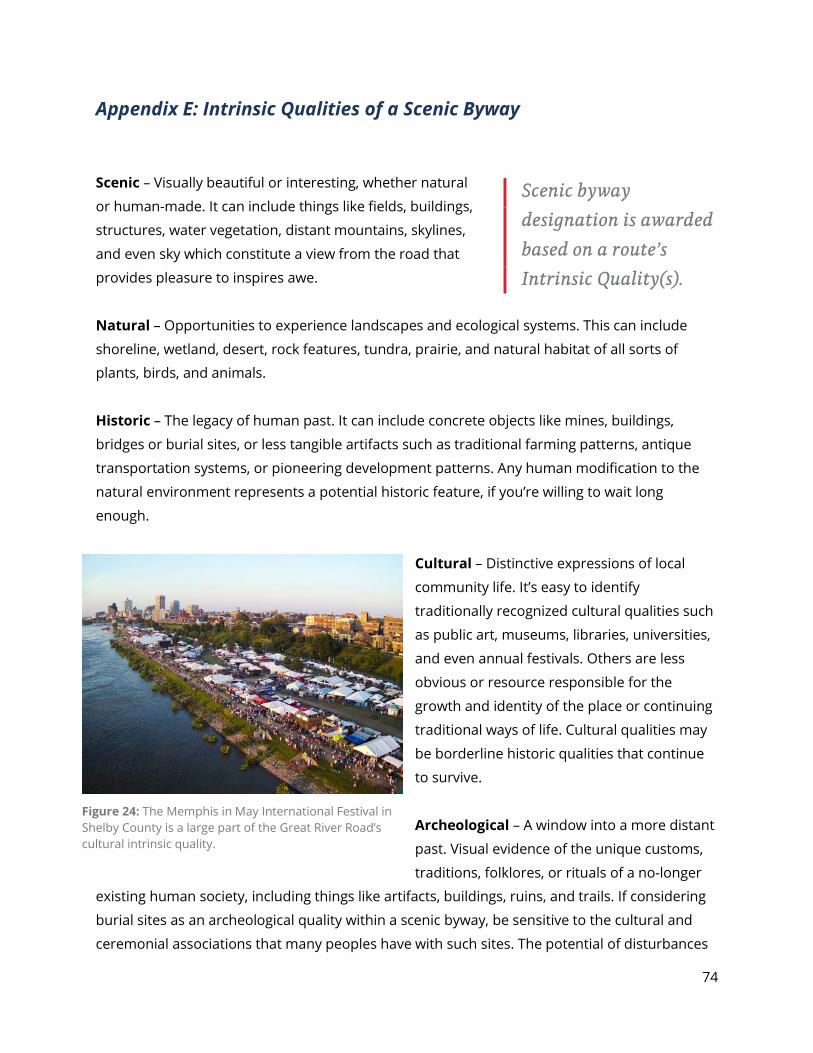
74
Appendix E: Intrinsic Qualities of a Scenic Byway
Scenic – Visually beautiful or interesting, whether natural
or human-made. It can include things like fields, buildings,
structures, water vegetation, distant mountains, skylines,
and even sky which constitute a view from the road that
provides pleasure to inspires awe.
Natural – Opportunities to experience landscapes and ecological systems. This can include
shoreline, wetland, desert, rock features, tundra, prairie, and natural habitat of all sorts of
plants, birds, and animals.
Historic – The legacy of human past. It can include concrete objects like mines, buildings,
bridges or burial sites, or less tangible artifacts such as traditional farming patterns, antique
transportation systems, or pioneering development patterns. Any human modification to the
natural environment represents a potential historic feature, if you’re willing to wait long
enough.
Cultural – Distinctive expressions of local
community life. It’s easy to identify
traditionally recognized cultural qualities such
as public art, museums, libraries, universities,
and even annual festivals. Others are less
obvious or resource responsible for the
growth and identity of the place or continuing
traditional ways of life. Cultural qualities may
be borderline historic qualities that continue
to survive.
Archeological – A window into a more distant
past. Visual evidence of the unique customs,
traditions, folklores, or rituals of a no-longer
existing human society, including things like artifacts, buildings, ruins, and trails. If considering
burial sites as an archeological quality within a scenic byway, be sensitive to the cultural and
ceremonial associations that many peoples have with such sites. The potential of disturbances
Scenic byway designation is awarded based on a route’s Intrinsic Quality(s).
Figure 24: The Memphis in May International Festival in Shelby County is a large part of the Great River Road’s cultural intrinsic quality.

75
or even interpretation may be unacceptable in some cases, so proceed with caution and seek
out good advice as you go.
Recreational – Features that are traditionally associated with outdoor recreation. This can
include traditional nature-based activities like canoeing or camping but can be more as well.
Recreational resources that are currently used by your community may be better
acknowledged and conserved in tandem with a scenic byway designation.
76
Appendix F: Federal Authorizing Legislation Title 23, Section 162 of the United States Code describes creation of the National Scenic Byways program. This legislation was most recently amended in 2005 upon passage of the Safe, Accountable, Flexible, and Efficient Transportation Equity Act - A Legacy for Users (SAFETEA-LU).
SAFETEA-LU SEC. 1101. AUTHORIZATION OF APPROPRIATIONS
(b) IN GENERAL.—The following sums are authorized to be appropriated out of the Highway Trust Fund (other than the Mass Transit Account): . . .
(12) NATIONAL SCENIC BYWAYS PROGRAM.—For the national scenic Byways program under section 162 of such title— A. $26,500,000 for fiscal year 2005; B. $30,000,000 for fiscal year 2006; C. $35,000,000 for fiscal year 2007; D. $40,000,000 for fiscal year 2008; and E. $43,500,000 for fiscal year 2009.
SEC. 1803. AMERICA’S BYWAYS RESOURCE CENTER
(a) IN GENERAL.—The Secretary shall allocate funds made available to carry out this section to the America’s Byways Resource Center established pursuant to section 1215(b)(1) of the Transportation Equity Act for the 21st Century (112 Stat. 209). UNITED STATES CODE TITLE 23 - Highways § 162. National scenic byways program
(a) DESIGNATION OF ROADS (1) IN GENERAL.—The Secretary shall carry out a national scenic byways program
that recognizes roads having outstanding scenic, historic, cultural, natural, recreational, and archaeological qualities by designating the roads as– A. National Scenic Byways; B. All American Roads; or C. America’s Byways.
(2) CRITERIA.—The Secretary shall designate roads to be recognized under the national scenic byways program in accordance with criteria developed by the Secretary.
(3) NOMINATION.— A. IN GENERAL.–To be considered for a designation, a road must be nominated by
a State, an Indian tribe, or a Federal land management agency and must first be designated as a State scenic byway, an Indian tribe scenic byway, or, in the case of a road on Federal land, as a Federal land management agency byway.
B. NOMINATION BY INDIAN TRIBES.—An Indian tribe may nominate a road as a National Scenic Byway, an All-American Road, or one of America’s Byways under para- graph (1) only if a Federal land management agency (other than the Bureau of Indian Affairs), a State, or a political subdivision of a State does not have— i. jurisdiction over the road; or ii. responsibility for managing the road.
77
C. SAFETY.—An Indian tribe shall maintain the safety and quality of roads nominated by the Indian tribe under subparagraph (A).
(4) RECIPROCAL NOTIFICATION.—States, Indian tribes, and Federal land management agencies shall notify each other regarding nominations made under this subsection for roads that— A. are within the jurisdictional boundary of the State, Federal land management
agency or Indian tribe; or B. directly connect to roads which the State, Federal land management agency or
Indian tribe is responsible.
(b) GRANTS AND TECHNICAL ASSISTANCE. (b) IN GENERAL.—The Secretary shall make grants and provide technical assistance to
States and Indian tribes to— (1) implement projects on highways designated as—
A. National Scenic Byways; B. All American Roads; C. America’s Byways; D. State Scenic Byways; or E. Indian tribe scenic byways; and
(2) plan, design, and develop a State scenic or Indian tribe byway program. (c) PRIORITIES.—In making grants, the Secretary shall give priority to
(1) each eligible project that is associated with a highway that has been designated as a National Scenic Byway, All American Road, or 1 of America’s Byways; and that is consistent with the Corridor Management Plan for the byway;
(2) each eligible project along a State or Indian tribe scenic byway that is consistent with the Corridor Management Plan for the byway, or is intended to foster the development of such a plan, and is carried out to make the byway eligible for designation as— A. National Scenic Byways; B. All American Roads; or C. America’s Byways; and
(3) each eligible project that is associated with the development of a State or Indian tribe
scenic byway program.
(c) ELIGIBLE PROJECTS.—The following are projects that are eligible for Federal assistance under this section:
(1) An activity related to the planning, design, or development of a State or Indian tribe scenic
byway program. (2) Development and implementation of a Corridor Management Plan to maintain the
scenic, historical, recreational, cultural, natural, and archaeological characteristics of a byway corridor while providing for accommodation of increased tourism and development of related amenities.
(3) Safety improvements to a State scenic byway, Indian tribe scenic byway, National Scenic Byway, All American Road, or one of America’s Byways to the extent that the improvements are necessary to accommodate increased traffic and changes in the types of vehicles using the highway as a result of the designation as a State scenic byway, Indian tribe scenic byway, National Scenic Byway, All American Road, or one of America’s Byways.
78
(4) Construction along a scenic byway of a facility for pedestrians and bicyclists, rest area, turnout, highway shoulder improvement, overlook, or interpretive facility.
(5) An improvement to a scenic byway that will enhance access to an area for the purpose of
recreation, including water related recreation. (6) Protection of scenic, historical, recreational, cultural, natural, and archaeological
resources in an area adjacent to a scenic byway.
(7) Development and provision of tourist information to the public, including interpretive information about a scenic byway.
(8) Development and implementation of a scenic byway marketing program.
(d) LIMITATION—The Secretary shall not make a grant under this section for any project that would not protect the scenic, historical, recreational, cultural, natural, and archaeological integrity of a highway and adjacent areas.
(e) SAVINGS CLAUSE—The Secretary shall not withhold any grant or impose any requirement on a State or Indian tribe as a condition of providing a grant or technical assistance for any scenic byway unless the requirement is consistent with the authority provided in this chapter.
(f) FEDERAL SHARE—The Federal share of the cost of carrying out a project under this section shall be 80 percent, except that, in the case of any scenic byway project along a public road that pro- vides access to or within Federal or Indian land, a Federal may use funds authorized for use by the agency as the non-Federal share.
§ 131. Control of outdoor advertising (s) SCENIC BYWAY PROHIBITION.—If a State has a scenic byway program, the State may not allow the erection along any highway on the Interstate System or Federal-aid primary system which before, on, or after the effective date of this subsection, is designated as a scenic byway under such program of any sign, display, or device which is not in conformance with subsection (c) of this section. Control of any sign, display, or device on such a highway shall be in accordance with this section. In designating a scenic byway for purposes of this section and section 1047 of the Intermodal Surface Transportation Efficiency Act of 1991, a State may exclude from such designation any segment of a highway that is inconsistent with the State’s criteria for designating State scenic byways. Nothing in the preceding sentence shall preclude a State from signing any such excluded segment, including such segment on a map, or carrying out similar activities, solely for purposes of system continuity. (a) Effective control means that such signs, displays, or devices after January 1, 1968, if
located with- in six hundred and sixty feet of the right-of-way and, on or after July 1, 1975, or after the expiration of the next regular session of the State legislature, whichever is later, if located beyond six hundred and sixty feet of the right-of-way, located outside of urban areas, visible from the main traveled way of the system, and erected with the purpose of their message being read from such main traveled way, shall, pursuant to this section be limited to:
(1) directional and official signs and notices, which signs and notices shall include, but not be limited to, signs aw, which shall conform to national standards hereby authorized to be promulgated by the Secretary hereunder, which standards shall contain provisions
concerning lighting, size, number, and spacing of signs, and such other requirements as may be appropriate to implement this section,
79
(2) signs, displays, and devices advertising the sale or lease of property upon which they are
located, (3) signs, displays, and devices, including those which may be changed at reasonable
intervals by electronic process or by remote control, advertising activities conducted on the property on which they are located,
(4) signs lawfully in existence on October 22, 1965, deter-mined by the State, subject to the approval of the Secretary, to be landmark signs, including signs on farm structures or natural surfaces, of historic or artistic significance the preservation of which would be consistent with the purposes of this section, and
(5) signs, displays, and devices advertising the distribution by nonprofit organizations of free coffee to individuals traveling on the Interstate System or the primary system. For the purpose of this subsection, the term “free coffee” shall include coffee for which a donation may be made, but is not required.
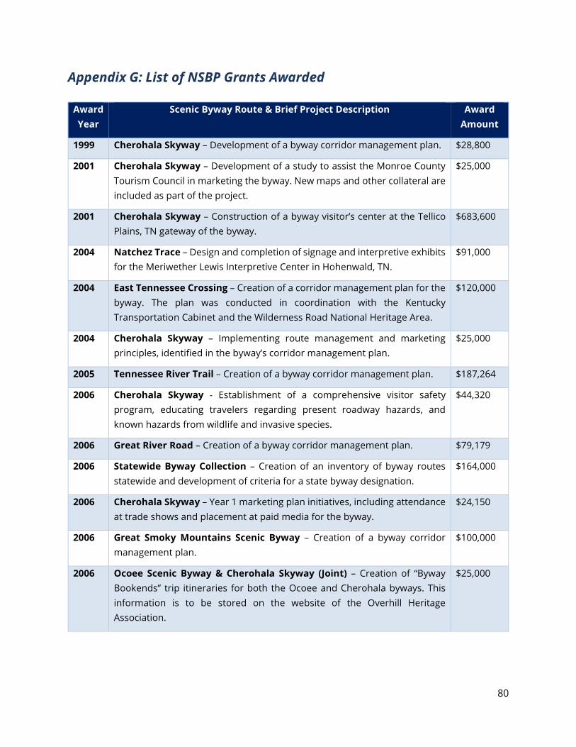
80
Appendix G: List of NSBP Grants Awarded
Award Year
Scenic Byway Route & Brief Project Description Award Amount
1999 Cherohala Skyway – Development of a byway corridor management plan. $28,800
2001 Cherohala Skyway – Development of a study to assist the Monroe County Tourism Council in marketing the byway. New maps and other collateral are included as part of the project.
$25,000
2001 Cherohala Skyway – Construction of a byway visitor’s center at the Tellico Plains, TN gateway of the byway.
$683,600
2004 Natchez Trace – Design and completion of signage and interpretive exhibits for the Meriwether Lewis Interpretive Center in Hohenwald, TN.
$91,000
2004 East Tennessee Crossing – Creation of a corridor management plan for the byway. The plan was conducted in coordination with the Kentucky Transportation Cabinet and the Wilderness Road National Heritage Area.
$120,000
2004 Cherohala Skyway – Implementing route management and marketing principles, identified in the byway’s corridor management plan.
$25,000
2005 Tennessee River Trail – Creation of a byway corridor management plan. $187,264
2006 Cherohala Skyway - Establishment of a comprehensive visitor safety program, educating travelers regarding present roadway hazards, and known hazards from wildlife and invasive species.
$44,320
2006 Great River Road – Creation of a byway corridor management plan. $79,179
2006 Statewide Byway Collection – Creation of an inventory of byway routes statewide and development of criteria for a state byway designation.
$164,000
2006 Cherohala Skyway – Year 1 marketing plan initiatives, including attendance at trade shows and placement at paid media for the byway.
$24,150
2006 Great Smoky Mountains Scenic Byway – Creation of a byway corridor management plan.
$100,000
2006 Ocoee Scenic Byway & Cherohala Skyway (Joint) – Creation of “Byway Bookends” trip itineraries for both the Ocoee and Cherohala byways. This information is to be stored on the website of the Overhill Heritage Association.
$25,000
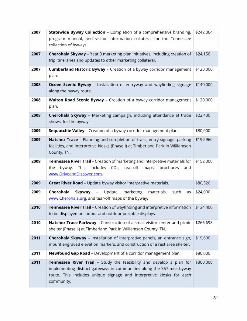
81
2007 Statewide Byway Collection – Completion of a comprehensive branding, program manual, and visitor information collateral for the Tennessee collection of byways.
$242,064
2007 Cherohala Skyway – Year 3 marketing plan initiatives, including creation of trip itineraries and updates to other marketing collateral.
$24,150
2007 Cumberland Historic Byway – Creation of a byway corridor management plan.
$120,000
2008 Ocoee Scenic Byway – Installation of entryway and wayfinding signage along the byway route.
$140,000
2008 Walton Road Scenic Byway – Creation of a byway corridor management plan.
$120,000
2008 Cherohala Skyway – Marketing campaign, including attendance at trade shows, for the byway.
$22,400
2009 Sequatchie Valley – Creation of a byway corridor management plan. $80,000
2009 Natchez Trace – Planning and completion of trails, entry signage, parking facilities, and interpretive kiosks (Phase I) at Timberland Park in Williamson County, TN.
$199,960
2009 Tennessee River Trail – Creation of marketing and interpretive materials for the byway. This includes CDs, tear-off maps, brochures and www.DriveandDiscover.com.
$152,000
2009 Great River Road – Update byway visitor interpretive materials. $80,320
2009 Cherohala Skyway – Update marketing materials, such as www.Cherohala.org, and tear-off maps of the byway.
$24,000
2010 Tennessee River Trail – Creation of wayfinding and interpretive information to be displayed on indoor and outdoor portable displays.
$134,400
2010 Natchez Trace Parkway – Construction of a small visitor center and picnic shelter (Phase II) at Timberland Park in Williamson County, TN.
$266,698
2011 Cherohala Skyway – Installation of interpretive panels, an entrance sign, mount engraved elevation markers, and construction of a rest area shelter.
$19,800
2011 Newfound Gap Road – Development of a corridor management plan. $80,000
2011 Tennessee River Trail – Study the feasibility and develop a plan for implementing distinct gateways in communities along the 357-mile byway route. This includes unique signage and interpretive kiosks for each community.
$300,000
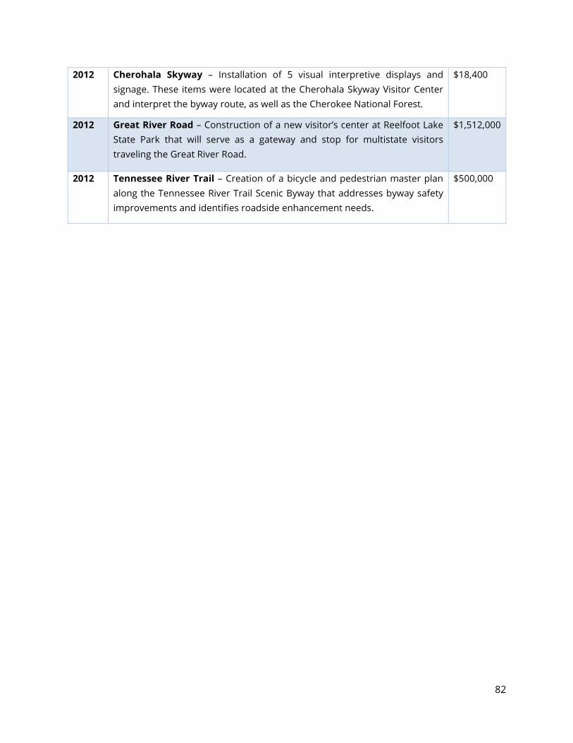
82
2012 Cherohala Skyway – Installation of 5 visual interpretive displays and signage. These items were located at the Cherohala Skyway Visitor Center and interpret the byway route, as well as the Cherokee National Forest.
$18,400
2012 Great River Road – Construction of a new visitor’s center at Reelfoot Lake State Park that will serve as a gateway and stop for multistate visitors traveling the Great River Road.
$1,512,000
2012 Tennessee River Trail – Creation of a bicycle and pedestrian master plan along the Tennessee River Trail Scenic Byway that addresses byway safety improvements and identifies roadside enhancement needs.
$500,000
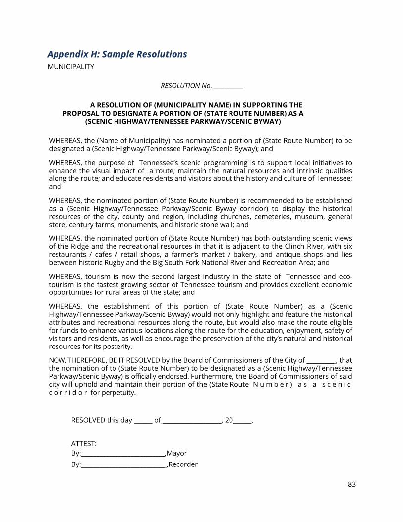
83
Appendix H: Sample Resolutions MUNICIPALITY
RESOLUTION No. ___________
A RESOLUTION OF (MUNICIPALITY NAME) IN SUPPORTING THE PROPOSAL TO DESIGNATE A PORTION OF (STATE ROUTE NUMBER) AS A
(SCENIC HIGHWAY/TENNESSEE PARKWAY/SCENIC BYWAY)
WHEREAS, the (Name of Municipality) has nominated a portion of (State Route Number) to be designated a (Scenic Highway/Tennessee Parkway/Scenic Byway); and
WHEREAS, the purpose of Tennessee’s scenic programming is to support local initiatives to enhance the visual impact of a route; maintain the natural resources and intrinsic qualities along the route; and educate residents and visitors about the history and culture of Tennessee; and
WHEREAS, the nominated portion of (State Route Number) is recommended to be established as a (Scenic Highway/Tennessee Parkway/Scenic Byway corridor) to display the historical resources of the city, county and region, including churches, cemeteries, museum, general store, century farms, monuments, and historic stone wall; and
WHEREAS, the nominated portion of (State Route Number) has both outstanding scenic views of the Ridge and the recreational resources in that it is adjacent to the Clinch River, with six restaurants / cafes / retail shops, a farmer’s market / bakery, and antique shops and lies between historic Rugby and the Big South Fork National River and Recreation Area; and
WHEREAS, tourism is now the second largest industry in the state of Tennessee and eco-tourism is the fastest growing sector of Tennessee tourism and provides excellent economic opportunities for rural areas of the state; and
WHEREAS, the establishment of this portion of (State Route Number) as a (Scenic Highway/Tennessee Parkway/Scenic Byway) would not only highlight and feature the historical attributes and recreational resources along the route, but would also make the route eligible for funds to enhance various locations along the route for the education, enjoyment, safety of visitors and residents, as well as encourage the preservation of the city’s natural and historical resources for its posterity.
NOW, THEREFORE, BE IT RESOLVED by the Board of Commissioners of the City of _________ , that the nomination of to (State Route Number) to be designated as a (Scenic Highway/Tennessee Parkway/Scenic Byway) is officially endorsed. Furthermore, the Board of Commissioners of said city will uphold and maintain their portion of the (State Route N u m b e r ) a s a s c e n i c c o r r i d o r for perpetuity.
RESOLVED this day ______ of ___________________, 20______.
ATTEST: By:___________________________,Mayor By:___________________________ ,Recorder
84
COUNTY RESOLUTION No. ____ of 20_____
A RESOLUTION OF (COUNTY NAME) OF SUPPORTING THE PROPOSAL TO DESIGNATE A PORTION OF (STATE ROUTE
NUMBER) AS A (SCENIC HIGHWAY/TENNESSEE PARKWAY/SCENIC BYWAY)
WHEREAS, the (Name of County) has nominated a portion of (State Route Number) to be designated a (Scenic Highway/Tennessee Parkway/Scenic Byway); and
WHEREAS, the purpose of the Tennessee’s scenic programming is to support local initiatives to enhance the visual impact of a route; maintain the natural resources and qualities along the route; and educate residents and visitors about the history and culture of Pennsylvania; and
WHEREAS, the nominated portion of (State Route Number) is recommended to be established as a (Scenic Highway/Tennessee Parkway/Scenic Byway corridor) to display the historical resources of the county and region, including churches, cemeteries, museum, general store, century farms, monuments, and historic stone wall; and
WHEREAS, the nominated portion of (State Route Number) has both outstanding scenic views of the Ridge and the recreational resources in that it is adjacent to the Clinch River, with six restaurants / cafes / retail shops, a farmer’s market / bakery, and antique shops and lies between historic Rugby and the Big South Fork National River and Recreation Area; and
WHEREAS, tourism is now the second largest industry in the state of Tennessee and eco-tourism is the fastest growing sector of Tennessee tourism and provides excellent economic opportunities for rural areas of the state; and
WHEREAS, the establishment of this portion of (State Route Number) as a (Scenic Highway/Tennessee Parkway/Scenic Byway) would not only highlight and feature the historical attributes and recreational resources along the route, but would also make the route eligible for funds to enhance various locations along the route for the education, enjoyment, safety of visitors and residents, as well as encourage the preservation of the County’s natural and historical resources for its posterity.
NOW, THEREFORE, BE IT RESOLVED by the Board of Commissioners of the County of_______, and it is hereby resolved, that the Commission supports the nomination to designate (State Route Number) as a (Scenic Highway/Tennessee Parkway/Scenic Byway).
ADOPTED this _______ day of_________________ , 20_______ .
ATTEST: (Insert County Name) Board of Commissioners
By: ___________,(County Mayor/Executive)
By:___________, Clerk
85
Appendix I: Sample Letters of Support SAMPLE LETTER OF SUPPORT FROM A TOURISM ORGINIZATION To Whom It May Concern:
As the County honored as the top County in the State of Tennessee regarding open space initiatives, (Tourist Promotion Agency Name) supports wholeheartedly the efforts of this committee in designating (Route Name) (Scenic Highway/Tennessee Parkway/Scenic Byway) status.
The heart of (County Name) is in this corridor and the benefit of this designation would greatly enhance tourism while maintaining the area as part of the open space program.
(Tourist Promotion Agency Name) believes this committee is a major force in maintaining quality of life and environment in (County Name) and our support of their efforts will be of an on-going nature.
If any assistance is needed in seeing this program come to fruition, please let me know and I will work with you in any manner deemed necessary.
Here is hoping for continued success with this program.
Sincerely,
(President/Executive Director of Tourist Promotion Agency)
86
SAMPLE LETTER OF SUPPORT FROM A REGIONAL PLANNING AGENCY
RE: PROPOSED ROUTE SCENIC DESIGNATION
Dear , I am pleased to provide the (Regional Planning Agency Name)’s letter of support for the application to designate portions of Route as a (Scenic Highway/Tennessee Parkway/Scenic Byway).
The subject highway is located across (Localities Name) in (County Name). As noted in the respective submission in the consolidated application, (Locality or County Name) is rich in scenic, cultural, recreational, natural, archeological and historic values that should be protected from encroachment by billboards, as well as other forms of incompatible signage and development. Also, as part of the application process, the collective applicants have demonstrated the applicability of their existing sign ordinances and zoning to preserve the intrinsic qualities, inherent in the route.
Furthermore, Byway designation is consistent with the goals and intents of the long-range comprehensive plan for (County Name) and with the long-range transportation plan for (Region Name).
We commend (County Name) for advancing this scenic application.
Sincerely,
(President/Executive Director of Regional Planning Agency)
87
SAMPLE LETTER OF SUPPORT FROM A LEGISLATOR
SUBJECT: STATE ROUTE ____ SCENIC DESIGNATION
I am writing this letter to extend my support for (Route Name) to be designated
a (Scenic Highway/Tennessee Parkway/Byway).
The designation of this route will safeguard the scenic, historic, and recreational features that are distinctly characteristic of (County Name). The visual environmental integrity of this route would be maintained and enhanced through the TDOT’s scenic programming. Also, the establishment of the (Scenic Highway/Tennessee Parkway/Byway) would complement the planning efforts of local municipalities in establishing the corridor’s landscape and shelter the natural features and resources of the area.
I would encourage you to consider the application promptly and to approve (Route Name)’s (Scenic Highway/Tennessee Parkway/Byway) application. If additional assist is desired regarding this or other issues, please do not hesitate to contact the office.
Sincerely,
Legislator’s Name

88
Appendix J: Scenic Roadside Signage The following sign descriptions and specifications are from the ‘Tennessee Supplement to the
Standard Highway Signs Book’, Version 2018.
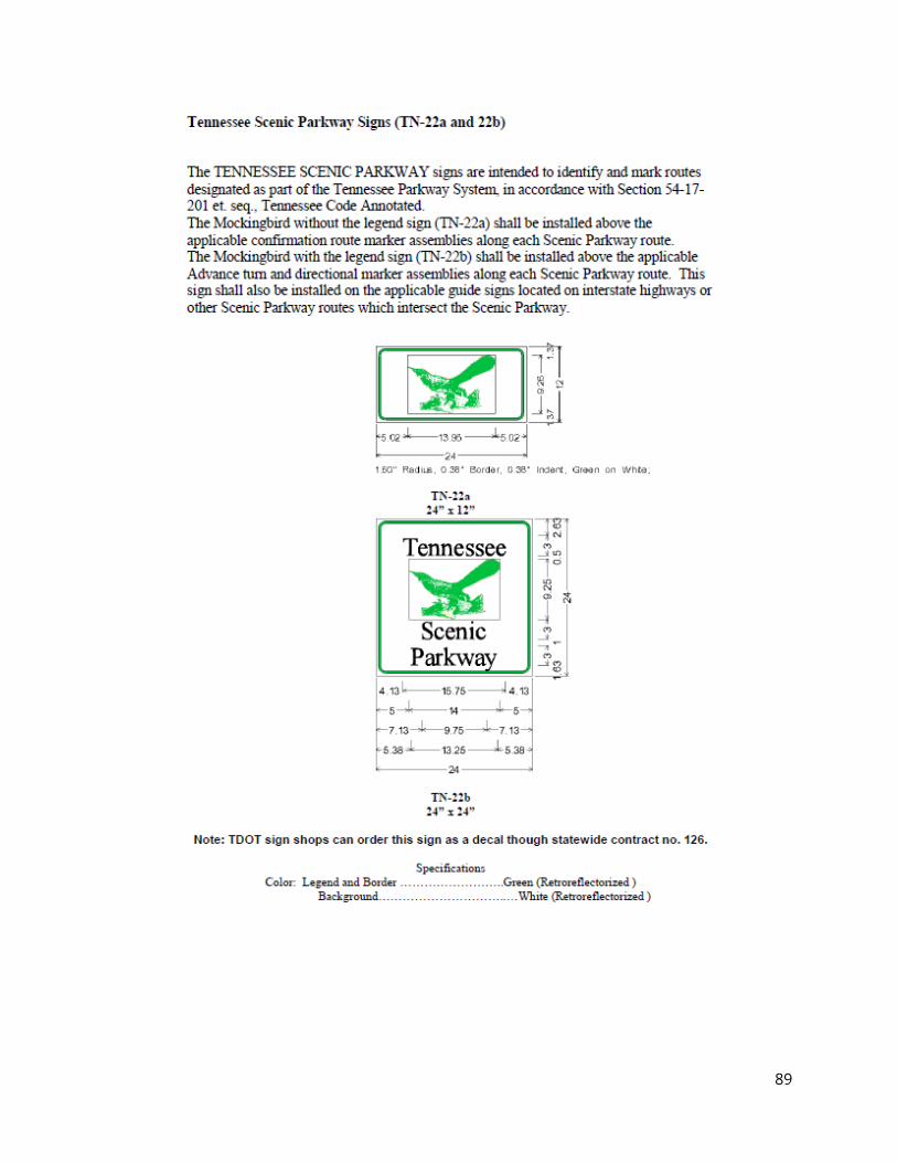
89
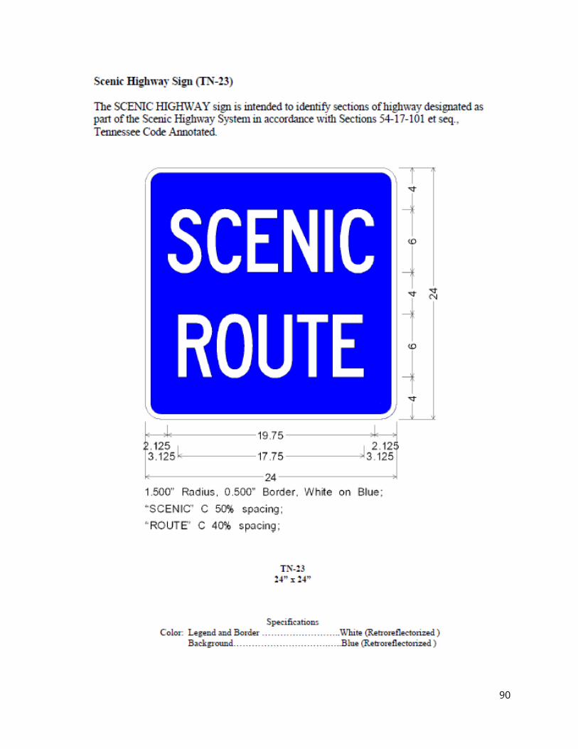
90
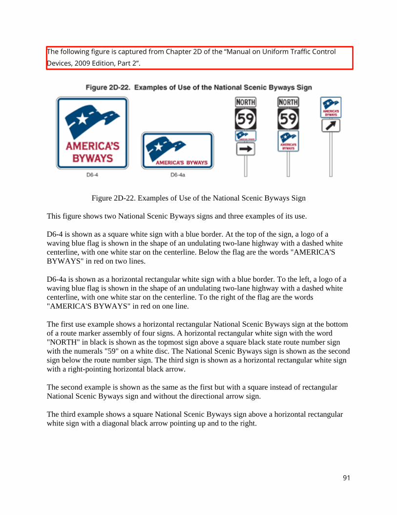
91
The following figure is captured from Chapter 2D of the “Manual on Uniform Traffic Control
Devices, 2009 Edition, Part 2”.
Figure 2D-22. Examples of Use of the National Scenic Byways Sign
This figure shows two National Scenic Byways signs and three examples of its use.
D6-4 is shown as a square white sign with a blue border. At the top of the sign, a logo of a waving blue flag is shown in the shape of an undulating two-lane highway with a dashed white centerline, with one white star on the centerline. Below the flag are the words "AMERICA'S BYWAYS" in red on two lines.
D6-4a is shown as a horizontal rectangular white sign with a blue border. To the left, a logo of a waving blue flag is shown in the shape of an undulating two-lane highway with a dashed white centerline, with one white star on the centerline. To the right of the flag are the words "AMERICA'S BYWAYS" in red on one line.
The first use example shows a horizontal rectangular National Scenic Byways sign at the bottom of a route marker assembly of four signs. A horizontal rectangular white sign with the word "NORTH" in black is shown as the topmost sign above a square black state route number sign with the numerals "59" on a white disc. The National Scenic Byways sign is shown as the second sign below the route number sign. The third sign is shown as a horizontal rectangular white sign with a right-pointing horizontal black arrow.
The second example is shown as the same as the first but with a square instead of rectangular National Scenic Byways sign and without the directional arrow sign.
The third example shows a square National Scenic Byways sign above a horizontal rectangular white sign with a diagonal black arrow pointing up and to the right.
92
TENNESSEE SCENIC HANDBOOK
TDOT’s Highway Beautification Office
Tennessee Department of Transportation 505 Deaderick Street, Suite 400
James K. Polk, Building Nashville, Tennessee 37243
(615) 741-2877 [email protected]
https://www.tn.gov/tdot.html and Search “Scenic Roadways”
America’s Byways Program
Program and Designation Info: https://www.fhwa.dot.gov/byways/ Tourism and Promotional Info: https://www.fhwa.dot.gov/byways/byways
National Scenic Byway Foundation
National Scenic Byway Foundation Post Office Box 212
Millersburg, Ohio 44654-0212 (339) 231-3468
[email protected] https://nsbfoundation.com/
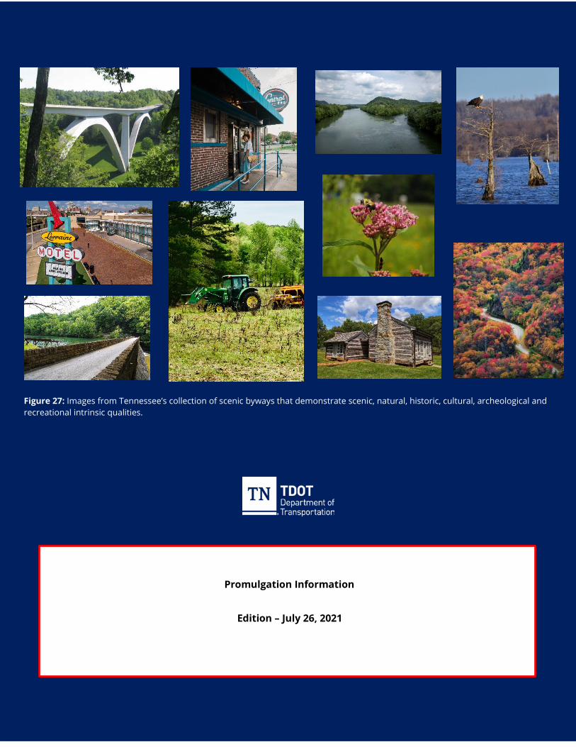
93
Promulgation Information
Edition – July 26, 2021
Figure 27: Images from Tennessee’s collection of scenic byways that demonstrate scenic, natural, historic, cultural, archeological and recreational intrinsic qualities.