Cumberland LEP Planning Proposal
57
1 PLANNING PROPOSAL – DRAFT CUMBERLAND LOCAL ENVIRONMENTAL PLAN – AUGUST 2020 PLANNING PROPOSAL DRAFT CUMBERLAND LOCAL ENVIRONMENTAL PLAN August 2020 (For finalisation)
Transcript of Cumberland LEP Planning Proposal

1 PLANNING PROPOSAL – DRAFT CUMBERLAND LOCAL ENVIRONMENTAL PLAN – AUGUST 2020
PLANNING PROPOSAL
DRAFT CUMBERLAND LOCAL ENVIRONMENTAL PLAN
August 2020
(For finalisation)

2 PLANNING PROPOSAL – DRAFT CUMBERLAND LOCAL ENVIRONMENTAL PLAN – AUGUST 2020
Contents EXECUTIVE SUMMARY .................................................................................................................... 3
PART 1 OBJECTIVES OR INTENDED OUTCOMES .................................................................... 6
PART 2 EXPLANATION OF PROVISIONS ................................................................................... 10
Part 1 Preliminary ........................................................................................................................... 10
Part 2 Permitted or Prohibited development .............................................................................. 12
Land Use Table .............................................................................................................................. 14
Open and closed zones ............................................................................................................. 14
Key land use considerations ..................................................................................................... 15
Part 3 Exempt and complying development .............................................................................. 18
Part 4 Principal development standards ..................................................................................... 19
Part 5 Miscellaneous provisions .................................................................................................. 22
Part 6 Local provisions .................................................................................................................. 24
Schedule 1 Additional permitted uses ......................................................................................... 29
Schedule 2 Exempt development ................................................................................................ 29
Schedule 3 Complying development ........................................................................................... 29
Schedule 4 Classification and reclassification of public land .................................................. 29
Schedule 5 Environmental Heritage ............................................................................................ 29
Schedule 6: Pond-based and tank-based aquaculture ............................................................ 30
Dictionary ......................................................................................................................................... 30
Maps ................................................................................................................................................. 30
PART 3 JUSTIFICATION .................................................................................................................. 31
A Need for the Planning Proposal ............................................................................................... 31
B Relationship to Strategic Planning Framework ...................................................................... 32
C Environmental, social and economic impact .......................................................................... 45
D State and Commonwealth interests ........................................................................................ 49
PART 4 MAPPING ............................................................................................................................. 50
PART 5 COMMUNITY CONSULTATION ...................................................................................... 51
PART 6 PROJECT TIMELINE ......................................................................................................... 57
3 PLANNING PROPOSAL – DRAFT CUMBERLAND LOCAL ENVIRONMENTAL PLAN – AUGUST 2020
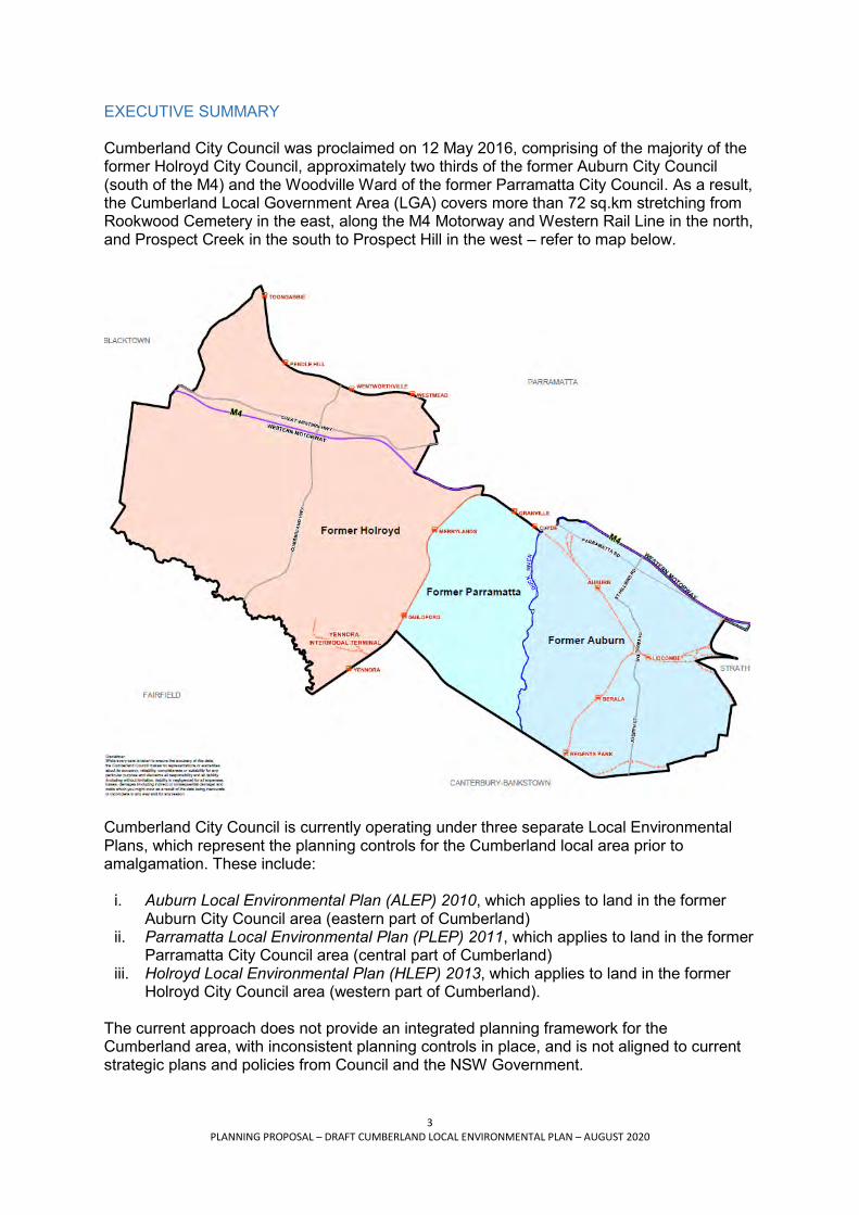
EXECUTIVE SUMMARY Cumberland City Council was proclaimed on 12 May 2016, comprising of the majority of the former Holroyd City Council, approximately two thirds of the former Auburn City Council (south of the M4) and the Woodville Ward of the former Parramatta City Council. As a result, the Cumberland Local Government Area (LGA) covers more than 72 sq.km stretching from Rookwood Cemetery in the east, along the M4 Motorway and Western Rail Line in the north, and Prospect Creek in the south to Prospect Hill in the west – refer to map below.
Cumberland City Council is currently operating under three separate Local Environmental Plans, which represent the planning controls for the Cumberland local area prior to amalgamation. These include:
i. Auburn Local Environmental Plan (ALEP) 2010, which applies to land in the former Auburn City Council area (eastern part of Cumberland)
ii. Parramatta Local Environmental Plan (PLEP) 2011, which applies to land in the former Parramatta City Council area (central part of Cumberland)
iii. Holroyd Local Environmental Plan (HLEP) 2013, which applies to land in the former Holroyd City Council area (western part of Cumberland).
The current approach does not provide an integrated planning framework for the Cumberland area, with inconsistent planning controls in place, and is not aligned to current strategic plans and policies from Council and the NSW Government.

4 PLANNING PROPOSAL – DRAFT CUMBERLAND LOCAL ENVIRONMENTAL PLAN – AUGUST 2020
This Planning Proposal seeks to harmonise the three existing LEPs applying to Cumberland City with the aim of creating a consolidated and clear planning framework under a single Cumberland LEP. The Planning Proposal has been prepared by Cumberland City Council and describes the proposal to consolidate the planning controls of the former Auburn, Parramatta and Holroyd Councils as they apply to land in Cumberland City. It has been prepared in accordance with section 3.33 of the Environmental Planning and Assessment Act 1979 and the relevant the Department of Planning, Industry and Environment’s guidelines, including:
A Guide to Preparing Local Environmental Plans A Guide to Preparing Planning Proposals LEP Roadmap: Guidelines for updating LEPs to give effect to the District Plans in the
Greater Sydney Region. The Planning Proposal applies to all land in Cumberland City. Planning context Changes to the Environmental Planning and Assessment Act 1979 in March 2018 require all metropolitan councils to review and amend their existing LEPs to make sure they align with the relevant District Plan and Greater Sydney Region Plan. Cumberland has been identified as a priority council by the Greater Sydney Commission meaning it must complete the LEP review within two years (by 30 June 2020). Council is taking the opportunity presented by the LEP review process to harmonise the provisions of the three legacy LEPs operating across Cumberland City into a single set of planning controls under a consolidated Cumberland LEP. Gateway Determination, Local Planning Panel advice and Council endorsement The draft Cumberland LEP Planning Proposal was reported to the Cumberland Local Planning Panel in February 2020 with a recommendation to process to the next stage for a Gateway Determination. The Panel supported the Council officer recommendation. A copy of the Panel report and advice is provided at Attachment 1. Council considered the matter at its Ordinary Meeting of 4 March 2020 [C03/20-388], prior to undertaking public exhibition. At its meeting in September 2019 [C09/19-219] Council resolved to endorse the Planning Proposal for the new Cumberland LEP and proceed to Gateway. A copy of the Council report and resolution is provided at Attachment 3. A Gateway Determination was received in March 2020, and the Planning Proposal for the draft Cumberland LEP was publicly exhibited in April and May 2020.
A post exhibition report on proposed changes to the draft LEP Planning Proposal, in response to further review and submissions, was considered by the Cumberland Local Planning Panel in June 2020. The Panel generally supported the Council officer recommendations for administrative items and minor zoning changes to be included in the LEP prior to finalisation. The Panel also considered a report on site specific requests for rezoning and/or planning control changes and supported the proposed stream classification approach and scope of Council’s strategic planning work program.
The outcomes and recommendations of the post exhibition review, including consideration of submissions, are included in this Planning Proposal.
Council resolutions Council considered and endorsed much of the detail of the new Cumberland LEP in late 2019 and early 2020 through various reports that dealt with particular issues and planning
5 PLANNING PROPOSAL – DRAFT CUMBERLAND LOCAL ENVIRONMENTAL PLAN – AUGUST 2020
controls. The Planning Proposal has been prepared and exhibited in accordance with Council’s resolutions, in particular those of 18 September 2019 and 4 March 2020. The Planning Proposal has also been updated in accordance with Council’s post exhibition report and resolution on 15 July 2020, to address a range of matters including the Council officer response to the Cumberland Local Planning Panel’s advice, administrative items associated with the LEP, and submissions received from government agencies and landowners. Supporting documentation The Planning Proposal is supported by the following documentation:
Attachment 1 – C07/20-501 Cumberland Local Environmental Plan - Post Exhibition Report on new Planning Controls for Cumberland City, 15 July 2020 Attachment 2 – C09/19-218 Early Consultation for the New Cumberland Local Environmental Plan, 18 September 2019 Attachment 3 – C09/19-219 Planning Proposal for the New Cumberland Local Environmental Plan, 18 September 2019 Attachment 4 – C03/20-288 Update on Planning Proposal for the New Cumberland Local Environmental Plan, 4 March 2020 Attachment 5 – Background Report: Cumberland Local Environmental Plan Harmonisation Attachment 6 – Auburn Town Centre Planning Controls Strategy Attachment 7 – Lidcombe Town Centre Planning Controls Strategy Attachment 8 – Auburn and Lidcombe Town Centres: Urban Form Modelling Attachment 9 – Auburn and Lidcombe Town Centres: Indicative Development Potential Attachment 10 – Proposed zoning changes for the Merrylands East Centre Attachment 11 – Proposed planning approach for the Woodville Road Corridor Attachment 12 – Proposed planning approach for the Parramatta Road Corridor Attachment 13 – Proposed planning controls for Schedule 5 of the new Cumberland LEP Attachment 14 – Summary table of proposed miscellaneous (site specific) zoning and/or planning control changes Attachment 15 – Planning Proposal – Minimum lot area for Low and Medium Density dual occupancy housing

6 PLANNING PROPOSAL – DRAFT CUMBERLAND LOCAL ENVIRONMENTAL PLAN – AUGUST 2020
PART 1 OBJECTIVES OR INTENDED OUTCOMES This Planning Proposal seeks to facilitate a new Local Environmental Plan (LEP) for Cumberland which provides the key planning controls for the area, including land use activities, zoning, building heights and density. A single Cumberland LEP will simplify the planning process by reducing the number of planning instruments applicable to land in the Cumberland LGA, removing duplication of planning controls and aligning, where possible, the land uses and controls within the current instruments. The new LEP is not intended to be a comprehensive review of all planning controls, but a consolidation of the existing LEPs applicable across the Cumberland local area. The approach to the harmonisation (merge) of Cumberland’s three legacy LEPs into a single consolidated Plan is summarised ‘in principle’ below.
Principle 1: As far as practicable, apply the same planning approach across the LGA (focus on creating a consistent set of general land use policies and development controls for Cumberland). Principle 2: Adopt Standard Instrument LEP clauses as required, with local content included where possible. Principle 3: Use ‘best-fit’ to retain/continue current planning outcomes in instances where the existing Cumberland LEPs do not align. Principle 4: Introduce new policy/planning approach only if appropriate.
In addition to harmonising the existing LEPs, the planning proposal seeks to implement a targeted range of other strategic planning work that has been substantially progressed as separate and individual projects, including:
i. Revised planning controls for the Auburn and Lidcombe Town Centres (implementation of the Auburn and Lidcombe Town Centres Planning Controls Strategies, adopted by Council on 21 August and 4 September 2019 respectively, and considered by the CLPP on 20 June 2019).
ii. Minimum lot sizes for dual occupancy development, by providing consistent lot sizes
across the Cumberland area (generally in accordance with the planning approach adopted by Council on 19 June 2019, and considered by the CLPP on 15 May 2019)
iii. Targeted changes to planning controls along the Parramatta and Woodville Road
Corridors (as previously considered and adopted by Council on 3 July 2019).
iv. Stage 1 of the Cumberland Heritage Study, including the proposed de-listing of 9 properties that have been assessed as no longer meeting the NSW heritage criteria for assessing heritage significance (delisting of properties adopted by Council on 4 September 2019).
v. Miscellaneous minor zoning and/or planning control changes. In particular, the
planning proposal seeks to clarify the land use permissibility of government owned land, and address selected site specific anomalies on privately owned sites, through appropriate minor zoning and/or planning control changes in various locations across Cumberland.

7 PLANNING PROPOSAL – DRAFT CUMBERLAND LOCAL ENVIRONMENTAL PLAN – AUGUST 2020
Details and justification for these changes are outlined below and in the respective attachments to this Planning Proposal. The draft Cumberland LEP may also be amended prior to being made to incorporate any proposed amendments to the Auburn, Parramatta and/or Holroyd LEP, if the amendment to the existing instrument is made prior to the making of the Cumberland LEP. Note: Any draft proposed LEP clauses will be subject to legal drafting and may change under this process. Auburn Town Centre Planning Controls Strategy The Planning Proposal seeks to implement the recommendations of the Auburn Town Centre Planning Controls Strategy to support better built form design outcomes that will contribute to the quality of amenity and public domain in the area. The primary focus of the strategy and proposed changes to planning controls is to better align the zoning, height and density controls (floor space ratios) to enable a broader range of building design options to be realised. The proposed controls provide better opportunities for innovation in the built form in the town centre, and contribute to the quality of amenity and public domain within the Cumberland area. A copy of Council report and resolution C08/19-176 in support of the Auburn Town Centre Planning Controls Strategy is provided at Attachment 6. Indicative urban form modelling in support of the proposed changes is also provided at Attachment 8. An indication of development potential within the town centre under both the existing and proposed planning controls is provided at Attachment 9. Specific details of the proposed planning controls changes are shown on the draft LEP maps. Lidcombe Town Centre Planning Controls Strategy The Planning Proposal seeks to implement recommendations of the Lidcombe Town Centre Planning Controls Strategy. The strategy supports better built form design outcomes that will contribute to the quality of amenity and public domain in the area. The primary focus of the strategy and proposed changes to planning controls is to better align the zoning, height and density controls (floor space ratios) to provide better opportunities for built form within the projected dwelling capacity without increasing density. The proposed controls provide better opportunities for innovation in the built form in the town centre, and contribute to the quality of amenity and public domain within the Cumberland area. A copy of Council report and resolution C09/19-189 in support of the Lidcombe Town Centre Planning Controls Strategy is provided at Attachment 7. Indicative urban form modelling in support of the proposed changes is also provided at Attachment 8. An indication of development potential within the town centre under both the existing and proposal planning controls is provided at Attachment 9. Specific details of the proposed planning controls changes are shown on the draft LEP maps. Merrylands East Neighbourhood Centre (John Cootes site) The Planning Proposal seeks to rezone the Merrylands East Centre (John Cootes Site) at 264 Woodville Road, Merrylands, from B4 Mixed Use to part B2 Local Centre and part RE1 Public Recreation to reflect Council’s strategic approach to local centres and objectives of the Central City District Plan. A copy of Council report and resolution C02/29-15 outlining the proposed zoning changes is provided at Attachment 10. Further minor post-exhibition amendments are provided in Attachment 1.

8 PLANNING PROPOSAL – DRAFT CUMBERLAND LOCAL ENVIRONMENTAL PLAN – AUGUST 2020
Targeted changes to planning controls along the Parramatta Road Corridor The Planning Proposal seeks to implement part of the NSW Government’s Parramatta Road Urban Transformation Strategy (PRCUTS). In particular, the planning proposal seeks to:
i. introduce B1 Neighbourhood Centre zones on corners at Parramatta Road/Silverwater Road and Parramatta Road/Hampstead Road (and adjust the alignment of the orange edging denoting the FSR incentive for the B6 zone accordingly),
ii. introduce a B6 Enterprise Corridor zone along St Hilliers Road, and iii. revise FSR and height of building controls (as mapped) for the introduced B1 and B6
zones in accordance with the Strategy.
The inclusion of these changes in the Planning Proposal responds to a Council resolution dating back to April 2017, where Council resolved to implement the PRCUTS and commission a traffic and transport study to determine the likely impact of planned increases in population on Parramatta Road and the broader road network. The traffic and transport study commenced in May 2018, in conjunction with Transport for NSW and other affected councils along the corridor. This work is continuing. Council subsequently resolved in July 2019 to pursue a staged approach to progress land use planning for the Parramatta Road corridor, aligned with growth forecasts, market demand and infrastructure requirements. This approach was identified to enable Council to progress targeted initiatives in the short term while continuing our long term strategic planning along the corridor with the NSW Government. Part of the staged approach is the inclusion of the targeted changes for sites in the Auburn Precinct in the Planning Proposal for the draft Cumberland LEP. Inclusion of these proposed changes is subject to NSW government approval. Planning controls for existing medium and high density residential development along the Woodville Road Corridor The Planning Proposal seeks to rezone various sites along the Woodville Road Corridor from R2 Low Density Residential to either R3 Medium Density or R4 High Density Residential to reflect existing approved development, with corresponding changes to building height and floor space ratio controls consistent with similar developments in the area. A copy of Council report and resolution C07/19-131 outlining the proposed planning approach for the Woodville Road Corridor is provided at Attachment 11. A number of site specific submissions seeking similar planning control amendments along the Woodville Road Corridor were received during the public exhibition period. In accordance with advice from the Cumberland Local Planning Panel, Council resolved to examine these requests holistically as part of its future work program of planning reviews for strategic centres and corridors. Further details on this approach are provided in the Council report and resolution C07/20-501 at Attachment 1. Cumberland Heritage Study Stage 1 The Planning Proposal seeks to implement the recommendations of Stage 1 of the Cumberland Heritage Study, involving a review of all existing heritage items (including conservation areas) listed in the Auburn, Holroyd and Parramatta LEPs and located in the Cumberland LGA. This includes the proposed de-listing of 9 properties that no longer meet the NSW heritage criteria for assessing heritage significance (ie. the Planning Proposal does not seek to carry-over these properties to the new Cumberland LEP). The 9 properties that will not be carried over as heritage items for the new Cumberland LEP are:
i. 36 and 38 Jamieson Street, Granville

9 PLANNING PROPOSAL – DRAFT CUMBERLAND LOCAL ENVIRONMENTAL PLAN – AUGUST 2020
ii. 10 William Street, Granville iii. 9-11 Woodville Road, Granville iv. 4 Myall Street, Merrylands v. Guildford Railway Station, Railway Terrace, Guildford vi. 1-7 Neil Street, Merrylands (Millmaster Feeds Site) vii. 34 Garfield Street, Wentworthville viii. 15 Abbott Street, Merrylands ix. 70 Jersey Road, South Wentworthville
A copy of the Council report and resolution C09/19-193 outlining the proposed planning controls for Schedule 5 of the new Cumberland LEP is provided at Attachment 13. Miscellaneous minor zoning and/or planning control changes The Planning Proposal seeks to clarify the land use permissibility of government owned land, and address selected site specific anomalies on privately owned sites, through appropriate and minor zoning changes and/or planning controls changes in various locations across Cumberland. This includes changes on land owned by Sydney Water and Sydney Trains, as well as privately owned land. A small number of additional minor zonings are proposed following further review and consideration of issues raised in submissions. A summary table of proposed site specific zoning and/or planning control changes is provided at Attachments 1 and 14. Specific details of the proposed planning controls changes are shown on the draft LEP maps.

10 PLANNING PROPOSAL – DRAFT CUMBERLAND LOCAL ENVIRONMENTAL PLAN – AUGUST 2020
PART 2 EXPLANATION OF PROVISIONS The objectives and intended outcome of this Planning Proposal will be facilitated by the preparation of a single LEP in accordance with the Standard Instrument (LEP) Order 2006, which harmonises and consolidates the planning controls within the following documents currently in force across the Cumberland LGA:
i. Auburn Local Environmental Plan 2010 ii. Parramatta Local Environmental Plan 2011 iii. Holroyd Local Environmental Plan 2013
Each of the existing LEPs were prepared in the Standard Instrument LEP format. However, they include objectives and clauses in addition to those mandated in the Standard Instrument LEP and therefore differ in various ways. For the most part, the content and controls generally align in so far as application and intent. Where there is a fundamental difference across the three LEPs, particularly in the case of the land use tables and principal development standards, for the purpose of harmonisation and consolidation the Standard Instrument LEP approach will prevail and/or the provision has been adjusted so that a ‘best fit’ approach applies. The proposed contents of the new Cumberland LEP as a result of this Planning Proposal are as follows: Part 1 Preliminary Part 1 of the consolidated Cumberland LEP covers a range of preliminary matters including the overall aims of the Plan, where the Plan applies, relationships with other instruments as well as transitional arrangements. Most items in this part are compulsory clauses under the Standard Instrument LEP and must be included in the new Cumberland LEP. Where appropriate, the Planning Proposal seeks to include specific content relevant to the Cumberland local area. An explanation of proposed clauses to be included in Part 1 of the new Cumberland LEP is provided below. Name of Plan The Plan will be called the Cumberland Local Environmental Plan 2020. Commencement The Plan will commence on the day on which it is published on the NSW legislation website. Aims of Plan The aims of the Plan, being a consolidation of the aims of the existing three LEPs and updated to reflect the future desired direction for Cumberland, are:
a) Establish a planning framework for sustainable land use and development in Cumberland
b) Provide for a range of land uses and developments in appropriate locations across the Cumberland area
c) Facilitate economic growth and employment opportunities in Cumberland d) Protect and enhance the natural, built and cultural heritage of the Cumberland area e) Support the provision of community facilities and services in Cumberland to meet the
needs of residents, workers and visitors f) To encourage and promote development that is environmentally sustainable

11 PLANNING PROPOSAL – DRAFT CUMBERLAND LOCAL ENVIRONMENTAL PLAN – AUGUST 2020
Land to which Plan applies The land to which the Plan applies will be shown on the Land Application Map and includes the whole of the Cumberland LGA. Definitions This clause will be as per the Standard Instrument LEP. The clause references the Dictionary to be included at the end of the Plan to define certain words and expressions. Notes This clause will be as per the Standard Instrument LEP. This is an advisory clause only. Consent authority Council will be the consent authority for the purposes of the Plan (subject to the Act). Maps This clause will be as per the Standard Instrument LEP. Repeal of planning instruments applying to land This clause will be as per the Standard Instrument LEP. Application of SEPPs This clause will be as per the Standard Instrument LEP. Savings Provision The Planning Proposal seeks to include a savings provision within the new Cumberland LEP to ensure that any development applications which were submitted prior to the [gazetted] Plan will be decided in accordance with the current LEPs in force.

12 PLANNING PROPOSAL – DRAFT CUMBERLAND LOCAL ENVIRONMENTAL PLAN – AUGUST 2020
Part 2 Permitted or Prohibited development Part 2 of the consolidated Cumberland LEP provides information on permitted or prohibited development, including land use zones and the application area for zones. Reference is also made to the Land Use Table, which outlines the zone objectives, permitted land uses and prohibited land uses. Most items in this part are compulsory clauses under the Standard Instrument LEP and must be included in the new Cumberland LEP. Where appropriate, the Planning Proposal seeks to include specific content relevant to the Cumberland local area. An explanation of proposed clauses to be included in Part 2 of the new Cumberland LEP is provided below. Land use zones This clause will include a list of all zones used across the existing three LEPs, as follows:
Residential Zones R2 Low Density Residential R3 Medium Density Residential R4 High Density Residential Business Zones B1 Neighbourhood Centre B2 Local Centre B4 Mixed Use B5 Business Development B6 Enterprise Corridor Industrial Zones IN1 General Industrial IN2 Light Industrial Special Purpose Zones SP1 Special Activities SP2 Infrastructure Recreation Zones RE1 Public Recreation RE2 Private Recreation Environment Protection Zones E2 Environmental Conservation Waterway Zones W1 Natural Waterways
The Planning Proposal does not seek to introduce any new zones, or remove any existing zones as applicable to the Cumberland LGA. Zoning of land to which Plan applies This clause will be as per the Standard Instrument LEP. The clause states that land is within the zones shown on the Land Zoning Map. The Planning Proposal does not seek to change the zoning of most of the land that is already zoned under the Auburn, Parramatta or Holroyd LEPs within the Cumberland LGA. The Planning Proposal seeks to continue the existing application of zones for the new

13 PLANNING PROPOSAL – DRAFT CUMBERLAND LOCAL ENVIRONMENTAL PLAN – AUGUST 2020
Cumberland LEP Land Zoning Maps, as far as possible. In instances where zoning changes are proposed to be made, these are identified in this Planning Proposal. Zone objectives and Land Use Table This clause will be as per the Standard Instrument LEP. The clause references the Land Use Table and requires the consent authority to have regard to the objectives for development in a zone when determining a development application. Unzoned Land This clause will be as per the Standard Instrument LEP. The clause states that consent is required for development on unzoned land. Additional permitted uses for particular land This clause will be as per the Standard Instrument LEP. The clause allows the consent authority to grant consent for particular development not otherwise permitted in a zone. The clause refers to Schedule 1 which will include all additional permitted uses that currently apply to land in Cumberland under the existing Auburn, Parramatta and Holroyd LEPs. Subdivision – consent requirements This clause will be as per the Standard Instrument LEP. The clause requires development consent for land to be subdivided, and specifically excludes subdivision of land comprising secondary dwellings unless each resulting lot achieves the applicable minimum lot size. Demolition requires development consent This clause will be as per the Standard Instrument LEP. The clause requires development consent for demolition of a building, unless identified as exempt development under Schedule 2 or the Exempt and Complying Development Codes SEPP 2008. Temporary use of land This clause allows development consent to be granted for a temporary use provided it does not compromise future development of the land, or cause any detrimental economic, social, amenity or environmental effects. Both the Auburn LEP 2010 and Parramatta LEP 2011 stipulate 28 days as the maximum period of development consent for a temporary use in any zone. The Holroyd LEP allows up to 52 days. The Planning Proposal seeks to include 52 days as the maximum period of development consent for a temporary use in any zone in the new Cumberland LEP. This approach is consistent with the suggested approach in the Standard Instrument LEP and will further reduce the regulatory burden in the former Auburn and Parramatta LEP areas to facilitate opportunities for creative and artistic expression and participation, consistent with the Liveability Priorities (Action 14) of the Central City District Plan.

14 PLANNING PROPOSAL – DRAFT CUMBERLAND LOCAL ENVIRONMENTAL PLAN – AUGUST 2020
Land Use Table The Planning Proposal seeks to merge the Land Use Table provisions in the existing Auburn, Parramatta Holroyd LEPs to form a combined and consistent suite of land use zones for the new Cumberland LEP. In preparing the Land Use Table, a general rule of permissibility retention has been used. This means that the permissible land uses in most zones proposed for the new Cumberland LEP are a combination of the permissible land uses of the existing LEPs that apply in the Cumberland area. For example, if a use is permissible within a zone under the current Auburn, Holroyd or Parramatta LEPs, it is generally proposed to be permitted within that zone under the new Cumberland LEP. However, some changes to the permissible or prohibited uses within each zone are necessary to establish consistent controls for each land use zone. Open and closed zones In preparing the Land Use Table, Council has considered whether a zone should be open or closed. An open zone is one where a broad variety of land uses can be considered allowing greater flexibility and minimising the need to undertake ‘spot rezonings’. A closed zone is one where the diversity of land uses is more restrictive, meaning development types are chosen primarily from only one or two key ‘group’ terms. Where the Planning Proposal seeks to adopt an ‘open’ approach, the Land Use Table for that zone will:
specifically list any mandated or other uses that may be undertaken without consent under Item 2 ‘Permitted without consent’
specifically list any mandated or other land uses as prohibited under Item 4 ‘Prohibited’
specifically list any mandated or other uses in Item 3 ‘Permitted with consent’ to achieve the zone objectives. In addition, the zone table will include the words ‘Any development not specified in Item 2 or 4.’
Where the Planning Proposal seeks to adopt a ‘closed’ approach, the Land Use Table for that zone will:
specifically list any mandated or other uses that may be undertaken without consent under Item 2 ‘Permitted without consent’
specifically list any mandated or other land uses as permitted with consent under Item 3 ‘Permitted with consent’ to achieve the zone objectives
specifically list any mandated land uses as prohibited in item 4 and add ‘Any development not specified in Item 2 or 3’.
The Planning Proposal seeks to include the following approach to the Land Use Table for the new Cumberland LEP, based on the recommended approach in the Department of Planning, Industry and Environment’s LEP Practice Note PN 11-002 and the principle of maintaining consistency and permissibility retention across the three existing LEPs as far as possible: Zone Approach to Land Use Table Residential Zones R2 Low Density Residential Closed R3 Medium Density Residential Closed R4 High Density Residential Open Business Zones

15 PLANNING PROPOSAL – DRAFT CUMBERLAND LOCAL ENVIRONMENTAL PLAN – AUGUST 2020
B1 Neighbourhood Centre Closed B2 Local Centre Open B4 Mixed Use Open B5 Business Development Open B6 Enterprise Corridor Open Industrial Zones IN1 General Industrial Open IN2 Light Industrial Open Special Purpose Zones SP1 Special Activities Closed SP2 Infrastructure Closed Recreation Zones RE1 Public Recreation Closed RE2 Private Recreation Closed Environment Protection Zones E2 Environmental Conservation Closed Waterways Zones W1 Natural Waterways Closed
Key land use considerations In harmonising and consolidating the existing Auburn, Parramatta and Holroyd LEPs, several key land use issues were identified. The Planning Proposal seeks to address them as follows: Home businesses Various sites across the Cumberland LGA are identified for future open space to serve the needs of our growing population. The Planning Proposal seeks to include ‘home businesses’ as a permissible use in the RE1 and RE2 zones to provide continued opportunities for existing dwellings on these sites, until such time as the land is required for its intended recreation use. Council resolved to include this approach following the public exhibition period to provide certainty for landowners. The approach is consistent with State Environmental Planning Policy (Exempt and Complying Development Codes) 2008. Office premises Office premises are currently permissible in the B6 Enterprise corridor zone under the Auburn LEP and Parramatta LEP. The exclusion of office premises from the list of permissible uses in the B6 Enterprise Corridor Zone was an unintended consequence of the harmonisation process identified during the exhibition period. Council subsequently resolved to carry over this permissibility and include ‘office premises’ as a permitted use in the B6 zone for the new Cumberland LEP. Places of Public Worship The ABS lists over 40 individual religions within the Cumberland community. Activities associated with the development of public worship and multi-use facilities in Cumberland can result in changes to traffic flow, parking availability and impact on the prevailing amenity of an area. Council has considered the many planning issues relating to places of public worship in Cumberland, in order to better manage this type of development and address community expectations. The proposed planning approach takes into consideration the diverse and differing cultural and religious themes that surround all places of public worship in Cumberland, and seeks to balance support for these uses within the community, while at the same time protect the amenity of low density residential areas and town centres.

16 PLANNING PROPOSAL – DRAFT CUMBERLAND LOCAL ENVIRONMENTAL PLAN – AUGUST 2020
The permissibility of places of public worship currently varies across the existing three LEPs. They are permissible uses in all the residential, business and industrial zones under the Auburn and Holroyd LEPs. Under the Auburn LEP, places of public worship are also permissible within the SP1 Special Activities, SP2 Infrastructure, RE1 Public Recreation and RE2 Private Recreation zones. The Parramatta LEP does not permit places of public worship within the R2 Low Density Residential zone. Where existing places of public worship are located within a low-density residential area in the Parramatta area, they are zoned SP1. The Planning Proposal seeks to adopt the Standard Instrument LEP approach to the permissibility of places of public worship for the new Cumberland LEP by permitting them with consent only in the R3, R4, IN1 and IN2 zones (and specifically prohibiting them in all other zones). This will protect the amenity of low density residential areas in all of Cumberland by prohibiting the development of places of public worship in the R2 zone while continuing to permit them only where they are compatible with both the existing and future desired character of the area. Existing sites identified as SP1 Place of Public Worship in the Parramatta LEP, within low density residential areas, will assume the adjacent zoning at that location. Existing use rights will permit the continuation of current approved places of public worship in the R2 zone under the new Cumberland LEP. This approach is appropriate to allow for a transition of land to the new preferred planning outcomes. In addition, the Planning Proposal seeks to include a special local provision in the new Cumberland LEP that sets a minimum lot size of 2,000 sq.m for places of public worship in the R3 and R4 zones, along with urban design considerations for development assessment. This will be reinforced by the inclusion of the following additional objective in the land use table for the R3 and R4 zones:
to ensure that non-residential land uses are located in a context and setting that minimises impacts on the amenity of the surrounding residential environment.
The LEP control will be supported by detailed Development Control Plan provisions relating to locational requirements, site coverage, setbacks, built form, car parking and traffic management, landscaping, amenity, operational management and the like, to be prepared and considered separately to this Planning Proposal. Residential Flat Buildings Residential flat buildings (RFBs) are currently permitted within the R4 zone in all three LEPs, whereas only Auburn LEP permits RFBs in the B1 and B2 zones. Both Parramatta and Auburn LEPs currently permit RFBs in the B4 Zone. Only the Holroyd LEP permits RFBs within the B6 zone. The objectives of the B6 zone are to promote business and provide a range of employment uses. In addition, one of the key messages of Cumberland 2030: Our Local Strategic Planning Statement is to ‘promote access to local jobs’. A continued increase in residential development within business zones has the potential to create a negative impact. In addition, RFBs often do not include active ground floor street frontage which especially within the B6 zone can have a negative impact on the vibrancy, amenity and economic offering of the zone. The Planning Proposal therefore seeks to prohibit RFBs within the B6 zones in the new Cumberland LEP to support these outcomes. Following public exhibition and further detailed review of planning controls, Council resolved that residential flat buildings should continue to be permitted with consent in the B2 and B4

17 PLANNING PROPOSAL – DRAFT CUMBERLAND LOCAL ENVIRONMENTAL PLAN – AUGUST 2020
zones to provide a range of development opportunities that respond to local market conditions and ensure our town centres are vibrant and inclusive places for the community. Shop top housing Residential accommodation in the form of shop top housing is currently permitted with consent within the B6 zone in the Holroyd LEP (it is prohibited in the B6 zone under the Auburn and Parramatta LEPs). Similar to the above, in order to support business development in the B6 zones, the Planning Proposal seeks to prohibit residential accommodation within the B6 zones in the new Cumberland LEP. Notwithstanding, the Planning Proposal also seeks to include a new local provision to continue to allow shop top housing on land zoned B6 in the Mays Hill and Finlayson Transitway Precincts in accordance with the existing strategic intent for these precincts described in the Development Control Plan. This approach was included following public exhibition and further detailed review of controls to resolve an unintended consequence of the harmonisation process. Seniors housing Seniors Housing can either be specifically permissible within land use zones or, in certain circumstances approved under State Environmental Planning Policy (Housing for Seniors or People with a Disability) 2004. The Policy encourages the provision of housing for seniors and people with a disability in areas where this form of housing might otherwise not be permissible. It specifically applies to land zoned for urban purposes where dwellings houses, residential flat buildings, hospitals and special uses are permissible. The Planning Proposal seeks to include ‘seniors housing’ as a specifically permitted use in the B4 zone to ensure that this form of housing can continue to be located on sites that are accessible to shops, services, health care, social and recreation facilities. Sex services premises Sex services premises are currently permissible in the IN1 zone under the Auburn LEP, and in both the IN1 and IN2 zones under the Parramatta LEP. Sex services premises are prohibited in all zones under the Holroyd LEP, with the exception of a handful of sites identified in Schedule 1 Additional permitted uses. The Planning Proposal seeks to permit sex services premises with consent in the IN1 zone only, and specifically exclude them elsewhere in the new Cumberland LEP. The Planning Proposal will also continue to allow sex services premises on sites currently listed in Schedule 1 of the Holroyd LEP.

18 PLANNING PROPOSAL – DRAFT CUMBERLAND LOCAL ENVIRONMENTAL PLAN – AUGUST 2020
Part 3 Exempt and complying development Part 3 and associated Schedules 2 and 3 of the new Cumberland LEP specify development types which may be undertaken as either Exempt (which does not require an approval from Council) or Complying Development (certain development that can be undertaken subject to a limited approval) and subject to State Environmental Planning Policy (Exempt and Complying Development) 2008. All items in this Part and Schedules are compulsory and must be included in the LEP. An explanation of proposed clauses to be included in Part 3 of the new Cumberland LEP is provided below. Exempt development The Planning Proposal does not seek to introduce any new controls for exempt development. It relies upon the provisions of Schedule 2 and State Environmental Planning Policy (Exempt and Complying Development Codes) 2008. The range of exempt land uses to be included in the new Cumberland LEP is consistent with the existing three LEPs. Complying development The Planning Proposal does not seek to introduce any new controls for complying development. It relies upon the provisions of Schedule 3 and State Environmental Planning Policy (Exempt and Complying Development Codes) 2008. The range of complying land uses to be included in the new Cumberland LEP is consistent with the existing three LEPs. Environmentally sensitive areas excluded This clause will be as per the Standard Instrument LEP. The clause defines an ‘environmentally sensitive area’ where exempt or complying development must not be carried out. One minor post-exhibition change is proposed: the addition of land identified as ‘remnant native vegetation’ to the Biodiversity map to ensure adequate protection of this land and vegetation.

19 PLANNING PROPOSAL – DRAFT CUMBERLAND LOCAL ENVIRONMENTAL PLAN – AUGUST 2020
Part 4 Principal development standards Part 4 of the new Cumberland LEP provides key development standards relating to the use of land. Many of the provisions are optional under the Standard Instrument LEP, but if adopted contain standard content that can be tailored to local conditions. The Planning Proposal seeks to include a range of principal development standards in the new Cumberland LEP based on the following principles:
i. Apply a consistent planning approach across the Cumberland area as far as practicable
ii. Adopt Standard Instrument LEP clauses as required, with local content included where possible
iii. Use ‘best-fit’ to retain/continue current planning outcomes in instances where the existing LEPs operating in Cumberland do not align
iv. Introduce new policy or planning approach only if appropriate. The Planning Proposal seeks to continue the relevant principal development standards included in the existing Auburn, Parramatta and Holroyd LEPs to the new Cumberland LEP largely unchanged. An explanation of proposed clauses to be included in Part 4 of the new Cumberland LEP is provided below. Minimum subdivision lot size This clause allows Council to identify subdivision lot sizes for the Cumberland LGA on the Lot Size Map for the new LEP. The clause applies to a subdivision of any land shown on the Lot Size Map that requires development consent. Currently the three LEPs contain different objectives for this clause. The Planning Proposal seeks to include a consolidated and consistent set of clause objectives in the new Cumberland LEP, as follows:
a) to ensure that lot sizes can accommodate development consistent with relevant development controls
b) to ensure that subdivision of land is able to support the objectives of the relevant land use zone
c) to prevent fragmentation of land that would preclude the achievement of the land uses or development desired in a given locality
d) to ensure that new subdivisions reflect characteristic lot sizes and patterns of the area.
In accordance with Council’s post exhibition resolution, the Planning Proposal seeks to allow Torrens Title subdivision for attached and detached dual occupancies in the R2 and R3 zones. In addition, the Planning Proposal seeks to continue certain development and site specific controls from the Auburn and Parramatta LEPs relating to dwelling houses, battle-axe lots, subdivision of dual-occupancies and the former Lidcombe Hospital site. Minimum subdivision lot size for community title schemes This clause seeks to ensure that land is not fragmented by subdivisions that would create additional dwelling entitlements. The clause enables the consent authority to control the size of lots under community title schemes through the Minimum Lot Size Map. Currently only the Holroyd LEP has adopted this provision. The Planning Proposal seeks to include this clause in the new Cumberland LEP.

20 PLANNING PROPOSAL – DRAFT CUMBERLAND LOCAL ENVIRONMENTAL PLAN – AUGUST 2020
Height of buildings This clause allows Council to identify building heights for the Cumberland LGA on a Height of Buildings Map in the LEP. The objectives of the clause currently differ across the three LEPs, with the Parramatta LEP including more detail with an additional focus on preservation of historic views and existing character. The Holroyd and Auburn LEPs both promote appropriate development which is compatible with the character of the locality. The Holroyd LEP also focusses on solar access and privacy. The Planning Proposal seeks to consolidate the objectives and controls from the three LEPs, as follows:
a) to establish a maximum height of buildings to enable appropriate development density to be achieved
b) to ensure that the height of buildings is compatible with the character of the locality c) to minimize the visual impact of development and ensure sufficient solar access and
privacy for neighbouring properties d) to reinforce and respect the existing character and scale of low density residential
areas
In addition, the Planning Proposal seeks to continue specific provisions for key sites and the Parramatta Road Precinct from the Parramatta and Auburn LEPs respectively into the new Cumberland LEP. Following public exhibition and further detailed review of planning controls, Council resolved to include specific provisions (exceptions to height of buildings) for development comprising affordable housing, as follows:
Allow an additional 7 metres building height (2 additional levels) for a boarding house, residential flat building or shop top housing development in the R4, B2 and B4 zones comprising an affordable housing component (in accordance with SEPP (Affordable Rental Housing) 2009) of 50% or more.
Allow an additional 3.5 metres building height (1 additional level) for a boarding
house or shop top housing development in the R3 and B1 zones comprising an affordable housing component (in accordance with SEPP (Affordable Rental Housing) 2009).
This approach recognises affordable housing as a valid planning objective and offers an incentive for developers to deliver affordable housing in targeted locations across Cumberland. In this regard, the Planning Proposal seeks to facilitate what can be considered a public benefit by the provision of extra height. The proposed flexible height controls also have the potential to facilitate improved urban design outcomes in our higher density and town centre zones (noting FSRs and other relevant development standards remain unchanged). Precedents for this approach can be found in other council’s LEPs which allow consideration of additional height in certain circumstances. Relevant examples include:
Ryde LEP 2014 – Clause 4.3A Exceptions to height of buildings This clause provides for additional building height if the land and the development meet certain specifications. It relates to land in the town centres of Top Ryde and Eastwood as shown on the Height of Buildings Map.
Blue Mountains LEP 2015 – Clause 4.3A Exceptions to the maximum floor space ratio and height of buildings

21 PLANNING PROPOSAL – DRAFT CUMBERLAND LOCAL ENVIRONMENTAL PLAN – AUGUST 2020
This cause provides exceptions to the maximum height of buildings on certain land, subject to the consent authority being satisfied of particular conditions, primarily relating to urban design and streetscape outcomes.
Floor space ratio This clause allows Council to identify floor space ratios in the Cumberland LGA on a Floor Space Ratio Map in the LEP. The Planning Proposal seeks to consolidate the objectives and controls from the existing three LEPs, as follows:
a) to establish a maximum floor space ratio to enable appropriate development to be achieved
b) to ensure that development intensity reflects its locality Both the Auburn and Holroyd LEPs include development and site specific controls for certain areas including the former Lidcombe Hospital site, Parramatta Road Precinct and retail premises on land in the B6 zone. The Planning Proposal seeks to include these specific provisions in the new Cumberland LEP. It is also proposed to include an additional objective for building heights and FSR on minimising visual impact of development and ensuring sufficient solar access and privacy for neighbouring properties, as recommended by the Cumberland Local Planning Panel. Following the exhibition period and detailed review of planning controls, Council resolved to include the Auburn LEP approach of not specifying an FSR for the R2 Low Density Zones in the Cumberland LEP. Currently both the Holroyd and Parramatta LEPs apply a 0.5:1 FSR for the R2 zones. The absence of an FSR control will be balanced by a range of other development standards in the new LEP, including lot size and height of building controls, to continue to provide predictable and consistent built form outcomes which fit in with our existing neighbourhoods. Additionally, DCP driven site factors such as setbacks, site area, frontage and landscaping controls will continue to be critical determinants of good design outcomes in the R2 zones. This approach is considered to be more suitable to control low density residential development. Calculation of floor space ratio and site area This clause will be as per the Standard Instrument LEP. The clause sets out additional provisions for the purposes of applying floor space ratios to development sites. Exceptions to development standards This clause will be as per the Standard Instrument LEP. The clause allows for development consent to be granted even though the development would contravene a development standard imposed by this or any other environmental planning instrument. Following the exhibition period and detailed review of planning controls, Council resolved to include additional exclusions to provide clarity and certainty in the development assessment process.

22 PLANNING PROPOSAL – DRAFT CUMBERLAND LOCAL ENVIRONMENTAL PLAN – AUGUST 2020
Part 5 Miscellaneous provisions Part 5 of the new Cumberland LEP provides specialised provisions to address local issues. The proposed miscellaneous provisions for inclusion in the new Cumberland LEP are based on the following general rules of retention:
i. Additional local provisions and additional permitted uses will generally be retained ii. New provisions that address specific local circumstances will be included where
justified, such as a result of relevant planning components of Council’s local strategic planning
iii. Additional permitted use provisions may be used to allow certain land uses/development on land where they would otherwise be prohibited, subject to conditions.
The key miscellaneous provisions identified in the existing LEPs will be included in the new Cumberland LEP largely unchanged. An explanation of proposed clauses to be included in Part 5 of the new Cumberland LEP is provided below. Relevant acquisition authority This clause will be as per the Standard Instrument. The clause will contain a consolidated list of acquisition authorities from the three existing LEPs. The Planning Proposal will not change the existing acquisition liabilities across the existing Auburn, Parramatta and Holroyd LEP areas, which will be reflected in the new Cumberland LEP. Development on land intended to be acquired for public purposes This clause seeks to limit development on certain land intended to be acquired for a public purpose. It applies to land shown on the Land Reservation Acquisition map. The Planning Proposal seeks to include this clause in the new Cumberland LEP. Classification and reclassification of public land This clause will be as per the Standard Instrument. The clause enables Council to classify or reclassify public land as operational land or community land in accordance with the LG Act. The land to be reclassified or classified is described in Schedule 4 of the LEP. The Planning Proposal does not seek to classify or reclassify any public land. Schedule 4 will therefore appear blank when the new Cumberland LEP is made. Development near zone boundaries This clause provides flexibility to allow a use that is permitted on one side of a zone boundary to occur on the immediate other side if this would enable a more logical and appropriate development of the site, provided that it is compatible with the objectives of both zones. The existing Auburn, Parramatta and Holroyd LEPs include different distances within which this clause applies. The Planning Proposal seeks to include this clause to apply to land that is within 20 m of a boundary between any two zones, consistent with the existing Auburn LEP approach. This permits flexibility to offset the limitations of broad LGA/Precinct-scale zone mapping, or to address changes in development needs and/or market conditions over time. Controls relating to miscellaneous permissible uses This clause enables Council to insert numerical standards for certain types of development to reflect the unique characteristics of the Cumberland LGA. The existing Auburn, Parramatta and Holroyd LEPs include different controls for the various uses to which this clause applies. The Planning Proposal seeks to adopt a moderate approach to miscellaneous permissible use controls for inclusion in the new Cumberland LEP, as follows:

23 PLANNING PROPOSAL – DRAFT CUMBERLAND LOCAL ENVIRONMENTAL PLAN – AUGUST 2020
Bed and breakfast accommodation
not more than 3 bedrooms
Home businesses not more than 30 sq.m of floor area Home industries not more than 30 sq.m of floor area Industrial retail outlets not more than 10% of gross floor area Farm stay accommodation not more than 3 bedrooms Kiosks not more than 50 sq.m of floor area Neighbourhood shops not more than 80 sq.m of retail floor area Neighbourhood supermarkets not to exceed 1,000 sq.m of floor area Roadside stalls not more than 8 sq.m of gross floor area Secondary dwellings not more than 10% of total floor area of principal
dwelling Artisan food and drink industry exclusion
not more than 10% or 400 sq.m (whichever is the lesser) of the gross floor area to be used for retail sales
Architectural roof features This clause enables consent to be granted to development that includes an architectural roof feature which exceeds the height limits set elsewhere in the Plan. The clause is consistent across the existing Auburn, Parramatta and Holroyd LEPs. The Planning Proposal seeks to include this clause in the new Cumberland LEP. A minor amendment to the intended objectives of this clause is recommended, following advice of the Cumberland Local Planning Panel, to provide greater clarify. Conversion of fire alarms This clause will be as per the Standard Instrument LEP. The clause specifies when consent is required for the conversion of fire alarm systems, and which development is complying development. Heritage conservation This clause will be as per the Standard Instrument LEP. The objective of the clause is to conserve the environmental heritage of the Cumberland LGA, including individual items, conservation areas, archaeological sites, Aboriginal objects and Aboriginal places of heritage significance. The clause is consistent across the existing Auburn, Parramatta and Holroyd LEPs. The Planning Proposal seeks to include this clause in the new Cumberland LEP. Heritage items and conservation areas will be listed and described in Schedule 5 of the Cumberland LEP and shown on the Heritage Map. Bush fire hazard reduction This clause will be as per the Standard Instrument LEP. The clause makes it clear that bush fire hazard reduction work which is authorised by the Rural Fires Act 1997 can be carried out without consent. Infrastructure development and use of existing buildings of the Crown This clause will be as per the Standard Instrument LEP. The clause specifies that nothing in the Plan in any way restricts or prohibits permitted or exempt development undertaken by or on behalf of a public authority under State Environmental Planning Policy (Infrastructure) 2007. Pond-based, tank-based and oyster aquaculture This clause will be as per the Standard Instrument LEP. The clause seeks to encourage sustainable oyster, pond-based and tank-based aquaculture in the State. Location and operational requirements for permissible pond-based and tank-based aquaculture development are set out in Schedule 6 of the LEP.

24 PLANNING PROPOSAL – DRAFT CUMBERLAND LOCAL ENVIRONMENTAL PLAN – AUGUST 2020
Part 6 Local provisions Part 6 of the new Cumberland LEP provides additional specialised provisions to address local issues. The proposed specialised provisions for inclusion in the new Cumberland LEP are based on the following general rules of retention:
a) Existing Local Provisions and Additional Permitted Uses will generally be retained b) Additional local provisions that address specific local circumstances where justified –
such as a result of relevant planning components of Council’s local strategic planning c) Additional permitted use provisions may be used to allow certain land
uses/development on land where they would otherwise be prohibited (subject to conditions)
The key specialised provisions identified in the three existing LEPs will be included in the new Cumberland LEP largely unchanged. An explanation of proposed clauses to be included in Part 6 of the new Cumberland LEP is provided below. Acid sulfate soils This clause seeks to ensure that development does not disturb, expose or drain acid sulfate soils and cause environmental damage. The clause is based on the model local clause provided by Parliamentary Counsel’s Office and is generally consistent across the existing Auburn, Parramatta and Holroyd LEPs. The Planning Proposal seeks to include this clause in the new Cumberland LEP. It does not seek to change the intent or operation of the clause as it currently applies to land identified on the Acid Sulfate Soils Maps under the existing LEPs. Biodiversity protection This clause seeks to maintain terrestrial and aquatic biodiversity by protecting native fauna and flora, protecting the ecological processes necessary for their continued existence, and encouraging the conservation and recovery of native fauna and flora and their habitats. The Planning Proposal seeks to consolidate the existing clauses relating to ‘terrestrial biodiversity’ and ‘biodiversity protection’ from the Parramatta and Holroyd LEPs respectively, due to their similarity, for inclusion in the Cumberland LEP. The Planning Proposal does not seek to change the intent or operation of the clause as it currently applies to land identified on the Remnant Native Vegetation or Biodiversity Maps under the existing Parramatta and Holroyd LEPs. Buffer area between industrial and residential zones This clause seeks to preserve the amenity of existing residential dwellings, without preventing the operation of general industrial land uses on adjacent land in the Smithfield/Greystanes area. The Planning Proposal seeks to include this clause in the new Cumberland LEP, to apply to land currently identified on the Holroyd LEP Site Specific Provisions Map. Design excellence Design excellence has been identified as a key focus for the Cumberland LGA. Currently on the Holroyd LEP includes design excellence provisions which specifically relate to parts of the Merrylands Centre. The Planning Proposal seeks to include continue the existing Holroyd LEP design excellence provisions in the new Cumberland LEP, as follows:
To apply to development on land identified on the Design Excellence Map To ensure that development exhibits the highest standard of architectural and urban
design

25 PLANNING PROPOSAL – DRAFT CUMBERLAND LOCAL ENVIRONMENTAL PLAN – AUGUST 2020
Development must be endorsed by the Cumberland Design Excellence Panel Allow potential variance for development of up to 10% additional building height
and/or up to 0.5:1 additional FSR. Development in the Commercial Precinct This clause permits retail premises in the B6 zone in the vicinity of Parramatta Road and St Hilliers Road, Auburn. The Planning Proposal seeks to include this clause in the new Cumberland LEP, to apply to land currently identified on the Auburn LEP Key Sites Map. The Planning Proposal does not seek to change the intent or operation of the clause. Development of certain land at 1A and 1B Queen Street, Auburn This clause applies to land zoned R4 at 1A and 1B Queen Street, Auburn. The clause seeks to protect the amenity of adjoining lower density residential areas by requiring the consent authority to take into consideration the likely height and design impacts of any proposed building on the site. The Planning Proposal seeks to include this clause in the new Cumberland LEP. Development on land at 42-44 Dunmore Street, Wentworthville This clause applies to land at 42-44 Dunmore Street, Wentworthville. The clause provides scope for additional FSR if a development on the land comprises at least 4,000 sq.m of commercial space above the ground floor, and a supermarket of at least 4,000 sq.m within the building. The Planning Proposal seeks to include this clause and FSR mapping in the new Cumberland LEP. The Planning Proposal does not seek to change the intent or operation of the clause which currently exists in the Holroyd LEP. Earthworks This clause seeks to ensure that earthworks for which development consent is required will not have a detrimental impact on environmental functions and processes, neighbouring uses, cultural or heritage items or features of the surrounding land. It also allows earthworks of a minor nature without requiring separate development consent. The clause is common to and generally consistent across the existing Auburn, Parramatta and Holroyd LEPs. The Planning Proposal seeks to include this clause in the new Cumberland LEP. It does not seek to change the intent or operation of the clause. Essential services This clause requires that development consent must not be granted to development unless the consent authority is satisfied that essential for the proposed development are available or that adequate arrangements have been made to make them available when required. The clause is common to and generally consistent across the existing Auburn, Parramatta and Holroyd LEPs. The Planning Proposal seeks to include this clause in the new Cumberland LEP. It does not seek to change the intent or operation of the clause. Flood planning This clause seeks to minimise the flood risk to life and property associated with the use of land, whilst allowing development that is compatible with the flood hazard, taking into account projected changes as a result of climate change, and avoid significant adverse impacts on flood behaviour and the environment. The clause is common to and generally consistent across the existing Auburn, Parramatta and Holroyd LEPs. The Planning Proposal seeks to include this clause in the new Cumberland LEP, with a minor change to refer to land ‘at or below the flood planning level’. It is proposed to carry-over the existing Auburn LEP Flood Planning Map.

26 PLANNING PROPOSAL – DRAFT CUMBERLAND LOCAL ENVIRONMENTAL PLAN – AUGUST 2020
Foreshore building line This clause to ensure that development in the foreshore area will not impact on natural foreshore processes or affect the significance and amenity of the area. The clause applies to land identified on the Foreshore Building Line Map. The Planning Proposal seeks to include this clause in the new Cumberland LEP. It also seeks to adopt the Auburn LEP approach of requiring the consent authority to take into consideration sea level rise or change of flooding patterns as a result of climate change, before granting development consent. The Planning Proposal does not seek to change the intent or operation of the clause. Ground floor development in Zones B2 and B4 This clause seeks to ensure that active uses are provided at street level in certain business zones to encourage the presence and movement of people. The Planning Proposal seeks to include this clause in the new Cumberland LEP. The Planning Proposal does not seek to change the intent or operation of the clause, except that it would apply to all B2 and B4 zones in the Cumberland LGA whereas currently only the Holroyd LEP adopts this clause. Location of sex services premises This clause seeks to minimise land use conflicts and adverse amenity impacts by providing a reasonable level of separation between sex services premises, specified land uses and places regularly frequented by children. The Planning Proposal seeks to include this clause in the new Cumberland LEP. It does not seek to change the intent or operation of the clause. Minimum lot area for low and medium density dual occupancy housing The clause seeks to balance planned growth in our centres, by including minimum lot size provisions for dual occupancy development in the R2 and R3 zones to retain the general low-density scale and character of our suburbs. This approach is intended to mitigate any unintended implications of the State Government’s Low Rise Medium Density Housing Code on the amenity of our low and medium density residential zones, and on the capacity of local infrastructure. Following public exhibition and further detailed review of submissions, Council resolved to include the following minimum lot sizes for dual occupancy development:
Attached dual occupancies 550 sq.m in R2 zones 530 sq.m in R3 zone
Detached dual occupancies
600 sq.m in both R2 and R3 zones This approach provides a nuanced response to the development of dual occupancy housing across Cumberland. It builds on the exhibited approach which was consistent with the recently finalised Council-led Planning Proposal that introduced a single minimum lot area of 585 sq.m for low and medium density dual occupancy housing in the Auburn and Holroyd LEP areas (generally consistent with an existing provision in the Parramatta LEP). A copy of the Council report and resolution C06/19-103 outlining the Planning Proposal for minimum lot area for low and medium density dual occupancy housing is provided at Attachment 15. As part of the preparation of the Council-led Planning Proposal, Council officers undertook detailed strategic assessment of a range of different minimum lot size control scenarios. This included:
eligible lots under the new Low Rise Medium Density Housing Code eligible lots with a minimum lot size of 600m2

27 PLANNING PROPOSAL – DRAFT CUMBERLAND LOCAL ENVIRONMENTAL PLAN – AUGUST 2020
eligible lots with minimum lot sizes of 500m2 and 550m2, which could be applied across the LGA (including in the former parts of the Parramatta LGA) as possible alternate minimum lot sizes to the 600m2
eligible lots with the retention of existing minimum lot size controls (whether in the LEP or DCP) as they currently apply to the Auburn, Holroyd and Parramatta LEPs
The outcomes of the analysis are provided in the Table below.
The proposed minimum lot size controls for dual occupancy development to be included in the new Cumberland LEP are within the range of scenarios tested above. They provide additional clarity and certainty for landowners and potential developers, and will continue to facilitate opportunities for low and medium density dual occupancy housing across Cumberland in a way that respects the overall amenity of our suburbs. Further details of this analysis are provided in the supporting documentation to C06/19-103 at Attachment 15. Places of public worship in Zones R3 and R4 This clause seeks to guide the appropriate location of places of public worship by setting a minimum lot size of 2,000 sq.m in the R3 and R4 zones. This will ensure that sites of places of public worship are appropriate with regard to the character and use of the area, and capable of containing the required parking and associated operational facilities on the site. The clause also seeks to protect the amenity of residential areas by requiring the consent authority to take into consideration the following before granting consent for a place of public worship in the R3 and R4 zones:
a) the extent to which the place of public worship and its design will integrate into the locality
b) the extent to which the proposed development will respond to the local character, and relate to the scale and streetscape of the locality
c) the extent to which the residential amenity of the locality will be protected from detrimental traffic-related impacts and noise associated with the development.
The Planning Proposal seeks to include this new clause in the Cumberland LEP. Restricted premises This clause sets locational requirements for restricted premises to ensure that they do not impact on any nearby sensitive land uses. It also requires consideration of hours of operation of restricted premises. The Planning Proposal seeks to include this clause in the new Cumberland LEP.

28 PLANNING PROPOSAL – DRAFT CUMBERLAND LOCAL ENVIRONMENTAL PLAN – AUGUST 2020
Riparian land and watercourses This clause seeks to protect and maintain the quality of watercourses and riparian areas. The clause applies to land identified on the Riparian Land and Watercourses Map. The Planning Proposal seeks to include this clause and mapping in the new Cumberland LEP. Salinity This clause seeks to provide for the appropriate management of land that is subject to salinity and the minimisation and mitigation of adverse impacts from development that contributes to salinity. The clause applies to land identified on the Salinity Map in the Holroyd LEP. The Planning Proposal seeks to include this clause and mapping in the new Cumberland LEP. The Planning Proposal does not seek to change the intent or operation of the clause. Stormwater management This clause seeks to minimise the impacts of urban stormwater on properties, native vegetation and receiving waters, and protect the environmental values of water identified for urban waterways in the Sydney Harbour and Parramatta River and Georges River catchments. The Planning Proposal seeks to include this clause and mapping in the new Cumberland LEP. The Planning Proposal does not seek to change the intent or operation of the clause. Urban heat management The Planning Proposal seeks to include controls that address urban heat management in the new Cumberland LEP. The proposed clause seeks to ensure that new development incorporates effective design and ongoing operation to reduce and remove urban heating from the environment and protects community health and wellbeing. Development of land at 244, 246, 248, 256 and 258 Woodville Road, Merrylands This existing clause within the Parramatta LEP applies to the Merrylands East neighbourhood centre and provides site specific controls for calculating the gross floor area of proposed development on certain land within this centre fronting Woodville Road. It states that for the purpose of applying a floor space ratio, the consent authority may exclude the floor area of enclosed balconies with a frontage on to Woodville Road. The Planning Proposal seeks to carry over this clause and include it in the new Cumberland LEP. Residential development in Zone B6 This clause seeks to permit shop top housing in certain B6 zones in the former Holroyd area, consistent with the existing strategic intent for these areas known as the Mays Hill and Finlaysons Transitway Precincts. The exclusion of shop top housing from these transitway precincts was an unintended consequence of the harmonisation process identified during the exhibition period. Council subsequently resolved to carry over this permissibility by including the proposed new clause and associated mapping in the Cumberland LEP.

29 PLANNING PROPOSAL – DRAFT CUMBERLAND LOCAL ENVIRONMENTAL PLAN – AUGUST 2020
Schedule 1 Additional permitted uses This Schedule outlines a range of additional permitted uses that are not identified in the Land Use Table or standard provisions for zoning and/or permitted land uses. The Planning Proposal seeks to continue the range of additional permitted uses for identified sites and locations in the Auburn LEP and Holroyd LEP. The Parramatta LEP does not include any additional permitted uses that are located within the area of the new Cumberland LEP. The Planning Proposal seeks to merge the Schedule 1 planning provisions under the existing Auburn, Parramatta and Holroyd LEPs to form Schedule 1 under the proposed Cumberland LEP. The merge of Schedule 1 will result in no significant impacts as a result of the Planning Proposal. Following public exhibition and further detailed review of submissions, the Planning Proposal seeks to include the following additional permitted uses in the new Cumberland LEP:
‘place of public worship’ on certain land at the corner of Mark Street and Taylor Street, Lidcombe (Lidcombe Anglican Church)
‘specialised retail premises’ on certain land at Parramatta Road and Adderley Street, Lidcombe (Domayne site)
‘health services facility’ on certain land at 55 Fox Hills Crescent, Toongabbie Schedule 2 Exempt development The Planning Proposal seeks to merge the Schedule 2 planning provisions under the existing Auburn, Parramatta and Holroyd LEPs to form Schedule 2 under the proposed Cumberland LEP. The merge of Schedule 2 will result in no significant impacts as a result of the Planning Proposal. Schedule 3 Complying development The Planning Proposal seeks to merge the Schedule 3 planning provisions under the existing Auburn, Parramatta and Holroyd LEPs to form Schedule 3 under the proposed Cumberland LEP. The merge of Schedule 3 will result in no significant impacts as a result of the Planning Proposal. Schedule 4 Classification and reclassification of public land This Schedule provides a location for Council to capture information on the classification and reclassification of public land as either community or operational land in accordance with the Local Government Act. This schedule will appear blank for the new Cumberland LEP but may be used during the life of the LEP should changes to public land classification be adopted by Council. The Planning Proposal seeks to merge the Schedule 4 planning provisions under the existing Auburn, Parramatta and Holroyd LEPs to form Schedule 4 under the proposed Cumberland LEP. The merge of Schedule 4 will result in no significant impacts as a result of the Planning Proposal. Schedule 5 Environmental Heritage The Planning Proposal seeks to merge the Schedule 5 planning provisions under the existing Auburn, Parramatta and Holroyd LEPs to form Schedule 5 under the proposed Cumberland LEP. The exception is the removal of nine heritage items for existing LEPs, as an independent assessment has found that these items no longer meet the NSW heritage

30 PLANNING PROPOSAL – DRAFT CUMBERLAND LOCAL ENVIRONMENTAL PLAN – AUGUST 2020
criteria for heritage significance. In addition, the Planning Proposal seeks to list three new heritage items (Nurses Quarters, former Lidcombe Hospital site) in the new Cumberland LEP Schedule 6: Pond-based and tank-based aquaculture This Schedule provides further information on aquaculture activities, including site location and operational requirements. All items in this Schedule are compulsory and must be included in the LEP. Dictionary The Dictionary provides the definition for the range of land uses included in the LEP. The Dictionary is part of the Standard Instrument and unable to be amended. Maps The Planning Proposal seeks to combine all mapping from the Auburn, Parramatta and Holroyd LEPs as relevant to the Cumberland local area into a consolidated set of maps.

31 PLANNING PROPOSAL – DRAFT CUMBERLAND LOCAL ENVIRONMENTAL PLAN – AUGUST 2020
PART 3 JUSTIFICATION A Need for the Planning Proposal 1. Is the Planning Proposal the result of any strategic study or report? The Planning Proposal has been prepared in accordance with the Department of Planning, Industry and Environment’s document ‘Guidance for merged councils on planning functions’ on 12 May 2016. This Planning Proposal will provide continuity of planning controls across the LGA and will ensure residents and the development industry have access to an integrated document that will guide the sustainable development of the LGA. It is needed so as to enable a single LEP for the LGA that provides a consistent approach to planning and development, that introduces new provisions that respond to the challenges of urban heat management and to update information held. The resulting Cumberland LEP is to replace and supersede the existing three LEPs which have differences in their content and details to direct planning and development. It should be noted that in harmonising controls and other provisions into a single LEP, the wording of some provisions as currently exist have been reviewed and may be slightly modified or newly applied (extended) to some areas when ‘carried across’ to the Cumberland LEP so as to be appropriate to the Cumberland LGA and to result in that one consistent approach. This Planning Proposal is supported by a technical analysis report being the ‘Background Report: Cumberland Local Environmental Plan Harmonisation’ prepared by City Plan on behalf of Council (copy provided at Attachment 5). The Planning Proposal, and in particular the objectives and intended outcomes and the explanation of provisions sections, have also been informed by the following specific studies and reports undertaken by Council addressing the Cumberland LGA:
Local Housing Study Affordable Housing Study Traffic and Transport Study Employment and Innovation Lands Strategy and Land Use Planning Framework Bushfire Prone Land Study Heritage Study
The following other strategies and guidance prepared by Council have also been considered and incorporated as relevant to the LEP provisions as nominated in this Planning Proposal:
Biodiversity Strategy Open Space and Recreation Strategy Community Facilities Strategy
Separate to the strategic studies and reports completed specific to the Cumberland LEP preparation, this planning proposal is also to implement other strategic planning activities that have gone through as separate and individual projects but are to be implemented under this Cumberland LEP Planning Proposal, including for the Auburn and Lidcombe Town Centres and parts of the Parramatta Road and Woodville Road Corridor. The planning controls (including zoning, height of buildings, and reservation of land for public purposes) have recently been amended for the Merrylands Town Centre following an urban design and planning proposal process, and changes have recently been finalised (through a separate planning proposal process) for the Wentworthville Town Centre following the

32 PLANNING PROPOSAL – DRAFT CUMBERLAND LOCAL ENVIRONMENTAL PLAN – AUGUST 2020
Revitalisation Project strategic planning work and may be finalised prior to the Cumberland LEP coming into force. The Planning Proposal seeks to carry over these controls for the new Cumberland LEP. Detailed place specific planning, drawing on background studies of this LEP, will be undertaken for other centres of the LGA to determine if any changes to planning controls are warranted, and this would form a subsequent stage activity with associated planning proposal and amendment to the Cumberland LEP. This new work is outside the scope and time available for this, essentially harmonisation, Planning Proposal. 2. Is the Planning Proposal the best means of achieving the objectives or intended outcomes or is there a better way? The Planning Proposal is the only means of delivering a new Cumberland LEP, which will include the merge of existing planning provisions contained within the current Auburn, Parramatta and Holroyd LEPs. B Relationship to Strategic Planning Framework 3. Is the Planning Proposal consistent with the objectives and actions of the applicable regional or sub-regional strategy? Regional Strategy - Greater Sydney Region Plan The Greater Sydney Region Plan, titled A Metropolis of Three Cities, is NSW’s principal strategic plan to guide the future growth and development of Greater Sydney to 2056. The three cities of the Greater Sydney Region Plan are the Eastern Harbour City focused on the Sydney CBD and eastern suburbs, the Central River City focused on Greater Parramatta and the surrounding areas including the Cumberland LGA and the Western Parkland City focussed on the greater west and south-west areas including Penrith, Badgerys Creek Aerotropolis, and Campbelltown-Macarthur. Achieving the vision and intent of the Greater Sydney Region Plan focuses on the elements of infrastructure and collaboration, liveability, productivity and sustainability; and identifies ten directions or outcomes. These directions under their respective elements are: Infrastructure Liveability Productivity Sustainability A city supported by infrastructure A collaborative city
A city for people Housing the city A city of great places
A well connected city Jobs and skills for the city
A city in its landscape An efficient city A resilient city
This Planning Proposal is consistent with the aims and objectives of the Greater Sydney Region Plan as it seeks to: Harmonise planning controls which will provide a consistent approach to planning and
development across the LGA that will benefit residents, landowners, developers and Councils.
Retain those provisions that may have been within only one or two LEPs, to make them available for application across the entire LGA.
Retain the majority of the planning controls (zoning, maximum building height and floor space ratio) as currently given, with some exceptions noted below.

33 PLANNING PROPOSAL – DRAFT CUMBERLAND LOCAL ENVIRONMENTAL PLAN – AUGUST 2020
In combination with the Local Strategic Planning Statement (LSPS), inform state government agencies of the location and scale of future development for the planning of infrastructure needs.
Retain the focus of existing urban centres for higher residential and employment densities that provide services, facilities, social infrastructure as currently supported under the existing controls. Most of these urban centres also have public transport connections, in particular train stations, which provide access to key employment centres within the LGA, the Greater Parramatta area including Westmead and Sydney CBD. The proximity of higher density centres to public transport modes and issues of private vehicles in centres, encourages use of public transport by people.
Retain and support lower scale residential development in suburbs surrounding centres. The scale of commercial and residential development as permitted under the controls reflects the relative significance and hierarchy of the centre to the LGA as well as to reflect its current and future character and aspirations, and support diversity of type and size.
Implement the Parramatta Road Urban Transformation Strategy to provide additional housing and employment opportunities with access to urban centres for supporting services. This includes, for the Auburn Precinct in particular, the introduction of a B1 Neighbourhood Centre zoning for proposed small centres, introduce a B6 zoning along part of St Hilliers Road, and refine maximum building height and FSR controls in these rezoned areas.
Implement amended controls, as initiated under the Auburn and Lidcombe Town Centres Strategy, to encourage redevelopment through enhanced feasibility potential and to achieve improved built form outcomes. These future enabled redevelopments will lead to increased housing and employment opportunities in these key centres that currently provide local services and transport options.
Implement specific planning changes along the important Woodville Road corridor,
including the planning controls for 264 Woodville Road Merrylands following its planning proposal process, and redress land use to zoning issues along parts of the road where previously permissible higher density developments exist within what is now an lower density zoning.
Rezone specified land as requested by state agencies, which has been identified as surplus to requirements or for consistency of zoning of land holdings supporting operations. These specified lots are typically relatively small and, in the case of rezoning that applies the adjoining land zoning, would have negligible implications.
Provide the same development types and to keep the current protections for open space lands including those identified for recreation use and as environmentally important lands including waterways and coastal management, having remanent vegetation and other biodiversity values. Protection of these lands will also enhance their value to the community and contribute to Sydney’s Green Grid.
Retain existing employment (industrial) lands which are in proximity to existing and established transport routes. The existing more traditional industrial lands and activities through permissible land use types per the existing LEPs are supported. Concurrently, the permissibility of land use types within industrial lands is proposed to be ‘open’ so as to support innovation, creative and technological opportunities as detailed in the EILS for uses not specifically listed as prohibited in the LEP. Some

34 PLANNING PROPOSAL – DRAFT CUMBERLAND LOCAL ENVIRONMENTAL PLAN – AUGUST 2020
ancillary uses within industrial lands are to be supported though the miscellaneous controls part of the LEP.
Provide a new provision relating to urban heat management to reduce, remove or
mitigate urban heat resulting from new developments and alterations to existing developments of specified types. This is increasingly recognised as an issue for the LGA and the western Sydney region and seeks to better manage this into the future.
Update the list of heritage items in the LGA, so as to provide a current list of environmental heritage at schedule 5 of the Cumberland LEP. All currently listed heritage items in the LGA are to be carried across to the Cumberland LEP with the exception of nine items that have since been assessed as no longer having heritage significance. Further investigations of potential new items of environmental heritage are to be undertaken, and if any new items are confirmed for listing, will form a subsequent amendment to the Cumberland LEP.
Provide new objectives to the Floor Space Ratio, Height of Building, and Exceptions to Development Standards provisions to ensure that new developments are appropriate to the place in which they are located, better manage the form of the urban design, and the resulting amenity for the community.
Include ‘seniors housing’ as a specifically permitted use in the B4 Mixed Use zone to ensure that this form of housing can continue to be located on sites that are accessible to shops, services, health care, social and recreation facilities, and transport options to the wider area . This accessibility would benefit residents as well as staff. The B4 zoned land which is located within existing town centres in particular would meet this locational outcome.
Central City District Plan The Greater Sydney Region Plan is supported by the Central City District Plan, which is the District encompassing the Cumberland LGA. The Central City District Plan seeks to implement a strategic and integrated approach to managing Greater Sydney’s growth by linking State and regional level aspirations with LEPs, aligning land use decisions and infrastructure planning, and monitoring and reporting on the Plan’s implementation. At a more local level, a primary focus of the Plan is to promote significant infrastructure investment and growth with Parramatta identified as Sydney’s second CBD. Under the District Plan, Lidcombe is identified as a Local Centre. The Planning Proposal is consistent with the District Plan in the same ways in that it is consistent with the Greater Sydney Metropolitan Plan as noted above. In summary, the Planning Proposal is to bring together and harmonise the existing three LEPs of the Cumberland LGA into a single LEP that provides a consistent approach to planning and development across Cumberland. The Planning Proposal is also to implement the Parramatta Road Corridor Urban Transformation Strategy as applies to the LGA, in particular to the Auburn Precinct, to implement existing initiatives for the important Woodville Road Corridor including the Planning Proposal for 264 Woodville Road and to redress zoning anomalies for existing developments, and to implement Council resolved changes to planning controls for the Auburn and Lidcombe Town Centres to encourage redevelopment that will provide jobs, housing and (human and economic) activity, and improve built form outcomes. Specific key relevant planning priorities and actions of the District Plan, and a response to these with respect of this Planning Proposal, are provided below.

35 PLANNING PROPOSAL – DRAFT CUMBERLAND LOCAL ENVIRONMENTAL PLAN – AUGUST 2020
Table 1: District Plan – Planning Priorities Direction and Planning Priorities Response Infrastructure and collaboration C1: Planning for a city supported by infrastructure C2: Working through collaboration
The Planning Proposal is to essentially harmonise the existing three LEPs (as applicable to the LGA) into a single consistent approach to planning and development across the LGA. The key exceptions to this are related to the implementation of the Parramatta Road Urban Transformation Strategy, revised planning controls (notable height of buildings) that were initiated under the Auburn and Lidcombe Town Centres Strategy and existing initiatives along the Woodville Road corridor, which will increase development potential through changes to planning controls as mapped for zoning, maximum building heights and FSR to support increased housing and economic activity. As such there will be minimal increased demand on infrastructure, other than those exceptions noted which themselves are all located within or accessible to town centres with services and have existing multiple mode choice transportation links. Some State agencies made submissions during the preliminary consultation on the future Cumberland LEP. These submissions sought rezoning of small parcels of land that were identified as either surplus to requirements or for consistency of zoning and use of land required for ongoing operational purposes. Where land is surplus to requirements, the nominated new zoning is typically per that of the adjacent lands. These requested rezonings have been incorporated into this Planning Proposal to support these stage agencies. This Planning Proposal, when on public exhibition, will be available to state government agencies that are responsible for planning and provision of infrastructure.
Liveability A city for people C3: Providing services and social infrastructure to meet people’s changing needs Planning Priority C4: Fostering healthy, creative, culturally rich and socially connected communities Housing the city C5: Providing housing supply, choice and affordability with
The Planning Proposal is to essentially harmonise the existing three LEPs (as applicable to the LGA) into a single consistent approach to planning and development across the LGA. The key exceptions to this are related to the: Implementation of the Parramatta Road Strategy,
which is to increase housing (amount and range) and employment/business opportunities in the corridor including to introduce B1 and B6 zoning in selected places and to amend height and FSR controls for these zones which will support the redevelopment envisaged by the Strategy.

36 PLANNING PROPOSAL – DRAFT CUMBERLAND LOCAL ENVIRONMENTAL PLAN – AUGUST 2020
access to jobs, services and public transport A city of great places C6: Creating and renewing great places and local centres, and respecting the District’s heritage
As initiated under the Auburn and Lidcombe Town Centres Strategy and subsequently progressed through Council, to increase development potential in the Auburn and the Lidcombe town centres through changes to planning controls (notably maximum building height) to enable increased local human and economic activity as well as improve built form outcomes.
Implementing specific planning changes along the Woodville Road corridor, including the planning controls for 264 Woodville Road Merrylands following its planning proposal process, and redress zoning issues along parts of the road.
The land uses permissible in the B4 zoning is to specifically include ‘seniors housing’ as a permitted use to ensure that this form of housing can continue to be located on sites that are accessible to shops, services, health care, social and recreation facilities, and transport options to the wider area . This accessibility would benefit residents as well as staff. The planning proposal seeks to provide new objectives to the Floor Space Ratio, Height of Building, and Exceptions to Development Standards provisions to ensure that new developments are appropriate to the place in which they are located, the form of the urban design and the resulting amenity for the wider community. The existing design excellence clause of the Holroyd LEP will be carried across to the Cumberland LEP. It is noted this may be applicable to other areas in the future. The Planning Proposal also addressees the heritage of the LGA. Following a technical study, all currently listed items of environmental heritage within the LGA are to be carried over to the Cumberland LEP, with the exception of those nine (9) items which were assessed as no longer having sufficient heritage value to warrant listing (including items demolished). Further investigations of potential new items of environmental heritage are to be undertaken, and if any new items are confirmed for listing, will form a subsequent amendment to the Cumberland LEP. The Planning Proposal does not specifically address the matter of affordable housing, however an affordable housing study has been commenced as part of the Cumberland LEP preparation project and recommendations would (if applicable) be progressed as an amendment to the future Cumberland LEP (ie. a later stage activity) when they can be given greater time to consider and address this important matter.

37 PLANNING PROPOSAL – DRAFT CUMBERLAND LOCAL ENVIRONMENTAL PLAN – AUGUST 2020
Productivity A well-connected city C7: Growing a stronger and more competitive Greater Parramatta Jobs and skills for the city C8: Delivering a more connected and competitive GPOP Economic Corridor C9: Delivering integrated land use and transport planning and a 30-minute city C10: Growing investment, business opportunities and jobs in strategic centres C11: Maximising opportunities to attract advanced manufacturing and innovation in industrial and urban services land C12: Supporting growth of targeted industry sectors
The Planning Proposal is to essentially harmonise the existing three LEPs (applicable to the LGA) into a single consistent approach to planning and development across the LGA. The key exception/s to this are related to the implementation of the Parramatta Road Strategy, existing initiatives along Woodville Road corridor, and to implement amended controls for the Auburn and Lidcombe Town Centres. These will increase development potential through changes to planning controls to support increased human and economic activity and employment opportunities. These places are located on or near key transport routes including major roads and public train services connecting to key employment centres such as Parramatta, Westmead, and the Sydney CBD. The planning proposal seeks to retain the existing industrial and business zoned lands in the LGA, while nominating an ‘open’ approach to permissible land uses so as to enable innovative and non-traditional employment lands to be considered in employment zones. The planning proposal seeks to reinforce the employment and business type land uses of the B6 Enterprise Corridor zone by not permitting residential flat buildings in this zone. This is to ensure that employment opportunities are provided through appropriate uses in all developments in these zones.
Sustainability A city in its landscape C13: Protecting and improving the health and enjoyment of the District’s waterways C14: Creating a Parkland City urban structure and identity, with South Creek as a defining spatial element C15: Protecting and enhancing bushland, biodiversity and scenic and cultural landscapes C16: Increasing urban tree canopy cover and delivering Green Grid connections C17: Delivering high quality open space C18: Better managing rural areas An efficient city
The Planning Proposal is to essentially harmonise the existing three LEPs (as applicable to the LGA) into a single consistent approach to planning and development across the LGA. As such the existing zonings for environmental conservation and public recreation will be retained. Those additional local provisions within Part 6 of the respective LEP specific to environmental matters that are applicable to the Cumberland LGA, such as terrestrial biodiversity/biodiversity protection, riparian land and water courses/water protection, and salinity, are to be carried across in essence to the Cumberland LEP and the existing mapped (applicable) areas will also be kept as-is and carried across. Noting some of these provisions are compulsory requirements of the Standard Instrument LEP, and so are incorporated into the Cumberland LEP. Providing a new provision under Part 6 of the LEP relating to urban heat management to reduce, remove or

38 PLANNING PROPOSAL – DRAFT CUMBERLAND LOCAL ENVIRONMENTAL PLAN – AUGUST 2020
C19: Reducing carbon emissions and managing energy, water and waste efficiently A resilient city C20: Adapting to the impacts of urban and natural hazards and climate change
mitigate urban heat resulting from new developments and alterations to existing developments of specified types. Considerations within developments include materials, design to improved thermal performance, awnings, green infrastructure, and provision of open space. The majority of currently listed heritage items of the three LEPS, under Schedule 5, will be carried over to the new Cumberland LEP. It is noted that nine (9) items that have been assessed as no longer having heritage significance are not to be carried across to the Cumberland LEP
4. Is the Planning Proposal consistent with a local strategy or other local strategic plan? Community Strategic Plan Council’s Community Strategic Plan 2017-27 ‘Welcome, Belong, Succeed’ provides a 10-year strategic vision and planning framework for balancing its commitment to social cohesion, the local economy, the natural and built environments and the wider community. The key strategies relevant to the Planning Proposal are:
Strategic Goal 1 – A great place to live Strategic Goal 2 – A safe accessible community Strategic Goal 3 – A clean and green community Strategic Goal 4 – A strong local community Strategic Goal 5 – A resilient built environment Strategic Goal 6 – Transparent and accountable leadership
The Planning Proposal is consistent with these overall strategic goals by: Providing a clear and consistent approach to planning and development across the
LGA, to be supported by a new development Control Plan for the LGA.
Providing a further opportunity for community involvement and input into the broad strategic planning across the LGA, in conjunction with as the external technical advice received, the reporting process and decisions of Council as part of the open and transparent planning proposal/LEP preparation process as set out by the NSW Government.
Retain the existing business land use zones that apply to the majority of town centres
across the LGA which support business, community services and other economic activities and have public transport nodes. To note that the planning controls for the Merrylands Centre have recently been amended to support redevelopment in this centre and a separate Planning Proposal process is occurring for the revitalisation of the Wentworthville Centre.
The implementation of the Parramatta Road Urban Transformation Strategy with a
focus within the Auburn Precinct, initiatives along the Woodville Road Corridor, amended controls for the Auburn and Lidcombe Town Centres (as initiated through the Council Strategy for those centres) through the Planning Proposal will support and enable redevelopment of these areas providing increased housing choice, employment opportunities and business diversification.

39 PLANNING PROPOSAL – DRAFT CUMBERLAND LOCAL ENVIRONMENTAL PLAN – AUGUST 2020
Retaining the existing land use zones that apply across the LGA which include areas of public recreation and to protect areas of heritage and environmental value including waterways.
Providing a new provision under Part 6 of the LEP relating to urban heat management
to reduce, remove or mitigate urban heat resulting from new developments and alterations to existing developments of specified types. Considerations within developments include materials, design to improved thermal performance, awnings, green infrastructure, and provision of open space.
Providing new objectives to the Floor Space Ratio, Height of Building, and Exceptions
to Development Standards provisions to ensure that new developments are appropriate to the place in which they are located, the form of the urban design and the resulting amenity for the wider community.
Including ‘seniors housing’ as a specifically permitted use in the B4 Mixed Use zone to
ensure that this form of housing can continue to be located on sites that are accessible to shops, services, health care, social and recreation facilities, and transport options to the wider area . This accessibility would benefit residents as well as staff. The B4 zoned land which is located within existing town centres in particular would meet this locational outcome.
Permitting places of public worship within R3 and R4 zones, in addition to the industrial
zones, so that such places are located in the vicinity of and accessible by the community, with an additional objective for those zones to manage any impacts and protect the amenity of those residential areas.
5. Is the Planning Proposal consistent with applicable State Environmental Planning Policies? The Planning Proposal will not detrimentally impact on, and is considered to be consistent with the provisions of, relevant State Environmental Planning Policies (SEPPs) and Ministerial Directions. In particular, the Planning Proposal is consistent with the Greater Parramatta Priority Growth Area Interim Land Use and Infrastructure Implementation Plan (LUIIP) and related Ministerial Direction to implement the Interim Plan. The Planning Proposal achieves the overall intent of the LUIIP and does not undermine the achievement of its objectives, planning principles and priorities for the Greater Parramatta Priority Growth Area. The targeted changes to planning controls included in this Planning Proposal provides a mechanism to progress planning for the Parramatta Road Corridor and meet the NSW Government’s Ministerial Direction. Table 1 - Consistency with state environmental policies (SEPPs) SEPP Title Consistency Comment 1. Development Standards Consistent
Yes The Standard Instrument Clause 4.6 will supersede the SEPP.
19. Bushland in Urban Areas
Yes The PP will not contain provisions that will contradict or would hinder the application of this SEPP.
21. Caravan Parks N/A Not applicable 33. Hazardous and Offensive Development Complex
Yes The PP will not contain provisions that will contradict or would hinder the application of this SEPP.
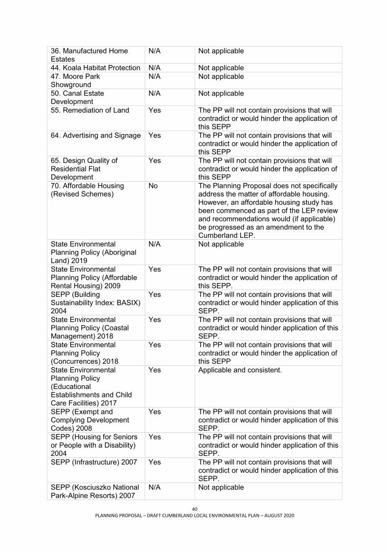
40 PLANNING PROPOSAL – DRAFT CUMBERLAND LOCAL ENVIRONMENTAL PLAN – AUGUST 2020
36. Manufactured Home Estates
N/A Not applicable
44. Koala Habitat Protection N/A Not applicable 47. Moore Park Showground
N/A Not applicable
50. Canal Estate Development
N/A Not applicable
55. Remediation of Land Yes The PP will not contain provisions that will contradict or would hinder the application of this SEPP
64. Advertising and Signage Yes The PP will not contain provisions that will contradict or would hinder the application of this SEPP
65. Design Quality of Residential Flat Development
Yes The PP will not contain provisions that will contradict or would hinder the application of this SEPP
70. Affordable Housing (Revised Schemes)
No The Planning Proposal does not specifically address the matter of affordable housing. However, an affordable housing study has been commenced as part of the LEP review and recommendations would (if applicable) be progressed as an amendment to the Cumberland LEP.
State Environmental Planning Policy (Aboriginal Land) 2019
N/A Not applicable
State Environmental Planning Policy (Affordable Rental Housing) 2009
Yes The PP will not contain provisions that will contradict or would hinder the application of this SEPP.
SEPP (Building Sustainability Index: BASIX) 2004
Yes The PP will not contain provisions that will contradict or would hinder application of this SEPP.
State Environmental Planning Policy (Coastal Management) 2018
Yes The PP will not contain provisions that will contradict or would hinder application of this SEPP.
State Environmental Planning Policy (Concurrences) 2018
Yes The PP will not contain provisions that will contradict or would hinder the application of this SEPP
State Environmental Planning Policy (Educational Establishments and Child Care Facilities) 2017
Yes Applicable and consistent.
SEPP (Exempt and Complying Development Codes) 2008
Yes The PP will not contain provisions that will contradict or would hinder application of this SEPP.
SEPP (Housing for Seniors or People with a Disability) 2004
Yes The PP will not contain provisions that will contradict or would hinder application of this SEPP.
SEPP (Infrastructure) 2007 Yes The PP will not contain provisions that will contradict or would hinder application of this SEPP.
SEPP (Kosciuszko National Park-Alpine Resorts) 2007
N/A Not applicable

41 PLANNING PROPOSAL – DRAFT CUMBERLAND LOCAL ENVIRONMENTAL PLAN – AUGUST 2020
State Environmental Planning Policy (Kurnell Peninsula) 1989
N/A Not applicable
SEPP (Sydney Region Growth Centres) 2006
N/A Not applicable
SEPP (Mining, Petroleum Production and Extractive Industries) 2007
Yes The PP will not contain provisions that will contradict or would hinder application of this SEPP.
State Environmental Planning Policy (Miscellaneous Consent Provisions) 2007
N/A Not applicable
State Environmental Planning Policy (Primary Production and Rural Development) 2019
Yes The PP will not contain provisions that will contradict or would hinder the application of this SEPP
State Environmental Planning Policy (State and Regional Development) 2011
N/A Not applicable
State Environmental Planning Policy (State Significant Precincts) 2005
Yes The PP will not contain provisions that will contradict or would hinder application of this SEPP.
State Environmental Planning Policy (Sydney Drinking Water Catchment) 2011
N/A Not applicable
State Environmental Planning Policy (Sydney Region Growth Centres) 2006
N/A Not applicable
State Environmental Planning Policy (Three Ports) 2013
N/A Not applicable
State Environmental Planning Policy (Urban Renewal) 2010
Yes The PP will not contain provisions that will contradict or would hinder application of this SEPP.
State Environmental Planning Policy (Vegetation in Non-Rural Areas) 2017
Yes The PP will not contain provisions that will contradict or would hinder the application of this SEPP
State Environmental Planning Policy (Western Sydney Employment Area) 2009
Yes The PP will not contain provisions that will contradict or would hinder the application with this SEPP
State Environmental Planning Policy (Western Sydney Parklands) 2009
N/A Not applicable
Table 2 - Consistency with Clause 9.1 Ministerial Directions Direction Title Consistency Comment Employment and Resources 1.1 Business and Industrial Zones
Yes The PP will not have any impact on existing Business and Industrial Zones and as such remains consistent with this direction.

42 PLANNING PROPOSAL – DRAFT CUMBERLAND LOCAL ENVIRONMENTAL PLAN – AUGUST 2020
1.2 Rural Zones Yes The PP will not have any impact on existing rural zoning and as such remains consistent with this direction.
1.3 Mining, Petroleum Production and Extractive Industries
Yes The PP will not have any impact on Mining, Petroleum and Extractive Industries and as such remains consistent with this direction.
1.4 Oyster Aquaculture Yes The PP will not have any impact on Oyster Aquaculture and as such remains consistent with this direction.
1.5 Rural Lands N/A This direction is not applicable to local government areas in the Greater Sydney Region.
Environment and Heritage 2.1 Environment Protection Zones
Yes The PP will contain provisions that facilitate the protection and conservation of environmentally sensitive areas and as such is consistent with this direction.
2.2 Coastal Protection Yes The PP will not contain provisions that will contradict or would hinder application of State Environmental Planning Policy (Coastal Management) 2018, and as such remains consistent with this direction.
2.3 Heritage Conservation Yes The PP will not contain provisions that contradict or would hinder the facilitation of the conservation of heritage items and as such remains consistent with
2.5 Application of E2 and E3 Zones and Environmental Overlays in Far North Coast LEPs
N/A Not applicable
Housing, Infrastructure and Urban Development 3.1 Residential zones Yes Noting that the permissibility of RFBs is to
be removed from B4 zone. However, it is considered that the B4 zone is not a zone in which significant residential development is permitted and is focussed on mixed and commercial uses.
3.2 Caravan Parks and Manufactured Home Estates
Yes The PP will not have any impact on caravan parks and manufactured home estates and as such remains consistent with this direction.
3.3 Home Occupations Yes The PP will not have any impact on home occupations and as such remains consistent with this direction.
3.4 Integrating land use and transport
Yes The PP will not have any impact on integrating land use and transport and as such remains consistent with this direction.
3.5 Development Near Licensed Aerodromes
Yes The PP will not have any impact on regulated airports and defence fields and as such remains consistent with this direction.
3.6 Shooting Ranges Yes The PP will not have any impact on shooting ranges and as such remains consistent with this direction.

43 PLANNING PROPOSAL – DRAFT CUMBERLAND LOCAL ENVIRONMENTAL PLAN – AUGUST 2020
3.7 Reduction in non-hosted short term rental accommodation period
N/A This direction only applies to the Byron Shire Council.
Hazard and Risk 4.1 Acid sulphate soils Yes The PP will not have any impact on land
containing acid sulphate levels and as such remains consistent with this direction.
4.2 Mine Subsidence and Unstable Land
Yes The PP will not have any impact on land within a Mine Subsidence District or identified as unstable land and as such remains consistent with this direction.
4.3 Flood Prone Land Yes The PP will not have any impact on flood prone land and as such remains consistent with this direction.
4.4 Planning for Bushfire Protection
Yes The PP will not have any impact on bushfire prone land and as such remains consistent with this direction.
Regional Planning
5.1 Implementation of Regional Strategies
N/A Not applicable
5.2 Sydney Drinking Water Catchments
N/A Not applicable
5.3 Farmland of State and Regional Significance on the NSW Far North Coast
N/A Not applicable
5.4 Commercial and Retail Development along the Pacific Highway, North Coast
N/A Not applicable
5.5 - Revoked N/A
Revoked
5.6 - Revoked N/A Revoked 5.7 - Revoked N/A Revoked 5.8 Second Sydney Airport: Badgerys Creek
N/A Revoked August 2018
5.9 North West Rail Link Corridor Strategy
N/A Not applicable
5.10 Implementation of Regional Plans
Yes The PP will be consistent with this Ministerial Direction and the Regional Plan
5.11 Development of Aboriginal Land Council land
N/A Aboriginal Land SEPP does not apply.
Local Plan Making 6.1 Approval and Referral Requirements
Yes The PP will be consistent with this Ministerial Direction.
6.2 Reserving Land for Public Purposes
Yes The PP will be consistent with this Ministerial Direction.
6.3 Site Specific Provisions Yes The PP will be consistent with this Ministerial Direction.
Metropolitan Planning 7.1 Implementation of the Metropolitan Plan for Sydney 2036
Yes The PP will be consistent with this Ministerial Direction and the Metropolitan Plan

44 PLANNING PROPOSAL – DRAFT CUMBERLAND LOCAL ENVIRONMENTAL PLAN – AUGUST 2020
7.2 Implementation of Greater Macarthur Land Release Investigation
N/A Not applicable
7.3 Parramatta Road Corridor Urban Transformation Strategy
Yes The PP will not contain provisions that contradict or hinder the implementation of the PRCUTS and will be consistent with this Ministerial Direction.
7.4 Implementation of North West Priority Growth Area Land Use and Infrastructure Implementation Plan
N/A Not applicable
7.5 Implementation of Greater Parramatta Priority Growth Area Interim Land Use and Infrastructure Implementation
Yes The PP will not contain provisions that contradict or hinder the implementation of the Greater Parramatta Priority Growth Area. As such the PP remains consistent with this direction.
Plan 7.6 Implementation of Wilton Priority Growth Area Interim Land Use and Infrastructure Implementation
N/A Not applicable
Plan 7.7 Implementation of Glenfield to Macarthur Urban Renewal Corridor
N/A Not applicable
7.8 Implementation of Western Sydney Aerotropolis Interim Land Use and Infrastructure Implementation Plan
N/A Not applicable
7.9 Implementation of Bayside West Precincts 2036 Plan
N/A Not applicable
7.10 Implementation of Planning Principles for the Cooks Cove Precinct
N/A Not applicable

45 PLANNING PROPOSAL – DRAFT CUMBERLAND LOCAL ENVIRONMENTAL PLAN – AUGUST 2020
C Environmental, social and economic impact 7. Is there any likelihood that critical habitat or threatened species, populations or ecological communities or their habitats will be adversely affected? The Planning will not adversely affect critical habitat, threatened species, populations or ecological communities or their habitats. The Planning Proposal does not involve changes to zoning other than to implement the Parramatta Road Corridor Urban Transformation Strategy, to amend controls within the Auburn and Lidcombe Town Centres Strategies, and to implement targeted planning controls for the Woodville Road corridor. These areas are heavily urbanised and developed and are not known to support any such environmental values. Land currently zoned for public recreation, environmental conservation and/or waterways is to be retained without change and therefore the existing protection and management of this land will continue. No changes are proposed to the permissible land uses under the respective zonings and therefore there are no impacts from this. Land currently mapped under the respective existing LEPs located within the LGA for biodiversity (remnant vegetation) and as riparian lands and watercourses are also to be retained and so protected under the respective provision of the LEP. Similarly, the existing provisions of the current LEPs relating to biodiversity and riparian lands and watercourses are also to be adopted. Given the high level and broad nature of this Planning Proposal, and the minor changes in planning controls and provisions to achieve consistency, specific environmental impacts are difficult to assess but are considered to be limited. These impacts would be taken into consideration in detail at any future Development Application stage for a specific development. 8. Are there any environmental impacts and how will they be mitigated? The Planning Proposal will not result in any significant negative environmental effects. Given the high level and broad nature of this Planning Proposal, and the minor changes in planning controls and provisions to achieve consistency, specific environmental impacts are difficult to assess but are considered to be limited. These environmental impacts would be taken into consideration at any future Development Application stage. The Planning Proposal seeks to retain all existing planning controls of zoning, FSR, and building heights, except for specific places or situations. As such there will be few changes to the type and scale of development that could result. Significant place-based exceptions for which planning controls are intended are the Parramatta Road Corridor, specific sites along Woodville Road Corridor, and within the Auburn and Lidcombe town centres. These proposed changes to controls are to implement previous planning work of the NSW Government or through Council, for which the environmental impacts have been assessed and addressed. In general, for these place based exceptions, there may be some environmental impacts relating to, for example, solar access and overshadowing, noise, amenity, traffic related. Environmental impacts may be positive as well as negative. The ‘items of environmental heritage’ list as contained in Schedule 5 is to be updated based on a comprehensive LGA-wide heritage study of all such items in the LGA. All existing listed heritage items are to be retained for inclusion under Schedule 5 of the Cumberland LEP with the exception of nine items that have been assessed as no longer having heritage

46 PLANNING PROPOSAL – DRAFT CUMBERLAND LOCAL ENVIRONMENTAL PLAN – AUGUST 2020
significance, including those which have been demolished to warrant continued listing and so will be excluded. Further investigations of potential new items of environmental heritage are to be undertaken, and if any new items are confirmed for listing, will form a subsequent amendment to the Cumberland LEP. The Planning Proposal seeks to broadly retain existing LEP provisions, and associated mapping, for each of the environmental matters of salinity, acid sulfate soils, flood planning and stormwater management, earthworks, bushfire hazard reduction, and the buffer zone between industrial and residential zones. As such there will be no new impacts or implications associated with these provisions. Providing new objectives to the Floor Space Ratio, Height of Building, and Exceptions to Development Standards provisions to ensure that new developments are appropriate to the place in which they are located, improve urban design outcomes and the resulting amenity for the wider community. The Planning Proposal introduces a new provision under Part 6 of the LEP relating to urban heat management to reduce, remove or mitigate urban heat resulting from new developments and alterations to existing developments of specified types. Considerations within developments include materials, design to improved thermal performance, awnings, green infrastructure and open space. As such these provisions are to reduce the need for mechanical heating and cooling, enhance greening, and manage heat generation, and would mitigate potential environmental impacts of the development. 9. Has the Planning Proposal adequately addressed any social and economic impact? The Planning Proposal is not expected to result in any significant negative economic or social impacts. The Planning Proposal will generally not result in substantial changes to zoning or development potential within the LGA. As this Planning Proposal is applicable to the entire LGA, but no plans or concepts of the outcomes are available, the social and economic impacts can only be generally indicated and would be minor and consistent with what could currently occur through redevelopment applying existing controls. However, there are specific sites, for which previous strategic planning work has been done and decisions made, which will be implemented under this Planning Proposal. The specific social and economic impacts of these have been assessed as part of that earlier work and are summarised below. Some changes to land use zones, building height, and FSR, and therefore development type and potential, are nominated within the Parramatta Road Corridor, at 264 Woodville Road and other specific sites along Woodville Road, and the Auburn and Lidcombe Town Centres as a result of and so to implement separate strategic planning projects. Details on these are provided below. The Auburn and Lidcombe Town Centres project, initiated by the Strategy for these
centres, is aimed at renewing and re-invigorating these two places by aligning building heights to FSRs so at to improve development feasibility and so encourage reinvestment into these centres as well as to improve built form outcomes. As such, their economic activity should be enhanced through new developments and associated commercial opportunities and increased local population. Only targeted changes to FSR (as development potential/yield) or zoning are proposed under this aspect, there are expected to be few social or economic impacts. There are anticipated to be social implications of this new and expanded residential and commercial activity.

47 PLANNING PROPOSAL – DRAFT CUMBERLAND LOCAL ENVIRONMENTAL PLAN – AUGUST 2020
The Planning controls for the Merrylands East Local Centre at 264 Woodville Road, will
enable commercial and residential uses on this site. A community hub including public open space is also to be provided as part of the development. A detailed assessment of the social and economic impacts was undertaken as part of the merit assessment process for that planning proposal. In general, project will provide additional housing, employment opportunities, and public parks, for the development and the local community, in a location serviced by transport and accessible to the wider higher order centres of Merrylands and Granville.
Changes are needed to zoning and associated height and FSR controls for specific areas along the Woodville Road Corridor – to implement new controls to accommodate existing higher density developments that were permissible under previous controls but are not permitted under the existing lower residential density zone. These changes will provide consistency of controls and fairness to other properties / owners, such as between higher density developments, which currently are not able to redevelop to the same scale. As these affect existing developments, minimal social or economic impacts are anticipated.
The Parramatta Road Corridor Urban Transformation (Strategy) project of the NSW Government is to be implemented by relevant councils under the s9.1 Ministerial direction. The Parramatta Road Corridor Urban Transformation Strategy and associated Parramatta Road Corridor Implementation Took Kit guides the future land use change for the corridor through additional homes, new employment opportunities, access to transport and provision of public places.
In particular the planning proposal introduces the B1 Neighbourhood Centre zoning for proposed small centres and a B6 zoning along St Hilliers Road, consistent with this Strategy for the Auburn precinct in particular, that will provide local shops and service, and employment opportunities for that increased local population and reinvigorate and support the area generally. An Economic Analysis Report and a Social Infrastructure Analysis Report were produced as background reports that informed the Strategy and its planning controls. The controls are to reinforce and support the existing and future business activities in these areas, and specific amenity improvements are nominated to support those businesses.
The requested rezonings by state agencies are for specific lots only, typically small in size, and have either been identified as surplus to requirements or are to achieve consistency in zoning of required lands for ongoing operational purposes. For those lands identified as surplus, it is intended these will be rezoned consistent with the adjacent land zoning and being small in area would have a very minor impact.
Providing new objectives to the Floor Space Ratio, Height of Building, and Exceptions to Development Standards provisions to ensure that new developments are appropriate to the place in which they are located, improve urban design outcomes, and the resulting amenity for the wider community. The significant employment and innovation lands of the LGA will be maintained and protected in retaining all currently zoned industrial lands and the majority of business (B) zoned land in the LGA. and by providing an ‘open’ permissibility of land uses ie permitting with consent those not explicitly identified as not permissible, for the IN1, IN2, and most Business ‘B’ zoned lands. This approach will also enable some non-traditional, innovative, and emerging industries to be considered as uses within those zones. This approach would support the implementation of Cumberland Employment and Innovation Lands Strategy

48 PLANNING PROPOSAL – DRAFT CUMBERLAND LOCAL ENVIRONMENTAL PLAN – AUGUST 2020
(EILS) and associated Land Use Planning Framework, being a background study to inform this Planning Proposal and the Cumberland LEP. The Planning Proposal seeks to allow (make permissible) seniors housing in the B4 Mixed Use zone. This is to recognise aging of the population, but who may still be independent, and their need for proximity to services, shops, conveniences, transport and so also accessible to the wider area (transport) and places of interest etc. This type of housing not only provides accommodation for this group of the population, but also the social and economic benefits. Furthermore, as this zoning is often in town centres, this provision would also allow the employment opportunities of this housing type in locations accessibly by public transport. The Planning Proposal does not specifically address the matter of affordable housing, however an affordable housing study has been commenced as part of the Cumberland LEP preparation project and recommendations would (if applicable) be progressed as an amendment to the Cumberland LEP (ie. a later stage activity) when any such inclusion can be given greater time to consider and address this important matter. The planning proposal seeks to permit places of public worship within R3 and R4 zones, in addition to the industrial zones, so that such places are located in the vicinity of and accessible by the community, with an additional objective for those zones to manage any impacts and protect the amenity of those residential areas.

49 PLANNING PROPOSAL – DRAFT CUMBERLAND LOCAL ENVIRONMENTAL PLAN – AUGUST 2020
D State and Commonwealth interests 10. Is there adequate public infrastructure for the Planning Proposal? Access to public infrastructure has been considered in the Planning Proposal. It is considered that the Planning Proposal will not create significant additional demand for public infrastructure given that the Planning Proposal will generally not result in substantial changes to development potential. Where changes are proposed that will result in development potential, such as specific areas along Woodville Road, and the Auburn and Lidcombe town centres, these have been considered under their respective specific planning projects, and will be more intensely assessed as part of future development applications that seek to utilise the applicable planning controls, as will development in any location within the LGA. With specific reference to the Parramatta Road Urban Transformation Strategy, an Infrastructure Schedule was produced that outlines the transport, community and open space infrastructure works to support the implementation of that Strategy, and includes works to be undertaken by Council or in conjunction with the state government through mechanisms including the developer contributions plans and redevelopment. These will be progressed with respect of funding availability, per need, and /or as redevelopment occurs. This Planning Proposal will be provided to public agencies and placed on public exhibition, and infrastructure provides will be able to make a submission to Council. The Planning Proposal does not include any Greenfield sites as future development areas and as such there is already substantial public infrastructure located across the LGA to support and provide a basis for expansion to support growth that may result under the existing controls. 11. What are the views of State and Commonwealth public authorities consulted in accordance with the Gateway Determination? State and Commonwealth public authorities were consulted in accordance with the Gateway Determination and given at least 21 days to comment on the proposal. State agencies were notified of the exhibition, including:
Transport for NSW Roads and Maritime Services Sydney Trains City of Parramatta Council Department of Premier and Cabinet – NSW Heritage Environment, Energy and Science Group Sydney Water Water NSW Western Sydney Local Health District
State agencies (Sydney Water and Sydney Trains/RailCorp) made submissions to Council during the preliminary consultation period to seek rezoning of small land parcels that were either identified as surplus to requirements or for consistency with other land holding zonings. Many of these specific rezoning submissions have been accommodated within this Planning Proposal. Transport for NSW made a submission in response to the statutory exhibition of the Planning Proposal, providing collated comments from across the Transport cluster (including Roads

50 PLANNING PROPOSAL – DRAFT CUMBERLAND LOCAL ENVIRONMENTAL PLAN – AUGUST 2020
and Maritime Services and Sydney Trains). In particular, TfNSW advised that consideration of the additional public infrastructure associated with the targeted changes to planning controls at selected locations, including Auburn Town Centre, Lidcombe Town Centre, Parramatta Road Corridor, and Woodville Road Corridor should be undertaken as part of the LEP process, and not left to the development application stage.
Council will continue to work with TfNSW to demonstrate that the proposed changes within the Parramatta Road Corridor will result in no net increase to traffic generation, prior to finalisation of the LEP (in accordance with condition 2 of the Gateway Determination). Should TfNSW ultimately not agree to support the targeted changes to planning controls at selected locations along the Parramatta Road Corridor, these sites will be removed from the planning proposal for the Cumberland LEP prior to finalisation.
A submission was also received from Western Sydney Local Health District. The submission commended Council on the overall objectives and controls outlined in the LEP and provided general feedback on a range of areas.
A submission was received from Water NSW advising that they have no comments on the draft LEP as they do not own or manage land in the area.
PART 4 MAPPING Mapping will be prepared as part of this Planning Proposal. The maps will consolidate existing mapping from the Auburn, Holroyd and Parramatta LEPs into the new Cumberland LEP. The mapping will be consistent with requirements of the Department of Planning, Industry and Environment. Attachment 1 and 14 to this details the site specific amendments to planning controls to be included in the new Cumberland LEP.

51 PLANNING PROPOSAL – DRAFT CUMBERLAND LOCAL ENVIRONMENTAL PLAN – AUGUST 2020
PART 5 COMMUNITY CONSULTATION On 23 March 2020, the Department of Planning, Industry and Environment issued a Gateway Determination granting Council permission to publicly exhibit the Planning Proposal.
The Planning Proposal was publicly exhibited for a six week period from 1 April 2020 to 8 May 2020. Information was made available on Council’s website, with a letter and brochure posted to properties in Cumberland City. Phone enquiries were answered by Council officers, and virtual book-in sessions were also available for detailed discussions on the LEP. Due to the COVID-19 pandemic, physical copies of the documents were not provided at the administration centres and libraries as these facilities were closed during this time.
A total of 222 individual submissions on the draft LEP were received in response to the public exhibition. Council officers also fielded numerous phone calls during the exhibition period, assisting residents and stakeholders with their enquiries. Further information on the submissions is provided below.
Of the total submissions received, 53 were from church groups and community members raising concerns about the proposed planning controls for places of public worship. Overwhelmingly, the submissions objected to the proposed changes to land use permissibility and implications for the continued operation and potential future expansion of established sites. A number of submissions also raised concerns about the proposed 2,000 sq.m minimum lot size requirement for new places of public worship in the R3 and R4 zones and the likely constraints this would place on church groups supporting the community.
Review of proposed planning controls for places of public worship
A further review of the proposed planning controls for places of public worship was undertaken by Council officers in response to the public submissions. Whilst there is genuine concern about the potential prohibition of places of public worship in certain zones, some parties may be unclear in the application of existing use rights provisions and how these laws protect places of public worship with a valid development consent.

52 PLANNING PROPOSAL – DRAFT CUMBERLAND LOCAL ENVIRONMENTAL PLAN – AUGUST 2020
Council considered a number of pathways in relation to planning controls for places of public worship where the new Cumberland LEP would prohibit its use, as shown in the figure below. This includes the following:
Existing places of public worship with a valid development consent in prohibited zones have existing use rights, where minor works are permitted within the existing site.
Expansion of places of public worship with a valid development consent in prohibited zones could have a targeted expansion if an additional clause is included in the new Cumberland LEP.
New places of public worship and other proposals in prohibited zones could pursue an owner-initiated planning proposal; however, this would need to follow the usual processes and would require support from Council.
Ultimately Council adopted the draft planning controls for places of public worship, as exhibited. This approach is consistent with advice from the Cumberland Local Planning Panel on 20 June 2020, which indicated the Panel:
Supports places of public worship as a prohibited use in the R2 Low Density Residential zone.
Believes existing use rights provide sufficient protection for all existing places of public worship.
Supports the minimum site area of 2000m2 for places of public worship in the R3 Medium Density Residential zone and R4 High Density Residential zone.
Post exhibition review and amendments to Planning Proposal Following the completion of the public exhibition process, a detailed review was undertaken. This review considered submissions received and other items identified by Council, including the Council officer response to the Cumberland Local Planning Panel’s advice, administrative items associated with the LEP, and various site specific requests for zoning

53 PLANNING PROPOSAL – DRAFT CUMBERLAND LOCAL ENVIRONMENTAL PLAN – AUGUST 2020
and/or planning control amendments. Further details are provided in the Council Report C07/20-501 and supporting documentation at Attachment 1. Amendments following advice from Cumberland Local Planning Panel The Planning Proposal has been updated following consideration of advice from the Panel to include the following amendments in the new Cumberland LEP:
i. Preliminary matters Aims of the plan – include an additional aim ‘To encourage and promote development that is environmentally sustainable’.
ii. Principal development standards Building heights and FSRs – include an additional objective ‘To minimise the visual impact of development and ensure sufficient solar access and privacy for neighbouring properties is achieved’.
iii. Miscellaneous provisions Miscellaneous permissible uses – increase gross floor area of kiosks to 50sqm. Architectural roof features – delete objective ‘e’ as it does not encourage innovation in roof design.
Administrative amendments The Planning Proposal has been updated following further review and consideration by Council to include the following administrative amendments in the new Cumberland LEP:
i. Additional exclusions to be added to Clause 4.6 of Cumberland LEP: clause 2.5 (additional permitted uses for particular land) clause 2.6(2) (subdivision of secondary dwellings not permitted) clause 2.8(3) (heads of consideration for the temporary use of land) clause 3.2 (complying development references contained within the LEP) clause 3.3(f) (environmentally sensitive areas exclusions) clause 5.19 (pond based, tank based and oyster aquaculture permitted
without consent in certain zones) clause 6.1 (acid sulphate soils – where consent is required and not required) clause 6.20 (urban heat management – heads of consideration for granting of
development consent) Schedule 1 – additional permitted uses (these standards are used to
determine the permissibility of specific development types) Schedule 3 – complying development (complying development references
contained within the LEP)
ii. Include office premises as a land use that is permitted with consent in the B6 Enterprise Corridor zone, to provide a consistent approach across the Cumberland area and carryover a permissible land use in the current Auburn and Parramatta LEPs.
iii. Include home businesses as a land use that is permitted with consent in the RE1 Public Recreation and RE2 Private Recreation Zones, to provide continued opportunities for existing dwellings.
iv. Include residential flat buildings as a land use that is permitted with consent in the B2 Local Centre and B4 Mixed Use zones, to provide a range of development opportunities and ensure our town centres are vibrant and inclusive places for the community.

54 PLANNING PROPOSAL – DRAFT CUMBERLAND LOCAL ENVIRONMENTAL PLAN – AUGUST 2020
v. Amend the minimum lot size for attached dual occupancies to 550 sq.m in the R2
Low Density zone and 530 sq.m in the R3 Medium Density zone, and allow Torrens Title subdivision.
vi. Include a minimum lot size of 600 sq.m for attached dual occupancies in the R2 Low Density and R3 Medium Density zones, and allow Torrens Title subdivision.
vii. Carry over the Auburn LEP approach for floor space ratio controls in the R2 Low Density zone (ie. no FSR).
viii. Allow an increase to the existing height of buildings controls in the R4 High Density Residential, B2 Local Centre and B4 Mixed Use zones of an additional 7 metres (2 additional levels) for all proposed developments whereby the Affordable Housing component (in accordance with State Environmental Planning Policy (Affordable Rental Housing) 2009) is 50% or more and an increase of 3.5 metres (1 additional level) where the Affordable Housing component is less than 50%. Development must be for a land use of Shop Top Housing, Residential Flat Buildings or Boarding Houses only where permissible.
ix. Allow an increase to the existing height of buildings controls in the B1 Neighbourhood Centre and R3 Medium Density Residential zones of approx. 3.5 metres (1 additional Level) for all proposed developments containing an Affordable Housing component in accordance with the State Environmental Planning Policy (Affordable Rental Housing) 2009. Development must be for a land use of Boarding Houses or Shop top Housing only where permissible.
x. Include land identified as ‘remnant native vegetation’ on the Biodiversity Map.
Minor site-specific amendments The Planning Proposal has been updated following further detailed review of planning controls and consideration of submissions to include the following site specific amendments in the new Cumberland LEP. These amendments are for minor zoning and/or planning control changes to address particular issues and anomalies, and that will have only a minor impact on the overall plan. Site address Planning Proposal
approach Reasons
Mays Hill and Finlayson Transitway Precincts
Retain B6 zoning for Mays Hill and Finlayson Transitway Precincts and include a local provision to allow shop-top housing, consistent with DCP controls
Intent of existing DCP controls is that shop top housing is permitted in this location
Merrylands Town Centre (Neil St and Merrylands Rd)
Rezone B6 zoned land in Merrylands Town Centre (224-240 Pitt St, 4 Terminal Pl, 2-6 Gladstone St, 15 Neil St, 17 Neil St, Merrylands) to B4
Site is in town centre core, prohibiting residential development appears to be an unintended consequence of this harmonisation

55 PLANNING PROPOSAL – DRAFT CUMBERLAND LOCAL ENVIRONMENTAL PLAN – AUGUST 2020
B6 Zone (Great Western Highway / Pendle Way)
Rezone B6 land at intersection of Great Western Highway and Pendle Way to B1 (no change to height and FSR)
Inconsistent application of B6 zone under draft Cumberland LEP
B6 Zone (Parramatta Road Corridor)
Update mapping of Clause 4.4(2B) to reflect revised boundary of B6 zone along Parramatta Road Corridor – ie. to exclude proposed B1 zone under draft Cumberland LEP
Clause 4.4(2B) provides an FSR incentive for certain types of development within the B6 zone (registered clubs, function centres, entertainment facilities, specialised retail premises, office premises and hotel/motel accommodation)
Octavia Street and Toongabbie Road
R2 to R4 (Octavia St) with corresponding increase in height and FSR R3 to R4 (Toongabbie Rd) with corresponding increase in height and FSR
Minor zoning anomaly in the context of surrounding land. Within walking distance of local centre and train services
55 Fox Hills Crescent, Toongabbie
Include ‘health services facility’ as an Additional Permitted Use on part of the site
Minor impact with inclusion of additional permitted use, supporting the provision of health related services in the Cumberland area
11-13 Bransgrove Street & 4-8 Irwin Place, Wentworthville
R2 to R4 with corresponding increase in height and FSR
Minor zoning anomaly in the context of surrounding land Within walking distance of local centre and high frequency bus services
Merrylands Road, Burnett Street and Ruth Street, Merrylands
Review height and FSR controls (Merrylands Road B1 zone) R2 to B1 with corresponding changes to height and FSR (Burnett Street and Ruth Street)
Minor zoning anomaly in the context of surrounding land Located in neighbourhood centre with bus services accessing key centres
233-249 Merrylands Road, Merrylands
Review FSR controls Minor FSR anomaly in the context of application of planning controls on the site (town centre core)
242-252 Pitt Street, Merrylands
Proposed increase in HOB and FSR
Minor HOB and FSR change in the context of town centre. Located within walking distance to train services
246-260 Woodville Road, 2-16 Lansdowne Street and 19 Highland Street, Guildford
Clarifications on planning controls applicable on site, consistent with development concept for site
Request from property owner, consistent with strategic intent and development outcomes for Merrylands East centre

56 PLANNING PROPOSAL – DRAFT CUMBERLAND LOCAL ENVIRONMENTAL PLAN – AUGUST 2020
101-123 Parramatta Road and 58- 66 Adderley Street, Lidcombe
Permit ‘specialised retail premises’ as an additional permitted use on the Domayne holding
Minor impact with inclusion of additional permitted use, consistent with current land use activities and future plans for the site
Lidcombe Hospital precinct Identify three Nurses Quarters Buildings as individual heritage items
Request from property owner. Is in addition to existing State Heritage Listing and local heritage status of area
Lidcombe Anglican Church
Include ‘place of public worship’ as an Additional Permitted Use
Request from property owner to support proposed development outcomes for the site, consistent with ongoing discussions on the matter

57 PLANNING PROPOSAL – DRAFT CUMBERLAND LOCAL ENVIRONMENTAL PLAN – AUGUST 2020
PART 6 PROJECT TIMELINE The following project timeline is intended to be a guide only and may be subject to changes in response to the public consultation process and/or community submissions. This proposed timeline meets the Department’s expectation that the Planning Proposal and LEP finalisation can be sought in mid-2020. Step Task Date 1 Preparation of the draft Planning Proposal August 2019 2 Draft Planning Proposal report prepared and
presented to Council September 2019
3 Draft Planning Proposal considered by Cumberland Local Planning Panel
March 2020
4 Forward Planning Proposal to Department for Gateway Determination
March 2020
5 Gateway Determination received March 2020 6 Community Consultation on Planning Proposal April 2020 7 Consider submissions and review Planning Proposal May 2020 8 Report to Council July 2020 9 Submit to Department for finalisation Mid 2020