Update on DEP Funded Sediment Characterization and Design/Permitting of a Geiger Key Culvert

Prepared for: Prepared by: Lockheed Martin Corporation AECOM Latham, NY
Environment
Culvert and 2015 Construction Season Waste Characterization Soil Sampling Work Plan West Branch of Bloody Brook Bloody Brook Voluntary Cleanup Program Onondaga County, New York
October 2014
Prepared for: Lockheed Martin Corporation Syracuse, New York
Prepared by: AECOM Technical Services Northeast, Inc. 40 British American Boulevard Latham, New York 12110

ii
Contents
1.0 Introduction .................................................................................................................. 1
2.0 Soil Sampling Around Culverts ................................................................................... 2
2.1 Soil Sampling Locations .................................................................................................2 2.1.1 Brookview Lane ...............................................................................................2 2.1.2 Floradale Road ................................................................................................2 2.1.3 Pearl Street ......................................................................................................2 2.1.4 Town Gardens Drive ........................................................................................3
2.2 Sample Collection and Ground Surface Restoration ........................................................3
2.3 Field Observation and Documentation of Samples ..........................................................3
2.4 Analytical Protocols ........................................................................................................3
2.5 Quality Control Sample Collection ...................................................................................4
2.6 Data Validation ..............................................................................................................4
3.0 Waste Characterization Sampling ............................................................................... 5
3.1 Sample Collection ..........................................................................................................5
3.2 Collection of VOC samples .............................................................................................5
3.3 Field Sample Homogenization ........................................................................................5
3.4 Spoils ............................................................................................................................6
3.5 Ground Surface Restoration ...........................................................................................6
3.6 Field Observation and Documentation of Samples ..........................................................6
3.7 Sample Analysis ............................................................................................................6
4.0 Sample Handling and Equipment Decontamination ................................................... 7
4.1 Sample Identification ......................................................................................................7
4.2 Sample Containerization and Shipping ............................................................................7
4.3 Equipment Decontamination ...........................................................................................7
5.0 Investigation Derived Waste Management .................................................................. 8
6.0 Green and Sustainable Remediation ........................................................................... 9
7.0 Contingency Plan ....................................................................................................... 10
7.1 Weather Conditions ...................................................................................................... 10

iii
7.2 Sample Refusal or Limited Sample Recovery ................................................................ 10
7.3 Access ........................................................................................................................ 10
8.0 Schedule and Reporting ............................................................................................ 11

iv
List of Tables
1 Summary of Soil Classification and Analytical Data Adjacent to Brookview Lane, Floradale Road, Pearl Street, and Town Gardens Drive Culverts
2 Proposed Soil Investigation Samples Adjacent to Brookview Lane, Floradale Road, Pearl Street,
and Town Gardens Drive Culverts
List of Figures
1 Site Location Map
2 Brookview Lane Culvert Existing and Proposed Soil Sampling Locations
3 Floradale Road Culvert Existing and Proposed Soil Sampling Locations
4 Pearl Street Culvert Existing and Proposed Soil Sampling Locations
5 Town Gardens Drive Culvert Existing and Proposed Soil Sampling Locations
6 Proposed Waste Characterization Samples
List of Appendices
A Community Air Monitoring Program
B Traffic Control Plan
List of Acronyms
ASP – Analytical Services Protocol
BGS – below ground surface
CAMP – Community Air Monitoring Program
ELAP – Environmental Laboratory Accreditation Program
HASP – Health and Safety Plan
NYSDEC – New York State Department of Environmental Conservation
NYSDOH – New York State Department of Health
PPE – Personal Protective Equipment
USEPA – United States Environmental Protection Agency
VCA – Voluntary Cleanup Agreement
WBBB – West Branch of Bloody Brook

1
1.0 Introduction This Culvert and 2015 Construction Season Waste Characterization Soil Sampling Work Plan (Work Plan) has been developed by AECOM Technical Services Northeast, Inc. (AECOM) on behalf of Lockheed Martin Corporation (Lockheed Martin) and is being submitted to the New York State Department of Environmental Conservation (NYSDEC) for approval. This work plan describes the sample collection and analysis to be completed for soil adjacent to the West Branch of Bloody Brook (WBBB) in the vicinity of the culverts on Brookview Lane, Floradale Road, Pearl Street, and Town Gardens Drive, as well as sediment and soil samples to be collected and analyzed for the purpose of characterizing waste soils and sediments associated with the remedial activities planned for the 2015 construction season.
For the purposes of this Work Plan, the site is defined as that portion of the WBBB and the surrounding area commencing on the southern boundary of the New York State Thruway (Thruway) and ending at Onondaga Lake Parkway. A site location map has been included as Figure 1. The sampling activities will be performed pursuant to a Voluntary Cleanup Agreement (VCA) between Lockheed Martin and NYSDEC (Index #; D7-0001-01-09, effective July 20, 2002).
All sampling proposed in this Work Plan will be conducted in conformance to the site Community Air Monitoring Plan (CAMP), attached as Appendix A, the site Health and Safety Plan (HASP), available under separate cover, and where necessary when sampling in the roadway, the Traffic Control Plan, included as Appendix B.
2
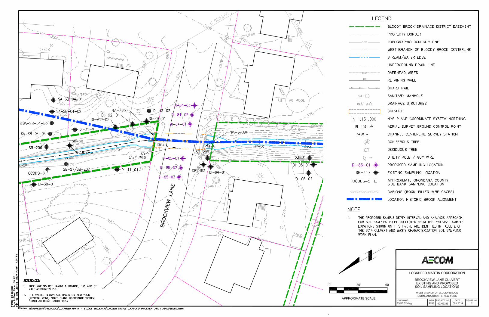
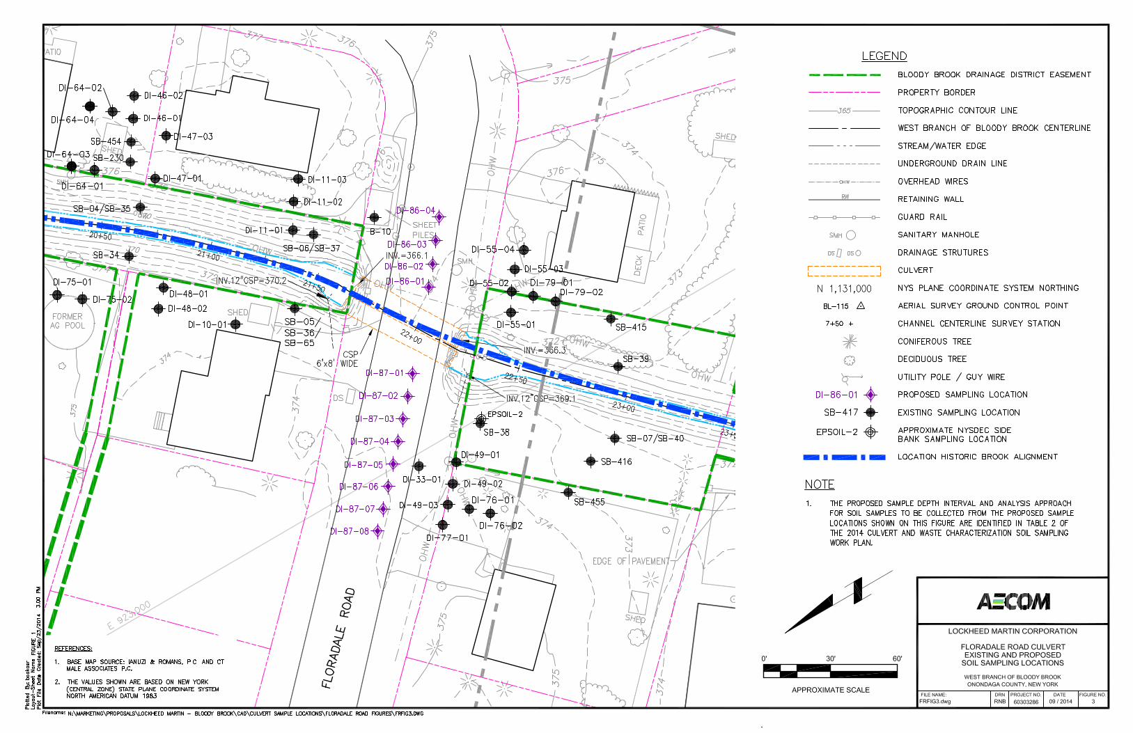
2.0 Soil Sampling Around Culverts This section of the Work Plan summarizes the proposed activities for the soil samples to be collected in the vicinity of the culverts that transfer the WBBB under Brookview Lane, Floradale Road, Pearl Street, and Town Gardens Drive. Samples were collected in the vicinity of the Sunflower Drive culvert on April 29, 2014 per the Sunflower Drive Water Main Replacement Soil Sampling Plan dated April 10, 2014. The objective of these sampling activities is to define the proper management of the soils that will be disturbed to allow for replacement of these culverts. This will be achieved using a flexible analysis approach consistent with previous sampling events and is further discussed below in Section 2.2. The proposed soil sample locations and depths were determined based on the existing analytical results adjacent to the culverts as well as the required distance from the edge of the culverts needed for construction purposes. The existing soil sample analytical data are summarized in Table 1 and the existing sample locations are shown on Figures 2 through 5. The location, number, and depth of soil samples are subject to change based on observations and physical conditions encountered during sampling activities and the ability of sampling personnel to safely collect a sample. Soil boring sampling activities around the culverts will be completed in conformance with the site CAMP (Appendix A), the Traffic Control Plan (Appendix B), and the site HASP.
The appropriate town and/or county officials will be contacted to obtain any necessary permits for working in the roadways.
2.1 Soil Sampling Locations This section summarizes the locations of soil samples to be collected from around the culverts.
2.1.1 Brookview Lane For the samples collected adjacent to the Brookview Lane culvert, 72 samples will be collected from six locations within the roadway and submitted to the laboratory for cadmium analysis (USEPA SW-846 Method 6010C). The proposed sample locations are shown on Figure 2. At the proposed locations, a sample will be collected from each 1-foot depth interval down to 12 feet, starting below the road pavement and sub-base (approximately 3-foot from road surface). Additional detail regarding sample collection, field procedures, analytical protocols and data validation are provided in the Sections 2.2 through 2.6.
2.1.2 Floradale Road For the samples collected adjacent to the Floradale Road culvert, 144 samples will be collected from 12 locations within the roadway and submitted to the laboratory for cadmium analysis (USEPA SW-846 Method 6010C). The proposed sample locations are shown on Figure 3. At the proposed locations, a sample will be collected from each 1-foot depth interval down to 12 feet, starting below the road pavement and sub-base. Additional detail regarding sample collection, field procedures, analytical protocols, and data validation are provided in Sections 2.2 through 2.6.
2.1.3 Pearl Street For the samples collected adjacent to the Pearl Street culvert, 108 samples will be collected from 9 locations within the parking lot and submitted to the laboratory for cadmium analysis (USEPA SW-846 Method 6010C). The proposed locations are shown on Figure 4. At the proposed locations, a sample will be collected from each 1-foot depth interval down to 12 feet, starting below the road pavement and sub-base. Additional detail regarding sample collection, field procedures, analytical protocol, and data validation are provided in Sections 2.2 through 2.6

3
2.1.4 Town Gardens Drive For the samples collected adjacent to the Town Gardens Drive culvert, 72 samples will be collected from 6 locations within the roadway and submitted to the laboratory for cadmium analysis (USEPA SW-846 Method 6010C). The proposed locations are shown on Figure 5. At the proposed locations, a sample will be collected from each 1-foot depth interval down to 12 feet, starting below the road pavement and sub-base. Additional detail regarding sample collection, field procedures, analytical protocol, and data validation are provided in Sections 2.2 through 2.6.
2.2 Sample Collection and Ground Surface Restoration Sample collection will be performed between the hours of 8:00 am and 5:00 pm, and every effort will be made to minimize any inconvenience (e.g., noise) to residents of the area. Sampling documentation will consist of detailed notes made during sampling activities that include recording of sample locations, sample depth, and site conditions (e.g., weather). Physical observations of the soil will be made for each 1-foot sample interval.
The samples will be collected using a direct push drill rig to drive the sampling tools into the formation to facilitate the soil sample collection. The samples will be collected in two-foot acetate sleeves. The sleeves will be removed from the sampling equipment and cut open to expose the soil sample. The sample will then be split into one-foot intervals and thoroughly mixed prior to placement in laboratory supplied sample containers. The samples will be collected and handled using new, disposable nitrile gloves. All down-hole equipment will be decontaminated as summarized in Section 4.3, and each of the borings will be abandoned with the excess soil by placing the soil back into the boring in same order it was removed. The road asphalt will be patched to cover the bore hole.
Following sample collection, select samples will be sent to the laboratory and analyzed, and other samples will be sent to the laboratory and held for possible future analysis depending on the results of the other samples. The analysis approach for each proposed sample is summarized in Table 2. Analysis of samples will be for cadmium using United States Environmental Protection Agency (USEPA) SW-846 Method 6010C.
2.3 Field Observation and Documentation of Samples Samples will be observed for physical properties such as color, sorting, grain size, etc. Field observations regarding each sample will be recorded on a field log. In addition, sampling documentation will consist of detailed notes made during sampling activities that include recording of sample locations, sample depth, and site conditions (e.g., weather). Physical observations of the soil will be made for each 1-foot sample interval. Sample locations will be marked and surveyed prior to demobilization from the site.
2.4 Analytical Protocols All samples collected pursuant to this Work Plan will be analyzed by a New York State Department of Health (NYSDOH) Environmental Laboratory Accreditation Program (ELAP) certified laboratory. The laboratory will provide a NYSDEC Analytical Services Protocol (ASP) Category B deliverable data package to allow for data validation.
To support the future validation data needs, quality control samples (blind field duplicate, matrix spike, and matrix spike duplicate samples) will be collected in the field and will be analyzed by the laboratory.

4
2.5 Quality Control Sample Collection Quality control samples will be collected to provide necessary data for future validation of the laboratory data. Blind field duplicates, matrix spike, and matrix spike duplicate samples will be collected at a frequency of one for every 20 samples collected.
Based on the quantity of proposed samples to be collected (i.e., 396 samples), approximately 20 blind duplicate, matrix spike, and matrix spike duplicate samples will be collected at locations to be determined in the field. Blind field duplicate samples will be created by collecting double volume for a sample location then splitting the sample volume between two sample containers to be used for the sample and the blind field duplicate sample. The matrix spike and matrix spike duplicate samples will be created by providing triple sample volume for a sample location then splitting the sample volume into three sample containers to be used for the sample, the matrix spike sample, and the matrix spike duplicate sample.
2.6 Data Validation The laboratory will provide a NYSDEC ASP Category B deliverable data package in order to allow for data validation. Copies of the laboratory reports will be forwarded to a third party data validator. The data validator will review the project quality control samples, holding times, and laboratory precision. A validation report will be obtained for each laboratory analytical report.

5
3.0 Waste Characterization Sampling This section provides the sampling procedures to be followed for the characterization of waste soils, including side bank soils and sediment associated with remedial activities planned for the 2015 construction season. Sampling and analysis of soil and sediment will be conducted in conformance with applicable regulatory requirements for waste characterization and the requirements of the permitted off-site treatment/disposal and/or recycling facility/facilities. Waste characterization activities will be conducted in accordance with the site CAMP (Appendix A) and HASP.
Soil and sediment samples will be collected from the proposed excavation areas to confirm that the excavated material meets the requirements of the receiving facility. Analytical methods, frequency of sampling, and method of sample collection are specified in the following sections.
3.1 Sample Collection
Sample collection will be performed between the hours of 8:00 am and 5:00 pm, and every effort will be made to minimize any inconvenience (e.g., noise) to residents of the area. Samples will be collected in accordance with the methods and frequency described herein. For the collection of each sample, material will be collected from five locations. Samples collected for volatile organic compound (VOC) analysis will be collected from one location per approximately 650 cubic yards (CY), which is about one sample per 1,000 tons of soil for the site. All other samples will be collected from four locations per 650 CY and homogenized into one sample per 650 CY. Methods for VOC sample collection are further discussed in Section 3.2. Homogenization of soil and sediment for analyses other than VOCs is described in Section 3.3. Figure 6 provides the proposed sample location points for each area within the excavation limits.
3.2 Collection of VOC samples
Soil and sediment to be sampled for VOC analysis will be collected using appropriate sampling tools (e.g., stainless steel hand auger) from the proposed central sample location points shown on Figure 6. Samples will be collected from the average depth of excavation planned at each sample location. Specifically, a sample location within a 2-foot excavation will require a VOC sample collected from soils 1-foot below ground surface (bgs), a sample location within the 4-foot excavation will require a VOC sample collected from soils 2 feet bgs, and a sample location within a sediment excavation will require a sample from approximately midway between the surface of the sediment to the underlying clay layer within the brook. Samples will be collected using new, disposable nitrile gloves and placed directly into a sample jar provided by a New York State certified laboratory.
3.3 Field Sample Homogenization
Samples collected for analysis other than VOCs and listed in Section 3.9 will be field composited from four composite sample locations within each sampling area (Figure 6). Grab samples will be collected from each one-foot interval inside each soil sample location and from the sediment sample, where applicable. For example, a sample from a composite located within a four foot excavation area will require collection of a grab sample from the 0- to 1-foot, 1- to 2-foot, 2- to 3-foot, and 3- to 4-foot intervals. Collected grab samples will be transferred from the sampler to a large plastic bag and will be homogenized using new, disposable nitrile gloves. An appropriate mass of the homogenized material will be transferred to a laboratory-supplied sample container(s) for shipment to the laboratory. Samples will be stored and handled according to procedures outlined in this work plan.

6
3.4 Spoils
Soil collected from borings that are not sent to a laboratory for analysis will be placed in the open boring from which it came. The remaining void space left from the boring will be filled with sand or similar. Sediment collected from the stream and not sent to the laboratory will be placed back in the brook from the location it was removed. Caution will be taken to minimize disturbance to the sediment in the brook and to place the spoils in a manner that minimizes turbidity downstream of the sample location. Equipment and tools that have come in contact with samples and non-contact sampling equipment will either be disposed of after each use or will be decontaminated and re-used according to the procedure described in Section 4.3.
3.5 Ground Surface Restoration
All efforts will be made to limit the amount of surficial disturbance potentially caused by the sampling crew and equipment. At each soil sample location, a patch of the vegetative cover will be removed down to the root and set aside to be replaced on the surface of the sample location after the boring has been backfilled. Any damage that may occur to the vegetated areas where soil borings are advanced will be repaired and seeded following the completion of the field activities.
3.6 Field Observation and Documentation of Samples
Field observations regarding each sample will be recorded on a field log. In addition, sampling documentation will consist of detailed notes made during sampling activities that include recording of sample locations, sample depth, and site conditions (e.g., weather). Sample locations will be identified using a small flag or similar article and surveyed prior to demobilization from the site.
3.7 Sample Analysis Analyses conducted under this Work Plan will be conducted by a laboratory certified under the NYSDOH ELAP for the constituents to be analyzed and to the extent that such certification is available. The samples described in Section 3.1 will be submitted for laboratory analysis for the parameters presented in the table below.
Analyte(s) Analytical Method Sulfide (Reactive) SW-846-C7 Reactivity SW-846-C7 Ignitability SW-846-C7 TCLP RCRA 8 Metals SW-846-1311/SW846-7470 (Mercury); SW-846-
1311/SW-846-6010 (other RCRA metals)
PCBs SW-846-1311/SW-846-8082 TCLP SVOCs SW-846-1311/SW-846-8270 TCLP VOCs SW-846-1311/SW-846-8260 TCLP Pest/Herb SW-846-1311/SW-846-8081 Percent Solids SM-2540.B

7
4.0 Sample Handling and Equipment Decontamination This section summarizes the sample identification, containerization and shipping, and equipment decontamination activities for the soils sampling around the culverts and waste characterization sampling.
4.1 Sample Identification Collected samples will be identified on sample containers and chains of custody immediately following sample collection. The chain of custody will, at a minimum, identify the following:
A unique sample number;
The date the sample was collected;
The name of the project;
Analyses requested; and
Sampling personnel.
Sample identification for the samples to be collected from around the culverts will be identified using the labels assigned to the proposed sample locations shown on Figures 2 through 5 and the depth interval the sample was collected from. For example, the sample collected from the 0-to1-foot depth interval from proposed location DI-84-01 would be identified as “DI-84-01-0001.”
Sample identification for waste characterization samples will be as follows: “LMC-WBBB-WC-SAMPLENUMBER-DATE”, beginning with the sample number left off at from the previous waste characterization sampling. For example, the twentieth waste characterization sample (as numbered on Figure 6) collected on November 15, 2014 was identified as “LMC-WBBB-WC-020-111514.”
4.2 Sample Containerization and Shipping Prior to the soil sampling activities, sample containers will be pre-cleaned by the laboratory and delivered to the field representative. The field representative will place a label on the sample containers. As soil samples are collected, the label will be used to record the sample identifier, date and time of sample collection, and the name of the person collecting the sample. After the samples have been collected, they will be kept in a cooler with ice, as needed, and will be delivered to the laboratory under proper chain of custody.
4.3 Equipment Decontamination Field decontamination for both the soil sampling around the culverts and the waste characterization sampling will be minimized to the extent practical by using disposable equipment or pre-cleaned reusable equipment. However, as necessary, reusable sampling equipment will be decontaminated before use. The decontamination procedure will consist of a wash with a phosphate-free detergent and potable water, a potable water rinse, a 10% nitric acid rinse, and a final distilled water rinse. The decontaminated equipment will then be placed in a plastic bag or wrapped in aluminum foil to keep the equipment clean.

8
5.0 Investigation Derived Waste Management Decontamination wastewater will be containerized and transported to Veolia Environmental Services located at the Lockheed Martin Electronics Park facility for proper identification and disposal or to Bloody Brook construction site and treated using the on-site construction water treatment system. Used personal protective equipment (PPE) and general trash will be containerized and transported to the Lockheed Martin Electronics Park facility or the Bloody Brook construction site for proper disposal as de minims sampling waste.

9
6.0 Green and Sustainable Remediation As summarized in this section, the implementation of green and sustainable practices has been considered in the development of this Work Plan and will be utilized during the investigation activities. By using a hand auger instead of gas or diesel-powered drilling equipment to collect soil samples where possible, energy consumption will be minimized and less greenhouse gases or pollutants will be emitted. The use of less intrusive sampling equipment will also minimize disruption to the environment by preventing unintended damage of the groundcover and soil. In addition, vehicle idling will be reduced with the requirement that all vehicles and equipment will be shut off when not in use for more than five minutes. Mobilization and demobilization to and from the site by field personnel will be minimized, and car-pooling will be used when feasible. Material management and waste reduction practices will be implemented for the project. For example, paper usage and disposal/recycling will be minimized by requesting that all analytical data and analytical reports be delivered in an electronic format.
10
7.0 Contingency Plan This section of the Work Plan has been developed to identify steps that will be taken in response to events that may reasonably occur during this work. These events include weather conditions, sample refusal or limited sample recovery, and access.
7.1 Weather Conditions During heavy rainfall events, certain sampling points will not be accessible. Therefore, to protect the safety of sampling personnel, work activities will be cancelled on days where forecasts predict significant rainfall. Work will resume when the rain event stops. In addition, in the event that rainfall conditions result in restricted access to sampling locations (as determined in the field), work activities will be suspended until conditions improve. Similar work restrictions will apply during periods of heavy snowfall, and work will not be scheduled during periods of snow cover.
7.2 Sample Refusal or Limited Sample Recovery In the event that sampling equipment cannot penetrate the subsurface at the designated sampling location or where limited sample recovery will affect field and analytical data, at least three additional attempts will be made to advance the sampler within the same general location as that proposed in this Work Plan. In the event of refusal, limited sample recovery, or the presence of obstructions, Lockheed Martin will not collect the sample and will document the reason for not collecting it.
7.3 Access The soil sampling described herein will be conducted within the maintenance easements granted to Onondaga County and through the consent of private property owners. Lockheed Martin and Onondaga County have an access agreement to perform activities within the Bloody Brook Drainage District easement. However, many of the sampling locations are located outside of the maintenance easements granted to Onondaga County. Lockheed Martin will attempt to obtain access for the collection of soil samples at those locations.
If access to complete the scope of investigations described herein is denied, Lockheed Martin will consult with the NYSDEC regarding potential relocation of any affected sampling location(s). If relocation is not an option, Lockheed Martin will engage in discussions regarding access with the property owner(s) and may collect the sample(s) at a later date. If these discussions are unsuccessful, Lockheed Martin will notify the NYSDEC in accordance with paragraph XIV.C. of the VCA for assistance in obtaining access.
11
8.0 Schedule and Reporting Upon NYSDEC approval, implementation of this Work Plan will begin. Within 30 days of approval, Lockheed Martin will begin organizing the field team as well as begin contacting property owners to gain access for sampling activities. It is unknown how long it will take to obtain access; however, once access has been granted, Lockheed Martin anticipates that sampling activities will take approximately one to two weeks to complete. Lockheed Martin will verbally communicate progress, schedule, and potential access issues to the NYSDEC Project Manager and summarize the activities in the monthly project progress reports.
For the samples collected from around the culverts, the laboratory data package will be forwarded for data validation after all the sampling results are available from the laboratory (approximately two weeks following the last sample collected). Following receipt of the data validation report(s), Lockheed Martin will develop and provide to NYSDEC a report including a table and a figure summarizing the results from the samples collected from around the culverts. In addition, Lockheed Martin will provide to each property owner the sampling results from their property.
For the waste characterization samples collected to facilitate the remedial activities planned for the 2015 construction season, Lockheed Martin will develop and provide to NYSDEC a report including a table and a figure summarizing the sampling activities and the analytical results.

TABLES

Boring ID Sampling Interval Analyte
Surface Elevation
(ft)
Brook Elevation
(ft)
Sample Elevation at Bottom of Interval (ft)
Sample Relation to
Brook Level
General Soil Classification Collection Date Result (mg/kg)
0' - 1' Cadmium 370.42 374.75 Above Clayey silt, sandy silt 4/28/2011 13.11' - 2' Cadmium 370.42 373.75 Above Sandy silt, silt 4/28/2011 0.29 J [0.74 J]2' - 3' Cadmium 370.42 372.75 Above Silty clay 4/28/2011 0.24 J3' - 4' Cadmium 370.42 371.75 Above Silty clay 4/28/2011 0.24 J0' - 1' Cadmium 370.41 375.96 Above Clayey silt, silty sand 4/28/2011 0.351' - 2' Cadmium 370.41 374.96 Above Silty clay 4/28/2011 0.23 J0' - 1' Cadmium 370.53 375.35 Above Silt, fine sand with some silt at 3" 4/28/2011 0.371' - 2' Cadmium 370.53 374.35 Above Silty sand 4/28/2011 0.502' - 3' Cadmium 370.53 373.35 Above Sandy silt 4/28/2011 0.19 J3' - 4' Cadmium 370.53 372.35 Above Sandy silt 4/28/2011 0.22 J0' - 1' Cadmium 370.44 374.54 Above Clay and silt, some sand and gravel 6/5/2013 31.2 J [16.6 J]1' - 2' Cadmium 370.44 373.54 Above Silty clay, some sand and gravel 6/5/2013 0.730' - 1' Cadmium 370.52 374.92 Above Clay and silt, some sand and gravel 6/5/2013 6.11' - 2' Cadmium 370.52 373.92 Above Silty clay, some sand and gravel 6/5/2013 2.80' - 1' Cadmium --- --- --- Topsoil 11/2002 45.81' - 2' Cadmium --- --- --- Sandy Silt 11/2002 2332' - 3' Cadmium --- --- --- Sandy Silt 11/2002 71.43' - 4' Cadmium --- --- --- Silty Sand 11/2002 125
SB-27 0" - 2" Cadmium --- --- --- --- --- 06/2002 11.90" - 6" Cadmium --- --- --- --- 10/1996 26.40" - 6" PCBs --- --- --- --- 10/1996 0.1930' - 1' Cadmium --- --- --- Silty Sand 11/2002 7.81' - 2' Cadmium --- --- --- Clayey Silt 11/2002 10.92' - 3' Cadmium --- --- --- Clayey Silt 11/2002 4.53' - 4' Cadmium --- --- --- Clayey Silt/Peat 11/2002 1390' - 1' Cadmium 370.79 375.03 Above Clayey silt, sandy silt, silty sand 4/28/2011 1.01' - 2' Cadmium 370.79 374.03 Above Sandy silt, silty sand 4/28/2011 0.892' - 3' Cadmium 370.79 373.03 Above Sandy silt, silty sand, clayey silt 4/28/2011 0.323' - 4' Cadmium 370.79 372.03 Above Sandy silt, silty sand, clayey silt 4/28/2011 0.11 J [0.17 J]0' - 1' Cadmium 370.63 372.64 Above Clayey silt, silt 4/28/2011 0.19 J1' - 2' Cadmium 370.63 371.64 Above Clayey silt, silty clay 4/28/2011 0.22 J2' - 3' Cadmium 370.63 370.64 At Silty clay, clay 4/28/2011 0.13 J3' - 4' Cadmium 370.63 369.64 Below Silty clay, clay 4/28/2011 0.15 J0" - 6" Cadmium --- --- --- --- 10/1996 0.140" - 6" PCBs --- --- --- --- 10/1996 <0.0250" - 2" Cadmium --- --- --- --- 11/2002 31.70' - 1' Cadmium --- --- --- Topsoil 11/2002 29.41' - 2' Cadmium --- --- --- Sandy Silt 11/2002 1.22' - 3' Cadmium --- --- --- Sandy Silt/Peat 11/2002 79.83' - 4' Cadmium --- --- --- Peat 11/2002 82.60" - 2" Cadmium 370.68 379.52 Above Topsoil 10/20/2003 <0.6540' - 1' Cadmium 370.68 378.69 Above Silty Sand 10/20/2003 <0.6131' - 2' Cadmium 370.68 377.69 Above Silty Sand 10/20/2003 <0.5892' - 3' Cadmium 370.68 376.69 Above Silty Sand 10/20/2003 <0.5663' - 4' Cadmium 370.68 375.69 Above Silty Sand 10/20/2003 <0.5724' - 5' Cadmium 370.68 374.69 Above Clay/Silt 10/20/2003 <0.5735' - 6' Cadmium 370.68 373.69 Above Clay/Silt 10/20/2003 <0.6106' - 7' Cadmium 370.68 372.69 Above Clay/Silt 10/20/2003 <0.5837' - 8' Cadmium 370.68 371.69 Above Clay/Silt 10/20/2003 <0.6298' - 9' Cadmium 370.68 370.69 At Clay/Silt 10/20/2003 7.84
9' - 10' Cadmium 370.68 369.69 Below Organic Silt/Sand 10/20/2003 <0.67110' - 11' Cadmium 370.68 368.69 Below Clay 10/20/2003 3.730" - 2" Cadmium 370.69 377.79 Above Topsoil 10/20/2003 <0.6770' - 1' Cadmium 370.69 376.96 Above Silty Sand 10/20/2003 <0.5971' - 2' Cadmium 370.69 375.96 Above Silty Sand 10/20/2003 <0.6022' - 3' Cadmium 370.69 374.96 Above Silty Sand 10/20/2003 <0.5863' - 4' Cadmium 370.69 737.96 Above Silty Sand 10/20/2003 <0.6024' - 5' Cadmium 370.69 372.96 Above Silty Sand to Sand 10/20/2003 <0.5735' - 6' Cadmium 370.69 371.96 Above Sand to Silty Sand 10/20/2003 <0.613 [<0.595]6' - 7' Cadmium 370.69 370.96 At Silty Clay to Organic Clayey Silt 10/20/2003 1397' - 8' Cadmium 370.69 369.96 Below Organic Silt/Sand 10/20/2003 1.738' - 9' Cadmium 370.69 368.96 Below Organic Silt/Sand 10/20/2003 11.9
376.96
375.75
DI-43-02
DI-43-01
376.35DI-44-01
---SB-207
DI-62-01
DI-62-02
375.54
375.92
---SB-60
---OCDDS-5
---OCDDS-6
376.03
373.64DI-31-01
DI-30-01
SA-SB-04-01
SA-SB-04-02
---SB-206
377.96
379.69
Table 1
Onondaga County, New YorkBloody Brook Voluntary Cleanup Program
West Branch of Bloody BrookSummary of Soil Classification and Analytical Data Adjacent to Brookview Lane, Floradale Road, Pearl Street, and Town Gardens Drive Culverts
Page 1 of 7

Boring ID Sampling Interval Analyte
Surface Elevation
(ft)
Brook Elevation
(ft)
Sample Elevation at Bottom of Interval (ft)
Sample Relation to
Brook Level
General Soil Classification Collection Date Result (mg/kg)
Table 1
Onondaga County, New YorkBloody Brook Voluntary Cleanup Program
West Branch of Bloody BrookSummary of Soil Classification and Analytical Data Adjacent to Brookview Lane, Floradale Road, Pearl Street, and Town Gardens Drive Culverts
0" - 2" Cadmium 370.70 376.89 Above Topsoil 10/20/2003 2.70' - 1' Cadmium 370.70 376.06 Above Silty Sand 10/20/2003 2.171' - 2' Cadmium 370.70 375.06 Above Silty Sand 10/20/2003 <0.5882' - 3' Cadmium 370.70 374.06 Above Silty Sand 10/20/2003 <0.5613' - 4' Cadmium 370.70 373.06 Above Silty Sand 10/20/2003 <0.6174' - 5' Cadmium 370.70 372.06 Above Silty Sand 10/20/2003 <0.6035' - 6' Cadmium 370.70 371.06 At Silty Sand 10/20/2003 <0.6356' - 7' Cadmium 370.70 370.06 Below Silty Sand to Organic Silt/Sand 10/20/2003 1,9207' - 8' Cadmium 370.70 369.06 Below Organic Silt/Sand 10/20/2003 1990" - 2" Cadmium 370.71 376.73 Above Topsoil 10/20/2003 7.40' - 1' Cadmium 370.71 375.90 Above Silty Sand 10/20/2003 5.31' - 2' Cadmium 370.71 374.90 Above Sandy Silt 10/20/2003 <0.622' - 3' Cadmium 370.71 373.90 Above Sandy Silt 10/20/2003 <0.563' - 4' Cadmium 370.71 372.90 Above Silty Sand 10/20/2003 <0.594' - 5' Cadmium 370.71 371.90 Above Silty Sand 10/20/2003 <0.585' - 6' Cadmium 370.71 370.90 At Silty Sand to Organic Silt/Sand 10/20/2003 84.76' - 7' Cadmium 370.71 369.90 Below Organic Silt/Sand 10/20/2003 1127' - 8' Cadmium 370.71 368.90 Below Silty Sand 10/20/2003 456
0.80' - 1.5' Cadmium --- --- --- --- 11/24/2003 0.971.5' - 7.5' Cadmium --- --- --- --- 11/24/2003 <0.590' - 1.5' Cadmium --- --- --- --- 11/24/2003 2
1.5' - 10' Cadmium --- --- --- --- 11/24/2003 2.50' - 1' Cadmium --- --- --- --- 11/24/2003 <0.62
1' - 10' Cadmium --- --- --- --- 11/24/2003 <0.570' - 1.5' Cadmium --- --- --- --- 11/25/2003 7
1.5' - 10' Cadmium --- --- --- --- 11/25/2003 0.950' - 1' Cadmium 369.96 376.21 Above Silt with little clay & little sand 4/25/2011 1.75' - 6' Cadmium 369.96 371.21 Above Silty clay with some fine sand 4/25/2011 0.296' - 7' Cadmium 369.96 370.21 At Clay with little silt (organics) 4/25/2011 1.47' - 8' Cadmium 369.96 369.21 Below Clay with little silt (organics) 4/25/2011 3328' - 9' Cadmium 369.96 368.21 Below Clay with little silt (organics) 4/25/2011 0.980' - 1' Cadmium 369.18 374.82 Above Fine sand with little silt 4/25/2011 1.41' - 2' Cadmium 369.18 373.82 Above Fine sand with little silt 4/25/2011 0.19 J2' - 3' Cadmium 369.18 372.82 Above Silt with some fine sand & trace clay 4/25/2011 0.243' - 4' Cadmium 369.18 371.82 Above Silt with some fine sand & trace clay 4/25/2011 0.254' - 5' Cadmium 369.18 370.82 Above Silt with some fine sand & trace clay 4/25/2011 0.475' - 6' Cadmium 369.18 369.82 Above Silt with little sand & little clay 4/25/2011 10.56' - 7' Cadmium 369.18 368.82 At Silt with little sand & little clay 4/25/2011 0.487' - 8' Cadmium 369.18 367.82 Below Gray clay at 7'-6" 4/25/2011 <0.26 U4' - 5' Cadmium 369.98 371.21 Above Silt with little clay 4/25/2011 0.20 J5' - 6' Cadmium 369.98 370.21 At Silt with little clay 4/25/2011 3.26' - 7' Cadmium 369.98 369.21 Below Silt with little clay 4/25/2011 0.26 J0' - 1' Cadmium 366.48 372.62 Above Silty clay, clayey silt 4/25/2011 5.5 B1' - 2' Cadmium 366.48 371.62 Above Silty clay, clay 4/25/2011 2.4 B0' - 1' Cadmium --- --- --- Silt & sand/ organics & gravel 8/14/2009 7.211' - 2' Cadmium --- --- --- Silt with sand/organics & clay 8/14/2009 6.382' - 3' Cadmium --- --- --- Silt with sand/clay & gravel 8/14/2009 3.763' - 4' Cadmium --- --- --- Silt with sand/clay & gravel 8/14/2009 490' - 1' Cadmium --- --- --- Silt with gravel/organics 8/14/2009 0.431 [0.276]1' - 2' Cadmium --- --- --- Silt with clay/gravel & organics 8/14/2009 0.062 J2' - 3' Cadmium --- --- --- Silt with gravel 8/14/2009 0.2663' - 4' Cadmium --- --- --- Silt 8/14/2009 0.2404' - 5' Cadmium --- --- --- Silt with gravel 8/14/2009 0.213 J5' - 6' Cadmium --- --- --- Silt with gravel 8/14/2009 0.074 J0' - 1' Cadmium --- --- --- Silt & clay/organics & gravel 8/14/2009 <0.2611' - 2' Cadmium --- --- --- Silt & clay/organics & gravel 8/14/2009 0.5232' - 3' Cadmium --- --- --- Silt with gravel/organics 8/14/2009 0.154 J3' - 4' Cadmium --- --- --- Silt with gravel/organics 8/14/2009 0.3274' - 5' Cadmium --- --- --- Silt with gravel/organics 8/14/2009 <0.2535' - 6' Cadmium --- --- --- Silt with gravel/organics, some sand 8/14/2009 0.061 J6' - 7' Cadmium --- --- --- Silt with gravel/organics, some sand 8/14/2009 <0.2437' -8' Cadmium --- --- --- Silt with gravel/organics, some sand 8/14/2009 <0.2508' - 9' Cadmium --- --- --- Silt/clay 8/14/2009 <0.2659' -10' Cadmium --- --- --- Silty clay/sand 8/14/2009 <0.235
10' - 11' Cadmium --- --- --- Silty clay/sand 8/14/2009 <0.267
DI-06-02
SA-SB-04-03
SA-SB-04-04
377.06
376.90
B-9
B-10
B-6
B-7
DI-04-01
DI-06-01
DI-11-01
DI-11-02
DI-10-01
DI-11-03
---
---
373.62
---
---
---
---
---
375.82
377.21
Page 2 of 7

Boring ID Sampling Interval Analyte
Surface Elevation
(ft)
Brook Elevation
(ft)
Sample Elevation at Bottom of Interval (ft)
Sample Relation to
Brook Level
General Soil Classification Collection Date Result (mg/kg)
Table 1
Onondaga County, New YorkBloody Brook Voluntary Cleanup Program
West Branch of Bloody BrookSummary of Soil Classification and Analytical Data Adjacent to Brookview Lane, Floradale Road, Pearl Street, and Town Gardens Drive Culverts
0' - 1' Cadmium 364.09 370.26 Above Fine sand, some gravel, organics 8/23/2011 1.41' - 2' Cadmium 364.09 369.26 Above Fine sand, some gravel, organics 8/23/2011 2.72' - 3' Cadmium 364.09 368.26 Above Fine sand, little silt, trace gravel 8/23/2011 0.303' - 4' Cadmium 364.09 367.26 Above Silty fine sand - silt increasing with depth 8/23/2011 0.354' - 5' Cadmium 364.09 366.26 Above Sandy silt to 4'-6" then silty clay 8/23/2011 0.19 J [0.14 J]5' - 6' Cadmium 364.09 365.26 Above Clay, trace silt 8/23/2011 0.22 J6' - 7' Cadmium 364.09 364.26 At Clay, trace silt 8/23/2011 0.16 J0' - 1' Cadmium 364.09 370.67 Above Fine sand, little gravel, trace silt (organics) 8/23/2011 4.61' - 2' Cadmium 364.09 369.67 Above Fine sand, some gravel, little silt (organics) 8/23/2011 2.32' - 3' Cadmium 364.09 368.67 Above Fine sand, little silt, trace gravel 8/23/2011 0.383' - 4' Cadmium 364.09 367.67 Above Silty sand, trace clay (mottling), trace gravel 8/23/2011 0.300' - 1' Cadmium 364.09 371.25 Above Fine sand, some gravel, organics 8/23/2011 0.911' - 2' Cadmium 364.09 370.25 Above Fine sand, some gravel 8/23/2011 0.072 J2' - 3' Cadmium 364.09 369.25 Above Fine sand, some gravel, organics 8/23/2011 0.253' - 4' Cadmium 364.09 368.25 Above Fine sand, some gravel, organics 8/23/2011 0.11 J4' - 5' Cadmium 364.09 367.25 Above Clayey silt, increasing clay with depth 8/23/2011 5.85' - 6' Cadmium 364.09 366.25 Above Silty clay to 5'-8" then silt 8/23/2011 1.16' - 7' Cadmium 364.09 365.25 Above Clayey silt 8/23/2011 <0.220' - 1' Cadmium 364.55 371.6 Above Silty sand, little gravel, trace clay 8/22/2011 0.621' - 2' Cadmium 364.55 370.6 Above Silty sand, little gravel, trace clay 8/22/2011 15.22' - 3' Cadmium 364.55 369.6 Above Silty sand, little gravel, trace clay 8/22/2011 183' - 4' Cadmium 364.55 368.6 Above Silty sand, little gravel, trace clay 8/22/2011 4.94' - 5' Cadmium 364.55 367.6 Above Silt, trace clay 8/22/2011 0.275' - 6' Cadmium 364.55 366.6 Above Silt, little clay 8/22/2011 0.21 J6' - 7' Cadmium 364.55 365.6 Above Silt, little clay 8/22/2011 0.19 J0' - 1' Cadmium 364.55 371.62 Above Silty sand & gravel, trace clay 8/22/2011 2.51' - 2' Cadmium 364.55 370.62 Above Silty sand & gravel, trace clay 8/22/2011 3.72' - 3' Cadmium 364.55 369.62 Above Sandy silt with little gravel, trace clay 8/22/2011 2.33' - 4' Cadmium 364.55 368.62 Above Sandy silt with little gravel, trace clay 8/22/2011 2.94' - 5' Cadmium 364.55 367.62 Above Silt, little clay (green & red mottling) 8/22/2011 1.55' - 6' Cadmium 364.55 366.62 Above Silt, little clay 8/22/2011 0.26 [0.20 J]6' - 7' Cadmium 364.55 365.62 Above Silt, little clay 8/22/2011 0.14 J0' - 1' Cadmium --- -- --- Gravel/silt and sand 8/11/2009 2.261' - 2' Cadmium --- -- --- Silty clay with gravel 8/11/2009 2.482' - 3' Cadmium --- -- --- Silty clay with gravel 8/11/2009 2.05 [2.74]3' - 4' Cadmium --- -- --- Silty clay with gravel/organics 8/11/2009 3.954' - 5' Cadmium --- -- --- Silty clay with gravel/organics 8/11/2009 2.730' - 1' Cadmium 365.46 370.98 Above Fine sandy silt, trace clay & organics 8/24/2011 22.01' - 2' Cadmium 365.46 369.98 Above Sandy silt, trace clay 8/24/2011 1012' - 3' Cadmium 365.46 368.98 Above Sandy silt, trace clay 8/24/2011 5.03' - 4' Cadmium 365.46 367.98 Above Silt 8/24/2011 0.510' - 1' Cadmium 365.46 371.31 Above Silt, some fine sand, little clay 8/24/2011 48.2 J1' - 2' Cadmium 365.46 370.31 Above Silt, little fine sand, little clay 8/24/2011 8.8 J2' - 3' Cadmium 365.46 369.31 Above Silt, little to trace clay 8/24/2011 23.2 J3' - 4' Cadmium 365.46 368.31 Above Silt, little fine sand, little clay 8/24/2011 15.6 J0' - 1' Cadmium 367.00 376.47 Above Clayey silt, silty clay, trace gravel 4/27/2011 3.61' - 2' Cadmium 367.00 375.47 Above Silty clay, clayey silt, gravel 4/27/2011 0.830' - 1' Cadmium 367.00 376.39 Above Clayey silt, silty clay, fine to coarse gravel 4/27/2011 0.791' - 2' Cadmium 367.00 375.39 Above Fine to coarse gravel, silty clay 4/27/2011 0.700' - 1' Cadmium 366.91 376.02 Above Clayey silt with little fine sand 4/26/2011 2.21' - 2' Cadmium 366.91 375.02 Above Clayey silt with little fine sand 4/26/2011 2.60' - 1' Cadmium 366.91 376.58 Above Clayey silt with little fine sand, trace gravel 4/26/2011 0.601' - 2' Cadmium 366.91 375.58 Above Clayey silt with little fine sand, trace gravel, less clay 4/26/2011 1.40' - 1' Cadmium 366.79 372.27 Above Silty clay, roots 4/25/2011 52.6 B1' - 2' Cadmium 366.79 371.27 Above Silty clay with clay 4/25/2011 9.6 B2' - 3' Cadmium 366.79 370.27 Above Silty clay with clay 4/25/2011 6.5 B3' - 4' Cadmium 366.79 369.27 Above Clay with silty clay 4/25/2011 9.8 B0' - 1' Cadmium 366.79 372.67 Above Clayey silt, sandy silt, silty sand 4/25/2011 0.311' - 2' Cadmium 366.79 371.67 Above Clayey silt 4/25/2011 0.095 J0' - 1' Cadmium 366.19 371.96 Above Clayey silt, clay, sandy silt 4/25/2011 4.3 B1' - 2' Cadmium 366.19 370.96 Above Silty clay, clay 4/25/2011 1.7 B2' - 3' Cadmium 366.19 369.96 Above Clay, silty clay, little gravel 4/25/2011 3.3 BJ [0.84 BJ]3' - 4' Cadmium 366.19 368.96 Above Clay, silty clay 4/25/2011 1.7 B0' - 1' Cadmium 366.18 372.23 Above Silty clay, clay, roots 4/25/2011 6.41' - 2' Cadmium 366.18 371.23 Above Silty clay, clay, coarse gravel 4/25/2011 6.8
372.31
372.6
DI-49-02
DI-15-01
DI-15-02
371.67
---
DI-13-03 372.25
DI-48-02
DI-48-01
DI-34-01 371.98
DI-34-02
372.62
DI-49-01
DI-13-01
DI-13-02
DI-33-01
DI-47-03
DI-47-01
DI-46-01
377.02
373.27
372.96
373.67
377.39
371.26
DI-46-02
377.58
377.47
373.23
Page 3 of 7

Boring ID Sampling Interval Analyte
Surface Elevation
(ft)
Brook Elevation
(ft)
Sample Elevation at Bottom of Interval (ft)
Sample Relation to
Brook Level
General Soil Classification Collection Date Result (mg/kg)
Table 1
Onondaga County, New YorkBloody Brook Voluntary Cleanup Program
West Branch of Bloody BrookSummary of Soil Classification and Analytical Data Adjacent to Brookview Lane, Floradale Road, Pearl Street, and Town Gardens Drive Culverts
0' - 1' Cadmium 366.18 372.62 Above Silty clay, clay, trace gravel 4/25/2011 0.781' - 2' Cadmium 366.18 371.62 Above Silty clay, clay, cobble 4/25/2011 10.70' - 1' Cadmium 366.19 372.13 Above Silty clay, clay 4/25/2011 2.6 B1' - 2' Cadmium 366.19 371.13 Above Clay 4/25/2011 1.5 B2' - 3' Cadmium 366.19 370.13 Above Clay, silty clay, clayey silt 4/25/2011 30.5 B3' - 4' Cadmium 366.19 369.13 Above Clayey silt, silt 4/25/2011 12.5 B0' - 1' Cadmium 366.21 372.56 Above Silty clay, clay, roots 4/25/2011 6.91' - 2' Cadmium 366.21 371.56 Above Clay 4/25/2011 1.52' - 3' Cadmium 366.21 370.56 Above Clay 4/25/2011 0.773' - 4' Cadmium 366.21 369.56 Above Clay 4/25/2011 12.40' - 1' Cadmium 366.22 373.18 Above Clay, silty clay, roots 4/25/2011 0.521' - 2' Cadmium 366.22 372.18 Above Silty clay, silt, trace gravel 4/25/2011 1.02' - 3' Cadmium 366.22 371.18 Above Silty clay, little sand 6/4/2013 1.93' - 4' Cadmium 366.22 370.18 Above Silty clay, little sand 6/4/2013 0.874' - 5' Cadmium 366.22 369.18 Above Clayey silt, some sand 6/4/2013 35.9
DI-55-04 4' - 5' Cadmium 365.88 369.93 Above Silty Clay, some sand 6/4/2013 20.30' - 1' Cadmium 365.18 370.75 Above Gravelly silt, little sand, trace clay 8/24/2011 15.61' - 2' Cadmium 365.18 372.18 Above Clayey silt 8/24/2011 0.30 J [1.4 J]2' - 3' Cadmium 365.18 372.18 Above Clayey silt, clay increases with depth 8/24/2011 1.83' - 4' Cadmium 365.18 372.18 Above Gray clay 8/24/2011 2.80' - 1' Cadmium 365.12 370.67 Above Sandy silt, some gravel, trace clay & organics 8/24/2011 26.3 J1' - 2' Cadmium 365.12 372.18 Above Clayey silt, trace fine sand, trace organics 8/24/2011 24.1 J [41.0 J]2' - 3' Cadmium 365.12 372.18 Above Clayey silt, clay increases with depth 8/24/2011 38.4 J3' - 4' Cadmium 365.12 372.18 Above Clay, trace silt 8/24/2011 61.3 J0' - 1' Cadmium 364.31 371.98 Above Fine sand 8/23/2011 1.81' - 2' Cadmium 364.31 372.18 Above Fine sand, little silt 8/23/2011 10.10' - 1' Cadmium 364.31 371 Above Silty sand 8/23/2011 17.91' - 2' Cadmium 364.31 372.18 Above Silty sand 8/23/2011 61.52' - 3' Cadmium 364.31 372.18 Above Silty sand, little clay 8/23/2011 23.13' - 4' Cadmium 364.31 372.18 Above Silty sand, some clay 8/23/2011 11.30' - 1' Cadmium 364.00 371.06 Above Clayey silt, some sand 6/4/2013 2.6 [2.1]1' - 2' Cadmium 364.00 370.06 Above Clay and silt, some sand 6/4/2013 10.82' - 3' Cadmium 364.00 369.06 Above Silty clay, some sand 6/4/2013 0.253' - 4' Cadmium 364.00 368.06 Above Silty clay, some sand 6/4/2013 16.34' - 5' Cadmium 364.00 367.06 Above Clayey silt, some sand, organics 6/4/2013 1.65' - 6' Cadmium 364.00 366.06 Above Silty clay, green mottling (organics) 6/4/2013 0.22 J1' - 2' Cadmium 364.00 370.32 Above Clay and silt, little sand 6/4/2013 7.13' - 4' Cadmium 364.00 368.32 Above Clayey silt, some sand, organics 6/4/2013 3.0
DI-58-05 1' - 2' Cadmium 364.00 364.32 Below Silt and Clay, some sand, trace gravel 8/13/2013 2.1 B0' - 1' Cadmium 365.22 371.12 Above Silt, little sand & clay 8/24/2011 31.71' - 2' Cadmium 365.22 372.18 Above Silt, little sand & clay 8/24/2011 3.42' - 3' Cadmium 365.22 372.18 Above Silt, little sand & clay 8/24/2011 3.13' - 4' Cadmium 365.22 372.18 Above Silt, little clay, trace sand, silt increases with depth 8/24/2011 28.60' - 1' Cadmium 365.16 371.14 Above Silty sand, trace clay 8/24/2011 83.7 J1' - 2' Cadmium 365.16 372.18 Above Silty sand, little clay 8/24/2011 10.4 J2' - 3' Cadmium 365.16 372.18 Above Silty sand, little clay 8/24/2011 14.3 J3' - 4' Cadmium 365.16 372.18 Above Fine sand, silt, trace clay 8/24/2011 11.0 J0' - 1' Cadmium 367.11 375.32 Above Clay and sandy silt, some gravel 6/4/2013 3.51' - 2' Cadmium 367.11 374.32 Above Sand, sandy silt and clay 6/4/2013 7.20' - 1' Cadmium 367.06 376.12 Above Silt and sand, trace gravel, organics 6/4/2013 4.51' - 2' Cadmium 367.06 375.12 Above Clay and silt, little sand 6/4/2013 0.940' - 1' Cadmium 367.07 375.86 Above Sand and Silt, trace gravel 8/13/2013 12.7 B1' - 2' Cadmium 367.07 374.86 Above Sand and Silt, trace gravel 8/13/2013 14.3 B2' - 3' Cadmium 367.07 373.86 Above Sand and Silt, trace gravel 8/13/2013 10.8 B3' - 4' Cadmium 367.07 372.86 Above Clayey Silt and Sand 8/13/2013 5.4 B
DI-64-04 0' - 1' Cadmium 377.39 367.03 376.39 Above Sand, some silt, trace gravel 8/13/2013 0.20 U0' - 1' Cadmium 364.38 369.33 Above Clayey silt and sand, rock fragments, organics 6/3/2013 17.71' - 2' Cadmium 364.38 368.33 Above Clayey silt and sand, increasing clay 6/3/2013 0.892' - 3' Cadmium 364.38 367.33 Above Clay and silt, some sand, trace gravel 6/3/2013 14.63' - 4' Cadmium 364.38 366.33 Above Clay and silt, some sand, trace gravel 6/3/2013 1570' - 1' Cadmium 364.38 369.17 Above Clayey silt, some sand, trace gravel 6/3/2013 13.91' - 2' Cadmium 364.38 368.17 Above Clayey silt, little sand 6/3/2013 23.52' - 3' Cadmium 364.38 367.17 Above Clay and silt, little sand, trace gravel 6/3/2013 3.13' - 4' Cadmium 364.38 366.17 Above Clayey silt, some sand 6/3/2013 17.4
DI-58-04
376.86DI-64-03
370.17
372.14
DI-69-01 370.33
371.75
372
DI-59-02
DI-49-03
DI-57-02 371.67
DI-55-01
DI-57-01
DI-55-03
DI-58-01 372.98
DI-58-02
372.12DI-59-01
DI-58-03 372.06
DI-55-02
DI-64-01
DI-64-02
DI-69-02
373.56
373.13
373.62
374.18
376.32
377.12
Page 4 of 7

Boring ID Sampling Interval Analyte
Surface Elevation
(ft)
Brook Elevation
(ft)
Sample Elevation at Bottom of Interval (ft)
Sample Relation to
Brook Level
General Soil Classification Collection Date Result (mg/kg)
Table 1
Onondaga County, New YorkBloody Brook Voluntary Cleanup Program
West Branch of Bloody BrookSummary of Soil Classification and Analytical Data Adjacent to Brookview Lane, Floradale Road, Pearl Street, and Town Gardens Drive Culverts
0' - 1' Cadmium 364.38 371.59 Above Clayey silt, little sand, organics 6/3/2013 6.11' - 2' Cadmium 364.38 370.59 Above Clay and silt, little sand, trace gravel 6/3/2013 0.74
DI-70-02 0' - 1' Cadmium 373.89 364.38 372.89 Above Clayey silt, little sand, organics 6/3/2013 2.70' - 1' Cadmium 364.39 368.83 Above Clayey silt, little sand, trace gravel, organics 6/3/2013 21.61' - 2' Cadmium 364.39 367.83 Above Clay and silt, some sand, trace gravel 6/3/2013 6.92' - 3' Cadmium 364.39 366.83 Above Silty clay, some sand, trace gravel 6/3/2013 59.23' - 4' Cadmium 364.39 365.83 Above Silty clay, some sand, trace gravel, increasing clay 6/3/2013 0.350' - 1' Cadmium 364.39 368.47 Above Clayey silt, some sand, trace gravel, organics 6/3/2013 24.51' - 2' Cadmium 364.39 367.47 Above Clayey silt, some sand, trace gravel 6/3/2013 52.92' - 3' Cadmium 364.39 366.47 Above Sandy silt and clay 6/3/2013 3.30' - 1' Cadmium 367.17 374.26 Above Silt and sand, organics, roots 6/4/2013 3.81' - 2' Cadmium 367.17 373.26 Above Silt and sand 6/4/2013 0.084 J
DI-75-02 0' - 1' Cadmium 374.84 367.09 373.84 Above Silt, some sand 6/4/2013 7.00' - 1' Cadmium 366.14 372.8 Above Silty clay, some sand, trace gravel 6/4/2013 0.611' - 2' Cadmium 366.14 371.8 Above Silty clay, some sand, trace gravel 6/4/2013 8.3 [9.6]
DI-76-02 1' - 2' Cadmium 366.12 372.13 Above Silty clay, some sand, trace gravel 6/4/2013 1.60' - 1' Cadmium 366.18 372.84 Above Silty clay, some sand, trace gravel 6/4/2013 2.91' - 2' Cadmium 366.18 371.84 Above Silty clay, some sand, trace gravel 6/4/2013 1.20' - 1' Cadmium 366.10 372.48 Above Clayey silt, some sand, trace gravel, organics 6/4/2013 1.11' - 2' Cadmium 366.10 371.48 Above Clayey silt, some sand, trace gravel, organics 6/4/2013 0.23 J2' - 3' Cadmium 366.10 370.48 Above Clayey and silt, little sand, trace gravel 6/4/2013 1.83' - 4' Cadmium 366.10 369.48 Above Silty clay, little sand, trace gravel 6/4/2013 1.24' - 5' Cadmium 366.10 368.48 Above Silt, some sand, and clay 6/4/2013 29.1
DI-79-02 4' - 5' Cadmium 366.12 368.48 Above Clayey silt, some sand, trace gravel 6/4/2013 13.90' - 1' Cadmium 364.42 371.4 Above Course sand, some silt, little gravel, trace clay 8/22/2011 0.931' - 2' Cadmium 364.42 370.4 Above Coarse sand, some silt, little gravel & clay 8/22/2011 1.42' - 3' Cadmium 364.42 369.4 Above Fine sandy silt, little to trace clay 8/22/2011 0.061 J3' - 4' Cadmium 364.42 368.4 Above Clayey silt, trace fine sand 8/22/2011 0.12 J4' - 5' Cadmium 364.42 367.4 Above Silty Clay 8/22/2011 0.060 J5' - 6' Cadmium 364.42 366.4 Above Silty Clay 8/22/2011 <0.236' - 7' Cadmium 364.42 365.4 Above Silty Clay, silt lense 6'-2", clay at 6'-8" 8/22/2011 <0.220' - 1' Cadmium 364.42 371.45 Above Silty Sand, some gravel 8/22/2011 0.321' - 2' Cadmium 364.42 370.45 Above Silty fine sand, trace clay & gravel 8/22/2011 0.282' - 3' Cadmium 364.42 369.45 Above Silty fine sand, trace clay & gravel 8/22/2011 0.10 J3' - 4' Cadmium 364.42 368.45 Above Sand, silt, little clay 8/22/2011 0.13 J [0.21 J]4' - 5' Cadmium 364.42 367.45 Above Clayey silt - increasing clay with depth 8/22/2011 0.064 J5' - 6' Cadmium 364.42 366.45 Above Silty clay - increasing clay with depth 8/22/2011 0.035 J6' - 7' Cadmium 364.42 365.45 Above Clay, little to trace silt 8/22/2011 0.059 J
EPSOIL-2 0' - 1' Cadmium --- --- --- --- --- 10/2001 29.6EPSOIL-3 0' - 1' Cadmium --- --- --- --- --- 10/2001 75.6
0" - 2" Cadmium --- --- --- --- 11/2001 10.50' - 1' Cadmium --- --- --- --- 11/2001 1.640' - 1' Cadmium --- --- --- --- 11/2001 30.41' - 2' Cadmium --- --- --- --- 11/2001 34.20' - 1' Cadmium --- --- --- --- 11/2001 41.11' - 2' Cadmium --- --- --- --- 11/2001 98.20' - 1' Cadmium --- --- --- --- 11/2001 11.31' - 2' Cadmium --- --- --- --- 11/2001 8.040' - 1' Cadmium --- --- --- --- 11/2001 42.11' - 2' Cadmium --- --- --- --- 11/2001 34.3
SB-08 0' - 1' Cadmium --- --- --- --- --- 11/2001 5.780' - 1' Cadmium --- --- --- --- 11/2001 1081' - 2' Cadmium --- --- --- --- 11/2001 114
SB-11 0' - 1' Cadmium --- --- --- --- --- 11/2001 9.82SB-34 0" - 2" Cadmium --- --- --- --- --- 06/2002 3.79SB-35 0" - 2" Cadmium --- --- --- --- --- 06/2002 19.0SB-36 0" - 2" Cadmium --- --- --- --- --- 06/2002 26.6SB-37 0" - 2" Cadmium --- --- --- --- --- 06/2002 11.3SB-38 0" - 2" Cadmium --- --- --- --- --- 06/2002 22.4SB-39 0" - 2" Cadmium --- --- --- --- --- 06/2002 16.8SB-40 0" - 2" Cadmium --- --- --- --- --- 06/2002 6.52SB-41 0" - 2" Cadmium --- --- --- --- --- 06/2002 47.3SB-42 0" - 2" Cadmium --- --- --- --- --- 06/2002 5.65SB-43 0" - 2" Cadmium --- --- --- --- --- 06/2002 7.77SB-44 0" - 2" Cadmium --- --- --- --- --- 06/2002 101
373.84
372.59
369.83
369.47
375.26
DI-SB-07-01 372.4
DI-70-01
DI-79-01 373.48
373.8
DI-SB-07-02 372.45
DI-76-01
DI-77-01
SB-07
DI-71-02
SB-10
SB-01
DI-75-01
DI-71-01
SB-04
SB-05
SB-06
---
---
---
---
---
---
Page 5 of 7

Boring ID Sampling Interval Analyte
Surface Elevation
(ft)
Brook Elevation
(ft)
Sample Elevation at Bottom of Interval (ft)
Sample Relation to
Brook Level
General Soil Classification Collection Date Result (mg/kg)
Table 1
Onondaga County, New YorkBloody Brook Voluntary Cleanup Program
West Branch of Bloody BrookSummary of Soil Classification and Analytical Data Adjacent to Brookview Lane, Floradale Road, Pearl Street, and Town Gardens Drive Culverts
SB-45 0" - 2" Cadmium --- --- --- --- --- 06/2002 17.5SB-46 0" - 2" Cadmium --- --- --- --- --- 06/2002 96.1SB-47 0" - 2" Cadmium --- --- --- --- --- 06/2002 35.6SB-48 0" - 2" Cadmium --- --- --- --- --- 06/2002 29.6SB-49 0" - 2" Cadmium --- --- --- --- --- 06/2002 21.6
2' - 3' Cadmium --- --- --- Sandy Silt 11/2002 6.53' - 4' Cadmium --- --- --- Sandy Silt 11/2002 23.40' - 1' Cadmium --- --- --- Silty Sand 11/2002 29.71' - 2' Cadmium --- --- --- Clayey Silt 11/2002 24.22' - 3' Cadmium --- --- --- Clayey Silt 11/2002 1.13' - 4' Cadmium --- --- --- Clayey Silt 11/2002 <0.60
SB-67 0" - 2" Cadmium --- --- --- --- --- 11/2002 20.90' - 1' Cadmium --- --- --- Silty Sand 11/2002 31.41' - 2' Cadmium --- --- --- Silty Sand 11/2002 18.02' - 3' Cadmium --- --- --- Sandy Silt 11/2002 3.63' - 4' Cadmium --- --- --- Sandy Silt 11/2002 11.6
SB-69 0" - 2" Cadmium --- --- --- --- --- 11/2002 10.32' - 3' Cadmium --- --- --- Silty Sand 11/2002 1.73' - 4' Cadmium --- --- --- Silty Sand/Clay 11/2002 4.3
SB-73 0" - 2" Cadmium --- --- --- --- --- 11/2002 37.60' - 1' Cadmium --- --- --- Silty Sand 11/2002 25.01' - 2' Cadmium --- --- --- Silty Sand 11/2002 3.82' - 3' Cadmium --- --- --- Fill 11/2002 1.43' - 4' Cadmium --- --- --- Fill/Sandy Silt 11/2002 <0.620" - 2" Cadmium --- --- --- --- 11/2002 4.90' - 1' Cadmium --- --- --- Silty Sand 11/2002 3.81' - 2' Cadmium --- --- --- Silty Sand 11/2002 7.62' - 3' Cadmium --- --- --- Silty Sand 11/2002 1.93' - 4' Cadmium --- --- --- Silty Sand 11/2002 <0.540" - 2" Cadmium 369.99 376.65 Above Topsoil 10/21/2003 1.40' - 1' Cadmium 369.99 375.82 Above Silty Sand 10/21/2003 1.91' - 2' Cadmium 369.99 374.82 Above Silty Sand 10/21/2003 0.672' - 3' Cadmium 369.99 373.82 Above Silty Sand 10/21/2003 <0.61 [<0.60]3' - 4' Cadmium 369.99 372.82 Above Silty Sand 10/21/2003 <0.614' - 5' Cadmium 369.99 371.82 Above Silty Sand 10/21/2003 1035' - 6' Cadmium 369.99 370.82 Above Organic Silt/Sand 10/21/2003 1,3906' - 7' Cadmium 369.99 369.82 At Organic Silt/Sand to Clayey Silt 10/21/2003 2477' - 8' Cadmium 369.99 368.82 Below Clayey Silt to Silty Clay 10/21/2003 2.70" - 2" Cadmium 366.99 376.37 Above Topsoil 10/23/2003 23.50' - 1' Cadmium 366.99 375.54 Above Sandy Silt 10/23/2003 10.11' - 2' Cadmium 366.99 374.54 Above Fill 10/23/2003 5.2 [1.50]2' - 3' Cadmium 366.99 373.54 Above Fill 10/23/2003 <0.573' - 4' Cadmium 366.99 372.54 Above Silty Sand 10/23/2003 0.814' - 5' Cadmium 366.99 371.54 Above Silty Sand 10/23/2003 <0.605' - 6' Cadmium 366.99 370.54 Above Silty Sand to Silty Clay 10/23/2003 <0.616' - 7' Cadmium 366.99 369.54 Above Organic Silty Clay 10/23/2003 6.07' - 8' Cadmium 366.99 368.54 Above Organic Silty Clay 10/23/2003 <0.65 [<0.68]8' - 9' Cadmium 366.99 367.54 Above Silty Clay 10/23/2003 <0.62
9' - 10' Cadmium 366.99 366.54 At Silty Clay 10/23/2003 <0.5910' - 11' Cadmium 366.99 365.54 Below Organic Silty Clay 10/23/2003 <0.6711' - 12' Cadmium 366.99 364.54 Below Silty Clay 10/23/2003 <0.620" - 2" Cadmium 365.92 372.89 Above Topsoil 10/23/2003 1.60' - 1' Cadmium 365.92 372.06 Above Silty Sand 10/23/2003 0.991' - 2' Cadmium 365.92 371.06 Above Silty Sand 10/23/2003 2.32' - 3' Cadmium 365.92 370.06 Above Silty Sand 10/23/2003 <0.603' - 4' Cadmium 365.92 369.06 Above Silty Sand to Clayey Silt 10/23/2003 <0.594' - 5' Cadmium 365.92 368.06 Above Silty Sand 10/23/2003 2.15' - 6' Cadmium 365.92 367.06 Above Silty Sand 10/23/2003 <0.606' - 7' Cadmium 365.92 366.06 At Silty Sand 10/23/2003 <0.557' - 8' Cadmium 365.92 365.06 Below Organic Silt/Sand 10/23/2003 <0.61 [<0.59]8' - 9' Cadmium 365.92 364.06 Below Silty Clay 10/23/2003 <0.64
9' - 10' Cadmium 365.92 363.06 Below Silty Clay to Silty Sand 10/23/2003 <0.57
SB-65
---
SB-415
SB-230
SB-210
SB-229
SB-72
SB-74
SB-66
SB-68 ---
373.06
376.54
376.82
---
---
---
---
Page 6 of 7

Boring ID Sampling Interval Analyte
Surface Elevation
(ft)
Brook Elevation
(ft)
Sample Elevation at Bottom of Interval (ft)
Sample Relation to
Brook Level
General Soil Classification Collection Date Result (mg/kg)
Table 1
Onondaga County, New YorkBloody Brook Voluntary Cleanup Program
West Branch of Bloody BrookSummary of Soil Classification and Analytical Data Adjacent to Brookview Lane, Floradale Road, Pearl Street, and Town Gardens Drive Culverts
0" - 2" Cadmium 365.87 371.86 Above Topsoil 10/23/2003 44.40' - 1' Cadmium 365.87 371.03 Above Silty Sand 10/23/2003 20.21' - 2' Cadmium 365.87 370.03 Above Silty Sand 10/23/2003 6.82' - 3' Cadmium 365.87 369.03 Above Silty Sand 10/23/2003 1.13' - 4' Cadmium 365.87 368.03 Above Organic Silt/Sand 10/23/2003 1234' - 5' Cadmium 365.87 367.03 Above Organic Silt/Sand 10/23/2003 16.85' - 6' Cadmium 365.87 366.03 At Organic Silt/Sand 10/23/2003 0.796' - 7' Cadmium 365.87 365.03 Below Silty Clay 10/23/2003 <0.627' - 8' Cadmium 365.87 364.03 Below Silty Clay 10/23/2003 <0.650" - 2" Cadmium 365.42 371.79 Above Topsoil 10/24/2003 5.90' - 1' Cadmium 365.42 370.96 Above Topsoil 10/24/2003 16.21' - 2' Cadmium 365.42 369.96 Above Clayey Silt 10/24/2003 3.02' - 3' Cadmium 365.42 368.96 Above Clayey Silt 10/24/2003 0.863' - 4' Cadmium 365.42 367.96 Above Organic Clayey Silt 10/24/2003 109.04' - 5' Cadmium 365.42 366.96 Above Organic Clayey Silt 10/24/2003 18.45' - 6' Cadmium 365.42 365.96 Above Organic Clayey Silt 10/24/2003 <0.736' - 7' Cadmium 365.42 364.96 At Organic Clayey Silt to Clay 10/24/2003 <0.637' - 8' Cadmium 365.42 363.96 Below Silty Sand 10/24/2003 <0.730" - 2" Cadmium 370.01 376.60 Above Topsoil 4/29/2004 2.260' - 1' Cadmium 370.01 375.77 Above Sandy Silt 4/29/2004 4.031' - 2' Cadmium 370.01 374.77 Above Sandy Silt 4/29/2004 <0.5902' - 3' Cadmium 370.01 373.77 Above Sandy Silt 4/29/2004 <0.6123' - 4' Cadmium 370.01 372.77 Above Clayey Silt 4/29/2004 <0.6234' - 5' Cadmium 370.01 371.77 Above Clayey Silt 4/29/2004 3.295' - 6' Cadmium 370.01 370.77 Above Clayey Silt 4/29/2004 91.96' - 7' Cadmium 370.01 369.77 At Clayey Silt 4/29/2004 1307' - 8' Cadmium 370.01 368.77 Below Clayey Silt 4/29/2004 <0.7340" - 2" Cadmium 367.00 376.62 Above Topsoil 4/29/2004 4.90' - 1' Cadmium 367.00 375.79 Above Silty Sand 4/29/2004 7.50" - 2" Cadmium 365.91 372.26 Above Topsoil 4/29/2004 3.80' - 1' Cadmium 365.91 371.43 Above Sandy Silt 4/29/2004 2.311' - 2' Cadmium 365.91 370.43 Above Clayey Silt 4/29/2004 <0.6152' - 3' Cadmium 365.91 369.43 Above Clayey Silt 4/29/2004 <0.6023' - 4' Cadmium 365.91 368.43 Above Clayey Silt 4/29/2004 7.044' - 5' Cadmium 365.91 367.43 Above Clayey Silt 4/29/2004 <0.681
SB-454
SB-455
SB-416
SB-417
372.43
376.79
371.96
372.03
SB-453 376.77
Notes:
1. Boring locations are shown on Figures 2 through 5.2. The soil classification descriptions identified in the table represent the predominant soil type for the respective intervals.3. mg/kg = milligrams/kilograms (equivalent to ppm = parts per million).4. --- indicates that the information is not available.5. Duplicate results are presented in brackets.6. B - Compound was found in the blank and sample.7. J - The detected concentration is an estimated value.8. U - Result edited to reflect non-detect by data validation company due to presence of cadmium in the associated preparation blank at similar concentrations.9. < - Analyte not detected at the reporting limit shown.10. After three attempts, the sampling personnel were unable to advance the equipment through the sampling depth, and the soil sample was not collected.
Page 7 of 7

TABLE 2
West Branch of Bloody Brook (WBBB)Bloody Brook Voluntary Cleanup Program
Onondaga County, New York
Boring ID Sample Depth Interval2 Analysis Approach3
0' - 1' Analyze1' - 2' Analyze2' - 3' Analyze3' - 4' Analyze4' - 5' Analyze5' - 6' Analyze6' - 7' Analyze7' - 8' Analyze8' - 9' Analyze
9' - 10' Analyze10' - 11' Analyze11' - 12' Analyze
0' - 1' Hold1' - 2' Hold2' - 3' Hold3' - 4' Hold4' - 5' Hold5' - 6' Hold6' - 7' Hold7' - 8' Hold8' - 9' Hold
9' - 10' Hold10' - 11' Hold11' - 12' Hold
0' - 1' Hold1' - 2' Hold2' - 3' Hold3' - 4' Hold4' - 5' Hold5' - 6' Hold6' - 7' Hold7' - 8' Hold8' - 9' Hold
9' - 10' Hold10' - 11' Hold11' - 12' Hold
0' - 1' Analyze1' - 2' Analyze2' - 3' Analyze3' - 4' Analyze4' - 5' Analyze5' - 6' Analyze6' - 7' Analyze7' - 8' Analyze8' - 9' Analyze
9' - 10' Analyze10' - 11' Analyze11' - 12' Analyze
0' - 1' Hold1' - 2' Hold2' - 3' Hold3' - 4' Hold4' - 5' Hold5' - 6' Hold6' - 7' Hold7' - 8' Hold8' - 9' Hold
9' - 10' Hold10' - 11' Hold11' - 12' Hold
DI-84-01
DI-84-02
DI-84-03
DI-85-01
DI-85-02
Proposed Soil Investigation Samples Adjacent to Brookview Lane, Floradale Road, Pearl Street, and Town Gardens Drive Culverts1
Page 1 of 7

TABLE 2
West Branch of Bloody Brook (WBBB)Bloody Brook Voluntary Cleanup Program
Onondaga County, New York
Boring ID Sample Depth Interval2 Analysis Approach3
Proposed Soil Investigation Samples Adjacent to Brookview Lane, Floradale Road, Pearl Street, and Town Gardens Drive Culverts1
0' - 1' Hold1' - 2' Hold2' - 3' Hold3' - 4' Hold4' - 5' Hold5' - 6' Hold6' - 7' Hold7' - 8' Hold8' - 9' Hold
9' - 10' Hold10' - 11' Hold11' - 12' Hold
0' - 1' Analyze1' - 2' Analyze2' - 3' Analyze3' - 4' Analyze4' - 5' Analyze5' - 6' Analyze6' - 7' Analyze7' - 8' Analyze8' - 9' Analyze
9' - 10' Analyze10' - 11' Analyze11' - 12' Analyze
0' - 1' Hold1' - 2' Hold2' - 3' Hold3' - 4' Hold4' - 5' Hold5' - 6' Hold6' - 7' Hold7' - 8' Hold8' - 9' Hold
9' - 10' Hold10' - 11' Hold11' - 12' Hold
0' - 1' Hold1' - 2' Hold2' - 3' Hold3' - 4' Hold4' - 5' Hold5' - 6' Hold6' - 7' Hold7' - 8' Hold8' - 9' Hold
9' - 10' Hold10' - 11' Hold11' - 12' Hold
0' - 1' Hold1' - 2' Hold2' - 3' Hold3' - 4' Hold4' - 5' Hold5' - 6' Hold6' - 7' Hold7' - 8' Hold8' - 9' Hold
9' - 10' Hold10' - 11' Hold11' - 12' Hold
DI-85-03
DI-86-01
DI-86-02
DI-86-03
DI-86-04
Page 2 of 7

TABLE 2
West Branch of Bloody Brook (WBBB)Bloody Brook Voluntary Cleanup Program
Onondaga County, New York
Boring ID Sample Depth Interval2 Analysis Approach3
Proposed Soil Investigation Samples Adjacent to Brookview Lane, Floradale Road, Pearl Street, and Town Gardens Drive Culverts1
0' - 1' Analyze1' - 2' Analyze2' - 3' Analyze3' - 4' Analyze4' - 5' Analyze5' - 6' Analyze6' - 7' Analyze7' - 8' Analyze8' - 9' Analyze
9' - 10' Analyze10' - 11' Analyze11' - 12' Analyze
0' - 1' Hold1' - 2' Hold2' - 3' Hold3' - 4' Hold4' - 5' Hold5' - 6' Hold6' - 7' Hold7' - 8' Hold8' - 9' Hold
9' - 10' Hold10' - 11' Hold11' - 12' Hold
0' - 1' Hold1' - 2' Hold2' - 3' Hold3' - 4' Hold4' - 5' Hold5' - 6' Hold6' - 7' Hold7' - 8' Hold8' - 9' Hold
9' - 10' Hold10' - 11' Hold11' - 12' Hold
0' - 1' Hold1' - 2' Hold2' - 3' Hold3' - 4' Hold4' - 5' Hold5' - 6' Hold6' - 7' Hold7' - 8' Hold8' - 9' Hold
9' - 10' Hold10' - 11' Hold11' - 12' Hold
0' - 1' Hold1' - 2' Hold2' - 3' Hold3' - 4' Hold4' - 5' Hold5' - 6' Hold6' - 7' Hold7' - 8' Hold8' - 9' Hold
9' - 10' Hold10' - 11' Hold11' - 12' Hold
DI-87-01
DI-87-02
DI-87-03
DI-87-04
DI-87-05
Page 3 of 7

TABLE 2
West Branch of Bloody Brook (WBBB)Bloody Brook Voluntary Cleanup Program
Onondaga County, New York
Boring ID Sample Depth Interval2 Analysis Approach3
Proposed Soil Investigation Samples Adjacent to Brookview Lane, Floradale Road, Pearl Street, and Town Gardens Drive Culverts1
0' - 1' Hold1' - 2' Hold2' - 3' Hold3' - 4' Hold4' - 5' Hold5' - 6' Hold6' - 7' Hold7' - 8' Hold8' - 9' Hold
9' - 10' Hold10' - 11' Hold11' - 12' Hold
0' - 1' Hold1' - 2' Hold2' - 3' Hold3' - 4' Hold4' - 5' Hold5' - 6' Hold6' - 7' Hold7' - 8' Hold8' - 9' Hold
9' - 10' Hold10' - 11' Hold11' - 12' Hold
0' - 1' Hold1' - 2' Hold2' - 3' Hold3' - 4' Hold4' - 5' Hold5' - 6' Hold6' - 7' Hold7' - 8' Hold8' - 9' Hold
9' - 10' Hold10' - 11' Hold11' - 12' Hold
0' - 1' Analyze1' - 2' Analyze2' - 3' Analyze3' - 4' Analyze4' - 5' Analyze5' - 6' Analyze6' - 7' Analyze7' - 8' Analyze8' - 9' Analyze
9' - 10' Analyze10' - 11' Analyze11' - 12' Analyze
0' - 1' Hold1' - 2' Hold2' - 3' Hold3' - 4' Hold4' - 5' Hold5' - 6' Hold6' - 7' Hold7' - 8' Hold8' - 9' Hold
9' - 10' Hold10' - 11' Hold11' - 12' Hold
DI-87-06
DI-87-07
DI-87-08
DI-88-01
DI-88-02
Page 4 of 7

TABLE 2
West Branch of Bloody Brook (WBBB)Bloody Brook Voluntary Cleanup Program
Onondaga County, New York
Boring ID Sample Depth Interval2 Analysis Approach3
Proposed Soil Investigation Samples Adjacent to Brookview Lane, Floradale Road, Pearl Street, and Town Gardens Drive Culverts1
0' - 1' Hold1' - 2' Hold2' - 3' Hold3' - 4' Hold4' - 5' Hold5' - 6' Hold6' - 7' Hold7' - 8' Hold8' - 9' Hold
9' - 10' Hold10' - 11' Hold11' - 12' Hold
0' - 1' Hold1' - 2' Hold2' - 3' Hold3' - 4' Hold4' - 5' Hold5' - 6' Hold6' - 7' Hold7' - 8' Hold8' - 9' Hold
9' - 10' Hold10' - 11' Hold11' - 12' Hold
0' - 1' Hold1' - 2' Hold2' - 3' Hold3' - 4' Hold4' - 5' Hold5' - 6' Hold6' - 7' Hold7' - 8' Hold8' - 9' Hold
9' - 10' Hold10' - 11' Hold11' - 12' Hold
0' - 1' Hold1' - 2' Hold2' - 3' Hold3' - 4' Hold4' - 5' Hold5' - 6' Hold6' - 7' Hold7' - 8' Hold8' - 9' Hold
9' - 10' Hold10' - 11' Hold11' - 12' Hold
0' - 1' Analyze1' - 2' Analyze2' - 3' Analyze3' - 4' Analyze4' - 5' Analyze5' - 6' Analyze6' - 7' Analyze7' - 8' Analyze8' - 9' Analyze
9' - 10' Analyze10' - 11' Analyze11' - 12' Analyze
DI-88-03
DI-88-04
DI-88-05
DI-88-06
DI-89-01
Page 5 of 7

TABLE 2
West Branch of Bloody Brook (WBBB)Bloody Brook Voluntary Cleanup Program
Onondaga County, New York
Boring ID Sample Depth Interval2 Analysis Approach3
Proposed Soil Investigation Samples Adjacent to Brookview Lane, Floradale Road, Pearl Street, and Town Gardens Drive Culverts1
0' - 1' Hold1' - 2' Hold2' - 3' Hold3' - 4' Hold4' - 5' Hold5' - 6' Hold6' - 7' Hold7' - 8' Hold8' - 9' Hold
9' - 10' Hold10' - 11' Hold11' - 12' Hold
0' - 1' Hold1' - 2' Hold2' - 3' Hold3' - 4' Hold4' - 5' Hold5' - 6' Hold6' - 7' Hold7' - 8' Hold8' - 9' Hold
9' - 10' Hold10' - 11' Hold11' - 12' Hold
0' - 1' Analyze1' - 2' Analyze2' - 3' Analyze3' - 4' Analyze4' - 5' Analyze5' - 6' Analyze6' - 7' Analyze7' - 8' Analyze8' - 9' Analyze
9' - 10' Analyze10' - 11' Analyze11' - 12' Analyze
0' - 1' Hold1' - 2' Hold2' - 3' Hold3' - 4' Hold4' - 5' Hold5' - 6' Hold6' - 7' Hold7' - 8' Hold8' - 9' Hold
9' - 10' Hold10' - 11' Hold11' - 12' Hold
0' - 1' Hold1' - 2' Hold2' - 3' Hold3' - 4' Hold4' - 5' Hold5' - 6' Hold6' - 7' Hold7' - 8' Hold8' - 9' Hold
9' - 10' Hold10' - 11' Hold11' - 12' Hold
DI-89-02
DI-89-03
DI-90-01
DI-90-02
DI-90-03
Page 6 of 7
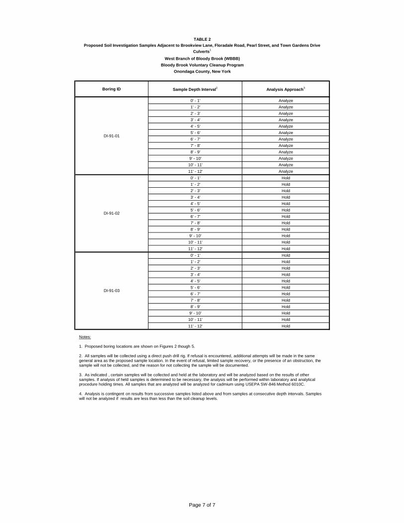
TABLE 2
West Branch of Bloody Brook (WBBB)Bloody Brook Voluntary Cleanup Program
Onondaga County, New York
Boring ID Sample Depth Interval2 Analysis Approach3
Proposed Soil Investigation Samples Adjacent to Brookview Lane, Floradale Road, Pearl Street, and Town Gardens Drive Culverts1
0' - 1' Analyze1' - 2' Analyze2' - 3' Analyze3' - 4' Analyze4' - 5' Analyze5' - 6' Analyze6' - 7' Analyze7' - 8' Analyze8' - 9' Analyze
9' - 10' Analyze10' - 11' Analyze11' - 12' Analyze
0' - 1' Hold1' - 2' Hold2' - 3' Hold3' - 4' Hold4' - 5' Hold5' - 6' Hold6' - 7' Hold7' - 8' Hold8' - 9' Hold
9' - 10' Hold10' - 11' Hold11' - 12' Hold
0' - 1' Hold1' - 2' Hold2' - 3' Hold3' - 4' Hold4' - 5' Hold5' - 6' Hold6' - 7' Hold7' - 8' Hold8' - 9' Hold
9' - 10' Hold10' - 11' Hold11' - 12' Hold
DI-91-01
DI-91-02
DI-91-03
Notes:
1. Proposed boring locations are shown on Figures 2 though 5.
2. All samples will be collected using a direct push drill rig. If refusal is encountered, additional attempts will be made in the same general area as the proposed sample location. In the event of refusal, limited sample recovery, or the presence of an obstruction, the sample will not be collected, and the reason for not collecting the sample will be documented.
3. As indicated , certain samples will be collected and held at the laboratory and will be analyzed based on the results of other samples. If analysis of held samples is determined to be necessary, the analysis will be performed within laboratory and analytical procedure holding times. All samples that are analyzed will be analyzed for cadmium using USEPA SW-846 Method 6010C.
4. Analysis is contingent on results from successive samples listed above and from samples at consecutive depth intervals. Sampleswill not be analyzed if results are less than less than the soil cleanup levels.
Page 7 of 7

FIGURES


APPENDIX A

Prepared for: Prepared by: Lockheed Martin Corporation AECOM Latham, NY
60303286 March 2014
Environment
Community Air Monitoring Work Plan West Branch of Bloody Brook Bloody Brook Voluntary Cleanup Program Onondaga County, New York March 2014
Prepared for: Lockheed Martin Corporation Syracuse, New York
Prepared by: AECOM Technical Services Northeast, Inc. 40 British American Boulevard Latham, New York 12110

AECOM Community Air Monitoring Plan i
60303286 March 2014
Contents
1.0 Introduction .......................................................................................................................... 1
2.0 Community Air Monitoring Plan ........................................................................................ 2
2.1 CAMP Implementation during RA Activities ........................................................................... 2
2.2 CAMP Particulate Action Levels ............................................................................................ 2
2.3 Data Recording ....................................................................................................................... 3
2.4 Noise ....................................................................................................................................... 3
AECOM Community Air Monitoring Plan 1
60303286 March 2014
1.0 Introduction
This Community Air Monitoring Plan (CAMP) has been prepared to summarize the air monitoring procedures that will be implemented during field activities associated with the Remedial Action (RA) at the West Branch of Bloody Brook (WBBB) site. For the purposes of this CAMP, the WBBB site, as shown on the Design Drawings included as Attachment A of the March 2014 Construction Work Plan, is defined as that portion of the WBBB and the surrounding area commencing on the southern boundary of the New York State Thruway (Thruway) and ending at Onondaga Lake Parkway.1 The RA activities are described in the March 2014 Construction Work Plan. The RA activities will be performed pursuant to a Voluntary Cleanup Agreement (VCA) between Lockheed Martin and New York Department of Environmental Conservation (NYSDEC) (Index #: D7-0001-01-09, effective July 20, 2002).
This CAMP has been developed consistent with NYSDEC’s guidance entitled DER-10 Technical Guidance for Site Investigation and Remediation (NYSDEC, May 2010) (DER-10) and the New York State Department of Health Generic Community Air Monitoring Plan (NYSDOH Generic CAMP) included as Attachment 1A of DER-10. The remedial investigation at the WBBB site has identified cadmium (a heavy metal) as a contaminant of concern. Because a heavy metal was identified as the contaminant of concern, DER-10 requires that the CAMP include real-time monitoring for particulates (i.e., dust) at the downwind perimeter of a work area during ground intrusive activities. The intent of this CAMP is to provide a measure of protection for the downwind community (i.e., off-site receptors including residences and businesses) from potential airborne contaminant releases as a direct result of the RA activities. Additionally, the data generated to maintain compliance with the CAMP will confirm that RA activities will not spread contamination off-site through the air. The CAMP is not intended for use in establishing action levels for worker respiratory protection. Instrument readings obtained as part of the CAMP will be recorded and available for NYSDEC and New York State Department of Health (NYSDOH) personnel to review.
Real-time air monitoring for particulates (i.e., dust) will be conducted continuously for all ground intrusive activities (e.g., soil excavation, backfilling, etc.). The remedial investigation at the WBBB site did not identify volatile organic compounds (VOCs) as a contaminant of concern. Therefore, community air monitoring for VOCs is not anticipated at this time.
1 The term “site” in the VCA is defined as: a portion of the banks, surface waters and sediments of the West and Middle Branches of Bloody Brook located in the Town of Salina, which commences downstream of Interstate 90, the New York State Thruway, and which extends generally southward past the confluence of the West Branch and the Middle Branch of Bloody Brook, and ends on the upstream side of Onondaga Lake Parkway. After examining data developed during remedial investigation work in the Middle Branch, NYSDEC determined that no further action was required for that branch of Bloody Brook. For this reason, the “WBBB site” in this CAMP relates only to those areas within the VCA site where the remedial program continues to be implemented and remedial action is being performed.

AECOM Community Air Monitoring Plan 2
60303286 March 2014
2.0 Community Air Monitoring Plan
2.1 CAMP Implementation during RA Activities
CAMP monitoring locations will initially be located at the boundary of the work area. The CAMP monitoring will be performed using a real-time aerosol monitors such as a Thermo MIE pDR-4000 DataRam (data-RAM) or equivalent equipment capable of monitoring airborne dust consisting of particulate matter measuring less than 10 micrometers in size (PM-10) and capable of integrating over a period of 15 minutes (or less) for comparison to the airborne particulate action level listed is Section 2.2. The equipment will be equipped with an audible and visual alarm to indicate that a response level has been exceeded. In addition, an electronic alarm will be sent to the site engineer and superintendent’s mobile phone or similar electronic device. Location-specific CAMP procedures will be developed daily as weather conditions and RA work areas and activities change. The location-specific procedures will be based on factors such as wind direction and the proximity of potential receptors to each RA work area.
2.2 CAMP Particulate Action Levels
The following action levels for particulates are in accordance with the NYSDOH Generic CAMP:
Action Level Response
>0.1 mg/m3 Above the background for the 15 minute average or if airborne dust is observed leaving the work area
Employ dust suppression techniques
0.1 to 0.15 mg/m3 Work may continue with dust suppressions techniques provided downwind PM-10 particulate levels do not exceed 0.15 mg/m3
above background for the 15-minute average and airborne dust is not observed leaving the work area
>0.15 mg/m3 Cease operations. Contact PM, Director of Health, and Safety or designee immediately.
Best Management Practices will be implemented to control dust at the WBBB site. In the event any of the conditions presented above, occur additional measures will be implemented. Work stoppage and restart activities will follow the details provided in the NYSDOH Generic CAMP.
Depending on particulate readings taken at the exclusion zone boundary, CAMP monitoring may be extended beyond the perimeter of the exclusion zone to meet the specifications identified in the NYSDOH Generic CAMP.

AECOM Community Air Monitoring Plan 3
60303286 March 2014
2.3 Data Recording
Air monitoring readings will be measured and recorded both electronically via the instrument data logger and manually using a logbook, as appropriate. The readings will be exported from the monitoring equipment and placed in the project records. Additionally, instantaneous readings used for decision purposes, if any, will be recorded on the daily notes and/or logs and placed in the project records. Steps taken to control dusts (e.g., watering) and any additional measures taken to address any exceedances will be documented. The air monitoring data and manual recordings will be made available to the NYSDEC and NYSDOH personnel upon request.
2.4 Noise
Work activity scheduling will comply with local noise ordinances, which specify permitted noises as including construction work, between the hours of 7:00 am and 9:00 pm. Unavoidable work outside of these permitted hours shall not emit noise levels above 88 decibels when measured 50 feet from the work (e.g., by-pass pumping operation). No unnecessary construction shall be permitted on weekends unless local proper police, fire, and safety groups are notified.
APPENDIX B

Traffic Maintenance and Safety Plan Soil Sampling Around Culverts Bloody Brook Voluntary Cleanup Program Onondaga County, New York October 2014
Prepared for: Lockheed Martin Corporation Syracuse, New York
Prepared by: AECOM Technical Services Northeast, Inc. 40 British American Boulevard Latham, New York 12110

AECOM Traffic Maintenance and Safety Plan
i
Contents
1.0 Introduction .................................................................................................................. 1
2.0 Traffic Control Procedures .......................................................................................... 1
2.1 Lane Closure on Two-Lane Road Using Traffic Control Person ........................................1
List of Figures Figure 1 – Lane Closure on Two-Lane Road

1
1.0 Introduction
This document is the Traffic Maintenance and Safety Plan (TMSP) for work to be completed in parking lots and roadways in the vicinity of the culverts that transfer the West Branch of Bloody Brook under Brookview Lane, Floradale Road, Pearl Street, and Town Gardens Drive. Specifically, soil samples will be collected from these roadways to define the proper management of the soils that will be disturbed to allow for replacement of these culverts.
Because Lockheed Martin Corporation is anticipating traffic flow restrictions in the Town of Salina due to the soil boring activities, a Lockheed Martin Corporation representative will contact the appropriate police department and fire department to notify them of any traffic flow restrictions.
The remainder of this TMSP describes the traffic control measures that will be implemented to facilitate the advancement of the soil borings.
2.0 Traffic Control Procedures
Lockheed Martin Corporation is anticipating some traffic flow restriction during the soil boring activities on Brookview Lane, Floradale Road, and Town Gardens Drive, which is a private road. The locations of planned activities within these roadways are shown on Figures 2, 3, and 5 of the Work Plan. The Manual on Uniform Traffic Control Devices for Streets and Highways 2009 Edition (MUTCD) was referenced to compile the procedures to be used for temporary traffic control during the soil boring activities. As described in the remainder of this section, the temporary traffic control plan that will be used to complete the soil boring activities are for lane closure on a two-lane road using a traffic control person.
The locations to be sampled in the vicinity of the Pearl Street culvert, shown on Figure 4, are within a private parking lot. For these samples, the area of the parking lot needed for sampling will be blocked off with cones during sampling activities.
2.1 Lane Closure on Two-Lane Road Using Traffic Control Person During the soil boring activities on Brookview Lane, Floradale Road, and Town Gardens Drive, a lane of the roadway where the soil borings will be collected will need to be closed during work hours to allow for workers and equipment to maneuver safely. The traffic will be open to normal traffic flow at the end of each work day. In accordance with the MUTCD, Typical Application 10 will be used as the basis for a temporary traffic control plan for a lane closure on a two –lane road using a traffic control person. A typical temporary traffic control plan for a lane closure on a two –lane road using a traffic control person is illustrated on Figure 1.

2
Figures