CulturalWiki: A Semantic Map-Based Wiki for ... · CulturalWiki: A Semantic Map-Based Wiki for...
17
CulturalWiki: A Semantic Map-Based Wiki for Interdisciplinary Collaboration Stefano Valtolina 1 , Barbara Rita Barricelli 2 , Michele Sciarabba 1 1 Department of Computer Science, Università degli Studi di Milano, Via Comelico 39/41, 20135 Milan, Italy {valtolin, sciarabba} @ di.unimi.it 2 Sociotechnical Centre for Internationalisation and User Experience, University of West London, St Mary's Road, Ealing London W5 5RF – UK [email protected] Abstract. The use of digital maps capitalizes on the long tradition of using paper maps as mean of communication and learning among people. More than ever, maps are becoming one of the most used metaphors to present concepts and knowledge. This paper presents a wiki infrastructure for map-based information systems’ design that, through an ontology, defines a semantic model able to minimize the problems in communication across interdisciplinary communities by putting together cultural information from different data sources. Using map-oriented solution, the wiki is aimed at enabling intercultural collaboration and learning among all the stakeholders involved in cultural heritage projects. A living lab based on the use of the CulturalWiki framework is described and the results of evaluations are presented. Keywords: Wiki; maps; collaboration; interdisciplinary projects; learning; education; semantics; ontologies. 1 Introduction Map-based information systems are becoming increasingly popular solutions for handling, disseminating, teaching and learning cultural heritage (CH) concepts [1][2][3][4]. By map-based information system, we mean a system designed to enable the access to and management of information through the use of virtual environments e.g. geographic maps, building plans, planimetries, 360-degree panoramic images, and spaces in virtual reality. In CH context, the primary function of these systems is to offer map-based solutions for accessing cultural assets by means of services able to disseminate tangible or intangible knowledge. By tangible assets, we mean information entities related to specific cultural objects or points of interest represented through different multimedia supports (texts, videos, photos, and audio) and located in specific places. Instead, intangible assets denote sets of thematic, historic, geographic, artistic or anthropologic characteristics, practices, as well as knowledge and skills that identify Interaction Design and Architecture(s) Journal - IxD&A, N. 18, 2013, pp. 23-39
Transcript of CulturalWiki: A Semantic Map-Based Wiki for ... · CulturalWiki: A Semantic Map-Based Wiki for...

CulturalWiki: A Semantic Map-Based Wiki for Interdisciplinary Collaboration
Stefano Valtolina1, Barbara Rita Barricelli2, Michele Sciarabba1
1 Department of Computer Science, Università degli Studi di Milano, Via Comelico 39/41,
20135 Milan, Italy {valtolin, sciarabba} @ di.unimi.it
2 Sociotechnical Centre for Internationalisation and User Experience, University of West London, St Mary's Road, Ealing
London W5 5RF – UK [email protected]
Abstract. The use of digital maps capitalizes on the long tradition of using paper maps as mean of communication and learning among people. More than ever, maps are becoming one of the most used metaphors to present concepts and knowledge. This paper presents a wiki infrastructure for map-based information systems’ design that, through an ontology, defines a semantic model able to minimize the problems in communication across interdisciplinary communities by putting together cultural information from different data sources. Using map-oriented solution, the wiki is aimed at enabling intercultural collaboration and learning among all the stakeholders involved in cultural heritage projects. A living lab based on the use of the CulturalWiki framework is described and the results of evaluations are presented.
Keywords: Wiki; maps; collaboration; interdisciplinary projects; learning; education; semantics; ontologies.
1 Introduction
Map-based information systems are becoming increasingly popular solutions for handling, disseminating, teaching and learning cultural heritage (CH) concepts [1][2][3][4]. By map-based information system, we mean a system designed to enable the access to and management of information through the use of virtual environments e.g. geographic maps, building plans, planimetries, 360-degree panoramic images, and spaces in virtual reality.
In CH context, the primary function of these systems is to offer map-based solutions for accessing cultural assets by means of services able to disseminate tangible or intangible knowledge. By tangible assets, we mean information entities related to specific cultural objects or points of interest represented through different multimedia supports (texts, videos, photos, and audio) and located in specific places. Instead, intangible assets denote sets of thematic, historic, geographic, artistic or anthropologic characteristics, practices, as well as knowledge and skills that identify
Interaction Design and Architecture(s) Journal - IxD&A, N. 18, 2013, pp. 23-39

and define a group or civilization. Since important recent researches [5][6][7] have recognized the need to enlarge the level of community involvement in creating and enriching cultural knowledge, our idea is to offer tools to allow the organization of participants’ discussions about specific aspects of a given CH in order to offer new media for teaching and learning such content.
In an hypothetic scenario, by providing a map view of a territory, our system enables the user to visualise information about heritage of traditions, unwritten practices and the cultural characteristics of a territory, which together with the cultural heritage represented by tangible artifacts features a group or a community. These relationships are of paramount significance when cultural heritage is linked to the territory as an expression of the historical evolution and of the culture through the contributions of communities.
In these areas, the role of local communities of users, administrators and cultural operators is crucial to maintain and develop the distinctive cultural heritage of the territory itself.
Therefore, the idea is to provide domain-oriented habitable environments and tools for supporting collaboration between members of a specific community of interest (CoI) [8]. A CoI is a group of people (in our case geographers, geologists, archaeologists, experts in history or art, local government members, territorial and environmental advisors, students) with different background, expertise that come together for a shorter or longer time based on a common interest to solve a problem or learn about something they could not have done on their own. The communication mechanism in such environments is built around the map by means of the concept of boundary object [9]. A boundary object is an artifact used by members of a CoI in their practices but viewed and used differently by each member according to her/his background. Using the map the members of a CoI may share and manage cultural information. The map combined with such cultural information represents the boundary object using which each member of a CoI can collaborate for discussing, exchanging ideas around a specific cultural domain from different and interdisciplinary points of view.
As to learning and teaching, the use of maps for such purposes enables the dissemination of the information in a flexible way according to a specific context of study through the definition of knowledge that meets and shares the domain experts’ perspectives. This is because only the domain experts have the necessary experience and knowledge to highlight real and proper historical and anthropological meanings of cultural data under which prospective the information have to be disseminated and taught [10].
A map-based habitable environment, called CulturalWiki, allows to put together interdisciplinary and heterogeneous information coming from multiple data sources which provide data about tangible and/or intangible knowledge. Meeting this data integration issue needs strategies for accessing and delivering information by means of communication and learning channels able to draw on heterogeneous data sources in a uniform way. The search for solutions to interoperability of heterogeneous data sources has been characterized by several semantic difficulties that are unique in cultural domain [11][12][13].
In this context, ontologies have been used both for offering uniform ways for representing cultural knowledge base and for supporting the design of new and
Interaction Design and Architecture(s) Journal - IxD&A, N. 18, 2013, pp. 23-39

flexible communication forms able to explicit, aggregate and convey knowledge about tangible and intangible assets according to different perspectives. Specially, in this paper we refer to a form of communication and teaching media named narration able to put in relation tangible data according to specific cultural aspects in order to reconstruct different contexts, depending on the source, when known, or on the semantic spheres of reference and accessible through a map-based environment. Narrations are a tool used to represent a cultural content and to support the communication among experts around it. A narration system is meant to exploit a semantic net of concepts, with the aim to create or enhance knowledge and to disseminate cultural information to the large public. Moreover, this process of data and concept mining can also be very useful to build up the first step of a quick dissemination among scholars. Narrations permit in fact to summarize the results of scientific research in cultural heritage and to keep information concerning different fields of research constantly up-to-dated [14].
The novelty of this approach is related to the definition of a CulturalWiki framework able to support collaborative processes carried out by means of a user-controlled map navigation or through different semantic knowledge exploration strategies and applicable to different cultural contexts. In fact, to verify the validity of our framework we tested it in the context of different living labs. By way of example, in this paper, we describe a living lab that is referred to a mountain community in which intangible assets are related to arts and crafts of the valley, traditions and memories merchant of travellers who have crossed the valley over the centuries. In this lab, the knowledge model has been defined and integrated in the system with a set of narrations, created by domain experts, able to link intangible assets with data coming from multiple data sources, whereas the social requirement has been developed using different annotation strategies to support users and experts’ participation.
The structure of this paper is outlined in the following way. First, we present an overview of collaborative strategies in map-based wiki systems with a focus on solutions in cultural domains and on map capabilities in supporting collaboration. Then, semantic explorations of tangible and intangible CH are presented and discussed for designing digital media in supporting knowledge communication of cultural data. This section also describes our ontological approach for sharing multiple cultural data sources and for offering a service-oriented solution for knowledge retrieval based on maps. In the next sections, the implementation case of the CulturalWiki framework is illustrated and the results of its evaluations are presented.
2 State of the Art: From Paper Maps to Map-Based Wikis
Maps are one of the more ancient tools developed by humans for knowledge organization and visualization. They are “visual depiction of a subject, highlighting relationships characterizing the subject through a space based representation.” [15]. Used as tools for geographical information, maps reproduce terrestrial surface areas in an abstract way (only the most important characteristics – considered relevant for a
Interaction Design and Architecture(s) Journal - IxD&A, N. 18, 2013, pp. 23-39

particular use – are shown) and using symbols – e.g., dots for cities, lines for rivers. Also additional types of information are representable on maps, like distances, coordinates, elevation, and administrative boundaries. However, maps are not just tools used in geographical context; they can be used to represent knowledge about a certain topic by visualizing entities and relations among them using a geographical metaphor. For example, maps can be used to represent historical data, not just as geographical areas affected by historical events but also as events that took place in time.
According to Kuhn [16], “space is not just any domain of experience, but the most important one and as such uniquely qualified as a metaphor source”.
In the digital age, the evolution of maps from being printed on paper to being represented on electronic devices, changes deeply their use and nature. Any modification to be made on a paper map requires its complete redraw. On the contrary, the visualization of digital maps depends on data stored in databases and is therefore highly dynamic. Another important contribution given by the digitalization of maps is their interactivity: different people can work on a map in a collaborative way, acting directly on the data.
In this way, maps become new media of knowledge creation, accumulation, distribution, learning and sharing is fostered. The maps evolve becoming digital interactive, pro-active tools, which content changes in time. Maps evolve therefore from simple representation of a shared knowledge base to an interaction tool by which the members of a community can interact among them and on the map.
In the last years, digital map has become a very wide used tool in CH field. In this context the so-called Locative Media emerge as technologies and processes that promise to reconfigure our understandings and experiences of space and culture [17]. They support people to collaborate in common activities related to real or virtual spaces and enable the creation and grow of social communities. To this aim, digital maps are used to support communication and sharing of knowledge and are used as boundary objects for cooperative activities. Two main categories of locative media projects have been identified in [18]: phenomenological and annotative. In phenomenological locative media projects the actions of people are traced and from their behavior information about the environment are derived. On the other hand, annotative locative media projects enables the users to change the world in which they live by adding data to it and are made possible by the use of Web 2.0 technologies that support cultures of participation [5]. Annotation tools allow users in (1) creating and managing a shared knowledge base, and (2) using digital maps as locative media to support knowledge sharing and access [19][20].
One typical application of digital maps in Locative Media is the Map-Based Wiki. Map-Based wikis are information systems able to join the collaborative nature of wikis with the potential of digital interactive maps. Several experiences of locative media projects in which users are enabled to actively contribute give indications on the use of annotation tools to support knowledge gathering and management.
WikiMapia [1] combines Google Maps with a wiki system and permits to create and maintain a free, multilingual, editable interactive map, which allows actors to add information, notes and photos related to points of interest. WikiMapia could also be accessed through the use of mobile devices via another system called WikiPlaces [2].
Interaction Design and Architecture(s) Journal - IxD&A, N. 18, 2013, pp. 23-39

Hide&SEEK project [3] faces the challenge of exchanging cultural knowledge through the creation of a collaborative street game. Users can publish annotations on a map through the use of any device with wireless networking capabilities.
Analogously, Radio Aporee [4] is a Web application that supports the collaborative creation and exploration of public soundscapes. Actors can upload and manage audio clips associated with locations around the world.
2.1 CulturalWiki contributions
None of the above mentioned locative media projects take into account the diversity of roles that the stakeholders might have in a specific application case. Our approach enables the active participation of all the stakeholders involved in a project, both domain experts and end users, i.e. students. Their role in the project is to adapt and personalize the systems interfaces in order to offer them an interaction based on notations that they know and use in their everyday activities. In the projects presented above, there is no chance to use different maps. This constitutes a limitation that our approach overcomes: our framework is in fact independent from the maps that are used to represent the CH information and hence is it possible to represent the same information on different maps and to highlight different aspects of the same context.
The common feature that our framework has with the other locative media projects presented here is the use of annotation tools to empower the users and to involve them in the information creation process. Our framework, however, makes a step forward in this direction: it introduces also a narration tool.
In this context, the narration concept enables to highlight aspects of intangible heritage through the establishment of semantic relations among cultural assets spread on the territory. Through a narration, an expert in a specific area is able to describe a cultural path according to his/her perspective and point of view (as in wiki systems), but also according to its time-space dimensions and its anthropological, economic, social, religious or emotional meaning that have characterized its origin and development. Furthermore, a narration is able to highlight aspects of intangible assets, from different information sources scattered across the territory, which are placed in relation to each other according to specific cultural aspects in order to reconstruct different contexts, depending on the source, when known, or on the semantic spheres of reference. Thus, this approach with intangible cultural heritage is beyond the concept of isolation, common in the current mode of access to cultural assets.
Therefore, in the CulturalWiki, the narrations represent innovative media that allow to access, transmit, share and enrich knowledge bases relating to a specific cultural heritage by laying a network of semantic associations are able to build a cultural complex panorama.
Interaction Design and Architecture(s) Journal - IxD&A, N. 18, 2013, pp. 23-39

3 Interdisciplinary Collaboration in Cultural Heritage: Map-based Wikis
Cultural Heritage is one of the fields in which technology is making great strides. It is no longer adopted just for document archiving but for the implementation of powerful software tools in support of advanced research, of knowledge dissemination and for heritage promotion and preservation. To successfully perform these activities, it is needed to exploit both the knowledge held by domain experts and the one possessed by the other stakeholders. The collaboration among all of them is fundamental for the retrieval of information related to tangible and intangible assets in CH.
3.1 Collaboration in Cultural Heritage
The adoption of technology in this context strongly supports the evolution of users’ role, especially students, from being passive consumers to active producer of information and knowledge, i.e. produsers [21][22]. This paradigm shift stands at the base of the successful development of collaborative systems. However, the interdisciplinary nature of this collaboration brings some challenges, related to communication, one of the main key aspects in a collaborative activity, mostly if it is computer-mediated. The different cultures, skills and working habits possessed by the stakeholders led to communication gaps that tend to hinder the communication process.
To address these challenges, our contribution is the creation of a map-based framework, CulturalWiki, for knowledge management aimed at (1) offering a set of services for the retrieval and access to CH on different information sources, and (2) supporting the communication among all the stakeholders allowing them to share their knowledge and experiences using the map as a boundary object able to support the collaboration among member of a CoI.
4 Semantic Exploration of Tangible and Intangible Cultural Heritage
Nowadays, map-based information systems have to face the problem of facilitating the exploration and analysis of vast amount of geographic and cultural data that they make available. The challenge is twofold: (1) to efficiently manage and integrate different sets of sources of cultural data so that these data may be visualized and queried in a map-based environment, and (2) to offer a semantic representation of cultural assets and their relationships in order to support intuitive and useful researches. Meeting these challenges demands a knowledge base model that allows to combine tangible cultural assets with intangible heritage, in order to offer new reading keys of the tangible objects according to their semantics.
In our approach, we adopt a solution for reunifying CH tangible assets dispersed in museums, cultural institutions and the territory at large through the use of innovative digital media: New digital communication media which allow creation, access and
Interaction Design and Architecture(s) Journal - IxD&A, N. 18, 2013, pp. 23-39
enrichment of the intangible CH through the participation of experts and end users. The idea is to define a map-based collaborative framework in which to use intangible CH as new concept of fruition for unifying spatially, temporally and thematically dispersed assets and to provide new and flexible forms of communication.
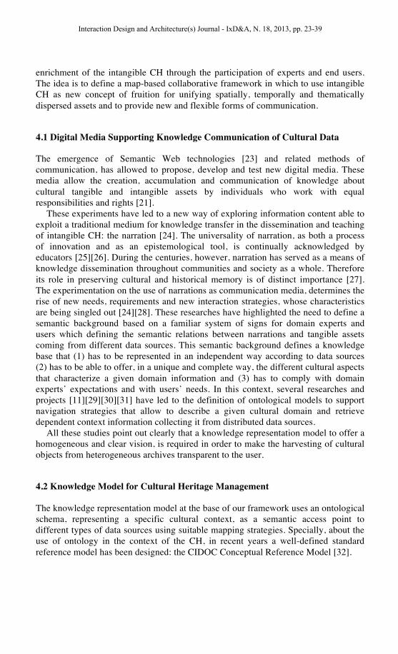
4.1 Digital Media Supporting Knowledge Communication of Cultural Data
The emergence of Semantic Web technologies [23] and related methods of communication, has allowed to propose, develop and test new digital media. These media allow the creation, accumulation and communication of knowledge about cultural tangible and intangible assets by individuals who work with equal responsibilities and rights [21].
These experiments have led to a new way of exploring information content able to exploit a traditional medium for knowledge transfer in the dissemination and teaching of intangible CH: the narration [24]. The universality of narration, as both a process of innovation and as an epistemological tool, is continually acknowledged by educators [25][26]. During the centuries, however, narration has served as a means of knowledge dissemination throughout communities and society as a whole. Therefore its role in preserving cultural and historical memory is of distinct importance [27]. The experimentation on the use of narrations as communication media, determines the rise of new needs, requirements and new interaction strategies, whose characteristics are being singled out [24][28]. These researches have highlighted the need to define a semantic background based on a familiar system of signs for domain experts and users which defining the semantic relations between narrations and tangible assets coming from different data sources. This semantic background defines a knowledge base that (1) has to be represented in an independent way according to data sources (2) has to be able to offer, in a unique and complete way, the different cultural aspects that characterize a given domain information and (3) has to comply with domain experts’ expectations and with users’ needs. In this context, several researches and projects [11][29][30][31] have led to the definition of ontological models to support navigation strategies that allow to describe a given cultural domain and retrieve dependent context information collecting it from distributed data sources.
All these studies point out clearly that a knowledge representation model to offer a homogeneous and clear vision, is required in order to make the harvesting of cultural objects from heterogeneous archives transparent to the user.
4.2 Knowledge Model for Cultural Heritage Management
The knowledge representation model at the base of our framework uses an ontological schema, representing a specific cultural context, as a semantic access point to different types of data sources using suitable mapping strategies. Specially, about the use of ontology in the context of the CH, in recent years a well-defined standard reference model has been designed: the CIDOC Conceptual Reference Model [32].
Interaction Design and Architecture(s) Journal - IxD&A, N. 18, 2013, pp. 23-39

The CIDOC-CRM ontology is intended to promote a shared understanding of CH information by providing a common and extensible semantic framework that any CH information can be mapped to.
This ontology is explored through the use of semantic queries that allow to retrieve tangible assets through proper classes and properties. Another strategy for exploring the ontology and related data sources is to use the narration concept.
Narration allows users to define exploration strategies by highlighting semantic links. Moreover, through a narration, an expert is able to link the description of an intangible cultural asset with a set of semantic concepts representing her/his perspective and point of view according to time-space dimensions and anthropological, economic, social, religious or emotional characteristics of the narration itself. Through the definition of these dimensions and characteristics, a narration is able to put in relation an intangible asset with tangible cultural objects retrievable from different data sources scattered across the territory.
A second goal of our proposal is based on the assumption that the evolution and enrichment of a cultural knowledge base is also based on the end users’ participation. Users through the use of locative media are able to participate in enriching the knowledge base as knower of particular cultural aspects of domain of interest.
In our case, representatives of different involved communities (museums curators, researchers, geographers) or simple users (students, tourists, citizens) may be able to share and exchange experiences and information through the use of wiki system based on the use of annotations to create a base of shared and constantly evolving knowledge.
In this way, the annotation becomes a medium capable of providing the end users the opportunity to join a community or create their own communities where data and cultural knowledge may be related and shared and where the users can insert new contributions in the knowledge-based web system as is the case in traditional wiki systems [33].
Specially, we defined a semantic annotation strategy through which users can add notes, comments and impressions to any representation of a cultural object (both tangible than intangible) or a part of it, connecting them to the semantic of the domain in which these resources are placed.
Once the ontology and the mapping to the data sources are established, a set of Web services, invokable for accessing information in a homogeneous way, has been defined. The idea is to offer a set of Web services able to define a common interface for accessing cultural objects through semantic queries. Such queries can then be customized according to specific parameters characterizing each service. For example, it is possible to retrieve cultural objects, filtering them according to specific categories (only cultural buildings, churches, geological points of interest) or to specific multimedia supports (pictures, only audio/video information, or combination of them) or to particular user needs (only high quality images, audio files in the given standard) or even on the basis of specific access privileges.
In order to highlight the semantic dimensions associated with our framework, it has been extended with services dedicated to the retrieval of annotations or narrations. The service devoted to retrieve narrations, recovers both the text of the narration itself and the set of cultural objects belonging to its semantic context.
Interaction Design and Architecture(s) Journal - IxD&A, N. 18, 2013, pp. 23-39

4.3 Semantic Framework for Map-Based Information Systems
Through the use of services for retrieving cultural assets, narrations and annotations our system allows to overlay geo-referenced information on maps, building plans or other visualizations of environments such as 360-degree panoramic images or spaces in virtual reality. These services are able to interface with archives of maps and a set of public services made available by Google and/or Open Street map and/or local maps for retrieving geographical and spatial maps. The integration between cultural data, narrations and annotations and map resources offers different visual interaction strategies. The general process of interaction is performed by means of user-controlled map navigations or through different strategies for knowledge explorations.
Map-based navigation supports multimedia information sharing by means of icon placements on the map. Interacting with icons, it is possible to provide rich descriptions about a point of interest or narrations related to it by querying proper Web-services. Exploring information or narrations about a point of interest, a user can undertake a journey for understanding in a better way some aspects of the CH under examination.
To make this point clear, let us give an example. Through a geographic map, a user selects an icon of a specific city and the system retrieves a description about it. The user reads that a famous poet lived in this city, and a link brings her/him to a narration about the poet. In this narration, s/he reads that, in another city, there is a museum dedicated to this poet, and from the narration s/he accesses the information about the museum.
In visualizing this information, the user expects to see a geographic contextualization of this museum on the map. And so happens, a map-animation is triggered in order to jump in this new city and to focus on the location of the museum. In this case the maps become a powerful tool to keep users informed about the geographic context of the visualized data. Moreover the user in every moment can easily switch from an interaction path to the other one.
5 Framework Implementation Case
In this section we introduce a case where we applied the described framework for the fruition and collaborative increasing of the CH of a valley in the Alps.
Interaction Design and Architecture(s) Journal - IxD&A, N. 18, 2013, pp. 23-39

Fig. 1. The system using a geographical map of Valchiavenna valley, on which some points of interest are visualized.
This project, named The Valchiavenna Project, aims at the conservation and valorization of the historical, artistic and naturalistic heritage of Valchiavenna valley, in the Italian Alps. One of the goals of the project was the development of a Web portal for the valorization of tangible and intangible cultural assets. Many different partners were involved in the project: the local community, geographers, geologists and the computer science department. This interdisciplinary collaboration is supported by the Web portal (Fig. 1) that offers three user profiles, which are allowed to perform different operations: Unregistered visitors, registered users and Experts.
The knowledge base is structured around three main elements: points of interest
and touristic paths and thematic narrations that are collections of points of interests. The content of the knowledge base is kept disjoined from the maps used in the system. It is displayed on a layer over the maps and therefore, it is possible to easily change the underlying maps system. In the Valchiavenna Portal, we use Google Maps, OpenStreetMap and personalized maps based on a Web GIS (GeoServer).
Besides switching the underlying map, users can also choose what they want to see in the layer representing content from the knowledge base.
They can view points of interest, choosing from different categories or choosing points related with a particular thematic narration, touristic paths and annotations created by other users. Registered users can also add new annotations on the map and the experts can add new points of interest.
The layer and maps visualization is managed with AJAX techniques and SVG.
Interaction Design and Architecture(s) Journal - IxD&A, N. 18, 2013, pp. 23-39
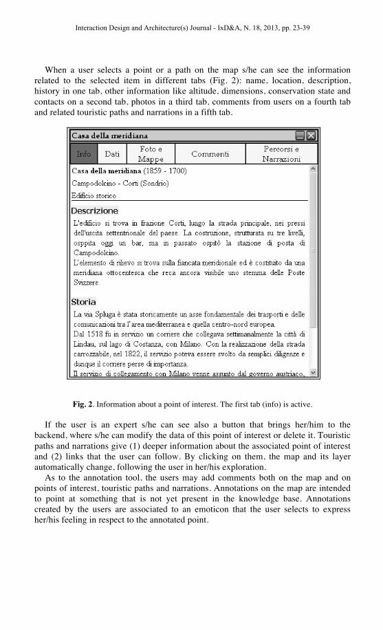
When a user selects a point or a path on the map s/he can see the information related to the selected item in different tabs (Fig. 2): name, location, description, history in one tab, other information like altitude, dimensions, conservation state and contacts on a second tab, photos in a third tab, comments from users on a fourth tab and related touristic paths and narrations in a fifth tab.
Fig. 2. Information about a point of interest. The first tab (info) is active.
If the user is an expert s/he can see also a button that brings her/him to the backend, where s/he can modify the data of this point of interest or delete it. Touristic paths and narrations give (1) deeper information about the associated point of interest and (2) links that the user can follow. By clicking on them, the map and its layer automatically change, following the user in her/his exploration.
As to the annotation tool, the users may add comments both on the map and on points of interest, touristic paths and narrations. Annotations on the map are intended to point at something that is not yet present in the knowledge base. Annotations created by the users are associated to an emoticon that the user selects to express her/his feeling in respect to the annotated point.
Interaction Design and Architecture(s) Journal - IxD&A, N. 18, 2013, pp. 23-39

5.1 CulturalWiki in practice
This section describes a typical scenario of use that shows the potentials of the CulturalWiki system when applied in the Valchiavenna project.
A tourist that has recently visited the Valchiavenna valley wants to contribute to the shared knowledge base writing about an interesting rural complex, probably a so-called “Alpeggio” (alpine pasture land) , he encountered during his trekking trips. The tourist used the wiki before his visit and could not find any information about that complex at that time, so he decides to add an annotation on the map.
Some days later an local resident of the valley decides to reply to the tourist’s annotation, explaining that the rural complex is actually called “Alpeggio of Borghetto”, and gives information about how this site is used. She also writes that, very close to this site there must be some archaeological evidences of a human settlement (Fig. 3).
Fig. 3. Annotations from the users (up) and the interface to reply to an annotation(down).
A domain expert (a local expert of the Valchiavenna culture) sees the annotations and realizes that the “Alpeggio” is actually a point of interest that should be added, and he does so using the interface provided for entitled experts (Fig. 4). He also realizes, since he knows the existence of the archaeological site, that some help from an archaeologist would be useful. Therefore, he asks for help to the archaeologist involved in the project team.
The archaeologist – as she is an entitled expert too – can edit the point of interest added by the local domain expert, by adding the required further information about the importance of the site from an archaeological point of view.
Interaction Design and Architecture(s) Journal - IxD&A, N. 18, 2013, pp. 23-39

Fig. 4. Art of the interface that entitled experts use in order to insert or edit a point of interest.
Now that the new point of interest is on the map available to all the wiki users, it can be annotated (cfr. Fig.2, the fourth tab contains annotations from the users).
On the basis of the information included in the point of interest by the experts, this point is now linked within any narration that has a content related to its context.
For instance, the point is linked in the narration (Fig. 5) that talks about the “Alpeggi” structures, in the tab dedicated to the points of interested that are related to the narration itself. In the same way also the reverse link is created (from the point of interested a link to the narration is added, cfr. Fig.2, the fifth tab).
Interaction Design and Architecture(s) Journal - IxD&A, N. 18, 2013, pp. 23-39

Fig. 5. The "related points" tab of the narration “Alpeggio”.
Moreover, given that the point of interested is located along a touristic path, it is also added to this path description and becomes part of the suggested paths in the wiki (Fig. 6).
Fig. 6. The "related points" tab of the touristic path. On the background: the map with the path.
6 Contributions and future development
To evaluate the contributions of CulturalWiki in the real practice in cultural heritage we observed its use (with user tests) and we interviewed the users to investigate about their satisfaction and expectations about the use of CulturalWiki in their daily practice.
6.1 User Test
The user test conducted on the Valchiavenna Cultural Portal followed the within-groups modality with one observer. Four users have been involved in the test. An initial questionnaire has been submitted to the users to identify their profiles in terms of mother tongue, age, and education.
During the test, they were all required to perform a set of four tasks, and the think-aloud approach was used. For each task performed by the user, the observer took note of duration of the execution (if the user does not complete a task in the maximum time allowed, the observer has to ask the user to pass to the next task), Number of clicks needed to complete the task, and List of errors committed by the user. All the tasks have been completed successfully, respecting the estimated execution time and with a reasonable number of clicks. After the test, the users were required to fill in a questionnaire aimed at investigating their satisfaction in using the system. The results obtained by the execution of the tasks and by the answers to the final questionnaire proved that the system well answers to tourists’ needs..
Interaction Design and Architecture(s) Journal - IxD&A, N. 18, 2013, pp. 23-39

For example, user 3 claims that “… this tool would help a better exploitation of the CH of a territory through an active participation of citizens and tourists” or user 4 says “… I think CulturalWiki is a useful system because it enables users in using a map for discovering cultural information and it provides to them the possibility to share comments, opinions,…” or finally user 1 claims: “narration is a very attractive solution for delivering historic, cultural aspects of a territory and, the connections between a narration ad real places represent a good way for contextualizing these aspects on the territory”.
Nevertheless Culturalwiki needs some improvements in order to offer very effective and satisfying solution. For example user 1 claims that “I expected to have a functionality for helping me to discover most attractive places according to the feedback of other members of the community but this functionality is missing”, moreover all users criticized the missing of a multilingual support in the system.
6.2 Plans for the future
There are a number of reasons why an ontology-based approach has been adopted for the CulturalWiki system. The primary one is to permit the sharing of concepts among people and this means that the participants will bring in the community different cultures. Furthermore, CulturalWiki involves people with very different backgrounds, expertise and domain knowledge. In such a situation, effective communication and shared understanding can be difficult to achieve. To face this, our solution seeks to reduce conceptual and terminological misunderstandings by identifying and properly defining a set of concepts (and their relations) relevant to a specific CH. The result is a non-ambiguous and consistent vocabulary for identifying the relevant concepts, and a framework, based on the use of maps, on which diverse cultural aspects and members' community perspectives can be mapped.
Starting from these points, further improvements, which are currently under development , concern: • Better representation of user profiles and competencies as a backbone for
cultivating communities. The idea is to use the user profiles as hubs for creating and fostering thematic CoIs according to specific competences and skills;
• A core module for multilingual and multicultural functionality; • Support for personalized interaction with adaptive user applications. The idea is to
customize the interactive environment according to the user profile; • Support for the implementation of a recommendation engine. In this case,
tangible, intangible heritage assets and narrations will be provided to the user according to metadata associated to contents, user profiles and expectations, user feedbacks of members of the community.
These improvements are addressed to design a CulturalWiki system able to provide more and more effective CH valorization and exploitation, with particular attention to those aspects related with sharing of digital resources and practice among potential members of a CoI of a specific territory – namely citizens, local cultural entities, visitors, domain experts (experts in history, art, geography and so on) – involved as content producers and not only consumers.
Interaction Design and Architecture(s) Journal - IxD&A, N. 18, 2013, pp. 23-39

7 Conclusion
The implemented case of the CulturalWiki framework that we described above is an example of its potentials in terms of knowledge organization and representation through a map-based information system. The evaluations carried out for the Valchiavenna case pointed out that the implemented system well answers the needs of the users and that the collaboration in intercultural context is successfully supported.
Future developments will concern other cases of study for evaluating the CulturalWiki framework in different domain contexts and living labs. For example a under design system is related to the development a solution able to offer a virtual visit of some Etruscan museums, where the navigation environment is not a geographic map but a set of 360 degrees panoramic images.
Acknowledgments. The work of Barbara Rita Barricelli and Michele Sciarabba is supported by Regione Lombardia in the frame of the programme “Dote Ricerca Applicata - Regione Lombardia - Ob.2 Asse IV - FSE 2007-2013” on the projects “CulturalWiki: un’infrastruttura collaborativa per la gestione di percorsi culturali” and “Wicko: sistema per la gestione collaborativa di basi di conoscenza in comunità di interesse”.
References
1. Wikimapia, http://wikimapia.org/, Accessed 20 August 2012. 2. Wikiplaces, http://www.mifki.com/wikiplaces/, Accessed 20 August 2012. 3. Giles T., Marienek M., Willis K.S., Geelhaar J.: Hide&Seek: sharing cultural knowledge,
Proc. ACM MM 2007, pp. 481--484, ACM Press, (2007) 4. Radio aporee, http://aporee.org/maps/, Accessed 20 August 2012 5. Fischer G.: Cultures of participation and social computing: Rethinking and reinventing
learning and education, Proc. ICALT 2009, IEEE Computer Society, pp. 1--5, (2009) 6. Brown J.S., Duguid P.: The social life of information, Harvard Business School Press,
Boston, MA, USA, (2000) 7. Valtolina S., Barricelli B.R., Dittrich Y.: Participatory knowledge-management design: A
semiotic approach, J. Vis. Lang. Comput. 23(2), pp. 103—115, (2012) 8. Fischer, G., Communities of interest: learning through the interaction of multiple
knowledge systems, in: Proceedings of IRIS 2001, 2001, pp. 1–14. 9. Star S.L., Griesemer J.R.: Translations’ and Boundary Objects: Amateurs and
Professionals in Berkley’s Museum of Vertebrate Zoology 1907-39, Social Studies of Science, 19(3), pp. 387--420, (1989)
10. Fruchter, R., Townsend, A.: Multi-Cultural Dimensions and Multi-Modal Communication in Distributed Cross Disciplinary Teamwork. Int. J. Engng Ed. Vol. 19, No. 1, pp. 53--61, (2003)
11. Valtolina S.: Design of knowledge driven interfaces in cultural contexts, Int. J. Semantic Computing 2(4), pp. 525--553, (2008)
12. Floyd C., Ukena S.: On designing ontologies for knowledge sharing in communities of practice, Proc. CAiSE 2005 Workshops Vol. 2, pp. 559--569, FEUP Edições, (2005)
13. Aliaga D.G., Bertino E., Valtolina, S.: Decho-a framework for the digital exploration of cultural heritage objects, J. Comput. Cult. Herit. 3(3), pp. 1--26, ACM, (2011)
Interaction Design and Architecture(s) Journal - IxD&A, N. 18, 2013, pp. 23-39

14. Valtolina S., Mussio P., Mazzoleni P., Franzoni S., Bagnasco G., Geroli M., Ridi C., Media for Knowledge Creation and Dissemination: Semantic Model and Narrations for a New Accessibility to Cultural Heritage; Proceeding of the 6th Creativity & Cognition Conference (CC 2007), published by ACM, pp. 107-116, Washington DC, USA, June 13-15, 2007
15. Celentano A., Mussio P., Pittarello F.: Preface, PsychNology Journal 6(3), pp. 221--223, (2008)
16. Kuhn W.: Handling data spatially: Spatializating user interfaces, Proc. SDH’96, Taylor & Francis, pp. 877--893, (1996)
17. Galloway A., Ward M.: Locative Media As Socialising And Spatializing Practice: Learning From Archaeology, Leonardo electronic almanac, 14(3), (2006),
18. Tuters M., Varnelis K.: Beyond Locative Media. Networked Publics, (2006) http://networkedpublics.org/locative_media/beyond_locative_media, Accessed 20 August 2012.
19. Drew H.: Locative media, LEA 14(3-4), pp. 82--84, (2006) 20. Happel H.J.: Towards need-driven knowledge sharing in distributed teams, Proc. I-
KNOW’09, ACM Press, pp. 128--139, (2009) 21. Bruns A.: Blogs, Wikipedia, Second Life, and Beyond: From Production to Produsage,
Peter Lang, New York, NY, USA, (2008) 22. Fischer G.: End-user development and meta-design: Foundations for cultures of
participation, Proc. IS-EUD 2009, LNCS 5435, pp. 3--14, (2009) 23. Berners-Lee T., Hall W, Hendler J.A.: A Framework for Web Science, Found. Trends
Web Sci. 1(1), pp. 1--130. (2006) 24. Valtolina S., Mussio P.: Knowledge and learning management in cultural contexts, IJKL
5(5/6), pp. 519—538, (2009) 25. Lodge D.: Chapter 9. In Narration with words. Images and understanding: thoughts about
images, ideas about understanding, pp. 141--154, Cambridge University Press, (1990) 26. Schank R.C.: What we learn when we learn by doing, Technical Report No. 60, Institute for
the Learning Sciences Northwestern University, (1995) 27. Valtolina S., Mussio P., Mazzoleni P., Franzoni S., Bagnasco G., Geroli M., Ridi C.:
Media for Knowledge Creation and Dissemination: Semantic Model and Narrations for a New Accessibility to Cultural Heritage, Proc. C&C’07, pp. 107--116, ACM Press, (2007)
28. Costabile M.F., Fogli D., Mussio P., Piccinno, A.: Visual interactive systems for end-user development: A model-based design methodology, IEEE TSMCA 37(6), pp. 1029--1046, (2007)
29. Thomas J.C., Kellogg W.A., Erickson T.: The knowledge management puzzle: Human and social factors in knowledge management, IBM Systems Journal 40(4), pp. 863--884, (2001)
30. Lenzerini M.: Data integration: A theoretical perspective, Proc. PODS’02, 2002, pp. 233--246, ACM Press, (2002)
31. May W.: Logic-based xml data integration: A semi-materializing approach, Journal of Applied Logic 3(6), pp. 271--307, (2005)
32. Crofts N., Doerr M, Gill T., Stead S., Stiff M.: Definition of the CIDOC Conceptual Reference Model, http://www.cidoc-crm.org/official_release_cidoc.html, Accessed 20 August 2012
33. Bo L. and Ward C.. 2001. The Wiki Way: Quick Collaboration on the Web. Addison-Wesley Longman Publishing Co., Inc., Boston, MA, USA.
Interaction Design and Architecture(s) Journal - IxD&A, N. 18, 2013, pp. 23-39


![Semantic GIS - start [CourseWare Wiki]](https://static.fdocuments.us/doc/165x107/6289aa599510f312885e9f4a/semantic-gis-start-courseware-wiki.jpg)