Pinon Ridge Mill - Redacted Cultural Resources Report Project Area


Cultural Resources Report for Valero’s McKee Refinery Crude Expansion Project
Sunray Vicinity, Moore County, Texas

Document No. 120137 Job No. 100026556
CULTURAL RESOURCES REPORT FOR VALERO’S MCKEE REFINERY CRUDE EXPANSION PROJECT
SUNRAY VICINITY, MOORE COUNTY, TEXAS
Prepared for:
Valero McKee Refinery 6701 FM 119
Sunray, Texas 79086
Prepared by:
Atkins 6504 Bridge Point Parkway
Suite 200 Austin, Texas 78730
Principal Investigator: Report Authors: Melanie Nichols, M.Sc. M. Kelley Russell, M.S. Virginia Hatfield, Ph.D. Melanie Nichols, M.Sc.
May 2013

Atkins 100026556/120137 ii
Contents
Page
List of Figures ......................................................................................................................................... iii List of Tables .......................................................................................................................................... iii
I. INTRODUCTION.................................................................................................................................... 1 CRUDE EXPANSION PROJECT DESCRIPTION .................................................................................... 3
Nos. 1 and 2 Crude Units ..................................................................................................... 4 Nos. 1 and No. 2 Vacuum Unit ............................................................................................. 5 Gas Oil Fractionator ............................................................................................................. 6 Refinery Light Ends Unit ...................................................................................................... 6 Naphtha Fractionators ......................................................................................................... 7 Hydrocracking Unit .............................................................................................................. 7 Turbine Fuel Merox Unit ...................................................................................................... 8 Diesel Hydrotreater ............................................................................................................. 8 Amine Treating, Sour Stripping and Sulfur Recovery Plants .................................................. 8 New Components ................................................................................................................ 9
Crude and Product Storage ................................................................................... 9 Steam Production ............................................................................................... 10 Cooling Towers ................................................................................................... 10
Additional Improvements .................................................................................................. 10 II. CULTURAL SETTING ........................................................................................................................... 12
PREHISTORIC OVERVIEW ............................................................................................................. 12 HISTORIC BACKGROUND OF THE PROJECT AREA ........................................................................... 16
III. PROJECT SETTING............................................................................................................................. 19
IV. HISTORIC BACKGROUND OF THE PROJECT AREA.............................................................................. 20 PREVIOUS CULTURAL RESOURCES INVESTIGATIONS .................................................................... 20
Records Review ................................................................................................................. 20
V. SURVEY METHODS ............................................................................................................................ 21 FIELD INVESTIGATION METHODS ................................................................................................. 21 HISTORIC-AGE NONARCHEOLOGICAL RESOURCES SURVEY METHODS ......................................... 21 ARCHEOLOGICAL RESOURCES SURVEY METHODS ........................................................................ 22
VI. RESULTS AND RECOMMENDATIONS ................................................................................................ 24 HISTORIC-AGE NONARCHEOLOGICAL RESOURCES SURVEY RESULTS ............................................ 24 ARCHEOLOGICAL RESOURCES SURVEY RESULTS........................................................................... 27
REFERENCES CITED ................................................................................................................................ 35
Appendices: A Resource Documentation Photographs B Résumés

Contents
Atkins 100026556/120137 iii
Figures
1 Project and Resource Location Map ...................................................................................... 2 2 Location of archeological APE ............................................................................................. 23 3 Overview of Nos. 1 and 2 Crude Units Area showing concrete foundation .......................... 28 4 Overview of Tank 1 Area showing graded surface and dikes................................................ 29 5 Deadman’s Arrow Point ...................................................................................................... 30 6 Overview of Tank 2 Location Area showing poor ground surface visibility ........................... 31 7 Overview of Tank 6 Area showing severe soil deflation caused by erosion .......................... 32 8 Overview of Tank 8 Area showing large borrow pit with steep side walls ............................ 33 9 Overview of VTDC Area showing previously constructed railway loading area and
pipelines ............................................................................................................................. 33
Tables
1 Research Results ................................................................................................................. 24 2 Shovel Testing at the McKee Refinery ................................................................................. 30

Atkins 100026556/120137 1
I. INTRODUCTION
Atkins North America, Inc. (Atkins) has been contracted by Valero to perform cultural resource investigations for the proposed McKee Refinery Crude Expansion Project in Moore County, Texas. The proposed project will require Prevention of Significant Deterioration (PSD) permits from the Environmental Protection Agency (EPA) and the Texas Commission on Environmental Equality (TCEQ). The need for these Federal permits necessitates cultural resources consideration and compliance with Section 106 of the National Historic Preservation Act (NHPA) of 1966. The project is also subject to the EPA’s Section 202 of the Clean Air Act (greenhouse gas). The EPA is the lead Federal agency for this project. This report briefly describes the research methods and findings and provides supporting documentation needed to facilitate agency review of the project to satisfy the requirements for Section 106 of the NHPA.
This technical report is intended as a follow up report to an initial cultural resources report (McWhorter 2012) to provide information and assessments needed to enable the State Historic Preservation Officer (SHPO) and the lead Federal agency, the EPA, to consult regarding potential effects of the proposed project to historically significant (i.e., National Register of Historic Places [NRHP] eligible) cultural resources in accordance with requirements of Section 106 of the NHPA. Valero is proposing to make several updates to the McKee Refinery’s existing crude processing units including installation of new equipment and modifications inside the Nos. 1 and 2 Crude Units, the Nos. 1 and 2 Vacuum Units, the Refinery Light Ends Unit (RLE), the No. 4 Naphtha Fractionator at the refinery’s Dehexanizer (Naphtha Fractionator Tower), the Hydrocracker Unit, the Turbine Merox Unit, and the Diesel Hydrotreater. Valero also proposes to add new piping to reroute certain processes within the facility. In these areas, minimal ground disturbances are proposed, and all modifications will be made within the existing plant footprint. In addition to changes at these process units, the proposed project will include the addition of several new storage tanks and the relocation of an existing dike, which will require ground surface disturbance up to 10 feet in depth.
In November 2012, Atkins conducted a historic resources survey for the proposed McKee Refinery in the vicinity of Sunray in Moore County, Texas. The survey was conducted at the request of Valero and consisted of an historic-age nonarcheological resources survey of the area of potential effects (APE) of the proposed project for historic-age buildings, structures, objects, and districts, to identify any potentially eligible NRHP historic nonarcheological resources that could be affected by the proposed project. In an April, 2012 consultation with the SHPO, the APE was determined to be a 7,500-foot buffer around the McKee Refinery. This APE includes the area of potential visual effects in addition to the project footprint.
In March 2013, Atkins conducted an archeological survey for the proposed McKee Refinery Crude Expansion Project at the request of Valero for areas where the ground would be disturbed within the project footprint. The project footprint was used as the archeological APE based on EPA

File: N:\Clients\U_Z\Valero\100026556\geo\figures\01_LocationMap.mxd
Date: 8 April 2013Job No.: 100026556
Prepared By: 19910 Scale: 1:30,000
Figure 1Location Map
IResource Location
Plant Boundary
7500 foot Buffer
0 5,0002,500Feet
I. Introduction
Atkins 100026556/120137 3
guidance, and was determined to be approximately 53.4 acres in size. The goal was to determine whether any archeological sites are present within the project area and to evaluate any identified sites for eligibility in the National Register of Historic Places.
The historic resource survey identified eight nonarcheological historic-age resources within the proposed project APE (see resource location map). None of these resources appear to possess sufficient integrity and historic significance to merit inclusion in the NRHP under Criterion A, B, or C. No further consideration of any historic-age resources within the proposed APE of this project is recommended under Section 106 of the NHPA.
The archeological survey identified no sites within the archeological APE. Most of the proposed project improvement areas were extensively disturbed and did not required intensive archeological investigations. These areas include those within the Nos. 1 and 2 Crude Units, the Nos. 1 and 2 Vacuum Units, the Hydrocracking Unit (HCU), the Refinery Light Ends (RLE) unit, the Amine Treating Unit, Storage Tank 1, and the Valero Distribution Center (VTDC). However, a pedestrian survey was conducted in the areas surrounding the proposed locations for Storage Tanks 2 through 8. Additionally, four shovel tests were excavated to investigate disturbances within the APE and areas with poor ground surface visibility. No further work is recommended under Section 106 of the NHPA.
CRUDE EXPANSION PROJECT DESCRIPTION
The Valero McKee Refinery processes crude oil to produce petrochemical products and commercial petroleum products. Crude oil is blended at a separate facility and transferred to the Valero McKee Refinery by pipelines and trucks. The crude oil is then processed and refined into various petrochemical products and commercial petroleum products such as propane, gasoline, jet fuel, diesel fuel, and asphalt (Valero 2011).
The majority of crude processed at the refinery has typically been supplied from local gathering systems in the Texas Panhandle. Recent development of local gathering systems in the eastern Texas Panhandle, Oklahoma Panhandle, and southwestern Kansas has increased in an effort to supply more high quality local crude to the nearby refineries. Over the past year, these gathering system improvements have created an economic incentive for Valero to make certain modifications to the refinery in order to increase its overall crude oil processing capacity (Valero 2011).
The proposed project is not a major expansion project involving the addition of new processing units, but rather it involves making several changes to existing process units to increase effectiveness of the refinery’s existing crude processing (Valero 2011). Ground disturbance is proposed for new tank construction and restructuring of dikes; however, most of the new construction and augmentations associated with the Crude Expansion Project will occur within the existing refinery footprint, which has already been extensively disturbed. The areas where new

I. Introduction
Atkins 100026556/120137 4
construction will occur are estimated to have ground-disturbing impacts of up to 10 feet below current ground surface, and are indicated on Figure 1.
The proposed Crude Expansion Project will debottleneck parts of the refinery to allow for additional crude processing. The proposed changes involve the installation and modification of equipment at several existing process units such as the Nos. 1 and 2 Crude Units, the Nos. 1 and 2 Vacuum Units, the RLE Unit, the No. 4 Naphtha Fractionator, the Dehexanizer Tower (a Naphtha Fractionator), the HCU, the Turbine Fuel Merox Unit, the Diesel Hydrotreater, the Gas Oil Fractionator (GOF), Sour Water Strippers (SWS), Amine Treating, and Sulfur Recovery Units (SRUs). In addition to changes at these process units, several new storage tanks will be added, a new boiler will be added, new pumps will be added to increase circulation at the existing cooling towers, and new piping will be added to accommodate the increased crude processing and account for certain operational constraints within the refinery. Much of this piping will be aboveground and will be located within the existing facility as well as in the storage tank area.
The following sections provide technical detail of each modification and installation of equipment at the aforementioned existing processing units. The technical descriptions include identification of existing emission sources, new emission sources, and increased emission sources.
Nos. 1 and 2 Crude Units
The No. 1 and No. 2 Crude Units separate desalted crude oil into its primary boiling range products. This type of separation is accomplished by vaporizing the majority of the crude oil in a charge heater and fractionating it in a distillation tower. In the distillation tower, the vaporized portion of the feed rises and is separated into naphtha, turbine fuel, diesel, and gas oil products. Naphtha and light gasoline vapors from the top of the columns are condensed in air and water-cooled heat exchangers before further processing. Noncondensable vapors are processed in the RLE Unit and the heavy bottoms (referred to as “reduced crude”) are typically charged to the Vacuum Units. The refinery currently has the capability to bypass the Vacuum Units and process reduced crude at the refinery’s Fluidized Catalytic Cracking Unit (FCCU).
As part of this project, two new crude storage tanks will be added (EPNs: S-230 and S-231), the existing crude charge pumps will be replaced with larger pumps, existing gas oil/product pumps at No. 2 Crude Unit will be replaced, new fin fan product coolers will be installed, and new turbine fuel and diesel product fin fan coolers will be installed at the No. 1 Crude Unit. Piping replacements will be made, including the addition of bleeder valves. New crude desalter feed cross effluent exchangers will be added, new level gauges will be added, and pipes, filters, dehazers, and coalescers on the desalters will be modified to relieve hydraulic constraints on water supply. Valero also proposes to replace the existing reduced crude pipeline (which bypasses the Vacuum Units) with a larger pipeline and associated pumps to allow for an incremental increase in processing
I. Introduction
Atkins 100026556/120137 5
reduced crude at the FCCU. This incremental increase is going to be offset by shifting gas oil from the FCCU to the HCU. Therefore, there is no increase in throughput or emissions at the FCCU.
The following are the existing emission sources associated with the No. 1 and No. 2 Crude Units:
• No. 1 Crude Charge Heater (EPN: H-1)
• No. 2 Crude Charge Heater − Anderson (EPN: H-11)
• No. 2 Crude Charge Heater − Born (EPN: H-41)
• No. 2 Crude Charge Heater − Petrochem (EPN: H-9)
• No. 1 Crude Unit Fugitives (EPN: F-1CRUDE)
• No. 2 Crude Unit Fugitives (EPN: F-2CRUDE)
The process heaters will not require a physical change or an increase in their current permitted firing rates to accommodate the additional processing of crude at the No. 1 and No. 2 Crude Units. The permitted firing rates for these heaters as well as the other heaters in this application can be found in the individual PTE calculations of this application, and have been made enforceable through Attachment E of NSR Permit 9708. However, since the actual fuel firing rates for each process heater may increase with increased throughputs, they are considered affected sources. Only new fugitive emissions will be added according to the previously described changes.
Nos. 1 and No. 2 Vacuum Unit
The No. 1 Vacuum Unit processes reduced crude from the No. 1 Crude Unit and fractionates it into light and heavy gas oils and vacuum residual (pitch). The additional crude processing is projected to increase the Vacuum Crude Unit feed rates. The increased feed rate will result in actual firing rate increase at the No. 1 Vacuum Unit Charge Heater (EPN: H-2) but will not require an increase in its current represented firing rate. This heater will also be reconstructed due to its mechanical integrity. The convection and radiant tubes will be replaced with tubes coated to prevent corrosion. New fugitive emissions will be added with the new pump and associated ancillary piping at the No. 1 Vacuum Unit (EPN: F-1CRUDE).
Reduced crude from the No. 2 Crude Unit is largely fed to the No. 2 Vacuum Unit where a vacuum distillation column separates the reduced crude into two main fractions. These two main fractions include light and heavy gas oils and vacuum residual (pitch). The gas oils are transferred to the FCCU and Hydrocracking Unit (HCU) for cracking into lighter components and the pitch is transferred to the Propane Deasphalting Unit (PDA) to produce asphalt for sale.
The proposed Crude Expansion Project will increase the No. 2 Vacuum Unit feed rate. The following are the existing emission sources associated with the No. 2 Vacuum Unit:
• No. 2 Vacuum Charge Heater (EPN: H-26)

I. Introduction
Atkins 100026556/120137 6
• No. 2 Vacuum Unit Fugitives (EPN: F-2CRUDE)
The increased feed rate will result in actual firing rate increase at the No. 2 Vacuum Unit Charge Heater (EPN: H-26), but will not require an increase in its current represented firing rate. New fugitive emissions will be added with the new ejector and associated ancillary piping, pumps and equipment at the No. 2 Vacuum Unit.
Gas Oil Fractionator
The GOF is used as a swing unit in processing crude, gas oil, or diesel. The GOF separates the feed material into fractions depending on the feed material. Purchased gas oil, a mixture of gas oil and diluent, produces finished gas oil and naphtha/light straight run (LSR). Crude oil is fractionated into a LSR-diesel fraction and gas oil and heavier products.
In each operating scenario, the feed material is heated by exchange, desalted and then passed through the GOF Charge Heater (EPN: H-13), where it is heated and the lighter materials are vaporized. With the planned increase in crude processing, the production rates for the GOF are expected to increase. The tower trays will be modified, new or modified pumps will be added/changed to increase the pumping rate, and new exchangers will be added (F-HDS GOF). The increased feed rate will result in a firing rate increase at the GOF Charge Heater, but will not require an increase in its current permitting represented firing rate. A steam reboiler may be included to accommodate the increase in throughput at the GOF.
Refinery Light Ends Unit
Gaseous overheads from the No. 1 and No. 2 Crude Units are transferred to the RLE Unit where hydrogen sulfide (H2S), water, and mercaptans are removed from the overheads. The RLE Unit also receives liquefied petroleum gas (LPG) streams from the refinery debutanizers, HCU, and the Naphtha Reformers and distills the liquid to produce light ends gas, which is used as refinery fuel gas. The RLE Unit also produces propane, n-butane and iso-butane as final products for sale. Some of the iso-butane is transferred to the Alkylation Unit for further processing.
With increased crude processing at the No. 1 and No. 2 Crude Units, additional overhead gases from the crude towers and LPG from the debutanizers will require more processing at the RLE Unit. Valero proposes to modify the RLE Unit to accommodate this additional processing by installing a new higher pressure De-Ethanizer, cooling water exchangers for overhead cooling, and a steam reboiler. The inlet to the new De-Ethanizer will have a caustic treater, amine treater, and a sand tank. Other changes include adding a new pump to move liquid feed to the new De-Ethanizer, and adding a new charge pump on the Low Temp Depropanizer Charge Drum, and other minor piping changes may also be required.

I. Introduction
Atkins 100026556/120137 7
There are no existing combustion emission sources associated with the RLE Unit. Only new fugitives emissions will be added to the RLE Unit in accordance with the described changes (EPN: F-RLE).
Naphtha Fractionators
LSR naphtha from the Crude Units is fed to the Naphtha Fractionators. Using heat supplied by the Naphtha Reboilers, the Naphtha Fractionators separate the LSR naphtha into heavier naphtha, unstable LSR, and gaseous overheads. The overheads are fed to the RLE Unit for further processing as described above, while the heavier naphtha is transferred to the refinery Hydrotreaters to remove sulfur.
As part of the proposed project, new overhead fans will be installed on the No. 4 Naphtha Fractionator, parallel to the existing fans that currently cool the gaseous overheads sent to the RLE unit. Other changes to the naphtha fractionators include adding a new reboiler to the Dehexanizer (which actually operates as a naphtha fractionator). The reboiler return nozzle on the Dehexanizer will be raised and some trays will be removed to allow for more circulation through the reboiler.
The No. 4 Naphtha Hydrotreater Charge Heater (EPN: H-64) will be equipped with new burners in this project. The current burners are undersized and the new burners will allow the heater to be fired up to its current permit represented firing rate. Furthermore, to account for the incremental increase in naphtha produced from increased crude processing at the Crude Units, new piping, pumps and control instrumentation will be installed to transfer the additional naphtha to the existing FCC Gasoline Hydrogen Desulfurization (HDS) Unit. The FCC Gasoline HDS Unit currently hydrotreats gasoline produced from the FCCU, similar to the Naphtha Hydrotreaters, and currently has the capacity to process the increased naphtha without modifications. New fugitives emissions will be added in accordance with the described changes (EPN: F-4HT, F-1CRUDE, and F-GHDS respectively).
Hydrocracking Unit
The HCU uses hydrogen to sweeten and crack gas oil over a fixed bed of catalyst. Product composition can vary depending on operating parameters, feedstock composition, and catalyst type; however, primary products include LPG, LSR, naphtha, turbine fuel, and diesel. Makeup hydrogen from the Reformers is compressed, heated in the Recycle Heater H-42, and used as a reactant in the HCU. Desulfurization, denitrogenation, hydrogenation and cracking occur primarily in the first reactor and cracking and final hydrotreating in the second reactor. Subsequently, a high pressure and low pressure separator are used to remove and recycle hydrogen, remove light gases sent to the RLE Unit, and separate liquids sent to a debutanizer. Liquid from the low pressure separator is charged to the debutanizer. A process heater (EPN: H-43) provides heat to reboil the debutanizer. Debutanizer overhead gas and liquid are sweetened in the RLE Unit. Debutanizer bottoms liquid is heated in the HCU Fractionator Charge Heater (EPN: H-8) and charged to the HCU

I. Introduction
Atkins 100026556/120137 8
fractionator. Overhead gas from the fractionator is treated in the RLE Unit, and sour water is charged to the sour water strippers. Sweet products from the fractionator include LSR, naphtha, turbine fuel, distillate, and gas oil. The products are stored in tanks or sent to other units for further processing.
The Crude Expansion Project will increase the amount of gas oil processed at the HCU; therefore, the associated process heaters are expected to increase actual firing. These sources are considered affected emission sources. The increased capacity will require a new charge tank (EPN: S-234). New feed filters will be added, and the fractionator’s internals will be modified. Minor piping and ancillary equipment changes/addition will be made to accommodate the increase in feed rate to the unit associated with the increased crude processing (EPN F-HCU).
Turbine Fuel Merox Unit
Turbine fuel produced from the Crude Units is treated to remove sulfur using the Turbine Fuel Merox Unit. The Turbine Fuel Merox Unit sweetens turbine fuel by converting mercaptan sulfur compounds to disulfide sulfur compounds. In the Merox process, hydrocarbon is mixed with air and passed over a Merox catalyst. In the presence of air, the Merox catalyst reacts with mercaptan sulfur in the hydrocarbon to form disulfides and water. The Merox catalyst requires periodic saturation with caustic to remain active, so caustic is occasionally circulated over the catalyst to maintain activity. There are no existing combustion emission sources associated with this unit. Minor piping and ancillary equipment changes/addition will be made to accommodate the increase in feed rate to the unit associated with the increased crude processing.
Diesel Hydrotreater
Diesel produced from the Crude Units is treated to remove sulfur using the Diesel Hydrotreater. The Diesel Hydrotreater uses hydrogen to sweeten diesel by converting sulfur compounds to hydrogen sulfide over a catalyst. Prior to reacting with hydrogen, the sour diesel is heated using the Diesel Hydrogen Desulfurization (DHDS) Unit Charge Heater (EPN: H-48). Minor piping and ancillary equipment changes/addition will be made to accommodate the increase in feed rate to the unit associated with the increased crude processing.
Amine Treating, Sour Stripping and Sulfur Recovery Plants
The Valero McKee Refinery’s Crude Expansion Project will include modifications to the amine treating system, No. 1 SRU, and No. 2 SRU. The No. 1 SRU production capacity will be expanded up to 50 LTPD. The No. 2 SRU will not increase production above the current capacity of 60 LTPD. Though not required to accommodate the increase in crude processing, Valero proposes, as part of this project, to modify the SRUs such to integrate the SRUs at each key processing stage (i.e., interchange acid gas feeds, reactor products, and a tail gas treatment streams). These changes will allow for more operational flexibility and better reliability. Similarly, additional changes will be

I. Introduction
Atkins 100026556/120137 9
made at the refinery’s fuel gas amine treating system such as a new filtration system, new/spare rich amine flash drum, new spare amine overhead system, etc. which will improve operational reliability.
Amine treating is used to separate light organic gases (fuel gas) from the acid gas streams generated at the refinery hydrotreating process units. The No. 1 and No. 2 SRUs are used to extract elemental sulfur from treated acid gas streams. The SRUs consist of a straight-through Claus process. Amine acid gas, sour water stripper gas, and recycle acid gas from the tail gas unit are charged to the reactor furnace. A blower provides air to burn approximately one third of the H2S to SO2. The reactor products are cooled and passed through a sulfur condenser. The remaining vapors are heated and passed through a separate catalytic reactor which produces additional elemental sulfur.
The tail gas from the Claus process is directed to tail gas treating units (TGTU) consisting of a treating unit and incinerator. The treating units are designed to reduce the sulfur in the tail gas to H2S. The H2S is then absorbed and stripped before being sent back to the Claus units for further sulfur recovery. The remaining gases are incinerated, and vented out to the atmosphere (EPNs: V-5 and V-16, respectively).
The existing Amine Treating System is capable to handle additional acid gas due to the recent installation of the Flare Gas Recovery Unit. Sour water stripping is expected to increase; therefore, new fugitive components associated with handling sour water and a new sour water surge tank (EPN: S-233) will be added, and modification to the SRUs will be made to accommodate the additional processing of acid gas, sour water and ammonia.
New Components
Crude and Product Storage
The Crude Expansion Project will result in an increase in throughput and production of many intermediate and final products at the refinery, including but not limited to the following: naphtha, LSR, gasoline, turbine fuel, jet fuel, diesel, gas oil, vacuum resid, slop oils, sour water, reformate, alkylate, LPG, propanes, and butanes.
The Crude Expansion project will require the addition of new Internal Floating Roof (IFR) storage tanks for crude (EPNs: S-230, S-231), gasoline (EPN: S-232), HCU charge (EPN: S-234), LSR (EPN: S-235) and Naphtha (EPNs: S-236, S-237), sour water (EPN: S-233), and a propane/propylene product pressure tank.
Several existing storage tanks will require an increase in the past represented throughput rates to accommodate the increased throughputs and are considered modified. Modifications for crude

I. Introduction
Atkins 100026556/120137 10
storage will also entail adding new fugitive components such as new crude tank metering, drain systems, and solid separation to the tank farms (EPNs: F-NTNKFRM, F-WTNKFRM, F-ETNKFRM).
Existing LPG, propanes, and butanes are stored in pressurized tanks and do not emit under normal circumstances. A new pressurized tank for propane/propylene will be added; however, it will also not emit during normal circumstances. Therefore, these storage tanks are not considered affected sources. CH4 can be expected to be emitted from crude oil storage tanks, but not from the products tanks, sour water tank, and LPG, propanes, and butanes tanks. Therefore, only crude oil storage tanks are considered new and affected GHG storage tanks.
Steam Production
Process equipment utilizes steam produced by existing boilers and steam produced by heat recovery from certain refinery processes. Based on review of the proposed process changes and steam balance information, Valero has concluded that the proposed project will result in an incremental increase of steam usage equivalent to approximately 60 MMBtu/hr (annual average) of 300 psi or 150 psi steam from the existing boilers. Therefore, the existing boilers are considered upstream affected emission sources. For operational reliability purposes, a new 225 MMBtu/hr steam boiler (EPN: B-22) will also be added to ensure sufficient steam is provided throughout the refinery in the case one existing boiler is down for maintenance.
Cooling Towers
Refinery process equipment utilizes water for a variety of heat exchange processes from three cooling tower (EPNs: F-20, F-21 and F-47). More pumps will be added to the existing cooling towers to meet the project’s circulation demand. However, no GHG emissions are expected from the cooling towers. Therefore, the cooling towers are not considered GHG affected units.
Additional Improvements
In addition to the improvements described above, a rail loading area (the Valero Distribution Center [VTDC]), has been defined as part of this project; however, no construction is anticipated in this area. The McKee Refinery transfers most refinery products via trucks, railcars, and pipeline for off-site sales. With increased production of motor fuels, turbine fuel, and diesel associated with this project, product loading is expected to increase and is therefore affected. However, the increase will not require any new loading racks or an increase in the current permitted loading rates for the existing loading racks, other than the truck loading rack (EPN: L-11) and the diesel railcar loading racks (EPNs: L-5 and L-13). Given this fact and since product loading is more driven by local economics rather than increased production, all loading operations other than the truck loading rack and the diesel railcar loading racks are not considered affected sources of the Crude Expansion Project. The truck loading rack (EPN: L-11) and the diesel railcar loading rack (EPN: L-13) are

I. Introduction
Atkins 100026556/120137 11
controlled by a vapor combustor; therefore, the truck rack (EPN: L-11) and the diesel railcar loading rack (EPN: L-13) are considered affected.

Atkins 100026556/120137 12
II. CULTURAL SETTING
The generalized cultural chronology that is recognized for the Texas Panhandle Plains region is divided into four cultural stages or periods that go by various names. The cultural history of the study area, known from recovered archeological material, can be assigned to one of four develop-mental periods: Paleoindian, Archaic, Late Prehistoric, and Protohistoric (Boyd 1997). These divisions primarily reflect changes in subsistence as indicated by material remains and settlement patterns. The following sections present an overview of major prehistoric and historic resources that may be found within the study area.
PREHISTORIC OVERVIEW
The Paleoindian period refers to prehistoric populations that inhabited North America from the end of the Pleistocene epoch until the early Holocene epoch. The earliest well-defined period of human habitation in the New World began about 11,000 B.C. These populations are believed to have been composed of small nomadic bands of hunters and gatherers who exploited herds of megafauna, such as mammoth, and now-extinct bison, as well as smaller mammals. Plants were almost certainly consumed, but data regarding this aspect of subsistence are rare.
The Paleoindian period on the Llano Estacado is subdivided into a sequence of four main cultures (Holliday 1987); from earliest to latest, these are Clovis, Folsom, Plainview, and Firstview (Turner and Hester 1985). Distinctive projectile points and economic activities differentiate one from the next.
The primary marker of the Clovis culture is the Clovis fluted point. Clovis hunters commonly hunted now-extinct megafauna such as mammoths. A number of Clovis sites occur in the region. These include the Clovis type site at Blackwater Draw Locality #1 near Clovis, New Mexico (Hester 1972) and the Roberts County Miami site on the northern edge of the Llano Estacado (Sellards 1938). Johnson and Holliday (1985) also report Clovis material at the Lubbock Lake site near Lubbock, Texas.
Following Clovis is the Folsom culture. The Folsom culture is characterized by the hunting of Bison antiquus using a more-refined fluted point than Clovis. Regional Folsom sites include the type site near Folsom, New Mexico (Figgins 1927), the Lipscomb site in Lipscomb County (Wormington 1957) the Lubbock Lake site, the Adair-Steadman site in Fisher County (Tunnell 1977), and the Lake Theo site (41BI70) in Briscoe County (Harrison and Killen 1978; Harrison and Smith 1975).
The Plainview culture was similar to the Folsom culture in its use of Bison antiquus. The Plainview point, however, was unfluted and parallel flaked. Plainview sites in the region include the Hale County type sites (Sellards et al. 1947), and the San Jon (Wormington 1957) and Milnesand sites in eastern New Mexico (Sellards 1955).

II. Cultural Setting
Atkins 100026556/120137 13
The terminal Paleoindian Firstview culture hunted both now extinct and modern bison with unfluted, parallel-flaked points similar to Plainview points. Sites in the region with Firstview components include Blackwater Draw Locality #1 and Lubbock Lake.
Environmental changes and adaptation by later cultural groups define the end of the Paleoindian period. By about 6500 B.C., the wet and cool conditions of the Anathermal gave way to much warmer and drier conditions. Most megafauna species, including mammoth, mastodon, and Bison antiquus, as well as Anathermal plants, were then extinct.
The Archaic period follows the Paleoindian and spans the period between 6500 B.C. to approximately A.D. 500. It is divided into the Early Archaic (5500 to 2000 B.C.) and Late Archaic (2000 B.C. to A.D. 500). The Early Archaic substage in the High Plains is characterized by a pattern of localized foraging for wild plant foods and small game. There is a notable absence of bison remains in area sites, and Dillehay (1974) surmises this as the first period of bison scarcity on the Southern Plains. Lithic artifacts that are common during the Early Archaic include stemmed dart points, gouges, grinding implements, hearthstones, and boiling pebbles (Hughes 1991).
By about 2000 B.C., the Late Archaic sub-stage is defined largely by climatic changes to a more modern climate (Medithermal). The Late Archaic is represented by thousands of archeological sites, in sharp contrast to the few sites identified to date to the Early Archaic substage. During the Late Archaic, the primary mode of subsistence was bison hunting, even though assemblages dating to this substage indicate exploitation of both large and small game animals as well as exploitation of wild plants. Nomadic groups of people followed the ever-increasing bison herds redeveloping bison-hunting skills reminiscent of their Paleoindian predecessors (Boyd 1997; Hughes 1991). Late Archaic site types include bison kill/butchering sites, campsites, and rockshelters. The predominant types of projectile points during this time are various kinds of barbed dart points (Hughes 1991). Other types of lithic tools in Late Archaic assemblages include knives, key-shaped drills, bifacial and unifacial choppers, various types of scrapers, gravers, and denticulates. Bison kill sites have been the most common site type investigated from this time period.
By about A.D. 500, a wetter climate in the region ushered in the Late Prehistoric period, which is subdivided into Late Prehistoric I and Late Prehistoric II. The introduction of several new ideas to the cultural inventory began the change from nomadic hunter-gatherers toward a more sedentary villager-gardener lifestyle (Hughes 1991). These new innovations included the bow and arrow, pottery, pithouses, and more than likely, some gardening or horticulture (Boyd 1997; Hughes 1991). Settlements typically are located near active or abandoned river and stream channels. Late Prehistoric occupations typically occur in the same location as those of the preceding Archaic period. Hunting and gathering was still the primary mode of subsistence for people in the area. Diagnostic artifacts from this period include contracting-stemmed Perdiz arrow points and triangular Harrell points (Collins 1969; Runkles 1964; Suhm and Jelks 1962; Turner and Hester 1985).

II. Cultural Setting
Atkins 100026556/120137 14
Hughes (1991) defines this period as starting about A.D. 200 with the appearance of barbed arrow points and Woodland cordmarked and/or Mogollon brownware pottery. The terminal date of about A.D. 1100 splits the difference between about A.D. 1000, when a Woodland/Village transition was taking place in the northern part of the Panhandle Plains, and about A.D. 1200, when a pit-to-surface-house transition was taking place on the southwestern part of the South Plains (Cruse 1992). This transition includes, in addition to changes in house type, a shift from barbed points to side-notched triangular points.
Three Late Prehistoric cultures occur on the Llano Estacado: Lake Creek on the northern edge, Palo Duro on the eastern edge, and Eastern Jornada on the southwest margins. The latter consists of the Querecho and Maljamar phases.
The Lake Creek complex is a Plains Woodland culture that was first identified on the basis of excavations conducted at the Lake Creek site in Hutchinson County (Hughes 1962). The identifying characteristics of this complex include cordmarked ceramics, Scallorn-like arrow points, and a lithic assemblage consisting of scrapers, retouched flakes, and a high frequency of one-handed cobble manos and basin-type slab metates. Features usually found at Lake Creek sites include storage pits and rock-lined hearths. These sites tend to be located on lesser tributaries, rather than along primary waterways in areas that appear to have been frequently flooded (Couzzourt 1982; Cruse 1992).
The Palo Duro complex, dating from about A.D. 200 to 1000, was initially recognized as a separate cultural complex by Hughes and Willey (1978). The type site for the Palo Duro complex is the Deadman’s Shelter site located in Tule Canyon below the juncture of Deadman’s and Barber’s creeks, now in McKenzie Reservoir (Hughes and Willey 1978). Other Palo Duro complex sites include the Canyon City Club Cave in Randall County (Hughes 1969), the Blue Clay site (Hughes and Willey 1978), the Chalk Hollow site (Wedel 1975), and the Kent Creek site (41HL66) (Cruse 1992).
The artifact assemblage for Palo Duro sites consists primarily of Deadman’s and Scallorn arrow points and Mogollon Brownware ceramics. Also included in the assemblage are small numbers of corner-notched dart points, high concentrations of slab metates and cobble manos, ovate-shaped knives, scrapers, and some bone tools. The lithic material used is predominantly local, but a few flakes of materials such as obsidian have been recovered at these sites. Sites dating to the Palo Duro complex are small open camps, rockshelters, or pithouses located along the eastern margins of the Texas Panhandle (Cruse 1992).
Based on test excavations at sites on the southwestern Llano Estacado in New Mexico, Corley (1965) proposed an eastern extension of the Jornada branch of the Mogollon culture with a sequence of Querecho and Maljamar phases. Since 1965, Collins reported components of the Eastern Jornada phases at several other sites in southeastern New Mexico and Texas (Collins 1966, 1968).

II. Cultural Setting
Atkins 100026556/120137 15
According to Corley (1965) and Collins (1966, 1968, 1971), the Querecho phase evolved out of the local Late Archaic Jornada-wide Hueco phase. It dates from A.D. 950 to 1100. It is characterized by a lack of houses. Locally made plain brownware, corner-notched arrow points, and small dart points are common at such sites. The Maljamar phase (A.D. 1100–1300) is characterized by pithouses, locally made plain and corrugated brownwares, several kinds of intrusive wares, and corner-notched and side-notched arrow points.
Beginning around A.D. 1100 or 1200 and coinciding with the appearance of side-notched triangular arrow points, the Late Prehistoric II marks the transition from a Woodland to a Village cultural lifestyle. This period marks the transition from pithouses to surface houses and subsistence regimes with a heavy reliance on horticulture (Hughes 1991). The Plains Village culture developed out of the Plains Woodland cultures in the region and is often referred to as the Early Plains Village period (Baugh et al. 1984; Hofman 1984). In the Texas Panhandle, the transition from a Woodland to a Plains Village cultural lifestyle occurred about A.D. 1200 with the Antelope Creek phase (A.D. 1200–1500), located principally along the Canadian River, and the Washita River phase (A.D. 1250–1450) located in western and central Oklahoma (Cruse 1992). Characteristics of the Antelope Creek phase include Borger Cordmarked ceramics, Washita and Fresno arrow points, and rectangular structures with rock slab foundations. The economy during the Antelope Creek phase was based on bison hunting and horticulture.
The Washita River phase is characterized by a ceramic assemblage that is primarily plainware and houses that are not slab lined. Some of the characteristics that it does share with the Antelope Creek phase are the use of Washita and Fresno arrow points and subsistence activities revolving around bison procurement and horticulture (Cruse 1992; Hughes 1991).
On the southern Llano Estacado the Ochoa phase dates between A.D. 1300 and 1450. It is characterized by jacal-like surface houses with rock and adobe foundations, side-notched triangular points, and locally made Ochoa Indented Brownware.
The Late Prehistoric II pattern of seasonal hunting and gathering with limited horticulture probably would have remained unchanged until well into the historic stage had it not been for Athapaskan and Shoshonean speakers, bison, and the horse. By at least A.D. 1200, Athapaskan speakers began to move south along the eastern slope of the Rocky Mountains from the Great Slave Area of Canada (Cruse et al. 1993).
The Athapaskans split into two prongs. The Western Athapaskans gradually evolved into the Navajo, San Carlos, Chiricahua, and Mescalero Apache. The Eastern Athapaskans included Jicarilla, Paloma, Carlana, and Lipan Apache. The latter assumed control of the Llano Estacado and its bison herds by about A.D. 1500. The Lipan Apaches also engaged in limited agriculture with techniques learned from the Pueblos.

II. Cultural Setting
Atkins 100026556/120137 16
Spanish explorer Francisco Vázquez de Coronado crossed the northern Llano Estacado and Panhandle Plains between 1540 and 1542. The Eastern Apaches by then had a well-defined seasonal round including communal hunts and raids and limited agriculture. Apache camps of this time are identified by the presence of Garza and Lott projectile points, Tierra Blanca plain ceramics, and Rio Grande glaze wares (Cruse et al. 1993). At the time of European contact, the area was inhabited by indigenous groups that had extensive trade networks with the Caddo in east Texas and the Trans-Pecos groups to the west (Suhm 1958). The Lipan Apache entered the area from the Plains in pursuit of food in the seventeenth century. Trade items such as glass beads, European-made ceramics, gun parts, and metal arrow points indicate contact with Europeans. The widespread adoption after 1598 of the Spanish mustang by the Plains cultures resulted in the removal of the eastern Apache from the Llano Estacado.
Historically, the project area lies in the Comancheria, the regions of Comanche dominance in the eighteenth and nineteenth century (Thurmond et al. 1981). From approximately A.D. 1700, the region’s population grew to include Lipan Apache, various bands of Comanches, and, it is supposed, remnants of the original bands of the indigenous hunters and gatherers. The introduction of the horse and European firearms allowed the Comanche to function as the dominant cultural group until the late 1870s. Unlike previous occupants of the area, the Comanche lived in seasonal encampments and did not construct permanent dwellings. Their mobile society followed the plains herd animals on seasonal migrations. This is not to imply that the Comanche did not come together in large groups. By necessity, multiple bands would gather in the summer and fall for large-scale bison hunts (Cruse et al. 1993).
HISTORIC BACKGROUND OF THE PROJECT AREA
The Texas Panhandle was the Indians’ domain until the Red River War of 1874 (Cruse 2008). During this military campaign, the United States Army was commanded to drive the Indians in the Texas Panhandle to the Indian Territory. Comanche, Kiowa, and Southern Cheyenne Indians joined forces to fight against the army, but in the end they were forcibly removed from Texas. Following the Indians’ removal, buffalo hunters came and exterminated the great herds on which the Indians had depended, allowing Anglo ranchers to move into the area (Cruse 2008). This event effectively opened the Texas Panhandle to Anglo settlement (Abbe 2012). However; development in the area proved extremely sluggish, likely due to the region’s isolated location and a lack of established transport routes to the area.
From the mid 1870s to the early 1880s (subsequent to the Red River War) pastores (sheepherders) from New Mexico began moving into the Texas Panhandle in search of grazing land and water for their sheep. The pastores’ yearly migration into the region contributed significantly to the population and economy of the area in the early 1880s. However, shortly thereafter, cattlemen began moving in the region in large numbers and began forcing the pastores out of the area by

II. Cultural Setting
Atkins 100026556/120137 17
buying them out or restricting their grazing lands by fencing the previously free range (Rathjen 2009).
Much of the county’s early development was a consequence of large-scale ranching operations. Many of these operations, such as the LIT, LX, and LS ranches, were headquartered in other counties or owned by nonresidents (Abbe 2012). Consequently, population and government development lagged. Moore County was not organized until 1892, and county population in 1890 was a scant 15 (Abbe 2012). No towns were organized in the county until 1891, when Louis Dumas, a land speculator with the Panhandle Townsite Company of Sherman, Texas, platted the town of Dumas. Dumas was designated the county seat in 1892, when the county was officially formed (Anderson 2012a).
County development continued at a sluggish pace in the early 1890s, partially due to a grasshopper plague in 1893 and harsh winter conditions in 1893 and 1894. Dumas’s population dwindled to a single family, rendering the town virtually abandoned (Anderson 2012a). By the latter half of the decade, slight population improvements had occurred. County population was listed at 209 in 1900, and there were 57 farms and ranches covering 115,500 acres. Only 1,708 acres of that total were improved, suggesting the area remained a ranching-based economy (Abbe 2012). U.S. Agricultural Census figures support this supposition and further indicate that cattle ranching remained the most prominent stock-raising activity. This resource lists 6,885 cattle and 300 sheep in the county in 1890 (Abbe 2012). Dumas, the county seat, reported only one business in operation in 1890.
The post-World War I era incited a period of growth in the county and an increased reliance on farming. Following the war, a global crop shortage drove crop prices up, and as a result, many people turned to farming to take advantage of the potential financial gains afforded by the high demand. New farmers came to the area, and large ranches began to sell off portions of their holdings for use as farmland. The most common crop was sorghum, supplemented by wheat. The economic and population growth in the area is evident in development in Dumas circa 1910. A second mercantile, a skating rink, a newspaper, and two churches opened in Dumas between 1908 and 1910, and the town’s population increased from 23 in 1903 in excess of 100 by 1915 (Anderson 2012a).
By 1920, Moore County’s agricultural economy was somewhat diversified. Cattle ranching and grain farming proved to be the most integral facets of local production. However, the most important factor in the area’s development occurred in the early 1920s with the discovery of the Panhandle field. The Panhandle field refers to an expansive gas-and-oil-producing area that covers over 200,000 square miles in Hartley, Potter, Moore, Hutchinson, Carson, Gray, Wheeler, and Collings-worth counties (Smith 2012). This discovery ushered in the era of oil, gas, and chemical industries that created the greatest boom in the region’s history.

II. Cultural Setting
Atkins 100026556/120137 18
The Apache Refining Company built the county’s first large-scale industrial site at the current community of Sunray in 1927. E.S. Collins platted the community of Altman, now known as Sunray, in 1929. When the Sunray Oil Company assumed operations of the plant in 1931, the city’s named changed to Sunray (Anderson 2012b). Other industrial plants developed between 1927 and 1932 include the Skelly, Phillips, and Shamrock (Resource 06) company plants. In response to the burgeoning industry and associated population growth, railroad development began in earnest in 1930 with the construction of the Chicago, Rock Island, and Pacific Railroad (Resource 02) through the county. In 1936 the Continental Carbon Plant built their first carbon black plant (Resource 01) in Sunray (Continental Carbon 2012). By 1940, the county’s population had reached 4,461 (Abbe 2012). In the 1940s, the increased industrial development in Moore County created a population boom, with over 13,000 residents in the county by 1950. However; the area containing the project APE remained sparsely populated, and land use was almost completely devoted to electric generation, oil, gas, and chemical industries (Abbe 2012a; Texas State Highway Department 1936). This trend continued through the end of the historic period.

Atkins 100026556/120137 19
III. PROJECT SETTING
The Valero McKee Refinery is located on Farm to Market Road (FM) 119 approximately 5 miles southwest of Sunray, Texas in northeastern Moore County. The refinery is situated on nearly level to gently sloping ancient eolian and alluvial plains bisected by South Palo Duro Creek. The Mckee Refinery is located near the headwaters of South Palo Duro Creek; and therefore, within the project area, South Palo Dura Creek is an intermittent stream with no associated floodplain. The area surrounding the refinery primarily consists of irrigated pastures or fields to the north of the refinery and rangeland, wind farms, and irrigated fields to the south.
According to the 1996 Bureau of Economic Geology’s Physiographic Map of Texas (Wermund 1996), the proposed undertaking is located on the margins of the Canadian Breaks and the Central High Plans portions of the High Plains natural region. The project area is geologically mapped as Pliocene-age Ogallala Formation comprised of sand, silt, clay, gravel, and caliche (University of Texas 1981). Soils within the APE include Sherm silty clay loam (0–1 percent slopes and 1–3 percent slopes), Tascosa gravelly soils, and Paloduro-Sunray Complex (5–8% slopes). Sherm series soils are in the fine, mixed, superactive, mesic family of the subgroup Torrertic Paleustolls and in the order Mollisols. Sherm soils are formed in loamy and clayey eolian sediments of Pleistocene age and are typically located on nearly level to very gently sloping eolian plains. Tascosa series soils are in the loamy-skeletal, mixed, superactive, thermic family of the subgroup Aridic Calciustolls and in the order Mollisols. Tascosa soils are formed in sandy and gravelly alluvial sediments of the Ogallala Formation of Miocene-Pliocene age and are typically located on convex, gently sloping to steep knobs and erosional hillslopes in the Canadian Breaks. Paloduro series soils are in the fine-loamy, mixed, superactive, thermic family of the subgroup Aridic Haplustolls and in the order Mollisols. Paloduro soils are formed in calcareous, loamy alluvium and colluviums derived from the Ogallala Formation of Miocene-Pliocene age and are typically found on nearly level to gently sloping alluvial fans or valley flats and moderately to strongly sloping valley sides. Sunray series soils are in the fine-silty, mixed, superactive, mesic family of the subgroup Calcidic Paleustolls and in the order Mollisols. Sunray soils are formed in loamy, calcareous eolian sediments of Pleistocene age and are typically found on nearly level to very gently sloping eolian plains (United States Department of Agriculture [USDA 2012).

Atkins 100026556/120137 20
IV. HISTORIC BACKGROUND OF THE PROJECT AREA
PREVIOUS CULTURAL RESOURCES INVESTIGATIONS
Records Review
Prior to commencement of fieldwork, Atkins archeologists reviewed files and maps at the Texas Archeological Research Laboratory (TARL), the THC’s on-line Restricted Archeological Sites Atlas, the National Park Service’s NRHP database and Geographic Information Systems Spatial Data as well as the National Historic Landmarks Program. No previously recorded archeological sites or cultural resources were identified within a 7,500-foot APE.
Early archeological investigations Moore County were conducted in the 1960s for the proposed Sanford Reservoir (now Lake Meredith Recreation Area) including a Texas Archeological Society field school in 1969. Since then, investigations at Lake Meredith/Sanford Reservoir include Davis (1985), Etchieson (1981a, 1981b), Etchieson and Couzzourt (1987), Green (1986), Haecker (1992), Hughes (1973), Katz (1994), and Phillips (1985). Other investigations in the county include those conducted for pipelines (Harrison 1984; New World Research 1981; Phippen et al. 1996; Pool 1991; Wase 1995), industrial parks (Hughes 1972), and by the State Department of Highways and Public Transportation/Texas Department of Transportation (SDHPT 1975, 1982; TXDOT 1993).
Recent investigations within Moore County include Burns & McDonnell Engineering Company, Inc.’s 2005 survey for the abandonment of the NNG Beaver pipeline (Orval et al. 2005) which resulted in the identification of 41MO256 and Horizon Environmental Inc.’s 2008 survey of a 7-mile pipeline (Peyton 2008) that did not result in the identification of any archeological sites. Within the current APE, a 3.3-mile survey of FM 119 to FM 1284 was undertaken in 1996 and did not result in the identification of any archeological sites (TxDOT 1996).

Atkins 100026556/120137 21
V. SURVEY METHODS
FIELD INVESTIGATION METHODS
The records review revealed that no cultural resources surveys had been conducted and that there were no previously recorded archeological or historic sites within or immediately adjacent to the McKee Refinery project area.
HISTORIC-AGE NONARCHEOLOGICAL RESOURCES SURVEY METHODS
Prior to the field effort, an architectural historian, meeting the professional qualification standards established by the U.S. Secretary of the Interior, examined the Texas Historic Sites Atlas, the list of Registered Texas Historic Landmarks (RTHLs), the list of Official Texas Historic Markers (OTHMs), and the list of State Archeological Landmarks (SALs) to determine whether any previously designated historic resources were present in the proposed project APE. This effort determined that no previously designated historic resources were present in the proposed project APE.
During the initial historic resources investigation associated with the proposed project McWhorter 2012), Atkins architectural historians also examined historic aerial photographs of the APE available at the Texas Natural Resources Information System (TNRIS) in Austin and examined historic maps from the University of Texas at Austin’s Perry-Castañeda Library Historic Map Collection, and the Texas State Library and Archives Commission’s Historic Map Collection to identify any extant historic-age resources within the APE and to assess the historic integrity of the McKee Refinery. This research was conducted in lieu of a field survey to identify and assess historic-age buildings, structures, objects, and districts present within APE. As a result of informal consultations with SHPO staff, a 7,500-foot APE was used for these studies. In response to comments received by the EPA subsequent to review of the initial investigation report, Atkins historians conducted a field survey in November of 2012 to assess potential impacts to historic (NRHP-eligible or -listed) resources present within the APE (Horvath 2012). For purposes of this study, the term historic-age resource is defined as a property constructed at least 45 years ago (prior to 1967). This date was selected to allow for a 5-year buffer to account for any potential construction delays or project changes between 2012 and 2017.
The previous historic map and aerial photograph review report identified eight historic-age properties located in the APE of the proposed project. None of the identified properties were recommended eligible for listing in the NRHP. During the current field effort, the project historian conducted a historic resources survey of the proposed project’s APE to document the previously identified resources and identify any additional historic-age resources. Photographs of each of the historic-age resources are located in Appendix A. Assessment of the resources and potential effects from the project under Section 106 are included in the Results Section. All NRHP eligibility

IV. Survey Methods
Atkins 100026556/120137 22
assessments were based on the previous historic map and aerial review, integrity observations of resources during the field survey and contextual research available from secondary sources. No archival research was conducted for the project.
ARCHEOLOGICAL RESOURCES SURVEY METHODS
Fieldwork involved observation and/or pedestrian survey of all areas within the APE, including many areas that have been significantly disturbed by previous construction and maintenance. The crude oil expansion project involves proposed construction in areas capped with concrete foundations that support existing industrial structures, as well as the construction of storage tanks, dikes, and other components in areas that have ground disturbance through scraping, which has destroyed any potential archeological sediment. These disturbed areas were observed, and one of the scraped areas was shovel tested to confirm the degree of disturbance. Two large areas required pedestrian survey, both on the northwest side of the plant (Figure 2), due to the presence of intact sediment. The pedestrian survey included transects spaced 30 meters apart and shovel testing, conducted as needed in areas with ground surface visibility less than 60 percent and at the discretion of the Project Archeologist. Sediment excavated from shovel tests was screened through ¼-inch mesh screen at 10-centimeter levels and recorded on Atkins forms.
All areas, including the concrete and other disturbed areas, as well as the areas with possible archeological sediment, were photographed. All photography was performed by a Valero employee, Lynn Thurman, who is certified by Valero to take photographs at the refinery. A non-collection strategy was used, and no artifacts were collected.

N:\Clients\U_Z\Valero\100026556\geo\figures\02_ArcheologicalAPE.mxd
Date: 12 Apr 2013Job No.: 100026556
Prepared By: 19910 Scale:
!(!(
!(
!(
!(
VTDC
HCU Dehexanizer
Nos. 1 & 2 Crude Unit/Nos. 1 & 2 Vac Unit
Tank 4
Tank 8 Tank 6
Tank 3Tank 2
Tank 1
Tank 7
Tank 5
Amine Treating Unit
Figure 2Location of Archeological APE
1 inch = 600 feet
I0 700350
Feet
Area of Potential Effects (APE)
Proposed Tank Location inside APE
!( Arrow Point
!( Shovel Test
Atkins 100026556/120137 24
VI. RESULTS AND RECOMMENDATIONS
HISTORIC-AGE NONARCHEOLOGICAL RESOURCES SURVEY RESULTS
The Valero McKee Refinery is located in northeastern Moore County, Texas, approximately 5 miles southwest of the town of Sunray. The area surrounding the refinery and encompassing the historic resources APE primarily consists of irrigated pastures or fields to the north of the refinery and range pasture, wind farms, and irrigated fields to the south. Historic aerial photographs indicate that the project APE has been used for industrial and agricultural purposes throughout much of the historic period.
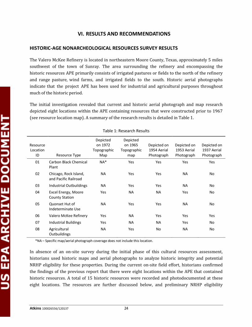
The initial investigation revealed that current and historic aerial photograph and map research depicted eight locations within the APE containing resources that were constructed prior to 1967 (see resource location map). A summary of the research results is detailed in Table 1.
Table 1: Research Results
Resource Location
ID Resource Type
Depicted on 1972
Topographic Map
Depicted on 1965
Topographic map
Depicted on 1954 Aerial Photograph
Depicted on 1953 Aerial Photograph
Depicted on 1937 Aerial Photograph
01 Carbon Black Chemical Plant
NA* Yes Yes Yes Yes
02 Chicago, Rock Island, and Pacific Railroad
NA Yes Yes NA No
03 Industrial Outbuildings NA Yes Yes NA No
04 Excel Energy, Moore County Station
Yes NA NA Yes No
05 Quonset Hut of Indeterminate Use
NA Yes Yes NA No
06 Valero McKee Refinery Yes NA Yes Yes Yes
07 Industrial Buildings Yes NA NA Yes No
08 Agricultural Outbuildings
NA Yes No NA No
*NA – Specific map/aerial photograph coverage does not include this location.
In absence of an on-site survey during the initial phase of this cultural resources assessment, historians used historic maps and aerial photographs to analyze historic integrity and potential NRHP eligibility for these properties. During the current on-site field effort, historians confirmed the findings of the previous report that there were eight locations within the APE that contained historic resources. A total of 15 historic resources were recorded and photodocumented at these eight locations. The resources are further discussed below, and preliminary NRHP eligibility

V. Results and Recommendations
Atkins 100026556/120137 25
recommendations are given for each. Photographs of each resource taken during the field effort is presented in Appendix A.
Resource 01 first appears on the 1937 aerial photograph (TNRIS 1937). The plant is currently operated by the Continental Carbon Company and is located at the intersection of Carbon Black and Pendleton roads, on the north side of Pendleton Road. The plant occupies both the northeastern and northwestern corners of the intersection. Continental Carbon was originally organized as a partnership between R.I. Wishnick, Continental Oil, and Shamrock Oil and Gas in 1936. A list of key milestones on the Continental Carbon website lists 1936 as the construction date for the carbon black plant in Sunray. A pilot plant was constructed at the facility in 1954 to develop new grades of carbon which undoubtedly included the construction of additional equipment and several new buildings (Continental Carbon 2012). The historic map depicts the original plant as consisting of two main buildings with several storage tanks and secondary structures. Current aerial photographs indicate that the plant has expanded substantially, with over 15 new buildings constructed at the site and several buildings appear to have been demolished. Photos taken in 1942 by John Vachon of the Farm Security Administration depict many buildings of the plant. The field effort revealed that the plant has greatly expanded and that the majority of these buildings shown in the Vachon photos are no longer extant. (Clark 2012). These additions, alterations, and demolitions at the plant impact the remainder of the plant’s integrity of setting and feeling. Given the industrial and utilitarian nature of the site, the historic-age building stock does not possess any architectural significance as they are ubiquitous in the region that contains many historic-age refineries. Hence, these resources are not recommended eligible for inclusion in the NRHP under any applicable criteria.
Resource 02 is a spur of the Chicago, Rock Island, and Pacific Railroad, built through the area in the early 1930s by the Amarillo and Canadian River Railroad Company (Willet 2007). The railway was likely constructed shortly after the establishment of the McKee Refinery in 1933, as it appears to have served the refinery and a few years later the Continental Carbon, carbon black plant (Resource 01) only and links these resources to the main rail line to the north. Substantial development observed during the field effort at Resources 01 and 06 has altered the integrity of setting for this resource. Additionally, routine maintenance of the railroad, necessary for its continued function, includes replacing rails and wooden ties, thus reducing its integrity of materials and workmanship. Though the resource maintains a historic association with refinery and thus with industrial development in the area, it does not retain significant integrity merit inclusion in the NRHP. Thus, this resource is not recommended for inclusion in the NRHP under any applicable criteria.
Resource 03 is a grouping of circa 1945 abandoned industrial outbuildings including possible worker housing (03A), a storage silo (03B), office or shop (03C), and windmill pumphouses (03D and E). These resources are located along the west side of the Chicago, Rock Island, and Pacific Railroad spur just north of the McKee Refinery. Given their proximity to the refinery and railroad that served it, these resources may have been associated with the refinery while it was under

V. Results and Recommendations
Atkins 100026556/120137 26
ownership of Diamond Shamrock. These resources do not appear to have been constructed within the first few years of the refinery as they are not present on a 1937 aerial photograph of the area; however, structures are evident at this location on a 1954 aerial photograph of the area (TNRIS 1937, 1953.) All of these resources appear to have been abandoned and thus integrity of association has been lost. Additionally, Resources 03A–B lack integrity of materials, design workmanship, and feeling due recladding, loss of windows, doors, and key components of the resource. The resources may have been associated with the McKee Refinery as housing and industrial outbuildings; however, they do not possess any known significant historic associations to qualify for NRHP inclusion under Criteria A or B. Additionally, none of the resources possess architectural significance and thus do not appear to qualify for NRHP inclusion under Criterion C. Thus, this resource is not recommended for inclusion in the NRHP under any applicable criteria.
Resource 04 is the Excel Energy, Moore County Station located at the northeastern and northwestern corners of the intersection of FM 119 and Light Plant Road. This resource is evident on a 1953 aerial photograph of the area (TNRIS 1953), although comparisons between the 1953 aerial photograph and the 1972 USGS Dumas Northeast, Texas, 7.5-minute topographical map indicate that several buildings were constructed at the location between 1953 and 1972 (USGS 1972). Based on aerial photograph reviews, the plant does not appear to have undergone substantial alterations since 1972. Although the plant appears to retain historic integrity based upon the 1972 map, the resource is not recommended eligible for inclusion in the NRHP under Criterion C because the building stock is utilitarian and industrial, lacking any architectural merit. Additionally, the plant does not maintain any known significant historic associations and thus does not qualify to NRHP inclusion under Criteria A or B. Thus, this resource is not recommended for inclusion in the NRHP under any applicable criteria.
Resource 05 is a circa 1950 Quonset hut of indeterminate use located at the northwest intersection of Road G and the spur of the Chicago, Rock Island, and Pacific Railroad. The structure first appears on a 1954 aerial photograph of the area (TNRIS 1954.) The building appears to retain a high level of integrity; however, the resource is not recommended eligible for inclusion in the NRHP under Criterion C because the building stock is utilitarian and industrial, and lacks architectural merit. Additionally, the building does not maintain any known significant historic associations and thus does not qualify to NRHP inclusion under Criteria A or B.
Resource 06 is Valero’s McKee Refinery, located on FM 119 between Road G and FM 721. The refinery, formerly owned by Diamond Shamrock, dates to 1933 (Valero Marketing and Supply Company 2012). A 1937 aerial photograph of the site depicts the refinery at approximately half of its current size, indicating that the site has expanded dramatically. A 1937 aerial photo of the refinery shows that the Chicago, Rock Island, and Pacific Railroad grade is visible along the western edge of the refinery’s boundary (TNRIS 1937). By 1954, the refinery had expanded well beyond its 1937 boundary, with several structures and tanks located west of the railroad. The 1954 aerial also depicts extensive development at the eastern and southern portions of the site (TNRIS 1954). From

V. Results and Recommendations
Atkins 100026556/120137 27
the 1950s through the present, the refinery has continued to develop, generally to the north, south, and west, as it is bounded by FM 119 to the east. Current aerial photographs depict significant expansion at the site since 1972, which was confirmed during the field effort (USGS 1972). Additionally, as a working facility, the plant is consistently undergoing maintenance, affecting its integrity of workmanship and materials. Additionally, the refinery’s integrity of setting has been compromised by the construction of several phases of wind turbines south and southwest of the refinery. Thus the refinery does not appear to retain sufficient historic integrity to qualify for inclusion in the NRHP under any applicable criteria.
Resource 07 is composed of two large circa 1950 industrial buildings (07A and B) located approximately 0.5 mile southeast of the refinery. The buildings are compressors stations that are associated with the McKee refinery and first appear on a 1954 aerial photograph of the area (TNRIS 1954.) Both structures appear to retain a high level of integrity; however, the resources are not recommended eligible for inclusion in the NRHP under Criterion C because the building stock is utilitarian and industrial, and lack architectural merit. Additionally, the structures do not maintain any known significant historic associations and thus do not qualify to NRHP inclusion under Criteria A or B. Resource 08 consist of a circa 1960 Quonset hut (06A) and a circa 1965 animal pen (06B) located along the north side of FM Road 119 and west FM Road 1284. Both structures appear to retain a high level of integrity; however, neither resource is recommended eligible for inclusion in the NRHP under Criterion C because the building stock is utilitarian and industrial, and lack architectural merit. Additionally, the structures do not maintain any known significant historic associations and thus do not qualify to NRHP inclusion under Criteria A or B.
None of the identified nonarcheological historic-age resources within the proposed project APE appear to possess sufficient integrity and historic significance to merit inclusion in the NRHP under Criterion A, B, or C.
ARCHEOLOGICAL RESOURCES SURVEY RESULTS
Subsequent to Atkins’ historic resources survey, Atkins archeologists conducted archeological investigations of the proposed McKee Refinery Crude Expansion project area. The archeological APE for the proposed undertaking was defined as the footprints of the proposed project improvement areas that will require ground disturbance. All areas surveyed were also considered for potential impacts to archeological deposits associated with potential pipe construction, although the majority of this piping will be located above the ground surface.
The proposed construction areas on the southeast part of the refinery are capped with concrete foundations. These areas include those within the Nos. 1 and 2 Crude Units (Figure 3), the Nos. 1 and 2 Vacuum Units, the HCU, and the RLE unit. The proposed construction areas for the Amine Treating Unit, Storage Tank 1, and the VTDC as well as any piping have been scraped down to pre-Holocene soil. Although proposed construction in these areas may impact the subsurface, previous

V. Results and Recommendations
Atkins 100026556/120137 28
construction most likely has already destroyed any potential archeological deposits. These areas, therefore, were observed and photographed but were not subjected to archeological survey. However, one shovel test was excavated in the Storage Tank 1 area to confirm the degree of disturbance. Although most of the archeological APE was too disturbed to require intensive archeological investigations, a pedestrian survey was conducted in the areas surrounding the proposed locations for Storage Tanks 2 through 8 due to the presence of intact soil. Additionally, three shovel tests were excavated in the area around Storage Tank 2 where ground surface visibility was less than 60 percent. The following section will provide a more detailed description of the areas observed within the archeological APE.
Figure 3. Overview of Nos. 1 and 2 Crude Units Area showing concrete foundation; facing west
A new tank will be constructed in the Acid Plant/Waste Water tank area. This area has 100 percent ground surface visibility and has also been extensively disturbed by scraping and previous pipeline construction and the exposed sediment included calcium carbonate inclusions. No cultural materials were identified or observed at this location.
Most of the proposed tanks will be constructed on the western side of the refinery. The south-westernmost tank, Tank 1, will be situated within an area that has been previously scraped down, removing any potential archeological deposits. In addition to the scraping that has occurred at this location, four 5-foot dikes have been constructed here to contain any spills (Figure 4). Cultural material was identified on the top and sides of one of these dikes; however, the portion of the dike

V. Results and Recommendations
Atkins 100026556/120137 29
containing cultural material is located outside of the proposed APE (see Figure 2). The cultural material observed consisted of a complete Deadman’s arrow point of Edwards chert, an early stage biface fragment of Potter chert, and early to late reduction debitage that included Ogallala chert and quartzite, Dakota quartzite, and occasional Alibates dolomite.
Figure 4. Overview of Tank 1 Area showing graded surface and dikes.
The arrow point of Edwards chert was a dark gray to brown with a light yellowish brown band on the proximal end (Figure 5). It had basal notching that created a straight to slightly expanding stem and long barbs. It had a straight base and the blade had slight serration and blade beveling. The other cultural material included core fragments, core reduction flakes, tertiary late reduction flakes and flake fragments, as well as the crude early stage biface fragment mentioned above. All of the cultural material on the dike was imported from an unknown location in the process of dike construction and maintenance. A shovel test (ST01; Table 2) at the base of the dike confirmed the area had been scraped down, removing all Holocene sediment, and that no cultural deposition occurs in the area. According to the personnel at the Valero McKee refinery, in recent years, the sediment used for the construction of dikes was routinely brought in to the refinery from a location off-site. The Project Archeologists concluded that the source of cultural materials was from an off-site quarry used to construct and maintain these dikes, and this quarrying has impacted an archeological site probably dating to the Palo Duro Complex, A.D. 200 to 1000, based on the Deadman’s arrow point. It is likely not far away since the lithic materials are typical of the region.

V. Results and Recommendations
Atkins 100026556/120137 30
Figure 5. Deadman’s Arrow Point
Table 2: Shovel Testing at the McKee Refinery
Shovel Test # Depth Description
ST01 0–15 cm dark yellowish brown sandy clay loam with calcium carbonate inclusions
ST02 0–20 cm dark yellowish Brown sandy loam
20–30 cm dark yellowish brown clay loam with calcium carbonate inclusions
ST03 0–20 cm dark yellowish brown sandy loam
20–30 cm dark yellowish brown clay loam with calcium carbonate inclusions and caliche gravels
ST04 0–20 cm dark yellowish brown sandy loam
20–30 cm dark brown sandy clay
A large dike located on the western part of the refinery will be modified to contain three new tanks (Tanks 2–4). This area is situated along the east bank of South Palo Duro Creek. The area where the dike will extend and where Tank 2 will be placed is on the east side of the existing dike, in an area with poor visibility (ranging from 0 to 20 percent) with occasional patches of greater visibility (Figure 6). Three shovel tests (ST 02–04; see Table 2) extending to 30 cm in depth were excavated (see Figure 2). No cultural materials were encountered. Shovel test excavations indicated thin

V. Results and Recommendations
Atkins 100026556/120137 31
Holocene deposits with underlying Pleistocene sediment and was terminated when sandy clay loam B Horizon sediment was encountered. Soils in this area consisted of Paloduro-Sunray complex, 5 to 8 percent slopes soils. These sandy loam and clay loam soils are derived from ancient alluvial and eolian sediments and occur on interfluves on the plains. The presence of thin Holocene deposits, which appear colluvial in nature, overlying these ancient soils is likely the result of the modern dike construction and other modifications undertaken by Valero to the natural landscape in this area of the refinery.
Figure 6. Overview of Tank 2 Location Area showing poor ground surface visibility; facing north.
Along the northern and western edge of the dike, the ground surface visibility ranged from 80 to 100 percent visibility. This area has been heavily eroded with caliche and other gravel exposed on the surface. Additional disturbance from prior petroleum pipeline and road construction occurred on the north side. The area where Tank 3 will be constructed has been impacted by severe soil deflation, as well as by road and water well construction. The location of Tank 4 is within a previously constructed dike and will be adjacent to existing tanks. This area has a large borrow pit probably from previous construction of the dike. It also includes some intact upland areas that have been deflated by erosion and have caliche and other gravels exposed on the surface. No cultural materials were noted.
Tanks 5, 6, 7, and 8 are located northwest of Tank 4. Tanks 5 and 7 are located on an upland side slope with 50 to 90 percent ground surface visibility. The sloped area also included a buried petroleum pipeline and concrete pad with electrical boxes. Tank 6 (Figure 7) is located on an

V. Results and Recommendations
Atkins 100026556/120137 32
upland and a slope with road and pipeline disturbances, as well as erosion. The soils in the area where these tanks will be placed consists of Paloduro-Sunray complex 5 to 8 percent slopes loam and clay loam, Paloduro-Sunray complex 3 to 5 percent slopes loam and clay loam, and Sherm silty clay loam. These soils are alluvial and eolian deposits of Pliestocene-age. There were several patchy areas with very good visibility amidst the grassy areas with poor visibility and erosion. No shovel testing was conducted and the pedestrian survey identified no cultural materials.
Figure 7. Overview of Tank 6 Area showing severe soil deflation caused by erosion; facing east.
The location for Tank 8 (Figure 8) is located southwest of Tank 6 and falls within a large depression that was probably a borrow pit used for the construction of dikes or other purposes. The depression had steep sided walls on the east and north sides, and within the depression, there are piles of gravels and other materials, as well as a pad and wellhead associated with an oil well that is no longer in use. The portion of the Tank 8 APE that was not removed by previous excavation was comprised of Paloduro-Sunray complex 3 to 5 percent slopes, loam and clay loam soils, and Sherm silty clay loam soils. No cultural materials were identified.
The VTDC (Figure 9) was also observed by Atkins archeologists; however, all constructions and improvements within this facility were completed prior to Atkins’ archeological survey of the McKee Refinery Crude Expansion project area . This area has been built up for the use of railroad loading and offloading and has been extensively disturbed. Foreign gravels cover the surface. Buildings, tanks, pipelines, and railroad tracks have been constructed in this area. Based on the high degree of disturbance, no potential archeological deposition remains intact.

V. Results and Recommendations
Atkins 100026556/120137 33
Figure 8. Overview of Tank 8 Area showing large borrow pit with steep side walls; facing northwest.
Figure 9. Overview of VTDC Area showing previously constructed
railway loading area and pipelines; facing south.

V. Results and Recommendations
Atkins 100026556/120137 34
Atkins’ archeological investigations of the proposed McKee Refinery Crude Expansion Project found no archeological deposits or cultural resources sites within the APE Although prehistoric artifacts were observed within the boundaries of the refinery, these artifacts were located outside the of the footprints of the proposed undertakings and were the result of secondary deposition from a site of unknown location as a result of the process of dike construction. This area is therefore not considered an archeological site, and no further work is recommended.
Since none of the identified nonarcheological historic-age resources within the proposed project APE appear to possess sufficient integrity and historic significance to merit inclusion in the NRHP under Criterion A, B, or C, and no archeological sites were located within the project APEs, Atkins recommends no further work is necessary for cultural resources. Atkins further recommends the areas investigated be cleared for construction to proceed.

Atkins 100026556/120137 35
REFERENCES CITED
Abbe, D.R. 2012 The Handbook of Texas Online, s.v., “Moore County,” http://www.tshaonline.
org/handbook/online/articles/hcm18 (accessed February 9, 2012).
Anderson, H.A. 2012a The Handbook of Texas Online, s.v., “Dumas, TX,” http://www.tshaonline.org/
handbook/online/articles/hed06 (accessed February 9, 2012).
2012b The Handbook of Texas Online, s.v., “Sunray, TX,” http://www.tshaonline.org/ handbook/online/articles/hjs33 (accessed February 9, 2012).
Baugh, T.T. (editor), S.M. Berta, P. Flynn, J.A. Harrington, and M.C. Moore. 1984 Archaeology of the Mixed Grass Prairie Phase I: Quartermaster Creek, Oklahoma.
Archaeological Survey, Archaeological Resource Survey Report No. 20. Norman.
Boyd, D.K. 1997 Caprock Canyonlands Archeology: A Synthesis of the Late Prehistory and History of
Lake Alan Henry and the Texas Panhandle-Plains. Reports of Investigations No. 110, 2 vols. Prewitt & Associates, Inc., Austin.
Clark, T. 2012 Tom Clark Blog Spot. John Vachon: Like Driving into the Middle of the Night
http://tomclarkblog.blogspot.com/2012/04/john-vachon-like-driving-from-sunny-day.html (accessed November 2012).
Collins, M.B. 1966 The Andrews Lake Sites: Evidence of Semi-sedentary Prehistoric Occupation in
Andrews County, Texas. Transactions of the Second Regional Archeological Symposium for southeastern New Mexico and Western Texas, Bulletin 2, pp. 27–43. Lea County Archeological Society Hobbs, New Mexico.
1968 The Andrews Lake Locality: New Archaeological Data from the Southern Llano Estacado, Texas. MA thesis, Department of Anthropology, The University of Texas at Austin.
1969 A Note on Brad Corner-notched Projectile Points Used in Bison Hunting in Western Texas. South Plains Archeological Society News Bulletin 21:2–4.
1971 A Review of Llano Estacado Archeology and Ethnohistory. Plains Anthropologist 16(52):85–104.
Continental Carbon 2012 Key Milestones. http://www.continentalcarbon.com/company/key-milestones.asp
(accessed November 2012).

References Cited
Atkins 100026556/120137 36
Corley, J.A. 1965 Proposed Eastern Extension of the Jornada Branch of the Mogollon. Transactions of
the First Regional Symposium for Southeastern New Mexico and Western Texas, Bulletin 1, pp. 31–36. Lea County Archeological Society, Hobbs, New Mexico.
Couzzourt, J.E. 1982 Archaeological Testing at Cal Farley’s Boys Ranch, Oldham County, Texas.
Transactions of the 17th Regional Archaeological Symposium for Southeastern New Mexico and Western Texas, pp. 57–134. Midland Archaeological Society, Midland, Texas.
Cruse, J.B. 1992 Archeological Investigation at the Kent Creek Site (41HL66). Panhandle Archeological
Society Publication No. 6, Amarillo.
2008 Battles of the Red River War: Archeological Perspectives on the Indian Campaign of 1874. Texas A&M University Press, College Station.
Cruse, J.B., C.S. Weed, and M.E. Cruse 1993 Cultural Resources Survey of the Proposed 21.6 Mile Loop Storage to Red River 20-inch
Pipeline, Gaines and Dawson Counties, Texas. EMANCO, Inc. Report of Archaeological Investigations No. 29.
Davis, W. 1985 Appraisal of the Archeological Resources of Sanford Reservoir Hutchinson, Moore,
and Potter Counties, Texas. Publication No. 3. Panhandle Archaeological Society, Amarillo.
Etchieson, G.M. 1981a Archeological Survey at Lake Meredith Recreation Area, Moore and Potter Counties,
Texas. US Department of the Interior, Water and Power Resources Services, SW Region, Amarillo.
1981b Letter Report - Field Notes from Shoreline Survey of Selected Parts of Lake Meredith. Report on file at the THC (Vol. 1), Austin.
Etchieson, G.M., and J.E. Couzzourt 1987 Shoreline Survey at Lake Meredith Recreation Area in the Texas Panhandle. Bureau
of Reclamation, Amarillo.
Figgins, J.D. 1927 The Antiquity of Man in America. Natural History 27(3):229–239.
Green, F. 1986 Report on Archaeological Salvage in the Sanford Reservoir Area. Publication No. 4.
Panhandle Archeological Society, Amarillo.

References Cited
Atkins 100026556/120137 37
Haecker, C.M. 1992 Cultural Resource Survey, Fritch Fortress, Cedar Canyon, Basin and Blue West, Lake
Meredith National Recreation Area, Texas. National Park Service, Santa Fe.
Harrison, B. 1984 Archeological Survey on a Proposed 8.5 Miles Liquid Hydrocarbon Pipeline. Report
on file at the Texas Historical Commission, Austin.
Harrison, B.R., and K.L. Killen 1978 Lake Theo: A Stratified, Early Man Bison Butchering and Camp Site, Briscoe County,
Texas. Archeological Investigations, Phase II. Panhandle-Plains Historical Museum, West Texas State University, Canyon.
Harrison, B.R., and H.C. Smith 1975 A Test Excavation of the Lake Theo Site, Briscoe County, Texas. Panhandle-Plains
Historical Review 48:70–108.
Hofman, J.L. 1984 The Plains Villagers: the Custer Phase. In Prehistory of Oklahoma, edited by Robert
Bell, pp. 287–306. Academic Press, New York.
Hester, J.J. 1972 Blackwater Locality No. 1: A Stratified Early Man Site in Eastern New Mexico. Fort
Burgwin Research Center, Southern Methodist University, Dallas.
Holliday, V.T. 1987 Cultural Chronology in Lubbock Lake: Late Quaternary Studies on the Southern High
Plains. Texas A&M University Press, College Station.
Hughes, J. 1969 The Canyon City Club Cave, Randall County, Texas. Manuscript on file at the Texas
Historical Commission, Austin.
1972 Archeological Survey of the Schroeter Industrial Park. Letter Report. West Texas State University, Canyon.
1973 Data for Archeology Section of Environmental Impact Statement on Blue West and Bates Canyon Areas, Lake Meredith Recreation Area, Texas. West Texas State University, Canyon.
1991 Prehistoric Cultural Development on the Texas High Plains. Bulletin of the Texas Archeological Society 60:1–56.
Hughes, J.T., and P.S. Willey 1978 Archeology at Mackenzie Reservoir. Archeological Survey Report No. 24. Texas
Historical Commission, Austin.

References Cited
Atkins 100026556/120137 38
Horvath, M. 2012 Memo: Environmental Protection Agency’s comments on a Biological Assessment
and Cultural Resources Evaluation for Valero’s McKee Refinery Crude Expansion Project, and cost estimates to implement requested edits. Atkins, July 2012.
Johnson, E., and V.T. Holliday 1985 A Clovis Age Megafaunal Processing Station at the Lubbock Lake Landmark. Current
Research in the Pleistocene No. 2:17–19.
Katz, S. 1994 Cultural Resources Identification Survey at Proposed Locations for Drilling and
Pipeline Facilities. State Lease CR6-2B, Lake Meredith Recreation Area, Moore and Potter Counties, Texas. PRIAM, Panhandle.
McWhorter, A. 2012 Historic Resources Historic Map and Aerial Photograph Study the Valero McKee
Refinery Sunray Vicinity, Moore County, Texas.
New World Research 1981 A Cultural Resources Survey of the Proposed Transanadarko Pipeline System Texas,
Oklahoma, Arkansas, Louisiana, Vol. I. Report of Investigations No. 37. New World Research, Inc., Pollock.
Peyton, A. 2008 An Intensive Cultural Resources Survey of the USACE Jurisdictional Areas within the
7-mile Eagle Rock Stinnett to Cargray Pipeline ROW, Hutchison and Moore Counties, Texas. Report No. HJN 07186 AR. Horizon Environmental Services, Inc., Austin.
Phillips, J.W. 1985 Excavated Sites Near Lake Meredith. Publication No. 2. Panhandle Archeological
Society, Amarillo.
Phippen, G.R. Jr., C.L. Wase, A.B. Herder, C.J. Zier, M. McFaul, G.D. Smith, and E.D. Herder 1985 Archaeological Inventory, Test Excavations, Construction Monitoring, and Geo-
morphological Overview of the D.S.E. El Paso Pipeline, Texas and New Mexico. Centennial Archaeology, Inc., Fort Collins.
Orval, E.S., M.A. Latham, and S.M. Houghton 2005 Cultural Resources Survey of Abandonment of NNG Beaver Pipeline for FERC 7B
Permitting: Texas. Project No. 38777. Burns & McDonnell Engineering Company, Inc., Kansas City.
Pool, K.J. 1991 Class III Cultural Resource Inventory of the Proposed Colorado Interstate Gas Company
Panhandle Field Compressor #24 and 4 Fuel Gas Line, Moore County, Texas. Metcalf Archaeological Consultants, Inc., Eagle.

References Cited
Atkins 100026556/120137 39
Rathjen, F.W. 2009 Handbook of Texas Online, s.v. “Panhandle,” http://www.tshaonline.org/handbook/
online/articles/PP/ryp1.html (accessed May 7, 2009).
Runkles, F.A. 1964 The Garza Site: A Neo-American Campsite near Post, Texas. Bulletin of the Texas
Archeological Society 35:101–125.
Sellards, E.H. 1938 Artifacts Associated with Fossil Elephant. Bulletin of the Geological Society of
America 49:999–1010.
1955 Fossil Bison and Associated Artifacts from Milnesand, New Mexico. American Antiquity 20(4):336–344.
Sellards, E.H., G.L. Evans, and G.E. Meade 1947 Fossil Bison and Associated Artifacts from Plainview, Texas. Bulletin of the
Geological Society of America 58:927–954.
Smith, Julia Cauble 2012 The Handbook of Texas Online, s.v., “Panhandle Field,” http://www.tshaonline.
org/handbook/online/articles/dop01 (accessed February 9, 2012).
State Department of Highways and Public Transportation (SDHPT) 1975 Cultural Resources Assessment – IPE 416 and 423 – US 287: from Dumas to
Stratford. Letter Report, State Department of Highways and Public Transportation, Austin.
1982 Cultural Resources Assessment; FM 3395: From 1 Mile N of Sanford Dam, West and North to FM 1913. Letter Report. State Department of Highways and Public Transportation, Austin.
Suhm, D.A., and E.B. Jelks 1962 Handbook of Texas Archeology: Type Descriptions. Texas Memorial Museum Bulletin
No. 4. Austin.
Tunnell, C. 1977 Fluted Projectile Point Production as Revealed by Lithic Specimens from the Adair-
Steadman Site in Northwest Texas. In Paleoindian Lifeways, edited by Eileen Johnson. West Texas Museum Association, Lubbock, Texas.
Texas Department of Transportation (TxDOT) 1993 SH 152: Maintenance Yard. Texas Department of Transportation, Austin.
1996 Archaeological Resources Survey Report on FM 199 from Station212+50 East 3.3 miles to FM 1284. Texas Department of Transportation, Austin.

References Cited
Atkins 100026556/120137 40
Texas Natural Resource Information System (TNRIS) 1937 Coverage of APE in Moore County.
1953 Coverage of APE in Moore County.
1954 Coverage of APE in Moore County.
Texas State Highway Department 1936 General Highway Map, Moore County, Texas. Accessed at the Texas State Library and
Archives Commission Historic Map Collection. https://www.tsl.state.tx.us/arc/ maps/images/map4957.jpg (accessed February 8, 2012).
Turner, E.S., and T.R. Hester 1985 A Field Guide to Stone Artifacts of Texas Indians. 2nd edition. Texas Monthly Press,
Austin.
United States Department of Agriculture (USDA) 2012 Soil Survey of Moore County, Texas. https://soilseries.sc.egov.usda.gov/ (accessed
March 18, 2013).
United States Geological Survey (USGS) 1965 Dumas North, Texas, 7.5-minute Quadrangle Map.
1972 Dumas Northeast, Texas, 7.5-minute Quadrangle Map.
University of Texas at Austin 1981 Bureau of Economic Geology, Geologic Atlas of Texas, Amarillo Sheet. The University
of Texas at Austin.
Valero 2011 Prevention of Significant Deterioration Permit Application for the Crude Expansion
Project: Valero McKee Refinery. Submitted to Texas Commission of Environmental Quality, December.
Valero Marketing and Supply Company 2012 McKee. http://www.valero.com/OurBusiness/OurLocations/Refineries/Pages/
McKee.aspx (accessed February 8, 2012).
Wase, C.L. (editor) 1995 The Proposed DSE El Paso Pipeline Project, Dumas to El Paso, Texas: A Preliminary
Report of the Cultural Survey Fort Collins. Antiquities Permit No. 1425. Centennial Archaeology, Inc., Fort Collins.
Wedel, W.R. 1961 Prehistoric Man on the Great Plains. University of Oklahoma Press, Norman.
1975 Chalk Hollow: Culture Sequence and Chronology in the Texas Panhandle. Actas del XLI Congreso Internacional de Americanistas 1:271−278. Mexico, D.F.

References Cited
Atkins 100026556/120137 41
Wermund, E.G. 1996 Physiographic Map of Texas. Bureau of Economic Geology, The University of Texas
at Austin.
Willet, Matt 2007 Rock Island’s Family Tree. http://home.covad.net/scicoatnsew/rihist6.htm
(accessed November 2012).
Wormington, H.M. 1957 Ancient Man in North America. Museum of Natural History, Popular Series No. 4,
Denver.

Appendix A
Resource Documentation Photographs

Appendix A: Resource Documentation Valero’s McKee Refinery Crude Expansion Project
Sunray, Moore County, Texas
A‐1
View of Resource 01 (Carbon Black Plant), facing northwest
View of Resource 01 (Carbon Black Plant), facing northeast
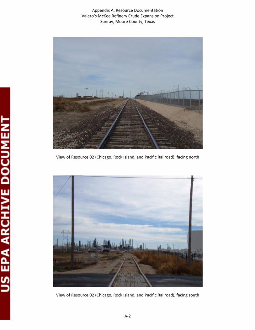
Appendix A: Resource Documentation Valero’s McKee Refinery Crude Expansion Project
Sunray, Moore County, Texas
A‐2
View of Resource 02 (Chicago, Rock Island, and Pacific Railroad), facing north
View of Resource 02 (Chicago, Rock Island, and Pacific Railroad), facing south

Appendix A: Resource Documentation Valero’s McKee Refinery Crude Expansion Project
Sunray, Moore County, Texas
A‐3
View of Resource 03A, facing west
View of Resource 03A, facing southwest

Appendix A: Resource Documentation Valero’s McKee Refinery Crude Expansion Project
Sunray, Moore County, Texas
A‐4
View of Resources 03B, C and D, facing west
View of Resource 03C, facing northwest

Appendix A: Resource Documentation Valero’s McKee Refinery Crude Expansion Project
Sunray, Moore County, Texas
A‐5
View of Resources 03D and E, facing west
View of Resource 04 (Xcel Energy Moore County Station), facing northeast

Appendix A: Resource Documentation Valero’s McKee Refinery Crude Expansion Project
Sunray, Moore County, Texas
A‐6
View of Resource 04 (Xcel Energy Moore County Station), facing northwest
View of Resource 04 (Xcel Energy Moore County Station), facing north

Appendix A: Resource Documentation Valero’s McKee Refinery Crude Expansion Project
Sunray, Moore County, Texas
A‐7
View of Resource 05, facing west
View of Resource 05, facing northwest

Appendix A: Resource Documentation Valero’s McKee Refinery Crude Expansion Project
Sunray, Moore County, Texas
A‐8
View of Resource 06 (McKee Refinery), facing southeast
View and setting of Resource 06 (McKee Refinery), facing north

Appendix A: Resource Documentation Valero’s McKee Refinery Crude Expansion Project
Sunray, Moore County, Texas
A‐9
View and setting of Resource 06 (McKee Refinery), facing north
View of Resources 07A and B, facing southeast
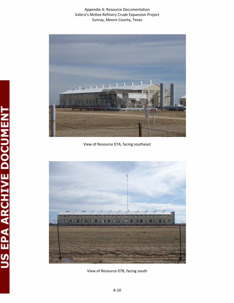
Appendix A: Resource Documentation Valero’s McKee Refinery Crude Expansion Project
Sunray, Moore County, Texas
A‐10
View of Resource 07A, facing southeast
View of Resource 07B, facing south

Appendix A: Resource Documentation Valero’s McKee Refinery Crude Expansion Project
Sunray, Moore County, Texas
A‐11
View of Resource 08A, facing northwest
View of Resource 08A, facing north

Appendix A: Resource Documentation Valero’s McKee Refinery Crude Expansion Project
Sunray, Moore County, Texas
A‐12
View of Resource 08B, facing north
View of Resource 08B, facing northwest

Appendix B
Résumés

Virginia Hatfield, Ph.D. Archeologist Hatfield Consulting Education Ph.D., Anthropology, University
of Kansas, Lawrence, Kansas, 2006
M.A., Anthropology, University of Kansas, Lawrence, Kansas, 2001
B.A., History, Texas Tech University, Lubbock, Texas, 1993
B.A., Physics (60 hours), University of Arkansas, Fayetteville, Arkansas, 1988-1990.
Professional Affiliations Register of Professional
Archaeologists (RPA) Society for American
Archaeologists (SAA) Council of Texas Archeologists
(CTA) Texas Archeological Society
(TAS), Director of Region 2 Alaska Anthropological
Association (AAA) Department of Sociology,
Anthropology, and Social Work, Texas Tech University, Adjunct
Museum of Natural History, University of Kansas, Adjunct.
Dr. Hatfield has more than over 16 years of experience conducting archaeological investigations throughout Texas, Kansas, Arizona, Missouri, Ohio, and Alaska. Her area of expertise is lithic technology, and she has experience working on both prehistoric and historic archaeological sites for various regulatory agencies. Dr. Hatfield has experience working within a variety of regulatory contexts, including Section 106 of the NHPA, the Antiquities Code of Texas, and the Texas Health and Safety Code. She is also very active in professional organizations and education. Selected recent projects: 2012
Lamar County, Texas. Caddo archaeologist assisting in excavations of part of the Sanders site, for SWCA. Sept-Oct 2012.
Titus County, Texas. Monitoring stripping excavations at 41TT906. July 2012
Waco, Texas. Trench excavations at the location of the proposed new Baylor University football stadium in Waco, Texas May 2012.
Rusk County, Texas. An Intensive Archeological and Historical Resources Survey of 4800 Acres in Area W of the Sabine Mine's South Hallsville No. 1 Mine, Rusk County, Texas. March-May, 2012.
2010 Mount Pleasant, Texas. Project Archeologist, Field Director. Data
Recovery Excavations of three sites along Tankersley Creek for the US Highway 271 Mt Pleasant relief route. January-June 2010. Artifact analysis and write up of testing and data recovery findings. June, 2010-February 2012. Prewitt and Associates, Inc.
2009 Marshall, Texas. Project Archeologist. Test Excavations of three sites
within the Sabine mine. November-December, 2009. Prewitt and Associates, Inc.
Fort Hood, Texas. Project Archeologist. Excavations of three sites with burned rock middens within Fort Hood. May-July, 2009. Prewitt and Associates, Inc.
Lubbock, Texas Project Archeologist. Survey of two possible locations for the location of an animal shelter within the city of Lubbock, Texas. Prewitt and Associates, Inc.
Lubbock, Lamb, and Garza Counties, Texas. Project Archeologist. Survey of a water pipeline from Lake Alan Henry to the city of Lubbock and report writing. February-March, 2009. Prewitt and Associates, Inc.
Brazoria, Texas Project Archeologist. Excavations at the Pioneer Cemetery. January, 2009. Prewitt and Associates, Inc.
Selected recent publications: No date Hatfield, Virginia, Ross Fields, Damon Burden, Eloise Gadus,
and Karl Kibler. Mt Pleasant Loop 271 Testing of 11 Sites and Data Recovery of 3 Sites along Tankersley Creek, Titus County, Texas. In possession of the authors. Prewitt and Associates. Inc.
2012 Hatfield, Virginia, Charles Frederick, Brittney Gregory, and Karl
Kibler. Archeological and Geoarcheological Investigations for the New Baylor University Football Stadium in Waco, McLennan

Virginia Hatfield, Ph.D. Archeologist
County, Texas. Technical Report No. 88. Prewitt and Associates, Inc.
West, Dixie, Virginia Hatfield, Elizabeth Wilmerding, Christine
Lefèvre, Lyn Gualtieri (eds.) The People Before: The Geology, Paleoecology and Archaeology of Adak Island, Alaska. Oxford, British Archaeological Reports, International Series 2322.
Wilmerding, Elizabeth and Virginia Hatfield. Chapter 12: Six
Thousand Years of Lithic Technology on Adak in a Broader Aleutian Context. In The People Before: The Geology, Paleoecology and Archaeology of Adak Island, Alaska, pages 211-237. Oxford, British Archaeological Reports, International Series 2322.
2011 Hatfield, Virginia. Western Aleutian Chipped Stone Technology
and the Colonization of the Aleutian Archipelago. Arctic Anthropology, 48(2):113-125
2010 Hatfield, Virginia. Material Culture Across the Aleutian
Archipelago. In Human Biology 82(5-6): 525-556. 2009 Douglas Boyd, Aaron Norment, and Virginia Hatfield.
Archeological Survey of the Proposed Lake Alan Henry to Lubbock Water Pipeline, Garza, Lynn, and Lubbock Counties. Prewitt and Associates, Inc.
Virginia Hatfield. Archeological Survey of a Proposed Location
for an Animal Shelter on Southeast Loop 289, City of Lubbock, Lubbock County, Texas. Prewitt and Associates, Inc.
Hatfield, Virginia. Archeological Survey of a Proposed Location
for an Animal Shelter at MacKenzie Park, in the City of Lubbock, Lubbock, Texas. Prewitt and Associates, Inc.
Virginia Hatfield and Douglas Boyd. Archeological Surveys of
Proposed Wastewater Development Projects Along Flat Creek and Bull Hide Creek, McLennan County, Texas. Prewitt and Associates, Inc.

M. Kelley Russell Architectural Historian/ Archeologist Atkins Education M.S., Historic Preservation,
University of Texas at Austin, 2011
B.A., Anthropology and Archeology, University of Texas at Austin, 2000
Professional Development Section 106, Advisory Council on
Historic Preservation, 2010 CEQA Basics Workshop, 2012
Professional Affiliations Association for Preservation Technology (APT) National Trust for Historic Preservation (NTHP) Preservation Texas Heritage Society of Austin
Ms. Russell has more than nine years of professional experience with Atkins’ cultural resource management division. She has been an integral part of the archeology program, conducting prehistoric and historic archeological fieldwork, including survey, testing and mitigation. However for the last four years, Ms. Russell has expanded her capabilities as an architectural historian in Atkins’ Historic Resources Group. Her current duties in this capacity include historic-age building documentation, assessment, and analysis, historic context development, visual impact assessments, historic landscape evaluations, and archival research. Ms. Russell recently completed her Master of Science degree in Historic Preservation at the University of Texas at Austin with an emphasis of materials conservation. Ms. Russell’s work at the University included an NRHP nomination for a campus building, HABS Level I Documentation of a former US Courthouse and Post Office, and conditions assessment and repair of historic gravestones on Cape Lookout National Seashore, North Carolina. Ms Russell’s experience also includes a preservation field school with Tulane University which included courses on Louisiana architecture and the restoration of the Taylor Tomb in Lafayette Cemetery No.1. Ms. Russell recently completed her thesis titled: Conditions Assessment and Treatment Recommendations for the Main Building of the Austin State Hospital. Below are narrative descriptions of select relevant projects highlighting Ms. Russell’s experience in conducting cultural resource and historic preservation projects. In addition to these projects, Ms. Russell has served as a lead historian and architectural historian on a number of projects in Texas, Arkansas, and Alaska and has worked as a historian on projects in Oklahoma and California. National Register of Historic Places (NRHP) Nomination for University of Texas Campus Building, Travis County, Texas, Ongoing. Ms. Russell completed an NRHP nomination for Parlin Hall, the English Building on the University of Texas at Austin campus. Parlin Hall is located within the original 40 acres of campus designed by architect Paul Cret. The nomination entailed extensive research of history of the building, building materials, associate and consulting architects, and architectural history of the university campus. HABS Level I Documentation of O. Henry Hall, Travis County, Texas, Ongoing. Ms. Russell is currently completing HABS Level I documentation of O. Henry Hall, which currently houses the University of Texas Board of Regents. O. Henry Hall was constructed in 1881 and served as the first Federal Courthouse and permanent U.S. Post Office in Austin, Texas. Ms. Russell’s documentation of O. Henry Hall included large format photography and hand measurements of the exterior and interior of the building to produce hand drafted ink on mylar drawings for submittal to the National Park Service. Ms. Russell also conducted archival research to investigate the building’s uses and occupants during its lifetime for inclusion in the historic report accompanying the drawings. HABS Level III Mitigation for NRHP-Eligible Selman Farmstead and Selman Barnett Farmstead, Panola County, Texas (2006-2008). The Selman and Selman-Barnett Farmsteads were located within Luminant Martin Lake Lignite Mine Permit 4I Boundary area in Panola County, Texas. Both farmsteads were determined eligible for listing in the NRHP by the Texas Historical Commission based upon information presented by Atkins in a 2006 archeological survey report of the proposed mine area. In order to mitigate the adverse affects to

M. Kelley Russell Historian, Archeologist Atkins
the resources, Atkins’ historic resource group conducted fieldwork and archival research resulting in a HABS Level III documentation report to the SHPO. Ms. Russell contribution to this project included conducting large format photography, digital photography, creating scaled floor plans, and site maps. She also conducted archival research for this project.
Conditions Assessment, Treatment Recommendation and Repairs of Seven Historic Cemeteries of Portsmouth Village, Cape Lookout National Seashore, North Carolina (2012). The University of Texas Historic Preservation Graduate Program was awarded a contract with the National Park Service to conduct conditions assessments and treatment plans of seven historic cemeteries at historic Portsmouth Village, Cape Lookout National Seashore. Ms. Russell’s role as lead student conservator included documentation, cleaning, and repair of over 100 gravestones in a coastal environment.
Completion Report: Galveston Seawall and Groins Repair Project, Galveston, Galveston County, Texas (2010). Following Hurricane Ike’s landfall in 2008 the Galveston Seawall and Groin System was found to have significant damage at various locations. The rehabilitation project included repairs that restored the Seawall system to its pre- storm condition to provide the authorized/ intended level of protection. Ms. Russell served as part of the Atkins team that documented the rehabilitation and repairs to the Seawall in a Completion Report pursuant to the Antiquities Code of Texas.
Reconnaissance Level Survey of Additional Alternatives for IH-10 at White Oak Bayou Detention Ponds Project, Houston District, Harris County Texas (2011). Ms. Russell was directly involved in all aspects of the reconnaissance-level historicstanding structures component of this project prior to the construction of several flood mitigation ponds along White Oak Bayou at Interstate Highway 10 in Harris County, Texas for TxDOT’s Houston District. She, directed the recordation of historic-age resources, performed NRHP eligibility analyses, and conducted historic research in support of a historic context development. Ms. Russell also administered aspects of the standing structures project including, report compilation, and client coordination.
An Intensive Cultural Resource Survey of the Proposed Northwest Texarkana 345-kV Transmission Lines, Little River and Hempstead Counties, Arkansas (2012). Ms. Russell was directly involved in the reconnaissance-level historic standing structures component of this large-scale, linear project. She was part of a team that recorded historic-age resources within a .5 mile APE along a 21 mile corridor, performed NRHP eligibility analyses, and conducted historic research in support of a historic context development.
Historic Resources Reconnaissance Survey of Proposed Easement and Pedestrian Overpass Locations, US 183 from RM 620 to SH 71, Travis County, Texas (2009). Atkins conducted this reconnaissance-level survey for historic resources that couldbe affected by the acquisition of 31 proposed easement locations and the construction of one proposed pedestrian bridge along US Highway (US) 183 between Ranch to Market Road (RM) 620 and State Highway (SH) 71. Ms. Russell’s involvement with this project included recordation of historic-age resources and NRHP eligibility analyses.

M. Kelley Russell Historian, Archeologist Atkins
Historic San Antonio Mission Trails Transportation Enhancement Project, San Antonio, Bexar County, Texas (2010-2011) This project involved resurvey of previously documented historic resources and documentation and assessment of previously unrecorded resources along a 10-mile hike-and-bike trail beginning in downtown San Antonio and extending south through the city’s historic Spanish Mission districts. Ms. Russell and other project historians updated previous survey efforts through re-documentation and assessment of over 250 properties dating from the Spanish Colonial period through the mid-twentieth century. Many of the properties were NRHP-listed, either individually or as part of large residential, commercial, and/or religious NRHP districts, and several, including portions of original Spanish Missions, included resources designated as National Historic Landmarks. Historians also recorded and assessed several previously unrecorded historic districts and coordinated project effects under Section 106 and Section 4(f) with City of San Antonio Historic Preservation Office Staff and reviewers at TxDOT and the THC.
Tevyar’aq Railway Tram Repair Project, Bethel District, Alaska The Western Federal Lands Highway Division of the Federal Highway Administration, in cooperation with the Denali Commission, propose to repair and reconstruct the existing Tevyar’aq Railway Tram located in the Yukon Delta National Wildlife Refuge, approximately 40 miles west of Bethel, Alaska. The boat tram is a key element along a traditional subsistence route for the surrounding villages as a waterway connection to the Baird Inlet and Bering Sea. Ms. Russell served as the lead architectural historian for this project, evaluating the tram for NRHP eligibility under Section 106 and the surrounding landscape within the APE for eligibility as a Traditional Cultural Property.
Head Cemetery Relocation Project, Robertson County, Texas (Ongoing) Ms. Russell served as an archaeological crew chief for burial excavations and as the lead conservator for gravestone repair on this historic cemetery data recovery project in Robertson County, Texas. Ms. Russell directed all aspects of headstone removal, cleaning, and repair, supervising technicians and other professional staff. She also participated in laboratory cleaning and analysis of historic artifacts and osteological remains recovered from over 100 burials.
City of Trinity Pedestrian Trail Project Trinity, Trinity County, Texas (2012) Prior to sidewalk improvements and installation within the city of Trinity, Atkins conducted this reconnaissance-level survey for historic resources for TxDOT’s Lufkin District in accordance with Section 106. Ms. Russell’s role as an architectural historian on this project included historic context development, recordation of historic-age resources and NRHP eligibility analyses.
Tununak Community Streets Project, Bethel District, Alaska (Ongoing) The Western Federal Lands Highway Division of the Federal Highway Administration, in cooperation with the Denali Commission, propose to construct a boardwalk road in the village of Tununak within the Yukon Delta National Wildlife Refuge, approximately 40 miles west of Bethel, Alaska. Ms. Russell served as the lead architectural historian for this project in determining the potential for effects on cultural resources associated with the proposed project, and to support future, project-related compliance with Section 106.

M. Kelley Russell Historian, Archeologist Atkins
Holy Cross Community Road Project, Bethel District, Alaska (Ongoing) The Western Federal Lands Highway Division of the Federal Highway Administration, in cooperation with the Federal Lands Highway (FLH), Indian Reservation Roads (IRR) Program, propose to construct a new road in the village of Holy Cross within the Yukon Delta National Wildlife Refuge, approximately 120 miles northeast of Bethel, Alaska. Ms. Russell served as the lead architectural historian and as an archeological technician for this project in determining the potential for effects on cultural resources associated with the proposed project, and to support future, project-related compliance with Section 106.
Ruby Slough Road Project, Bethel District, Alaska (Ongoing) The Western Federal Lands Highway Division of the Federal Highway Administration, in cooperation with the Federal Lands Highway (FLH), Indian Reservation Roads (IRR) Program, propose to repair and reconstruct approximately three miles of the Ruby Slough access road in the village of Ruby within the Yukon Delta National Wildlife Refuge, approximately 230 miles west of Fairbanks, Alaska. Ms. Russell served as the lead architectural historian and as an archeological technician for this project in determining the potential for effects on cultural resources associated with the proposed project, and to support future, project-related compliance with Section 106.

Melanie L. Nichols Archeologist Atkins Education M.Sc., Skeletal and Dental
Bioarchaeology, University College London, London, England, 2010
B.A., Anthropology, Baylor University, 2001.
Ms. Nichols has over 10 years of experience as an archaeologist, and has conducted archaeological excavation in Texas, Oklahoma, Kansas, Louisiana, Maryland, Illinois, Israel, Portugal, and Greece. Her experience includes prehistoric and historic archaeological survey, testing, and data recovery for projects in compliance with Section 106 of the NHPA, the Antiquities Code of Texas, and the Texas Health and Safety Code. Her area of specialization is human osteology and dental analysis, and she is proficient with Total Data Station mapping. Ms. Nichols has extensive experience in working for TxDOT, and has conducted and directed archaeological surveys and impact evaluations in accordance with TxDOT SOU standards. She has prepared TxDOT interim reports for cultural resources survey and impact evaluation for bridge replacement or road construction projects, and her TxDOT field experience includes work in Austin, Bastrop, Bell, Bexar, Blanco, Brazos, Brooks, Bryan, Burleson, Burnet, Caldwell, Calhoun, Colorado, Dimmit, Fayette, Freestone, Gillespie, Grimes, Hays, Jack, Jackson, La Salle, Lavaca, Lee, Live Oak, Llano, Madison, Nueces, San Patricio, Tarrant, Travis, Victoria, Walker, Washington, Wharton, and Williamson counties in Texas. Selected recent projects: 2013
Bexar County, Texas. Project Archeologist, Human Osteologist. Trench excavations in order to determine the presence of unmarked burials within the Cupples Road ROW between Castroville Road and Calle Morelia Road. April, 2013.
Bexar County, Texas. Project Archeologist. Archeological survey of an emergency bank stabilization project along Leon Creek. April, 2013.
Bexar County, Texas. Project Archeologist. Monitoring of proposed road and utility improvements along South Alamo Street, from Probandt Street to Pereida Street. November 2012-Present.
2012
Bexar County, Texas. Project Archeologist, Human Osteologist. Trench excavations in order to determine the presence of deeply buried cultural resources within TxDOT-owned Roosevelt Avenue ROW and unmarked burials within a portion of the San Jose Burial Park to be impacted by proposed storm drainage improvements. September-December, 2012.
Robinson County, Texas. Human Osteologist. Historic cemetery relocation due to encroaching strip mine activities. Ms. Nichols supervised and directed personnel in the excavation, identification, and recovery of human remains. She also analyzed the disinterred individuals in an effort to determine age, sex, stature, and biological affinity, and identify any skeletal or dental pathological conditions.