CULTURAL RESOURCES REPORT COVER SHEET -...
37
CULTURAL RESOURCES REPORT COVER SHEET Author: Kelly R. Bush and Julia M. Rowland Title of Report: Archaeological 2013 Monitoring Report: Fir Island Farm Restoration, Skagit Wildlife Area, Skagit County, Washington Date of Report: September 5, 2013 County (ies): Skagit Section: 22 Township: 33 N Range: 3E Quad: Utsalady Acres: ~ 300 PDF of report submitted (REQUIRED) Yes Historic Property Inventory Forms to be Approved Online? Yes No Archaeological Site(s)/Isolate(s) Found or Amended? Yes No TCP(s) found? Yes No Replace a draft? Yes No Satisfy a DAHP Archaeological Excavation Permit requirement? Yes No Were Human Remains Found? Yes DAHP Case # No DAHP Archaeological Site #: Submission of PDFs is required. Please be sure that any PDF submitted to DAHP has its cover sheet, figures, graphics, appendices, attachments, correspondence, etc., compiled into one single PDF file. Please check that the PDF displays correctly when opened.
Transcript of CULTURAL RESOURCES REPORT COVER SHEET -...
CULTURAL RESOURCES REPORT COVER SHEET
Author: Kelly R. Bush and Julia M. Rowland
Title of Report: Archaeological 2013 Monitoring Report: Fir Island Farm Restoration, Skagit
Wildlife Area, Skagit County, Washington
Date of Report: September 5, 2013 County (ies): Skagit Section: 22 Township: 33 N Range: 3E
Quad: Utsalady Acres: ~ 300
PDF of report submitted (REQUIRED) Yes Historic Property Inventory Forms to be Approved Online? Yes No Archaeological Site(s)/Isolate(s) Found or Amended? Yes No TCP(s) found? Yes No Replace a draft? Yes No Satisfy a DAHP Archaeological Excavation Permit requirement? Yes No Were Human Remains Found? Yes DAHP Case # No DAHP Archaeological Site #:
Submission of PDFs is required.
Please be sure that any PDF submitted to DAHP has its cover sheet, figures, graphics, appendices, attachments, correspondence, etc., compiled into one single PDF file.
Please check that the PDF displays correctly when opened.
41507 South Skagit Hwy Concrete, WA 98237 Tel.360-826-4930 Fax. 360-826-4830 www.equinoxerci.com
Fir Island Restoration 2013 Equinox Research and Consulting International (ERCI) 2
September 5, 2013
Dave Cline, Shannon and Wilson Inc.
400 N. 34th St. Suite 100
Seattle, WA 98103
Re: Archaeological Monitoring Report: Fir Island Farm Restoration, Skagit Wildlife Area, Skagit County,
Washington.
Dear Mr. Cline:
Dave Cline of Shannon and Wilson Inc. contacted Kelly R. Bush of ERCI to conduct archaeological
monitoring as part of the ongoing Fir Island Restoration project in Skagit County, Washington. The
area of potential effect (APE) is on the Fir Island Farm Snow Goose Preserve in the southeast corner
of the Skagit delta just west of the mouth of the south fork of the Skagit River, Skagit County,
Washington (Figure 1-Figure 8)
In 2010 Equinox Research and Consulting International Inc. (ERCI) provided professional
archaeological monitoring of the initial geo-probe testing as part of the feasibility study portion of this
restoration project.
This report documents the 2013 professional archaeological monitoring provided by ERCI as part of
the exploration portion of this project.
Subject Property: Washington Department of Fish and Wildlife Fir Island Farm Snow
Goose Preserve, Fir Island, Skagit County, Washington
Property Owner Parcel Numbers
Washington Department of Fish
and Wildlife
P15992, P15997, P15998, P15999, P16000, P16002,
P16004, P16007, P16009, P16008, P16011
The Robert Hayton Family P16001, P16010
Acreage of Project Area: ~ 300
County: Skagit
Quad Map: Utsalady
Township: 33N, Range: 3E, Sections: 22
Elevation: <1 meter
Latitude and Longitude: 48˚20’10” N 122˚ 24’ 26” W
UTM: Zone 10 543954E 5353645N
Nearest major water body: Skagit Bay, Puget Sound
Landform: Fir Island, Skagit River Delta
Archaeological Site: None
Lead Agency: Marc Duboiski, State of Washington Recreation and Conservation Office
Fir Island Restoration 2013 Equinox Research and Consulting International (ERCI) 3
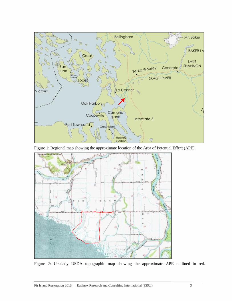
Figure 1: Regional map showing the approximate location of the Area of Potential Effect (APE).
Figure 2: Utsalady USDA topographic map showing the approximate APE outlined in red.
Fir Island Restoration 2013 Equinox Research and Consulting International (ERCI) 4
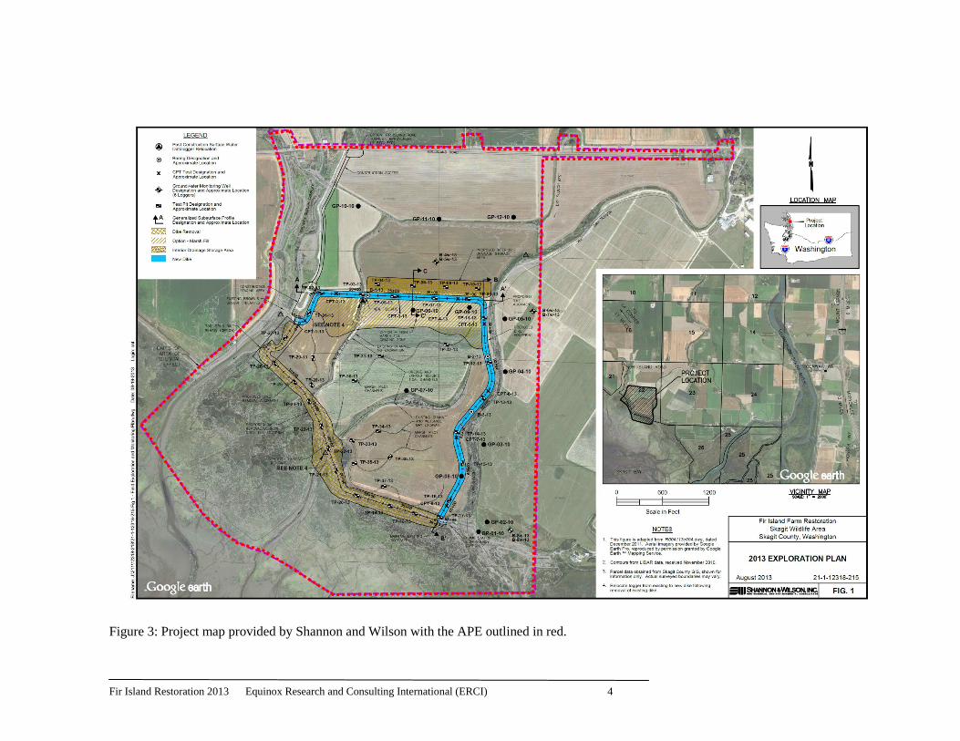
Figure 3: Project map provided by Shannon and Wilson with the APE outlined in red.
Fir Island Restoration 2013 Equinox Research and Consulting International (ERCI) 5
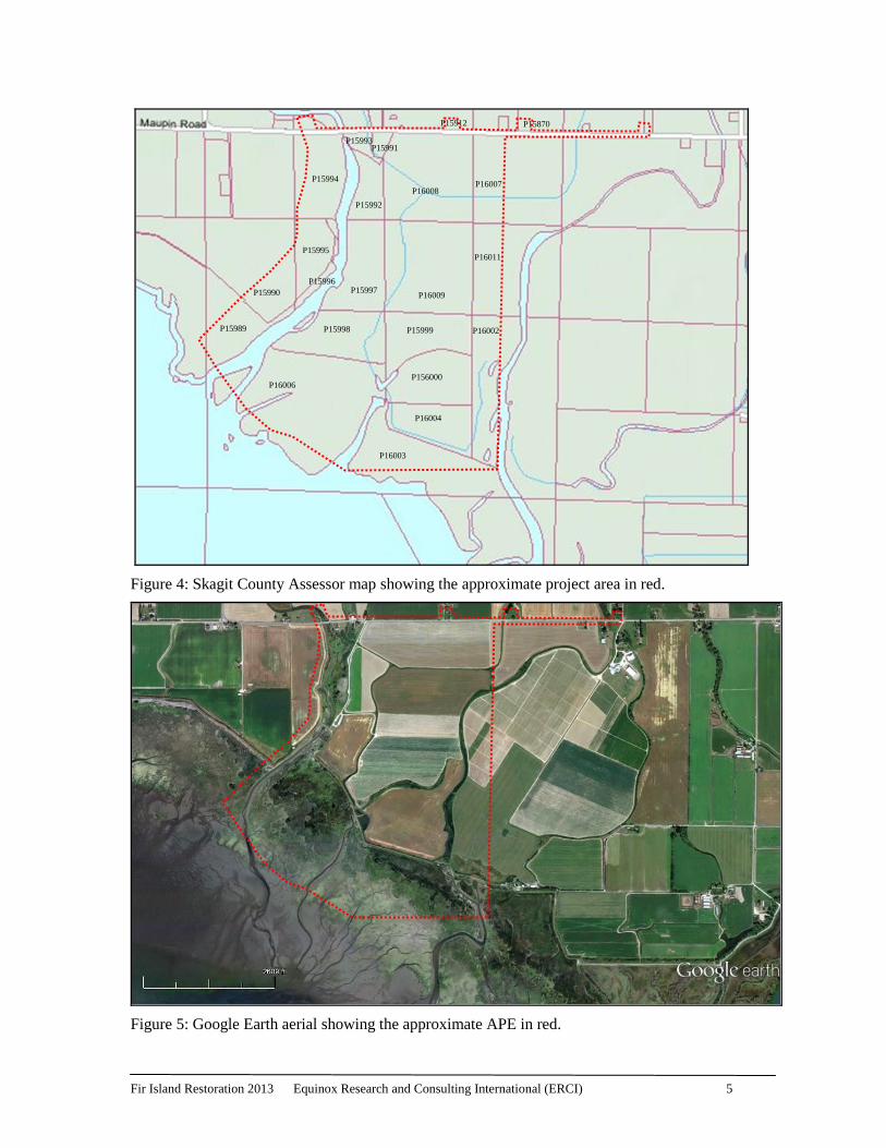
Figure 4: Skagit County Assessor map showing the approximate project area in red.
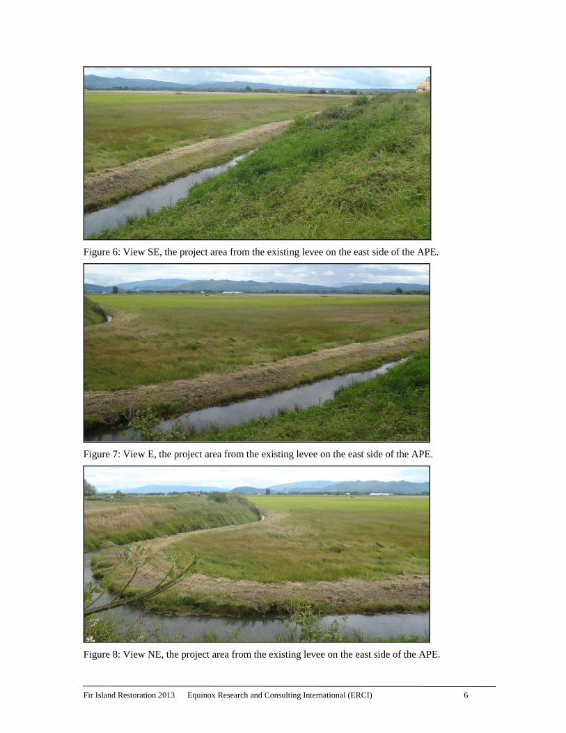
Figure 5: Google Earth aerial showing the approximate APE in red.
P16006
P15998
P16003
P15999
P16004
P16009
P16011
P16002
P15997
P15992
P16008 P16007
P15993 P15991
P15912 P15870
P156000
P15989
P15990
P15995
P15996
P15994
Fir Island Restoration 2013 Equinox Research and Consulting International (ERCI) 6
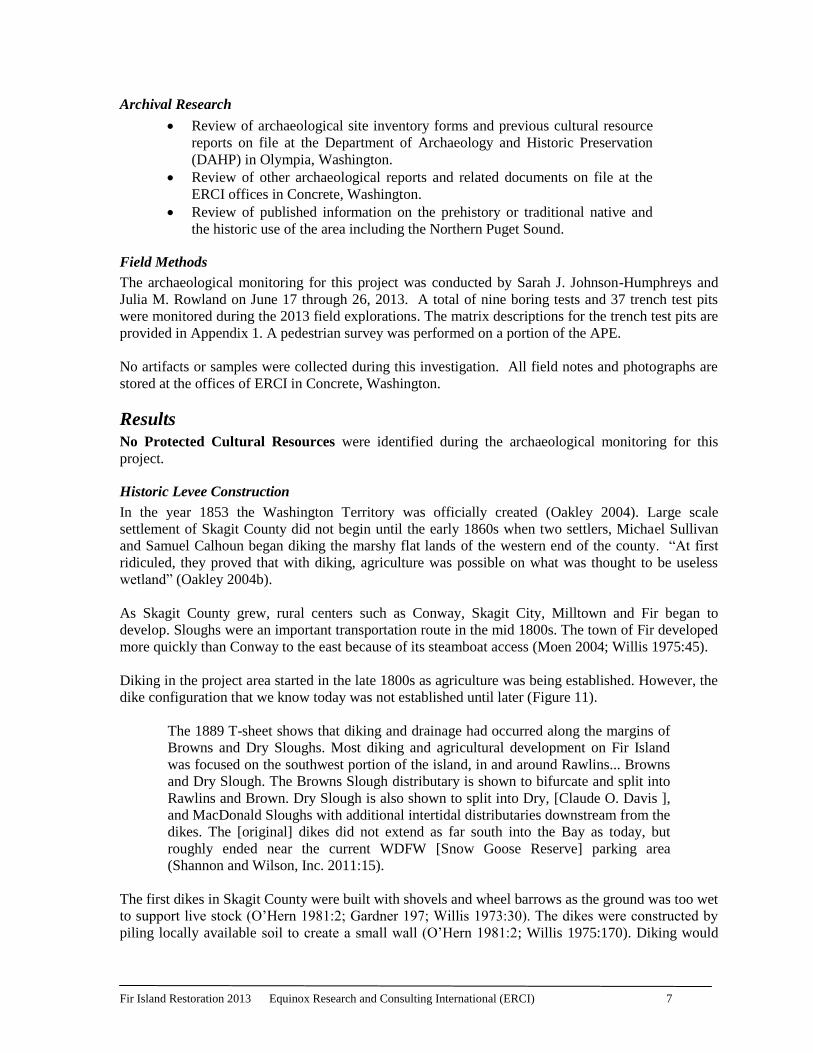
Figure 6: View SE, the project area from the existing levee on the east side of the APE.
Figure 7: View E, the project area from the existing levee on the east side of the APE.
Figure 8: View NE, the project area from the existing levee on the east side of the APE.
Fir Island Restoration 2013 Equinox Research and Consulting International (ERCI) 7
Archival Research
Review of archaeological site inventory forms and previous cultural resource
reports on file at the Department of Archaeology and Historic Preservation
(DAHP) in Olympia, Washington.
Review of other archaeological reports and related documents on file at the
ERCI offices in Concrete, Washington.
Review of published information on the prehistory or traditional native and
the historic use of the area including the Northern Puget Sound.
Field Methods
The archaeological monitoring for this project was conducted by Sarah J. Johnson-Humphreys and
Julia M. Rowland on June 17 through 26, 2013. A total of nine boring tests and 37 trench test pits
were monitored during the 2013 field explorations. The matrix descriptions for the trench test pits are
provided in Appendix 1. A pedestrian survey was performed on a portion of the APE.
No artifacts or samples were collected during this investigation. All field notes and photographs are
stored at the offices of ERCI in Concrete, Washington.
Results
No Protected Cultural Resources were identified during the archaeological monitoring for this
project.
Historic Levee Construction
In the year 1853 the Washington Territory was officially created (Oakley 2004). Large scale
settlement of Skagit County did not begin until the early 1860s when two settlers, Michael Sullivan
and Samuel Calhoun began diking the marshy flat lands of the western end of the county. “At first
ridiculed, they proved that with diking, agriculture was possible on what was thought to be useless
wetland” (Oakley 2004b).
As Skagit County grew, rural centers such as Conway, Skagit City, Milltown and Fir began to
develop. Sloughs were an important transportation route in the mid 1800s. The town of Fir developed
more quickly than Conway to the east because of its steamboat access (Moen 2004; Willis 1975:45).
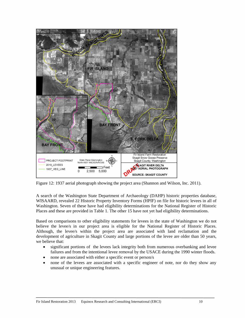
Diking in the project area started in the late 1800s as agriculture was being established. However, the
dike configuration that we know today was not established until later (Figure 11).
The 1889 T-sheet shows that diking and drainage had occurred along the margins of
Browns and Dry Sloughs. Most diking and agricultural development on Fir Island
was focused on the southwest portion of the island, in and around Rawlins... Browns
and Dry Slough. The Browns Slough distributary is shown to bifurcate and split into
Rawlins and Brown. Dry Slough is also shown to split into Dry, [Claude O. Davis ],
and MacDonald Sloughs with additional intertidal distributaries downstream from the
dikes. The [original] dikes did not extend as far south into the Bay as today, but
roughly ended near the current WDFW [Snow Goose Reserve] parking area
(Shannon and Wilson, Inc. 2011:15).
The first dikes in Skagit County were built with shovels and wheel barrows as the ground was too wet
to support live stock (O’Hern 1981:2; Gardner 197; Willis 1973:30). The dikes were constructed by
piling locally available soil to create a small wall (O’Hern 1981:2; Willis 1975:170). Diking would
Fir Island Restoration 2013 Equinox Research and Consulting International (ERCI) 8
create a borrow ditch on the inside of the dike that would also function as a drainage ditch. Sluice
boxes were often placed in these ditches. These sluice boxes were the first tide gates allowing water
to drain out of the ditches when the tide was low but not allowing the tide to come into the ditches
(O’Hern 1981:2). Early dikes were on average four feet tall and eight feet wide across the bottom
tapering to two and a half feet wide at the top (Willis 1973:30). As diking continued in the valley and
the land grew drier, farmers were able to use horses to assist them in dike building. The horses were
harnessed with a slip scraper, a sort of bucket that drug behind the horse collecting dirt (O’Hern
1981:5). In 1915 people began using imported rocks for reinforcement in the dikes (O’Hern 1981).
Rock was taken from quarries and carried on scows, a type of flat bottom boat or barge, to the areas
where dike erosion was particularly bad (Willis 1975).
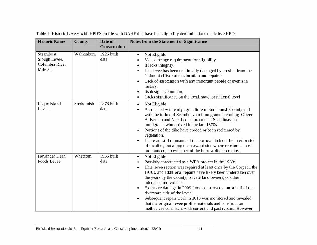
By 1937 the locations of the dikes in the project area were very similar to today (Figure 12). By this
time Fir Island Road had been built to cross both Brown and Dry Slough and the remainder of the
project area had been converted to farmland (Shannon and Wilson, Inc. 2011).
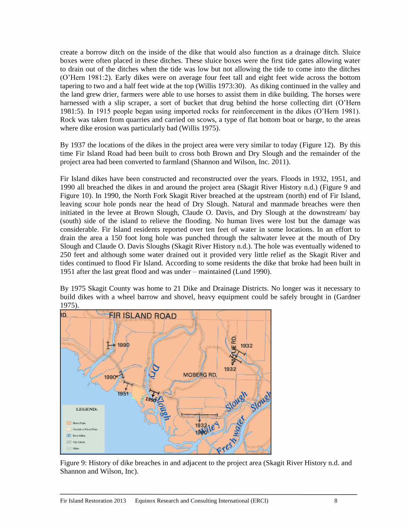
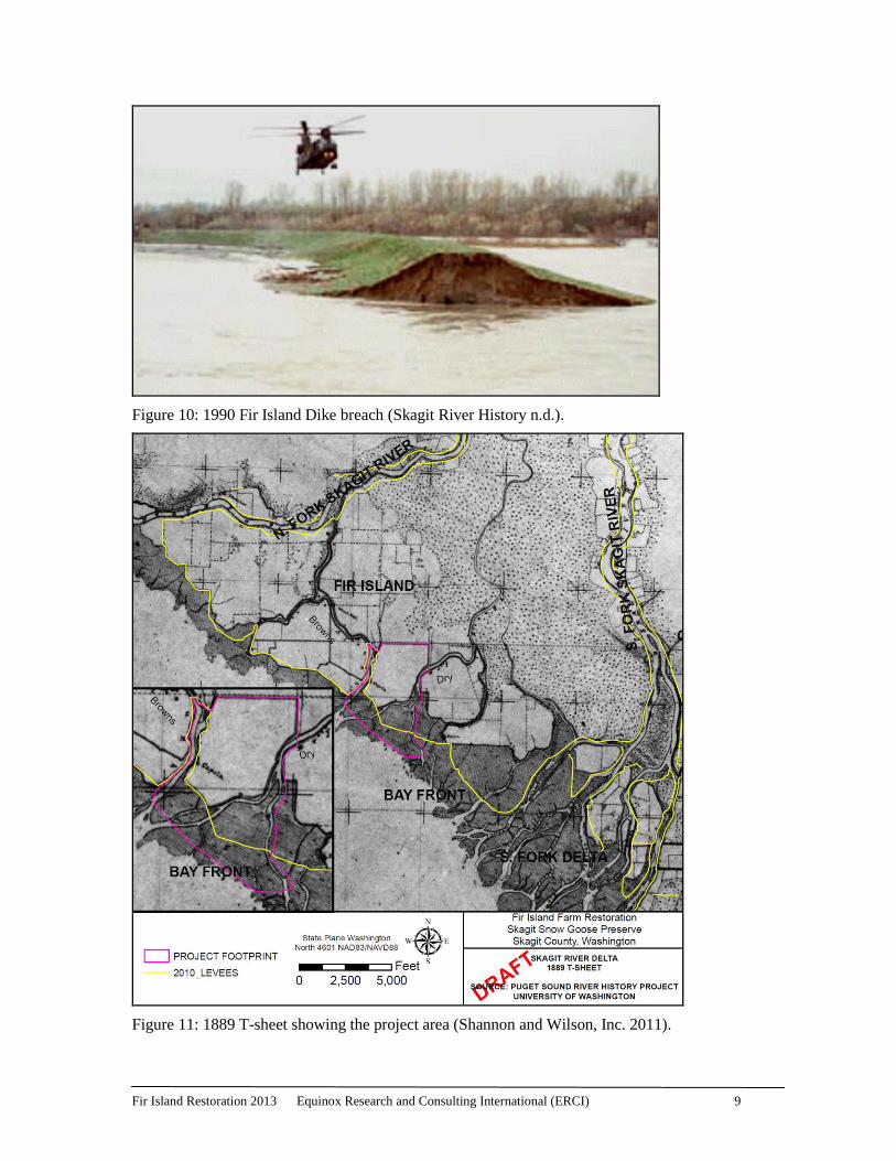
Fir Island dikes have been constructed and reconstructed over the years. Floods in 1932, 1951, and
1990 all breached the dikes in and around the project area (Skagit River History n.d.) (Figure 9 and
Figure 10). In 1990, the North Fork Skagit River breached at the upstream (north) end of Fir Island,
leaving scour hole ponds near the head of Dry Slough. Natural and manmade breaches were then
initiated in the levee at Brown Slough, Claude O. Davis, and Dry Slough at the downstream/ bay
(south) side of the island to relieve the flooding. No human lives were lost but the damage was
considerable. Fir Island residents reported over ten feet of water in some locations. In an effort to
drain the area a 150 foot long hole was punched through the saltwater levee at the mouth of Dry
Slough and Claude O. Davis Sloughs (Skagit River History n.d.). The hole was eventually widened to
250 feet and although some water drained out it provided very little relief as the Skagit River and
tides continued to flood Fir Island. According to some residents the dike that broke had been built in
1951 after the last great flood and was under – maintained (Lund 1990).
By 1975 Skagit County was home to 21 Dike and Drainage Districts. No longer was it necessary to
build dikes with a wheel barrow and shovel, heavy equipment could be safely brought in (Gardner
1975).
Figure 9: History of dike breaches in and adjacent to the project area (Skagit River History n.d. and
Shannon and Wilson, Inc).
Fir Island Restoration 2013 Equinox Research and Consulting International (ERCI) 9
Figure 10: 1990 Fir Island Dike breach (Skagit River History n.d.).
Figure 11: 1889 T-sheet showing the project area (Shannon and Wilson, Inc. 2011).
Fir Island Restoration 2013 Equinox Research and Consulting International (ERCI) 10
Figure 12: 1937 aerial photograph showing the project area (Shannon and Wilson, Inc. 2011).
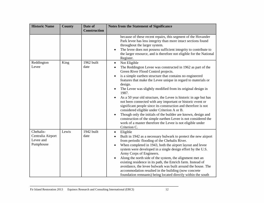
A search of the Washington State Department of Archaeology (DAHP) historic properties database,
WISAARD, revealed 22 Historic Property Inventory Forms (HPIF) on file for historic levees in all of
Washington. Seven of these have had eligibility determinations for the National Register of Historic
Places and these are provided in Table 1. The other 15 have not yet had eligibility determinations.
Based on comparisons to other eligibility statements for levees in the state of Washington we do not
believe the levee/s in our project area is eligible for the National Register of Historic Places.
Although, the levee/s within the project area are associated with land reclamation and the
development of agriculture in Skagit County and large portions of the levee are older than 50 years,
we believe that:
significant portions of the levees lack integrity both from numerous overbanking and levee
failures and from the intentional levee removal by the USACE during the 1990 winter floods.
none are associated with either a specific event or person/s
none of the levees are associated with a specific engineer of note, nor do they show any
unusual or unique engineering features.
Fir Island Restoration 2013 Equinox Research and Consulting International (ERCI) 11
Table 1: Historic Levees with HPIFS on file with DAHP that have had eligibility determinations made by SHPO.
Historic Name County Date of
Construction
Notes from the Statement of Significance
Steamboat
Slough Levee,
Columbia River
Mile 35
Wahkiakum 1926 built
date Not Eligible
Meets the age requirement for eligibility.
It lacks integrity.
The levee has been continually damaged by erosion from the
Columbia River at this location and repaired.
Lack of association with any important people or events in
history.
Its design is common.
Lacks significance on the local, state, or national level
Leque Island
Levee
Snohomish 1878 built
date Not Eligible
Associated with early agriculture in Snohomish County and
with the influx of Scandinavian immigrants including Oliver
B. Iverson and Nels Leque, prominent Scandinavian
immigrants who arrived in the late 1870s.
Portions of the dike have eroded or been reclaimed by
vegetation.
There are still remnants of the borrow ditch on the interior side
of the dike, but along the seaward side where erosion is most
pronounced, no evidence of the borrow ditch remains.
Hovander Dean
Foods Levee
Whatcom 1935 built
date Not Eligible
Possibly constructed as a WPA project in the 1930s.
This levee section was repaired at least once by the Corps in the
1970s, and additional repairs have likely been undertaken over
the years by the County, private land owners, or other
interested individuals.
Extensive damage in 2009 floods destroyed almost half of the
riverward side of the levee.
Subsequent repair work in 2010 was monitored and revealed
that the original levee profile materials and construction
method are consistent with current and past repairs. However,
Fir Island Restoration 2013 Equinox Research and Consulting International (ERCI) 12
Historic Name County Date of
Construction
Notes from the Statement of Significance
because of these recent repairs, this segment of the Hovander
Park levee has less integrity than more intact sections found
throughout the larger system.
The levee does not possess sufficient integrity to contribute to
the larger resource, and is therefore not eligible for the National
Register.
Reddington
Levee
King 1962 built
date Not Eligible
The Reddington Levee was constructed in 1962 as part of the
Green River Flood Control projects.
is a simple earthen structure that contains no engineered
features that make the Levee unique in regard to materials or
design.
The Levee was slightly modified from its original design in
1987.
As a 50 year old structure, the Levee is historic in age but has
not been connected with any important or historic event or
significant people since its construction and therefore is not
considered eligible under Criterion A or B.
Though only the initials of the builder are known, design and
construction of the simple earthen Levee is not considered the
work of a master therefore the Levee is not eligible under
Criterion C.
Chehalis-
Centralia Airport
Levee and
Pumphouse
Lewis 1942 built
date Eligible
Built in 1942 as a necessary bulwark to protect the new airport
from periodic flooding of the Chehalis River.
When completed in 1943, both the airport layout and levee
system were developed in a single design effort by the U.S.
Army Corps of Engineers.
Along the north side of the system, the alignment met an
existing residence in its path, the Emrich farm. Instead of
avoidance, the levee bulwark was built around the house. The
accommodation resulted in the building (now concrete
foundation remnants) being located directly within the south
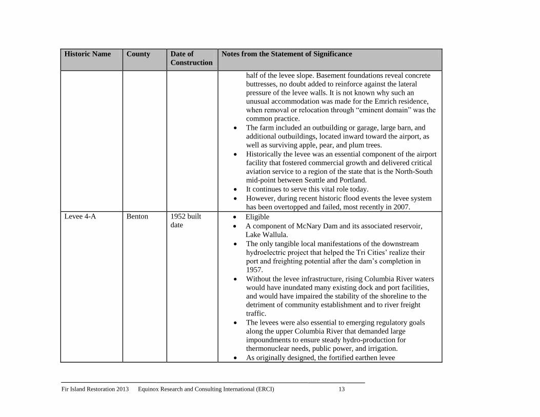
Fir Island Restoration 2013 Equinox Research and Consulting International (ERCI) 13
Historic Name County Date of
Construction
Notes from the Statement of Significance
half of the levee slope. Basement foundations reveal concrete
buttresses, no doubt added to reinforce against the lateral
pressure of the levee walls. It is not known why such an
unusual accommodation was made for the Emrich residence,
when removal or relocation through “eminent domain” was the
common practice.
The farm included an outbuilding or garage, large barn, and
additional outbuildings, located inward toward the airport, as
well as surviving apple, pear, and plum trees.
Historically the levee was an essential component of the airport
facility that fostered commercial growth and delivered critical
aviation service to a region of the state that is the North-South
mid-point between Seattle and Portland.
It continues to serve this vital role today.
However, during recent historic flood events the levee system
has been overtopped and failed, most recently in 2007.
Levee 4-A Benton 1952 built
date Eligible
A component of McNary Dam and its associated reservoir,
Lake Wallula.
The only tangible local manifestations of the downstream
hydroelectric project that helped the Tri Cities’ realize their
port and freighting potential after the dam’s completion in
1957.
Without the levee infrastructure, rising Columbia River waters
would have inundated many existing dock and port facilities,
and would have impaired the stability of the shoreline to the
detriment of community establishment and to river freight
traffic.
The levees were also essential to emerging regulatory goals
along the upper Columbia River that demanded large
impoundments to ensure steady hydro-production for
thermonuclear needs, public power, and irrigation.
As originally designed, the fortified earthen levee

Fir Island Restoration 2013 Equinox Research and Consulting International (ERCI) 14
Historic Name County Date of
Construction
Notes from the Statement of Significance
embankments had trapezoidal profiles, and were mostly devoid
of vegetation, and thereby projected artificiality.
retains its original structural qualities and visual characteristics
of height, profile, and appearance. It continues to evoke a
functional relationship to the river and to the adjacent
community it protects.
The naturalistic backdrop of Bateman Island further evokes the
period of significance, when most of the immediate landscape
was undeveloped and Richland was a young community
emerging from World War II.
Presently, the discontinuous intervening space between the Tri
Cities and McNary Dam is too great to justify the levees as
contributing elements of the dam district.
Still, as the only local physical manifestations of the dam’s
impact, and one of the consequential factors in the economic
health of the Tri Cities, individual levees are considered
potentially contributing properties in the proposed historic
district.
Richland Levee 4-A is therefore recommended eligible for
listing in the National Register of Historic Places (NRHP)
under Criterion A, for its critical relationship to Community
Planning and to the Economic Development of the Tri Cities
area.
The levee is also recommended eligible under criterion C for
internal structural properties as well as evocative external
characteristics that define its role in containing water and
enhancing port activities.
Levee 2-c Benton 1948 built
date Eligible
Richland Levee 2-C is recommended eligible for listing in the
National Register of Historic Places (NRHP) as a contributing
element to the historical significance of McNary Dam.
Levee 2-C is also recommended significant for its association
with the government-planned community created to serve

Fir Island Restoration 2013 Equinox Research and Consulting International (ERCI) 15
Historic Name County Date of
Construction
Notes from the Statement of Significance
personnel of the Hanford Engineer Work plant (1943-1944),
used for plutonium production for the Manhattan Project and
later the Cold War.
The pending McNary Dam nomination form recommends the
dam as significant under Criterion A for its impacts on the local
and regional economy, river freighting, the fledgling thermo-
nuclear industry, and post-World War II federal electrical
power management.
McNary Dam and its reservoir are also considered eligible
under Criterion C for embodying unique and distinctive
engineering characteristics.
Fir Island Restoration 2013 Equinox Research and Consulting International (ERCI) 16
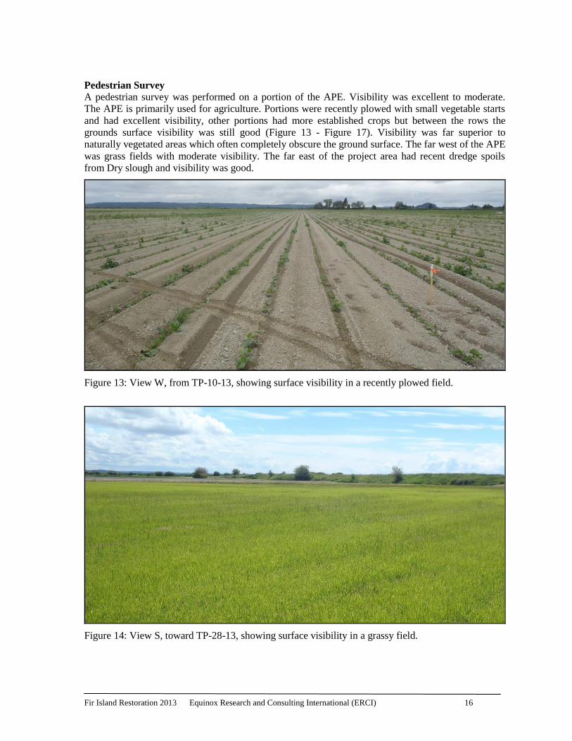
Pedestrian Survey
A pedestrian survey was performed on a portion of the APE. Visibility was excellent to moderate.
The APE is primarily used for agriculture. Portions were recently plowed with small vegetable starts
and had excellent visibility, other portions had more established crops but between the rows the
grounds surface visibility was still good (Figure 13 - Figure 17). Visibility was far superior to
naturally vegetated areas which often completely obscure the ground surface. The far west of the APE
was grass fields with moderate visibility. The far east of the project area had recent dredge spoils
from Dry slough and visibility was good.
Figure 13: View W, from TP-10-13, showing surface visibility in a recently plowed field.
Figure 14: View S, toward TP-28-13, showing surface visibility in a grassy field.
Fir Island Restoration 2013 Equinox Research and Consulting International (ERCI) 17
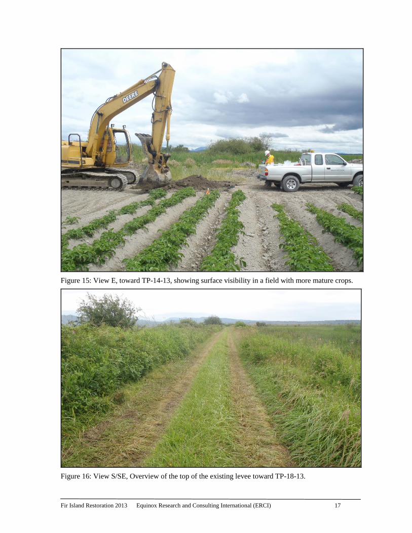
Figure 15: View E, toward TP-14-13, showing surface visibility in a field with more mature crops.
Figure 16: View S/SE, Overview of the top of the existing levee toward TP-18-13.
Fir Island Restoration 2013 Equinox Research and Consulting International (ERCI) 18
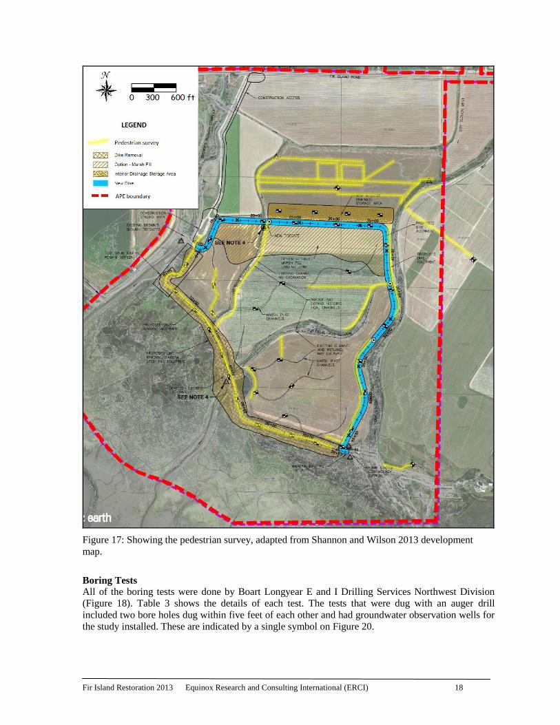
Figure 17: Showing the pedestrian survey, adapted from Shannon and Wilson 2013 development
map.
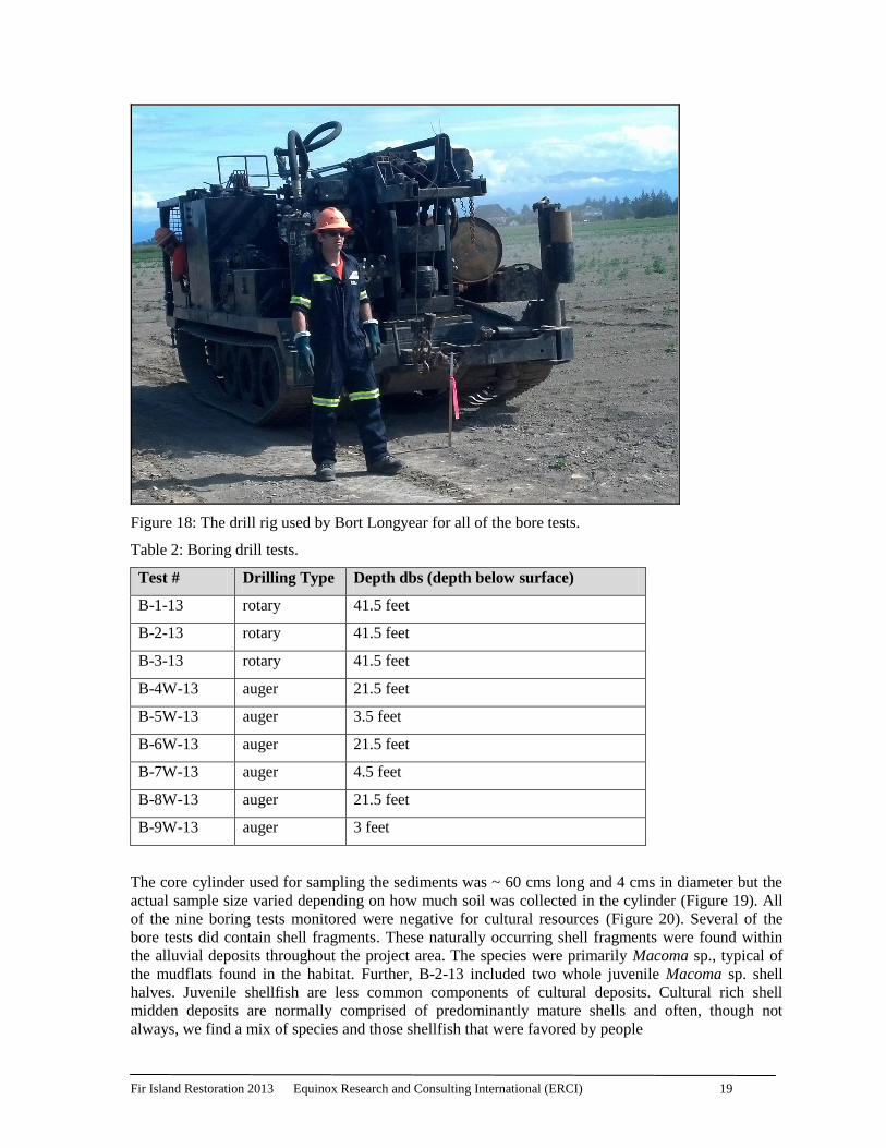
Boring Tests
All of the boring tests were done by Boart Longyear E and I Drilling Services Northwest Division
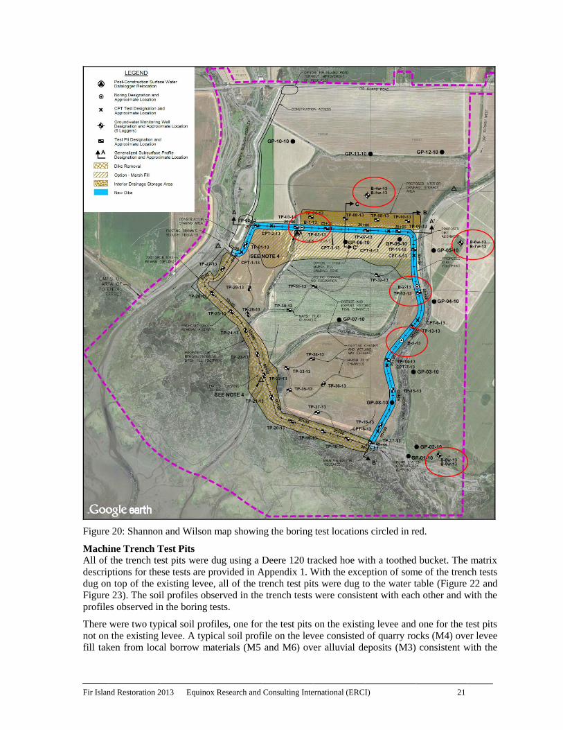
(Figure 18). Table 3 shows the details of each test. The tests that were dug with an auger drill
included two bore holes dug within five feet of each other and had groundwater observation wells for
the study installed. These are indicated by a single symbol on Figure 20.
Fir Island Restoration 2013 Equinox Research and Consulting International (ERCI) 19
Figure 18: The drill rig used by Bort Longyear for all of the bore tests.
Table 2: Boring drill tests.
Test # Drilling Type Depth dbs (depth below surface)
B-1-13 rotary 41.5 feet
B-2-13 rotary 41.5 feet
B-3-13 rotary 41.5 feet
B-4W-13 auger 21.5 feet
B-5W-13 auger 3.5 feet
B-6W-13 auger 21.5 feet
B-7W-13 auger 4.5 feet
B-8W-13 auger 21.5 feet
B-9W-13 auger 3 feet
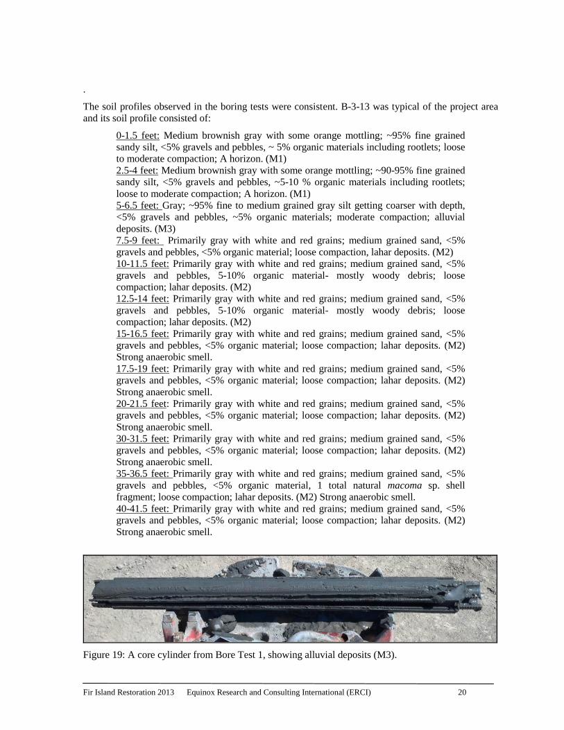
The core cylinder used for sampling the sediments was ~ 60 cms long and 4 cms in diameter but the
actual sample size varied depending on how much soil was collected in the cylinder (Figure 19). All
of the nine boring tests monitored were negative for cultural resources (Figure 20). Several of the
bore tests did contain shell fragments. These naturally occurring shell fragments were found within
the alluvial deposits throughout the project area. The species were primarily Macoma sp., typical of
the mudflats found in the habitat. Further, B-2-13 included two whole juvenile Macoma sp. shell
halves. Juvenile shellfish are less common components of cultural deposits. Cultural rich shell
midden deposits are normally comprised of predominantly mature shells and often, though not
always, we find a mix of species and those shellfish that were favored by people
Fir Island Restoration 2013 Equinox Research and Consulting International (ERCI) 20
.
The soil profiles observed in the boring tests were consistent. B-3-13 was typical of the project area
and its soil profile consisted of:
0-1.5 feet: Medium brownish gray with some orange mottling; ~95% fine grained
sandy silt, <5% gravels and pebbles, ~ 5% organic materials including rootlets; loose
to moderate compaction; A horizon. (M1)
2.5-4 feet: Medium brownish gray with some orange mottling; ~90-95% fine grained
sandy silt, <5% gravels and pebbles, ~5-10 % organic materials including rootlets;
loose to moderate compaction; A horizon. (M1)
5-6.5 feet: Gray; ~95% fine to medium grained gray silt getting coarser with depth,
<5% gravels and pebbles, ~5% organic materials; moderate compaction; alluvial
deposits. (M3)
7.5-9 feet: Primarily gray with white and red grains; medium grained sand, <5%
gravels and pebbles, <5% organic material; loose compaction, lahar deposits. (M2)
10-11.5 feet: Primarily gray with white and red grains; medium grained sand, <5%
gravels and pebbles, 5-10% organic material- mostly woody debris; loose
compaction; lahar deposits. (M2)
12.5-14 feet: Primarily gray with white and red grains; medium grained sand, <5%
gravels and pebbles, 5-10% organic material- mostly woody debris; loose
compaction; lahar deposits. (M2)
15-16.5 feet: Primarily gray with white and red grains; medium grained sand, <5%
gravels and pebbles, <5% organic material; loose compaction; lahar deposits. (M2)
Strong anaerobic smell.
17.5-19 feet: Primarily gray with white and red grains; medium grained sand, <5%
gravels and pebbles, <5% organic material; loose compaction; lahar deposits. (M2)
Strong anaerobic smell.
20-21.5 feet: Primarily gray with white and red grains; medium grained sand, <5%
gravels and pebbles, <5% organic material; loose compaction; lahar deposits. (M2)
Strong anaerobic smell.
30-31.5 feet: Primarily gray with white and red grains; medium grained sand, <5%
gravels and pebbles, <5% organic material; loose compaction; lahar deposits. (M2)
Strong anaerobic smell.
35-36.5 feet: Primarily gray with white and red grains; medium grained sand, <5%
gravels and pebbles, <5% organic material, 1 total natural macoma sp. shell
fragment; loose compaction; lahar deposits. (M2) Strong anaerobic smell.
40-41.5 feet: Primarily gray with white and red grains; medium grained sand, <5%
gravels and pebbles, <5% organic material; loose compaction; lahar deposits. (M2)
Strong anaerobic smell.
Figure 19: A core cylinder from Bore Test 1, showing alluvial deposits (M3).
Fir Island Restoration 2013 Equinox Research and Consulting International (ERCI) 21
Figure 20: Shannon and Wilson map showing the boring test locations circled in red.
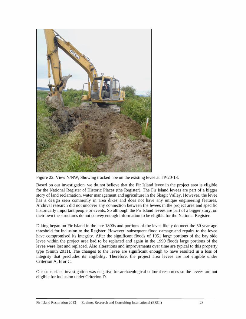
Machine Trench Test Pits
All of the trench test pits were dug using a Deere 120 tracked hoe with a toothed bucket. The matrix
descriptions for these tests are provided in Appendix 1. With the exception of some of the trench tests
dug on top of the existing levee, all of the trench test pits were dug to the water table (Figure 22 and
Figure 23). The soil profiles observed in the trench tests were consistent with each other and with the
profiles observed in the boring tests.
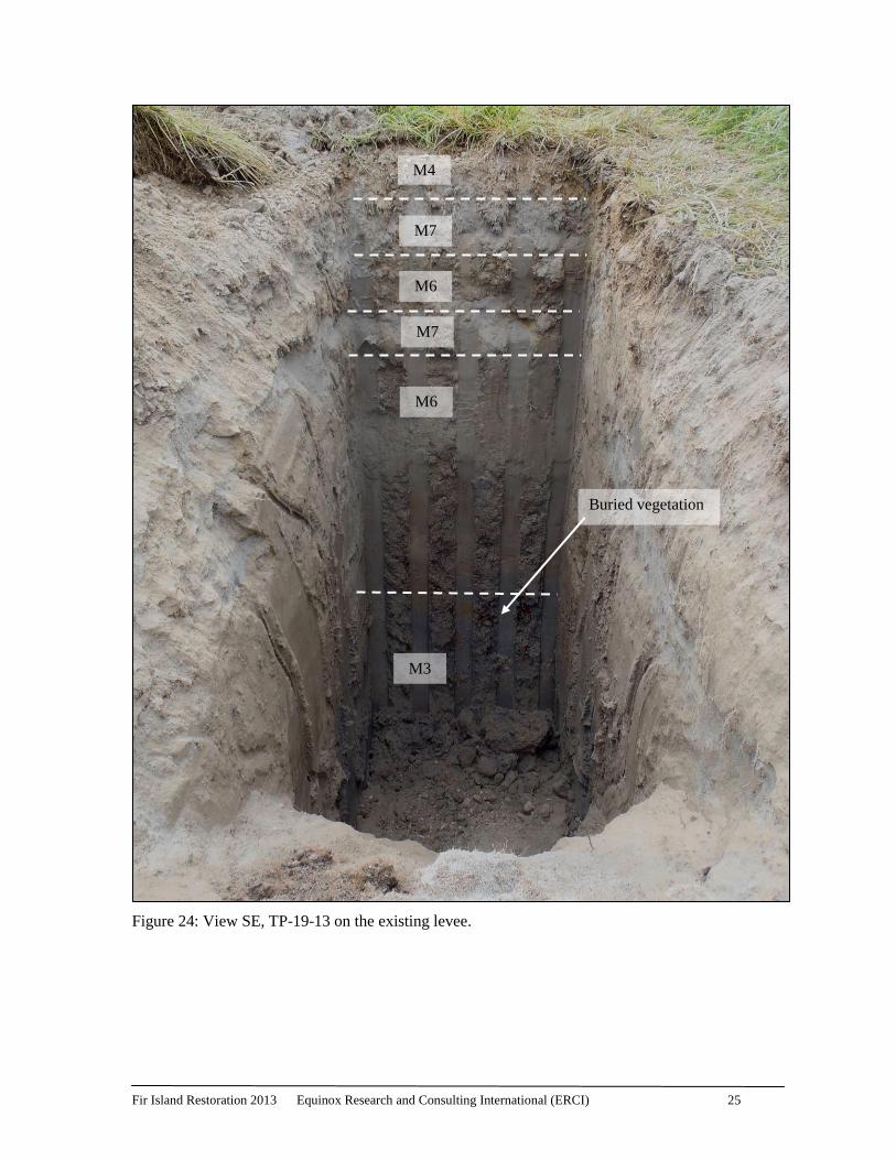
There were two typical soil profiles, one for the test pits on the existing levee and one for the test pits
not on the existing levee. A typical soil profile on the levee consisted of quarry rocks (M4) over levee
fill taken from local borrow materials (M5 and M6) over alluvial deposits (M3) consistent with the
Fir Island Restoration 2013 Equinox Research and Consulting International (ERCI) 22
alluvial deposits seen elsewhere in the project area. Buried vegetation often existed between the levee
fill and the alluvial deposits. Historically levees were built by hand and local borrow was used and
placed on the existing surface in an area, sometimes without removing the vegetation. The profile
observed was consistent with this pattern. In a couple of places on the levee there was more recent
dredge fill that had been added to the levee as part of flood repairs (M6) (Figure 24). Outside of the
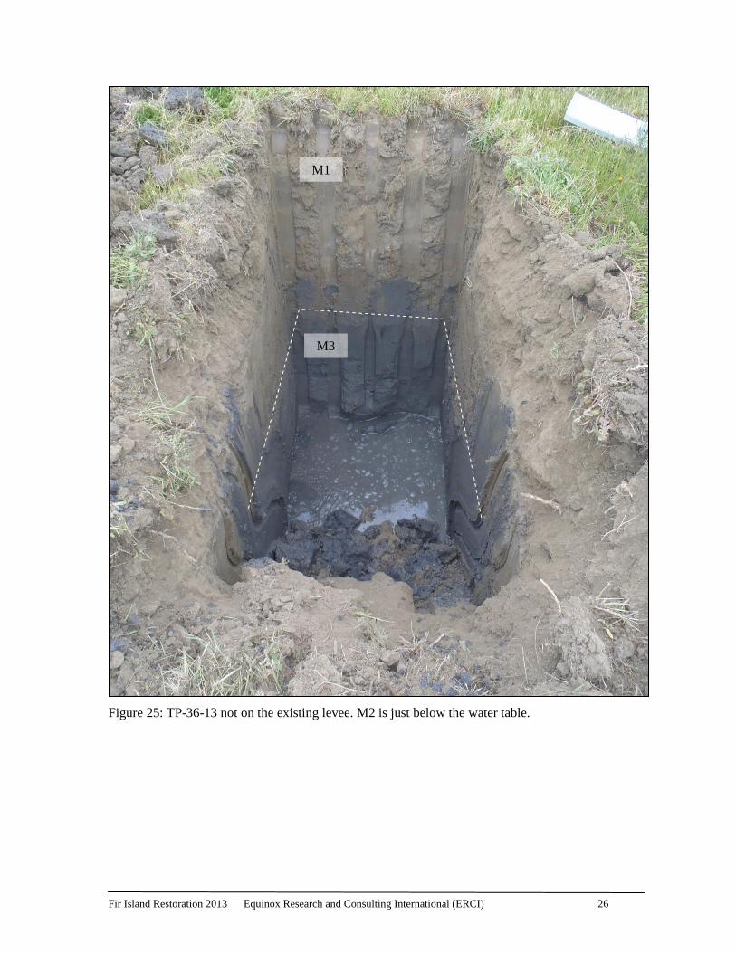
existing levee a typical soil profile consisted of a medium gray brown fine grained sandy silt surface
layer, the A horizon, (M1) over alluvial deposits (M3) over lahar deposits (M2) (Figure 25).
In all of the machine trench test pits either M2 or M3 was reached. In many of these tests these
sediments were interpreted as the intact native soil. Given the variable nature of the historic marsh
habitat and the history of using native material as fill, in some tests it was difficult to determine if the
M3 was in fact intact or whether it was native soil that had been used as fill in that location. In
particular, TP-21-13, TP-22-13 and TP-23-13 are within or adjacent to the 1990 flood levee repair
zone. In 1990 the existing levee in the southern portion of the project area along the Skagit Bay was
damaged by flood. There was significant erosion and scouring of the levee and areas around and
below the levee in this area. So while M3 was seen in the bottom of each of these test trenches it is
difficult to say if the M3 was intact or disturbed.
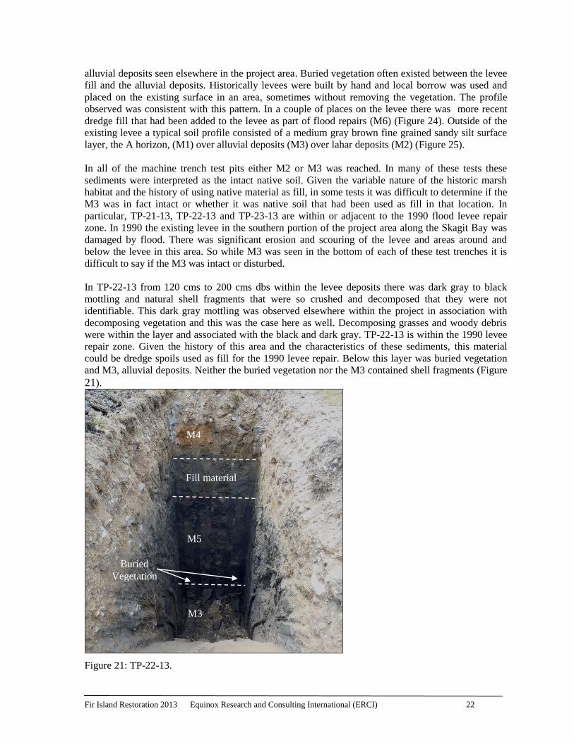
In TP-22-13 from 120 cms to 200 cms dbs within the levee deposits there was dark gray to black
mottling and natural shell fragments that were so crushed and decomposed that they were not
identifiable. This dark gray mottling was observed elsewhere within the project in association with
decomposing vegetation and this was the case here as well. Decomposing grasses and woody debris
were within the layer and associated with the black and dark gray. TP-22-13 is within the 1990 levee
repair zone. Given the history of this area and the characteristics of these sediments, this material
could be dredge spoils used as fill for the 1990 levee repair. Below this layer was buried vegetation
and M3, alluvial deposits. Neither the buried vegetation nor the M3 contained shell fragments (Figure 21).
Figure 21: TP-22-13.
M4
Fill material
Buried
Vegetation
M3
M5
Fir Island Restoration 2013 Equinox Research and Consulting International (ERCI) 23
Figure 22: View N/NW, Showing tracked hoe on the existing levee at TP-20-13.
Based on our investigation, we do not believe that the Fir Island levee in the project area is eligible
for the National Register of Historic Places (the Register). The Fir Island levees are part of a bigger
story of land reclamation, water management and agriculture in the Skagit Valley. However, the levee
has a design seen commonly in area dikes and does not have any unique engineering features.
Archival research did not uncover any connection between the levees in the project area and specific
historically important people or events. So although the Fir Island levees are part of a bigger story, on
their own the structures do not convey enough information to be eligible for the National Register.
Diking began on Fir Island in the late 1800s and portions of the levee likely do meet the 50 year age
threshold for inclusion to the Register. However, subsequent flood damage and repairs to the levee
have compromised its integrity. After the significant floods of 1951 large portions of the bay side
levee within the project area had to be replaced and again in the 1990 floods large portions of the
levee were lost and replaced. Also alterations and improvements over time are typical to this property
type (Smith 2011). The changes to the levee are significant enough to have resulted in a loss of
integrity that precludes its eligibility. Therefore, the project area levees are not eligible under
Criterion A, B or C.
Our subsurface investigation was negative for archaeological cultural resources so the levees are not
eligible for inclusion under Criterion D.
Fir Island Restoration 2013 Equinox Research and Consulting International (ERCI) 24
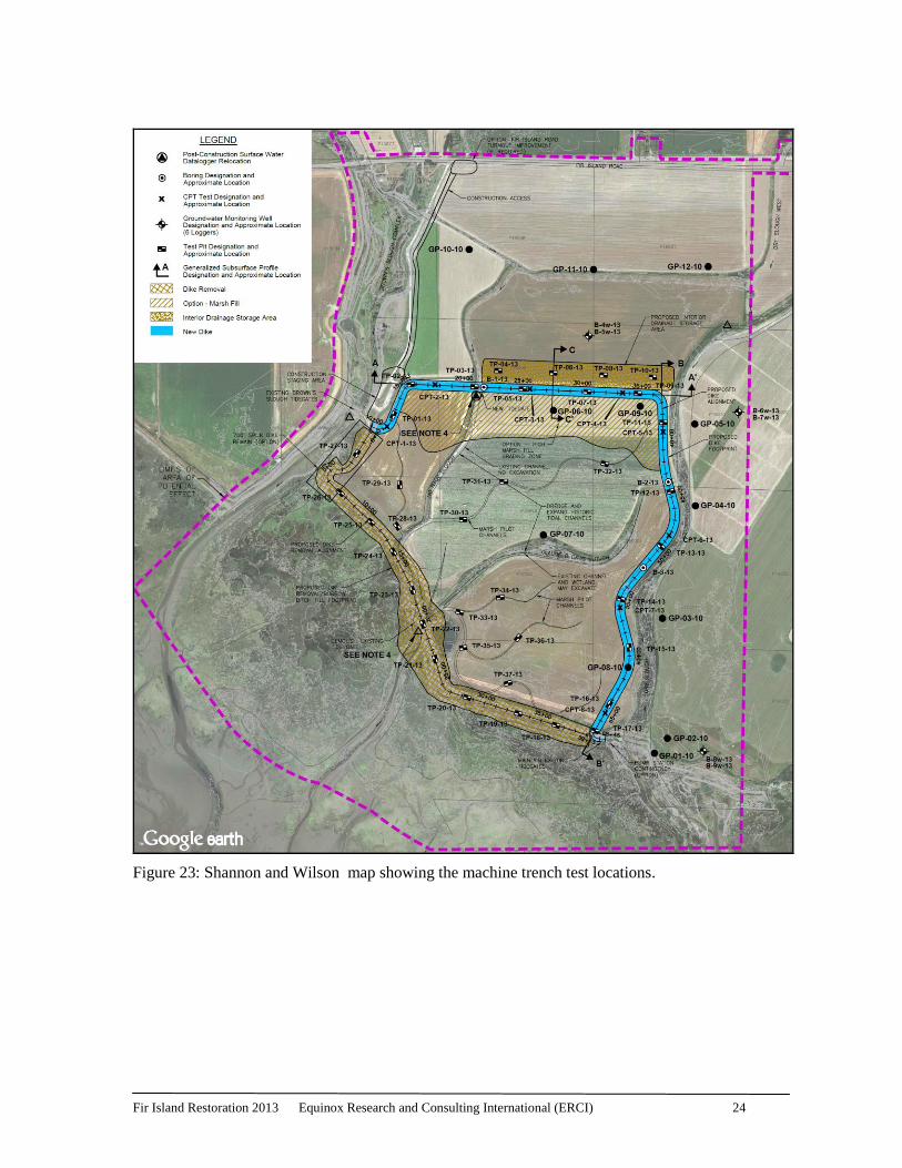
Figure 23: Shannon and Wilson map showing the machine trench test locations.
Fir Island Restoration 2013 Equinox Research and Consulting International (ERCI) 25
Figure 24: View SE, TP-19-13 on the existing levee.
M4
M7
M6
M3
Buried vegetation
M7
M6
Fir Island Restoration 2013 Equinox Research and Consulting International (ERCI) 26
Figure 25: TP-36-13 not on the existing levee. M2 is just below the water table.
M1
M3
Fir Island Restoration 2013 Equinox Research and Consulting International (ERCI) 27
No Historic Properties were encountered during this investigation. The management
recommendations that we are now providing are based on this field investigation. We recommend
that:
1. This project proceed as planned with a copy of the attached Unanticipated Discoveries
Protocol (UDP) on site at all times and a brief onsite training provided by a professional
archaeological to the Construction Crew prior to initiating this project
2. In the event that any ground-disturbing activities uncover protected cultural material (e.g.,
bones, shell, stone or antler tools), all work in the immediate vicinity should stop, the area
should be secured, and any equipment moved to a safe distance away from the location. The
protocol outlined in the Unanticipated Discoveries Protocol (UDP) (Appendix 2) should be
followed.
3. In the case of an unanticipated discovery of human remains, the contractor and project
manager will cease excavation; secure the area and call the Skagit County Sherriff’s
department who will contact the Coroner to determine if the remains are forensic in nature
and if not then the Coroner will coordinate with the State Physical Anthropologist who will
then be responsible for their management.
Thank you for the opportunity to provide cultural resource management services for this project.
Regards,
Kelly R. Bush
Equinox Research and Consulting International Inc. (ERCI)
Fir Island Restoration 2013 Equinox Research and Consulting International (ERCI) 28
References Cited
Gardner, Nick
1975 Article: For Dike Officer Public Life was Satisfying. Skagit Valley Herald 23 January,
Mount Vernon, Washington.
Lund, Rick
1990 Fir Island in Danger of Becoming Part of Bay – Flood Water Coming in Faster than its
Receding. The Seattle Times.
Moen, Mamie Johnson
2004 Memories of Fir Island. www. Stumpranchonline.com. Available online at:
http://www.stumpranchonline.com/skagitjournal/WestCounty/MV-SW/Pre-1900/Fir02-
Moen.html. [Accessed January 2011]
Oakley, Janet
2004 Skagit County-Thumbnail History. Historylink.org. Available online at
http://www.historylink.org/index.cfm?DisplayPage=output.cfm&file_id=5663/ accessed
[April 2010].
O’Hern, Carol
1981 Diking in the Skagit Valley: The Skagit Settlers 1863-1920. Unpublished Master’s Thesis
submitted to the University of Washington. On file at the Skagit County Historical
Museum.
Shannon and Wilson, Inc.
2011 Technical Memorandum 1.1.2- Geomorphic Characterization Fir Island Farm, Snow
Goose Reserve Restoration Feasibility Study Fir Island, Washington. Submitted to
Washington Department of Fish and Wildlife, LaConner, Washington. On file at the
offices of Shannon and Wilson, Inc, Seattle, Washington.
Skagit River History
n.d. Photo Gallery. Electronic document,
http://www.skagitriverhistory.com/Photo_Gallery.htm, accessed August 2013.
Smart, Tamela and Alyson Rollins
2010 Archaeological Monitoring of Geoprobe Testing Report: Fir Island Farm Restoration
Feasibility Study, Skagit County, Washington.
Smith, Nick
2011 Deepwater Sough Levee HPIF. On file with Washington State DAHP, Olympia, WA.
Willis, Margaret
1973 Chechacos All – The Pioneering of the Skagit. Skagit County Historical Society, Mount
Vernon, Washington.
1975 Skagit Settlers: Trials and Triumphs, 1890-1920. Skagit County Historical Society,
Mount Vernon, Washington.
Fir Island Restoration 2013 Equinox Research and Consulting International (ERCI) 29
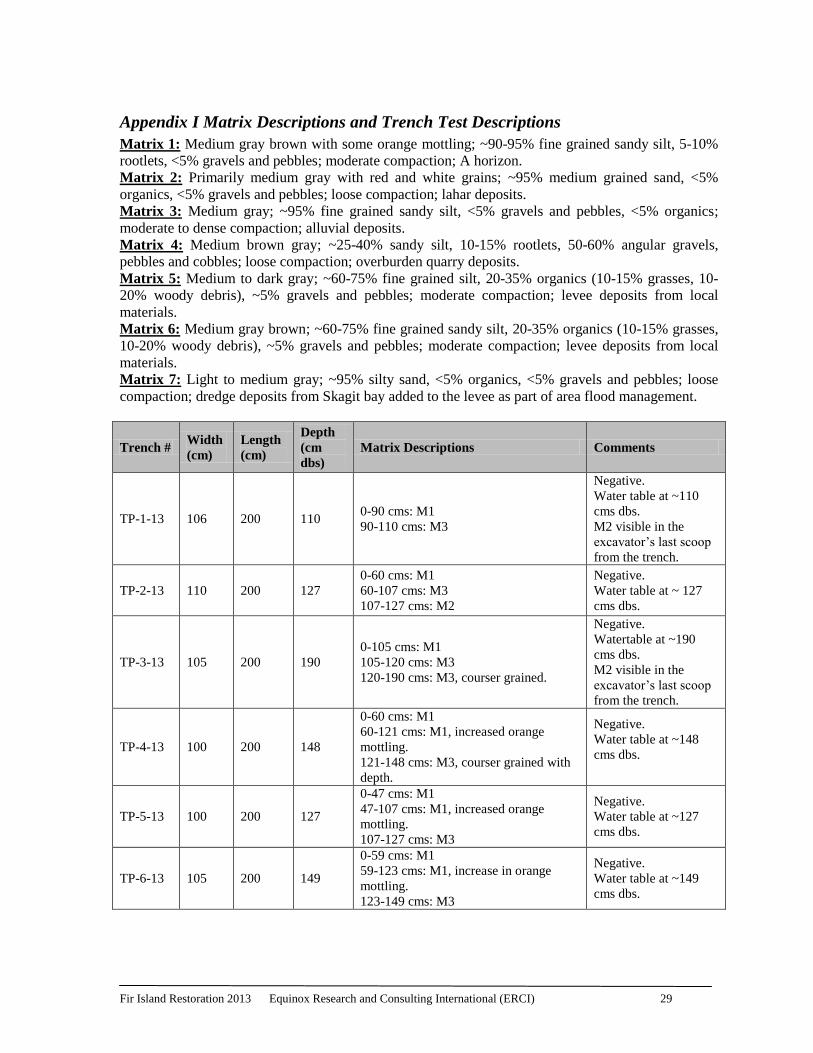
Appendix I Matrix Descriptions and Trench Test Descriptions
Matrix 1: Medium gray brown with some orange mottling; ~90-95% fine grained sandy silt, 5-10%
rootlets, <5% gravels and pebbles; moderate compaction; A horizon.
Matrix 2: Primarily medium gray with red and white grains; ~95% medium grained sand, <5%
organics, <5% gravels and pebbles; loose compaction; lahar deposits.
Matrix 3: Medium gray; ~95% fine grained sandy silt, <5% gravels and pebbles, <5% organics;
moderate to dense compaction; alluvial deposits.
Matrix 4: Medium brown gray; ~25-40% sandy silt, 10-15% rootlets, 50-60% angular gravels,
pebbles and cobbles; loose compaction; overburden quarry deposits.
Matrix 5: Medium to dark gray; ~60-75% fine grained silt, 20-35% organics (10-15% grasses, 10-
20% woody debris), ~5% gravels and pebbles; moderate compaction; levee deposits from local
materials.
Matrix 6: Medium gray brown; ~60-75% fine grained sandy silt, 20-35% organics (10-15% grasses,
10-20% woody debris), ~5% gravels and pebbles; moderate compaction; levee deposits from local
materials.
Matrix 7: Light to medium gray; ~95% silty sand, <5% organics, <5% gravels and pebbles; loose
compaction; dredge deposits from Skagit bay added to the levee as part of area flood management.
Trench # Width
(cm)
Length
(cm)
Depth
(cm
dbs)
Matrix Descriptions Comments
TP-1-13 106 200 110 0-90 cms: M1
90-110 cms: M3
Negative.
Water table at ~110
cms dbs.
M2 visible in the
excavator’s last scoop
from the trench.
TP-2-13 110 200 127
0-60 cms: M1
60-107 cms: M3
107-127 cms: M2
Negative.
Water table at ~ 127
cms dbs.
TP-3-13 105 200 190
0-105 cms: M1
105-120 cms: M3
120-190 cms: M3, courser grained.
Negative.
Watertable at ~190
cms dbs.
M2 visible in the
excavator’s last scoop
from the trench.
TP-4-13 100 200 148
0-60 cms: M1
60-121 cms: M1, increased orange
mottling.
121-148 cms: M3, courser grained with
depth.
Negative.
Water table at ~148
cms dbs.
TP-5-13 100 200 127
0-47 cms: M1
47-107 cms: M1, increased orange
mottling.
107-127 cms: M3
Negative.
Water table at ~127
cms dbs.
TP-6-13 105 200 149
0-59 cms: M1
59-123 cms: M1, increase in orange
mottling.
123-149 cms: M3
Negative.
Water table at ~149
cms dbs.
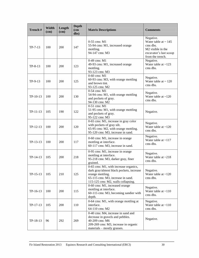
Fir Island Restoration 2013 Equinox Research and Consulting International (ERCI) 30
Trench # Width
(cm)
Length
(cm)
Depth
(cm
dbs)
Matrix Descriptions Comments
TP-7-13 100 200 147
0-55 cms: M1
55-94 cms: M1, increased orange
mottling.
94-147 cms: M3
Negative.
Water table at ~ 145
cms dbs.
M2 visible in the
excavator’s last scoop
from the trench.
TP-8-13 100 200 123
0-49 cms: M1
49-93 cms: M1, increased orange
mottling.
93-123 cms: M3
Negative.
Water table at ~123
cms dbs.
TP-9-13 100 200 125
0-60 cms: M1
60-93 cms: M3, with orange mottling
and brown tint.
93-125 cms: M2
Negative.
Water table at ~ 120
cms dbs.
TP-10-13 100 200 130
0-54 cms: M1
54-94 cms: M1, with orange mottling
and pockets of gray.
94-130 cms: M2
Negative.
Water table at ~120
cms dbs.
TP-11-13 105 190 122
0-51 cms: M1
51-95 cms: M1, with orange mottling
and pockets of gray.
95-122 cms: M3
Negative.
TP-12-13 100 200 120
0-65 cms: M1, increase in gray color
with pockets of gray silt.
65-95 cms: M2, with orange mottling.
95-120 cms: M3, increase in sand.
Negative.
Water table at ~120
cms dbs.
TP-13-13 100 200 117
0-60 cms: M1, increase in orange
mottling at interface.
60-117 cms: M3, increase in sand.
Negative.
Water table at ~117
cms dbs.
TP-14-13 105 200 218
0-95 cms: M1, increase in orange
mottling at interface.
95-218 cms: M3, darker gray, finer
grained.
Negative.
Water table at ~218
cms dbs.
TP-15-13 105 210 125
0-65 cms: M1, with increase organics,
dark gray/almost black pockets, increase
orange mottling.
65-115 cms: M3, increase in sand.
115-125 cms: M2, walls collapsing.
Negative.
Water table at ~120
cms dbs.
TP-16-13 100 200 115
0-60 cms: M1, increased orange
mottling at interface.
60-115 cms: M3, becoming sandier with
depth.
Negative.
Water table at ~110
cms dbs.
TP-17-13 105 200 110
0-64 cms: M1, with orange mottling at
interface.
64-110 cms: M2
Negative.
Water table at ~110
cms dbs.
TP-18-13 96 292 269
0-40 cms: M4, increase in sand and
decrease in gravels and pebbles.
40-209 cms: M6
209-269 cms: M3, increase in organic
materials – mostly grasses.
Negative.
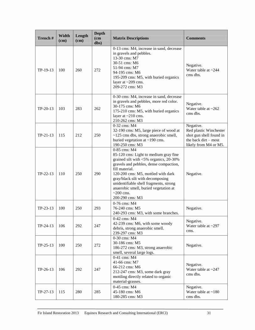
Fir Island Restoration 2013 Equinox Research and Consulting International (ERCI) 31
Trench # Width
(cm)
Length
(cm)
Depth
(cm
dbs)
Matrix Descriptions Comments
TP-19-13 100 260 272
0-13 cms: M4, increase in sand, decrease
in gravels and pebbles.
13-30 cms: M7
30-51 cms: M6
51-94 cms: M7
94-195 cms: M6
195-209 cms: M5, with buried organics
layer at ~209 cms.
209-272 cms: M3
Negative.
Water table at ~244
cms dbs.
TP-20-13 103 283 262
0-30 cms: M4, increase in sand, decrease
in gravels and pebbles, more red color.
30-175 cms: M6
175-210 cms: M5, with buried organics
layer at ~210 cms.
210-262 cms: M3
Negative.
Water table at ~262
cms dbs.
TP-21-13 115 212 250
0-32 cms: M4
32-190 cms: M5, large piece of wood at
~125 cms dbs, strong anaerobic smell,
buried vegetation at ~190 cms.
190-250 cms: M3
Negative.
Red plastic Winchester
shot gun shell found in
the back dirt – most
likely from M4 or M5.
TP-22-13 110 250 290
0-85 cms: M4
85-120 cms: Light to medium gray fine
grained silt with <5% organics, 20-30%
gravels and pebbles, dense compaction,
fill material.
120-200 cms: M5, mottled with dark
gray/black silt with decomposing
unidentifiable shell fragments, strong
anaerobic smell, buried vegetation at
~200 cms.
200-290 cms: M3
Negative.
TP-23-13 100 250 293
0-76 cms: M4
76-240 cms: M5
240-293 cms: M3, with some branches.
Negative.
TP-24-13 106 292 247
0-42 cms: M4
42-239 cms: M6, with some woody
debris, strong anaerobic smell.
239-297 cms: M3
Negative.
Water table at ~297
cms.
TP-25-13 100 250 272
0-30 cms: M4
30-186 cms: M5
186-272 cms: M3, strong anaerobic
smell, several large logs.
Negative.
TP-26-13 106 292 247
0-41 cms: M4
41-66 cms: M7
66-212 cms: M6
212-247 cms: M3, some dark gray
mottling directly related to organic
material-grasses.
Negative.
Water table at ~247
cms dbs.
TP-27-13 115 280 285
0-45 cms: M4
45-180 cms: M6
180-285 cms: M3
Negative.
Water table at ~180
cms dbs.
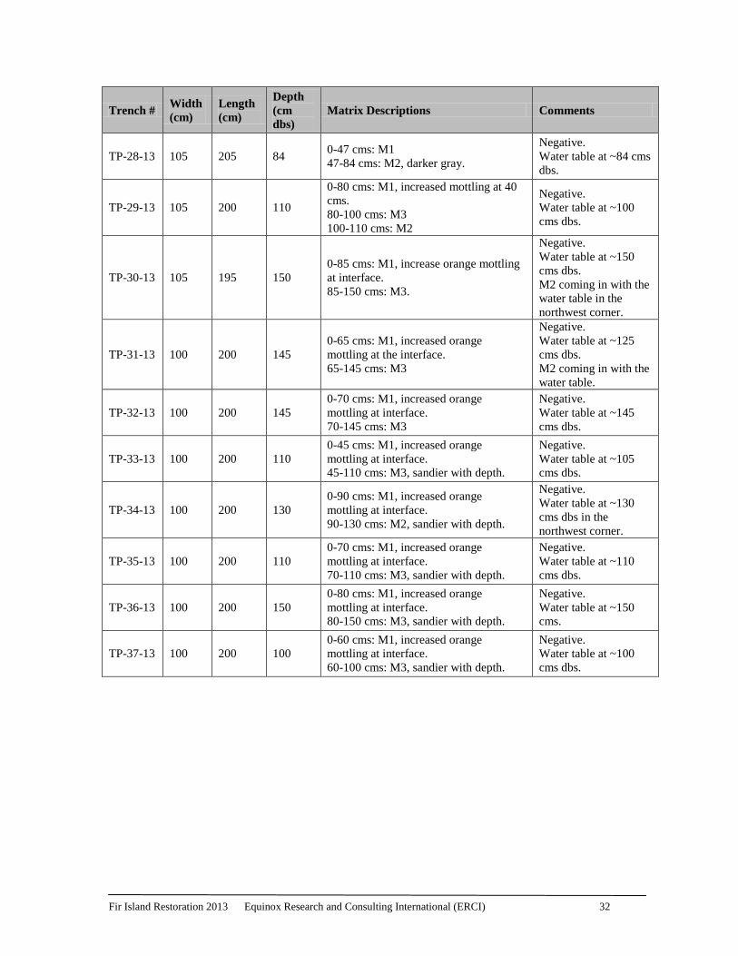
Fir Island Restoration 2013 Equinox Research and Consulting International (ERCI) 32
Trench # Width
(cm)
Length
(cm)
Depth
(cm
dbs)
Matrix Descriptions Comments
TP-28-13 105 205 84 0-47 cms: M1
47-84 cms: M2, darker gray.
Negative.
Water table at ~84 cms
dbs.
TP-29-13 105 200 110
0-80 cms: M1, increased mottling at 40
cms.
80-100 cms: M3
100-110 cms: M2
Negative.
Water table at ~100
cms dbs.
TP-30-13 105 195 150
0-85 cms: M1, increase orange mottling
at interface.
85-150 cms: M3.
Negative.
Water table at ~150
cms dbs.
M2 coming in with the
water table in the
northwest corner.
TP-31-13 100 200 145
0-65 cms: M1, increased orange
mottling at the interface.
65-145 cms: M3
Negative.
Water table at ~125
cms dbs.
M2 coming in with the
water table.
TP-32-13 100 200 145
0-70 cms: M1, increased orange
mottling at interface.
70-145 cms: M3
Negative.
Water table at ~145
cms dbs.
TP-33-13 100 200 110
0-45 cms: M1, increased orange
mottling at interface.
45-110 cms: M3, sandier with depth.
Negative.
Water table at ~105
cms dbs.
TP-34-13 100 200 130
0-90 cms: M1, increased orange
mottling at interface.
90-130 cms: M2, sandier with depth.
Negative.
Water table at ~130
cms dbs in the
northwest corner.
TP-35-13 100 200 110
0-70 cms: M1, increased orange
mottling at interface.
70-110 cms: M3, sandier with depth.
Negative.
Water table at ~110
cms dbs.
TP-36-13 100 200 150
0-80 cms: M1, increased orange
mottling at interface.
80-150 cms: M3, sandier with depth.
Negative.
Water table at ~150
cms.
TP-37-13 100 200 100
0-60 cms: M1, increased orange
mottling at interface.
60-100 cms: M3, sandier with depth.
Negative.
Water table at ~100
cms dbs.
Fir Island Restoration 2013 Equinox Research and Consulting International (ERCI) 33
Appendix 2: Unanticipated Discovery Protocol
In the event that any ground-disturbing activities or other project activities related to this development
or in any future development uncover protected cultural material (e.g., bones, shell, antler, horn or
stone tools), the following actions will be taken:
1. When an unanticipated discovery of protected cultural material occurs, the contractor or on
site project manager will cease work and completely secure the location. Then to determine
the appropriate and legal plan of action for the protected cultural resources, the on-site
representative will contact:
a. Dave Cline, PE of Shannon and Wilson Inc. (206)-6885
b. The property owner/s: Washington Department of Fish and Wildlife
(360)902-2267 or Robert Hayton (360-708-6647)
c. The Department of Archaeology and Historic Preservation (DAHP): Robert
Whitlam (360-586-3080)
d. The Swinomish Indian Tribal Community Cultural Resources Larry
Campbell (360-466-7352)
e. A professional archaeologist
2. If the discovery may be human remains, the contractor or on-site project manager will stop
work in and adjacent to the discovery, completely secure the work area moving the land-
altering equipment to a reasonable distance to continue working and will immediately
contact:
a. Dave Cline, PE of Shannon and Wilson Inc. (206)-6885
b. The property owners: Washington Department of Fish and Wildlife
(360)902-2267 or Robert Hayton (360-708-6647)
c. The Skagit County Sheriff, Richard Grimstead (360-336-9450) and the
Skagit County Coroner, Daniel Dempsey (360-336-9431), to determine if the
remains are forensic. If the remains are not forensic the Department of
Archaeology and Historic Preservation State Physical Anthropologist, Guy
Tasa (360-586-3534) will take the lead in management of the human
remains.
Cultural material that may be protected by law could include but not be limited to:
Logging, mining, or agriculture equipment older than 50 years
Historic bottles and soldered dot cans
Buried layers of black soil with layers of shell, charcoal, fish and mammal bones
Buried cobbles that may indicate a hearth feature
Non natural sediment or stone deposits that may be related to activity areas of people
Stone tools or stone flakes
Stone, bone, shell, horn, or antler tools that may include projectile points (arrowheads),
scrapers, cutting tools, wood working wedges or axes, and grinding stones
Perennially damp areas may have preservation conditions that allow for remnants of wood
and other plant fibers; in these locations there may be remains including fragments of
basketry, weaving, wood tools, or carved pieces
Human remains
Fir Island Restoration 2013 Equinox Research and Consulting International (ERCI) 34
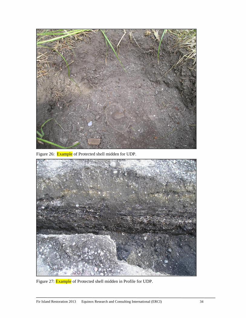
Figure 26: Example of Protected shell midden for UDP.
Figure 27: Example of Protected shell midden in Profile for UDP.
Fir Island Restoration 2013 Equinox Research and Consulting International (ERCI) 35
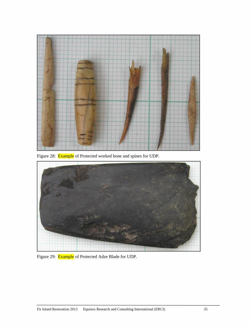
Figure 28: Example of Protected worked bone and spines for UDP.
Figure 29: Example of Protected Adze Blade for UDP.
Fir Island Restoration 2013 Equinox Research and Consulting International (ERCI) 36
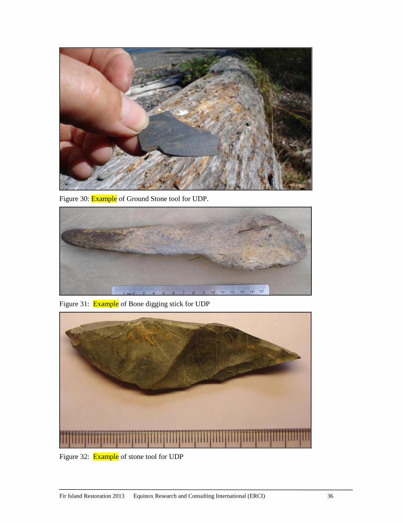
Figure 30: Example of Ground Stone tool for UDP.
Figure 31: Example of Bone digging stick for UDP
Figure 32: Example of stone tool for UDP

Fir Island Restoration 2013 Monitoring 10-348
Equinox Research and Consulting International (ERCI) 37
Appendix 4: Contact List
Name Affiliation Telephone Email
David Cline, PE Shannon and
Wilson Inc. (206) 695-6885 [email protected]
Brian Williams WDFW (360) 466-4345
x 250 [email protected]
Marc Duboiski
Washington State
RCO, Skagit
Watershed
360-902-3137 [email protected]
Larry Campbell SITC 360-466-1236 [email protected]
Robert Whitlam DAHP 360-856-3080 [email protected]
Guy Tasa DAHP 360-586-3534 [email protected]
Richard
Grimstead
Skagit County
Sheriff 360-336-9450 [email protected]
Daniel Dempsey Skagit County
Coroner 360-336-9431 [email protected]
Kelly Bush ERCI 360-826-4930 [email protected]