Cultural Resources Inventory for the Sol Orchard … Resources Inventory for the Sol Orchard Solar...
28
Cultural Resources Inventory for the Sol Orchard Solar Farm Project in the City of El Centro Imperial County, California Submitted to: Sol Orchard, LLC. PO Box 222416. Carmel, CA 93923 Submitted by: 215 N. 5th Street Redlands, CA 92374 (909) 307-0046 (909) 307-0056 fax JULY 2012
Transcript of Cultural Resources Inventory for the Sol Orchard … Resources Inventory for the Sol Orchard Solar...
Cultural Resources Inventory for the Sol Orchard
Solar Farm Project in the City of El Centro Imperial County, California
Submitted to:
Sol Orchard, LLC. PO Box 222416.
Carmel, CA 93923
Submitted by:
215 N. 5th Street Redlands, CA 92374
(909) 307-0046 (909) 307-0056 fax
JULY 2012

2011-156
Cultural Resources Inventory for the Sol Orchard Solar Farm Project in the City of El Centro, Imperial
County, California
July 2012
Prepared For:
Sol Orchard, LLC PO Box 222416.
Carmel, CA 93923
Prepared By:
Wendy Jones, Evelyn Chandler and Roger Mason
ECORP CONSULTING, INC. 215 North 5th Street
Redlands, California 92374 Cultural Resources Identified:
Two newly identified sites (Sol-1, a Historic-period foundation and Sol-2, Historic-period metal rails/foundation) Two elements of the built environment (Sol-11 [Villa Road] and Sol-12 [Central Drain]) 10 isolated resources One previously recorded site (P13-009016)
U.S. Geological Survey 7.5-minute Quadrangle: El Centro, California 1957 (photorevised 1976) Area Surveyed: Approximately 123 acres Keywords: Cultural Resources Survey, El Centro, Ethnohistory, History, Imperial C ounty, Im perial Irrigation District, Prehistory, Salton Sea, Tipai-Ipai

ii
MANAGEMENT SUMMARY
A cultural resources investigation of a project area located within the City of El Centro, Imperial County, California was completed on July 16, 2012 by ECORP Consulting, Inc. (ECORP) under contract to Sol Orchard, LLC. Sol Orchard, LLC. proposes to build a solar farm on approximately 123 acres of land in northeastern El Centro. The purpose of this investigation is to identify potential historical resources that could be affected by the p roposed project, pursuant to the terms of the California Environmental Quality Act (CEQA). A cultural resources records search was conducted to identify known archaeological s ites and historic r esources t hat have been recorded i n t he v icinity o f t he p roposed solar farm, and to determine the extent of previous cultural resources surveys. The record search indicated that there are no previously recorded cultural resources within the project area. The record search also indicated that approximately 50 percent (about 61 acres) of the approximately 123-acre project study area has been previously surveyed for cultural resources; three of the seven surveys that cross the project study area are less than 10 years old. Surveys are considered current for a period of no more than 10 years. Approximately 40 percent (about 49 acres) of the project study area has been surveyed in the last 10 years. Approximately 74 acres in the southern portion of the project study area has not been surveyed within the last 10 years. These 74 acres were surveyed during the current project. Pedestrian survey of the project area identified 15 cultural resources. These include 2 historic-period s ites (Sol-1 and Sol-2), 10 isolated resources (Sol-3-I, Sol-4-I, So l-5-I, So l-6-I, So l-7-I, Sol-8-I, Sol-9-I, Sol-10-I, Sol-13-I, and Sol-14-I), 2 historic-period elements of the built environment (Sol-11 [Villa Road] and Sol-12 [Central Drain]), and the extension of 1 previously recorded resource (P13-009016), an electrical transmission line. No prehistoric resources were identified within the project area. The majority of the project area is highly disturbed with evidence of tilling/grading throughout and modern debris littering the project area. Based on the number of artifacts found within the project area, the archaeological sensitivity of the p roject ar ea i s b elieved t o b e h igh e ven t hough t he maj ority o f i ndividual ar tifacts ar e disturbed and not in situ. Thus, ECORP recommends that, prior to any construction, the resources i dentified d uring t his s urvey be e valuated using California R egister of H istorical Resources (CRHR) evaluation criteria. In addition, all future ground disturbing activities should be monitored by a qualified archaeological monitor.

CULTURAL RESOURCES INVENTORY FOR THE SOL ORCHARD SOLAR FARM PROJECT IN THE CITY OF EL CENTRO, IMPERIAL COUNTY, CALIFORNIA
ECORP Consulting, Inc. ii July 2012
TABLE OF CONTENTS 1.0 INTRODUCTION ....................................................................................... 1 2.0 LOCATION AND SETTING ........................................................................ 1 3.0 CULTURAL SETTING................................................................................. 5 3.1 Prehistory ................................................................................................ 5 3.2 Ethnohistory ............................................................................................. 7 3.3 History ..................................................................................................... 8 4.0 METHODS ............................................................................................... 11 4.1 Records Search Methods ..................................................................... 11 4.2 Field Survey Methods.......................................................................... 11 5.0 RESULTS ................................................................................................ 12 5.1 Record Search Results ........................................................................ 12 5.2 Field Survey Results ........................................................................... 15 5.2.1 Newly Recorded Resources ......................................................... 15 5.2.2 Elements of the Built Environment .............................................. 16 5.2.3 Isolated Finds ............................................................................ 17 5.2.4 Previously Recorded Resources ................................................... 17 6.0 SUMMARY AND RECOMMENDATIONS ................................................... 18 7.0 REFERENCES .......................................................................................... 19 8.0 REPORT AND FIELD PERSONNEL .......................................................... 22 8.1 Report Preparers ................................................................................ 22 8.2 Field Personnel ................................................................................... 22
LIST OF TABLES
Table 1. Previous Investigations within 0.5-mile of the project area ............................. 12 Table 2. Previously Recorded Cultural Resources within 0.5 mile of the Project Area .... 14 Table 3. Newly Recorded Isolated Finds ................................................................... 17
LIST OF FIGURES Figure 1. Project Area Vicinity, Imperial County, California ........................................... 2 Figure 2. Project Location Map ................................................................................... 3 Figure 3. Northern portion of the project area ............................................................ 4 Figure 4. Southern portion of the project area ........................................................... 4

CULTURAL RESOURCES INVENTORY FOR THE SOL ORCHARD SOLAR FARM PROJECT IN THE CITY OF EL CENTRO, IMPERIAL COUNTY, CALIFORNIA
ECORP Consulting, Inc. iii July 2012
APPENDICES
Appendix A Site Location Overview Map (CONFIDENTIAL) Appendix B DPR Archaeological Site Records (CONFIDENTIAL) Appendix C DPR Primary Records (CONFIDENTIAL). Appendix D DPR Updates for Previously Recorded Sites (CONFIDENTIAL)

CULTURAL RESOURCES INVENTORY FOR THE SOL ORCHARD SOLAR FARM PROJECT IN THE CITY OF EL CENTRO IMPERIAL COUNTY, CALIFORNIA
ECORP Consulting, Inc. 1 July 2012
1.0 INTRODUCTION A cultural resources investigation was conducted for an approximately 123-acre project area located in the City of El Centro, Imperial County, California in support of Sol Orchard, LLC.’s Sol Orchard Solar Farm Project. The project area is located on land owned by the Imperial Irrigation District (IID) on the northeastern side of El Centro. The study was completed by ECORP Consulting, Inc. (ECORP) in order to identify historical resources that could be affected by the proposed project, pursuant to the terms of the California Environmental Quality Act (CEQA). To identify existing cultural resources that would be affected by the proposed project, a cultural resources records search was conducted by the South Coastal Information Center (SCIC), San Diego State University, San Diego, California. Following a review of the records search results, an intensive field survey was conducted for the portion of the project area that had not been surveyed within the last 10 years (approximately 74 acres). This report presents the methods and results of the records search and the field survey that was conducted for the project, along with management recommendations. 2.0 LOCATION AND SETTING The p roject area i s an approximately 123-acre parcel located i n the northeastern part o f t he City of El Centro, Imperial County (Figure 1). The project area is situated in the Imperial Valley Basin approximately 2.5 miles west of Highway 111, 9.50 miles north of the U.S/Mexican Border and 22 miles southeast of the Salton Sea. As shown on the U.S. Geological Survey (USGS) 7.5-minute, El Centro, California topographic quadrangle map 1957 (photorevised 1979), the project area l ies within Sections 47 and 48 of Township 15 South, Range 14 East of the San Bernardino Base and Meridian (Figure 2). The southern part of the project area is in the City of El Centro, while the northern part is in unincorporated Imperial County.

MEXICO
Joshua TreeNational
Park
Anza-BorregoDesert State
Park
Salton Sea State Rec. Area
SaltonSea
El CentroEl Centro
BombayBombayBeachBeach
BrawleyBrawley
CalexicoCalexico
CalipatriaCalipatria
CoachellaCoachella
DesertDesertShoresShores
HeberHeber
HoltvilleHoltvilleImperialImperial
MeccaMecca
NilandNiland
OcotilloOcotillo
SaltonSaltonCityCity
SaltonSaltonSea BeachSea Beach
SeeleySeeley
ThermalThermal
RiversideCounty
ImperialCounty
San DiegoCounty
78
111
8
177
195
111
115
7886
8
98
10
Figure 1. Project Vicinity2011-156 Sol Orchard Solar
Location: N:\2011\2011-156 Sol Orchard Solar\MAPS\Site_Vicinity\Sol_CR_Vicinity.mxd (ECK, 7/12/2012) Map Date: 7/12/2012Source: ESRI
P a c i f i c O c e a n
Reno
Fresno
Santa AnaLos Angeles
Oakland
San Jose
San Diego
Las Vegas
Long Beach
Bakersfield
Sacramento Carson City
San Francisco
CACA
NVNV
UTUT
AZAZ
OROR IDID
ekeethe
0 5 10
Mi les
1 inch = 10 miles
Project Site
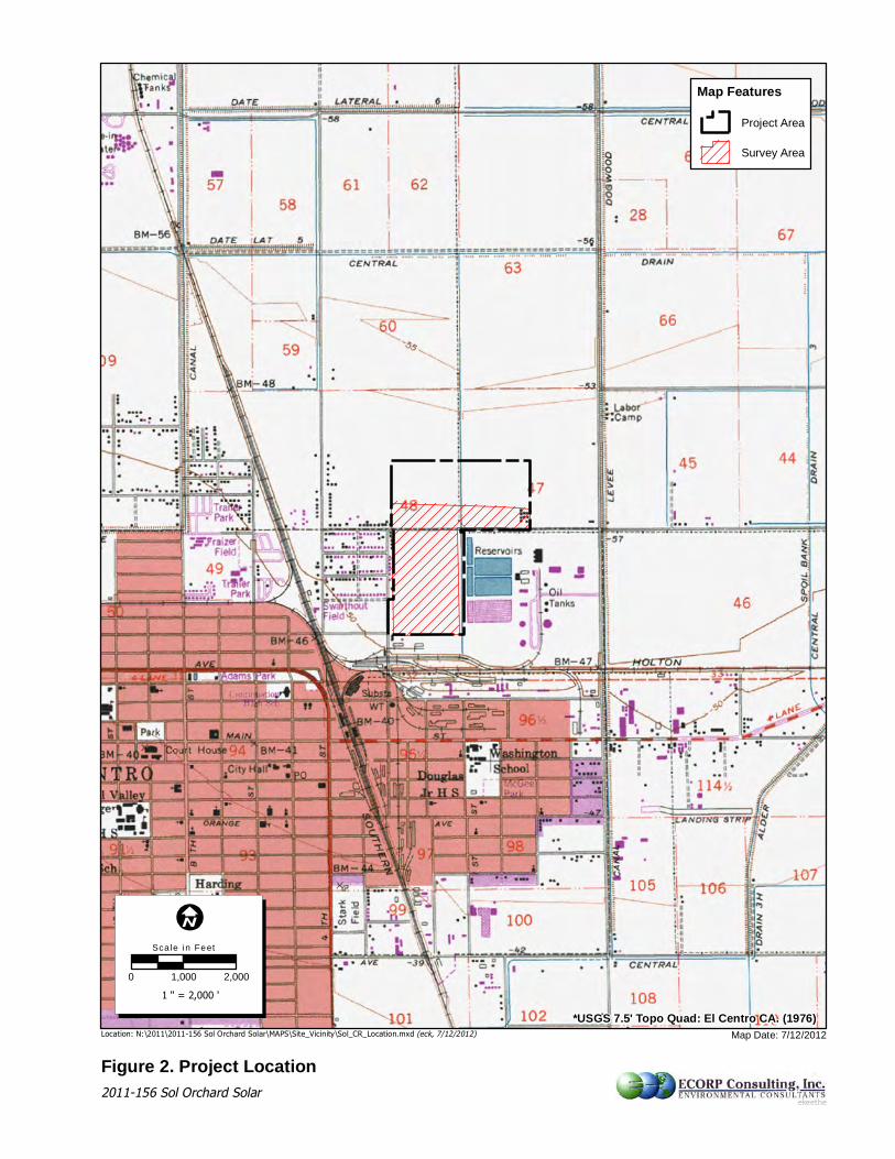
Figure 2. Project LocationLocation: N:\2011\2011-156 Sol Orchard Solar\MAPS\Site_Vicinity\Sol_CR_Location.mxd (eck, 7/12/2012)
0 1,000 2,000
Sca le i n Feet
1 " = 2,000 '
Map Date: 7/12/2012
ekeethe2011-156 Sol Orchard Solar
Map FeaturesProject Area
Survey Area
*USGS 7.5' Topo Quad: El Centro CA. (1976)

CULTURAL RESOURCES INVENTORY FOR THE SOL ORCHARD SOLAR FARM PROJECT IN THE CITY OF EL CENTRO IMPERIAL COUNTY, CALIFORNIA
ECORP Consulting, Inc. 4 July 2012
The Project Area is bordered by North 3rd Street to the west and agricultural fields to the north, south and east. The closest roads are North 3rd Street to the west, East Commercial Avenue to the south, Dogwood Road to the east, and West Aten Rd. to the north. West Villa Road, which turns into East Villa Avenue, runs east-west through the center of the project area and is the city boundary. The project area is situated at an elevation of 48 feet (14.6 meters) below mean sea level. The soil in the project area consists of alluvial sediments originating from Quaternary alluvial and marine deposits, Quaternary sand deposits, Pliocene marine rocks, Mesozoic granitic rocks, Precambrian igneous and metamorphic rocks, and tertiary volcanic deposits found in hills surrounding Imperial Valley (US Geological Survey 2008). There is very little vegetation in the project area which has been tilled and graded (Figures 3 and 4).
Figure 3. Northern portion of the project
area. View east. 07/16/2012. Photo # 001
Figure 4. Southern portion of the project
area. View northeast. 07/16/2012. Photo # 024

CULTURAL RESOURCES INVENTORY FOR THE SOL ORCHARD SOLAR FARM PROJECT IN THE CITY OF EL CENTRO IMPERIAL COUNTY, CALIFORNIA
ECORP Consulting, Inc. 5 July 2012
3.0 CULTURAL SETTING 3.1 Prehistory Colorado Desert Prehistory Little archaeological material dating to the Early and Middle Holocene Periods (8,000 to 1,000 B.C.) is known from the Salton Trough area of the Colorado Desert. The only indications of use of this area during this long period o f t ime consist o f l arge bifacial dart points found on relic lake b eds o f L ake Cah uilla an d o n d esert p avement. T hese i nclude p rojectile p oint t ypes common in the Mojave Desert such as Lake Mojave, P into, and E lko (Schaefer and Laylander 2007:249). The sparse occupation during the middle Holocene may be related to extremely arid climatic conditions and of the lack of water in the Salton Trough (absence of Lake Cahuilla). The Salton Sea Naval Test Base study (Apple et al. 1997) has produced evidence for Archaic occupation on the west side of the Salton Trough. Pinto series and Elko series projectile points recovered during investigations at the Test Base yielded a date of 5,840 +/-250 years B.P. (Apple, et al 1997). These data suggest the desert area of southeastern California was not entirely abandoned during the Desert A rchaic Period. While t he population o f t he region was probably sparse, small bands of mobile Desert Archaic people most likely moved among areas where water (at springs) and plant food resources were available. A few temporary camps with living surfaces and hearths dating to the period 1,000 B.C. to A.D. 700 (Late Archaic Period) are located away from the lake bed in canyons and in the upper Coachella Valley above the maximum lake level. However, two temporary camps dating to the first millennium B.C. that contain fish and waterfowl bone in the Coachella Valley along the maximum Lake Cahuilla shoreline indicate there may have been a lake stand during this period (Schaefer and Laylander 2007:249). Higher population and greater numbers of sites appear to correlate with the presence of Lake Cahuilla which filled the Sal ton Trough when water flowed into the t rough from the Co lorado River. W hen w ater ce ased t o f low f rom t he r iver, t he l ake dried, m arkedly r educing t he availability of r esources. Occupation of t he Salton Trough during the Late Prehistoric Period (A.D. 700 to Contact) correlates with three cycles of inundation and desiccation in Lake Cahuilla that occurred between A.D. 1,200 and 1,680 (Schaefer and Laylander 2007). When the lake was present, lacustrine resources, such as fish, shellfish, and waterfowl were available. When the lake was absent, very few resources were available and human population was low. Lake Cahuilla was much larger than the current Salton Sea. Whereas the current Salton Sea shoreline is about -70 meters (230 feet) below sea level, the maximum Lake Cahuilla shoreline was about sea level (Schaefer and Laylander 2007:Figure 16.1). To the northwest, in the Coachella Valley, the intermittent Whitewater River entered Lake Cahuilla near Point Happy between what is now Indian W ells an d I ndio. Se veral L ate P rehistoric ar chaeological s ites h ave b een i nvestigated along the ancient Lake Cahuilla shoreline in this area. To the south, the entire Imperial Valley between East Mesa and West Mesa was underwater when Lake Cahuilla was present. During the Late Prehistoric Period, the northern part of the Salton Trough (northern Salton Sea area an d t he Co achella V alley) was o ccupied by an cestors o f t he T akic-speaking Cah uilla (Schaefer and Laylander 2007:Figure 16.1). They al so occupied the ad jacent Santa Rosa and San Jacinto Mountains. Large multi-seasonal residential bases were occupied along the ancient
CULTURAL RESOURCES INVENTORY FOR THE SOL ORCHARD SOLAR FARM PROJECT IN THE CITY OF EL CENTRO IMPERIAL COUNTY, CALIFORNIA
ECORP Consulting, Inc. 6 July 2012
shorelines i n t he Co achella V alley wh en L ake Cah uilla was p resent. T hese s ites co ntain abundant fish bone, waterfowl bone, and shell from freshwater shellfish. Animal and plant remains i ndicated u se of both l owland and upland r esources. Floral r emains indicated use of these sites during all four seasons Cottonwood and Desert Side-Notched ar row points, along with buff ware ceramics and Late Prehistoric marine shell beads, indicate occupation during the Late P rehistoric Period (Warren 1984:407). These s ites were l ikely occupied during the three Lake Cahuilla lake stands between A.D. 1,200 and 1,680. The final desiccation is marked by 15 episodes of fish trap construction (along 15 successively lower shorelines) as the lake receded (Warren 1984:407). Mexican accounts document Cahuilla irrigation agriculture in the Coachella Valley during the historic period. Co rn, pumpkins, and melons were grown using small scale irrigation systems (ditches/dams and pot irrigation from walk-in wells). There is little or no archaeological evidence (mac robotanical r emains o r p ollen) f or t he u se o f d omesticates fr om p rehistoric components. The Cahuilla could have obtained domesticates during the early historic period from t he Sp anish mi ssions n ear t he c oast o r from t he Y umans t o t he s outh (Sc haefer an d Laylander 2007:253-254). The s outhern part o f the Sal ton T rough was occupied b y an cestors o f t he Y uman-speaking Tipai, Kumeyaay, or Kamia (Schaefer and Laylander 2007:Figure 16.1). This area included the Imperial Valley, the Yuha Desert, and the mountains to the west and east. The lower Colorado River area was occupied by ancestors of the Yuman-speaking Quechan. Late Prehistoric archaeological sites in this area belong to the Patayan pattern characterized by use of the bow and arrow and ceramics. Patayan I begins about A.D. 700 with the introduction of the bow and arrow, indicated archaeologically by the presence of small projectile points (arrow points) and, along the Colorado River, by the appearance of ceramics. Patayan ceramics first appeared about A.D. 870 on the east shore of Lake Cahuilla and were probably introduced by Yuman people from the Colorado River. Elsewhere, in the southern Salton Trough area, ceramics first appear about A.D. 1000 at the beginning of Patayan II. Patayan I ceramics along the Colorado River include Black Mesa Buff and Colorado Beige. Patayan II (A.D. 1000 – 1700) and III (A.D. 1700 – 1850) ceramics include Tumco Buff and Colorado Buff. There i s also a Salton Brown ware that is transitional between the valley buff wares and the Tizon Brown ware of the Peninsular Ranges to the west (Schaefer and Laylander 2007:252). The Co lorado R iver Y umans p racticed h orticulture b eginning i n P atayan I . D omesticates including corn and squash probably came from the Hohokam area of Arizona or from northern Mexico. At the time of European contact the Imperial Valley Yumans were practicing floodplain agriculture using small dams and ditches along the New and Alamo Rivers. Horticulture in the Imperial Valley probably began after the last recession of Lake Cahuilla during Patayan III using domesticates obtained from the Colorado River Yumans (Schaefer and Laylander 2007:253). Along t he l ower C olorado R iver, t he P atayan s ettlement-subsistence s ystem co nsisted o f horticulture, h unting, an d g athering i n r iparian h abitats. P eople l ived i n mu lti-seasonal residential bases along the r iver. When Lake Cahuilla was p resent in the Sal ton Trough, they also occupied temporary camps for fishing, hunting, and gathering on the eastern shore of Lake Cahuilla. On the west s ide of the Sal ton Trough, the Patayan pattern consisted of a s easonal round among upland and lowland habitats. When Lake Cahuilla was present, seasonal residential bases and temporary camps were occupied on the western shore of Lake Cahuilla in
CULTURAL RESOURCES INVENTORY FOR THE SOL ORCHARD SOLAR FARM PROJECT IN THE CITY OF EL CENTRO IMPERIAL COUNTY, CALIFORNIA
ECORP Consulting, Inc. 7 July 2012
order t o o btain l acustrine r esources i ncluding fi sh, s hellfish, an d wat erfowl (Sc haefer an d Laylander 2007:253). Obsidian from the Obsidian Butte source on the southeast margin of the Salton Sea was used for making flaked stone tools throughout southern California during the Late Prehistoric Period. However, obsidian from Obsidian Butte could only be obtained when lake levels were low, since it i s at an e levation of -40 meters (130 feet below sea level). I t i s possible that the Imperial Valley Yumans traded obsidian for food resources from other groups when lacustrine resources from Lake Cahuilla were not available. Exchange patterns are also indicated by the presence of numerous marine shell beads (made in the coastal Chumash area) in L ake Prehistoric Takic-speaking Cahuilla sites, but not in Yuman-speaking areas (Schaefer and Laylander 2007:255). 3.2 Ethnohistory Tipai-Ipai The predominant Native American people occupying the region encompassing the project area at the time of European contact in the late 18th century were the Tipai-Ipai. The Tipai and Ipai are subgroups of the Kumeyaay Nation. Eighteenth-century Spanish explorers and settlers used the collective term “Diegeño” for these people, which referred to bands living near the presidio and mission of San Diego de Alcalá. Today, members of the tribe prefer to be called Kumeyaay as a wh ole or distinguished as T ipai or Ipai (Luomala 1978). A lthough some d istinctions exist between these subgroups, they are linguistically and culturally similar and will, therefore, be discussed as one tribal group in this section. The territory of the Tipai-Ipai extended north from Todos Santos Bay near Ensenada, Mexico to the mouth of the San Luis Rey River in north San Diego County, and east to the Sand Hills on the east side of Imperial Valley. The Tipai occupied the southern and eastern desert portions of the territory, while the Ipai inhabited the northern coastal region (Luomala 1978). The primary source of Tipai-Ipai subsistence was vegetal food. Seasonal travel followed the ripening of plants from the lowlands to higher elevations of the mountain slopes. Buds. blossoms, potherbs, wild seeds, cactus fruits, and wild plums were among the diet of both groups. The T ipai p racticed l imited ag riculture within t he fl oodplain ar eas o f t heir t erritory. Melons, maize, beans, cowpeas, and teparies were planted. Women sometimes transplanted wild onion and tobacco plants t o convenient l ocations, and sowed wild tobacco seeds. Deer, rodents, and birds provided meat as a secondary source of sustenance. Families also gathered acorns and piñon nuts at the higher altitudes. Village locations were selected for seasonal use and were occupied by exogamous, patrilineal clans. Three or four clans would winter together, then disperse into smaller bands during the spring and summer (Luomala 1978). Tipai-Ipai structures varied with the seasons. Summer shelter consisted of a wind break, tree, or a cave fronted with rocks. Winter dwellings had slightly sunken floors with dome-shaped structures made of brush thatch covered with grass and earth (Gifford 1931; Luomala 1978). Upon death, the Tipai-Ipai cremated the body of the deceased. Ashes were placed in a ceramic urn an d b uried o r h idden i n a c luster o f r ocks. T he fami ly c ustomarily h eld a mo urning ceremony one year after the death of a family member. During this ceremony, the clothes of

CULTURAL RESOURCES INVENTORY FOR THE SOL ORCHARD SOLAR FARM PROJECT IN THE CITY OF EL CENTRO IMPERIAL COUNTY, CALIFORNIA
ECORP Consulting, Inc. 8 July 2012
the deceased individual were burned to ensure that the spirit would not return for h is or her possessions (Gifford 1931; Luomala 1978). It is estimated that the precontact Tipai-Ipai population ranged from approximately 3,000 (Kroeber 1925) to 9,000 (Luomala 1978). Beginning in 1775, the semi-nomadic life of the Tipai-Ipai began to change as a result of contact with European-Americans, particularly from the influence of the Spanish missions. Through successive Spanish, Mexican, and Anglo-American control, the Tipai-Ipai were forced to adopt a sedentary lifestyle and accept Christianity (Luomala 1978). As of 1968, Tipai-Ipai population was somewhere between approximately 1,322 (Shipek 1972, included in Luomala 1978) and 1,522 (Luomala 1978). 3.3 History The history of the El Centro region since the time of European contact (late 1700s) is characterized by several themes, including exploration, transportation, irrigation and creation of the Salton Sea. Each of these contributed to the growth and development of communities in the region. Exploration. In 1772 and 1774, two different expeditions crossed the Imperial Valley in search of a t ravel r oute ac ross t he d esert. B oth o f t hese e xpeditions v isited an I ndian s ettlement located about 12 miles west of the current southwestern shore of the Salton Sea, which later became known as San Sebastian, and recorded some of the flora and fauna that they encountered during t he trip. No o ther trips through the Salton Sink region are mentioned in official records for several decades. During this period, several asistencias associated with the Spanish missions were established in Redlands, Santa Ysabel, and Pala. Given their distance from the Coachella Valley, they had little impact on the settlement of the area, but did have an impact on the lives of the native inhabitants of the region. By t he M exican P eriod (b eginning i n 1821) mail was b eing c arried b y Maricopa In dian messengers between Sonora and the California coast, via the northern Colorado Desert and the San Gorgonio Pass. During roughly the same period, from 1815 to the 1830s, Indians from San Gabriel Mission made annual t rips into the Sal ton Sink to collect salt (Hoyt 1948; F itch 1961; Johnston 1977; Pourade 1971; Bannon 1974; Nordland 1977). In 1825, Captain Jose Maria Romero led a small party from the Los Angeles area through the San Gorgonio Pass and across the Coachella Valley east to Blythe in search of a t ransportation route from the Los Angeles/San Diego area to Arizona. Once reaching the Colorado River, they turned south towards Yuma. After the journey, a southern route, which ran directly from Yuma to San Diego via the present-day site of Brawley, was deemed preferable to the San Gorgonio-Blythe route and the “Southern Route” became the official road from Sonora to Alta California (Hoyt 1948; Johnston 1977; Nordland 1977; Pourade 1971). Ranchos, predominant in other portions of California, were not established in the Salton Sink area during this period. Transportation. During the Gold Rush of the late 1840s and early 1850s, thousands of prospectors and other immigrants came to California by the Southern Route. Semi-weekly stage service by the Butterfield Overland Mail Company, crossing Imperial Valley from Yuma to San

CULTURAL RESOURCES INVENTORY FOR THE SOL ORCHARD SOLAR FARM PROJECT IN THE CITY OF EL CENTRO IMPERIAL COUNTY, CALIFORNIA
ECORP Consulting, Inc. 9 July 2012
Diego and Los Angeles, was begun along this route in 1858 (Dowd 1960; Fitch 1961). This service ended at the beginning of the Civil War, however. In 1862, gold was discovered near Blythe, creating the need for a direct route eastward from California to Arizona. In response to this need, William D. Bradshaw used existing roads to travel from Los Angeles to Dos Palmas Oasis near the present northeastern shore of the Salton Sea. From there, Bradshaw’s party crossed the Orocopia and Chuckwalla Mountains and followed ancient Indian trails east using a map drawn for them by Cabazon, a Cah uilla chief, reaching the Colorado River just northeast of Blythe (Johnson 1977; Ross 1992). The Bradshaw trail was the main means of communication between southern California and the eastern part of the United States until the completion in 1883 of the Southern Pacific Railroad from Los Angeles to New Orleans via Indio, Dos Palmas, and Yuma. By the 1880s, passenger coaches were discontinued in favor of the railroad, and commerce took the form predominantly of express and mail contracts carried by mule trains and freight wagons (Johnston 1977; Ross 1992). In 1904, a southern branch of the railroad was constructed from Old Beach (now Niland) on t he mai n So uthern P acific r oute to C alexico via E l Ce ntro an d a s eparate l ine was constructed from El Centro to Holtville. A railroad connection between El Centro and San Diego was completed in 1919 and eventually connected wi th existing l ines to eastern Arizona (Hoyt 1948; Fitch 1961; Lamb 1992). As the popularity of automobiles increased in the early 20th century, need for a route that could accommodate cars and trucks across the Colorado Desert developed. Until the 1920s, most cars traveling fr om San D iego t o Y uma fo llowed o ld wag on r oads, but l oose s and p roved to b e treacherous, p articularly wi thin t he A lgodones Dunes. I n r esponse, a plank r oad ac ross t he dunes was created. This innovative road extended 6.8 miles and was used for about 10 years until U.S. Route 80 (now Interstate 8) was completed in 1927 (Pepper 1973).
Irrigation and Creation of the Salton Sea. Attempts to i rrigate t he Sal ton Si nk r egion began as early as the 1850s, but little progress was made until 1900 when work was started on the Imperial Canal. The canal was built to bring water from the Colorado River to the Imperial Valley and started at a diversion point near Pilot Knob, located 1 mile north of the International border. It ran south into Mexico to avoid extensive sand dunes west of Yuma and then turned northwest to re-enter the United States at Calexico. Water was flowing through this canal to the Imperial Valley by 1902 (Cory 1915; Kennan 1917; Dowd 1960; Fitch 1961).
From little or no cultivation in 1900, agriculture in the Salton Sink area grew to 120,000 acres under cultivation by January of 1905. In the same time period, the population of the area grew from 2,000 to over 10,000. The demand fo r i rrigation meant that al l e fforts were focused on keeping the water flowing. In 1904, a new intake to the canal from the Colorado River was built in Mexico just south of the international border to replace the previous canal head, which had become clogged with silt (Kennan 1917; Fitch 1961).
During the winter o f 1904 t o 1905, a s eries of five fl oods i n a period of j ust several months caused the Co lorado R iver to b reak through the new intake and caused the d ischarge o f the entire river to pour into the Salton Sink, creating the Salton Sea. It was two years before the discharge was b rought under control. The surface o f the Sal ton Sea was at i ts h ighest point, approximately 198 fe et below s ea l evel, c overing ab out 470 s quare mi les wi th a max imum

CULTURAL RESOURCES INVENTORY FOR THE SOL ORCHARD SOLAR FARM PROJECT IN THE CITY OF EL CENTRO IMPERIAL COUNTY, CALIFORNIA
ECORP Consulting, Inc. 10 July 2012
depth of 70 feet. Evaporation soon began to lower the surface to its current elevation of approximately 230 feet below sea level. Irrigation run-off and inflow from the Alamo and New Rivers kept the Salton Sea from evaporating further (Cory 1915; Kennan 1917; Fitch 1961; Duke 1974; Woerner 1989).
The Imperial Ir rigation D istrict was established i n July 1911, covering an area o f 817 s quare miles. The Coachella Valley Water District was formed in 1918 and soon began to work with the IID to plan and promote a new canal located entirely within the United States to irrigate both valleys. The All-American Canal was completed from the Colorado River to the Imperial Valley in 1942. By 1948, a branch of it, called the Coachella Canal, was extended to bring water to the Coachella Valley (Cory 1915; Dowd 1960; Fitch 1961; Nordland 1977, 1978). El Centro. El Centro, the largest city in Imperial County, has also been the county seat since 1907. I n 1 904, a b ranch o f t he So uthern P acific R ailroad was c ompleted t o El Ce ntro an d Calexico by the Southern Pacific and the Imperial and Gulf Railroad Company (Robertson 1998). Originally called Cabarker, E l Centro was founded in 1904 by W.F. Holt and C.A. Barker, who bought land f or $40.00 per acre and made $100,000.00 worth of improvements. L ocated 13 miles south of Brawley and 9 miles north of the international boundary, El Centro, as its name implies, is in the center of the Imperial Valley. After the name change and incorporation as a city in 1905, El Centro’s population grew to 1,610 by 1910 and 5,646 by 1920. In addition to being the county seat, the administrative headquarters of the Imperial Irrigation District are located in the city. El Centro is a major agricultural center, and holds an annual Lettuce Festival in celebration of their main crop. It is also the shipping center for agricultural products from the southern portion of Imperial Valley. In recent decades, El Centro has also become the region’s leading g overnment ad ministration, wh olesale, an d r etail t rade c enter. N aval A ir Station, El Centro is headquartered there, and maintains several large tracts of land in the desert to the northwest and northeast o f t he c ity (F itch 1961; Pepper 1973; Lamb 1992; C ity o f El Centro 1999).

CULTURAL RESOURCES INVENTORY FOR THE SOL ORCHARD SOLAR FARM PROJECT IN THE CITY OF EL CENTRO IMPERIAL COUNTY, CALIFORNIA
ECORP Consulting, Inc. 11 July 2012
4.0 METHODS 4.1 Records Search Methods The Cl ass I i nventory b egan wi th an archaeological r ecords s earch c onducted at t he So uth Coastal Information Center (SCIC), San Diego State University in San Diego, California on January 9, 2012. The SCIC is part of the California Historical Resources Information System and is the official repository for all cultural resources site records and reports for Imperial County. The SCIC records search i dentified p revious surveys that have been conducted wi thin a 0.50 mile radius of the study area, as well as cultural resources that have been previously recorded within 0.50 mile of the project a rea. In addition, h istoric maps o f the a rea were reviewed to identify any historic-period structures o r features within the ar ea. The Historic Property Data File was also reviewed to identify any properties that have been listed on or determined eligible for listing on the National Register of Historic Places (NRHP), Cal ifornia Register of H istorical Resources (CRHR), California Points of H istorical Interest, California L andmarks, and National Historic Landmarks within 0.50 mile of the project study area. The records search indicated that approximately 50 percent (about 61 acres) of the approximately 123-acre project study area has been previously surveyed for cultural resources; three of the seven surveys that cross the project study area are less than 10 years old. Surveys are no longer considered current when they are more than 10 years old. Approximately 40 percent (about 49 acres) of the project study area has been surveyed in the last 10 years. Approximately 74 acres in the southern portion of the project study area has not been surveyed within the last 10 years. These 74 acres were surveyed during the current project. 4.2 Field Survey Methods Fieldwork was conducted by ECORP archaeologists on July 16, 2012 and consisted of an intensive systematic pedestrian survey of the project area for evidence of cultural resources. All accessible ar eas wi thin the p roject a rea w ere w alked u sing 15-meter i ntervals b etween transects. Notes were taken on the environmental setting and disturbances wi thin the project area. Newly identified sites were photographed, described, given a temporary number (starting at Sol-1), and recorded using a Trimble GPS unit. Newly identified isolated resources were photographed, described, given an artifact number (starting at Sol-3-I), and recorded using a Trimble GPS unit. Updated Department of Parks and Recreation (DPR) records were prepared for all resources.

CULTURAL RESOURCES INVENTORY FOR THE SOL ORCHARD SOLAR FARM PROJECT IN THE CITY OF EL CENTRO IMPERIAL COUNTY, CALIFORNIA
ECORP Consulting, Inc. 12 July 2012
5.0 RESULTS 5.1 Records Search Results The results of the records search indicated that, between 1989 and 2007, 12 cultural resources investigations were conducted within the records search radius (NADB 1100441, 1100477, 1100659, 1100731, 1100759, 1100773, 1101009, 1101091, 1101182, 1101228, 1101242, and 11011243). Of these studies, seven overlapped, crossed, or took place within the boundaries of the project study area (NADB 1101091, 1100477, 1100773, 1101243, 1101242, 1100731, and 1101182). A listing of all 12 investigations is presented below in Table 1.
Table 1 Previous Investigations within 0.50 mile of the Project Area
Author(s) Report Title and Number Year Location Relative to Study Area
Peak & Associates
Cultural Resources Survey and Clearance – Salton Sea Radio Site to Calexico, Imperial County, California. American Telephone and Telegraph Company’s Fiberoptic Communication Cable (NADB 1100731)
1989 Linear survey, runs through the northeastern portion of the project area.
ENSR Consulting and Engineering
Environmental Assessment/Initial Study for the Placement of Fiber Optic Facilities Between Salton Microwave Station and Calexico California (NADB-1100441)
1990
Linear survey, passed approximately 0.25 mile (402 meters) east of the project area
Imperial Irrigation District
Draft Environmental Impact Report for East Lowline and Trifolium Interceptors, And Completion Projects (NADB 1100477)
1993 Large block survey that encompasses the entirety of the project area
Dolan, Christy C.V.
A Cultural Resources Inventory of the M Transmission Line Pole Replacement Project, Imperial Irrigation District , Imperial County, California (NADB 1100659)
1998
Linear survey, passed approximately 0.25 mile (402 meters) east of the project area
Wallace Roberts & Todd
County of Imperial Bicycle Master Plan (NADB 1100773) 1999
Large block survey that encompasses the entirety of the project area
Romulus, Mark S. Review of Alamosa PCS Site # 82502-029, County of Imperial, California (NADB 1100759)
2000
Block survey, located approximately 0.35 mile (563 meters) south of the project area
CULTURAL RESOURCES INVENTORY FOR THE SOL ORCHARD SOLAR FARM PROJECT IN THE CITY OF EL CENTRO IMPERIAL COUNTY, CALIFORNIA
ECORP Consulting, Inc. 13 July 2012
Author(s) Report Title and Number Year Location Relative to Study Area
Yost, Stephen W., Michael Mirro, Lori Rhodes, J. David Ing, and Howard Higgins
Final Report on Cultural Resources Monitoring Along the Level (3) Long Haul Fiber Optic Running Line, San Diego, California to Yuma, Arizona, San Diego and Imperial Counties
2001 Linear survey, crossed the southwestern portion of the project area
Tang, Bai Historical/Archaeological Resources Survey Report – The Bank of America Project (NADB 1101009)
2006 Block survey, located adjacent to the northern border of the project area
SWCA Environmental Consultants
Volume 1 – Cultural Resources Final Report of Monitoring and Findings for the Qwest Network Construction Project, State of California (NADB 1101228)
2006
Linear survey, located approximately 0.35 mile (563 meters) west of the project area
Bureau of Land Management
Draft Environmental Impact Report and Draft Land Use Plan Amendment – Volumes I and II – North Baja Pipeline Expansion Project (NADB 1101243)
2006 Linear and block survey, crosses the northern portion of the project area
Bureau of Land Management
Final Environmental Impact Statement/Environmental Impact Report and Proposed Land Use Plan Amendment – Volume I and II – North Baja Pipeline Expansion Project (NADB 1101242)
2007 Linear and block survey, crosses the northern portion of the project area
Pavlovick, Salina
Proposed Tower Raw Land Site, Vertical Space/KXO Radio, NE of the Intersection of Cross Road and Villa Road, El Centro, Imperial County, California (NADB 1101091)
2007 Block survey, located in the northwestern portion of the project area
The records search results also show that four cultural resources have been previously recorded within the records search radius (IMP-1866, IMP-8489, P13-009016, and P13-008322). These consist of two historic-period railroad segments (IMP-8166 and IMP 8489), one historic-period railroad station (P13-008322) and one historic-period transmission line (P13-009016). Of these four resources, n one c ross o r l ie wi thin t he p roject s tudy ar ea. D etails o f al l fo ur r ecorded cultural resources are presented below in Table 2. In addition to the previously recorded s ites, the records search results identified two h istoric-period addresses within the records search radius. These addresses are 519 Broadway (P13-008048) and 710 West Main Street (P13-008579) in El Centro. 710 West Main St. is the former location of the Hotel Barbara Worth, which has been nominated for inclusion as a California Point o f H istorical In terest. N either o f these two h istoric-period addresses a re located w ithin the project study area. Details of each are presented below in Table 2.
CULTURAL RESOURCES INVENTORY FOR THE SOL ORCHARD SOLAR FARM PROJECT IN THE CITY OF EL CENTRO IMPERIAL COUNTY, CALIFORNIA
ECORP Consulting, Inc. 14 July 2012
Table 2 Previously Recorded Cultural Resources within 0.50 mile of the Project Area
Location Relative to Study Area
Resource Designation
Age or Period of Resource Description Reference(s)
Located approximately 0.25 mile (400 meters) west of the project area
CA-IMP-8166H P13-008682 Historic
Southern Pacific Railroad, Niland to Calexico Line
Craft, Andrea C., and Michael J. Wise, DPR Record 2005; Collins, Karen and J. Michael Pflaum, DPR Record 2005; Collins, Karen M. DPR Record 2003. On file at the SCIC, San Diego State University, San Diego
Located approximately 0.40 mile (643 meters) west of the project area
CA-IMP-8489 P13-009302 Historic
San Diego and Arizona Eastern Railroad
Krintz, Jennifer, DPR Record 2011; Dalope, Michelle and Shelby Gunderman, DPR Record 2009; URS Corporation, DPR Record 2009; McGinnis, P, DPR Record 2010;McKenna, Jeanette, DPR Record 2007. On file at the SCIC, San Diego State University, San Diego
Located approximately 0.30 mile (480 meters) east of the project area
P13-009016 Historic
Transmission Line running between Dogwood Road and Highway 111
Dolan, C. and Toenjes, J. DPR Record 2005. On file at the SCIC, San Diego State University, San Diego
Located approximately 0.35 mile (563 meters) southwest of the project area
P13-008322 Historic Railroad Station
Bark, R., M. Caldwell, and D. James, DPR Record 1999. On file at the SCIC, San Diego State University, San Diego
Located approximately 0.50 mile (804 meters) southeast of the project area
P13-008579 Historic
Hotel Barbara Worth (nominated for inclusion as a California Point of Historical Interest), 710 West Main Street, El Centro
Elder, Sandra J. DPR Record 2002. Housed at the SCIC, San Diego State University, San Diego. On file at the SCIC, San Diego State University, San Diego
Located approximately 0.50 mile (804 meters) southwest of the project area
P13-008048 Historic
Confucius Church and Community Center, 519 Broadway, El Centro
Way, Nancy, DPR Historic Resources Inventory Form, 1980. On file at the SCIC, San Diego State University, San Diego

CULTURAL RESOURCES INVENTORY FOR THE SOL ORCHARD SOLAR FARM PROJECT IN THE CITY OF EL CENTRO IMPERIAL COUNTY, CALIFORNIA
ECORP Consulting, Inc. 15 July 2012
The review of historic maps included examination of the Blackburn Map of Imperial County, California (1936, 1955, 1964). This map shows multiple roads running throughout the record search radius including Villa Road that runs through the project study area. This map also shows the Southern Pacific Niland to Calexico railroad (CA-IMP-8166) located west of the project area. The US Geological Survey 16-minute Brawley quadrangle map from 1940 also shows Villa Road and the Southern Pacific Niland to Calexico railroad (CA-IMP-8166) and does not show any s tructures o ther than V illa Road in the p roject a rea. The US Geological Survey 7.5-minute El Centro quadrangle map from 1957 shows both of these features, as well as nine structures located within the northern portion of the project area. In addition, a portion of the Central Drain runs north-south through both the northern and southern sections of the project study area. The 1957 map also shows at least 11 structures adjacent to the western border of the project study area and 6 reservoir tanks, with associated oil tanks, located southeast of the project study area. Three of these reservoir tanks are adjacent to the eastern border of the project study area. A transmission line runs parallel to the Central Drain through the northern part of the project area and turns east adjacent to the southern boundary of the northern project study area. The portion of this transmission line that crosses the project study area is not a previously recorded cultural resource. However, this line becomes a previously recorded site (P13-009016) after it crosses the Dogwood Levee to the east. Multiple additional structures and roads are located west of the project study area, but within the record search boundary. The north-south trending Dogwood Levee is located to the east of the project area and what appears to be a railroad switching yard is located just south of the project study area. Of the resources noted on h istoric-period maps, the Southern Pacific Niland to Calexico railroad (CA-IMP-8166), its associated station (P13-008322) and a transmission line (P13-009016) are known, recorded cultural resources. None of these previously recorded resources are located within or directly adjacent to the project study area. 5.2 Field Survey Results Fifteen cultural resources were identified within the project area as a result of the field survey. These include 2 historic-period s ites (Sol-1 and Sol-2), 10 isolated resources (Sol-3-I, Sol-4-I, Sol-5-I, So l-6-I, Sol-7-I, So l-8-I, So l-9-I, So l-10-I, So l-13-I, an d So l-14-I), 2 historic-period elements of the built environment (Sol-11 [Villa Road] and Sol-12 [Central Drain]), and the extension o f 1 previously r ecorded r esource (P13-009016) (Appendix A) . No p rehistoric resources were i dentified wi thin t he p roject area. Approximately 90 percent o f t he surveyed project area has been t illed and g raded, mixing modern debris and trash wi th h istoric-period artifacts. Modern dumping is also present throughout the southern portion of the project area and appears to be associated with both the railroad yard to the south and the houses along the western border of the project area. In addition, modern looking water/irrigation features were noted within the project area. These include two irrigation/hydrant type features, one of which has an attached pipe that may be used to flood the graded fields. 5.2.1 Newly Recorded Resources Sol-1. This site is a group of foundation pads that appear on the 1957 USGS quadrangle map. That map shows a grouping of 9 structures just north of Villa Road. When ECORP archaeologists v isited the s ite during the current project they found that a p ortion of the s ite was covered by a make-shift shanty house and yard that are nestled against a grove of large trees. The portion of the site that is visible consists of three foundation pads (Features 1 to 3)
CULTURAL RESOURCES INVENTORY FOR THE SOL ORCHARD SOLAR FARM PROJECT IN THE CITY OF EL CENTRO IMPERIAL COUNTY, CALIFORNIA
ECORP Consulting, Inc. 16 July 2012
and four outlying wooden posts. A north-south trending unpaved road is located just east of the site. The site is littered with modern trash and debris. No historic-period artifacts were found. There is a grove of large trees to the west of the recorded portion of the site that, due to the proximity of the shanty house, was not explored. Feature 1 i s a poured concrete foundation pad measuring 24.5 feet (east-west) by 26.5 feet (north-south). The eastern third o f the foundation is separated into t hree equal rectangular rooms/closets by a poured concrete wall foundation that appears to contain local cobbles. Feature 2 i s poured concrete foundation pad measuring 37.25 feet (east-west) by 11.75 feet (north-south). This foundation has an additional concrete possible porch foundation added to the south side of the feature. The base of a wooden post is embedded in the southern edge of the foundation and the eastern side contains three embedded steel anchor bolts. Feature 3 is poured concrete foundation pad measuring 37.25 feet (east-west) by 8 feet (north-south). This foundation has an additional concrete smaller foundation pad added to the east side of the feature. The base of a wooden post is embedded in the southeastern corner of the main foundation. A small, l ess t han 2 -meter-square concrete s lab i s l ocated ad jacent t o t he southern side of this feature. One of the people who are currently living in the shanty at the site told archaeologists that the foundations were used for trailers back when the adjacent agricultural fields were in use. She also described finding old milled lumber at the site and finding historic-age pipes when digging in the ground. As stated above, this site appears on the USGS 1957 map. However, this site does not appear on the USGS 16-minute Brawley quadrangle map from 1940 (U.S. Geological Survey 1 940). Thus, i t i s l ikely t hat the s ite was b uilt b etween 1940 and 1 957. A D PR Archaeological Site Record for this site is located in Appendix B. On the USGS 1957 map, a similar c luster of buildings northeast of the s ite is labeled a l abor camp. The s ite appears to represent the remains of housing provided by a farmer for migrant workers that dates to the 1940s or 1950s. Sol-2. Sol-2 i s an enclosed rectangular ar raignment o f s teel r ails t hat are embedded i n t he ground. The steel rails are heavily rusted and show signs of age. There are no accompanying tracks or structures in the immediate vicinity. The outside edge of the rails is surrounded by embedded, poured concrete that is about 6 inches thick. Just to the south of this feature is a fallen me tal e lectrical p ole wi th c eramic i nsulators at tached. T he fu nction o f t his s ite i s unknown. The s ite i s l ocated n orth o f a r ailway y ard, ap proximately 6 80 fe et n orth o f t he Southern Pacific Railway line. At some point the railway yard may have extended north to this point. A DPR Archaeological Site Record for this site is located in Appendix B. 5.2.2 Elements of the Built Environment Sol- 11 (Villa Road). Villa road is an east-west trending road that bisects the northern portion of the project area. As noted above, this road appears on historic-period maps. West Villa Road is a paved street that runs between the Southern Pacific Railroad Tracks 0.40 miles west of the project area to the Central Drain in the middle of the project area. After it crosses the Central Drain, West Villa Road becomes East Villa Avenue and runs east through agricultural fields for an ad ditional t wo mi les b efore t erminating at Can non R oad. A n arrow d rainage

CULTURAL RESOURCES INVENTORY FOR THE SOL ORCHARD SOLAR FARM PROJECT IN THE CITY OF EL CENTRO IMPERIAL COUNTY, CALIFORNIA
ECORP Consulting, Inc. 17 July 2012
channel/irrigation channel runs along the northern border of the road. A DPR primary record was prepared for this site and can be found in Appendix C. Sol-12 (Central Drain). A north-west trending portion of the Central Drain runs through the middle of the northern portion of the project area and along the eastern border of the southern portion of the the project area. As noted above, this feature is depicted on the 1957 quadrangle map and is historic in age. The portion of the Central Drain that runs through the project is approximately 1.40 mile long and runs between Cross Road and Dogwood Road. The canal itself is a dirt lined ditch, approximately 30 feet wide with compacted unpaved access roads on either side of it. At the time of this project the canal contained water with multiple plants and debris within it. The Central Drain is present on the 1957 USGS Quadrangle map. However, this site does not appear on the USGS 16-minute Brawley quadrangle map from 1940 (U.S. Geological Survey 1940). Thus, it is likely that the site was built between 1940 and 1957. A DPR primary record was prepared for this site and can be found in Appendix C. 5.2.3 Isolated finds A total of 10 historic-period isolated finds were identified within the southern portion of the project area. All 10 isolated finds are broken fragments of historic-period glass. Nine of these are sun-colored amethyst (SCA) g lass. B ased on the thickness and design e lements of these fragments it is likely that at least three (Sol-3-I, Sol-4-I, and Sol-6-I) of these isolated finds are from the same glass vessel. The entire southern section of the project area has been heavily disturbed and graded. None of the artifacts in this portion of the project area are complete or in si tu. Thus i t is possible t hat the i solates noted here may represent as few as t hree g lass items t hat h ave b een b roken an d s pread o ver a l arge ar ea d uring t illing o r g rading. DPR Records were prepared for all isolated artifacts. These can be found in Appendix C.
Table 3 Newly Recorded Isolated Finds SL# Primary Number Resource Age Brief Description of Isolate
Sol-3-I -- Historic five fragments from a single SCA glass vessel with a scalloped rim (likely from a decorative jar)
Sol-4-I -- Historic two fragments of SCA glass found 10 meters apart, one of which has a decorative pattern.
Sol-5-I -- Historic one amber glass bottle base with stippling, an Owens Bottle Machine suction scar and an Anchor Hocking maker’s mark
Sol-6-I -- Historic one fragment of SCA glass with a decorative knob on top (likely from a decorative jar)
Sol-7-I -- Historic one fragment of SCA glass Sol-8-I -- Historic one fragment of SCA glass Sol-9-I -- Historic one fragment of SCA glass
Sol-10-I -- Historic SCA glass cork-stop bottle finish (hand finished)
Sol-13-I -- Historic one fragment of SCA glass Sol-14-I -- Historic one fragment of SCA glass

CULTURAL RESOURCES INVENTORY FOR THE SOL ORCHARD SOLAR FARM PROJECT IN THE CITY OF EL CENTRO IMPERIAL COUNTY, CALIFORNIA
ECORP Consulting, Inc. 18 July 2012
5.2.4 Previously Recorded Resources P13-009016 (Transmission line). This transmission line provides power for an Imperial Irrigation District steam plant (Dolan and Toenjes 2005). The portion of the IID transmission line, associated with P13-009016, which crosses the project area was surveyed by Peak and Associates in 1989 (see Table 1). At that time, Peak and Associates did not identify this segment of the transmission line as a cultural resource. In 1998, when Dolan and Toenjes Surveyed the Central Drain, they identified the segment east of the project area as a site (P13-009016). They recorded this site east of the project area, but did not record this transmission line west of Dogwood Levee. The portion of this line that crosses the project area appears on the 1957 USGS Quadrangle map. Therefore, this section should also be considered a cultural resource. Two towers of this line are located within the project area. However, this site does not appear on the USGS 16-minute Brawley quadrangle map from 1940 (U.S. Geological Survey 1940). Thus, it is likely that the site was built between 1940 and 1957. An update to this site can be found in Appendix D. 6.0 SUMMARY AND RECOMMENDATIONS A total of 15 cultural resources were identified within the project area. These consist of 2 newly recorded historic-period resources, 2 elements of the built environment, 10 historic-period isolated finds, and an extension of 1 previously recorded historic-period resource (an electrical transmission line). No prehistoric artifacts were found in the project area. The project area was highly disturbed with approximately 90 percent of it having been tilled and graded. Based on the number of artifacts found within the project area, the archaeological sensitivity of the project area is believed to be high even though the majority of individual artifacts are disturbed and not in situ. Thus, ECORP recommends that, prior to any construction, the resources identified during this survey be evaluated using California Register of Historical Resources (CRHR) eligibility criteria. In addition, all future ground disturbing activities shall be monitored by a qualified archaeological monitor. In the event that any additional archaeological materials are encountered during ground-disturbing construction activities, all activities must be suspended in the vicinity of the find until the deposits are recorded and evaluated by a qualified archaeologist.
CULTURAL RESOURCES INVENTORY FOR THE SOL ORCHARD SOLAR FARM PROJECT IN THE CITY OF EL CENTRO IMPERIAL COUNTY, CALIFORNIA
ECORP Consulting, Inc. 19 July 2012
7.0 REFERENCES Apple, R., A. York, A. Pigniolo, J. Cleland, and S. Van Wormer 1997 Archaeological Survey and Evaluation Program for the Salton Sea Test Base, Imperial
County, California. Prepared for U.S. Navy, Naval Facilities Engineering Command, San Diego. KEA Environmental, San Diego. Report on file at the South Coastal Information Center, San Diego State University, San Diego., California.
Bannon, John F.
1974 The Spanish Borderlands Frontier, 1513-1821. University of New Mexico Press, Albuquerque.
Blackburn, O.V. 1936, 1955, 1964 Blackburn’s Map of Imperial Valley California. Published by O.V.
Blackburn, Los Angeles. City of El Centro
1999 El Centro’s History. City of El Centro, El Centro, California. Cory, H. T. 1915 The Imperial Valley and the Salton Sink. John J. Newbegin, San Francisco. Dolan, C and J. Toenjes
2005 Department of Parks and Recreation Record for P13-009016. Housed at the South Coastal Information Center (SCIC), San Diego State University in San Diego, California
Dowd, M.J. 1960 Historic Salton Sea. Office of Public Information, Imperial Irrigation District, El
Centro, California. Duke, Alton 1974 When the Colorado River Quit the Ocean. Southwest Printers, Yuma, Arizona.
Fitch, Marcella K. E.
1961 History of the Economic Development of the Salton Sea Area. Unpublished thesis presented to the faculty of the Department of History, University of Southern California.
Gifford, Edward W. 1931 The Kamia of Imperial Valley. Bureau of American Ethnology Bulletin No. 97. U.S. Government Printing Office, Washington, D.C. Hoyt, Franklyn
1948 A History of the Desert Region of Riverside County from 1540 to the Completion of the Railroad to Yuma in 1877. Unpublished thesis presented to the faculty of the Department of History, University of Southern California.

CULTURAL RESOURCES INVENTORY FOR THE SOL ORCHARD SOLAR FARM PROJECT IN THE CITY OF EL CENTRO IMPERIAL COUNTY, CALIFORNIA
ECORP Consulting, Inc. 20 July 2012
Johnston, Francis J.
1977 The Bradshaw Trail: Narrative and Notes. In Historical Portraits of Riverside County, edited by John R. Brumgardt, pp. 32-39. Historical Commission Press, Riverside, California.
Kennan, George
1917 The Salton Sea: An Account of Harriman’s Fight with the Colorado River. The Macmillan Company, New York.
Kroeber, A.L. 1925 Handbook of the Indians of California. Bureau of American Ethnology Bulletin No. 78. U.S. Government Printing Office, Washington, D.C. Lamb, Blaine P.
1992 High Iron Below Sea Level: Railroading in California’s Colorado Desert. Journal of the West, 31(1):20-30.
Luomala, Katherine 1978 Tipai-Ipai. In Handbook of North American Indians, Volume 8, California. Edited by Robert F. Heizer, pp. 592-609. W.C. Sturtevant, general editor. Smithsonian Institution, Washington, D.C. Nordland, Ole J.
1977 Three Words That Built the Coachella Valley: Water, Will, Vision. In Historical Portraits of Riverside County, edited by John R. Brumgardt, pp. 54-64. Historical Commission Press, Riverside, California.
1978 Coachella Valley’s Golden Years: The Early History of the Coachella Valley County Water District and Stories about the Discovery and Development of This Section of the Colorado Desert. Revised Edition. Edited by Ole J. Nordland. Coachella Valley County Water District, Coachella, California.
Pepper, Choral
1973 Guidebook to the Colorado Desert of California, Including Palm Springs, Salton Sea, Indio, and the Colorado River. The Ward Ritchie Press, Los Angeles.
Pourade, Richard F.
1971 Anza Conquers the Desert: The Anza Expeditions from Mexico to Cal ifornia and the Founding of San Francisco, 1774 to 1776. Copley Books, San Diego.
Robertson, Donald B. 1998 Encyclopedia of Western Railroad History, Volume IV, California. The Caxton
Printers, Caldwell, Idaho.
CULTURAL RESOURCES INVENTORY FOR THE SOL ORCHARD SOLAR FARM PROJECT IN THE CITY OF EL CENTRO IMPERIAL COUNTY, CALIFORNIA
ECORP Consulting, Inc. 21 July 2012
Ross, Delmer G. 1992 Gold Road to La Paz: An Interpretive Guide to the Bradshaw Trail. Tales of the
Mojave R oad N umber Nineteen. T ales o f t he M ojave Road Publishing Co mpany, Essex, California.
Schaefer, Jerry and Don Laylander 2007 The Colorado Desert: Ancient Adaptations to Wetlands and Wastelands. In California
Prehistory: Co lonization, Cu lture, an d Co mplexity, edited by Terry L. Jones and Kathryn A. Klar, pp. 247-257). Altamira Press, Lanham, Maryland.
Shipek, Florence 1972 Table of Tipai-Ipai population. Included on p. 596 of Luomala, Katherine (1978), Tipai-Ipai. In Handbook of North American Indians, Volume 8, California. Edited by
Robert F . Heizer, pp . 592-609. W.C. S turtevant, g eneral e ditor. Smithsonian Institution, Washington, D.C.
Sutton, Mark Q., Mark E. Basgall, Jull K. Gardner, and Mark W. Allen
2007 Advances in Understanding Mojave Desert Prehistory. In California Prehistory: Colonization, Culture, and Complexity, edited by Terry L. Jones and Kathryn A. Klar, pp. 229-245. Altamira Press, a division of Rowman & Littlefield Publishers, Inc., Lanham, New York, Toronto, Plymouth (UK).
U.S. Geological Survey (USGS) 1940 Brawley, California 16-minute topographic quadrangle map. Department of the Interior, Washington, D.C. 1957 El Centro, California 7.5-minute topographic quadrangle map. Department of the Interior, Washington, D.C. 2008 Preliminary Integrated Geologic Map Databases for the United States - Western
States: California, Nevada, Arizona, Washington, Oregon, Idaho, and Utah. http://pubs.usgs.gov/of/2005/1305/. Site Accessed July, 2012.
Warren, Claude N. 1984 The Desert Region. In California A rchaeology, by Michael J . Moratto, pp. 339 -430.
Academic Press, Orlando. Woerner, Lloyd
1989 The Creation of the Salton Sea: An Engineering Folly. Journal of the West 28(1):109-112.

CULTURAL RESOURCES INVENTORY FOR THE SOL ORCHARD SOLAR FARM PROJECT IN THE CITY OF EL CENTRO IMPERIAL COUNTY, CALIFORNIA
ECORP Consulting, Inc. 22 July 2012
8.0 REPORT AND FIELD PERSONNEL
8.1 Report Preparers
Evelyn N. Chandler, Project Manager/Contributing Author 2012 M.A, Archaeology, University of Leicester, England
1989 B.A., Anthropology/Sociology, University of Redlands, California 1989 B.A., Political Science, University of Redlands, California Years of experience: 18 Roger D. Mason, Ph.D./RPA, Principal Investigator, QA/QC Review
1980 Ph.D., Anthropology (Archaeology), University of Texas at Austin 1971 B.A., Anthropology, University of Washington Years of Experience: 29
Wendy Jones, RPA, Principal Author
2007 M.A., Anthropology, Louisiana State University, Baton Rouge Years of experience: 5
8.2 Field Personnel
Wendy Jones, RPA, Field Director 2007 M.A., Anthropology, Louisiana State University, Baton Rouge Years of experience: 5
Brad Rockhold, Field Technician ECORP Intern, Student at California Polytechnical University Pomona, Pomona Years of experience: 1

Appendices A, B, C, and D have not been included with this study due to sensitive resource information. This information is on file with the City of El Centro, Community Development Department, Planning and Zoning Division as part of the public record. City of El Centro Community Development Department Planning and Zoning Division 1275 Main Street El Centro, CA 92243 (760) 337-4545