Cultural & Historic Resources
29
CULTURAL & HISTORIC RESOURCES 5 Introduction Caroline County History Preservation Efforts Goals, Objective & Strategies
Transcript of Cultural & Historic Resources

CULTURAL & HISTORIC RESOURCES
5 �� Introduction
�� Caroline County History
�� Preservation Efforts
�� Goals, Objective & Strategies

CHAPTER 5 - CULTURAL & HISTORIC RESOURCES 5 - 1
CHAPTER 5 – CULTURAL & HISTORIC RESOURCES
INTRODUCTION
Caroline County has a rich history from the days of early settlement in America to the industrialization of the nineteenth century. The County has important association with major movements and people of the nation’s history and played an important role in its development. This history is well documented by County histo-ries and written sources. In its continuing evolution, Caroline County should recognize the importance of its architecture in the overall history of the County, and help to preserve the remaining buildings for the years to come. Because of this rich history, Caroline County contains numerous sites of architectural, cultural and historical significance. The identification and preservation of these sites are important for a number of reasons. First, it provides an educational opportunity and greater awareness of the history of the County to its citizens. Sec-ondly, by rehabilitating and preserving historically significant structures, properties that might otherwise fall into disrepair can remain functional and have a positive economic impact on the County. Third, a well de-signed and promoted preservation effort can enhance the County's attraction to tourists and visitors, further boosting the local economy. Finally, it can foster civic pride and preserve an appreciation for the historic values on which the State and the County were founded. While the preservation of these resources is important and should be encouraged, it should not be done in a manner that precludes others beneficial opportunities or uses. Too often, preservation programs focus solely on the protection of a specific resource to the detriment of other beneficial uses. This plan seeks to encourage a balanced approach to preservation and other land uses, and operates under the premise that resource pres-ervation land use and economic development can work together and not against one another.
CAROLINE COUNTY HISTORY
PRE-HISTORIC
Fourteen million years ago Caroline County was under water - the Atlantic Ocean to be more precise. Many fossils have been found in Caroline County, but none so impressive as the dis-covery by Dr. Alton Dooly and other scientists from the Vir-ginia Museum of Natural History (VMNH). It was in 1990 when the team discovered the remains of a large whale in the Martin Marietta Carmel Church Quarry twenty feet below the surface. The first bones to be discovered were three of the neck vertebrae and the remaining bones were excavated between 1991 and 1992. Half of the full remains were recovered in the find, making it the most complete set of whale fossils found in the eastern United States. In 2000, the fossils were determined to be that of a new species of whale. The discovery came from the ear bone of the fossil, which showed differences from other whales of the time. In 2004, the whale was named Eobalaenoptera harrisoni. The name was derived from Eos – meaning dawn or ancient, Balaena – meaning whale, Pteron – meaning wing, a reference to the large flippers, and finally Harrisoni – in honor of Mr. Carter Harri-son, a volunteer for VMNH. While the original skeleton is housed in the Natural History Museum, a resin cast of the skeleton hangs in the Caroline County Visitors Center.

CHAPTER 5 - CULTURAL & HISTORIC RESOURCES 5 - 2
PRE-COLONIAL
Within the Rappahannock River Valley and along the River’s southern shores in Caroline County there are numerous sites indicating the presence of prehis-toric Native-Americans. The earliest sites identified to date are from the Early Archaic Period (8,000 to 6,500 BC). These loca-tions reveal occupation from as early as 8,000 to 500 BC and con-tinuing well into English coloni-zation of the North American continent. These sites likely rep-resent small encampments used as a base for the procurement of subsistence and resources, stone tool manufacture, and various maintenance activities. Captain John Smith prepared a map pre-pared in 1609 showing one In-dian village, Nandtanghtacund, located in the vicinity of Porto-bago Bay. Archaeological evidence of Historic Period Native American occupation at Camden is complemented by the numerous references to Native American settlement in the vicinity of Portobago Bay, which appear in seven-teenth century and early eighteenth century documents. During the mid-seventeenth century, the colonial government set aside several tracts of land along the Rappahannock River as preserves for native peoples in an effort to lessen tensions between the Native Americans and planters who were moving the land in increas-ing number. Native American peoples continued to reside along the middle stretches of the Rappahannock River into the eighteenth century, with some peoples remaining in the region into the twentieth century. Although the Na-tive Americans in the area were transported to the island of Antigua in 1705 because some of their people had been found guilty of murdering a frontier family, the Portobago, Nansemond, Rappahannock, and Dogue tribes most likely lived within or just beyond the fringes of the expanding colonial frontier. Robert Beverly reported in 1705 that in Essex County, which then included the Camden property, the Rappahan-nock Indians consisted of only “a few families and live scattered upon the English seats,” whereas, in Rich-mond County, which lay to the east, “the Port-Tobago has about five Bowmen but [were] wasting”. In the early twentieth century, approximately 500 persons identified as Rappahannock Indians were residing in Caroline, Essex, and King George Counties.
The numerous prehistoric sites at Camden and in the Rappahannock River Valley represent a significant ar-chaeological sample useful to the study of regional environmental adaptations and settlement patterns in the interior Coastal Plain of Virginia. The sample is comprised of a variety of site types from different time peri-ods, and includes sites distributed among diverse mirco-environmental settings within an extensive section of Rappahannock River bottomland. Among these sites are some of the most extensive and best-preserved archaeological remains of Historic Pe-riod Native American settlement dating from the first century of English colonization yet identified in coastal Virginia. At one location are the remains of a large village dated ca. 1680-1710. Two smaller concentrations of archaeological debris may represent widely dispersed yet related components of the same village. Al-
1612 Map of Virginia by John Smith. http://www.virtualjamestown.org/jsmap_large.html
CHAPTER 5 - CULTURAL & HISTORIC RESOURCES 5 - 3
though the remains of another, larger Native American settlement lie within a plowed agricultural filed, an internally dispersed plan of what are probably individual households within the village are easily discerned from the distribution of archaeological debris on the ground surface. Test excavations have documented the presence of intact cultural deposits below the plow zone at one site. COLONIAL ERA
Caroline County was founded in March 1727 from the Counties of Essex, King & Queen, and King William. The County was formed in the first year of the reign of George II took its name from the King’s wife, Queen Caro-line, pictured to the right. The County’s location with its many navigable rivers appealed to the early colonial settlers in America. Captain John Smith was the first white man known to have explored the territory of what was to become Caroline County while exploring the Chickahominy River in 1607. In 1608, Smith sailed up the Rappahannock River, and later that same year, visited the In-dian village of “Doguetown”, located near the present town of Milford on the Mattaponi River. At that time, seven different tribes still occupied the area of present day Caroline County. Less than a century after John Smith’s visit to Caroline County, the Rappa-hannock River became a well-traveled shipping route and the natural harbor at Port Royal was established as an important, early trading center. Simul-taneous to the establishment of the town of Port Royal in 1744, several other commercial centers emerged in the early years of Caroline County’s devel-opment. Chesterfield (Ruther Glen) was an important trade center for St. Margaret’s Parish, originally part of King William County. When the Parish became part of Caroline, the settlement remained the chief com-mercial center of the Parish and attracted settlers from all sections of the parish district. Similarly, Caroline Courthouse, located near present day Kidd’s Fork, was an important trade center for Drysdale Parish. 1800 - 1899
When they were carving a county out of the Virginia frontier and a new nation out of North America, Caro-line natives were called for their courage on a daily basis. The County’s settlers passed their courage, deter-mination, faith and bravery on to nineteenth-century generations, who used these gifts to defend themselves in their homeland.
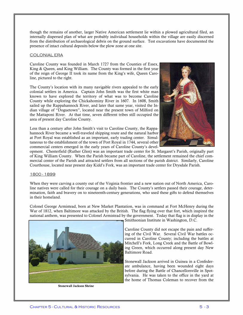
Colonel George Armistead, born at New Market Plantation, was in command at Fort McHenry during the War of 1812, when Baltimore was attacked by the British. The flag flying over that fort, which inspired the national anthem, was presented to Colonel Armistead by the government. Today that flag is in display in the
Smithsonian Institute in Washington, D.C. Caroline County did not escape the pain and suffer-ing of the Civil War. Several Civil War battles oc-curred in Caroline County; including the battles at Mitchell’s Fork, Long Creek and the Battle of Bowl-ing Green, which occurred along present day New Baltimore Road. Stonewall Jackson arrived in Guinea in a Confeder-ate ambulance, having been wounded eight days before during the Battle of Chancellorsville in Spot-sylvania. He was taken to the office in the yard at the home of Thomas Coleman to recover from the
Stonewall Jackson Shrine

CHAPTER 5 - CULTURAL & HISTORIC RESOURCES 5 - 4
amputation of his left arm. His wife, Julia, and newborn daughter were with him for his last four days of his life before succumbing to pneumonia. For more information on the Stonewall Jackson Shrine visit the Na-tional Park Service Website at http://www.nps.gov/frsp/js.htm Caroline County was traversed by both Union and Confederate forces during the Civil War and as a result, substantial parts of the County suffered great damage and destruction from battles, skirmishes and from the policy of “scorched earth”, where soldiers took everything they could carry and destroyed what remained, practiced by both armies. Confederate General Ambrose Powell Hill was a Virginia native, who distin-guished himself as a commander during the Civil War. He died before his fourteenth birthday during the siege of Petersburg. Today, the military training base in the northeastern portion of the County bares his name.
John Wilkes Booth, President Lincoln’s assassin, escaped out of Washington, D. C. to south of Port Royal, where he was killed on April 26, 1865, by the Union Cal-vary forces that had pursued him to Garret’s farm outside of Port Royal. Dramatic changes took place in Caroline County after the war as the Industrial Revolution began. New businesses and mills sprung up throughout the County. One of these was Rolph’s Mill in Sparta, which used the water from the millpond for power. The RF&P Railroad had a depot in Milford where passengers fre-quented Blatt’s Store, located next to the tracks. Later, the railroad constructed a passenger depot and a large water tank, which drew water from the Mattaponi River. During the age of steam locomotives Milford became an important water station. Another business enterprise at this time was the Elliott Brothers’ Shop near Bowling Green, now a part of the A.P. Hill military reservation, which offered various services to buggies, stagecoaches and wagons.
1900 - 1919
On April 10, 1900, a fire broke out in Bowling Green. At this time, there was no organized fire department in the Town. The Lawn Hotel and other buildings were saved by placing wet blan-kets on the roofs to protect the structures from the flames and heat. Residents worked together using any buckets and containers that could hold water to put out the fire. By the time the fire had been brought under control, the entire business district of Bowling Green had been destroyed, burning approximately 35 buildings. Immedi-ately following the fire, residents began rebuild-ing the Town. Many other important business events happened during this time, including the initial organiza-tional meeting for Caroline County Bank (now Union Bank & Trust), a new telephone company was established to serve the County and Bowling Green Power & Light Company was formed. Before adequate school facilities existed in Caroline County, children rode the train to Ashland and Rich-mond to attend school. One of the first school groups to organize was in Sparta where residents met in Sa-lem Church to organize a community high school. Following this meeting, the first high school opened in Caroline County for 68 students. In 1918 Sparta High School became the first to have an organized Home Economics and Agricultural Department. This was the first educational facility in the state to be built and furnished by the community without any outside help.
John Wilkes Booth
Bowling Green after the 1900 fire

CHAPTER 5 - CULTURAL & HISTORIC RESOURCES 5 - 5
1920 - 1949
In 1932, an Emergency Relief Committee, set up in response to the Great Depression, determined that $200 a week in aid was needed to assist 100-families in dire circumstances. In 1933, a $20,000 road project began on Route 38 between Port Royal and Rappahannock Academy. This project provided 30 to 40 jobs for men accomplishing work on public school buildings, the firehouse, sidewalks in Bowling Green and Milford, wa-ter works and sidewalks in Port Royal and work on courthouse lots. Fortunately, home food production for many of Caroline’s residents during the 1930s was possible. During this time, traditional money crops such as lumber and tobacco, sweet potatoes and cumbers were added to the mix of agricultural products raised in Caroline. As a result of this growth, agricultural associations were formed and storage houses were built that helped the economic growth of the entire County. Additionally, electrification of rural areas of the County began under the Rural Electrification Administra-tion. A farmer’s Rural Utilities Corporation was created, the first one formed on the Atlantic Seaboard. On August 13, 1936, rural electric service arrived in Caroline.
On March 18, 1941, the United States mili-tary established a training area in the north-eastern quarter of Caroline County. This facility was to serve as a training area for the U.S. 1st Army. Many families, farms, schools, churches, cemeteries, gristmills, storage houses, and stores were displaced. The Civilian Conservation Corps (CCC) trucks were made available to assist in mov-ing the families from their homes that be-came part of the Army training ground. For those families who could not find or afford new dwellings, the Farm Security Admini-stration arranged for them to rent small-prefabricated homes through the end of the War. In June of that year, the first field ex-ercises were held on the military reservation. In October, construction of a USO recrea-tion center occurred in the Town of Bowling Green. Later this structure was acquired by the Town and now serves as Town Hall for
Bowling Green. A second USO facility was constructed for African Americans in the location of the present day Caroline County Cannery.
1949 - TODAY
On April 10, 1955, a fire again swept through the business district of the Town of Bowling Green. This fire is believed to have started in a barn on Easter Sunday. It was exactly 55 years after the first Town fire. As in the 1900 fire, prisoners were released from the jail to help assist in fighting the fire as well as twenty-five (25) fire companies were dispatched. More than two dozen buildings were destroyed by the fire,
One of many farmhouses taken over by A.P. Hill
1955 Fire in Downtown Bowling Green

CHAPTER 5 - CULTURAL & HISTORIC RESOURCES 5 - 6
causing an estimated one million dollars in damage. Within a year the Town had rebuilt and celebrated a Grand Re-opening Day. Since the grand reopening day of Bowling Green, many changes have occurred in Caroline County. New interstate highways were constructed to connect Caroline with urban areas to the north and south, schools were consolidated and integrated, a water system was constructed in Milford, a community center was con-structed in Dawn and the Courthouse was renovated. Even with these vast changes, Caroline County still maintains its agricultural roots. With the new transportation links (I-95), Caroline agricultural products have the opportunity to be exported to other markets. In response to these many changes, a manual was published in March 1988 by the Board of Supervisors, enti-tled A Hand-Book of Caroline County, to outline the advantages of living in Caroline County and desires of the County residents . The manual generally stated that the citizens of Caroline County desire their County to be in the forefront of Progressiveness and extend an invitation to anyone who seeking a home, to invest and become part of the community.
TRANSPORTATION
The historical development of Caroline County is tied closely to the predominant transportation mode at the time. From its discovery in the early 1600’s to the mid eighteenth century, colonists re-lied on navigable rivers, most notably the Matta-poni and Rappahannock Rivers as their means of travel and trade. The Rappahannock River became a well-traveled shipping route and Port Royal de-veloped into an important trading center. The first major road through Caroline County was the Kings Highway running from Fredericksburg, through Sparta, down to King William Courthouse and eventually to the colonial capital of Williams-burg. The road system continued to develop into a network of tobacco rolling roads or stage coach roads, superseding the Kings Highway. One of the most important tobacco road developments was the es-tablishment of the Stagecoach Road in 1742. Stagecoaches carrying mail and passengers traveled this route frequently to and from Richmond. The two main rolling roads were the Chesterfield and Needwood Roads, which converged at Port Royal. Taverns and ordinaries, such as The Grove, emerged along the road at inter-vals of five to ten miles and became important commercial and social centers.
The Richmond, Fred-ericksburg and Poto-mac Railroad (RF&P) was chartered on Feb-ruary 25, 1834 for the purpose of construct-ing a railroad from Richmond to the Poto-mac River. The rail-road reached Caroline County in 1836 and the first station was opened in Chesterfield (Ruther Glen) on June 15, 1836. The railroad
Milford Station, 1940—William Griffin Photo
The Grove

CHAPTER 5 - CULTURAL & HISTORIC RESOURCES 5 - 7
established five freight and passenger stations in Caroline County at Ruther Glen, Penola, Milford, Wood-ford and Guinea.
The largest and longest surviving of the stations was in Milford. Major passenger and freight stations were constructed at Milford in 1891 and 1892 respectively. Buoyed by large movements of troops and materials, both the freight and passenger stations were extremely busy through World War II. At one time, Milford boasted a modest yard and rail sidings to serve local industries. A number of commodi-ties were shipped into or out of Milford, including pulp wood, lumber, fertilizer and feed. Many important shippers had their own private sidings due to the volume of business, including DeJarnette Lumber Com-pany, Alliance Fertilizer, Georgia Pacific, Jones Chemical, Keller Industries and Hoover Wood Treated Products. The RF&P also had a local station track to serve less frequent customers, including Callao Feed Service, Caroline Fertilizer, Southern States, Virginia Electric Cooperative and the Virginia Department of Transportation. While local freight service remained relatively strong, passenger traffic quickly declined following the end of war and by 1950, Milford was only a stop for local passenger trains. In 1955, the State Corporation Commis-sion gave the railroad permission to close the passenger station, which was demolished that same year. The freight station remained active until 1973, when it closed and its functions were transferred to other locations. The road network that the railroads replaced in the mid 1800’s, came back to replace the railroads in impor-tance by the mid twentieth century. Improved roads, including Route 207 and of Interstate 95 took not only passengers, but eventually much of the freight traffic handled in Milford.
HISTORIC FIGURES
Caroline County is associated with several important men in the nation’s history. James Taylor “The Elder”, owned several thousand acres which stretched from Piccardee’s Fork through Sparta and parts of King & Queen County. He named his plantation Hare Forest after his family’s estate in England. James Taylor, “the Elder” was the ancestor to several important men in our nation’s history; John Penn, Judge Edmund Pendleton, James Madison, Zachary Taylor Robert E. Lee, Jefferson Davis many others. He died on April 30, 1698, and was buried on his property (Hare Forest) in Caroline County. John Penn, who was born in Caroline County, and was one of the signers of the Declaration of Independ-ence, as were John Taylor and Judge Edmund Pendleton, were all from the County. John Taylor served as an officer in the army during the Revolution and held many political positions. Taylor is also known as the Father of modern American agriculture and wrote several books on the subject. Edmund Pendleton, Chair-man of the Virginia State Convention to ratify the Constitution, has been named “Caroline’s Most Distin-guished Son”, was an important personality in the shaping of the country.
Guinea railroad tracks and passenger station (right) in the 1920s

CHAPTER 5 - CULTURAL & HISTORIC RESOURCES 5 - 8
Pendleton also served as the Speaker of the House of Delegates under the new Constitution and called the first Virginia Convention; headed the Judiciary Department of Virginia for 15 years; was a member of the team to revise the laws of Virginia, in collaboration with George Wythe and Thomas Jefferson, when independence was declared; served as a judge of the United States District Court of Virginia, as appointed by George Washington; and was a leader of the Federalist Party of Virginia until his death. His home Edmundsbury was an intriguing one and one-half-story frame house from the eighteenth century. His home was lo-cated near the first Court House of Caroline County. The house burned in 1931. Another important Caroline resident was George Rogers Clark, who came to live in Caroline in 1757, and re-mained until 1784. Clark is known especially for having driven the Brit-ish from the Ohio Valley in 1778, and saved the Midwest for the United States. Clark’s younger
brother, William Clark, was born in Caroline in 1770, and lived in the County until 1784. In command of Meriwether Lewis, Clark led the fa-mous expedition in 1803 to 06 to the mouth of the Ohio River and back. Ben York, a manservant of William Clark accompanied Clark on the ex-pedition. He played a critical role in getting cooperation from Native Americans encountered on the expedition. Caroline was the first county in Virginia to cut her ties with Great Britain. Under Pendleton’s leader-ship, the county officials renounced the Crown and swore allegiance to the Commonwealth on July 11, 1776.
CEMETERIES
Several cemeteries in Caroline County have historical significance. Table 5.1 lists historic cemeteries associ-ated with churches in the County and Table 5.2 lists known private, historic cemeteries. Identifying historic cemeteries is an ongoing effort by the County. One of the most important cemeteries is Hare Forest. Taylors and Pendletons were buried there more than 300 years ago. The cemetery is located on the Hare Forest Plantation originally owned by James Taylor “the Elder”. The plantation and cemetery are named after James Taylor’s family estate in England and is still owned by one of his descendents, Major William Pendleton.
George Rogers Clark
Edmond Pendleton

CHAPTER 5 - CULTURAL & HISTORIC RESOURCES 5 - 9
Table 5.1 Church Cemeteries
Cemetery Name Location Size (in acres)
Long Branch Baptist Church Long Branch Road Unknown
Grace Episcopal Church Route 2 and Pepmeier Hill Road Unknown
Round Oak Baptist Church Pepmeier Hill Road Unknown
Port Royal Memorial Baptist Church
Port Royal Unknown
St. Peters Episcopal Church Port Royal Unknown
Shiloh Baptist Church Port Royal Unknown
Shiloh Baptist Church Port Royal Unknown
St. Mary Cemetery Route 626 2
St. Mary's Hall Paige Road Unknown
Countyline Baptist Church Ladysmith Road 13.56
Mt. Zion Seals Road 5.41
Ruther Glen Congregation of Je-hovahs Witnesses
Rogers Clark Boulevard Unknown
Grace Baptist Church Sparta Road Unknown
Salem Church Sparta Road Unknown
Jerusalem Baptist Church Bagby Road Unknown
St. Stephens Church Route 630 2.42
Unknown Sparta Church Road Unknown
Oxford Mt. Zion Baptist Church Zion Road 1.14
Jericho Baptist Church Jericho Road 1
Carmel Baptist Church Route 1 & Jericho Road 1
St. Margaret's Episcopal Church Route 652 Unknown
St. Pauls Methodist Church Sunshine Road Unknown
Reedy Church Dry Bridge Road Unknown
Mt. Oni Baptist Church Dry Bridge Road Unknown
Mt. Tabor Baptist Church Mattaponi Trail Road 4.6556
Mt Hermon Baptist Church Mattaponi Trail Road 3
Bagby Mattaponi Trail Road 1.24
Mt. Vernon United Methodist Church
Frog Level Road Unknown
Mt. Zion Baptist Church Old Dawn Road Unknown
Mt. Horeb Baptist Church Route 600 1.71
Chapel Cemetery Ladysmith Road Unknown

CHAPTER 5 - CULTURAL & HISTORIC RESOURCES 5 - 10
Table 5.2 Private Cemeteries
Cemetery Name Location Size (in acres)
Conway Old Grain Road 0.545 Flintshire Route 17 Unknown
Unknown Macedonia Road Unknown
Unknown Long Branch Road Unknown
Unknown Route 668 Unknown
Unknown Route 668 Unknown
Steven Family Route 17 Unknown
Unknown Route 17 0.59
Unknown Hazelwood Lane Unknown
Unknown Hazelwood Lane Unknown
Unknown Hazelwood Lane Unknown
Cora Carter Family Graveyard Route 606 Unknown
Guss Family Mem. Cemetery Route 607 0.47
Macedonia Cemetery Route 607 Unknown
Unknown Route 607 Unknown
Mt. Lawn Cemetery Route 626 Unknown
Unknown Route 2 Unknown
Unknown Route 2 Unknown
Unknown Route 742 1
Greenlawn Cemetery and Chapel Lakewood Road 39.04
Bowling Green Cemetery Co. Lakewood Road 5.5
Walter May Vaughan Tract Route 625 1.25
Lake Land' Or Land'or Drive 0.1
Unknown Route 633 Unknown
Unknown Route 601 Unknown
Beasley Cemetery Perimeter Road Unknown
Haynes Locust Hill Road Unknown
Rollins Cemetery Route 618 Unknown
Unknown Route 738 Unknown
Providence Cemetery Route 721 Unknown
Unknown Route 643 Unknown
Old Salem Cemetery Route 618 Unknown
Unknown Route 630 Unknown
Unknown Route 630 Unknown
Unknown Route 700 Unknown
Unknown Route 659 Unknown
Iola M. Freeman Estate Route 693 Unknown
Unknown Route 693 Unknown
Unknown Route 670 Unknown
Unknown Route 600 Unknown
Newtons Quarters Road Unknown
Unknown Route 672 Unknown
Unknown Route 643 Unknown

CHAPTER 5 - CULTURAL & HISTORIC RESOURCES 5 - 11
TOWNS & VILLAGES
Although much of the early settlement in Caroline County occurred in isolated pockets as farms and planta-tions, more concentrated developments emerged along the Rappahannock River and at commercial cross-roads. Planned towns, such as Port Royal and Bowling Green, were specifically laid out in response to resi-dents’ demands and legislative decree. Other villages in the County began as stops on the railroad and even-tually grew to include residential, commercial and industrial buildings. BOWLING GREEN
The Town of Bowling Green is centrally located within the County at the intersection of Routes 301 and 207. It was originally called “New Hope”, but within a century of it’s founding was referred to as “the Bowling Green”, because of its association with the plantation house built by Ma-jor Thomas Hoomes. This house, later known as “Old Mansion”, was built on a tract of land Hoomes acquired in 1667-70 upon his departure from England. The mansion and its land became quite a social center, offering a bowling green, and hosting a number of horse races and other eques-trian activities. Bowling Green was established as the county seat, and a frame Courthouse building was erected in 1833-35 and is now across the street from the present day courthouse. Shortly after Bowling Green’s establishment as the county seat, the Richmond, Fredericksburg & Potomac Railroad (RF&P) was built and a station erected in Milford, two miles west of Bowling Green. Two bus lines connected the railroad station to Bowling Green. DAWN
Dawn is centered at the intersection of U.S Route 301 (Richmond Turnpike) and State Route 30 (Dawn Boulevard). It has its begin-nings in pre-colonial days with at least two In-dian Villages. One village near the Pamunkey River at what is now known as North Wales Farm (Cattachiptic), and the other behind what is now Bethel United Methodist Church on Route 30 (Myghtuckpassau). There were plantation owners, homesteaders, free blacks, slaves and indentured servants anx-ious for land settled the area after the Treaty of 1677 with Queen Ann of the Cattachiptic. The free blacks were a result of the Treaty, which stated no Indian shall be held as a slave. This
was interpreted to be all children born of a black woman who had Indian blood, therefore, all blacks with Indian blood were free. The Dawn area was settled by men anxious for land, which was allowed when Queen Ann of the Cattachip-tic Indians made a treaty with the colonists in 1677, however the name Dawn did not appear until 1889. Dawn was a busy place before and after the Civil War, with a general store, a brick yard, a tanyard, a shoe shop, a flour mill and several taverns and stages (stage coach stops).
Caroline County Courthouse
Bethel United Methodist Church

CHAPTER 5 - CULTURAL & HISTORIC RESOURCES 5 - 12
GUINEA
Situated on the RF&P railroad towards the eastern edge of the County, Guinea is a small residential enclave near the intersection of Stonewall Jackson and Guinea Station Roads. The recent reconfiguration of the roads resulted in Guinea being located on a dead end stretch of road, isolating it somewhat from traffic. The Community has been called various names throughout history, including, Guinney’s Bridge and Guinea Station. Despite the variations, all of the village names undoubtedly originated from the Michael Guinney who, in 1704, homesteaded 210-acres on the upper branches of Goldenvale Creek. As a small village with a stop on a rail line, Guinea was home, during the late nineteenth and early twentieth centuries, to several stores, a church, gristmill, blacksmith forge, sawmills, a lumber company, and many single-family dwellings. One commercial structure from this era remains, as well as some of the residential structures and the church. LADYSMITH
Ladysmith was named in 1928 by Miss Clara L. Smith. She chose this name, partly because of her own name and partly due to a town she read about in a magazine near some diamond mines in South Africa. Clara Smith was born in Landor, a house build in 1787 by William Guiney near present-day Ladysmith. She was the daughter of Sallie Collins and Captain C.T. Smith, the first president of the Caroline Chapter of the United Daughters of the Confederacy and a Confederate War hero, respectively. Clara Smith had a vision for the town she called Ladysmith and commissioned the platting of a parcel of land on Old Telegraph Road on which it was to be placed. Though her project was never realized, the name of Ladysmith remained with the area.
MILFORD
Located two miles west of Bowling Green, just north of the Mattaponi River and situated on the RF&P Rail-road, Milford became an important transportation center during the nineteenth century. The town was estab-lished in 1792, when an act was passed by the Virginia Assembly “To establish a town and inspection of tobacco on the lands of John Hoomes in the County of Caroline.” The Mattaponi River was navigable and shipments were sent from Mil-ford down the river. Almost two centuries prior to estab-lishment of this tobacco inspection station, the area around Milford was known as Doguetown to the first colonial settlers of Virginia. Dogue-town was the upper head of naviga-tion on the Mattaponi and was con-trolled by the Dogue Indians. In 1655, Major William Lewis platted 2,000-acres in the upper part of the river area, near where the Milford is now located, and by 1678-80 a fort was erected there. Settlement in that area continued to include many private forts erected as protection from raids by nomadic Indians. The last known reference to Indians in Doguetown appears in 1720 when the Virginia Council granted 1,000 acres of land on May’s Run. Although much of its late nineteenth and early twentieth-century commercial and railroad architecture lies abandoned, Milford stands today as an important intersection in the County’s network of roads and indus-trial properties.
Milford Freight Station in 1968

CHAPTER 5 - CULTURAL & HISTORIC RESOURCES 5 - 13
PENOLA
Also situated along the RF&P rail line is a small crossroads community at one time consisting of several stores, flour, and excelsior mills, as well as private residences. Originally called Polecat Junction, for Polecat Creek which runs nearby, the station and village became known as Penola by 1864, according to its name label on the 1864 Gilmer map of Caroline County.
PORT ROYAL
Located on a natural harbor on the south side of the Rappa-hannock River in Caroline County, the Town of Port Royal was chartered in 1744 by an act of the House of Burgesses. The Act called for the establishment of a town near Roy’s Warehouse in the County of Caroline. Roy’s Warehouse, a tobacco warehouse situated approximately 300 yards north of the present site of Port Royal, was acquired by John Roy in 1714. By the early 1740s, significant numbers of ships were using the harbor at the Port Royal site, settlers were clustering around the tobacco warehouse, and the area was becoming a small, but thriving transportation and commer-cial center. The Act establishing the Town of Port Royal emerged not only in response to the increased activity and population at the site, but in answer to a petition entered to the House of Burgesses on September 21, 1744. The petition was entered by Elizabeth Smith, whose deceased husband’s will had or-dered sixty (60) acres of land, lying near Roy’s Warehouse, to be laid out for a town. In 1743, in preparation for the establishment of the Town, Richard Taliaferro authorized Robert Brooke, a well-known surveyor and mapmaker in Virginia, to survey the sixty acres of land. Brooke’s survey resulted in a town plan consisting of 84 one-half acre lots divided by streets running orthogonally creating a grid pattern. Throughout the eighteenth and early nineteenth centuries, Port Royal enjoyed a large tobacco trade with England and survived as a flourishing river port. With the introduction of the railroad through Caroline County in the mid-nineteenth century, Port Royal’s importance as a commercial town diminished. Today, Port Royal and its remaining eighteenth-century architecture are suffering from development pressure.
SPARTA
On July 2, 1802 a group from Upper King and Queen and Upper Zion (Tuckahoe) Churches met and wrote a one-page covenant forming Salem Bap-tist Church (pictured to the left). This body of be-lievers met in an arbor until a wooden frame build-ing was constructed about two miles southwest of Alps. In 1818, another group started Mount Calvary Church at Sparta. These believers met in a large log house until it was replaced with a brick struc-ture in 1852, which is the present-day sanctuary.

CHAPTER 5 - CULTURAL & HISTORIC RESOURCES 5 - 14
At the end of the Civil War, members of Salem helped their black members establish Jerusalem Baptist Church, about two miles south of Sparta. In 1869, members began to use the better meetinghouse in Sparta exclusively and three years later the name was changed from Mount Calvary to Salem. In 1912 Sunday school rooms were added. Though renova-tions have occurred through the years, great care was taken to preserve the 19th century character of the original building.
WOODFORD
Located between Guinea and Milford on the RF&P rail line, Woodford was one of five early railroad sta-tions to serve the County and known from the earliest times as Woodslane. By 1874, the post office was known as Woodford and the designation was given to the station. The name Woodford was in honor of the Woodford family from Windsor, a house located on the Rappahannock River about ten miles south of Fred-ericksburg. General Woodford, the son of Major William Woodford, who came to Caroline County from England toward the end of the seventeenth century, gained fame in the County for his services rendered dur-ing the American Revolution, as one of George Washington’s generals. Woodford consists today of a series of vacant commercial and railroad-related buildings clustered around the railroad tracks, as well as a handful of presently occupied residential buildings.
Additional information on many of the areas can be found in the Community
Plans.

CHAPTER 5 - CULTURAL & HISTORIC RESOURCES 5 - 15
SCHOOLS
As in any community, education of the community’s youth is imperative. In the earliest days of Caroline County, most children learned to read and write at home from their parents. With development of the rail-road, many Caroline students rode trains to attend schools in Richmond or Ashland. Like many communities, the earliest ef-forts to establish a school began with pri-vate citizen donations and help. Mr. Reuben Rolph I of Sparta constructed the first community school in Caroline in 1858. In 1867, the Home School for Girls was opened in Bowling Green with ten female students. Enrollment grew rapidly since there were no free public schools at the time and the school was moved to the Lawn Hotel in 1870 and in 1872 to Mil-ford Street to allow for more space. At this time, they changed the name of the school to Bowling Green Female Semi-nary. In 1889, the school house burned and was replaced by a schoolhouse with eight classrooms. Tuition, board, lodging, & laundry was $125 per semester. The school closed in 1901. The Rappahannock Academy building, located on the grounds of Fort AP Hill, was constructed around 1870 and served the community until the 1920’s after County high schools existed.
Around 1908, Caroline citizens began meeting at the Salem Church in Sparta to consider build-ing a community high school. In the fall of 1909, Sparta High School opened with 68 students and Mr. D. N. Davidson as its principal. Not only the County’s first high school, this school was unique because it was the only one in Virginia to be built “by the citi-zens of the community without any outside help whatever, completely furnished with desks and stoves and presented as a gift to the school board.”
Bowling Green Seminary students around the Milford Street school building
Sparta High School

CHAPTER 5 - CULTURAL & HISTORIC RESOURCES 5 - 16
CHURCHES
Historic records indicate that there were sixteen churches in the County, including Quaker, Episcopalian, Baptist, Methodist and Presbyterian.
In 1739, Quakers began a settlement in the Golansville area that would last 114 years. John Penn, signer of the Declaration of Independence, was born in this settlement in Caroline County. As in many of the emerging ideals of American revolution, religious freedom was recognized as a personal right. In 1771, six Baptist ministers were impris-oned in the Caroline County Jail for “unlawfully assembling themselves to teach or preach the gospel in other manner than according to the liturgy of the Church of England.” Although they were whipped and fed bread and water, the pris-oners were given such a bounty of food by their captors, they were able to provide for the poor outside of the prison. Ultimately, the six were released and established churches in Carmel Church, Bethlehem, Upper Essex and King and Queen.
Churches became the community centers for the areas they served, such as Salem Baptist Church in Sparta, and helped to establish many of the towns and villages in the area. POSTAL SERVICE
In 1736, Head Lynch began providing stagecoach service to Caroline County and obtained authority to con-struct a road from Needwood Tavern, located in southern Caroline County, to Aylett. With stage coach ser-vice, Mr. Lynch was also able to provide mail service and became the County’s first postmaster until his death in 1743. As rail service became es-tablished, mail service con-tinued to expand at each station. The station master would hang bags of mail to be pickup and the train con-ductors would provide bags to be delivered. These drop offs did not require full stops and permitted rela-tively quick and inexpen-sive delivery of mail and goods. Today, there are nine post offices in the County: Bowling Green, Corbin, Ladysmith, Milford, Port Royal Rappahannock Academy, Ruther Glen, Sparta and Woodford.
Saint Peter’s Episcopal Church in Port Royal
Original Milford Post Office (left) and existing Milford Post Office on dedication day in 1961 (right)

CHAPTER 5 - CULTURAL & HISTORIC RESOURCES 5 - 17
PRESERVATION EFFORTS
HISTORIC REGISTER
To date, the preservation efforts of historically significant properties in Caroline County have been limited to the efforts of individual property owners with some assistance from the Historical Society and Mary Wash-ington College. Current preservation efforts will result in far fewer sites, structures, and areas being preserved than could be achieved with a well organized, cohesive effort involving County citizens, local, and state gov-ernments. Although the preservation efforts have lacked cohesiveness, the efforts of the individual property owners have been impressive. Nineteen individual properties are listed on either the Virginia or National Register of His-toric Places. The Caroline County Courthouse and the Town of Port Royal are represented, as well as two sites in Fort A.P. Hill. The list of properties on the registers are identified in Table 5.3. In a recent survey of historic resources, over seventy historic properties were identified as having been de-stroyed or lost over the past fifty years.
Table 5.3 Properties on the Virginia/National Historic Register
Name Location Date Constructed
Acreage Register Date
Auburn Hill Bowling Green 1843 10 2006
Camden Port Royal 1857 26 1969
Bowling Green Historic District
Bowling Green -- -- 2003
Caroline County Courthouse
Bowling Green 1830 2 1973
Edge Hill Woodford 1820 332 1983
Gay Mount U.S. Routes 17 & 301
1800 300 1972
Green Falls VA Route 627 & 623
18th Century 62 1997
Jericho School VA Route 658 1917 1 2004
Liberty Baptist Church Fort A.P. Hill 1850 9.5 1996
Moss Neck Manor VA Route 766 1856 100 1999
Old Mansion Bowling Green 1670 127 1969
Port Royal Historic District
Port Royal -- -- 1970
Prospect Hill U.S. Route 17 1842 15 1976
Riverview Port Royal 1845-46 1 1994
Santee Corbin 1817 270 1979
Spring Grove Sparta 1856 396 1976
Townfield Port Royal 1744-79 2 1994
Travis Lake Historic District
Fort A.P. Hill -- 150 1996

CHAPTER 5 - CULTURAL & HISTORIC RESOURCES 5 - 18
The 1987 Update to the Comprehensive Plan recognized the need to identify and preserve historically signifi-cant properties. Responding to this need, the County, in conjunction with the Virginia Department of His-toric Resources, undertook a survey of historic resources. The 1991 survey was conducted by PMA Consult-ing Services and Traceries (PMA) and concentrated on the Primary Growth Area and the Dawn, Guinea, Port Royal, Sparta and Woodford Secondary Growth Areas. PMA surveyed over two hundred properties, identified based on the recommendation of local citizens, evaluations of files at the Virginia Department of Historic Resources of previously surveyed sites, and a sys-tematic survey of sites fifty years or older. Based upon this survey, forty-five sites were identified for the Na-tional Register of Historic Places and classified into one of three categories; potentially eligible properties, potentially eligible properties but requiring additional research, or potentially eligible properties which are threatened by demolition, deterioration or incompatible developments. The breakdown of these properties by category is shown in Table 5.4. These properties are only a partial list of potentially eligible properties. As other areas of the County are sur-veyed, more sites will be identified. This list should be maintained as additional historic surveys are con-ducted in order to keep a current inventory of potentially eligible sites.
Table 5.4 Potential Sites Eligible for Virginia/National Historic Registration
Potentially Eligible Additional Research Needed Threatened
Blenheim Glamorgan Hubbard’s Tavern
Elson Green Hampton Manor Todd’s Tavern
Grace Episcopal Church Hayfield Woodford Depot
The Grove Locust Hill Old Brick House
Mount Gideon South Brook Milford Freight Depot
Stanhope White Plains Blatt’s Store
Mulberry Place Hillford Chandler House
Cook’s Mill Mount Zion Broad Plain
Bethel Baptist Church Belle Hill
New Market Plantation Ivy Hill
Mount Clear
Cannon Place
Marmuduke
Fontaine Hill
Popular Grove
Thompson’s Hill
Caroline Mansion
St. Margaret’s Episcopal Church
Milford Bank

CHAPTER 5 - CULTURAL & HISTORIC RESOURCES 5 - 19
Map 5.1—Historic Resources Map
Map 5.1 identifies the general location of known historic resources within the County. This map includes those sites listed on the Virginia Historic Register.

CHAPTER 5 - CULTURAL & HISTORIC RESOURCES 5 - 20
AUBURN HILL
Built circa 1843 for Clerk of Circuit Court, Robert Hudgin, Auburn is located in the town of Bowling Green. This dwelling is the northernmost house within the town limits and continues to maintain its rural setting. It began as a two-story house with a single-pile, side-passage plan, built during a period when Bowling Green was becoming estab-lished as a small courthouse town. The various owners of Auburn expanded the house as the economic, social, and technological developments took place throughout the late nineteenth and early twentieth centuries. The transition of popular architectural styles on a local and vernacular level is also seen in the construction of this house. Some architectural elements are characteristic of the Georgian style, while the house mostly reflects the Greek Re-vival style. All additions are historic and maintain the overall style and integrity of the house. The house re-tains its overall character-defining architectural elements as well as its setting. This house is on the National Register for its local significance as an example of vernacular building traditions, principally in the Greek Revival style.
CAMDEN
Camden was built between 1857 and 1859 for Wil-liam C. Pratt on the site of a previous frame resi-dence on the bank of the Rappahannock River near Port Royal. Camden is one of the most fully devel-oped examples of the Italian Villa style of architec-ture, which captured the spirit of mid-19th Century America. The house is marked by broadly project-ing eaves supported by a strongly scaled bracketed cornice and wide semi-circular verandahs and con-servatory. The top level of the tower was shot off by a gunboat in the Civil War and was never re-placed. The original architectural drawings, by English-born Nathan G. Starkwether, survive in the house today. Many of the original furnishings and fixtures remain with the house still.
CAROLINE COUNTY COURTHOUSE
Caroline County Court House is a significant member of a group of early nineteenth century Virginia court houses, whose designs were inspired by the work of Thomas Jef-ferson. Not only does the building incorporate elements of Roman architecture, but certain features are taken di-rectly from known works of Jefferson. This is particularly evident in the arcade which employs similar proportions as those on the Ranges at the University of Virginia. Ga-ble-end façades, as seen on the Caroline County Court-house, with an arcade on the ground level were common features of Renaissance town halls in England. Because of the destruction of the Caroline County records, the builder and construction date of the court house is un-known, but it is estimated to have been constructed around 1830.

CHAPTER 5 - CULTURAL & HISTORIC RESOURCES 5 - 21
EDGE HILL
Located on the edge of a bluff overlooking the bottomlands of the Matta River, Edge Hill contains two his-toric buildings: a Federal plantation dwelling and an antebellum academy building. The house, a representa-tion of the region’s rural Federal architecture, was built in two sections. The earliest section dates from 1820-21 and was build for Rice Schooler, who had the house enlarged in 1840. The addition was of the western
half, giving it a formal, symmetrical five-bay façade. The house is notable for the highly individualized Federal woodwork in the old-est section of the house, which contains provincially interpreted Adam-style motifs. The whole structure is a good document of regional building techniques of the 1820s and 1840s. The academy building was erected in 1857 by Rice Schooler’s son, Samuel Schooler. Known as Edge Hill Academy, the private boys’ school was founded by Schooler to meet the growing demand of Virginians wanting higher education. Although the Academy closed in the late 1860s, the build-ing, now preserved as a bar, survives as a
rare example of rural private school architecture of the antebellum period. The property also contains ar-chaeological sites of cabins related to the Academy and may have sites relating to the 18th-century occupa-tion of the property. GAY MOUNT
Gay Mont was built on a site overlooking the Rappahannock River in the latter part of the eighteenth century by John Hipkins (circa 1749-1804), a merchant of Port Royal, on land he had assembled between 1786 and 1799. At his death in 1804, Hipkins left this property, then called "Rose Hill, " to his only grandson, John Hipkins Bernard, then a boy of twelve. The estate was managed by Hipkins' widow who enlarged the original 976 acres to 1,417 and ran the plantation until her grandson reached the age of twenty-one in 1813. In 1816, Bernard married Jane Gay Robertson (1795-1852), daughter of William and Eliza-beth Bolling Robertson and changed the name of his seat to "Gay Mont" in honor of his wife. Two years later he departed for travels in France and was much impressed with French landscaping and ar-chitecture and took extensive notes as well as collecting seeds and plants that were sent back to Gay Mont. The influence of his travels could be seen in the formal gardens to the rear of the house with symmetrical walkways running between beds of shrubs and flowers. At the same time he enlarged the acreage of the plan-tation by 700 acres and added the two stucco, brick wings and the colonnade of Tuscan columns to the main house. At Bernard's death in 1858 three of his children purchased the house and 445 acres from the other heirs. One of these, Helen Struan Bernard, acquired the homeplace in 1865 after her marriage to her cousin, Philip L. Robb, grandson of John Hipkins Bernard's sister. Gay Mont remained in the hands of the Robb heirs until it

CHAPTER 5 - CULTURAL & HISTORIC RESOURCES 5 - 22
was sold in 1958. After the fire in 1959, it was brought back into the family by Mr. and Mrs. James S. Pat-ton, Mrs. Patton being a granddaughter of Mr. and Mrs. Philip L. Robb. Although severely damaged by fire, Gay Mont was gradually brought back to its former appearance. The grounds and gardens were rehabilitated, the house was rebuilt along its original lines, incorporating as much original material as possible and a large number of family furnishings have been returned. GREEN FALLS
Green Falls is considered by some historians to be the earliest surviving 18th-century frame dwelling in Caroline County. This claim cannot been substantiated through documentation because nearly all of Caroline County's colonial records were destroyed during the Civil War. Physical evidence suggests that its architectural form has changed very little since its last substantive addition in 1808. Green Falls retains the form, scale, and proportion of the modest rural Virginia plantation house of the colo-nial period. Its surviving original fabric is consistent with its alleged early construction date, and this fabric has not been compromised by later repairs and replacements. Green Falls continues to stand in its historic agricultural
surroundings, which showcases an example of the 18th century rural landscape. JERICHO SCHOOL
The Jericho School is an example of an early-twentieth century African-American school. It is representative of the late-nineteenth and early-twentieth century move-ment to educate African-American children in the United States. Built around 1917, it replaced an earlier log school, which stood on the same property. The Jeri-cho School is an example of a one-room school, a build-ing type that is becoming increasingly rare. It demon-strates the overarching influence of the Rosenwald Fund on school construction in early-twentieth century Ameri-can. Although apparently not built using Rosenwald funds, the Jericho School closely resembles a version of the one-teacher school plan outlined in Community School Plans, a Rosenwald Fund publication. The Jericho School offers a unique opportunity to explore the African-American educational experience in Virginia, as it served the African-American children of the area until the early 1960s, when the County opened the Union School for African-American children. LIBERTY BAPTIST CHURCH
Liberty Baptist Church is associated with one of the oldest Baptist meetings in Caroline County. The earliest reference to the church dates to 1796, with more formal organization following in the 1810s. The present church, a brick nave-plan building built in 1850, is a well preserved example of the churches built in the county during the ante-bellum period. The interior features Greek Revival detail and a slave gallery. From the Second World War to the present, the building has served as the Post Chapel for Fort A. P. Hill, and it is the only pre-1941 religious building to survive on the base.

CHAPTER 5 - CULTURAL & HISTORIC RESOURCES 5 - 23
MOSS NECK MANOR
The Moss Neck Manor residence house ranks with Virginia's best examples of Greek Revival plantation architecture. Built circa 1856 for James Parke Cor-bin, member of one of the Commonwealth’s oldest and most eminent landed families, house is a finely crafted mansion with a façade 225 feet in length, one of the longest in Virginia. The five-part composition reflects renascent interest in 18th century Palladian forms, here believed to have been directly inspired by Lanveille, the porticoed three-part Corbin family seat, built in the colonial period in King and Queen County. The exterior is set off by its proportions, columned verandas, and Flemish bond brickwork. A distinguishing feature is the octagonal cupola with its mulipedimented roof. Inside is a series of spa-cious reception rooms and bedrooms, most of which preserve original woodwork and marble mantels. Con-federate Stonewall Jackson used the plantation for encampment in the winter of 1862-63. In 1938 Moss Neck Manor was purchased by Theodore V. Houser, then a vice president of Sears, Roebuck & Co., who con-verted the long-neglected property into a prestigious country estate. OLD MANSION
Built circa 1670 on a land grant, the Old Mansion was originally called Bowling Green, taking its name from the large bowling green on the lawn. The name was changed to the Old Mansion when Major John Hoomes, the first owner, donated land for a courthouse and other public buildings, giving the name of his estate to the Town. The house had a race track around the lawn and became widely known for its stables. The Old Mansion served as an important social center for the area in the late eighteenth century. Among those entertained at the Old Mansion were General George Washington and some of his troops, who camped on the lawn, as well as Lafayette.
PROSPECT HILL
Prospect Hill was originally the country home of the prominent Falmouth merchant, Basil Cordon. The house is an example of provincial, mid-nineteenth century plantation architecture in the Tidewater re-gion of Virginia. Its Flemish-bond brickwork, fanlight doorway, and well-crafted interior trim all contribute to its eminence among buildings of its era. Because of the destruction of many of the records of Caroline County for the period between 1758-1845, little is known of the history of Prospect Hill. Originally part of the Battaile, and later the Fitzhugh lands, and thought to be the site of a predecessor of the present

CHAPTER 5 - CULTURAL & HISTORIC RESOURCES 5 - 24
house at Santee, an adjacent plantation, Prospect Hill became the property of Basil Cordon in the nineteenth century. His brother, Samuel Gordon, owned Santee, the acreage which surrounds Prospect Hill. By 1840, Basil Gordon had accumulated 930 acres of land, a holding which increased to over 1,200 acres three years later . An 1843 tax assessor valued his buildings at $4,000, of which $2,500 was noted as having been "added for new building," suggesting that the present house was built the previous year. Its form suggests a strongly conservative taste in design. The symmetrically molded door and window trim, the plain sandstone window lintels and some of the interior moldings are all concessions to the prevailing Greek Revival style . However, the proportions of the house, its high hipped roof, its use of Flemish-bond brickwork on all four sides, its el-liptical transom doorway, its use of Roman orders and many elements of its interior trim all recall the taste of at least twenty or thirty years earlier and give an impression of the detachment of this area from the fashion-able architectural modes of the mid-nineteenth century. RIVERVIEW
Riverview, built circa 1845-1846, exemplifies the living standards of a successful, yet modest, farmer with its simplistic Greek Revival style. It also repre-sents the last architectural style of Port Royal prior to an economic decline that struck the area with the replacement of steamboat travel by railroads. Be-sides being characterized by its strict double-pile plan, beaded clapboard, hip roof, and original exte-rior and interior trim, the structure commands an unobstructed view of the Rappahannock River. Since its initial construction, the structure has accu-mulated several additions, as well as damage from Union gunboats during the Civil War. The damage and additions, however, fail to diminish the architec-tural and historical integrity of the structure.
SANTEE
Santee, associated with the prominent Fitz-hugh and Gordon families for over 250 years, is an example of a formal plantation of early-nineteenth century Tidewater Virginia. The house, its early kitchen, stable, and slave house, and the verdant park present a glimpse of antebellum life along the Rappahannock River at its most prosperous. The land, which includes the present Santee, was pat-ented by John Battaile (circa 1660-1704), who emigrated to America around 1684. It passed to his son John II and then to John II's daughter, Sarah, who married Henry Fitz-hugh. Their son John Battaile Fitzhugh owned the property until his own death in 1803, when it passed to his brother, who cre-ated the present Santee plantation. In 1817, he added 166 acres to his holding, followed by another 300 acres the next year. Finally, in 1820, there was a separate valuation of the buildings, recording them as being worth $1700. Upon Fitzhugh's death, the property passed to his wife Elizabeth Taliaferro. In 1838, an increase in valua-tion occurred with the addition of two brick buildings, probably the kitchen and the stable, to the estate. Patsy Fitzhugh and her husband Samuel Cordon of Kenmore, in Fredericksburg, inherited Santee from her

CHAPTER 5 - CULTURAL & HISTORIC RESOURCES 5 - 25
mother. It was during their tenure, in the winter of 1862-1863, that a detachment of General Thomas "Stonewall" Jackson's troops camped in the Santee woods near the present road. Gordon was nervous about the safety of his park and reportedly elicited from the commanding officer a promise that the trees would not be cut for firewood. Descendants of the Fitzhugh and Gordon families owned Santee until well into the twentieth century. It was vacant from 1931 until 1943, at which time it was sold out of the family. SPRING GROVE
The Spring Grove plantation house is among Virginia's best-preserved domestic example's of the Italian Villa Style, popular throughout the country in the years just prior to the Civil War. Its monumental massing and detailing, prodi-gious size, plaster and woodwork, and graining and marbleizing all mark it as one of Virginia’s outstanding mid-nineteenth-century houses. The plantation has remained in the ownership of the family who built it and who have owned the property since the eighteenth century. The De-Jarnette family were reputedly Huguenot emi-grants in the late seventeenth or early eighteenth century. The present house, at least the third on the site, was built in 1856 by Daniel Coleman
DeJarnette, a scholar, a member of the Virginia House of Delegates and of the U.S. House of Representa-tives. DeJarnette also represented Virginia in the Confederate Congress. TOWNFIELD
Townfield, located on the Rappahannock River, is a good example of an evolutionary house, showing chang-ing trends in building styles. The original block, built in the mid-eighteenth century, displays high-style Geor-gian attributes and the 1823 and 1857 additions, both are designed in the Federal style. The first owner of Townfield, Robert Gilchrist, was a promi-nent member of the Port Royal community, main-taining his residence in the house until his death in 1790. First appearing in the Caroline County court records in 1747, he became a trustee of Port Royal, as well as a Caroline County Justice of the Peace, sheriff, and finally a Caroline County representative in the House of Delegates. In 1755, Gilchrist helped obtain a charter from the Grand Lodge of Scotland, to establish the Kilwinning Port Royal Crosse Lodge, the second Masonic lodge in Virginia. A wealthy merchant and ship owner, Robert Gilchrist served his community, from his home at Townfield, for his entire life. For additional information on these properties or other historic properties in Virginia, visit the Virginia De-partment of Historic Resources at http://www.dhr.virginia.gov

CHAPTER 5 - CULTURAL & HISTORIC RESOURCES 5 - 26
GOALS, OBJECTIVES, AND STRATEGIES
GOAL: IDENTIFY AND PROTECT SIGNIFICANT ARCHEOLOGICAL, ARCHITECTURAL, CULTURAL, AND
HISTORICAL RESOURCES FOR THE BENEFIT OF COUNTY RESIDENTS AND VISITORS.
OBJECTIVE 5.1- IDENTIFY SITES OF ARCHEOLOGICAL, ARCHITECTURAL, CULTURAL, AND HISTORICAL SIG-
NIFICANCE IN THE COUNTY. Action Strategy 5.1.1: Complete the Historic Architecture Survey of Caroline County. Phase I of the sur-vey covered the Primary Growth Area and selected Secondary Growth Areas. The survey of resources in the remaining Secondary Growth Areas and the rural areas of the County should be completed. Action Strategy 5.1.2: Establish and maintain a computerized listing of all architectural, cultural and his-torically significant sites. In developing the County's Geographic Information System, all culturally signifi-cant properties should be included with real estate and parcel identification to facilitate the identification, preservation and protection of significant properties. Action Strategy 5.1.3: Conduct Phase I and, if appropriate, Phase II and III, level cultural resource studies, as defined by the Virginia Department of Historic Resources. As development occurs, culturally significant properties may be destroyed. Applicants for rezonings and special exceptions should undertake such studies when appropriate and incorporate preservation techniques when appropriate. OBJECTIVE 5.2 - ENCOURAGE THE PRESERVATION OF ARCHEOLOGICAL, ARCHITECTURAL, CULTURAL, AND HISTORICAL RESOURCES THAT ARE IMPORTANT TO THE DOCUMENTATION OF COUNTY, STATE OR NA-
TIONAL HISTORY. Action Strategy 5.2.1: Assist property owners who desire to have their properties evaluated for inclusion in the Virginia Landmarks Register or National Register. The County should cooperate with The University of Mary Washington, the Caroline County Historical Society or other preservation groups to provide assistance to those property owners. Action Strategy 5.2.2: Encourage property owners of potentially eligible properties to seek designation in the Virginia and/or National Register of Historic Places. The County, in conjunction with the Caroline County Historical Society, GWRC (Planning District 16), or other groups should assist property owners of potentially eligible properties with their applications for such designation. Action Strategy 5.2.3: Encourage property owners to donate preservation easements for the protection of significant properties. In conjunction with the Virginia Department of Historic Resources, Virginia Outdoors Foundation, The Nature Conservancy or other appropriate organizations, the County should work with in-terested property owners to identify the benefits of voluntary preservation easements and encourage the use of such easements. Action Strategy 5.2.4: Promote the use of tax credits for rehabilitated structures. The County should en-courage the preservation of resources by encouraging property owners to use available Federal rehabilitation tax credits. Action Strategy 5.2.5: Develop an overall preservation plan for historically significant sites, areas and prop-erties. Sound recommendations and ideas were identified in the historic survey of Caroline County, all of which are not identified in this plan. A separate preservation plan should be considered to supplement the Comprehensive Plan and other County ordinances. OBJECTIVE 5.3 - ESTABLISH A FRAMEWORK THROUGH THE CAROLINE COUNTY ZONING ORDINANCE FOR THE PRESERVATION AND PROTECTION OF CULTURALLY SIGNIFICANT SITES FROM THE ADVERSE EFFECTS OF DEVELOPMENTS.

CHAPTER 5 - CULTURAL & HISTORIC RESOURCES 5 - 27
Action Strategy 5.3.1: Evaluate amendments to the Zoning Ordinance to include techniques to preserve significant resources. One of the best techniques available to local governments is the use of its zoning pow-ers to protect historic properties. The County should make use of its authority to provide opportunities for landowners to preserve historic resources. Action Strategy 5.3.2: Promote the preservation and protection of significant resources through the preser-vation of open spaces. View sheds and open spaces are integral components of historical properties in rural areas. These open spaces and view sheds should be recognized for their importance and protection measures should be included in the subdivision and zoning regulations. OBJECTIVE 5.4 - ENHANCE THE AWARENESS OF THE IMPORTANCE OF PRESERVING HISTORICALLY SIGNIFI-
CANT PROPERTIES FOR THE CITIZENS OF THE COUNTY. Action Strategy 5.4.1: Assist local historic preservation groups in promoting public awareness of preserva-tion issues. Action Strategy 5.4.2: Enhance the awareness of County history through the public school system. The school system offers a great opportunity to educate the younger citizens of the County and may lead to an increased level of awareness of historic preservation in future generations. Action Strategy 5.4.3: Encourage owners of historic properties to become involved with the Caroline His-torical Society or other local group to encourage others to preserve their properties and/or seek state and na-tional registration. Action Strategy 5.4.4: Promote local awareness and recognition of historic properties through open house tours, local landmark signage, driving tours, and brochures. Occasionally spotlight a local resource in the Caroline Progress to promote citizen awareness. Action Strategy 5.4.5: Establish a local historic register to allow the County Board of Supervisors to desig-nate specific structures and sites significant to the County's development as worthy of recognition and special consideration.

CHAPTER 5 - CULTURAL & HISTORIC RESOURCES 5 - 28
BIBLIOGRAPHY
Gray, Mary Todd Haley. Caroline County: A Pictoral History. Virginia Beach, 1985. Rowe, Edgar Healy. History of Bowling Green Seminary for Women. 22 Oct. 2008 <http://rowe2coyne.tripod.com/rowe/bgsw.htm>.
National & State Historic Registers: Caroline County. Virginia Department of Historic Resources. 26 Nov. 2008 <http://www.dhr.virginia.gov/registers/Counties/register_Caroline.htm>.