Crustal structure across the Kunlun fault from passive...
10
Crustal structure across the Kunlun fault from passive source seismic profiling in East Tibet Tao Xu a, ⁎, Zhenbo Wu a,b , Zhongjie Zhang a , Xiaobo Tian a , Yangfan Deng a,b,c , Chenglong Wu a,b , Jiwen Teng a a State Key Laboratory of Lithosphere Evolution, Institute of Geology and Geophysics, Chinese Academy of Sciences, Beijing, 100029, China b University of Chinese Academy of Sciences, Beijing 100049, China c Guangzhou Institute of Geochemistry, Chinese Academy of Sciences, Guangzhou, 510640, China abstract article info Article history: Received 14 July 2013 Received in revised form 15 October 2013 Accepted 3 November 2013 Available online 12 November 2013 Keywords: Crustal structure Kunlun fault Passive source Receiver function Common conversion point (CCP) stack Vp/Vs velocity ratio The crust beneath the northeastern (NE) Tibetan Plateau records the imprints on Paleozoic Kunlun orogen and far field effects from continental collision and convergence between the Indian and Eurasian plates. A passive source seismic profile was conducted across eastern Kunlun mountains (also called Animaqing suture belt). Receiver function imaging and H-k stacking results with this dataset demonstrate that (1) crust slightly thins from about 64 km under the Songpan–Ganzi terrane to about 56–62 km under the Qaidam–Kunlun block and the Qilian block; (2) Moho topography is relatively smooth with gradual undulation beneath east Kunlun orogeny belt, in contrast to 2–5 km Moho step at the AKMS/Kunlun fault from previous deep seismic soundings or even no Moho topography variation from recent deep seismic reflection profiling; (3) the average crustal Vp/Vs ratios display an increasing trend to the Kunlun fault belt from 1.76 to 1.85 in Songpan–Ganzi terrane, while decreases from 1.83 to 1.65 away from the fault belt in Qaidam–Kunlun block; (4) The high Vp/Vs ratio in Songpan–Ganzi terrane, is similar to previous results from the profile across Longmenshan fault belt. The normal to low Vp/Vs ratio distribution in Qaidam–Kunlun block supports the viewpoint that the deformation occurring in NE Tibet is pre- dominated by upper-crustal thickening; and (5) the thickness of non-seismogenic layer varies slightly about 40 km between 90° and 100°E, then decreases to less than 20 km around 106°E along the Kunlun fault. The change of the non-seismogenic layer thickness is consistent with the change of the lower crust thickness derived from deep seis- mic sounding. The increased crustal thickness may be due to the differences in the thickness of the crust of the two plates before their collision, and/or largely achieved by thickening of the lower crust, perhaps indicating a crust flow mechanism operating more strongly in the western region. © 2013 Elsevier B.V. All rights reserved. 1. Introduction The formation of the Tibetan plateau is generally attributed to a series of complex accretionary collision events (Molnar et al., 1993; Tapponnier et al., 2001; Yin and Harrison, 2000). Several geodynamic models have been proposed to describe the uplift and outgrowth of the plateau. Kunlun fault is an important boundary featured by flat topography with an altitude of ~5000 m to the south and basins sepa- rating by ranges with an average altitude of ~ 3000 m to the north. A coherent viewpoint, however, has not been obtained on how the two blocks have been juxtaposed at the Kunlun fault. Both northward and southward subductions beneath Kunlun fault have been suggested by various studies (Arnaud et al., 1992; Deng, 1997; Kind et al., 2002; Pearce and Mei, 1988; Tapponnier et al., 2001; Xu et al., 1992; Yin and Harrison, 2000; Zhang et al., 2010a,b,c). Better knowledge of the crustal structure of the eastern Kunlun mountains along the northeastern boundary of the Tibetan plateau could have a significant impact on understanding the Indian–Asian collision and the Tibetan plateau formation. Although a number of active and passive source seismic surveys have been carried out in the northeastern Tibetan plateau over the last decade (Galvé et al., 2002; Jiang et al., 2006; Liu et al., 2006; Vergne et al., 2002; Wang et al., 2013; Yuan and hua, 1996; Zhang et al., 2010a, 2011; Zhao et al., 2008), the large shot-receiver intervals that have been used in most of these active seismic acquisition programs can only provide a first- order estimation of the characteristics of the crustal structure. In eastern Tibet, high complicated patterns of fault systems have developed over the course of multiple orogenic events. Hence, more detailed studies of crustal structure in east Tibet is profitable for our understanding of crustal deformation and plateau growth mechanisms. This was the mo- tivation to carry out a passive source seismic survey line which starts from the Songpan–Ganzi terrane, crosses the Qaidam–Kunlun block, and goes eastward into the Qilian block (Fig. 1). 2. Tectonic setting The Songpan–Ganzi terrane and the Qaidam–Kunlun blocks are separated by the Animaqing–Kunlun–Muztagh suture (AKMS). The Songpan–Ganzi block is a triangular tectonic unit that lies between Tectonophysics 627 (2014) 98–107 ⁎ Corresponding author. E-mail address: [email protected] (T. Xu). 0040-1951/$ – see front matter © 2013 Elsevier B.V. All rights reserved. http://dx.doi.org/10.1016/j.tecto.2013.11.010 Contents lists available at ScienceDirect Tectonophysics journal homepage: www.elsevier.com/locate/tecto
Transcript of Crustal structure across the Kunlun fault from passive...

Tectonophysics 627 (2014) 98–107
Contents lists available at ScienceDirect
Tectonophysics
j ourna l homepage: www.e lsev ie r .com/ locate / tecto
Crustal structure across the Kunlun fault from passive source seismicprofiling in East Tibet
Tao Xu a,⁎, Zhenbo Wu a,b, Zhongjie Zhang a, Xiaobo Tian a, Yangfan Deng a,b,c, Chenglong Wu a,b, Jiwen Teng a
a State Key Laboratory of Lithosphere Evolution, Institute of Geology and Geophysics, Chinese Academy of Sciences, Beijing, 100029, Chinab University of Chinese Academy of Sciences, Beijing 100049, Chinac Guangzhou Institute of Geochemistry, Chinese Academy of Sciences, Guangzhou, 510640, China
⁎ Corresponding author.E-mail address: [email protected] (T. Xu).
0040-1951/$ – see front matter © 2013 Elsevier B.V. All rihttp://dx.doi.org/10.1016/j.tecto.2013.11.010
a b s t r a c t
a r t i c l e i n f oArticle history:Received 14 July 2013Received in revised form 15 October 2013Accepted 3 November 2013Available online 12 November 2013
Keywords:Crustal structureKunlun faultPassive sourceReceiver functionCommon conversion point (CCP) stackVp/Vs velocity ratio
The crust beneath the northeastern (NE) Tibetan Plateau records the imprints on PaleozoicKunlun orogen and farfield effects from continental collision and convergence between the Indian and Eurasian plates. A passive sourceseismic profile was conducted across eastern Kunlun mountains (also called Animaqing suture belt). Receiverfunction imaging and H-k stacking results with this dataset demonstrate that (1) crust slightly thins fromabout 64 km under the Songpan–Ganzi terrane to about 56–62 km under the Qaidam–Kunlun block and theQilian block; (2) Moho topography is relatively smooth with gradual undulation beneath east Kunlun orogenybelt, in contrast to 2–5 kmMoho step at the AKMS/Kunlun fault from previous deep seismic soundings or evenno Moho topography variation from recent deep seismic reflection profiling; (3) the average crustal Vp/Vs ratiosdisplay an increasing trend to the Kunlun fault belt from 1.76 to 1.85 in Songpan–Ganzi terrane, while decreasesfrom 1.83 to 1.65 away from the fault belt in Qaidam–Kunlun block; (4) The high Vp/Vs ratio in Songpan–Ganziterrane, is similar to previous results from the profile across Longmenshan fault belt. The normal to low Vp/Vsratio distribution inQaidam–Kunlun block supports the viewpoint that the deformation occurring inNE Tibet is pre-dominated by upper-crustal thickening; and (5) the thickness of non-seismogenic layer varies slightly about 40 kmbetween 90° and 100°E, then decreases to less than 20 km around 106°E along the Kunlun fault. The change of thenon-seismogenic layer thickness is consistent with the change of the lower crust thickness derived from deep seis-mic sounding. The increased crustal thickness may be due to the differences in the thickness of the crust of the twoplates before their collision, and/or largely achieved by thickening of the lower crust, perhaps indicating a crust flowmechanism operating more strongly in the western region.
© 2013 Elsevier B.V. All rights reserved.
1. Introduction
The formation of the Tibetan plateau is generally attributed to aseries of complex accretionary collision events (Molnar et al., 1993;Tapponnier et al., 2001; Yin and Harrison, 2000). Several geodynamicmodels have been proposed to describe the uplift and outgrowth ofthe plateau. Kunlun fault is an important boundary featured by flattopography with an altitude of ~5000 m to the south and basins sepa-rating by ranges with an average altitude of ~3000 m to the north. Acoherent viewpoint, however, has not been obtained on how the twoblocks have been juxtaposed at the Kunlun fault. Both northward andsouthward subductions beneath Kunlun fault have been suggested byvarious studies (Arnaud et al., 1992; Deng, 1997; Kind et al., 2002;Pearce and Mei, 1988; Tapponnier et al., 2001; Xu et al., 1992; Yin andHarrison, 2000; Zhang et al., 2010a,b,c).
Better knowledge of the crustal structure of the eastern Kunlunmountains along the northeastern boundary of the Tibetan plateaucould have a significant impact on understanding the Indian–Asian
ghts reserved.
collision and the Tibetan plateau formation. Although a number ofactive and passive source seismic surveys have been carried out in thenortheastern Tibetan plateau over the last decade (Galvé et al., 2002;Jiang et al., 2006; Liu et al., 2006; Vergne et al., 2002; Wang et al.,2013; Yuan and hua, 1996; Zhang et al., 2010a, 2011; Zhao et al.,2008), the large shot-receiver intervals that have been used in most ofthese active seismic acquisition programs can only provide a first-order estimation of the characteristics of the crustal structure. In easternTibet, high complicated patterns of fault systems have developed overthe course of multiple orogenic events. Hence, more detailed studiesof crustal structure in east Tibet is profitable for our understanding ofcrustal deformation and plateau growthmechanisms. This was the mo-tivation to carry out a passive source seismic survey line which startsfrom the Songpan–Ganzi terrane, crosses the Qaidam–Kunlun block,and goes eastward into the Qilian block (Fig. 1).
2. Tectonic setting
The Songpan–Ganzi terrane and the Qaidam–Kunlun blocksare separated by the Animaqing–Kunlun–Muztagh suture (AKMS). TheSongpan–Ganzi block is a triangular tectonic unit that lies between

AB
C
a bc
Broad-band seismic survey line of Shi et al.(2009)
Broad-band seismic survey line of Vergne et al.(2002)
Broad-band seismic survey line of Vergne et al.(2002)Seismic-reflection profileof Wang et al.(2011)
Wide-angle seismic survey line of Zhang et al.(2011)
Broad-band seismic survey line of this study
Broad-band seismic survey line of Zhu et al.(1998)
Moho step position estimated from Shi et al.(2009)
Fig. 1. Tectonic and location map of the seismic stations across the eastern KunlunMountains. The red triangles denote the seismic broad-band stations used in this study. The blue starsand gray triangles denote active source seismic shots and receivers for the survey of (Zhang et al., 2011). The top pattern shows the distribution of selected teleseismic events used in thisstudy. The sutures are denoted by BNS: Bangong–Nujiang suture, JS: Jinsha suture, AKMS: Animaqing–Kunlun–Muztagh suture, SQS: South Qilian suture, NQS: North Qilian suture; Theterranes or blocks are denoted by SG: Songpan–Ganzi, Qaidam: Qaidam–Kunlun, QL: Qilian. The upper inset shows the distribution of selected teleseismic events used in this study. Thelower inset shows the location of Fig. 1 relative to the topography of the Tibet region.
99T. Xu et al. / Tectonophysics 627 (2014) 98–107
the Qaidam–Kunlun block in the north, the Qiangtang Block in thesouth and Sichuan basin in the east (e.g. Zhang et al., 2010a,b,c).Qilian block lies in the north of Qaidam–Kunlun block, separated bySouth Qilian suture (SQS). The location of the passive source seismicsurvey line and earlier seismic profiles is shown in Fig. 1.
The Kunlun fault, which follows the trace of the AKMS, representsone of the key structural elements in the active deformation field ofEurasia (Avouac and Tapponnier, 1993). The Kunlun Fault has producedfive M N 7.0 earthquakes in the past century, most recently the M8.1Kokoxili quake on 11/14/2001 produced a 430 km surface rupture (Fuet al., 2005). The fault marks the northern boundary of the TibetanPlateau for nearly 1500 km along strike, delineating a transition froma continuous, low-relief, high-elevation plateau to the south to a north-ern domain characterized by active high mountain ranges andintramontane basins (Kirby et al., 2007). The AKMS represents acomplex history of suturing of the Qaidam–Kunlun block to eachother in the Late Proterozoic and Paleozoic, and collectively to theSongpan–Gangzi block during the Triassic (Yang et al., 1996). TheEast Kunlun fault system only became active as a strike–slip systemduring the last 7 Ma, with a total slip of 75 km (Fu and Awata,2007) and a late Quaternary slip rate of N10 mm/yr in the west tob2 mm/yr at the tip in the east (Kirby et al., 2007; van der Woerd
et al., 2000, 2002). The Animaqing suture is considered to be aPaleo-tethys oceanic subduction zone that dipped northward inthe late Paleozoic (Elena et al., 2003). Other geological mappingand geochemical studies have suggested that the east Kunlunsouthern marginal ophiolite belt represents a Permian–Triassicocean (Jiang et al., 2000; Wang et al., 1997; Xu et al., 1992; Yang et al.,1996; Zhu and Helmberger, 1998), or a Carboniferous PaleotethyanOcean (Bian et al., 2004).
Some details of the character of Moho topography and crustal struc-ture have been derived by previous studies in the surrounding area ofthe Kunlun fault. Zhu and Helmberger (1998) revealed a 15- to 20-kmMoho offset at the southern margin of Qaidam basin by observinganomalous double-pulse teleseismic P-wave arrivals at one station(cyan diamond in Fig. 1). A sharp offset of ~15 km in the Moho depthis observed in a profile using common conversion point (CCP) stackingmigration of the P-wave receiver functions at the easternmost ofQaidam basin and Kunlun boundary (Shi et al., 2009, green circles inFig. 1). Whereas, no Moho topography variation is observed across theeastern and end part of the Kunlun fault from recent deep seismicreflection profiling (Wang et al., 2011). The P-wave velocity gradientin the Songpan–Ganzi terrane agrees well with that of the global aver-age for continental crust from deep seismic profiling (Zhang et al.,

STA
07
STA
CK
STA
27
STA
CK
-5 0 5 10 15
Delay time (sec)20 25 30 35 40 -5 0 5 10 15
Delay time (sec)20 25 30 35 40
Fig. 2. Radial receiver functions of station 07 (a) and station 27 (b) which are located at Qaidam–Kunlun and Songpan–Ganzi terrane, respectively. The traces are move-out corrected,equally spaced and, for each station, ordered by increasing back-azimuth. The Moho is seen on almost all the traces and the summed trace at the top of the corresponding figure.
100 T. Xu et al. / Tectonophysics 627 (2014) 98–107
2011). Our passive source seismic profile crosses the AKMS zone andthe Kunlun fault (Fig. 1) and provides a new opportunity to examinethe crustal structure of these tectonic units.
3. Passive source seismic profile and crustal structure fromreceiver functions
3.1. Seismic acquisition and receiver function image
Our passive seismic experiment was carried out from Songpan–Ganzi terrane to Qilian block (Fig. 1) between November 2010 andJune 2011. In this experiment, 22 seismographs (Reftek-72A dataloggers and Guralp CMG3-ESP sensors with 50 Hz–30 s bandwidth,Red triangles in Fig. 1) were deployed with interval of about 10–15 km. Stations S00–S04 are located in the Qianlian block, S05–S16 in
the Qaidam–Kunlun block, and S17–S27 in the Songpan–Ganzi terrane.During the six months observation, 805 earthquakes (earthquake cata-logue from USGS) with magnitude greater thanMs 5.0 in the epicentraldistance range between 30 and 90 degrees (top inset in Fig. 1) wererecorded.
The teleseismic direct-P waveform is followed by Swaves generatedby P-to-S conversion at velocity discontinuities in the crust and uppermantle beneath the seismic stations. Receiver functions are the radialwaveforms created by deconvolving the vertical component from theradial component to isolate the receiver site effects from other informa-tion contained in the teleseismic P waveforms (Ammon, 1991).
To calculate the receiver functions, we select teleseismic P wave-forms from earthquakes with magnitudes Mw ≥ 5.0 and in the epicen-tral distance range of 30–90°. After rotating the three observed Z, N, andE components to Z, R (radial direction), and T (transverse direction)
0
Del
ay t
ime
(s)
Station Number
-5
5
10
15
Sta
00
Sta
01
Sta
02
Sta
04
Sta
05
Sta
06
Sta
07
Sta
08
Sta
09
Sta
11
Sta
12
Sta
15
Sta
16
Sta
17
Sta
18
Sta
19
Sta
21
Sta
23
Sta
24
Sta
25
Sta
27
Elv
(km
)
33°2
4
6
34° 35° 36°
SG KL QLAKMS SQS
Moho
37°
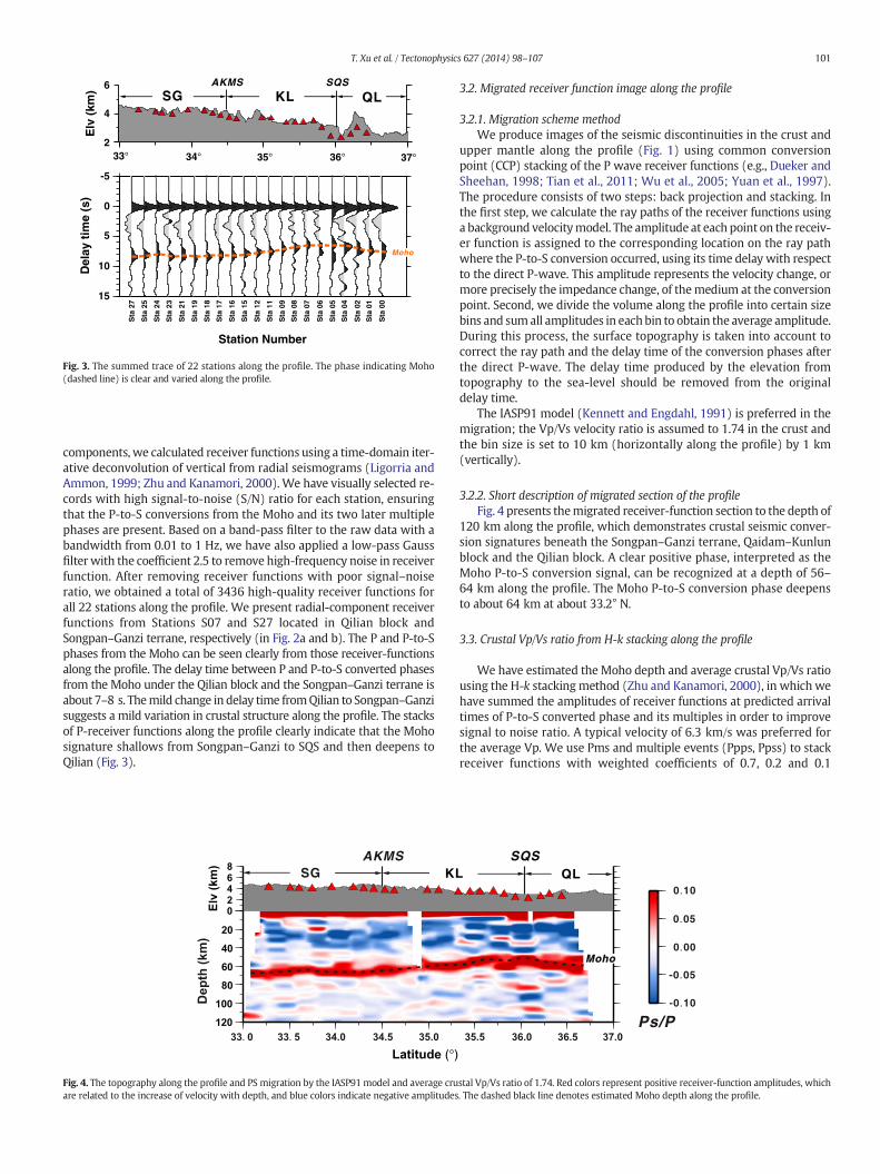
Fig. 3. The summed trace of 22 stations along the profile. The phase indicating Moho(dashed line) is clear and varied along the profile.
101T. Xu et al. / Tectonophysics 627 (2014) 98–107
components, we calculated receiver functions using a time-domain iter-ative deconvolution of vertical from radial seismograms (Ligorria andAmmon, 1999; Zhu and Kanamori, 2000).We have visually selected re-cords with high signal-to-noise (S/N) ratio for each station, ensuringthat the P-to-S conversions from the Moho and its two later multiplephases are present. Based on a band-pass filter to the raw data with abandwidth from 0.01 to 1 Hz, we have also applied a low-pass Gaussfilter with the coefficient 2.5 to remove high-frequency noise in receiverfunction. After removing receiver functions with poor signal–noiseratio, we obtained a total of 3436 high-quality receiver functions forall 22 stations along the profile. We present radial-component receiverfunctions from Stations S07 and S27 located in Qilian block andSongpan–Ganzi terrane, respectively (in Fig. 2a and b). The P and P-to-Sphases from the Moho can be seen clearly from those receiver-functionsalong the profile. The delay time between P and P-to-S converted phasesfrom the Moho under the Qilian block and the Songpan–Ganzi terrane isabout 7–8 s. Themild change in delay time fromQilian to Songpan–Ganzisuggests a mild variation in crustal structure along the profile. The stacksof P-receiver functions along the profile clearly indicate that the Mohosignature shallows from Songpan–Ganzi to SQS and then deepens toQilian (Fig. 3).
SG KLAKMS
Fig. 4. The topography along the profile and PS migration by the IASP91model and average cruare related to the increase of velocity with depth, and blue colors indicate negative amplitudes
3.2. Migrated receiver function image along the profile
3.2.1. Migration scheme methodWe produce images of the seismic discontinuities in the crust and
upper mantle along the profile (Fig. 1) using common conversionpoint (CCP) stacking of the P wave receiver functions (e.g., Dueker andSheehan, 1998; Tian et al., 2011; Wu et al., 2005; Yuan et al., 1997).The procedure consists of two steps: back projection and stacking. Inthe first step, we calculate the ray paths of the receiver functions usinga background velocitymodel. The amplitude at each point on the receiv-er function is assigned to the corresponding location on the ray pathwhere the P-to-S conversion occurred, using its time delay with respectto the direct P-wave. This amplitude represents the velocity change, ormore precisely the impedance change, of themedium at the conversionpoint. Second, we divide the volume along the profile into certain sizebins and sumall amplitudes in eachbin to obtain the average amplitude.During this process, the surface topography is taken into account tocorrect the ray path and the delay time of the conversion phases afterthe direct P-wave. The delay time produced by the elevation fromtopography to the sea-level should be removed from the originaldelay time.
The IASP91 model (Kennett and Engdahl, 1991) is preferred in themigration; the Vp/Vs velocity ratio is assumed to 1.74 in the crust andthe bin size is set to 10 km (horizontally along the profile) by 1 km(vertically).
3.2.2. Short description of migrated section of the profileFig. 4 presents themigrated receiver-function section to the depth of
120 km along the profile, which demonstrates crustal seismic conver-sion signatures beneath the Songpan–Ganzi terrane, Qaidam–Kunlunblock and the Qilian block. A clear positive phase, interpreted as theMoho P-to-S conversion signal, can be recognized at a depth of 56–64 km along the profile. The Moho P-to-S conversion phase deepensto about 64 km at about 33.2° N.
3.3. Crustal Vp/Vs ratio from H-k stacking along the profile
We have estimated the Moho depth and average crustal Vp/Vs ratiousing the H-k stackingmethod (Zhu and Kanamori, 2000), in which wehave summed the amplitudes of receiver functions at predicted arrivaltimes of P-to-S converted phase and its multiples in order to improvesignal to noise ratio. A typical velocity of 6.3 km/s was preferred forthe average Vp. We use Pms and multiple events (Ppps, Ppss) to stackreceiver functions with weighted coefficients of 0.7, 0.2 and 0.1
0.10
0.00
-0.10
0.05
-0.05
QLSQS
Ps/P
Moho
stal Vp/Vs ratio of 1.74. Red colors represent positive receiver-function amplitudes, which. The dashed black line denotes estimated Moho depth along the profile.

STA 03
40 50 60 70
STA 04
40 50 60 70
STA 01
40 50 60 70
STA 02
40 50 60 70
STA 06
40 50 60 701.5
1.6
1.7
1.8
1.9
2.0STA 00
40 50 60 70
Vp
/Vs
1.5
1.6
1.7
1.8
1.9
2.0
Vp
/Vs
1.5
1.6
1.7
1.8
1.9
2.0
Vp
/Vs
STA 11
40 50 60 70
STA 12
40 50 60 70
STA 08
40 50 60 70
STA 09
40 50 60 70
STA 15
40 50 60 70
STA 07
40 50 60 70
STA 17
40 50 60 70
Depth (km) Depth (km) Depth (km) Depth (km) Depth (km) Depth (km)
STA 18
40 50 60 70
STA 19
40 50 60 70
STA 21
40 50 60 70
STA 23
40 50 60 70
STA 27
40 50 60 70
Fig. 5. Average crustal Vp/Vs ratio and Moho depth of 18 stations estimated by the H-k stacking methods. Note that all the figures are in the same color scale.
102 T. Xu et al. / Tectonophysics 627 (2014) 98–107
respectively. The estimated Moho depths of individual stations are alsochosen with reference to the CCP migration stack results. The possibleMoho depth and crustal Vp/Vs ratio below 18 stations are shown inFig. 5. Fig. 6 shows the variation of crustal Vp/Vs ratio and its errors(blue error segment) and Moho depth undulation and its errors (rederror segment) along the profile. Relatively high values of the Vp/Vs
50
60
70
1.5
1.6
1.7
1.8
1.9
2.0
33° 34° 35° 36° 37°
33° 34° 35° 36° 37°
SG KL QLAKMS SQS
Vp
/ V
s
(a)
(b)
Dep
th (
km)
Fig. 6. The value and error of crustal Vp/Vs ratio (blue error segment) and Moho depth(red error segment), plotted for stations along the profile. SG, AKMS, KL, SQS and QL areas in Fig. 1.
ratio are observed under the Songpan–Ganzi terrane (1.76–1.85),which are similar to the results in eastern Songpan–Ganzi terrane inthe profile across LMS belt (1.75–1.85; Zhang et al., 2009), comparedto values in the range 1.65–1.83 under Qaidam–Kunlun block.
4. Discussion
4.1. Comparison with previous studies
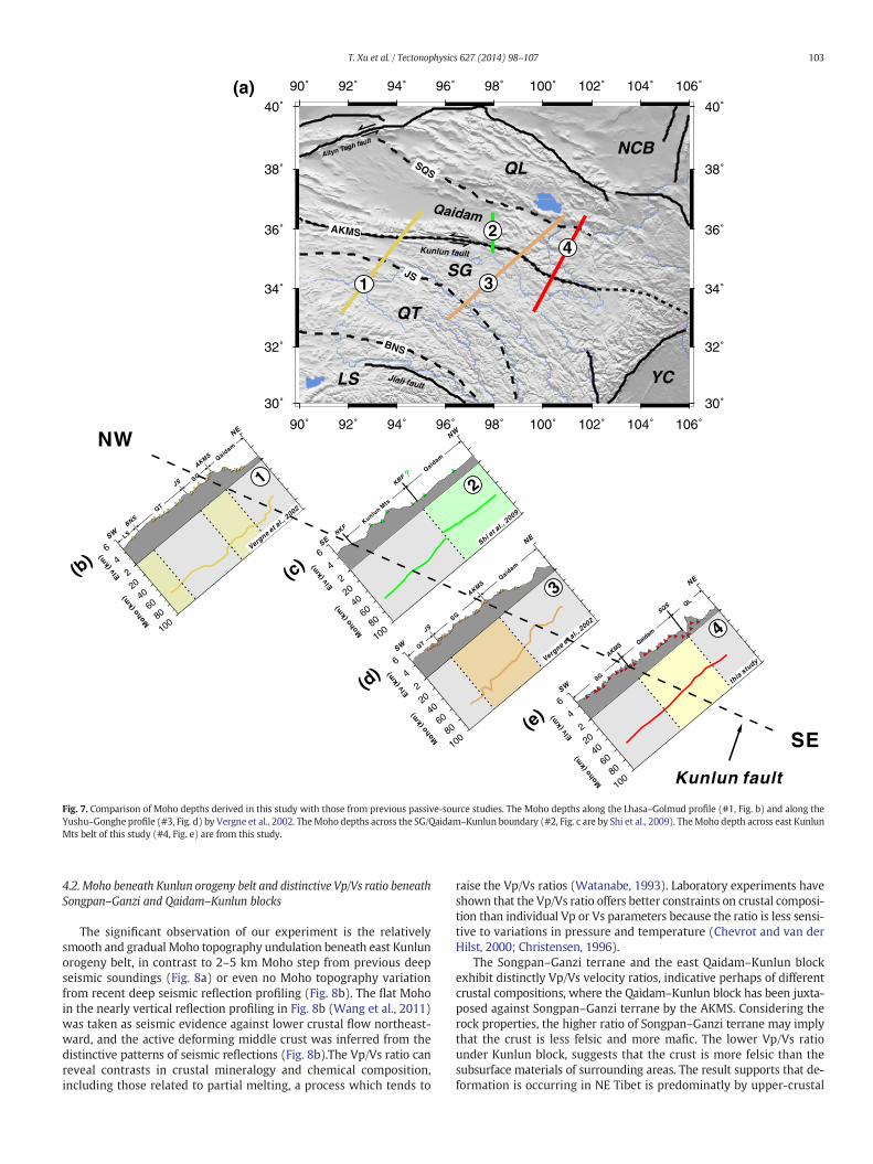
There are numerous active and passive source seismic profiles acrossKunlun fault belt, such as broadband seismic experiments along Lhasa–Golmud (Profile #1 in Fig. 7) and Yushu–Gonghe (Profile #3 in Fig. 7)profiles in Sino–French joint programs (Vergne et al., 2002). From themigrated receiver function section along Lhasa–Golmud profile, Mohodepth is about 65–70 km, Vp/Vs ratio is 1.74–1.84 beneath Songpan–Ganzi, and are about 55–65 km and 1.65–1.77 beneath Qaidam–Kunlunblock, respectively. Along Yushu–Gonghe profile, Moho depth is about70 km, Vp/Vs ratio is 1.72–1.74 beneath Songpan–Ganzi, and areabout 50–65 km, Vp/Vs ratio is 1.72 beneath Qaidam–Kunlun block(Vergne et al., 2002). From our results, Moho depth is about 56–64 km, Vp/Vs ratio is 1.76–1.85 beneath Songpan–Ganzi, and Mohodepth is about 56–62 km, Vp/Vs ratio is 1.65–1.83 beneath Qaidam–
Kunlunblock.Mohodepth derived frompassive source seismic profilingshallows from west to east similar to those derived from deep seismicsounding (Fig. 8a, Zhang et al., 2011).
On the two parallel profiles west of the profile of this study, Mohodepth deepens from about 50 kmnear the northern edge of the plateauto about 80 km at the south of the Jinsha suture in the Qiang Tang block(Profile #1 and Profile #3 in Fig. 7). Crustal thickening occurs in stair-case fashion, oftenwith steps located near themain, reactivated sutures.While on the profile of this study, a relatively smooth and gradualMohotopography undulation is beneath the eastern Kunlun orogeny belt.
90˚
92˚
92˚
94˚
94˚
96˚
96˚
98˚
98˚
100˚
100˚
102˚
102˚
104˚
104˚
106˚
106˚
30˚
32˚ 32˚
34˚ 34˚
36˚ 36˚
38˚ 38˚
40˚ 40˚
QT
SG
QL
BNS
JS
NCB
LS
SQS
AKMS
Kunlun fault
Jiali fault
Altyn Tagh fault
Qaidam
YC
4
1
2
3
(a)
Qaidam
Kunlun M
ts
NKF
KBF ?
Moho
(km
)Elv
(km
)
SE
NW
(c)
2
Shi et a
l., 2009
90˚
30˚
SW
NE
BNS
JS
AKMS Qaidam
SG
QT
LS
Moho
(km
)Elv
(km
)
(b)
1
Vergne et a
l., 2002
NW
SE
Kunlun fault
SG
Moho
(km
)Elv
(km
)
Qaidam
QL
AKMS
SQS
SW
NE
(e)
4
this stu
dy
3
JS
Qaidam
SG
QT
Moho
(km
)Elv
(km
)
AKMS
SW
NE
(d)
Vergne et a
l., 2002
3
Fig. 7. Comparison of Moho depths derived in this study with those from previous passive-source studies. The Moho depths along the Lhasa–Golmud profile (#1, Fig. b) and along theYushu–Gonghe profile (#3, Fig. d) by Vergne et al., 2002. TheMoho depths across the SG/Qaidam–Kunlun boundary (#2, Fig. c are by Shi et al., 2009). TheMoho depth across east KunlunMts belt of this study (#4, Fig. e) are from this study.
103T. Xu et al. / Tectonophysics 627 (2014) 98–107
4.2. Moho beneath Kunlun orogeny belt and distinctive Vp/Vs ratio beneathSongpan–Ganzi and Qaidam–Kunlun blocks
The significant observation of our experiment is the relativelysmooth and gradual Moho topography undulation beneath east Kunlunorogeny belt, in contrast to 2–5 km Moho step from previous deepseismic soundings (Fig. 8a) or even no Moho topography variationfrom recent deep seismic reflection profiling (Fig. 8b). The flat Mohoin the nearly vertical reflection profiling in Fig. 8b (Wang et al., 2011)was taken as seismic evidence against lower crustal flow northeast-ward, and the active deforming middle crust was inferred from thedistinctive patterns of seismic reflections (Fig. 8b).The Vp/Vs ratio canreveal contrasts in crustal mineralogy and chemical composition,including those related to partial melting, a process which tends to
raise the Vp/Vs ratios (Watanabe, 1993). Laboratory experiments haveshown that the Vp/Vs ratio offers better constraints on crustal composi-tion than individual Vp or Vs parameters because the ratio is less sensi-tive to variations in pressure and temperature (Chevrot and van derHilst, 2000; Christensen, 1996).
The Songpan–Ganzi terrane and the east Qaidam–Kunlun blockexhibit distinctly Vp/Vs velocity ratios, indicative perhaps of differentcrustal compositions, where the Qaidam–Kunlun block has been juxta-posed against Songpan–Ganzi terrane by the AKMS. Considering therock properties, the higher ratio of Songpan–Ganzi terrane may implythat the crust is less felsic and more mafic. The lower Vp/Vs ratiounder Kunlun block, suggests that the crust is more felsic than thesubsurface materials of surrounding areas. The result supports that de-formation is occurring in NE Tibet is predominatly by upper-crustal

0 10 20km
0
10
20
30
40
50
60
0
10
20
30
40
50
60
De
pth
fro
m s
urf
ac
e (k
m)
Ap
pro
xim
ate
De
pth
(k
m)
A B CKunlun fault
NW NE(b)
Flat Moho?
0.10
0.00
-0.10
0.05
-0.05
SG KL QLAKMS SQS
Ps/P
Moho
(c)
Moho rising?
AKMS (Kunlun fault)
Qaidam-KunlunSongpan-Ganzi
NESW
Velocity (km/s)
(a)
5.2 5.5 5.8 6.1 6.4 6.7 7.0 7.3 7.6 7.9 8.2
0 50 100 150 200 250 300 350
Distance (km)
Dep
th (
km)
-20
-30
-40
-50
-60
-70
-10
0
Moho deepening?
50 100 150 200 250 300 350
Distance (km)
Fig. 8. (a) Crustal velocitymodel derived from the deep seismic sounding data (Zhang et al., 2011); (b)Moho character from seismic reflection profile (Wang et al., 2011); (c)Moho depthundulation along the profile of this experiment. The cyan lines indicate the seismogenic layer (SL) (withinwhich 80% of the seismic energy is released). The black dashed lines indicate theMoho depth.
104 T. Xu et al. / Tectonophysics 627 (2014) 98–107
thickening, which was inferred from the spatial distribution of crustalthickness and Vp/Vs ratio (Tian and Zhang, 2013).
The composition of the crust has great impact on the Vp/Vs, and alsogives some revelation on the rheology (Watts, 2001), as it reflects theflexural rigidity of the rocks. The rheology has been estimated withyield strength envelope and elastic thickness (Deng et al., 2013; Pérez-Gussinyé et al., 2007; Tesauro et al., 2012). While, in the recent years,the rheological properties of the crust could also be quantified usingthe scheme proposed by Panza and Raykova (2008), i.e., considering
the distribution of the depth of the hypocentres (N) and the seismic en-ergy released E. As a proxy for the rheology, the lack of seismicity doesnot necessarily imply that the lithosphere is locally more rigid (it mayindicate, for example, that there is no active tectonics or that the strainrate is locally lower than in the surroundings) (Panza and Raykova,2008; Wu and Zhang, 2012; Zhang et al., 2011, 2013). All the seismicevents reported during the period 1980 to 2012 in the Catalogue ofthe China Earthquake Network Center (CENC) below this region werecompiled. Consequently, we made 4 contiguous cells along our profile

(a)
90˚ 92˚
92˚
94˚
94˚
96˚
96˚
98˚
98˚
100˚
100˚
102˚
102˚
104˚
104˚
106˚
106˚
30˚ 30˚
32˚ 32˚
34˚ 34˚
36˚ 36˚
38˚ 38˚
40˚ 40˚90˚
AKMS
JS
SQS
Qaidam xining
Kunlun fault
Altyn Ta gh fault
BNS
QT
SG
QLNCB
LS
c1 c2 c3 c4
c5
c6c7 c8
b1
b2
b3
b4
YCJiali fa ul t
(b) NE
199 413 525 61 372 275 637 595Dep
th (
km)
0
20
40
60
80
100
(c1) (c2) (c3) (c4) (c5) (c6) (c7) (c8)
14 34 48 6 57 27 123 144
Dep
th (
km)
0
20
40
60
80
100
(c) SE
64 22083D
epth
(km
)
0
20
40
60
80
100
(b1) (b2) (b3) (b4)
Dep
th (
km)
17 2811
0
20
40
60
80
100
Fig. 9.The earthquakedistribution versus depth (upper panel) and the earthquake energy versus depth by4 km interval (lowpanel) for 4 cells alongour profile (b) and for 8 cells along theKunlun fault (c). The hypocenters with depth are denoted by red dots. The number at the bottom indicates the hypocenters within each cell. The filled red bars histogram represents theenergy of all earthquakes from the catalogue for 1980–2012 provided by China Earthquake Network Center, the maximum value of the energy Emax (used for normalization) is also in-dicated at the bottom of each cell.
105T. Xu et al. / Tectonophysics 627 (2014) 98–107
with the sizes of about 2° in longitude and 1° in latitude dimensions(Fig. 9b) to define the distributions of (a) hypocentral depth (h),(b) log E/Emax versus h. Where, seismic energy (E) is inverted fromearthquake magnitude (Ms): logE = 11.8 + 1.5 Ms (Panza andRaykova, 2008; Zhang et al., 2011; Zhang et al., 2013). The depth atwhich 80% of earthquake energy is released is termed as seismogeniclayer SL (Deng et al., 2012; Panza et al., 2003; Wu and Zhang, 2012;Zhang et al., 2011, 2012, 2013), which reflects the extent of faultingand strength in the uppermost part of the lithosphere. From the 4cells, we can observe that the earthquakes are concentrated in theupper crust (b30 km) (Gao et al., 2000). And the thickness of SL in b3and b4 is 10 km thicker than b1 and b2 (about 20 km beneathSongpan–Ganzi and about 30 km beneath Kunlun and Qilian block).As the cell b2 passed through the AKMS, the seismicity here is remark-able stronger than the other three cells. Compared with b1, b3, and b4,we find that regionwith stronger seismicity corresponds to a low Vp/Vs(Fig. 6), as the cell b4, which is consistent with the thicker seismogeniclayer in Qilian block.
4.3. West–east variation of crustal structure and its possible relations withsurface deformation
Qaidam–Kunlun block is juxtaposed against the Songpan–Ganziterrane by the AKMS suture and the Kunlun fault. The Kunlun faultonly became active as a strike–slip system during the last 7 Ma, with atotal slip of 75 km (Fu and Awata, 2007) and a late Quaternary sliprate of 12 ± 3 mm/yr (van der Woerd et al., 2000). Slip rates decreasesystematically along the eastern ~150 km of the fault from N10 tob2 mm/yr (purple rectangles marked with a, b and c in Fig. 1, Kirbyet al., 2007; Van der Woerd et al., 2000, 2002).
Wemade statistics of seismic events in 8 cells with the sizes of about2° in Longitude and 1° in latitude dimensions along the Kunlun fault inthe sameway as above (Fig. 9c). The pattern difference of seismic ener-gy release between cells c1 and c8 exhibits significant variation of seis-mic energy release along the Kunlun fault. From Fig. 9c, we can observethat seismogenic layer varies slightly from less than 20 km in the west(about 90°E) to about 30 km in the east (106°E) along the Kunlun

106 T. Xu et al. / Tectonophysics 627 (2014) 98–107
fault. The Moho depth varies from 60 to 70 km from in the west to lessthan 50 km in the east (Teng et al., 2013; Zhang et al., 2011). The non-seismogenic layer, the area which is restricted by the lower border ofseismogenic zone and Moho, keeps mild change of 40 km from 90° to100°E, while changes to less than 20 km east of 100°E. The tendencyof non-seismogenic layer is consistent with the lower crustal thicknessderived from deep seismic sounding (Zhang et al., 2011). The increasedcrustal thickness may be due to the differences in the thickness of thecrust of the two plates before their collision, and/or largely achievedby thickening of the lower crust, perhaps indicating a crustalflowmech-anism operating more strongly in the western region.
5. Conclusion
Based on the receiver function imaging and H-k stackingresults along the profile in the northern Tibet. Our interpretationof the passive source seismic profiling suggests the followingconclusions:
(1) Crustal thickness exhibits a mild variation from ~56 to 62 kmunder the Qilian block and Qaidam–Kunlun block, to ~64 kmunder the Songpan–Ganzi terrane.
(2) The distinctive velocity ratio differences across AKMS mark thatKunlun block is juxtaposed against Songpan–Ganzi terrane bythe AKMS. The lower Vp/Vs ratio under Qaidam–Kunlun blocksupports why the deformation occurring in NE Tibet is predomi-nated by upper-crustal thickening (Tian and Zhang, 2013).
(3) The non-seismogenic layer varies slightly from 40 km in 90° to100°E, then decreases to less than 20 km in 106°E along theKunlun fault. The tendency of non-seismogenic layer, consistentwith the lower crust thickness derived from deep seismic sound-ing. The increased crustal thicknessmay be due to the differencesin the thickness of the crust of the two plates before their colli-sion, and/or largely achieved by thickening of the lower crust,perhaps indicating a crust flow mechanism operating morestrongly in the western region.
Acknowledgments
We gratefully acknowledge the financial support of the Ministry ofLand and Resources of China (SinoProbe-02-02, SinoProbe-02-03), theMinistry of Science and Technology of China (2011CB808904), ChineseAcademyof Sciences (XDB03010700), theNational Natural Science Foun-dation of China (41021063, 41174075, 41004034, and 41174043). Weappreciate the Seismological Experiment Lab., IGGCAS, Drs. ChangqingSun and Fei Li for acquisition of field data. We are grateful to threeanonymous reviewers for detailed critical comments and constructivesuggestions for improvements of the manuscript. We are especiallythankful to Prof. Yong Zheng from Insititute of Geodesy and Geophysics,CAS, Drs Xiaofeng Liang and Yun Chen for helpful discussions and sugges-tions to improve the quality of this work.
References
Ammon, C.J., 1991. The isolation of receiver effects from teleseismic P waveforms. Bull.Seismol. Soc. Am. 81, 2504–2510.
Arnaud, N.O., Vidal, P., Tapponnier, P., Matte, P., Deng, W.M., 1992. The high K2O volcanismof northwestern Tibet: geochemistry and tectonic implications. Earth Planet. Sci. Lett.111, 351–367.
Avouac, J., Tapponnier, P., 1993. Kinematic model of active deformation in central Asia.Geophys. Res. Lett. 20. http://dx.doi.org/10.1029/93GL00128.
Bian, Q.T., Li, D.H., Pospelov, I., Yin, L.M., Li, H.S., Zhao, D.S., Chang, C.F., Luo, X.Q., Gao, S.L.,Astrakhantsev, O., Chamov, N., 2004. Age, geochemistry and tectonic setting ofBuqingshan ophiolites, North Qinghai–Tibet Plateau, China. J. Asian Earth Sci. 23(4), 577–596.
Chevrot, S., van der Hilst, R.D., 2000. The Poisson ratio of the Australian crust: geologicaland geophysical implications. Earth Planet. Sci. Lett. 183, 121–132.
Christensen, N.I., 1996. Poisson’s ratio and crustal seismology. J. Geophys. Res. 101,3139–3156.
Deng, W.M., 1997. Cenozoic volcanism and lithosphere tectonic evolution in the northernTibetan plateau, China. In: Li, Z.N., Qi, J.Z., Zhang, Z.C. (Eds.), Igneous Petrology. 30thInternational Geological Congress, vol. 15, pp. 3–12 (Utrecht, The NetherlandsTokyo, Japan).
Deng, Y., Fan, W., Zhang, Z., Badal, J., 2012. Geophysical evidence on segmentation of theTancheng-Lujiang fault and its implications on the lithosphere evolution in EastChina. J. Asian Earth Sci. http://dx.doi.org/10.1016/j.jseaes.2012.11.006.
Deng, Y., Zhang, Z., Fan, W., Pérez-Gussinyé, M., 2013. Multitaper spectral method toestimate the elastic thickness of South China: implications for intracontinentaldeformation. Geosci. Front. http://dx.doi.org/10.1016/j.gsf.2013.05.002.
Dueker, K.G., Sheehan, A.F., 1998. Mantle discontinuity structure beneath the ColoradoRocky Mountains and High Plains. J. Geophys. Res. 103, 7153–7169.
Elena, A.K., Brunel, M., Malavielle, J., 2003. Discovery of the Paleo-Tethys residual perido-tites along the Anyemaqen–KunLun suture zone (North Tibet). Compt. RendusGeosci. 335 (8), 709.
Fu, B.H., Awata, Y., 2007. Displacement and timing of left-lateral faulting in the KunlunFault Zone, northern Tibet, inferred geologic and geomorphic features. J. AsianEarth Sci. 29, 253–265.
Fu, B., Awata, Y., Du, J., Ninomiya, Y., He, W., 2005. Complex geometry and segmentationof the surface rupture associated with the 14 November 2001 great Kunlun earth-quake, northern Tibet, China. Tectonophysics 407, 43–63. http://dx.doi.org/10.1016/j.tecto.2005.07.002.
Galvé, A., Hirn, A., Jiang, M., Gallart, J., de Voogd, B., Lepine, J.C., Diaz, J., Wang, Y.X., Qian,H., 2002. Modes of raising northeastern Tibet probed by explosion seismology. EarthPlanet. Sci. Lett. 203, 35–43.
Gao, Y., Wu, Z.-L., Liu, Z., Zhou, H.-L., 2000. Seismic source characteristics of ninestrong earthquakes from 1988 to 1990 and earthquake activity since 1970 inthe Sichuan–Qinghai–Xizang (Tibet) zone of China. Pure Appl. Geophys. 157(9), 1423–1443.
Jiang, C.F., Wang, Z.Q., Li, J.Y., 2000. Opening-Closing tectonics of the Central Orogenic Beltin China. Geological Publishing House, Beijing (154 pp., in Chinese, with Englishabstract).
Jiang, M., Galvé, A., Hirn, A., de Voogd, B., Laigle, M., Su, H.P., Diaz, J., Lépine, J.C., Wang,Y.X., 2006. Crustal thickening and variations in architecture form the Qaidam basinto the Qang Tang (North-Central Tibetan Plateau) from wide-angle reflection seis-mology. Tectonophysics 412, 121–140.
Kennett, B.L.N., Engdahl, E.R., 1991. Traveltimes for global earthquake location and phaseidentification. Geophys. J. Int. 105 (2), 429–465.
Kind, R., Yuan, X., Saul, J., Nelson, D., Sobolev, S.V., Mechie, J., Zhao, W., Kosarev, G., Ni, J.,Achauer, U., Jiang, M., 2002. Seismic images of crust and upper mantle beneath Tibet:evidence for Eurasian Plate subduction. Science 298, 1219–1221.
Kirby, E., Harkins, N., Wang, E., Shi, X., Fan, C., Burbank, D., 2007. Slip rate gradients alongthe eastern Kunlun fault. Tectonics 26, TC2010. http://dx.doi.org/10.1029/2006TC002033.
Ligorria, J.P., Ammon, C.J., 1999. Iterative deconvolution and receiver function estimation.Bull. Seismol. Soc. Am. 89, 1395–1400.
Liu, M.J., Mooney, W.D., Li, S.L., Okaya, N., Detweiler, S., 2006. Crustal structure of thenortheastern margin of the Tibetan plateau from the Songpan-Ganzi terrane to theOrdos basin. Tectonophysics 420, 253–266.
Molnar, P., England, P., Martinod, J., 1993. Mantle dynamics, uplift of the Tibetan plateauand the Indian Monsoon. Rev. Geophys. 31, 357–396.
Panza, G.F., Pontevivo, A., Chimera, G., Raykova, R., Aoudia, A., 2003. The lithosphere-as-thenosphere: Italy and surroundings. Episodes-Newsmagazine of the InternationalUnion of Geological Sciences 26 (3), 169–174.
Panza, G.F., Raykova, R.B., 2008. Structure and rheology of lithosphere in Italy andsurrounding. Terra Nova 20 (3), 194–199.
Pearce, J.A., Mei, H.J., 1988. Volcanic rocks of the 1985 Tibet geotraverse Lhasato Golmud. The geological evolution of Tibet. Philos. Trans. R. Soc. Lond.169–201.
Pérez-Gussinyé, M., Lowry, A., Watts, A., 2007. Effective elastic thickness of South Americaand its implications for intracontinental deformation. Geochem. Geophys. Geosyst. 8(5), 22.
Shi, D., Shen, Y., Zhao, W., Li, A., 2009. Seismic evidence for a Moho offset and south-directed thrust at the easternmost Qaidam–Kunlun boundary in the NortheastTibetan plateau. Earth Planet. Sci. Lett. 288, 329–334.
Tapponnier, P., Xu, Z., Roger, F., Meyer, B., Arnaud, N., Wittlinger, G., Yang, J., 2001. Obliquestepwise rise and growth of the Tibet plateau. Science 294, 1671–1677.
Teng, J.W., Zhang, Z.J., Zhang, X.K., Wang, C.Y., Gao, R., Yang, B.J., Qiao, Y.H., Deng, Y.F.,2013. Investigation of the Moho discontinuity beneath the Chinese mainlandusing deep seismic sounding profiles. Tectonophysics 609, 202–216.
Tesauro, M., Kaban, M.K., Cloetingh, S.A., 2012. Global strength and elastic thickness of thelithosphere. Glob. Planet. Chang. 90, 51–57.
Tian, X., Zhang, Z., 2013. Bulk crustal properties in NE Tibet and their implications fordeformation model. Gondwana Res. 24, 548–559. http://dx.doi.org/10.1016/j.gr.2012.12.024.
Tian, X.B., Teng, J.W., Zhang, H.S., Zhang, Z.J., Zhang, Y.Q., Yang, H., 2011. Structure of crustand upper mantle beneath the Ordos Block and the Yinshan Mountains revealed byreceiver function analysis. Phys. Earth Planet. Inter. 184, 186–193. http://dx.doi.org/10.1016/j.pepi.2010.11.007.
Van der Woerd, J., Ryerson, F.J., Tapponnier, P., Meriaux, A.S., Gaudemer, Y., Meyer, B.,Finkel, R.C., Caffee, M.W., Zhao, G.G., Xu, Z.Q., 2000. Uniform slip-rate along theKunlun Fault: implications for seismic behaviour and large-scale tectonics. Geophys.Res. Lett. 27, 2353–2356.
Van der Woerd, J., Tapponnier, P., Ryerson, F.J., Meriaux, A.S., Meyer, B., Gaudemer, Y.,Finkel, R.C., Caffee, M.W., Zhao, G., Xu, Z., 2002. Uniform postglacial slip-rate alongthe central 600 km of the Kunlun Fault (Tibet), from 26Al, 10Be, and 14C dating of

107T. Xu et al. / Tectonophysics 627 (2014) 98–107
riser offsets, and climatic origin of the regional morphology. Geophys. J. Int. 148,356–388.
Vergne, J., Wittlinger, G., Qiang, H., Tapponnier, P., Poupinet, G., Jiang, M., Herquel, G., Paul,A., 2002. Seismic evidence for stepwise thickening of the crust across the NE Tibetanplateau. Earth Planet. Sci. Lett. 203, 25–33.
Wang, Y.B., Huang, J.C., Luo, M.S., Tian, J., Bai, Y.S., 1997. Paleo-ocean evolution of thesouthern eastern Kunlun orogenic belt during Hercy-Early Indosinian. Earth Sci.China Univ. Geosci. 22, 369–372 (in Chinese, with English abstract).
Wang, C.S., Gao, R., Yin, A., Wang, H.Y., Zhang, Y.X., Guo, T.L., Li, Q.S., Li, Y.L., 2011. A mid-crustal strain-transfer model for continental deformation: a new perspective fromhigh-resolution deep seismic-reflection profiling across NE Tibet. Earth Planet. Sci.Lett. 306, 279–288.
Wang, Y.X., Mooney, W., Yuan, X.C., Okaya, N., 2013. Crustal structure of the NortheasternTibetan Plateau from the Southern Tarim basin to the Sichuan Basin, China.Tectonophysics 584, 191–208.
Watanabe, T., 1993. Effects of water andmelt on seismic velocities and their application tocharacterization of seismic reflectors. Geophys. Res. Lett. 20, 2933–2936.
Watts, A.B., 2001. Isostasy and Flexure of the Lithosphere. Cambridge University Press.Wu, J., Zhang, Z.J., 2012. Spatial distribution of seismic layer, crustal thickness, and
Vp/Vs ratio in the Permian Emeishan Mantle Plume region. Gondwana Res. 22,127–139.
Wu, Q.J., Zeng, R.S., Zhao, W.J., 2005. The upper mantle structure of the Tibetan Plateauand its implication for the continent–continent collision. Sci. China Ser. D 48,1158–1164.
Xu, Z.Q., Hou, L.W., Wang, Z.X., Fu, X.F., Huang, M.H., 1992. Orogenic Processes of theSongpan–Ganze Orogenic Belt of China. Geological Publishing House, Beijing (inChinese).
Yang, J.S., Robinson, P.T., Jiang, C.F., Xu, Z.Q., 1996. Ophiolites of the Kunlun Mountains,China and their tectonic implications. Tectonophysics 258, 215–231.
Yin, A., Harrison, T.M., 2000. Geologic evolution of the Himalayan–Tibetan orogen. Annu.Rev. Earth Planet. Sci. 28, 211–280.
Yuan, X.C., Hua, J.R., 1996. Geophysics Atlas of China. Geology Press, Beijing 135–144.
Yuan, X., Ni, J., Kind, R., Mechie, J., Sandvol, E., 1997. Lithospheric and uppermantle structureof southern Tibet from a seismological passive source experiment. J. Geophys. Res. 102,27,491–27,500. http://dx.doi.org/10.1029/97JB02379.
Zhang, Z.J., Wang, Y., Chen, Y., Houseman, G.A., Tian, X., Wang, E., Teng, J., 2009. Crustalstructure across Longmenshan fault belt from passive source seismic profiling.Geophys. Res. Lett. 36, L17310. http://dx.doi.org/10.1029/2009GL039580.
Zhang, Z.J., Yuan, X.H., Chen, Y., Tian, X.B., Kind, R., Li, X.Q., Teng, J.W., 2010a. Seismicsignature of the collision between the east Tibetan escape flow and the SichuanBasin. Earth Planet. Sci. Lett. 292, 254–264.
Zhang, Z.J., Deng, Y.F., Teng, J.W., Wang, C.Y., Gao, R., Chen, Y., Fan, W.M., 2010b. Anoverview of the crustal structure of the Tibetan plateau after 35 years of deep seismicsoundings. J. Asian Earth Sci. http://dx.doi.org/10.1016/j.jseaes.2010.03.010.
Zhang, C., Yang, D., Wang, H., Takahashi, Y., Ye, H., 2010c. Neoproterozoic maficultramaficlayered intrusion in Quruqtagh of northeastern Tarim Block, NW China: two phasesof mafic igneous activity with different mantle resources. Gondwana Res. http://dx.doi.org/10.1016/j.gr.2010.03.012.
Zhang, Z.J., Klemperer, S., Bai, Z.M., Chen, Y., Teng, J.W., 2011. Crustal structure of thePaleozoic Kunlun orogeny from an active-source seismic profile between Moba andGuide in East Tibet, China. Gondwana Res. 19, 994–1007.
Zhang, Z., Wu, J., Deng, Y., Teng, J., Zhang, X., Chen, Y., Panza, G., 2012. Lateral variation ofthe strength of lithosphere across the eastern North China Craton: New constraintson lithospheric disruption. Gondwana Research 22 (3), 1047–1059.
Zhang, Z.J., Deng, Y.F., Chen, L., Wu, J., Teng, J.W., Panza, G., 2013. Seismic structure andrheology of the crust under mainland China. Gondwana Res. 23, 1455–1483.
Zhao, W.J., Brown, L., Wu, Z., Klemperer, S.L., Shi, D., Mechie, J., Su, H., Tilmann, F., Karplus,M.S., Makovsky, Y., 2008. Seismology Across the Northeastern Edge of the TibetanPlateau. EOS Trans. Am. Geophys. Union 89 (48), 487.
Zhu, L.P., Helmberger, L.V., 1998. Moho offset across the northern margin of Tibetanplateau. Science 281, 1170–1172.
Zhu, L.P., Kanamori, H., 2000. Moho depth variation in southern California fromteleseismic receiver functions. J. Geophys. Res. 105, 2969–2980. http://dx.doi.org/10.1029/1999JB900322.