Crustal evolution of the SaykFigures reduced file size · · 2012-03-26... Implications for...
57
1 Crustal evolution of the Saykhandulaan Inlier, Mongolia: Implications for Palaeozoic arc magmatism, polyphase deformation and terrane accretion in the Southeast Gobi Mineral Belt James H.S. Blight a , Dickson Cunningham a , Michael G. Petterson b a Department of Geology, University of Leicester, UK b British Geological Survey, Keyworth, UK Abstract The Saykhandulaan Inlier in South East Mongolia lies within the Central Asian Orogenic Belt (CAOB), and records Palaeozoic continental accretion on the northern margin of the Palaeo-Asian ocean. The inlier spans the boundary between two important terranes of the CAOB. The Gobi Altai back-arc basin terrane in the north formed between the continental core of Mongolia, and the arc terranes of the CAOB. The Mandalovoo island arc terrane hosts many mineralised intrusions and was laterally equivalent to the arc that hosts the Oyu Tolgoi gold-rich copper porphyry deposit to the south. Fieldwork traverses across the structural grain of the Saykhandulaan inlier have established five parallel E-W-elongate litho-tectonic domains; the Northern Slate Belt, comprised of Devonian greenshist grade pelites and psammites, with deep-marine to coastal silici-clastic protoliths; the Saykhandulaan Valley Lineament Zone, comprising a zone of faulting featuring slivers of altered volcanic stratigraphy; the High Strain Belt, composed of tightly folded and flattened meta-clastic rocks; the Molasse Sucession (MS), relatively undeformed coarse conglomerates and sandstones and the Oyut Ulaan Volcanic Group, a folded volcanic-sucession, up to 5km thick. The Oyut Ulaan Volcanic rocks host a mid-Carboniferous mineralised granite; the Oyut Ulaan intrusion. The Northern Slate Belt records a cratonic provenance, whereas all parts of the inlier to the south have arc affinities. The Saykhandulaan Valley Lineament Zone divides the area into northern and southern provenance domains, and delineates the boundary between the Gobi Altai and Mandalovoo terranes. Two major deformation events are identified following basin closure; related to basin inversion (D 1 ) and accretion of the Mandalovoo arc-terrane (D 2 ). Basin inversion resulted in regional scale folding and greenschist grade metamorphism in the Northern Slate and High Strain Belts. During terrane accretion the Oyut Ulaan Volcanic Group was folded and thrusting took place along the Saykahndulaan Valley Zone, exhuming the highly deformed rocks of the High Strain Belt. Subsequent to the cessation of subduction, crustal extension and strike-slip faulting have further modified the crustal architecture of the inlier. The results presented here provide a useful framework for understanding the crustal evolution of adjacent regions within the southeast Gobi mineral belt.
Transcript of Crustal evolution of the SaykFigures reduced file size · · 2012-03-26... Implications for...

1
Crustal evolution of the Saykhandulaan Inlier, Mongolia: Implications for Palaeozoic arc magmatism,
polyphase deformation and terrane accretion in the Southeast Gobi Mineral Belt
James H.S. Blight a, Dickson Cunningham a, Michael G. Petterson b
a Department of Geology, University of Leicester, UK
b British Geological Survey, Keyworth, UK
Abstract
The Saykhandulaan Inlier in South East Mongolia lies within the Central Asian Orogenic Belt
(CAOB), and records Palaeozoic continental accretion on the northern margin of the Palaeo-Asian
ocean. The inlier spans the boundary between two important terranes of the CAOB. The Gobi Altai
back-arc basin terrane in the north formed between the continental core of Mongolia, and the arc
terranes of the CAOB. The Mandalovoo island arc terrane hosts many mineralised intrusions and was
laterally equivalent to the arc that hosts the Oyu Tolgoi gold-rich copper porphyry deposit to the south.
Fieldwork traverses across the structural grain of the Saykhandulaan inlier have established five
parallel E-W-elongate litho-tectonic domains; the Northern Slate Belt, comprised of Devonian
greenshist grade pelites and psammites, with deep-marine to coastal silici-clastic protoliths; the
Saykhandulaan Valley Lineament Zone, comprising a zone of faulting featuring slivers of altered
volcanic stratigraphy; the High Strain Belt, composed of tightly folded and flattened meta-clastic rocks;
the Molasse Sucession (MS), relatively undeformed coarse conglomerates and sandstones and the Oyut
Ulaan Volcanic Group, a folded volcanic-sucession, up to 5km thick. The Oyut Ulaan Volcanic rocks
host a mid-Carboniferous mineralised granite; the Oyut Ulaan intrusion.
The Northern Slate Belt records a cratonic provenance, whereas all parts of the inlier to the
south have arc affinities. The Saykhandulaan Valley Lineament Zone divides the area into northern
and southern provenance domains, and delineates the boundary between the Gobi Altai and
Mandalovoo terranes.
Two major deformation events are identified following basin closure; related to basin inversion
(D1) and accretion of the Mandalovoo arc-terrane (D2). Basin inversion resulted in regional scale
folding and greenschist grade metamorphism in the Northern Slate and High Strain Belts. During
terrane accretion the Oyut Ulaan Volcanic Group was folded and thrusting took place along the
Saykahndulaan Valley Zone, exhuming the highly deformed rocks of the High Strain Belt. Subsequent
to the cessation of subduction, crustal extension and strike-slip faulting have further modified the
crustal architecture of the inlier. The results presented here provide a useful framework for
understanding the crustal evolution of adjacent regions within the southeast Gobi mineral belt.

2
1 Introduction
The Gobi region of southeastern Mongolia lies within the Central Asian
Orogenic Belt (CAOB), Earth’s largest area of Phanerozoic continental growth, and is
a natural laboratory for documenting processes of terrane accretion and
amalgamation. Important mineral deposits have been discovered in the SE Gobi
region during the last decade and consequently the region is now a major mineral
exploration province. Nevertheless, few studies exist documenting the basement
evolution and lithotectonic context of the SE Gobi mineral belt. This is partly
because the area is remote, has low relief, and in general, displays poor outcrop
exposure. However, the Saykhandulaan Inlier (Fig. 1), which crops-out 400km to the
south of Ulaan Baatar is unusual because it contains a large area of basement
exposure and provides a good opportunity for unravelling the major tectonic,
metamorphic and intrusive events that have affected the SE Gobi mineral belt. In
addition, it hosts the Oyut Ulaan Cu-Au porphyry prospect and is along strike of other
major exploration targets in the region. Therefore, a detailed multidisciplinary study
incorporating field investigations and structural and geochemical analysis was carried
out during 2004-2006 to document the crustal evolution of the Saykhandulaan Inlier
and the terrane context of SE Gobi mineralisation.
1.1 Regional geology
The CAOB records terrane accretion and crustal growth between the Angaran
craton (also known as the Siberian Craton) and the North China Craton from the Late
Precambrian to Permian (Fig. 1). The CAOB reaches from Kazakhstan to Eastern

3
Siberia and averages around 300km wide (Xiao et al., 2003; 2004). Terranes in
Southern Mongolia lie within the CAOB, to the north of the main Permian Solonker
suture, which marks the final closure of the Palaeo-Asian Ocean in the Permian (Xiao,
2003). The basement geology of South Mongolia consists of island-arc,
backarc/forearc basin and accretionary prism terranes that accreted around a
Precambrian cratonic block that lies under the Hangay Dome in central Mongolia
(Fig. 1; Sengor and Natal’in, 1996; Badarch et al. 2002). These terranes record the
tectonic evolution of the northern margin of the Palaeo-Asian Ocean during the
Palaeozoic, generally interpreted to have taken place above a northward dipping
subduction zone.
Two hypotheses exist for the formation of the Mongolian CAOB crust during
the Palaeozoic. �engör and Natal'in (1996), postulated one long-lived island-arc, with
a complex history of magmatic front migration, strike-slip motion and oroclinal
bending along its length prior to terminal accretion (Fig. 2a). An alternative model by
Badarch et al (2002), proposed the existence of multiple island arcs drifting across the
Palaeo-Asian Ocean and accreting various arc-marginal basin terranes and ophiolite
slivers before terminal collision against the southern margin of Siberia/Hangay (Fig.
2b).
Badarch et al. (2002) suggest that southeastern Mongolia is dominated by two
Ordovician-Carboniferous island-arc terranes (Fig. 1), the Gurvansaykhan and
Mandalovoo terranes, which are surrounded by back-arc/fore-arc basins; the
Ordovician-Carboniferous Gobi Altai terrane to the north and the Nuhetdavaa terrane
to the south. The Gurvansaykhan and Mandalovoo terranes are interpreted to have
originally been along-strike equivalents of the same island arc, but dextral strike-slip
faults shunted the Gurvansaykhan terrane southwest to its current location. South of

4
these two terranes, near the Sino-Mongolian border, a series of parallel island-arc,
accretionary wedge and cratonal terranes record a separate subduction-accretion
history (Figs. 1, 2; Badarch et al 2002).
Subsequent to Palaeo-Asian suturing at the end of the Permian, Mongolia
underwent several periods of intracontinental deformation. Left-lateral strike-slip
faults were active in southeast Mongolia from the Triassic to late Cretaceous (Lamb et
al., 1999) and between 185-235km of left-lateral offset occurred along the Zuunbayan
Fault, which forms the southeast margin of the Gurvansaykhan terrane (Fig. 1).
Further west, a Jurassic contractional phase of deformation is expressed by E-W
trending thrust faults along the Mongolian-Chinese border (Zheng et al., 1996).
Southeast Mongolia and adjacent regions of China experienced a major phase of NW-
SE crustal extension during the Jurassic-Cretaceous (Meng et al., 2003). Jurassic-
Cretaceous clastic and volcanic stratigraphy fill low-relief basins throughout the
region including areas adjacent to the Saykhandulaan Inlier. The rifting is interpreted
to be a distal effect of Pacific-rim back-arc extension (Graham et al., 2001).
Cretaceous-Tertiary thermal uplift and volcanism are widely distributed in central,
southern and southeastern Mongolia and are possibly related to a steady state thermal
anomaly in the mantle beneath Mongolia and Eastern China (Barry and Kent, 1998).
Sinistral transpressional deformation driven by the Indo-Eurasia collision, has
reactivated the Gobi Altai region in south and west Mongolia during the late Cenozoic
(Cunningham, 1998). However, there is only limited evidence for renewed tectonism
in southeast Mongolia (Webb and Johnson, 2006)
Major porphyry copper discoveries in the region include the Oyu Tolgoi gold-
rich deposit, which occurs within the Gurvansaykhan arc terrane, 260km to the
southwest of the Saykhandulaan Inlier (Fig. 1; Badarch et al., 2002). Mineralisation

5
at Oyu Tolgoi is associated with arc related Siluro-Devonian porphyry magmatism
intruded into lavas and clastic sedimentary rocks (Perello et al., 2001). Another
important deposit is Tsagaan Suvarga, a copper-molybdenum porphyry hosted in a
Devonian calc-alkaline granite complex, 120km southwest of the Saykhandulaan
Inlier (Fig. 1; (Watanabe and Stein, 2000). To the north, the Mandalovoo terrane also
contains several porphyry-style prospects in an east-west trending belt. Part of the
Mandalovoo terrane lies within the Saykhandulaan Inlier and contains the Oyut Ulaan
copper-gold prospect (Fig. 1).
2 Geology
The Saykhandulaan Inlier spans the boundary between the Gobi Altai terrane to
the north, and the Mandalovoo terrane to the south (Fig. 1). The Saykhandulaan
Valley Lineament Zone (SVLZ) trends approximately east-west and marks the terrane
boundary through the inlier (Fig. 3). Five lithological and structural domains are
identified within the inlier (Fig. 3). North of the SVLZ is the Northern Slate Belt
(NSB) which contains folded siliciclastic meta-sediments. The NSB is overlapped in
the east and north by several basalt fields (undated, but probably correlative with
Jurassic-Cretaceous lavas elsewhere in the region). The SVLZ is 1 - 1.5 km wide and
contains a range of locally exposed lithologies, including volcanic lithologies of the
Saykhandulaan Valley Formation (SVF) which mainly consist of altered intermediate
and felsic lavas. To the south of the SVLZ are several parallel litho-tectonic domains:
The High Strain Belt (HSB) contains greenschist grade meta-sandstones and
conglomerates deformed into tight-to-isoclinal folds. It is exposed across the full
east-west width of the inlier. The Molasse Succession (MS) contains relatively
undeformed conglomerates, sandstones and mudstones, and crops out to the south of
the HSB. The Oyut Ulaan Volcanic Group (OUVG) contains a wide range of

6
volcanic and sedimentary lithologies and defines the southern margin of the inlier.
The Oyut Ulaan Intrusion (OUI) cuts rocks of the OUVG in the south east (Fig. 3)
corner of the inlier. The inlier is surrounded by basins containing Upper Jurassic to
Cretaceous and Quaternary sediments (Figs. 3, 4 and 5; Graham et al., 2001). The
inlier contains subdued topography with a maximum relief of 50m, outcrop quality is
variable and in many areas contacts and faults are not exposed.
In this section, the lithologies of each of the domains defined above are
described in detail from north to south.
2.1 Slate belt
The Northern Slate Belt is a folded, greenschist grade, meta-sedimentary
sequence (Figs. 3 and 4). In the north, this sequence is dominated by pelites with
well-developed cleavage; the protolith coarsens to the south where fine- to medium-
grained psammites locally dominate. An outstanding feature of this unit is the
presence of abundant and volumetrically significant quartz veins.
The main rock type of the NSB is grey pelite, which crops-out in beds 0.5 to 2
metres thick throughout the belt. Graded bedding occurs and locally units exhibit clay
drapes and fine-sand lag-bases. The sequence also features sparsely distributed 20 to
50cm-thick beds of fine- to medium-grained meta-psammite which appear brown on
weathered surfaces.
In the west of the NSB where shallower stratigraphic levels are exposed,
psammitic lithologies are dominant, featuring up to 1-metre-thick medium-grained
units interbedded with relatively thin 20-30 cm pelitic material. In one section, flame
and lobe structures, rip-up clasts and swaley cross stratification occur in the psammite
beds and provide younging criteria, however, original sedimentary features were
rarely observed outside of psammite dominated areas.

7
Lithologies from the southwest corner of the NSB are generally less-deformed,
are of a lower metamorphic grade than the rest of the belt, and are sandstone
dominated. Lithological logs from the south of the NSB show tabular sandstone
bodies of between 10 and 50cm thickness, interbedded with mudstone sequences of
up-to 1m thick. Flame structures, lag bases, rip-up clasts and climbing ripples are
present (Fig. 6).
In thin-section, the sand-grade units show different degrees of deformation and
metamorphism, from relatively un-cleaved greywacke, to greenshist-grade
psammites. The metamorphic fabric consists of re-crystallised quartz grains and a
micaceous slatey cleavage. Several samples display a penetrative crenulation
cleavage and some have isolated kink bands. Siderite forms a cement and secondary
replacement phase. The rocks are generally more calcareous in the northern sector of
the NSB; sparse outcrops of a bio-micritic limestone occur near its northern boundary
with Cretaceous basin-sediments.
Throughout the NSB, quartz veins cut the succession, the largest of which can
be seen from tens of kilometres away and form the highest topographic features in the
belt (Fig. 7). The veins trend ENE deviating from the orientation of the regional
cleavage by 10 - 20°. Three generations of veins occur, the oldest are metre-wide
veins (Fig. 7b) which are commonly cut by main mega-vein bodies (Fig. 7 a), which
are, in turn, cut by later thin-quartz-stockworks. Visible mineralisation is rare,
although manganite (MnO·OH) was observed within zones densely penetrated by 30-
70cm wide veins (Fig. 7c). The giant veins and vein zones are found in discrete
corridors, with other areas exhibiting little to no veining. Several of the larger tabular
veins cut regional fold hinges and some smaller veins have saddle reef morphologies.
Sets of veins have both right stepping and left stepping en-echelon morphology (Fig.

8
7d). The veins are largest in the southeast of the NSB, where the deepest stratigraphic
levels are exposed. The veins are spatially related to coarser lithologies, and at
several locations, psammitic beds feature stockworks of quartz veins.
2.2 Saykhandulaan Valley Lineament Zone
The SVLZ runs approximately east-west (085N) across the inlier, forming a 1 -
1.5 km-wide corridor of small isolated hills with little outcrop, between the NSB to
the north and HSB to the south (Figs. 3, 5).
Volcanic strata of the Saykhandulaan Valley Formation are best exposed in a
ridge that trends 070, in its western reaches of the SVLZ (see box marking location of
outcrop on Fig. 5). An approximately 200m thick sequence of extrusive rocks (Fig. 8)
crops out in this ridge. An amygdaloidal trachydacite (>20m) is at the base of the
sucession. This is overlain by a white rhyolite (~90m), which contains sub-planar
flow-bands and local zones of intense flow-folding. A variably-brecciated trachyte
(70m) lies above this, and another trachyte (>25m), featuring dense euhedral feldspar
phenocrysts, lies at the top of the sequence. Rhyolites and trachytes crop out at
numerous other localities throughout the zone, commonly in prominent ridges with
similar 070 trends.
Along the southern edge of the SVLZ, at the foot of some of the steepest and
highest topography in the inlier, basic dykes crop-out, both parallel and perpendicular
to the lineament.
Brecciated and fractured lithologies are common near the ends of the prominent
ridges in the zone. Cataclastic microtextures are seen in thin-section from several
samples in these areas. Quartz in some of the felsic lithologies has been extensively
recrystallised.

9
2.3 High-Strain Belt
The HSB is the zone of highest deformation in the inlier (Fig. 5). Its northern
margin is the abrupt southern edge of the SVLZ. Directly south of the SVLZ, altered,
green, cobble- to boulder-conglomerates form 070 trending ridges comprising the
highest topography of the inlier. The metamorphic grade appears locally elevated;
some metabasite clasts are entirely altered to amphibolite. Two parallel bands of
these higher-grade rocks occur in the north of the HSB, with a narrow band of
greenschist-grade meta-clastic rocks between them.
South of the meta-conglomerates, the HSB is comprised of meta-clastic rocks
featuring a range of protolith grain sizes from mud to gravel-conglomerate. This part
of the belt is similar to the NSB - cleavage is generally dominant, and the rocks are of
comparable metamorphic grade to the NSB meta-clastic rocks. However, sandstones
and conglomerates are the main protolith here, compared with mudstones in the NSB.
Coarse sandstones are widespread, are generally 0.5 - 2m thick and display cross-
stratification, graded and lenticular bedding, and laminated mudstone tops featuring
ripple structures.
2.4 Molasse Succession
The Molasse Succession (Fig. 9) is characterised in the west by relatively un-
metamorphosed coarse conglomerates, and in the east by interbedded fine sandstones
and muds.
Thick channel-based conglomerates mixed with coarse sands (Fig. 9, log a)
dominate the molasse succession. The conglomerate beds are poorly sorted,
heterolithic, with grain sizes ranging from granule to boulder. The coarse sandstones
comprise both a matrix in areas dominated by conglomerate, and the main lithology

10
elsewhere, with scattered gravel-grade clasts. Lenticular bed morphologies are
common, especially in the conglomeratic units.
In the east of the Molasse Succession, thin, interbedded fine-sandstones and
mudstones are prevalent in pairs around 10cm thick. The transition from dominantly
conglomerate to sandstones and mudstones is shown in Fig. 9, log b. Intra-
formational mudstone clasts and ripple structures are seen in the coarser bases of
some sandstone units (Fig. 9, log c).
2.5 Oyut Ulaan Volcanic group
The Oyut Ulaan Volcanic Group comprises 4 distinct formations in the south of
the Saykhandulaan Inlier. The OUVG is the most volumetrically significant volcanic
succession in the inlier, and its overall stratigraphic thickness exceeds 4000m. Three
of these formations occur in an area of relatively continuous outcrop in the south west
of the inlier. The fourth formation is exposed in the east, adjacent to the Oyut Ulaan
intrusion (Fig. 5).
The stratigraphically lowest, c.1500m thick, Gurvan Morin Höndiy (Three
Horse Valley) Formation is comprised of andesitic lavas interbedded with feldspathic
sandstones and up-to 30m thick sequences of coarse conglomerates. The
conglomerates are heterolithic and feature volcanic, meta-sedimentary and intrusive
lithologies. One sandstone sequence contains lycopsid tree-bark impressions and
lithified fragments near its base below several tabular sandstone beds. Near the top of
the formation a conglomerate features bioclastic limestone clasts and crinoid
fragments. Pillow andesites also occur.
The c.2000m thick Shargyn Moghai (Yellow Snake) Formation is above the
Gurvan Morin Höndiy Formation. It is comprised of a relatively monotonous
succession of basaltic andesites, basaltic trachyandesites and trachyandesites.

11
Locally, boulder-grade conglomerates featuring volcanic, meta-sedimentary and
intrusive lithologies occur but are laterally discontinuous.
The c.1000m thick Tsagaan Nuruu (White Ridge) Formation is comprised of a
number of distinctive 5-10 metre thick felsic lavas, which are blocky and crystalline,
and form positive topography, interbedded with ca.60m-thick mudstone and
siltstones, which are sparsely exposed. Near its top, between felsic lavas, the
formation contains 2-3m thick basalt lavas and thinner intervals (25-35m) of
sandstone units and black, organic mudstones with plant fragments.
The Yasun Eliy-e (Dead Vulture) Formation is isolated from the rest of the
group stratigraphy in the east; it is vertically unconstrained and has a minimum
thickness of 1500m. It forms the host rocks to the Oyut Ulaan intrusion (Fig. 5) and
is lithologically similar to the Ghurban Morin Höndiy Formation, but does not display
thick conglomerate sequences. Volcanic sandstones and andesitic lithologies are
dominant, with some basic lavas in the upper parts of the formation.
The Yasun Eliy-e Formation is the only part of the OUVG to be cut by minor
intrusions. In the north, a 1m-wide olivine-phyric basalt dyke trends 130; south of
this, in the centre of the area a small dioritic intrusion with a roughly circular surface
expression, only 20m in diameter, cuts the volcanic-sedimentary succession.
The rocks of the OUVG are relatively un-metamorphosed and un-altered,
compared to the rest of the inlier. Wall rock epidotisation locally occurs proximal to
faults, fractures and carbonate veins.
2.6 Oyut Ulaan Intrusion
The Oyut Ulaan intrusion crops out in the southeast corner of the
Saykhandulaan Inlier (Fig. 3). It is elongate, around 10km east to west, and 3km
north to south. To the south, it is bordered by part of the Cretaceous rocks of the

12
Zuunbayan basin, on other sides it is in intrusive contact with basement rocks of the
Saykhandulaan Inlier. The contact zone is rarely exposed; it is covered by drift in
most areas, but the margins of the intrusion are evident on satellite imagery (Fig. 5).
The main intrusion is cut by several dyke swarms, which have a range of
compositions and orientations. A series of 1-100cm wide pink fine-grained felsic
dykes run east-west parallel with the intrusion’s long axis. Five- to ten-metre thick
dark-green andesite dykes cut the felsic dykes. These are primarily observed in the
central area of the intrusion. Their general trend is northwesterly, but they form a
radial set striking between 285 and 310.
The Oyut Ulaan intrusion and the surrounding country rocks host several
mineralised features. To the northeast of the main intrusion there is an E-W elongate
series of sulphide bearing quartz vein-stockworks within the volcanic country rock.
The stockworks are hosted in potassically-altered andesite, and are adjacent to an
east-west trending dyke. A second mineralised feature occurs along the SE margin of
the intrusion within a zone of margin-parallel quartz veins and wall rock screens.
This prospect consists of hard, silicified pods, surrounded by altered wall-rock that
has a visibly obvious malachite presence. A tourmaline breccia-pipe cluster forms a
series of rounded black hills within the intrusion. These hills are a topographic high
point and appear in stark contrast to the pink-white granite landscape surrounding
them. The tourmaline breccia pipes are spatially associated with minor pegmatite
bodies. Further discussion of the mineralisation is beyond the scope of this paper and
is being prepared for separate publication.
2.7 Mesozoic and Cenozoic cover sequences
Mesozoic basaltic lavas lie unconformably on the Northern Slate Belt. The
largest areas of lava are on the northern margin of the NSB, and to the east near the

13
junction between the NSB, the eastern basin and the Saykhandulaan Valley
Lineament Zone (Figs. 3 and 4). The lavas dip gently to the south and have layers
between 5 and 10m thick, forming an extensive trap-topography. Several smaller
basalt remnants sit on the NSB in various locations in the west. Geodes and
amygdales are abundant within the Mesozoic lavas.
In several localities near the inlier, partially lithified Cretaceous sediments are
deformed and exposed. The best example of this is on the southern margin of the
basin which lies to the east of the NSB. Throughout the inlier interpreted faults that
bound various lithological domains are generally hidden beneath recent alluvial cover
sequences.
3 Provenance data
Thirteen samples from the Northern Slate Belt, High Strain Belt and Molasse
Succession were point-counted for sandstone provenance. Several samples that were
of an appropriate grain size for provenance work were discarded from this survey due
to metamorphic grade and alteration. Five hundred points were counted for each thin
section. The results are plotted on a quartz-feldspar-lithics ternary diagram (fig. 10)
and indicate that sediments of the NSB were derived from a cratonic source, whereas
sediments in the HSB and MS were derived from volcanic arc domains, at different
stages of evolution.
4 Geochemical data
Seventeen volcanic samples from the Saykhandulaan Valley Formation were
analysed using standard spectrometry techniques at the University of Leicester. The
formation contains a sequence of dominantly high-K, calc-alkaline lavas with
compositions that range from trachydacites and trachytes to rhyolites (Fig. 11). The
bulk of samples are rhyolites. Harker variation diagrams (Fig. 12) illustrate some key

14
geochemical characteristics and trends of the Saykhandulaan Valley Formation. MgO
and CaO both fall with increasing SiO2 and have distinctive changes in their
geochemical gradient, Al2O3 and Fe2O3 decrease linearly with increasing SiO2, these
features suggest early mafic and feldspar controlled fractionation. Rb, Ba and Sr are
scattered due to their post-emplacement mobility. K2O and NaO2 values show more
scatter than other results, however, trends are discernible; increasing K2O and
decreasing NaO2 with SiO2 is suggestive of albite fractionation. Ba and Sr values
suggest that the Saykhandulaan Valley Formation may have evolved by fractional
crystallisation of feldspars and biotite. The liquid line of descent originates from a
source chemically similar to the Oyut Ulaan granite (Fig. 13).
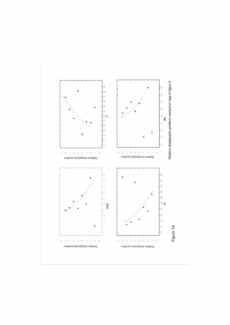
Eight analyses from known stratigraphic positions (Fig. 7) show evidence for
systematic variations in composition. Plots of major and trace elements vs relative
stratigraphic position show that there are consistent variations for several elements
over time (Fig. 14). K2O, Sr and Rb act compatibly, whereas the sequence becomes
more enriched in Y. Other elements do not show discernible trends.
Multi-element normalised diagrams for the Saykahndulaan Valley Formation
(Fig. 15) show strong negative anomalies for Nb, Rb, Sr, P and Cr and positive
anomalies for Th, Ba and Zr. The negative Nb anomaly and high ratio of low-field-
strength-elements (LFSE) to high-field-strength-elements (HFSE) are both features
typical of subduction related volcanism (Fig. 15; Saunders et al., 1980; Wilson, 1989).
The negative Sr and Rb anomalies may be linked to feldspar and biotite fractionation.
The Ba, Zr and Th positive anomalies may be linked to cumulus potassic feldspar and
zircon.
Field observations and petrographic analysis indicate widespread silicification
in the lavas of the Saykhandulaan Valley. Geochemical results support this

15
observation; silica values between 76 and 80% are recorded for three samples (Fig.
11).
Graphical comparison of the trace element composition of an altered rock with
its least-altered-equivalent allows the quantification of metasomatic processes that
affected the altered sample (Grant, 1986). It is assumed that the sample identified as
least-altered-equivalent has not undergone metasomatic alteration, and that, in the
altered sample, Zr, Y, and Nb have remained relatively immobile. Trace element
results for the two samples are plotted against each other, and a line of best fit, the
isocon, is drawn through Zr, Y and Nb points.
Isocon diagrams (Fig. 16; Grant, 1986) of Saykhandulaan Valley rocks show
that altered samples have undergone metasomatic enrichment of Rb, As and Ba.
Zirconium, Y and Nb (along with other elements that plot on or near the isocon) have
lower values in the altered samples than in the least-altered-equivalents; this suggests
mass-gain has occurred, diluting the initial concentrations of these elements. This
provides geochemical evidence that supports the interpretation that volumetrically
significant secondary silicification has occurred. Whilst post-emplacement
metasomatic mobility of trace elements may adversely affect petrogenetic analysis
(e.g. Fig. 13), silicification may have modified the position of samples on the TAS
petrological discrimination diagram, causing compositions to plot in more evolved
fields (Fig. 11).
The Saykhandulaan Valley Formation is chemically similar to the Tsagaan
Nuruu Formation of the OUVG (Figs 11, 15). It also overlaps with the more silicic
parts (>60%) of the Gurvan Morin Höndiy Formation (Fig. 11). Further discussion of
the detailed geochemistry of the OUVG is beyond the scope of this paper, and is
being prepared for separate publication.

16
5 Structural data
The strike of the dominant structural grain in the Saykhandulaan Inlier varies
from 090 in the southwest, to 050 in the southeast and in the NSB. Folding occurs
throughout the inlier and each litho-tectonic domain has a characteristic fold style.
Cleavage is variably developed; the HSB and NSB display a widespread penetrative
cleavage, whilst the MS, OUVG and rocks of the SVLZ are uncleaved or only
affected by spaced cleavage.
At first-order, the NSB consists of regional-scale west-plunging folds, the limbs
of which form a ‘Z’ across the belt (Fig. 4). Second-order folds occur on a scale of
10-100 metres (Fig. 17). These folds plunge to both the east and west. Vergence
varies through the zone, appearing to fan around first-order folds, which are upright.
The HSB features tight-to-isoclinal steeply-inclined folds which plunge to the
east and west and verge south (Fig. 18). Fold closures were not directly observed in
the field, however some apparent closures and low angle truncation can be identified
on the aerial photograph in Fig. 5, and younging criteria prove the existence of fold
hinges (Fig. 18). Other folds were observed on Landsat imagery at the eastern end of
the HSB.
Bedding readings from the MS show gentle, upright, open folds (Fig. 9).
Bedding becomes slightly steeper towards the northern boundary with the HSB (see
cross section on fig. 9).
The folds in the OUVG are the most recognisable on the ground. The three
stratigraphically contiguous formations crop-out in the west in a first-order west-
plunging syncline. The Tsagaan Nuruu Formation crops-out in the centre of this
syncline (Fig. 19) and similar-style M-W folds in rhyolite lavas form positive
topography. The northern limb of the syncline is truncated by east-west oriented

17
faults. Poles to bedding planes (Fig. 19) trace the profile-plane of this syncline. Folds
in OUVG have a slightly different trend from folds elsewhere in the inlier - striking
around 090 (E-W) and plunging west.
Well developed axial planar cleavage characterises pelitic lithologies in both the
NSB and HSB. The different vergence directions of the NSB is reflected in the wide
range of cleavage orientations shown in fig. 17. Cleavage-bedding intersection
lineations which are a proxy for fold hinges, plunge both to the east and west (Fig. 17,
stereoplot 2). Cleavage is dominant in the south-east corner of the NSB, and is
deformed into tight, upright F2 folds. Cleavage in the HSB is sub-parallel to bedding,
and is steep and dominantly north dipping (Fig. 18, stereoplot 2). The coarse and
relatively fresh lithologies of the MS do not contain a well developed cleavage, but
where spaced cleavage was observed, it is near vertical and shows little variation
compared to other domains (Fig. 9).
Remote sensing imagery reveals many faults that cut the Saykhandulaan Inlier,
however, because of the near peneplain relief of the entire inlier, comparatively few
faults have exposed surfaces with visible kinematic indicators. One of the best-
exposed faults is a brittle thrust that defines the northern edge of the HSB in the east,
which has partially consolidated upturned Mesozoic sediments in the footwall (Fig.
20c). Oblique-slip faults are exposed near the southern margins of the molasse
succession. Both of these examples relate to post-Cretaceous fault movements at the
boundary between Palaeozoic strata and Cretaceous basin sequences; although the
faults themselves could have formed earlier, and been subsequently reactivated.
Within the Saykhandulaan Valley Lineament, north-dipping thrust faults crop-out in
the silicified rhyolitic units of the Saykhandulaan Valley Formation (Fig. 20a).
Striations indicating dip-slip movement are locally observed (Figs 21b, 22a). Strike-

18
slip faults are not exposed at the surface and so those recorded in the field were
inferred to be vertical because they from linear depressions and offset contacts and
lithologies (Figs 21b-d).
Inferred normal faults define the eastern and western edges of the inlier. In the
northeast, a normal fault-bound Cretaceous basin lies along strike from the NSB. The
Cretaceous basin is bordered to the south, by the HSB. Where the Saykhandulaan
Valley Lineament Zone joins the basin, there are a number of fault bound troughs
partially covered by onlapping Cretaceous sediments. The basement to these small
depo-centres appears to be faulted blocks of the HSB (Fig. 5).
6 Discussion
The Palaeozoic geological evolution of the Saykhandulaan Inlier is dominated
by siliciclastic sedimentation in a wide variety of environments, with erupted
sequences of volcanic rocks, arc-related plutonism and contractional deformation.
Although major questions remain about the overall geological evolution of Southeast
Mongolia, the lithological and structural data presented here provide the basis for the
first detailed interpretation of basement rocks of Southeast Mongolia, and their terrane
context.
The original depositional environment of the Northern Slate Belt pelitic and
psammitic rocks is interpreted to represent a shelf-to-tidal shallowing-environment.
The stratigraphically lowest parts of the NSB are interpreted to be exposed in the
southeast, in the core of the west-plunging first-order anticline (Fig. 17). The
dominant protolith is mudstone, in upward-fining turbiditic sequences suggesting
deep marine sedimentation. Coarser units and sedimentary features in the southwest,
at higher stratigraphic levels, may represent a prograding fluvial or deltaic
environment with the influence of both fluvial and wave processes. Flame structures

19
in at the base of medium-grained sandstone units suggest loading onto soft, wet mud,
and rapid accumulation of sediment. Swaley cross stratification suggests a Palaeo-
depth of the upper zone of storm-wave influence (Tucker, 1991). The uppermost
parts of the stratigraphy are exposed in the northwest, in the first order syncline (Fig.
17). Psammitic units from throughout the NSB record a cratonic provenance (Fig.
10). The NSB is considered part of the Gobi Altai terrane, which is bordered to the
north by passive margin and cratonic terranes (Fig. 1; Badarch, 2002). It is thus likely
that the cratonic source of the sediments that formed the protoliths to the NSB was in
this northern region.
The volcanic rocks of the Sakhandulaan Valley Formation have undergone
considerable metasomatic alteration, related to fluids moving in the Saykhandulaan
Valley Lineament Zone. The alteration makes accurate interpretation of primary
geochemical signatures problematic though not impossible. Multi-element plots of
trace-elements suggest the succession is volcanic-arc related, and it is chemically
similar to the upper parts of the OUVG. It has, however, been more extensively
deformed and tectonised than the OUVG, and the thickness of the succession suggests
it represents a far less extensive history of volcanism.
The HSB is proximal to the NSB and of a relatively similar metamorphic grade
and protolith. However, the sediments that formed the HSB protolith have a dissected
continental arc provenance and thus are probably south-derived (Fig. 10).
Deformation obscures original sedimentary structures in most areas, but locally
younging evidence was observed. The coarse-conglomerate parts of the HSB, near
the Saykhandulaan valley, are interpreted to represent lower sections of the
stratigraphy than the more voluminous sand- and granule-grade meta-clastic rocks to
the south. The grain size range, cross-stratification and lenticular bedding suggest a

20
sand-dominated braided river system as the depositional environment for the bulk of
the HSB.
The Yasun Eliy-e Formation, though not in direct contact with the rest of the
OUVG, is interpreted to be the oldest volcanic formation as it is the least evolved. It
has lithological similarities to and geochemical overlap with the Gurvan Morin
Höndiy Formation, which is at the base of the contiguous volcanic stratigraphy in the
west (Fig. 5).
In the Ghurvan Morin Höndiy Formation, various granite clasts in fan-
glomerate successions that are intercalated with the volcanics suggest older, exhumed
arc-crust was eroded during the early stages of OUVG volcanicity. It seems likely
that this partially dissected arc could be the same source as that for the sediments that
were the protolith to the HSB. The difference in grain size may suggest that the
depositional environment of the HSB-protolith was further from the eroding source
than was the OUVG. Pillow andesites and lycopsid tree bark in sandstone suggests a
shallow marine to coastal terrestrial palaeo-environment during early stages of the
Oyut Ulaan volcanism.
The Shargyn Moghai Formation is almost entirely dominated by thick trachy-
andesitic sheets with little intervening material, this indicating probable high effusion
rates.
In the Tsagaan Nuruu Formation, the succession is mainly composed of fine- to
medium-grained volcaniclastic deposits. It is unclear whether the felsic lavas that
punctuate this sequence are extrusive or hypabyssal in nature. They appear to have
had a very large areal extent for felsic lavas, and were either particularly hot and of
low viscosity on extrusion; or were injected into the sediments laterally. Sediments in
the upper parts of the succession also suggest a marine marginal environment.

21
The poorly-sorted conglomerates of the MS represent a coarse-grained braided-
river system which drained the OUVG. Fine sand and mudstone sequences may
represent flood-related overbank sequences, or cyclic lake-sedimentation. The MS
occurs unconformably on rocks of the HSB. Provenance data suggest the MS
sediments were derived from an undissected arc of continental to intra-oceanic
affinity (Fig. 10). It is interpreted to be the youngest lithology of the inlier because it
lies unconformably on the HSB and is un-metamorphosed and less deformed.
At least four deformation events are recorded in the Saykhandulaan inlier. D1
is expressed in the NSB as a regional folding and cleavage forming event under lower
greenschist grade metamorphic conditions. D1 folds generally trend ENE. Few
Palaeozoic thrust surfaces were directly observed, however a few thrusts are
tentatively interpreted from metamorphic breaks and fold asymmetry. The upright
first-order folds of the NSB feature several zones of abrupt vergence changes, these
are interpreted to be the effects of either blind-thrusts or thrusts that break the surface,
but are obscured by drift (summary section; Fig. 17). South of the NSB unambiguous
evidence for D1 was not observed.
D2 is a second contractional event, which has affected the entire inlier.
Evidence for D2 consists of F2 folds of S1 cleavage, local crenulation cleavage and
kink banding in the NSB. Quartz veins in the NSB postdate the formation of the S1
cleavage, and may have been emplaced parallel to cleavage planes during D2. The
veins are spatially related to psammite units, which may have deformed in a brittle
manner compared to surrounding pelites, providing conduits for hot SiO2-rich
solutions. Intense folding and greenschist grade metamorphism within the HSB may
have occurred during D1 and/or D2; no F2 folds of cleavage were identified.

22
South of the NSB, the Saykhandulaan Valley Lineament Zone is an important
topographic and structural boundary, separating arc related rocks to the south, from
basin sediments in the north. The zone itself is a two-kilometre wide corridor of
distributed cataclastic deformation, discrete faulting and abundant silicification. It is
interpreted that the SVLZ may represent a south-dipping thrust zone, which brought
the highest-grade rocks of the area (the HSB) to the surface during D1 and/or D2,
entraining slivers of the Saykhandulaan Valley Formation in its base. Some minor
north-dipping thrust surfaces are seen in the SVLZ, these are interpreted to be
backthrusts.
The Molasse Succession and Oyut Ulaan Volcanic Formation have undergone
the least deformation. The Molasse Succession has fold orientations that match those
of the underlying HSB, but the folding is far less intense. Orientations of folds in the
OUVG suggest it may have been affected by N-S shortening in contrast to the NNW-
SSE directed compression seen in the rest of the inlier (Figs. 9, 19). Folding in the
OUVG is interpreted to have occurred during D2 because the sequence lacks cleavage
and evidence for metamorphism which are typical of D1 deformation to the north.
Gentle folding in the MS is interpreted to be a late stage expression of D2.
The Oyut Ulaan intrusion, which is emplaced in the lowermost and least-
evolved parts of the OUVG, is elongate in a direction parallel to the axial trace of
folds in the OUVG. The granite may have been affected by the same N-S directed
shortening as the OUVG, but more evidence is needed to confirm this. Preliminary
unpublished U-Pb zircon dates indicate that the Oyut Ulaan intrusion has a mid-
Carboniferous emplacement age (publication in prep., Blight et al.). This is consistent
with regional evidence for Devonian-Carboniferous arc magmatism throughout
southern Mongolia (Lamb and Badarch, 2001).

23
D3 represents Jurassic-Cretaceous crustal extension widespread in the region
(Graham et al. 2001). Normal faults that cut the inlier and bound Cretaceous basins
around the inlier are likely to have formed during D3.
Some strike slip faults that cut the inlier including the SVLZ cut all older
structures and are therefore suspected of being the youngest faults in the region, and
represent a fourth deformation event, D4 . Recorded sinistral minor faults, and major
faults interpreted to have sinistral offsets trend 030-070, interpreted dextral antithetic
shears trend around 160 (Fig. 22). Orientations of faults recorded in the field, and
interpreted on satellite imagery (Fig. 22) suggest a sinistral Riedel-shear deformation
regime during the Late Cretaceous or Tertiary. These fault displacements may have
been co-genetic with brittle sinistral movements on the nearby Zuunbayan Fault (Fig.
1(Lamb et al., 1999) during the Late Cretaceous or Tertiary.
The recognition that the Saykhandulaan inlier contains a southern volcanic arc
complex and a northern deformed and metamorphosed marine basin assemblage,
sheds light on the regional scale tectonic events that were responsible for crustal
growth in southeast Mongolia. The shortening and metamorphism within the NSB
indicates closure and inversion of the basin between an arc to the south and a
continental block to the north. No evidence for subduction, ophiolite obduction or
accretionary prism development exists during closure of the NSB basin. Therefore, it
is unlikely that the NSB basin was ever floored by oceanic crust and instead is
interpreted to have been ensialic. The polarity of subduction beneath the arc-complex
in the southern inlier was therefore probably north directed, consistent with other
regional interpretations within the CAOB of Palaeo-Asian Ocean closure (Fig.2;
�engör and Natal'in 1996; Badarch et al. 2002). Apart from local en echelon-vein
arrays in the NSB, little evidence was observed for the Palaeozoic large-scale dextral

24
movements postulated in the models of both �engör and Natal’in (1996) and Badarch
et al. (2002). Any major strike-slip displacements within the inlier were probably
focused along the SVLZ and adjacent HSB, which represent the composite terrane
boundary between the Gobi Altai and Mandalovoo terranes.
7 Conclusions
The Saykhandulaan inlier provides a window into the Palaeozoic evolution of
the northern margin of the Palaeo-Asian Ocean in southeast Mongolia. Five major
lithotectonic domains are distinguished that help elucidate the crustal evolution in the
region. More than four thousand metres of volcanic rocks with arc geochemical
signatures are documented, and the intrusion of the mineralised Oyut Ulaan granite
suggest subduction-related magmatism. Two major deformation events are recorded
related to basin closure, inversion and accretion of the Mandalovoo arc-terrane. Basin
closure involved regional scale folding and greenschist grade metamorphism.
Following terrane accretion and cessation of subduction, crustal extension and strike-
slip faulting have further modified the crustal architecture of the inlier. The results
presented here provide a useful framework for understanding the crustal evolution of
adjacent regions within the southeast Gobi mineral belt.
8 Acknowledgements
Research reported in this article was supported by the National Environmental
Research Council, UK, the Society of Economic Geologists, the University of
Leicester and Ivanhoe Mines Ltd. We thank G. Badarch of the Institute of Geology
and Mineral Resources, Mongolian Academy of Sciences, for technical support;
Simon Crockford for excellent fieldwork assistance; and Helen Crowther for critical
reviews of parts of this manuscript.

25
Figure Captions
Fig. 1
Tectonostratigraphic terrane map of South East Mongolia, after Badarch et al.
(2002). Terranes discussed in this study are labelled in bold. Location and offset
sense of Zuunbayan Fault after Lamb et al. (1999). Location of Solonker Suture after
Xaio et al. (2003) Location of terrane boundaries in China not shown because of
uncertain correlations there. Inset maps show regional political boundaries (top) and
locations of Precambrian cratons and terrane collage comprising Central Asian
Orogenic Belt (CAOB) after �engör and Natal’in (1996) and Helo et al. (2006);
bottom) .
Fig. 2
Two interpretations of tectonic setting in southeast Mongolia in Devonian-
Carboniferous time.
a) Early Carboniferous palaeotectonic reconstruction of the craton-proximal
section of the Tuva-Mongol arc, after �engör and Natal’in (1996). Growth of the arc
takes place via accretion above northward dipping subduction zone, and strike-slip
duplication along the arc front. The South Mongolian Unit (marked SMU) is a
subduction-accretion complex, which represents the majority of the Palaeozoic crustal
growth in southeast Mongolia. Box A shows approximate position of the study area.
b) Simplified reconstruction of Devonian-Carboniferous terrane positions in
South Mongolia, after Badarch et al. (2002). The diagram shows two northward
dipping subduction zones beneath parallel E-W island arcs. The Mandalovoo (MOV)
and Gurvansayhan (GV) terranes represent laterally contiguous sections of the same
arc. Box A shows approximate position of the field area (Fig 3).

26
Fig. 3
Landsat image of Saykhandulaan Inlier, location shown in Fig. 1. Litho-
tectonic domains marked: NSB - Northern Slate Belt; SVS - Saykhandulaan valley
sequence; HSB - High-strain steep belt; MS - Molasse Sequence; OUVG - Oyut
Ulaan Volcanic Group; OUI - Oyut Ulaan intrusion. Areas outside of marked litho-
tectonic domains contain Mesozoic-Cenozoic sedimentary cover sequences and lavas.
Locations of Figs. 4 and 5 shown.
Fig. 4
Interpreted Landsat image of the Northern Slate Belt. Dominant NE-SW
structural grain emphasised with fine lines. Interpreted faults shown with heavy
dashed lines. Locations of transect segments shown.
Fig. 5
a. Aerial photograph of the southern part of the field area. Location of Fig.
shown in Fig. 3. Notice dominant ENE-WSW grain.
b. Interpretation of Fig. 5a showing litho-tectonic units: HSB - High strain
steep belt, MS - Molasse Sequence; OUVG - Oyut Ulaan Volcanic Group; OUI -
Oyut Ulaan intrusion. Dominant structural grain marked with fine lines. Faults,
observed and interpreted, marked with thicker lines. Locations of transect lines
shown.
Fig. 6
a-f) Stratigraphic logs from southern zone of Northern Slate Belt. Coarser
lithologies occur in south of belt where psammitic bands are thicker and more
widespread. g) fine grained psammite and pelite interbeds similar to log c. h) flame
structure preserved in relatively un-metamorphosed sandstone and mudstone from log
f.

27
Fig. 7
a) Map of large en-echelon quartz vein array visible in ‘a’ (location noted on
Fig. 4) with arrows to show interpreted dextral shear sense. b) View NE of major
quartz vein outcrop. c) View SE from top of vein outcrop hill, many more large veins
in distance d) View NE of metre-scale quartz veins.
Fig. 8
Stratigraphic columns for Saykhandulaan Valley Volcanic Formation, grain size
and lithological features shown. Samples taken for analysis marked. Inset map of
Saykhandulaan Valley Volcanic Formation outcrop (see Fig. 5 for location). Fault
orientations and sense of movement inferred from topographic features and contact
offsets.
Fig. 9
Lithological logs and photographs from Molasse Sucession showing vertical
transition from conglomerates to intercalated fine-sand and mudstones. Photograph
of horizontal intercalated sandstone and mudstone beds Logs and photograph located
on inset transect line. Stereoplot of MS structural data Location of transect shown on
Fig. 5
Fig. 10
Sandstone compositional data from Northern Slate Belt (NSB), High Strain Belt
(HSB) and Molasse Succession (MS). Provenance fields from Marsaglia and
Ingersoll (1992).
Fig. 11
Total Alkalis Silica (TAS) diagram after Le Bas et al. (1986) for Saykhandulaan
Valley Formation Volcanic rocks. Fields indicate general compositions of Oyut Ulaan
Volcanic Group rocks by formation.

28
Fig. 12
Harker variation diagrams of Al2O3, Fe2O3, MgO, CaO, Rb, Ba, Sr, K2O, Na2O
versus SiO2. Fields indicate general composition of Gurvan Morin Höndiy Formation
(with SiO2 values >60%) and Tsagaan Nuruu Formation.
Fig. 13
Log Ba versus log Sr diagram for Saykhandulaan Valley Formation Volcanic
rocks showing fractionation with apparent feldspars and biotite control. Inset -
fractional crystallisation vectors for plagioclase, K-feldspar, biotite, horneblende,
orthopyroxene, clinopyroxene using partition coefficients for rhyolitic liquids from
Rollinson (1993).
Fig. 14
Relative stratigraphic position versus Na2O+K2O, Y, Sr, Rb for Saykhandulaan
Valley Formation Volcanic rocks.
Fig. 15
Multi-element diagram of trace elements for Saykhandulaan Valley Formation
volcanic rocks. Fields indicate general composition of Gurvan Morin Höndiy
Formation (with SiO2 values >60%) and Tsagaan Nuruu Formation.
Fig. 16
Isocon diagrams of altered samples versus least-altered-equivalents for
Saykhandulaan Valley Formation Volcanic rocks.
Fig. 17
Individual structural transects through Northern Slate Belt and combined
summary section incorporating all lines. Bedding traced by form lines showing folds.
Map shows location of transect line segments. Stereoplot 1. - NSB poles-to-bedding-
planes on lower hemisphere equal-area stereoplot. Stereoplot 2 - NSB poles-to-

29
cleavage-planes on lower hemisphere equal-area stereoplot. Summary section
demonstrates kilometre scale first order folding within NSB.
Fig. 18
Transect line through HSB Bedding and cleavage traced by form lines.
Interpreted folds shown by dashed lines. Location of transect shown on Fig. 5.
Stereoplot 1) HSB poles-to-bedding-planes on lower hemisphere equal-area
stereoplot. Stereoplot 2) HSB poles-to-cleavage-planes on lower hemisphere equal-
area stereoplot. Photo a. shows flattened clasts and spaced cleavage in meta-
conglomerate of HSB, pen for scale.
Fig. 19
Transect line through Oyut Ulaan Volcanic Group, upper parts of Shargyn
Moghai Formation (to left) comprise north limb of regional syncline that dips to south
under Tsagaan Nuruu Formation which is deformed into m-w folds in core of syncline
(to right). Location of transect shown on Fig. 5. Stereoplot 1. - OUVG poles-to-
bedding-planes on lower hemisphere equal-area stereoplot.
Fig. 20
a) Backthrust zone in Saykhandulaan Valley Formation silicified rhyolite. View to
west, hammer for scale. b) Detail of thrust surface showing down-dip slickenlines,
hammer for scale. c) High Strain Belt greenschist-grade meta-conglomerates (left)
thrust over partially consolidated near-vertical dipping Cretaceous sediments (right)
View to west.
Fig. 21
a) Orientations of thrust faults - (unbroken line) and minor back-thrusts - (dashed line)
from the Saykhandulaan Valley Lineament Zone. Striations on fault surfaces

30
(crosses) indicate dominant dip-slip motion. b) Oblique-slip and strike-slip faults
from back-thrusted zone in Saykhandulaan Valley. Striations on fault surfaces
indicate dominant strike-slip motion. c) Orientations of brittle faults with apparent
sinistral offsets from the whole inlier. d) Orientations of brittle faults with apparent
dextral offsets from the whole inlier.
Fig. 22
Landsat image of Saykhandulaan Inlier. Interpreted and measured faults from
inlier shown with movement sense. Inset sinistral Riedel-shear model shows
predicted orientations of major and antithetic shears and normal faults. The
orientation of Mezozoic regional sinistral movements compares well with array of
strike- and oblique-slip faults identified in this study.
Fig. 23
Evolutionary model to illustrate the development of the Saykhandulaan Inlier from
the Devonian to the end of the Permian.
a. Deposition of the protolith to the NSB occurs in a back-arc basin fed by
sediments from the passive margin of a craton to the north. In the south, a
rifted continental arc is eroded and provides sediments for the protolith to the
HSB.
b. Volcanism continues, sediments that compose the HSB protolith are buried
and N-S compressive deformation begins (D1) as back-arc basin closes.
c. D1 strain is focussed in the HSB, which is tightly folded at depth. Thrusting
ensues, with the main thrust zone exploiting the Saykhandulaan Formation as
a brittle décollement. The HSB is thrusted over the NSB which displays
upright folds, and discrete zones of northern vergence, interpreted to be related

31
to further south dipping thrusts. The Saykhandulaan Formation forms a
duplex in the thrust zone. To the south, the lower lavas of the OUVG are
erupted and interbedded with conglomerates derived from the dissected old
continental-arc crust.
d. A second deformation with similar principle stress axes folds the newly
formed OUVG and the S1 cleavage in the NSB is folded proximal to the
Saykahdulaan Thrust. Back-thrusting occurs in the thrust zone and cuts the
HSB. Fluid flow along the Saykhandulaan thrust silicifies the lithologies
within the zone, and is focussed in giant quartz veins in parts of the NSB. To
the south the Oyut Ulaan intrusion is emplaced and the OUVG is uplifted and
eroded.
e. Some oblique slip motion occurs on faults formed parallel to steep cleavage
domains in the NSB and HSB. Parts of the OUVG are displaced laterally out
of section. The OUVG forms the sediment source for intermontane molasse
basins to its north. Subsequently molasse is gently folded and acquires a
vague space cleavage.

32
9 References
Badarch, G., Cunningham, W. D., Windley, B. F., 2002. A new terrane subdivision
for Mongolia: Implications for the Phanerozoic crustal growth of Central Asia.
Journal of Asian Earth Sciences, 21: 87 - 110.
Barry, T.L. and Kent, R.W. (Editors), 1998. Cenozoic magmatism in Mongolia and
the origin of Central and East Asian basalts. American Geophysical Union,
Washington, DC, 347-364 pp.
Cunningham, W.D., 1998. Lithospheric controls on late Cenozoic construction of the
Mongolian Altai. Tectonics, 17(6): 891-902.
Graham, S.A. et al., 2001. Sedimentary Record and Tectonic Implications of
Mesozoic Rifting in Southeast Mongolia. GSA Bulletin, 113(12): 1560-1579.
Grant, J.A., 1986. The Isocon Diagram: A Simple Solution to Gresens' Equation for
Metasomatic Alteration. Economic Geology, 81: 1976-1982.
Helo, C. et al., 2006. Geochemical signature of palaeozoic accretionary complexes of
the Central Asian Orogenic Belt in southern Mongolia, constraints on arc
environments and crustal growt. Chemical Geology, 227: 236-257.
Lamb, M.A., Hanson, A.D., Graham, S.A., Badarch, G. and Webb, L.E., 1999. Left-
lateral sense offset of upper Proterozoic to Paleozoic features across the Gobi
Onon, Tost, and Zuunbayan faults in southern Mongolia and implications for
other Central Asian faults. Earth and Planetary Science Letters, 173(3): 183-
194.
Le Bas, M.J., Le Maitre, R.W., Streckeisen, A. and Zanettin, B., 1986. A chemical
classification of volcanic rocks based on the total alkali-silica diagram. Journal
of Petrology, 27(3): 745-750.

33
Marsaglia, K.M. and Ingersoll, R.V., 1992. Compositional trends in arc-related, deep-
marine sand and sandstone; a reassessment of magmatic-arc provenance.
Geological Society of America Bulletin, 104: 1637-1649.
Meng, Q., Hu, J., Jin, J., Y., Z. and Xu, D., 2003. Tectonics of the late Mesozoic wide
extensional basin system in the ChinaMongolia border region. Basin Research,
15(3): 397-415.
Perello, J. et al., 2001. Oyu Tolgoi, Mongolia; Siluro-Devonian porphyry Cu-Au-
(Mo) and high-sulfidation Cu mineralization with a Cretaceous chalcocite
blanket. Economic Geology, 96(6): 1407-1428.
Rollinson, H., 1993. Using geochemical data: evaluation, presentation, interpretation.
Longman, 352 pp.
Saunders, A.D., Tarney, J. and Weaver, S.D., 1980. Transverse geochemical
variations across the antarctic penninsula: implications for the genesis of calc-
alkaline magmas. Earth and Planetary Science Letters, 46: 344-360.
Sengor, A.M.C. and Natal'in, B.A., 1996. Palaeotectonics of Asia: fragments of a
synthesis. In: A. Yin and M. Harrison (Editors), The Tectonic Evolution of
Asia. Cambridge University Press, Cambridge, pp. 486-640.
Tucker, M.E., 1991. Sedimentary Petrology: an introduction to the origin of
sedimentary rocks. Blackwell Science, Oxford, 260 pp.
Watanabe, Y. and Stein, H.J., 2000. Re-Os ages for the Erdenet and Tsagaan Suvarga
porphyry Cu-Mo deposits, Mongolia, and tectonic implications. Economic
Geology, 95(7): 1537-1542.
Wilson, M., 1989. Igneous petrogenesis; a global tectonic approach. Unwin Hyman,
London, 466 pp.

34
Xiao, W., Windley, B.F., Hao, J. and Zhai, M., 2003. Accretion leading to collision
and the Permian Solonker suture, Inner Mongolia, China: Termination of the
central Asian orogenic belt. Tectonics, 22(6).
Xiao, W. et al., 2004. Palaeozoic accretionary and convergent tectonics of the
southern Altaids: implications for growth of Central Asia. Journal of the
Geological Society of London, 161: 339-342.