Cruise Results NOAA FRV Gloria Michelle Gulf of Maine ... TOTAL WEIGHT (kg) 5-1 4 42 59 69 48 191...
8
10 October 2012 CRUISE RESULTS NOAA FRV Gloria Michelle Gulf of Maine Northern Shrimp Survey GM 12-03, Parts I-IV 22 July – 18 August 2012 INTRODUCTION This report summarizes results of the 2012 survey cruise for northern shrimp, Pandalus borealis, in the western Gulf of Maine. This was the 29 th survey conducted by the Northeast Fisheries Science Center (NEFSC) in cooperation with the Northern Shrimp Technical Committee of the Atlantic States Marine Fisheries Commission. The survey is designed to provide data required for annual stock assessments and related tasks. METHODS The survey cruise was conducted from 22 July – 18 August 2012 aboard FRV Gloria Michelle, a 72- foot, 96 gross registered ton (GRT) stern trawler powered by a 365 horsepower Caterpillar diesel engine. Fieldwork was overseen by NEFSC staff. Participants included personnel from the NEFSC and state agencies of Maine and Massachusetts (see Appendix I). A stratified random sampling design was used to select stations sampled during the survey (Figure 1). The number of stations allocated to each stratum was roughly proportional to the area of that stratum. Additional non-random stations were also occupied. Field work was conducted during daylight hours in recognition of diel changes in northern shrimp availability. The survey was conducted in four parts: Part I was during 22 – 27 July; Part II, 30 July – August 3; Part III, 6 - 10 August; Part IV, 13 - 18 August 2012. Locations of stations sampled during each part are given in Figure 2. The vessel departed Woods Hole, MA and made planned intermediate port calls in Portland, ME and Gloucester, MA before returning to Woods Hole, MA. At each station, a 15 minute tow was made at a vessel speed of two knots. Gear consisted of a four- seam modified commercial shrimp trawl fished at a scope of 3:1 in depths up to and including 85 fathoms; 250 fathoms of wire in depths between 86 and 100 fathoms; and a scope of 2.5:1 in depths greater than 100 fathoms. Reference/hull surface temperatures and meteorological observations were recorded at each station. A Vemco Minilogger was used to record the bottom temperatures during the survey. Northstar Technical Inc. Netmind Trawl Monitor System was used to monitor trawl gear performance on most survey tows. Doorspread and bottom contact of the trawl were transmitted and logged electronically. A Seabird SBE 19 CTD was attached to the headrope of the net on each tow to collect temperature, depth, and conductivity data. This was the first time deploying a SBE 19 during a shrimp survey and its use was considered experimental.
Transcript of Cruise Results NOAA FRV Gloria Michelle Gulf of Maine ... TOTAL WEIGHT (kg) 5-1 4 42 59 69 48 191...

10 October 2012
CRUISE RESULTS
NOAA FRV Gloria Michelle Gulf of Maine Northern Shrimp Survey
GM 12-03, Parts I-IV 22 July – 18 August 2012
INTRODUCTION
This report summarizes results of the 2012 survey cruise for northern shrimp, Pandalus borealis, in the western Gulf of Maine. This was the 29th survey conducted by the Northeast Fisheries Science Center (NEFSC) in cooperation with the Northern Shrimp Technical Committee of the Atlantic States Marine Fisheries Commission. The survey is designed to provide data required for annual stock assessments and related tasks.
METHODS
The survey cruise was conducted from 22 July – 18 August 2012 aboard FRV Gloria Michelle, a 72-foot, 96 gross registered ton (GRT) stern trawler powered by a 365 horsepower Caterpillar diesel engine. Fieldwork was overseen by NEFSC staff. Participants included personnel from the NEFSC and state agencies of Maine and Massachusetts (see Appendix I).
A stratified random sampling design was used to select stations sampled during the survey (Figure 1). The number of stations allocated to each stratum was roughly proportional to the area of that stratum. Additional non-random stations were also occupied. Field work was conducted during daylight hours in recognition of diel changes in northern shrimp availability. The survey was conducted in four parts: Part I was during 22 – 27 July; Part II, 30 July – August 3; Part III, 6 - 10 August; Part IV, 13 - 18 August 2012. Locations of stations sampled during each part are given in Figure 2. The vessel departed Woods Hole, MA and made planned intermediate port calls in Portland, ME and Gloucester, MA before returning to Woods Hole, MA.
At each station, a 15 minute tow was made at a vessel speed of two knots. Gear consisted of a four-seam modified commercial shrimp trawl fished at a scope of 3:1 in depths up to and including 85 fathoms; 250 fathoms of wire in depths between 86 and 100 fathoms; and a scope of 2.5:1 in depths greater than 100 fathoms. Reference/hull surface temperatures and meteorological observations were recorded at each station. A Vemco Minilogger was used to record the bottom temperatures during the survey. Northstar Technical Inc. Netmind Trawl Monitor System was used to monitor trawl gear performance on most survey tows. Doorspread and bottom contact of the trawl were transmitted and logged electronically. A Seabird SBE 19 CTD was attached to the headrope of the net on each tow to collect temperature, depth, and conductivity data. This was the first time deploying a SBE 19 during a shrimp survey and its use was considered experimental.

A 2 kilogram (kg) sample of Pandalid shrimp was collected at most stations to determine species composition. Length frequency measurements were collected for northern shrimp (mid- dorsal carapace length, rounded down to the nearest tenth of a millimeter) in addition to sex and female spawning condition (Rasmussen 1953; McCrary 1971). When less than 2 kg of shrimp was caught at a station, the entire catch was processed as described above.
For other species of invertebrates and finfish, standard NEFSC bottom trawl survey techniques (Azarovitz 1981, Grosslein 1969) were used to process the catch. Bony fish were measured to the nearest centimeter (cm) to the end of the central caudal ray; American lobsters were measured in millimeters (mm) from eye socket to end of carapace; and carapace width (cm) was recorded for crabs. Bivalves were measured by shell height (cm) and cephalopods were measured by mantle length (cm). All species weights were recorded to the nearest 0.001 kg. The remainder of the catch (miscellaneous invertebrates, trash, etc.) was recorded by volume. Total and individual weights and lengths information for shrimp and all other measured species were recorded directly into the Fisheries Scientific Computer System (FSCS), version 2.0.
RESULTS
A total of 80 stations were occupied. Northern shrimp were collected at 71 stations (Table 1). There were 20 non-random fixed stations. Stratum 10, tow 2 had the highest total number of northern shrimp while the lowest number was taken in Stratum 9, tow 1.
All shrimp, finfish, and select invertebrate data have been audited and archived in computer data files (total weight, number, and length frequencies). Scientific sample collections are summarized in Table 2. This information is available on request (refer to NEFSC Survey Master Data files Cruise Code 201270).
REFERENCES
Azarovitz, T. R. 1981. A brief historical review of the Woods Hole Laboratory trawl survey time series. Can. Spec. Publ. Fish. Aquat. Sci., 58: 62-67.
Grosslein, M. D. 1969. Groundfish survey methods. NMFS, Woods Hole, Lab. Ref. Doc. 69-2, 34p.
McCrary, J. A. 1971. Sternal spines as a characteristic for differentiating between females of some Pandalidae. J. Fish. Res. Board Can., 28: 98-100.
Rasmussen, B. 1953. On the geographical variation in growth and sexual development of the deep-sea prawn (Pandalus borealis kr.). Norway Fish. Mar. Invest. Rep., 10 (3); 1-160.
_________________________________________________________________________ For further information contact Peter Chase, National Marine Fisheries Service, Northeast Fisheries Science Center, Woods Hole, Massachusetts 02543-1097. Phone (508) 495-2348; FAX (508) 495-2115; [email protected]. The Cruise Results can be viewed at NEFSC Ecosystems Survey Branch Shrimp Cruise Reports
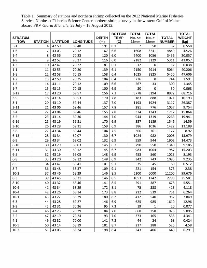
Table 1. Summary of stations and northern shrimp collected on the 2012 National Marine Fisheries Service, Northeast Fisheries Science Center northern shrimp survey in the western Gulf of Maine aboard FRV Gloria Michelle, 22 July – 18 August 2012.
STRATUM-TOW STATION LATITUDE LONGITUDE
DEPTH (m)
BOTTOM TEMP
(C)
TOTAL No. <= 22mm
TOTAL No. > 22mm
TOTAL NUMBER
TOTAL WEIGHT
(kg) 5-1 4 42 59 69 48 191 8.1 2 50 52 0.558 1-6 7 43 03 70 12 167 6.6 1608 3241 4849 42.26 1-4 8 42 56 70 23 120 6.0 2400 1056 3456 20.057 1-9 9 42 52 70 27 116 6.0 2182 3129 5311 43.057 1-3 10 42 47 70 22 81 6.1 12 0 12 0.038 1-1 11 42 55 70 20 139 6.1 2150 2914 5064 40.206 1-8 12 42 58 70 15 158 6.4 1625 3825 5450 47.606 1-2 13 42 59 70 25 104 6.4 736 8 744 1.591 1-5 14 43 11 70 12 109 6.6 267 33 300 1.345 1-7 15 43 15 70 15 100 6.9 30 0 30 0.068 3-12 17 43 20 69 57 156 7.3 3778 5194 8972 68.716 3-9 18 43 14 69 53 170 7.8 183 888 1071 10.193 3-1 20 43 10 69 44 137 7.0 1193 1924 3117 26.387 3-11 21 43 06 69 46 157 7.8 281 776 1057 9.754 3-4 22 43 04 69 46 155 7.8 374 1343 1717 15.864 3-5 23 43 14 69 30 144 7.0 944 1319 2263 19.941 6-16 25 43 19 69 21 170 6.9 357 1189 1546 14.59 3-10 26 43 28 69 31 159 6.9 386 1036 1422 13.189 3-8 27 43 34 69 44 104 7.5 366 761 1127 8.92 6-13 28 43 34 69 07 130 6.7 1024 982 2006 13.979 6-9 29 43 34 69 02 132 6.9 959 944 1903 14.473 6-10 30 43 29 69 03 145 6.7 790 550 1340 9.185 6-11 31 43 30 69 12 145 6.7 983 1004 1987 15.203 6-5 32 43 19 69 05 148 6.9 453 560 1013 8.193 6-8 33 43 20 69 12 148 6.9 342 743 1085 9.235 8-5 34 43 47 68 41 101 9.1 35 45 80 0.512 8-7 36 43 48 68 37 109 9.1 221 154 375 2.38 10-2 37 43 46 68 29 146 8.5 5200 6000 11200 99.676 8-3 39 43 45 68 31 146 8.5 1053 1742 2795 25.581 8-10 40 43 32 68 46 141 8.5 291 387 678 5.551 10-6 41 43 34 68 29 172 8.1 75 338 413 4.118 10-4 42 43 26 68 14 173 8.8 212 539 751 6.264 10-1 43 43 22 68 29 180 8.2 412 540 952 7.849 6-3 44 43 28 69 27 146 6.9 625 985 1610 12.96 2-3 45 42 31 70 26 95 7.3 19 1 20 0.077 2-4 46 42 23 70 29 84 7.0 668 258 926 5.095 2-2 47 42 19 70 24 93 7.0 373 165 538 4.341 4-1 49 42 32 70 00 141 7.2 44 24 68 0.424 10-5 50 43 14 68 19 181 8.7 237 288 525 4.58 10-3 51 43 03 68 24 198 8.4 243 406 649 6.291

STRATUM-TOW STATION LATITUDE LONGITUDE
DEPTH (m)
BOTTOM TEMP
(C)
TOTAL No. <= 22mm
TOTAL No. > 22mm
TOTAL NUMBER
TOTAL WEIGHT
(kg) 8-1 52 43 06 68 40 179 8.5 25 198 223 2.404 8-8 53 43 12 68 47 166 8.7 325 551 876 8.35 8-4 54 43 09 68 47 169 8.7 75 358 433 4.557 8-2 55 43 04 68 43 179 8.5 5 51 56 0.623 8-9 56 42 58 68 50 175 8.8 26 124 150 1.564 6-12 57 42 54 69 04 179 8.2 5 27 32 0.338 6-4 58 43 03 69 12 185 7.5 93 387 480 5.063 6-15 60 43 08 69 09 183 8.2 444 1608 2052 20.889 6-2 62 43 04 69 29 151 6.9 98 242 340 2.945 6-7 63 42 58 69 25 176 7.2 156 660 816 7.855 6-14 65 42 54 69 17 155 7.0 22 149 171 1.718 6-6 66 42 47 69 27 159 7.9 6 93 99 1.078 6-1 67 42 46 69 12 148 7.2 6 9 15 0.123 7-7 69 42 38 69 16 206 8.4 12 9 21 0.151 4-4 73 42 38 69 58 181 7.9 310 536 846 7.137 5-3 74 42 49 69 56 207 8.4 12 122 134 1.464 5-7 75 42 53 69 45 208 8.2 28 320 348 3.668 3-2 76 42 54 69 35 163 8.1 20 109 129 1.213 3-6 77 42 49 69 35 173 8.1 13 103 116 1.194 5-8 78 42 48 69 39 210 8.2 1 22 23 0.283 5-5 79 42 44 69 33 216 8.2 3 53 56 0.618 5-6 81 42 24 69 51 226 8.3 12 64 76 0.778 7-8 83 42 26 69 03 217 8.4 1 14 15 0.063 9-4 84 42 31 68 47 200 8.3 3 15 18 0.216 8-6 85 42 45 68 44 198 8.5 3 63 66 0.757 9-1 86 42 25 68 42 196 8.4 1 3 4 0.056 9-2 89 42 22 68 53 205 8.3 2 13 15 0.175 9-3 90 42 20 68 56 212 8.3 2 18 20 0.25 7-1 91 42 18 69 02 209 8.3 2 28 30 0.352 7-4 92 42 06 69 11 185 8.0 1 16 17 0.219 5-2 96 42 03 69 44 193 7.9 6 15 21 0.192

Table 2. Miscellaneous scientific collections made on the 2011 National Marine Fisheries Service, Northeast Fisheries Science Center northern shrimp survey in the western Gulf of Maine aboard FRV Gloria Michelle, 22 July – 18 August 2012.
Investigator & Affiliation Samples Saved Approximate Number Age Samples, NMFS, NEFSC, Woods Hole, MA Goosefish 12 vertebrae
White Hake 307 otoliths

Figure 1. Northern shrimp survey strata and observed distribution of catch per tow (kg) of northern shrimp collected during the 2012 National Marine Fisheries Service, Northeast Fisheries Science Center northern shrimp survey in the western Gulf of Maine aboard FRV Gloria Michelle, 22 July – 18 August 2012.

Figure 2. Trawl hauls made during the 2012 National Marine Fisheries Service, Northeast Fisheries Science Center northern shrimp survey in the Gulf of Maine aboard FRV Gloria Michelle, 22 July – 18 August 2012.

Appendix I. Participants on the 2012 National Marine Fisheries Service, Northeast Fisheries Science Center northern shrimp survey cruise in the western Gulf of Maine aboard FRV Gloria Michelle, 22 July to 18 August 2012.
National Marine Fisheries Service, NEFSC, Woods Hole, MA Peter Chase, Chief Scientist1, 2 Jakub Kircun2, Chief Scientist3,4 Heath Cook3,4 Paul Kostovick1 TK Arbusto1
Cristina Bascunan1
Grace Thorton4
Anne Richards2 Sandy Sutherland3
Heidi Marotta2
MA Division of Marine Fisheries, Gloucester, MA Nick Buchan3 Christopher Wood4
ME Department of Health and Human Services, Augusta, ME Charles Woodbury3
ME Department of Marine Resources, Boothbay, ME Lessie White1 Michelle Mason Webber2
Gulf of Maine Research Institute, Portland, ME Kim Little4
Seagrant Fellow, Washington, DC Fern Gibbons3
Volunteers Caroline Casals1,4
Julia Beaty2
Gloria Michelle Crew LT Anna-Liza Villard-Howe1,2,3,4 ENS Shannon Hefferan1,2,3,4 George Morton1,2,3,4 LT Carl Rhodes1, 2 Jeffrey LaMarche3 LT Sarah Duncan4 1 22 – 27 July 2 30 July – 3 August 3 6 – 10 August 4 13 – 18 August

![chem463 lecture6 electrodes and potentiometry · Ksp [Cl-] = 1.8 x 10⁻¹⁰ 0.0212 =8.5 x 10⁻⁹M E = 0.558 + 0.05916 log (8.5 x 10⁻⁹) = 0.081 V Ion-Selective Electrodes – how they work](https://static.fdocuments.us/doc/165x107/6060a9d63b974f1da40c817e/chem463-lecture6-electrodes-and-potentiometry-ksp-cl-18-x-10-10-00212-85.jpg)