Cruise Report - bodc.ac.uk
16
Cruise Report FDS Submarine Channels RV Koca Piri Reis 9 th -26 th May 2010 Flow dynamics and sedimentation in an active submarine channel: a process-product approach Principal Scientist J Peakall 2012 School of Earth and Environment University of Leeds, Leeds, LS2 9JT Tel: +44 (0)113 343 5205 Email: [email protected]
Transcript of Cruise Report - bodc.ac.uk

Cruise Report
FDS Submarine Channels
RV Koca Piri Reis
9th-26th May 2010
Flow dynamics and sedimentation in an active submarine channel:
a process-product approach
Principal Scientist
J Peakall
2012
School of Earth and Environment University of Leeds, Leeds, LS2 9JT Tel: +44 (0)113 343 5205 Email: [email protected]

2
DOCUMENT DATA SHEET
AUTHOR
Peakall, J. et al. PUBLICATION
DATE 2012 TITLE
RV Koca Piri Reis cruise 9th-26th May 2010 REFERENCE
University of Leeds, FDS Submarine Channels Cruise Report ABSTRACT
The primary aim of the FDS Submarine cruise was to collect high-resolution velocity data from an active submarine channel, using NERC’s Autosub 3 autonomous submarine. Data was collected from a saline underflow that passes through a channel network on the Black Sea shelf immediately north of the Bosphorus Strait. Such data for submarine channels is unknown due to the difficulty of measuring such flows which are typically infrequent and destructive. Furthermore, as a result of sea-level rise most flows of this type are out of equilibrium with their bounding topography. This part of the Black Sea is a unique area where a 10-15 m thick underflow of dense Mediterranean water flows across the Black Sea shelf through a series of sinuous channels. Furthermore, this channel network was only initiated round 6,000 years ago when sea-level approached its present level, and flows and channel network have co-evolved together to form a system in equilibrium. Such velocity data is critical for generating predictive models of these deep-sea channels which are the primary transporters of sediment, carbon and pollutant fluxes to the deep sea, and whose ancient deposits form major hydrocarbon reservoirs.
Despite a range of problems including mobilisation, adverse weather, and instrumentation failure the cruise was ultimately successful in providing the first detailed dataset of the three-dimensional flow field of a submarine channel. Cruise highlights included: 1) ADCP velocity data collected on a series of Autosub 3 lines around a major channel bend, 2) collection of CTD data across a series of transects normal to the channel, and 3) collection of grab samples from the base of the channel revealing complex spatial patterns in the seafloor environment. KEYWORDS
Submarine channel, density current, gravity current, Autosub, RV Koca Piri Reis ISSUING ORGANISATION
School of Earth and Environment University of Leeds, Leeds, LS2 9JT Tel: 0113 343 5205 Email: [email protected]

3
CONTENTS
Page
Cruise personnel 4 Itinerary 5 Scientific objectives 5 Cruise narrative 6 Summary of data 12 Station log 13 Track charts 16

4
CRUISE PERSONNEL
SCIENTIFIC PARTY
PEAKALL, J (Principal Scientist) University of Leeds, UK PARSONS, D.R. University of Leeds, UK SUMNER, E. National Oceanography Centre, UK WYNN, R.B. National Oceanography Centre, UK HISCOTT, R.N. Memorial University of Newfoundland, Canada WEBB, A. NMFD AUV team, NOC WHITE, D. NMFD AUV team, NOC PERRETT, J. NMFD AUV team, NOC MOBILISATION / DEMOBILISATION AUV TEAM
ROBERTS, R. NMFD AUV team, NOC EVANS, J. NMFD AUV team, NOC TURNER, D. NMFD AUV team, NOC Plus the SHIP MASTER, OFFICERS AND CREW
No individual listing available

5
ITINERARY
Setup in Urla, Turkey 9th-13th May 2010 Departed Urla, Turkey 14th May 2010 Arrived Istanbul via Marmara, 18th May 2010 Returned Urla, 26th May 2010 SCIENTIFIC OBJECTIVES
This research cruise was focused on the three-dimensional flow dynamics of submarine channels. Flows in such channels are driven by gravity currents on ocean floors. Such channels are very important as transporters of coarse-grained sediment, and other fluxes such as carbon, anthropogenic pollutants etc. The deposits of submarine channels also form important reservoirs for hydrocarbons, particularly offshore of modern ocean shelves. The Bosphorus outlet into the Black Sea provides a spectacular example of a subaqueous channel network through which a pseudo-steady gravity current runs for almost all of the time. This gravity-current is caused by hyper-saline Mediterranean water entering the brackish Black Sea as an underflow. The primary cruise objective was to obtain high-quality velocity data from this channelized system. This was achieved using an autonomous underwater vehicle, Autosub 3, which allowed measurements to be taken throughout the full depth of the flow. Allied objectives were to: obtain detailed density distributions across the channel at multiple cross-sections; and, grab sampling in order to reveal the spatial patterns of seafloor sedimentation. A more detailed coring programme to assess longer-term sedimentary processes was a subsidiary objective, dependent on progress on the key objectives.
6
CRUISE NARRATIVE
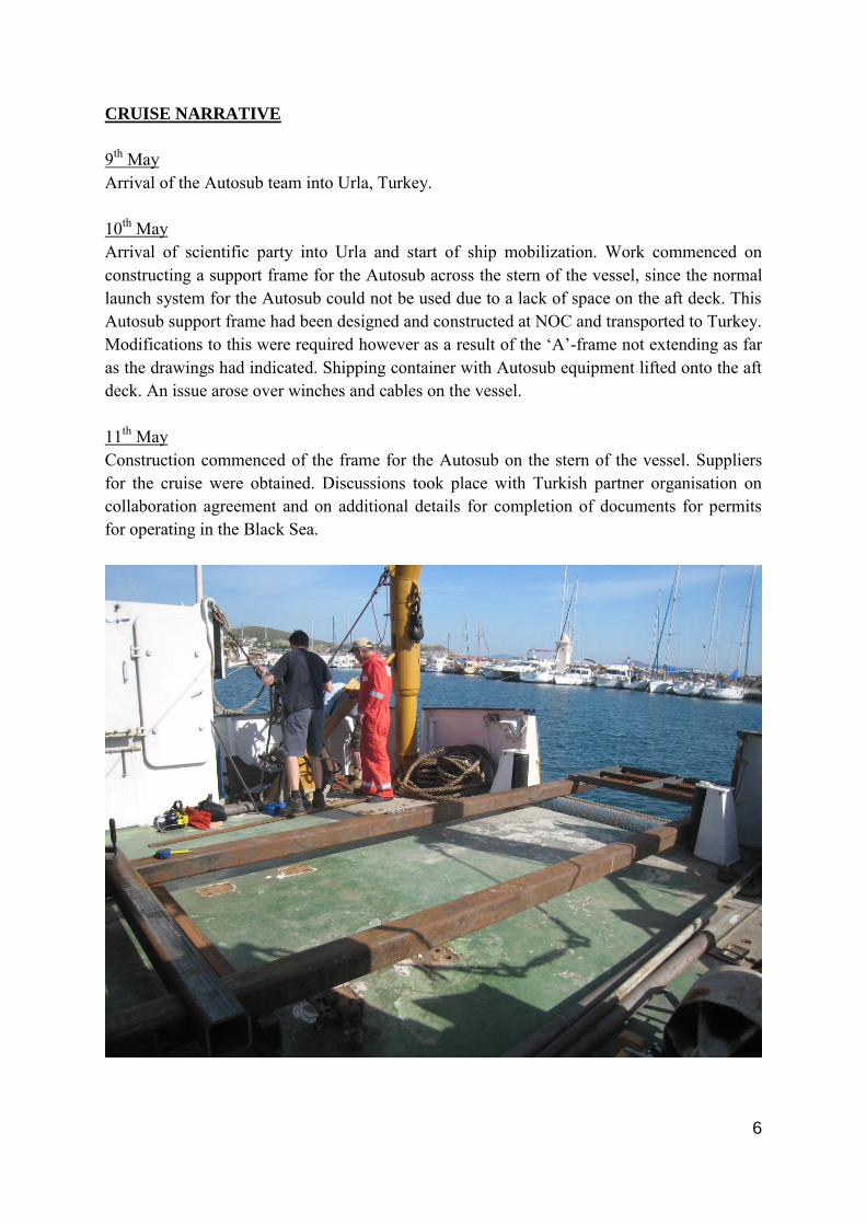
9th May Arrival of the Autosub team into Urla, Turkey. 10th May Arrival of scientific party into Urla and start of ship mobilization. Work commenced on constructing a support frame for the Autosub across the stern of the vessel, since the normal launch system for the Autosub could not be used due to a lack of space on the aft deck. This Autosub support frame had been designed and constructed at NOC and transported to Turkey. Modifications to this were required however as a result of the ‘A’-frame not extending as far as the drawings had indicated. Shipping container with Autosub equipment lifted onto the aft deck. An issue arose over winches and cables on the vessel. 11th May Construction commenced of the frame for the Autosub on the stern of the vessel. Suppliers for the cruise were obtained. Discussions took place with Turkish partner organisation on collaboration agreement and on additional details for completion of documents for permits for operating in the Black Sea.

7
12th May The Autosub frame was completed after extensive welding, and the Autosub was lifted on to the frame using a shore based crane. Tests were then undertaken with the ‘A’-frame lifting the Autosub into and out of the water. These tests were all successful. Acquisition of cruise suppliers was completed and materials loaded on board. Discussions continued on the issue of the winches and the requirement to switch cables.
13th May Sailing delayed whilst winding wire off ship’s winches, and due to a problem extracting air freight from customs. 14th May Scientific party boarded the vessel, final preparations were made, and the ship departed in the early evening. 15th May A day spent in transit from Urla, travelling up the west coast of Turkey, through the Dardanelles and into the Marmara Sea. The forecast was for extremely bad weather and therefore the ship came into port at Saraylar, on the northern side of Marmara Island. During the transit, work continued on setting up of computer systems, other electronics, and

8
discussions on the detailed nature of surveys. Testing of communications systems and internet access was also undertaken. 16th May Poor weather restricted us to staying at Saraylar, and so a series of Autosub tests were conducted in the harbour. Discussions continued with Autosub team on the proposed deployment of Autosub in the Black Sea, including discussion of surveys and the optimal points for starting and finishing these surveys.
17th May Vessel was delayed in port whilst waiting for improved weather. Departed Marmara Island early evening. 18th May Traversed through the Bosphorus Strait and into the field area between the main shipping lanes at the northern exit of the Bosphorus. Testing of the CTDs was undertaken and Autosub mission M435 was successfully deployed. 19th May Grab samples were collected from the sea-floor channel and a series of CTD profiles were collected. Autosub continued on mission M435 independently, though the vessel moved to

9
periodically check on the position and timing of the AUV using an acoustic tow fish placed over the side of the vessel. 20th May In the early hours of the morning, CTD profiles were taken, and then the Autosub was recovered. This involved identifying where the submarine has surfaced and then sending out a team in a rigid inflatable dinghy to attach cables to the AUV. The submarine was then pulled in towards the vessel before finally being brought on board. This process proved difficult despite the excellent sea conditions, demonstrating that recovery is restricted to fair weather conditions. The vessel was then anchored until first light before entering the Bosphorus again and transiting to Büyükdere Port, on the western (European) side of the Bosphorus. This is a government owned wharf. The Autosub was then craned off on to the dock. Analysis of the data showed however, that due to a software glitch, data in the correct parts of the water column had not been collected. Stayed in port overnight.
21st May The Autosub batteries (all 6000 of them) were replaced in the morning, the AUV lifted back onto the vessel, and then the vessel transited back to the field area. In the afternoon the Autosub was launched, but the launch failed. The Autosub was then recovered and the vessel transited back to Büyükdere Port. Dan Parsons was dropped off and flew out of Istanbul Airport. The reasons for the AUV’s launch failure were analysed. Stayed in port overnight.
10
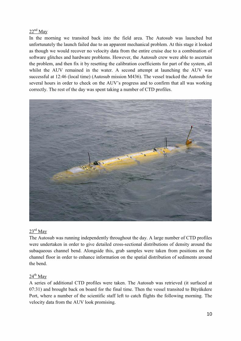
22nd May In the morning we transited back into the field area. The Autosub was launched but unfortunately the launch failed due to an apparent mechanical problem. At this stage it looked as though we would recover no velocity data from the entire cruise due to a combination of software glitches and hardware problems. However, the Autosub crew were able to ascertain the problem, and then fix it by resetting the calibration coefficients for part of the system, all whilst the AUV remained in the water. A second attempt at launching the AUV was successful at 12:46 (local time) (Autosub mission M436). The vessel tracked the Autosub for several hours in order to check on the AUV’s progress and to confirm that all was working correctly. The rest of the day was spent taking a number of CTD profiles.
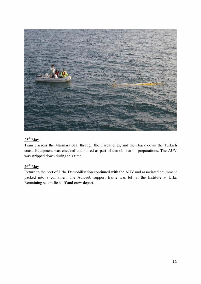
23rd May The Autosub was running independently throughout the day. A large number of CTD profiles were undertaken in order to give detailed cross-sectional distributions of density around the subaqueous channel bend. Alongside this, grab samples were taken from positions on the channel floor in order to enhance information on the spatial distribution of sediments around the bend. 24th May A series of additional CTD profiles were taken. The Autosub was retrieved (it surfaced at 07:31) and brought back on board for the final time. Then the vessel transited to Büyükdere Port, where a number of the scientific staff left to catch flights the following morning. The velocity data from the AUV look promising.
11
25th May Transit across the Marmara Sea, through the Dardanelles, and then back down the Turkish coast. Equipment was checked and stored as part of demobilisation preparations. The AUV was stripped down during this time. 26th May Return to the port of Urla. Demobilisation continued with the AUV and associated equipment packed into a container. The Autosub support frame was left at the Institute at Urla. Remaining scientific staff and crew depart.

12
SUMMARY OF DATA
36 hours of velocity data were collected from the final deployment of the Autosub. Later analysis revealed that only parts of this dataset are of a high quality. None-the-less the dataset represents the first time that anyone has successfully collected three-dimensional velocity data from a gravity current in a subaqueous bend. The high quality data will enable a number of high profile papers to be written, as well as providing key calibration data for numeric simulations of this system. Alongside the velocity data, a large number of CTD profiles were taken, both along the channel system but also in a series of cross-sections around the bend. The correlation between density and velocity cross-sections will enable all the forcing terms to be investigated for a submarine channel bend, therefore greatly increasing knowledge of the fundamental underlying processes within these systems. A large number of grab samples were also collected. These proved to be far more complex than originally thought, revealing a rich array of biology on the seafloor, including mussel beds and abundant tube worms. Areas of clean sediment were also found. Coring was not possible within the time frame, given delays elsewhere in the programme, and due to the fact that the coring could not be undertaken independently whilst the Autosub was onboard. Scientific enquiries about any of these datasets should be directed to the Principal Scientist. Finally, marine wildlife observations were recorded throughout the cruise. Scientific enquiries about these data should be directed towards Dr R. Wynn.
13
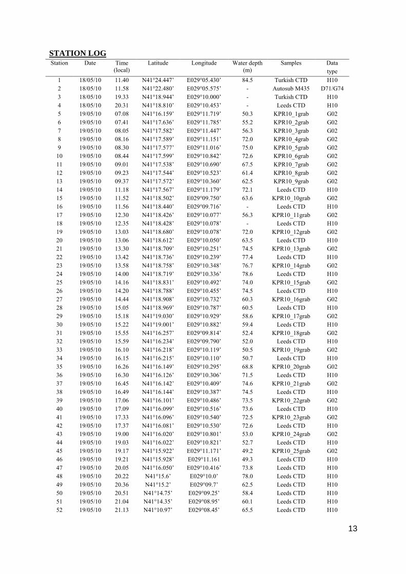
STATION LOG Station Date Time
(local) Latitude Longitude Water depth
(m) Samples Data
type 1 2
18/05/10 18/05/10
11.40 11.58
N41°24.447’ N41°22.480’
E029°05.430’ E029°05.575’
84.5 -
Turkish CTD Autosub M435
H10 D71/G74
3 18/05/10 19.33 N41°18.944’ E029°10.000’ - Turkish CTD H10 4 18/05/10 20.31 N41°18.810’ E029°10.453’ - Leeds CTD H10 5 19/05/10 07.08 N41°16.159’ E029°11.719’ 50.3 KPR10_1grab G02 6 19/05/10 07.41 N41°17.636’ E029°11.785’ 55.2 KPR10_2grab G02 7 19/05/10 08.05 N41°17.582’ E029°11.447’ 56.3 KPR10_3grab G02 8 19/05/10 08.16 N41°17.589’ E029°11.151’ 72.0 KPR10_4grab G02 9 19/05/10 08.30 N41°17.577’ E029°11.016’ 75.0 KPR10_5grab G02
10 19/05/10 08.44 N41°17.599’ E029°10.842’ 72.6 KPR10_6grab G02 11 19/05/10 09.01 N41°17.538’ E029°10.690’ 67.5 KPR10_7grab G02 12 19/05/10 09.23 N41°17.544’ E029°10.523’ 61.4 KPR10_8grab G02 13 19/05/10 09.37 N41°17.572’ E029°10.360’ 62.5 KPR10_9grab G02 14 19/05/10 11.18 N41°17.567’ E029°11.179’ 72.1 Leeds CTD H10 15 16
19/05/10 19/05/10
11.52 11.56
N41°18.502’ N41°18.440’
E029°09.750’ E029°09.716’
63.6 -
KPR10_10grab Leeds CTD
G02 H10
17 18
19/05/10 19/05/10
12.30 12.35
N41°18.426’ N41°18.428’
E029°10.077’ E029°10.078’
56.3 -
KPR10_11grab Leeds CTD
G02 H10
19 20
19/05/10 19/05/10
13.03 13.06
N41°18.680’ N41°18.612’
E029°10.078’ E029°10.050’
72.0 63.5
KPR10_12grab Leeds CTD
G02 H10
21 22
19/05/10 19/05/10
13.30 13.42
N41°18.709’ N41°18.736’
E029°10.251’ E029°10.239’
74.5 77.4
KPR10_13grab Leeds CTD
G02 H10
23 24
19/05/10 19/05/10
13.58 14.00
N41°18.758’ N41°18.719’
E029°10.348’ E029°10.336’
76.7 78.6
KPR10_14grab Leeds CTD
G02 H10
25 26
19/05/10 19/05/10
14.16 14.20
N41°18.831’ N41°18.788’
E029°10.492’ E029°10.455’
74.0 74.5
KPR10_15grab Leeds CTD
G02 H10
27 28
19/05/10 19/05/10
14.44 15.05
N41°18.908’ N41°18.969’
E029°10.732’ E029°10.787’
60.3 60.5
KPR10_16grab Leeds CTD
G02 H10
29 30
19/05/10 19/05/10
15.18 15.22
N41°19.030’ N41°19.001’
E029°10.929’ E029°10.882’
58.6 59.4
KPR10_17grab Leeds CTD
G02 H10
31 32
19/05/10 19/05/10
15.55 15.59
N41°16.257’ N41°16.234’
E029°09.814’ E029°09.790’
52.4 52.0
KPR10_18grab Leeds CTD
G02 H10
33 34
19/05/10 19/05/10
16.10 16.15
N41°16.218’ N41°16.215’
E029°10.119’ E029°10.110’
50.5 50.7
KPR10_19grab Leeds CTD
G02 H10
35 36
19/05/10 19/05/10
16.26 16.30
N41°16.149’ N41°16.126’
E029°10.295’ E029°10.306’
68.8 71.5
KPR10_20grab Leeds CTD
G02 H10
37 38
19/05/10 19/05/10
16.45 16.49
N41°16.142’ N41°16.144’
E029°10.409’ E029°10.387’
74.6 74.5
KPR10_21grab Leeds CTD
G02 H10
39 40
19/05/10 19/05/10
17.06 17.09
N41°16.101’ N41°16.099’
E029°10.486’ E029°10.516’
73.5 73.6
KPR10_22grab Leeds CTD
G02 H10
41 42
19/05/10 19/05/10
17.33 17.37
N41°16.096’ N41°16.081’
E029°10.540’ E029°10.530’
72.5 72.6
KPR10_23grab Leeds CTD
G02 H10
43 44
19/05/10 19/05/10
19.00 19.03
N41°16.020’ N41°16.022’
E029°10.801’ E029°10.821’
53.0 52.7
KPR10_24grab Leeds CTD
G02 H10
45 46
19/05/10 19/05/10
19.17 19.21
N41°15.922’ N41°15.928’
E029°11.171’ E029°11.161
49.2 49.3
KPR10_25grab Leeds CTD
G02 H10
47 19/05/10 20.05 N41°16.050’ E029°10.416’ 73.8 Leeds CTD H10 48 19/05/10 20.22 N41°15.6’ E029°10.0’ 78.0 Leeds CTD H10 49 19/05/10 20.36 N41°15.2’ E029°09.7’ 62.5 Leeds CTD H10 50 19/05/10 20.51 N41°14.75’ E029°09.25’ 58.4 Leeds CTD H10 51 19/05/10 21.04 N41°14.35’ E029°08.95’ 60.1 Leeds CTD H10 52 19/05/10 21.13 N41°10.97’ E029°08.45’ 65.5 Leeds CTD H10
14
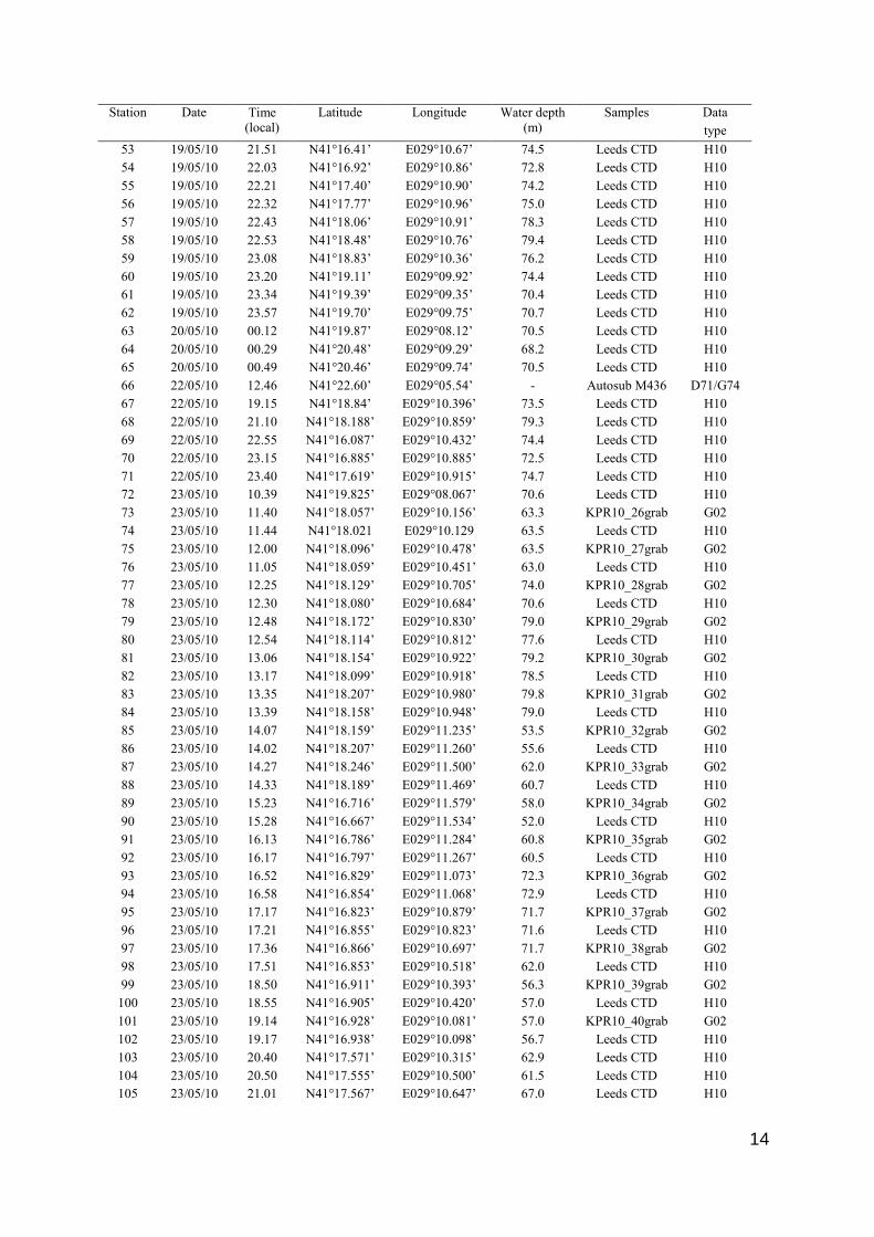
Station Date Time (local)
Latitude Longitude Water depth (m)
Samples Data type
53 19/05/10 21.51 N41°16.41’ E029°10.67’ 74.5 Leeds CTD H10 54 19/05/10 22.03 N41°16.92’ E029°10.86’ 72.8 Leeds CTD H10 55 19/05/10 22.21 N41°17.40’ E029°10.90’ 74.2 Leeds CTD H10 56 19/05/10 22.32 N41°17.77’ E029°10.96’ 75.0 Leeds CTD H10 57 19/05/10 22.43 N41°18.06’ E029°10.91’ 78.3 Leeds CTD H10 58 19/05/10 22.53 N41°18.48’ E029°10.76’ 79.4 Leeds CTD H10 59 19/05/10 23.08 N41°18.83’ E029°10.36’ 76.2 Leeds CTD H10 60 19/05/10 23.20 N41°19.11’ E029°09.92’ 74.4 Leeds CTD H10 61 19/05/10 23.34 N41°19.39’ E029°09.35’ 70.4 Leeds CTD H10 62 19/05/10 23.57 N41°19.70’ E029°09.75’ 70.7 Leeds CTD H10 63 20/05/10 00.12 N41°19.87’ E029°08.12’ 70.5 Leeds CTD H10 64 20/05/10 00.29 N41°20.48’ E029°09.29’ 68.2 Leeds CTD H10 65 20/05/10 00.49 N41°20.46’ E029°09.74’ 70.5 Leeds CTD H10 66 22/05/10 12.46 N41°22.60’ E029°05.54’ - Autosub M436 D71/G74 67 22/05/10 19.15 N41°18.84’ E029°10.396’ 73.5 Leeds CTD H10 68 22/05/10 21.10 N41°18.188’ E029°10.859’ 79.3 Leeds CTD H10 69 22/05/10 22.55 N41°16.087’ E029°10.432’ 74.4 Leeds CTD H10 70 22/05/10 23.15 N41°16.885’ E029°10.885’ 72.5 Leeds CTD H10 71 22/05/10 23.40 N41°17.619’ E029°10.915’ 74.7 Leeds CTD H10 72 23/05/10 10.39 N41°19.825’ E029°08.067’ 70.6 Leeds CTD H10 73 74
23/05/10 23/05/10
11.40 11.44
N41°18.057’ N41°18.021
E029°10.156’ E029°10.129
63.3 63.5
KPR10_26grab Leeds CTD
G02 H10
75 76
23/05/10 23/05/10
12.00 11.05
N41°18.096’ N41°18.059’
E029°10.478’ E029°10.451’
63.5 63.0
KPR10_27grab Leeds CTD
G02 H10
77 78
23/05/10 23/05/10
12.25 12.30
N41°18.129’ N41°18.080’
E029°10.705’ E029°10.684’
74.0 70.6
KPR10_28grab Leeds CTD
G02 H10
79 80
23/05/10 23/05/10
12.48 12.54
N41°18.172’ N41°18.114’
E029°10.830’ E029°10.812’
79.0 77.6
KPR10_29grab Leeds CTD
G02 H10
81 82
23/05/10 23/05/10
13.06 13.17
N41°18.154’ N41°18.099’
E029°10.922’ E029°10.918’
79.2 78.5
KPR10_30grab Leeds CTD
G02 H10
83 84
23/05/10 23/05/10
13.35 13.39
N41°18.207’ N41°18.158’
E029°10.980’ E029°10.948’
79.8 79.0
KPR10_31grab Leeds CTD
G02 H10
85 86
23/05/10 23/05/10
14.07 14.02
N41°18.159’ N41°18.207’
E029°11.235’ E029°11.260’
53.5 55.6
KPR10_32grab Leeds CTD
G02 H10
87 88
23/05/10 23/05/10
14.27 14.33
N41°18.246’ N41°18.189’
E029°11.500’ E029°11.469’
62.0 60.7
KPR10_33grab Leeds CTD
G02 H10
89 90
23/05/10 23/05/10
15.23 15.28
N41°16.716’ N41°16.667’
E029°11.579’ E029°11.534’
58.0 52.0
KPR10_34grab Leeds CTD
G02 H10
91 92
23/05/10 23/05/10
16.13 16.17
N41°16.786’ N41°16.797’
E029°11.284’ E029°11.267’
60.8 60.5
KPR10_35grab Leeds CTD
G02 H10
93 94
23/05/10 23/05/10
16.52 16.58
N41°16.829’ N41°16.854’
E029°11.073’ E029°11.068’
72.3 72.9
KPR10_36grab Leeds CTD
G02 H10
95 96
23/05/10 23/05/10
17.17 17.21
N41°16.823’ N41°16.855’
E029°10.879’ E029°10.823’
71.7 71.6
KPR10_37grab Leeds CTD
G02 H10
97 98
23/05/10 23/05/10
17.36 17.51
N41°16.866’ N41°16.853’
E029°10.697’ E029°10.518’
71.7 62.0
KPR10_38grab Leeds CTD
G02 H10
99 100
23/05/10 23/05/10
18.50 18.55
N41°16.911’ N41°16.905’
E029°10.393’ E029°10.420’
56.3 57.0
KPR10_39grab Leeds CTD
G02 H10
101 102
23/05/10 23/05/10
19.14 19.17
N41°16.928’ N41°16.938’
E029°10.081’ E029°10.098’
57.0 56.7
KPR10_40grab Leeds CTD
G02 H10
103 23/05/10 20.40 N41°17.571’ E029°10.315’ 62.9 Leeds CTD H10 104 23/05/10 20.50 N41°17.555’ E029°10.500’ 61.5 Leeds CTD H10 105 23/05/10 21.01 N41°17.567’ E029°10.647’ 67.0 Leeds CTD H10

15
Station Date Time (local)
Latitude Longitude Water depth (m)
Samples Data type
106 23/05/10 21.14 N41°17.578’ E029°10.789’ 72.8 Leeds CTD H10 107 23/05/10 21.23 N41°17.572’ E029°10.884’ 75.0 Leeds CTD H10 108 23/05/10 22.44 N41°17.601’ E029°11.097’ 72.4 Leeds CTD H10 109 23/05/10 22.59 N41°17.592’ E029°11.395’ 56.5 Leeds CTD H10 110 23/05/10 23.11 N41°17.599’ E029°11.744’ 56.3 Leeds CTD H10 111 24/05/10 05.13 N41°30.998’ E029°00.521’ 97.5 Leeds CTD H10 112 24/05/10 05.27 N41°30.844’ E029°01.077’ 94.0 Leeds CTD H10 113 24/05/10 05.37 N41°30.755’ E029°01.395’ 98.0 Leeds CTD H10 114 24/05/10 05.49 N41°30.705’ E029°01.633’ 98.0 Leeds CTD H10 115 24/05/10 06.10 N41°30.178’ E029°03.607’ 97.4 Leeds CTD H10 116 24/0/5/10 06.24 N41°30.142’ E029°03.829’ 94.2 Leeds CTD H10 117 24/05/10 06.55 N41°28.827’ E029°01.731’ 91.9 Leeds CTD H10 118 24/05/10 07.09 N41°28.741’ E029°01.101’ 92.0 Leeds CTD H10 119 24/05/10 08.00 N41°27.114’ E029°01.463’ 90.0 Leeds CTD H10 120 24/05/10 08.13 N41°26.887’ E029°01.196’ 84.7 Leeds CTD H10 121 24/05/10 08.37 N41°25.046’ E029°02.648’ 85.0 Leeds CTD H10 122 24/05/10 08.58 N41°23.726’ E029°03.395’ 80.6 Leeds CTD H10 123 24/05/10 09.20 N41°21.894’ E029°02.966’ 80.7 Leeds CTD H10 124 24/05/10 09.39 N41°22.541’ E029°04.248’ 80.5 Leeds CTD H10 125 24/05/10 09.50 N41°21.864’ E029°04.569’ 80.6 Leeds CTD H10 126 24/05/10 11.30 N41°21.400’ E029°05.118’ 81.3 Leeds CTD H10 127 24/05/10 11.49 N41°20.716’ E029°06.550’ 78.0 Leeds CTD H10 128 24/05/10 12.06 N41°19.878’ E029°07.907’ 75.3 Leeds CTD H10 129 24/05/10 12.32 N41°20.869’ E029°09.682’ 76.0 Leeds CTD H10 130 24/05/10 13.00 N41°22.390’ E029°10.116’ 79.6 Leeds CTD H10 131 24/05/10 14.03 N41°15.505’ E029°09.822’ 73.0 Leeds CTD H10 132 24/05/10 14.21 N41°14.750’ E029°09.163’ 60.2 Leeds CTD H10

16
TRACK CHARTS