Cretaceous Reservoirs Assessment Unit 20300101 - USGS · 2026 2025 2034 2023 2024 2029 1112 2030...
11
# # ## # # # ## # # ## ## ## ## # ## # ## # ## # ## ## # # # # # ### # ## # # ## # ## # # # # ## # ### # # ### # ## # # ### ## # # # # # # # # # # # # # # # # # # # # # # # # # # # # # # # # # # # # # # # # # # # # # # ## # # # # ## # # # # # # # # # # # # # # ## # # # # # # # # ## # # ## # # # # # ## # ## # # # # # ## # ## # # # # # # # ## # ## # ### # # ## # # # # # ## # ## # # # # Ê Ú Ê Ú Ê Ú Ê Ú Ê Ú Ê Ú Ê Ú Ê Ú Ê Ú Ê Ú Ê Ú Ê Ú Ê Ú Ê Ú Ê Ú Ê Ú Ê Ú 2024 2023 2075 Kuwait 0 250 500 KILOMETERS Tabriz Tehran Esfahan Mosul Baghdad Shiraz Al Basra Al Kuwayt Ar Riyad Dhahran Abu Zaby Doha Caspian Sea Arabian/ Persian Gulf U.A.E. Qatar Iran Iraq Saudi Arabia 25 30 35 40 55 50 45 40 Cretaceous Reservoirs Assessment Unit 20300101 Other geologic province boundary Zagros Fold Belt Geologic Province 2030 Cretaceous Reservoirs Assessment Unit 20300101 Erzurum
Transcript of Cretaceous Reservoirs Assessment Unit 20300101 - USGS · 2026 2025 2034 2023 2024 2029 1112 2030...

############# ##### ############# #### ########### ### ######## ##### ### #####
########## #### #### #### ### # # ###
####### # #
# ### ## ### ##
##### ## ### ### ### #### ### #### # ####
# ### ### # ##### ### ### ### # ### # ## # #### ### ### ## ### ## # ## # ## # # ###### ### ###
#### ##
###
#
ÊÚÊÚÊÚ
ÊÚ ÊÚ
ÊÚ ÊÚ
ÊÚ
ÊÚ
ÊÚ
ÊÚ
ÊÚÊÚ
ÊÚ
ÊÚ
ÊÚÊÚ
2024
2023
2075
Kuwait
0 250 500 KILOMETERS
Tabriz
Tehran
Esfahan
Mosul
Baghdad
Shiraz
Al Basra
Al Kuwayt
Ar Riyad
Dhahran
Abu Zaby
Doha
CaspianSea
Arabian/Persian
Gulf
U.A.E.
Qatar
Iran
Iraq
SaudiArabia
25
30
35
40
55504540
Cretaceous ReservoirsAssessment Unit 20300101
Other geologic province boundary
Zagros Fold Belt Geologic Province 2030
Cretaceous Reservoirs Assessment Unit 20300101
Erzurum

Page 1
USGS PROVINCE: Zagros Fold Belt (2030) GEOLOGIST: T.S. Ahlbrandt TOTAL PETROLEUM SYSTEM: Zagros-Mesopotamian Cretaceous-Tertiary (203001) ASSESSMENT UNIT: Cretaceous Reservoirs (20300101) DESCRIPTION: This assessment unit contains both Cretaceous carbonate and clastic reservoirs in the Zagros fold belt and foreland. Clastic reservoirs predominate on the western side of the assessment unit whereas carbonate reservoirs are more common to the east nearer the Zagros thrust belt. The Total Petroleum System was considered to be charged by Cretaceous source rocks although there is uncertainty about mixing of Jurassic and Cretaceous oils in the area. Considerable proprietary data was available, particularly in Iran and Iraq, that facilitated the analysis including GeoMark data and other sources. Structural complexity increases in the unit in the direction of the Zagros Mountains. SOURCE ROCKS: Several source rock intervals have been identified dominated by Lower Cretaceous Shales. The Berriasian Sulaiy and Minagish Formations are known source intervals in Kuwait. Source rocks have been identified in several Cretaceous age intervals including Hauterivian Ratawi Shale, Albian Zubair, Aptian Burgan (Nahr Umr), Shuaiba, and Mauddud Formations. Upper Cretaceous source rocks include Cenomanian Rumaila and Mishrif Formations. MATURATION: Maturation (expulsion) in some models commences as early as 90 Ma with peak expulsion about 27 Ma. Most models show peak generation to be very recent (15 Ma or less) in the Mid Miocene (Neogene) coincident with the Zagros collision and the thick accumulation of orogenic clastics in the Zagros foredeep. MIGRATION: Although expulsion may have started in Late Cretaceous, significant migration commenced probably no earlier than latest Oligocene/earliest Miocene and continues to present. Migration into the Zagros fold and thrust belt has permitted extensive oil and gas seeps and tar belt formation in the eastern Zagros thrust. The eternal flame at Kirkuk is an example of the ongoing charge and seepage of petroleum on the east flank of the petroleum system. RESERVOIR ROCKS: The dominant clastic reservoirs, principally the Zubair (Barremian) and Burgan (Aptian) Sandstone are related to clastic, dominantly deltaic, sediment influx from western source areas such as the Saudi Arabian shield or to the north the Rutbah or Mardin high. Rudistid carbonate reservoirs are common in both Lower Cretaceous carbonate reservoirs such as Shuaiba Formation (Aptian) as well as Upper Cretaceous carbonate reservoirs such as Mishrif Formation (Cenomanian). A variety of other reservoirs related to oolites, and fracturing are known to occur in Cretaceous rocks. TRAPS AND SEALS: There are several regional unconformities and shales that form significant seals. The Nahr Umr Shale (Aptian) is a major regional shale seal trapping major accumulations at Burgan, Safaniya, Rumaila, Zubair, Majnoon, and East Baghdad, as well as at many other localities. A Miocene salt seal in the Zagros fold belt is a critical block to vertical migration in the thrust belt structures of Iraq and Iran.

Page 2
REFERENCES: Abdullah, F.H.A., Nederlof, P.J.R., Ormerod, M.P., and Kinghorn, R.R.F., 1997, Thermal
history of the Lower and Middle Cretaceous source rocks in Kuwait: GeoArabia, v. 2, no. 2, p. 151-164.
Alsharhan, A.S., and Nairn, A.E.M., 1997, Sedimentary basins and petroleum geology of the Middle East: Netherlands, Elsevier, 843 p.
Christian, L., 1997, Cretaceous subsurface geology of the Middle East region: GeoArabia, v. 2, no. 3, p. 239-256.

20300101
20300101Assessment unitcode and boundary
1155
2031
20942075
2091
2074
2089
2092
2028
2026
2025
2034
2023
2024
2029
1112
2030
2030
Assessment Unit - 20300101Cretaceous Reservoirs
EXPLANATION
HydrographyShorelineGeologic province code and boundaryCountry boundaryGas field centerpointOil field centerpoint
Projection: Robinson. Central meridian: 0
180 KILOMETERS
40 42 44 46 48 50 52 54 56 58 60
26
28
30
32
34
36
38
Iran
Iraq
Syria
Kuwait
BahrainQatar
Tabriz Ashkhabad
Mosul Mashhad
Tehran
BaghdadEsfahan
Al Basra
ShirazAl Kuwayt
Dhahran
Doha
TurkeyCaspian Sea
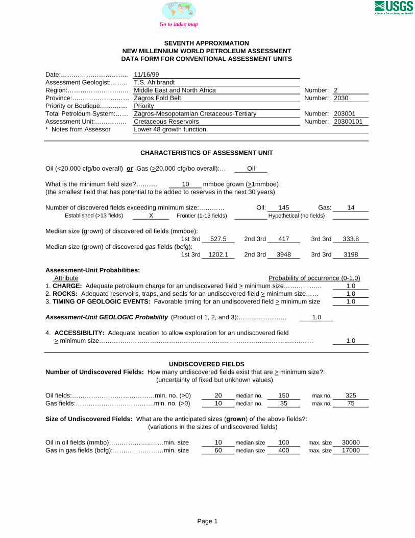
SEVENTH APPROXIMATIONNEW MILLENNIUM WORLD PETROLEUM ASSESSMENTDATA FORM FOR CONVENTIONAL ASSESSMENT UNITS
Date:………………………….. 11/16/99Assessment Geologist:…….. T.S. AhlbrandtRegion:……………………….. Middle East and North Africa Number: 2Province:……………………… Zagros Fold Belt Number: 2030Priority or Boutique.………… PriorityTotal Petroleum System:…… Zagros-Mesopotamian Cretaceous-Tertiary Number: 203001Assessment Unit:…………… Cretaceous Reservoirs Number: 20300101* Notes from Assessor Lower 48 growth function.
CHARACTERISTICS OF ASSESSMENT UNIT
Oil (<20,000 cfg/bo overall) or Gas (>20,000 cfg/bo overall):… Oil
What is the minimum field size?………. 10 mmboe grown (>1mmboe)(the smallest field that has potential to be added to reserves in the next 30 years)
Number of discovered fields exceeding minimum size:………… Oil: 145 Gas: 14 Established (>13 fields) X Frontier (1-13 fields) Hypothetical (no fields)
Median size (grown) of discovered oil fields (mmboe):1st 3rd 527.5 2nd 3rd 417 3rd 3rd 333.8
Median size (grown) of discovered gas fields (bcfg):1st 3rd 1202.1 2nd 3rd 3948 3rd 3rd 3198
Assessment-Unit Probabilities: Attribute Probability of occurrence (0-1.0)1. CHARGE: Adequate petroleum charge for an undiscovered field > minimum size……………… 1.02. ROCKS: Adequate reservoirs, traps, and seals for an undiscovered field > minimum size…… 1.03. TIMING OF GEOLOGIC EVENTS: Favorable timing for an undiscovered field > minimum size 1.0
Assessment-Unit GEOLOGIC Probability (Product of 1, 2, and 3):……...…….....…. 1.0
4. ACCESSIBILITY: Adequate location to allow exploration for an undiscovered field > minimum size……………………………………………………..………………..……..………… 1.0
UNDISCOVERED FIELDSNumber of Undiscovered Fields: How many undiscovered fields exist that are > minimum size?:
(uncertainty of fixed but unknown values)
Oil fields:…………………………………min. no. (>0) 20 median no. 150 max no. 325Gas fields:……………………………….min. no. (>0) 10 median no. 35 max no. 75
Size of Undiscovered Fields: What are the anticipated sizes (grown) of the above fields?: (variations in the sizes of undiscovered fields)
Oil in oil fields (mmbo)………………..……min. size 10 median size 100 max. size 30000Gas in gas fields (bcfg):……………………min. size 60 median size 400 max. size 17000
Page 1
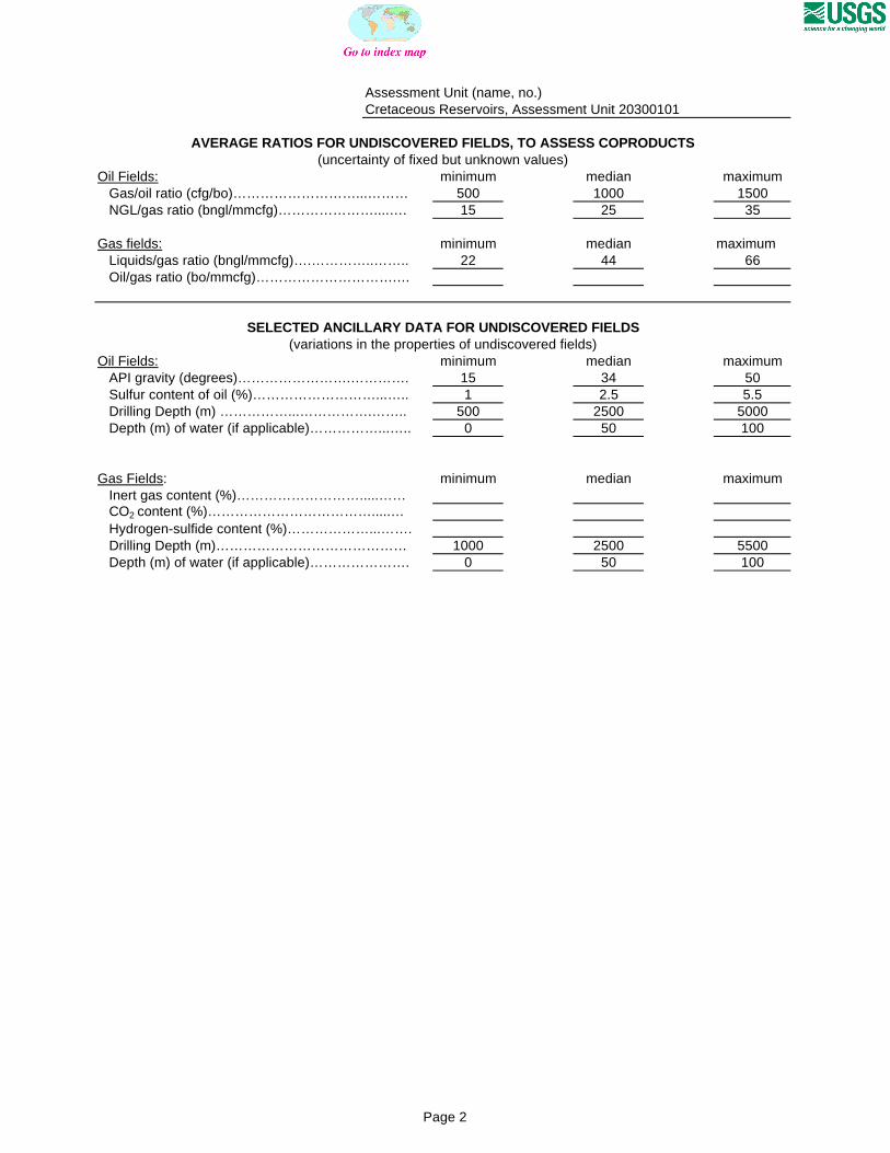
Assessment Unit (name, no.)Cretaceous Reservoirs, Assessment Unit 20300101
AVERAGE RATIOS FOR UNDISCOVERED FIELDS, TO ASSESS COPRODUCTS(uncertainty of fixed but unknown values)
Oil Fields: minimum median maximum Gas/oil ratio (cfg/bo)………………………...……… 500 1000 1500 NGL/gas ratio (bngl/mmcfg)…………………....…. 15 25 35
Gas fields: minimum median maximum Liquids/gas ratio (bngl/mmcfg)….…………..…….. 22 44 66 Oil/gas ratio (bo/mmcfg)………………………….…
SELECTED ANCILLARY DATA FOR UNDISCOVERED FIELDS(variations in the properties of undiscovered fields)
Oil Fields: minimum median maximum API gravity (degrees)…………………….…………. 15 34 50 Sulfur content of oil (%)………………………...….. 1 2.5 5.5 Drilling Depth (m) ……………...…………….…….. 500 2500 5000 Depth (m) of water (if applicable)……………...….. 0 50 100
Gas Fields: minimum median maximum Inert gas content (%)……………………….....…… CO2 content (%)……………………………….....… Hydrogen-sulfide content (%)………………...……. Drilling Depth (m)…………………………………… 1000 2500 5500 Depth (m) of water (if applicable)…………………. 0 50 100
Page 2

Assessment Unit (name, no.)Cretaceous Reservoirs, Assessment Unit 20300101
ALLOCATION OF UNDISCOVERED RESOURCES IN THE ASSESSMENT UNITTO COUNTRIES OR OTHER LAND PARCELS (uncertainty of fixed but unknown values)
1. Iraq represents 37.1 areal % of the total assessment unit
Oil in Oil Fields: minimum median maximum Richness factor (unitless multiplier):……….…..… Volume % in parcel (areal % x richness factor):… 45 Portion of volume % that is offshore (0-100%)…… 0
Gas in Gas Fields: minimum median maximum Richness factor (unitless multiplier):…………..…. Volume % in parcel (areal % x richness factor):… 29 Portion of volume % that is offshore (0-100%)…… 0
2. Iran represents 47.7 areal % of the total assessment unit
Oil in Oil Fields: minimum median maximum Richness factor (unitless multiplier):……….…..… Volume % in parcel (areal % x richness factor):… 42 Portion of volume % that is offshore (0-100%)…… 20
Gas in Gas Fields: minimum median maximum Richness factor (unitless multiplier):…………..…. Volume % in parcel (areal % x richness factor):… 60 Portion of volume % that is offshore (0-100%)…… 20
3. Kuwait represents 4.3 areal % of the total assessment unit
Oil in Oil Fields: minimum median maximum Richness factor (unitless multiplier):……….…..… Volume % in parcel (areal % x richness factor):… 5 Portion of volume % that is offshore (0-100%)…… 60
Gas in Gas Fields: minimum median maximum Richness factor (unitless multiplier):…………..…. Volume % in parcel (areal % x richness factor):… 5 Portion of volume % that is offshore (0-100%)…… 60
4. Saudi Arabia represents 5.1 areal % of the total assessment unit
Oil in Oil Fields: minimum median maximum Richness factor (unitless multiplier):……….…..… Volume % in parcel (areal % x richness factor):… 5 Portion of volume % that is offshore (0-100%)…… 70
Gas in Gas Fields: minimum median maximum Richness factor (unitless multiplier):…………..…. Volume % in parcel (areal % x richness factor):… 5 Portion of volume % that is offshore (0-100%)…… 70
Page 3

5. Turkey represents 3.1 areal % of the total assessment unit
Oil in Oil Fields: minimum median maximum Richness factor (unitless multiplier):……….…..… Volume % in parcel (areal % x richness factor):… 1 Portion of volume % that is offshore (0-100%)…… 0
Gas in Gas Fields: minimum median maximum Richness factor (unitless multiplier):…………..…. Volume % in parcel (areal % x richness factor):… 0 Portion of volume % that is offshore (0-100%)…… 0
6. Bahrain represents 0.6 areal % of the total assessment unit
Oil in Oil Fields: minimum median maximum Richness factor (unitless multiplier):……….…..… Volume % in parcel (areal % x richness factor):… 1 Portion of volume % that is offshore (0-100%)…… 95
Gas in Gas Fields: minimum median maximum Richness factor (unitless multiplier):…………..…. Volume % in parcel (areal % x richness factor):… 1 Portion of volume % that is offshore (0-100%)…… 95
7. Syria represents 2.1 areal % of the total assessment unit
Oil in Oil Fields: minimum median maximum Richness factor (unitless multiplier):……….…..… Volume % in parcel (areal % x richness factor):… 1 Portion of volume % that is offshore (0-100%)…… 0
Gas in Gas Fields: minimum median maximum Richness factor (unitless multiplier):…………..…. Volume % in parcel (areal % x richness factor):… 0 Portion of volume % that is offshore (0-100%)…… 0
8. Province 2030 represents 56.6 areal % of the total assessment unit
Oil in Oil Fields: minimum median maximum Richness factor (unitless multiplier):……….…..… Volume % in parcel (areal % x richness factor):… 35 Portion of volume % that is offshore (0-100%)…… 5
Gas in Gas Fields: minimum median maximum Richness factor (unitless multiplier):…………..…. Volume % in parcel (areal % x richness factor):… 80 Portion of volume % that is offshore (0-100%)…… 3
Page 4

9. Province 2024 represents 35.9 areal % of the total assessment unit
Oil in Oil Fields: minimum median maximum Richness factor (unitless multiplier):……….…..… Volume % in parcel (areal % x richness factor):… 60 Portion of volume % that is offshore (0-100%)…… 20
Gas in Gas Fields: minimum median maximum Richness factor (unitless multiplier):…………..…. Volume % in parcel (areal % x richness factor):… 15 Portion of volume % that is offshore (0-100%)…… 84
10. Province 2023 represents 6.3 areal % of the total assessment unit
Oil in Oil Fields: minimum median maximum Richness factor (unitless multiplier):……….…..… Volume % in parcel (areal % x richness factor):… 2 Portion of volume % that is offshore (0-100%)…… 0
Gas in Gas Fields: minimum median maximum Richness factor (unitless multiplier):…………..…. Volume % in parcel (areal % x richness factor):… 0 Portion of volume % that is offshore (0-100%)…… 0
11. Province 2075 represents 0.6 areal % of the total assessment unit
Oil in Oil Fields: minimum median maximum Richness factor (unitless multiplier):……….…..… Volume % in parcel (areal % x richness factor):… 1 Portion of volume % that is offshore (0-100%)…… 0
Gas in Gas Fields: minimum median maximum Richness factor (unitless multiplier):…………..…. Volume % in parcel (areal % x richness factor):… 0 Portion of volume % that is offshore (0-100%)…… 0
12. Province 2021 represents 0.6 areal % of the total assessment unit
Oil in Oil Fields: minimum median maximum Richness factor (unitless multiplier):……….…..… Volume % in parcel (areal % x richness factor):… 2 Portion of volume % that is offshore (0-100%)…… 95
Gas in Gas Fields: minimum median maximum Richness factor (unitless multiplier):…………..…. Volume % in parcel (areal % x richness factor):… 5 Portion of volume % that is offshore (0-100%)…… 90
Page 5

0
5
10
15
20
25
30
8-<16 16-<32 32-<64 64-<128 128-<256
256-<512
512-<1024
1024-<2048
2048-<4096
4096-<8192
8192-<16384
16384-<32768
OIL-FIELD SIZE (MMBO)
UN
DIS
CO
VE
RE
D O
IL F
IEL
DS
(N
o.)
Minimum field size: 10 MMBO
Mean number ofundiscovered fields: 156.4
Cretaceous Reservoirs, AU 20300101 Undiscovered Field-Size Distribution

0
1
2
3
4
5
6
7
8
9
10
48-<96 96-<192 192-<384 384-<768 768-<1536
1536-<3072
3072-<6144
6144-<12288
12288-<24576
24576-<49152
GAS-FIELD SIZE (BCFG)
UN
DIS
CO
VE
RE
D G
AS
FIE
LD
S (
No
.)
Minimum field size: 60 BCFG
Mean number ofundiscovered fields: 36.9
Cretaceous Reservoirs, AU 20300101 Undiscovered Field-Size Distribution