County of San Diego Housing Element Inventory Bonsall€¦ · County of San Diego . Housing Element...
5
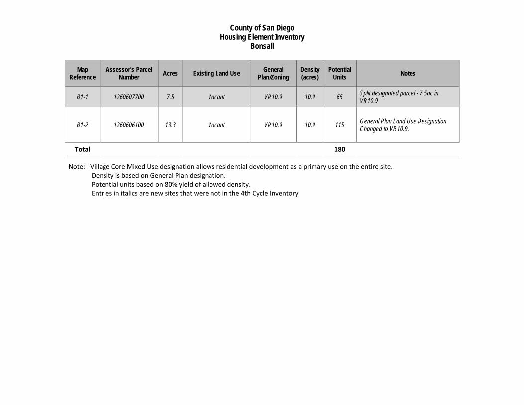
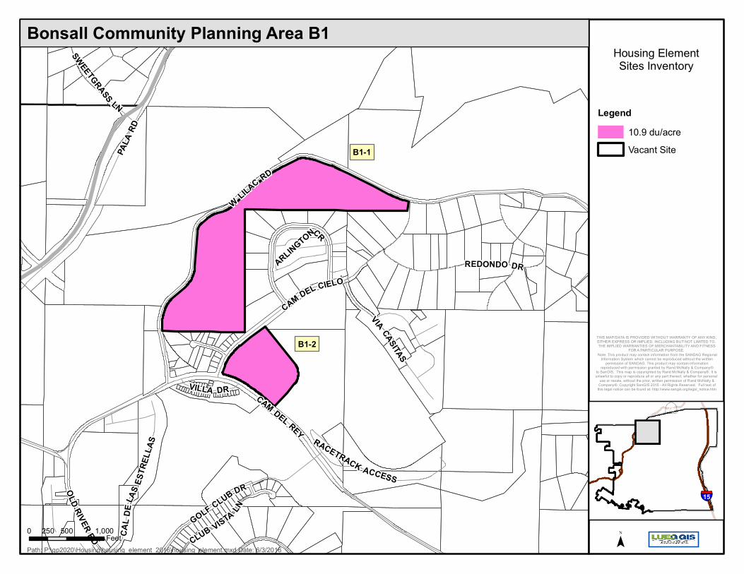
County of San Diego Housing Element Inventory Bonsall Map Reference Assessor's Parcel Number Acres Existing Land Use General Plan/Zoning Density (acres) Potential Units Notes B1-1 1260607700 7.5 Vacant VR10.9 10.9 65 Split designated parcel - 7.5ac in VR10.9 B1-2 1260606100 13.3 Vacant VR10.9 10.9 115 General Plan Land Use Designation Changed to VR10.9. Total 180 Note: Village Core Mixed Use designation allows residential development as a primary use on the entire site. Density is based on General Plan designation. Potential units based on 80% yield of allowed density. Entries in italics are new sites that were not in the 4th Cycle Inventory
Transcript of County of San Diego Housing Element Inventory Bonsall€¦ · County of San Diego . Housing Element...
County of San Diego Housing Element Inventory
Bonsall
Map Reference
Assessor's Parcel Number Acres Existing Land Use General
Plan/Zoning Density (acres)
Potential Units Notes
B1-1 1260607700 7.5 Vacant VR10.9 10.9 65 Split designated parcel - 7.5ac in VR10.9
B1-2 1260606100 13.3 Vacant VR10.9 10.9 115 General Plan Land Use Designation Changed to VR10.9.
Total 180
Note: Village Core Mixed Use designation allows residential development as a primary use on the entire site. Density is based on General Plan designation. Potential units based on 80% yield of allowed density. Entries in italics are new sites that were not in the 4th Cycle Inventory
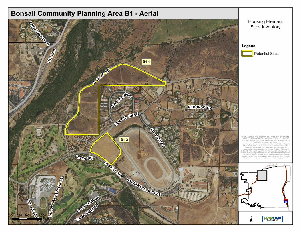
B1-1
B1-2
CAM DEL REY
CAM DEL CIELO
VIA CASITAS
VILLA DR
PALA
RD
GOLF CLUB DR
WLILAC RD
CLUB VISTA LN
ARLINGTONCR
CAL D
ELAS
ESTR
ELLA
S
OLD RIVER RD
REDONDO DR
SWEETGRASS LN
RACETRACK ACCESS
Housing ElementSites Inventory
LegendPotential Sites
Path: P:\gp2020\Housing\housing_element_2016\housing_element.mxd Date: 6/3/2016
Bonsall Community Planning Area B1 - Aerial
0 500 1,000250Feet ¯
∙ÿ
§̈¦
76
15
THIS MAP/DATA IS PROVIDED WITHOUT WARRANTY OF ANY KIND, EITHER EXPRESS OR IMPLIED, INCLUDING BUT NOT LIMITED TO, THE IMPLIED WARRANTIES OF MERCHANTABILITY AND FITNESS
FOR A PARTICULAR PURPOSE. Note: This product may contain information from the SANDAG Regional
Information System which cannot be reproduced without the writtenpermission of SANDAG. This product may contain information
reproduced with permission granted by Rand McNally & Company®to SanGIS. This map is copyrighted by Rand McNally & Company®. It is unlawful to copy or reproduce all or any part thereof, whether for personal
use or resale, without the prior, written permission of Rand McNally &Company®. Copyright SanGIS 2015 - All Rights Reserved. Full text of
this legal notice can be found at: http://www.sangis.org/legal_notice.htm
B1-1
B1-2
CAM DEL REY
CAM DEL CIELO
VIA CASITAS
VILLA DR
PALA
RD
GOLF CLUB DR
WLILAC RD
CLUB VISTA LN
ARLINGTONCR
CAL D
ELAS
ESTR
ELLA
S
OLD RIVER RD
REDONDO DR
SWEETGRASS LN
RACETRACK ACCESS
Housing ElementSites Inventory
Legend10.9 du/acreVacant Site
Path: P:\gp2020\Housing\housing_element_2016\housing_element.mxd Date: 6/3/2016
Bonsall Community Planning Area B1
0 500 1,000250Feet ¯
∙ÿ
§̈¦
76
15
THIS MAP/DATA IS PROVIDED WITHOUT WARRANTY OF ANY KIND, EITHER EXPRESS OR IMPLIED, INCLUDING BUT NOT LIMITED TO, THE IMPLIED WARRANTIES OF MERCHANTABILITY AND FITNESS
FOR A PARTICULAR PURPOSE. Note: This product may contain information from the SANDAG Regional
Information System which cannot be reproduced without the writtenpermission of SANDAG. This product may contain information
reproduced with permission granted by Rand McNally & Company®to SanGIS. This map is copyrighted by Rand McNally & Company®. It is unlawful to copy or reproduce all or any part thereof, whether for personal
use or resale, without the prior, written permission of Rand McNally &Company®. Copyright SanGIS 2015 - All Rights Reserved. Full text of
this legal notice can be found at: http://www.sangis.org/legal_notice.htm
B1-1
B1-2
CAM DEL REY
CAM DEL CIELO
VIA CASITAS
VILLA DR
PALA
RD
GOLF CLUB DR
WLILAC RD
CLUB VISTA LN
ARLINGTONCR
CAL D
ELAS
ESTR
ELLA
S
OLD RIVER RD
REDONDO DR
SWEETGRASS LN
RACETRACK ACCESS
Housing ElementSites Inventory
LegendPotential SitesSlope >25%
FEMA Flood Hazard Zone100 Year Flood Plain500 Year Flood WayWetlands (RPO)
Path: P:\gp2020\Housing\housing_element_2016\housing_element.mxd Date: 6/3/2016
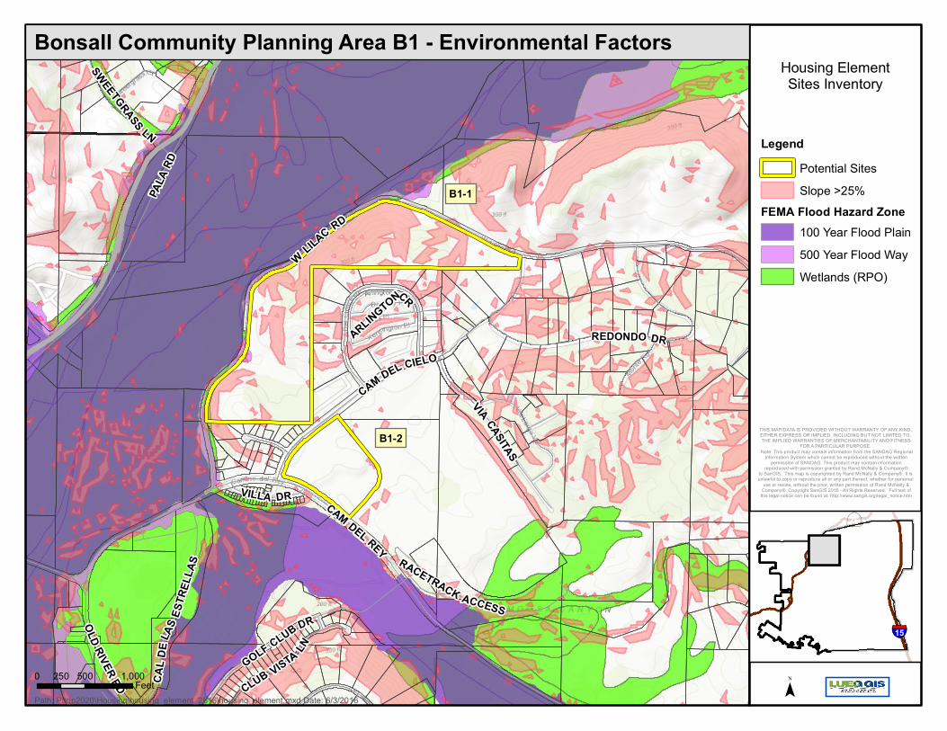
Bonsall Community Planning Area B1 - Environmental Factors
0 500 1,000250Feet ¯
∙ÿ
§̈¦
76
15
THIS MAP/DATA IS PROVIDED WITHOUT WARRANTY OF ANY KIND, EITHER EXPRESS OR IMPLIED, INCLUDING BUT NOT LIMITED TO, THE IMPLIED WARRANTIES OF MERCHANTABILITY AND FITNESS
FOR A PARTICULAR PURPOSE. Note: This product may contain information from the SANDAG Regional
Information System which cannot be reproduced without the writtenpermission of SANDAG. This product may contain information
reproduced with permission granted by Rand McNally & Company®to SanGIS. This map is copyrighted by Rand McNally & Company®. It is unlawful to copy or reproduce all or any part thereof, whether for personal
use or resale, without the prior, written permission of Rand McNally &Company®. Copyright SanGIS 2015 - All Rights Reserved. Full text of
this legal notice can be found at: http://www.sangis.org/legal_notice.htm
B1-1
B1-2
CAM DEL REY
CAM DEL CIELO
VIA CASITAS
VILLA DR
PALA
RD
GOLF CLUB DR
WLILAC RD
CLUB VISTA LN
ARLINGTONCR
CAL D
ELAS
ESTR
ELLA
S
OLD RIVER RD
REDONDO DR
SWEETGRASS LN
RACETRACK ACCESS
Housing ElementSites Inventory
LegendPotential SitesCoastal Sage ScrubChaparralGrasslandRiparian ScrubRiparian ForestOther WoodlandsWaterDisturbed Habitat,Agriculture,Eucalyptus Woodland
Path: P:\gp2020\Housing\housing_element_2016\housing_element.mxd Date: 6/3/2016
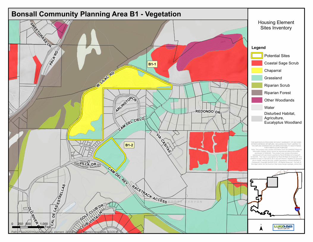
Bonsall Community Planning Area B1 - Vegetation
0 500 1,000250Feet ¯
∙ÿ
§̈¦
76
15
THIS MAP/DATA IS PROVIDED WITHOUT WARRANTY OF ANY KIND, EITHER EXPRESS OR IMPLIED, INCLUDING BUT NOT LIMITED TO, THE IMPLIED WARRANTIES OF MERCHANTABILITY AND FITNESS
FOR A PARTICULAR PURPOSE. Note: This product may contain information from the SANDAG Regional
Information System which cannot be reproduced without the writtenpermission of SANDAG. This product may contain information
reproduced with permission granted by Rand McNally & Company®to SanGIS. This map is copyrighted by Rand McNally & Company®. It is unlawful to copy or reproduce all or any part thereof, whether for personal
use or resale, without the prior, written permission of Rand McNally &Company®. Copyright SanGIS 2015 - All Rights Reserved. Full text of
this legal notice can be found at: http://www.sangis.org/legal_notice.htm