Countries World Oil Transit Chokepoints Background · ‹ Countries World Oil Transit Chokepoints...
13
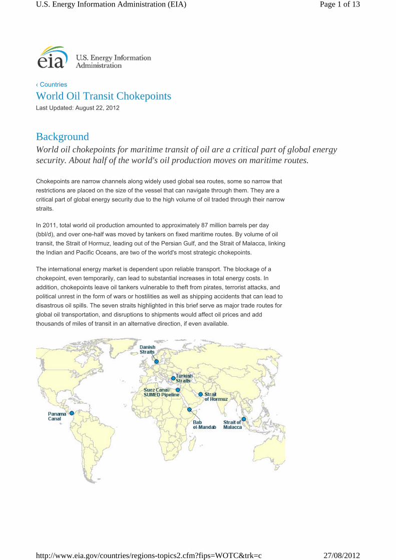
‹ Countries World Oil Transit Chokepoints Last Updated: August 22, 2012 Background World oil chokepoints for maritime transit of oil are a critical part of global energy security. About half of the world's oil production moves on maritime routes. Chokepoints are narrow channels along widely used global sea routes, some so narrow that restrictions are placed on the size of the vessel that can navigate through them. They are a critical part of global energy security due to the high volume of oil traded through their narrow straits. In 2011, total world oil production amounted to approximately 87 million barrels per day (bbl/d), and over one-half was moved by tankers on fixed maritime routes. By volume of oil transit, the Strait of Hormuz, leading out of the Persian Gulf, and the Strait of Malacca, linking the Indian and Pacific Oceans, are two of the world's most strategic chokepoints. The international energy market is dependent upon reliable transport. The blockage of a chokepoint, even temporarily, can lead to substantial increases in total energy costs. In addition, chokepoints leave oil tankers vulnerable to theft from pirates, terrorist attacks, and political unrest in the form of wars or hostilities as well as shipping accidents that can lead to disastrous oil spills. The seven straits highlighted in this brief serve as major trade routes for global oil transportation, and disruptions to shipments would affect oil prices and add thousands of miles of transit in an alternative direction, if even available. Page 1 of 13 U.S. Energy Information Administration (EIA) 27/08/2012 http://www.eia.gov/countries/regions-topics2.cfm?fips=WOTC&trk=c
-
Upload
truongnguyet -
Category
Documents
-
view
218 -
download
3
Transcript of Countries World Oil Transit Chokepoints Background · ‹ Countries World Oil Transit Chokepoints...
‹ Countries
World Oil Transit ChokepointsLast Updated: August 22, 2012
BackgroundWorld oil chokepoints for maritime transit of oil are a critical part of global energy security. About half of the world's oil production moves on maritime routes.
Chokepoints are narrow channels along widely used global sea routes, some so narrow that
restrictions are placed on the size of the vessel that can navigate through them. They are a
critical part of global energy security due to the high volume of oil traded through their narrow
straits.
In 2011, total world oil production amounted to approximately 87 million barrels per day
(bbl/d), and over one-half was moved by tankers on fixed maritime routes. By volume of oil
transit, the Strait of Hormuz, leading out of the Persian Gulf, and the Strait of Malacca, linking
the Indian and Pacific Oceans, are two of the world's most strategic chokepoints.
The international energy market is dependent upon reliable transport. The blockage of a
chokepoint, even temporarily, can lead to substantial increases in total energy costs. In
addition, chokepoints leave oil tankers vulnerable to theft from pirates, terrorist attacks, and
political unrest in the form of wars or hostilities as well as shipping accidents that can lead to
disastrous oil spills. The seven straits highlighted in this brief serve as major trade routes for
global oil transportation, and disruptions to shipments would affect oil prices and add
thousands of miles of transit in an alternative direction, if even available.
Page 1 of 13U.S. Energy Information Administration (EIA)
27/08/2012http://www.eia.gov/countries/regions-topics2.cfm?fips=WOTC&trk=c
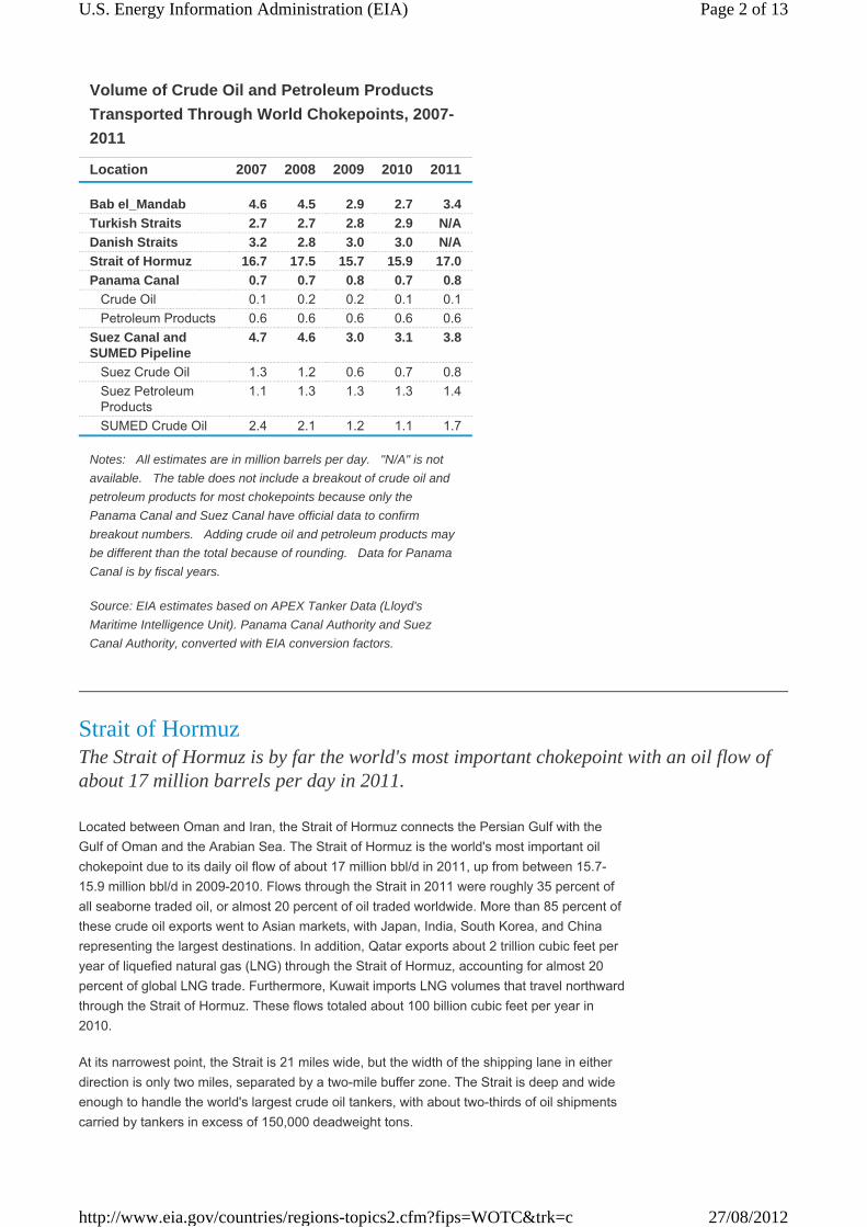
Location 2007 2008 2009 2010 2011
Bab el_Mandab 4.6 4.5 2.9 2.7 3.4
Turkish Straits 2.7 2.7 2.8 2.9 N/A
Danish Straits 3.2 2.8 3.0 3.0 N/A
Strait of Hormuz 16.7 17.5 15.7 15.9 17.0
Panama Canal 0.7 0.7 0.8 0.7 0.8
Crude Oil 0.1 0.2 0.2 0.1 0.1
Petroleum Products 0.6 0.6 0.6 0.6 0.6
Suez Canal and SUMED Pipeline
4.7 4.6 3.0 3.1 3.8
Suez Crude Oil 1.3 1.2 0.6 0.7 0.8
Suez Petroleum Products
1.1 1.3 1.3 1.3 1.4
SUMED Crude Oil 2.4 2.1 1.2 1.1 1.7
Notes: · All estimates are in million barrels per day. · "N/A" is not
available. · The table does not include a breakout of crude oil and
petroleum products for most chokepoints because only the
Panama Canal and Suez Canal have official data to confirm
breakout numbers. · Adding crude oil and petroleum products may
be different than the total because of rounding. · Data for Panama
Canal is by fiscal years.
Source: EIA estimates based on APEX Tanker Data (Lloyd's
Maritime Intelligence Unit). Panama Canal Authority and Suez
Canal Authority, converted with EIA conversion factors.
Volume of Crude Oil and Petroleum Products
Transported Through World Chokepoints, 2007-
2011
Strait of HormuzThe Strait of Hormuz is by far the world's most important chokepoint with an oil flow of about 17 million barrels per day in 2011.
Located between Oman and Iran, the Strait of Hormuz connects the Persian Gulf with the
Gulf of Oman and the Arabian Sea. The Strait of Hormuz is the world's most important oil
chokepoint due to its daily oil flow of about 17 million bbl/d in 2011, up from between 15.7-
15.9 million bbl/d in 2009-2010. Flows through the Strait in 2011 were roughly 35 percent of
all seaborne traded oil, or almost 20 percent of oil traded worldwide. More than 85 percent of
these crude oil exports went to Asian markets, with Japan, India, South Korea, and China
representing the largest destinations. In addition, Qatar exports about 2 trillion cubic feet per
year of liquefied natural gas (LNG) through the Strait of Hormuz, accounting for almost 20
percent of global LNG trade. Furthermore, Kuwait imports LNG volumes that travel northward
through the Strait of Hormuz. These flows totaled about 100 billion cubic feet per year in
2010.
At its narrowest point, the Strait is 21 miles wide, but the width of the shipping lane in either
direction is only two miles, separated by a two-mile buffer zone. The Strait is deep and wide
enough to handle the world's largest crude oil tankers, with about two-thirds of oil shipments
carried by tankers in excess of 150,000 deadweight tons.
Page 2 of 13U.S. Energy Information Administration (EIA)
27/08/2012http://www.eia.gov/countries/regions-topics2.cfm?fips=WOTC&trk=c

Source: U.S. Government (Click here to zoom out for alternate
routes)
Most potential options to bypass Hormuz are currently not operational. Only Iraq, Saudi
Arabia, and the United Arab Emirates (UAE) presently have pipelines able to ship crude oil
outside of the Gulf, and only the latter two countries currently have additional pipeline
capacity to circumvent Hormuz. At the start of 2012, the total available pipeline capacity from
the two countries combined, which is not utilized, was approximately 1 million bbl/d. The
amount could potentially increase to 4.3 million bbl/d by the end of this year, as both
countries have recently completed steps to increase standby pipeline capacity to bypass the
Strait.
Iraq has one major crude oil pipeline, the Kirkuk-Ceyhan (Iraq-Turkey) Pipeline that
transports oil from the north of Iraq to the Turkish Mediterranean port of Ceyhan. This
pipeline pumped about 0.4 million bbl/d in 2011, far below its nameplate capacity of 1.6
million bbl/d and it has been the target of sabotage attacks. Moreover, this pipeline cannot
send additional volumes to bypass the Strait of Hormuz unless it receives oil from southern
Iraq via the Strategic Pipeline, which links northern and southern Iraq. Currently, portions of
the Strategic Pipeline are closed, and renovations to the Strategic Pipeline could take several
years to complete.
Saudi Arabia has the 745-mile-long Petroline, also known as the East-West Pipeline, which
runs from across Saudi Arabia from its Abqaiq complex to the Red Sea. The Petroline
system consists of two pipelines with a total nameplate capacity of about 4.8 million bbl/d.
The 56-inch pipeline has a nameplate capacity of 3 million bbl/d and its current throughput is
about 2 million bbl/d. The 48-inch pipeline had been operating in recent years as a natural
gas pipeline, but Saudi Arabia recently converted it back to an oil pipeline. The switch could
increase Saudi Arabia's spare oil pipeline capacity to bypass the Strait of Hormuz from 1
million bbl/d to 2.8 million bbl/d, which is only attainable if the system is able to operate at its
full nameplate capacity.
The UAE constructed a 1.5 million bbl/d Abu Dhabi Crude Oil Pipeline that runs from
Habshan, a collection point for Abu Dhabi's onshore oil fields, to the port of Fujairah on the
Gulf of Oman, allowing crude oil shipments to circumvent Hormuz. The pipeline was recently
opened and the first shipment of 500,000 barrels of oil was sent through the pipeline to the
Fujairah oil terminal where it was loaded on a tanker and sent to the Pak-Arab Refinery in
Pakistan. The pipeline will be able to export up to 1.5 million bb/d, or more than half of UAE's
total net oil exports, once it reaches full operational capacity in the near future. However, the
UAE does not currently have the ability to utilize this pipeline completely, until it ramps to full
capacity. In late May, Fujairah ruler Sheikh Hamad bin Mohammed Al-Sharqi noted that this
pipeline capacity could rise further to a maximum 1.8 million bbl/d.
Page 3 of 13U.S. Energy Information Administration (EIA)
27/08/2012http://www.eia.gov/countries/regions-topics2.cfm?fips=WOTC&trk=c

Currently Operable Pipelines that are Unavailable as Bypass OptionsSaudi Arabia also has two additional pipelines that run parallel to the Petroline system and
bypass the Strait of Hormuz, but neither of them have the ability to transport additional
volumes of oil should the Strait of Hormuz be closed. The Abqaiq-Yanbu natural gas liquids
pipeline has a capacity of 290,000 bbl/d and is running at capacity. The IPSA (Iraqi Pipeline
through Saudi Arabia) is used to transport natural gas to Saudi Arabia's western coast. It was
originally built to carry 1.65 million bbl/d of crude oil from Iraq to the Red Sea, but Saudi
Arabia later converted it to carry natural gas, and has not announced plans to convert it back
to transport crude oil.
Other pipelines, such as the Trans-Arabian Pipeline (TAPLINE) running from Qaisumah in
Saudi Arabia to Sidon in Lebanon, have been out of service for years due to war damage,
disuse, or political disagreements, and would require a complete renovation before being
usable. Relatively small quantities, several hundred thousand barrels per day at most, could
be trucked to mitigate closure of the Strait of Hormuz.
Pipeline
Kirkuk-Ceyhan
(Iraq-Turkey)
Pipeline 1
Petroline
(East-West
Pipeline)
Abu Dhabi
Crude Oil
Pipeline Total
Owner Iraq Saudi Arabia
United Arab
Emirates
2011 (average)
Capacity 0.4 3.0 0.0 3.4
Throughput 0.4 2.0 0.0 2.4
Unused Capacity 2
0.0 1.0 0.0 1.0
2012 (mid-year) 3
Capacity 0.4 4.8 1.5 6.7
Throughput 4 0.4 2.0 0.0 2.4
Unused Capacity 0.0 2.8 1.5 4.3
Notes: All estimates are as of August 17, 2012 and expressed in million barrels per day (bbl/d). 1Although the Kirkuk-Ceyhan Pipeline has a nominal nameplate capacity of 1.6 million bbl/d, its
effective capacity is 0.4 million bbl/d because it cannot transport additional volumes of oil until
the Strategic Pipeline to which it links can be repaired to bring in additional volumes of oil from
the south of Iraq. 2"Unused Capacity" is defined as pipeline capacity that is not currenlty utlized and can be
readily available. 3All estimates for 2012 are rates around the mid-year point; not the forecast average for 2012.
4The 2012 throughput rates are based off of 2011 estimates.
Source: EIA
Currently Operable Crude Oil Pipelines that Bypass the Strait of
Hormuz
MalaccaThe Strait of Malacca, linking the Indian and Pacific Oceans, is the shortest sea route between the Middle East and growing Asian markets.
Page 4 of 13U.S. Energy Information Administration (EIA)
27/08/2012http://www.eia.gov/countries/regions-topics2.cfm?fips=WOTC&trk=c

Source: U.S. Government (Click here to zoom)
The Strait of Malacca, located between Indonesia, Malaysia, and Singapore, links the Indian
Ocean to the South China Sea and Pacific Ocean. Malacca is the shortest sea route
between Persian Gulf suppliers and the Asian markets—notably China, Japan, South Korea,
and the Pacific Rim. Oil shipments through the Strait of Malacca supply China and Indonesia,
two of the world's fastest growing economies. It is the key chokepoint in Asia with an
estimated 15.2 million bbl/d flow in 2011, compared to 13.8 million bbl/d in 2007. Crude oil
makes up about 90 percent of flows, with the remainder being petroleum products.
At its narrowest point in the Phillips Channel of the Singapore Strait, Malacca is only 1.7
miles wide creating a natural bottleneck, as well as potential for collisions, grounding, or oil
spills. According to the International Maritime Bureau's Piracy Reporting Centre, piracy,
including attempted theft and hijackings, is a constant threat to tankers in the Strait of
Malacca, although the number of attacks has dropped due to the increased patrols by the
littoral states' authorities since July 2005.
Over 60,000 vessels transit the Strait of Malacca per year. If the strait were blocked, nearly
half of the world's fleet would be required to reroute around the Indonesian archipelago
through Lombok Strait, located between the islands of Bali and Lombok, or the Sunda Strait,
located between Java and Sumatra.
There have been several proposals to build bypass options and reduce tanker traffic through
the Strait of Malacca, but most have not been followed through. China is on schedule to
complete the Myanmar-China Oil and Gas Pipeline in 2013, two parallel oil and gas pipelines
that stretch from Myanmar's ports in the Bay of Bengal to the Yunnan province of China. The
oil pipeline will be an alternative transport route for crude oil imports from the Middle East to
potentially bypass the Strait of Malacca. The oil pipeline capacity is expected to reach about
440,000 bbl/d.
Suez Canal/SUMED PipelineThe Suez Canal and SUMED Pipeline are strategic routes for Persian Gulf oil shipments to Europe. Closure of the Suez Canal and SUMED Pipeline would add an estimated 6,000 miles of transit around the continent of Africa.
Page 5 of 13U.S. Energy Information Administration (EIA)
27/08/2012http://www.eia.gov/countries/regions-topics2.cfm?fips=WOTC&trk=c

Suez CanalThe Suez Canal is located in Egypt, and connects the Red Sea and Gulf of Suez with the
Mediterranean Sea, spanning 120 miles. In 2011, petroleum (both crude oil and refined
products) and liquefied natural gas (LNG) accounted for 15 and 6 percent of Suez cargoes,
measured by cargo tonnage, respectively.
In 2011, 17,799 ships transited the Suez Canal from both directions, of which 20 percent
were petroleum tankers and 6 percent were LNG tankers. Only 1,000 feet wide at its
narrowest point, the Canal is unable to handle Ultra Large Crude Carriers (ULCC) and most
fully laden Very Large Crude Carriers (VLCC) class crude oil tankers. The table above shows
weight and capacity for the different tanker types. The Suezmax was the largest ship capable
of navigating through the Canal until 2010 when the Suez Canal Authority extended the
depth to 66 feet to allow over 60 percent of all tankers to use the Canal, including ships that
are 220,000 of dead weight tons in size.
Tanker
Type
Deadweight
Tons
Approximate Capacity
(Barrels)
Panamax 60,000 - 100,000
440,000 - 730,000
Aframax 80,000 - 120,000 850,000 - 880,000
Suezmax 120,000 - 200,000
880,000 - 1,500,000
VLCC 200,000 - 320,000
1,500,000 - 2,350,000
ULCC 320,000+ 2,350,000+
Source: Clarksons
Generally used oil tanker terminology
SUMED PipelineThe 200-mile long SUMED Pipeline, or Suez-Mediterranean Pipeline, provides an alternative
to the Suez Canal for those cargos too large to transit through the Canal (laden VLCCs and
larger). The crude oil flows through two parallel pipelines that are 42-inches in diameter, with
a total pipeline capacity of around 2.4 million bbl/d. Oil flows north through Egypt, and is
carried from the Ain Sukhna onshore terminal on the Red Sea coast to its end point at the
Sidi Kerir terminal on the Mediterranean. The SUMED is owned by Arab Petroleum Pipeline
Co., a joint venture between the Egyptian General Petroleum Corporation (EGPC), Saudi
Aramco, Abu Dhabi's National Oil Company (ADNOC), and Kuwaiti companies.
The SUMED Pipeline is the only alternative route to transport crude oil from the Red Sea to
the Mediterranean if ships were unable to navigate through the Suez Canal. Closure of the
Suez Canal and the SUMED Pipeline would divert oil tankers around the southern tip of
Africa, the Cape of Good Hope, adding approximately 6,000 miles to transit, increasing both
costs and shipping time. According to the International Energy Agency (IEA), shipping
around Africa would add 15 days of transit to Europe and 8-10 days to the United States.
Fully laden VLCCs transiting toward the Suez Canal also use the SUMED Pipeline for
lightering. Lightering occurs when a vessel needs to reduce its weight and draft by offloading
cargo in order to enter a restrictive waterway, such as a canal. The Suez Canal is not deep
enough to withstand a fully laden VLCC and, therefore, a portion of the crude is offloaded at
the SUMED Pipeline at the Ain Sukhna terminal. The now partially laden VLCC then goes
Page 6 of 13U.S. Energy Information Administration (EIA)
27/08/2012http://www.eia.gov/countries/regions-topics2.cfm?fips=WOTC&trk=c

Source: U.S. Energy Information Administration
through the Suez Canal and picks up the portion of its crude at the other end of the pipeline,
which is the Sidi Kerir terminal.
Crude OilThe majority of crude oil transiting the Suez Canal travels northbound, towards markets in
the Mediterranean and North America. Northbound canal flows averaged approximately
535,000 bbl/d of crude oil in 2011. The SUMED Pipeline accounted for about 1.7 million bbl/d
of crude oil flows from the Red Sea to the Mediterranean over that same period. Combined,
these two transit points were responsible for nearly 2.2 million bbl/d of crude oil flows into the
Mediterranean. Northbound crude transit has declined by almost half since its level in 2008
when 943,000 bbl/d of crude transited northbound through the Canal and an additional 2.1
million bbl/d of crude travelled through the SUMED to the Mediterranean. Contrarily, crude oil
shipments travelling southbound through the Canal toward the Red Sea, primarily destined
for Asian markets, increased from 2008 through 2010, but fell slightly in 2011.
Total Oil and ProductsTotal oil flows from the Suez Canal declined steeply by more than one-third in 2009 to about
1.8 million bbl/d, down from 2008 levels of over 2.4 million bbl/d. Crude oil flows through the
SUMED experienced a much steeper drop to1.2 million bbl/d from approximately 2.1 million
bbl/d over the same period. The year-over-year difference reflects the collapse in world oil
Page 7 of 13U.S. Energy Information Administration (EIA)
27/08/2012http://www.eia.gov/countries/regions-topics2.cfm?fips=WOTC&trk=c

market demand that began in the fourth quarter of 2008, followed by OPEC production cuts
(primarily from the Persian Gulf), which caused a sharp fall in regional oil trade starting in
January 2009. Drops in transit also illustrate the changing dynamics of international oil
markets where Asian demand is increasing at a higher rate than European and U.S. markets,
and West African crude production is meeting a greater share of the latter's demand. At the
same time, piracy and security concerns around the Horn of Africa have led some exporters
to travel the extra distance around South Africa to reach West African markets. Total oil flows
through the Suez Canal increased year-over year to almost 2.2 million bbl/d in 2011, but still
remain below previous levels prior to the global economic downturn.
Liquefied Natural Gas (LNG)Unlike oil, LNG transit through the Suez Canal has been on the rise since 2008, with the total
number of laden tankers increasing from approximately 210 to over 500, and volumes of
LNG traveling northbound (laden tankers) increasing nearly six-fold. Southbound LNG transit
originates in Algeria and Egypt, destined for Asian markets while northbound transit is mostly
from Qatar and Oman, destined for European and North American markets. The rapid growth
in LNG flows over the period represents the startup of five LNG trains in Qatar in 2009-2010.
The only alternate route for LNG tankers would be around Africa as there is no pipeline
infrastructure to offset any Suez Canal disruptions. Countries such as the United Kingdom,
Belgium, and Italy received over 80 percent their total LNG imports via the Suez Canal in
2010, while Turkey, France, and the United States had about a quarter of their LNG imports
transited through the Canal.
Page 8 of 13U.S. Energy Information Administration (EIA)
27/08/2012http://www.eia.gov/countries/regions-topics2.cfm?fips=WOTC&trk=c
Source: U.S. Government (Click here to zoom)
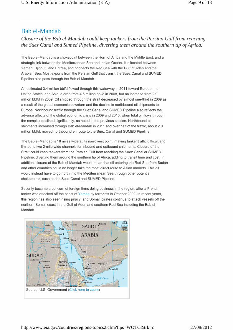
Bab el-MandabClosure of the Bab el-Mandab could keep tankers from the Persian Gulf from reaching the Suez Canal and Sumed Pipeline, diverting them around the southern tip of Africa.
The Bab el-Mandab is a chokepoint between the Horn of Africa and the Middle East, and a
strategic link between the Mediterranean Sea and Indian Ocean. It is located between
Yemen, Djibouti, and Eritrea, and connects the Red Sea with the Gulf of Aden and the
Arabian Sea. Most exports from the Persian Gulf that transit the Suez Canal and SUMED
Pipeline also pass through the Bab el-Mandab.
An estimated 3.4 million bbl/d flowed through this waterway in 2011 toward Europe, the
United States, and Asia, a drop from 4.5 million bbl/d in 2008, but an increase from 2.9
million bbl/d in 2009. Oil shipped through the strait decreased by almost one-third in 2009 as
a result of the global economic downturn and the decline in northbound oil shipments to
Europe. Northbound traffic through the Suez Canal and SUMED Pipeline also reflects the
adverse affects of the global economic crisis in 2009 and 2010, when total oil flows through
the complex declined significantly, as noted in the previous section. Northbound oil
shipments increased through Bab el-Mandab in 2011 and over half of the traffic, about 2.0
million bbl/d, moved northbound en route to the Suez Canal and SUMED Pipeline.
The Bab el-Mandab is 18 miles wide at its narrowest point, making tanker traffic difficult and
limited to two 2-mile-wide channels for inbound and outbound shipments. Closure of the
Strait could keep tankers from the Persian Gulf from reaching the Suez Canal or SUMED
Pipeline, diverting them around the southern tip of Africa, adding to transit time and cost. In
addition, closure of the Bab el-Mandab would mean that oil entering the Red Sea from Sudan
and other countries could no longer take the most direct route to Asian markets. This oil
would instead have to go north into the Mediterranean Sea through other potential
chokepoints, such as the Suez Canal and SUMED Pipeline.
Security became a concern of foreign firms doing business in the region, after a French
tanker was attacked off the coast of Yemen by terrorists in October 2002. In recent years,
this region has also seen rising piracy, and Somali pirates continue to attack vessels off the
northern Somali coast in the Gulf of Aden and southern Red Sea including the Bab el-
Mandab.
Page 9 of 13U.S. Energy Information Administration (EIA)
27/08/2012http://www.eia.gov/countries/regions-topics2.cfm?fips=WOTC&trk=c

Source: U.S. Government (Click here to zoom)
Turkish StraitsIncreased oil exports from the Caspian Sea region make the Turkish Straits one of the busiest and most dangerous chokepoints in the world supplying Western and Southern Europe.
The Bosporus and Dardanelles are the Turkish Straits and divide Asia from Europe. The
Bosporus is a 17-mile long waterway that connects the Black Sea with the Sea of Marmara,
and the Dardanelles is a 40-mile long waterway that links the Sea of Marmara with the
Aegean and Mediterranean Seas. Both are located in Turkey and supply Western and
Southern Europe with oil from the Caspian Sea Region.
An estimated 2.9 million bbl/d flowed through the Turkish Straits in 2010, almost all of which
was crude oil. The ports of the Black Sea are one of the primary oil export routes for Russia
and other former Soviet Union republics. Oil shipments through the Turkish Straits decreased
from over 3.4 million bbl/d at its peak in 2004 to 2.6 million bbl/d in 2006 as Russia shifted
crude oil exports toward the Baltic ports. Traffic through the Straits increased again as crude
production and exports from Azerbaijan and Kazakhstan rose in recent years.
Only half a mile wide at its narrowest point, the Turkish Straits are one of the world's most
difficult waterways to navigate due to its sinuous geography. With 50,000 vessels, including
5,500 oil tankers, passing through the straits annually it is also one of the world's busiest
chokepoints.
Turkey has raised concerns over the navigational safety and environmental threats to the
Straits. Commercial shipping has the right of free passage through the Turkish Straits in
peacetime, although Turkey claims the right to impose regulations for safety and
environmental purposes. Bottlenecks and heavy traffic also create problems for oil tankers in
the Turkish Straits. While there are no current alternate routes for westward shipments from
the Black and Caspian Sea region, there are several pipeline projects in various phases of
development underway.
Page 10 of 13U.S. Energy Information Administration (EIA)
27/08/2012http://www.eia.gov/countries/regions-topics2.cfm?fips=WOTC&trk=c

Panama CanalThe United States is the top country of origin and destination for all commodities transiting through the Panama Canal; however, it is not a significant route for U.S. petroleum trade.
The Panama Canal is an important route connecting the Pacific Ocean with the Caribbean
Sea and Atlantic Ocean. The Canal is 50 miles long, and only 110 feet wide at its narrowest
point called Culebra Cut on the Continental Divide. Over 14,000 vessels transit the Canal
annually, of which more than 60 percent (by tonnage) represent United States coast-to-coast
trade, along with United States trade to and from the world that passed through the Panama
Canal.
Closure of the Panama Canal would greatly increase transit times and costs adding over
8,000 miles of travel. Vessels would have to reroute around the Straits of Magellan, Cape
Horn and Drake Passage under the tip of South America.
However, the Panama Canal is not a significant route for petroleum transit or for U. S.
petroleum imports. Roughly one-fifth of the traffic through the canal (measured by both
transits and tonnage) was by tankers. According to the Panama Canal Authority, 755,000
bbl/d of crude and petroleum products were transported through the canal in Fiscal Year
2011, of which 637,000 bbl/d were refined products, and the rest crude oil (EIA conversions
from long tons to barrels). Nearly 80 percent of total petroleum, or 608,000 bbl/d, passed
from north (Atlantic) to south (Pacific).
The relevance of the Panama Canal to the global oil trade has diminished, as many modern
tankers are too large to travel through the canal. Some oil tankers, such as the ULCC (Ultra
Large Crude Carriers) class tankers, can be nearly five times larger than the maximum
capacity of the canal. The largest vessel that can transit the Panama Canal is known as a
PANAMAX-size vessel (ships ranging from 60,000 � 100,000 dead weight tons in size
and no wider than 108 ft.)
In order to make the canal more accessible, the Panama Canal Authority began an
expansion program to be completed by the end of 2014. However, while many larger tankers
will be able to transit the canal after 2014, some ULCCs will still be unable to make the
transit. The Panama Canal Authority features a description of the expansion program and
progress reports.
Page 11 of 13U.S. Energy Information Administration (EIA)
27/08/2012http://www.eia.gov/countries/regions-topics2.cfm?fips=WOTC&trk=c
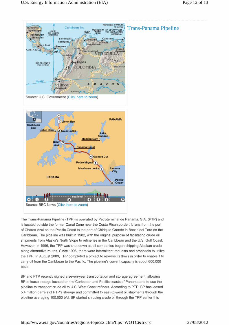
Source: U.S. Government (Click here to zoom)
Source: BBC News (Click here to zoom)
Trans-Panama Pipeline
The Trans-Panama Pipeline (TPP) is operated by Petroterminal de Panama, S.A. (PTP) and
is located outside the former Canal Zone near the Costa Rican border. It runs from the port
of Charco Azul on the Pacific Coast to the port of Chiriquie Grande in Bocas del Toro on the
Caribbean. The pipeline was built in 1982, with the original purpose of facilitating crude oil
shipments from Alaska's North Slope to refineries in the Caribbean and the U.S. Gulf Coast.
However, in 1996, the TPP was shut down as oil companies began shipping Alaskan crude
along alternative routes. Since 1996, there were intermittent requests and proposals to utilize
the TPP. In August 2009, TPP completed a project to reverse its flows in order to enable it to
carry oil from the Caribbean to the Pacific. The pipeline's current capacity is about 600,000
bbl/d.
BP and PTP recently signed a seven-year transportation and storage agreement, allowing
BP to lease storage located on the Caribbean and Pacific coasts of Panama and to use the
pipeline to transport crude oil to U.S. West Coast refiners. According to PTP, BP has leased
5.4 million barrels of PTP's storage and committed to east-to-west oil shipments through the
pipeline averaging 100,000 b/d. BP started shipping crude oil through the TPP earlier this
Page 12 of 13U.S. Energy Information Administration (EIA)
27/08/2012http://www.eia.gov/countries/regions-topics2.cfm?fips=WOTC&trk=c

year. The route reduces transport time and costs of ships having to go around Cape Horn at
the tip of South America to get to the U.S. West Coast.
Danish StraitsThe Danish Straits are becoming an increasingly important route for Russian oil exports to Europe.
About 3 million bbl/d flowed through this waterway in 2010, with most of this flowing
westwards. Russia has increasingly been shifting its crude oil exports to its Baltic ports,
especially the relatively new port of Primorsk, which accounted for half of the exports through
the Straits. An estimated 0.3 million bbl/d of crude oil, primarily from Norway, flowed
eastward to Scandinavian markets.
About one-third of the westward exports through the Straits are for refined products, coming
from Baltic Sea ports such as Tallinn (Muuga), Venstpils, and St. Petersburg.
SourcesC.I.A. World Factbook•
Clarksons•
Eastern Bloc Research•
International Energy Agency (IEA)•
International Maritime Bureau•
Lloyd's List Intelligence•
Panama Canal Authority•
Petroterminal de Panama, S.A.•
Suez Canal Authority •
U.S. Energy Information Administration•
Page 13 of 13U.S. Energy Information Administration (EIA)
27/08/2012http://www.eia.gov/countries/regions-topics2.cfm?fips=WOTC&trk=c


![E b >[h jW][](https://static.fdocuments.us/doc/165x107/5fcf68be9f807d260772f91e/-e-b-h-jw-.jpg)